Embed Size (px)
Citation preview

WORLD METEOROLOGICAL ORGANIZATION
POST-TYPHOON HAIYAN EXPERT MISSION TO VIET NAM
HANOI, 14-16 APRIL 2014
MISSION REPORT

CONTENTS
1. Introduction ............................................................................................................................ 1
2. National Response to Typhoon Haiyan in Viet Nam .......................................................... 2
3. International Response to Typhoon Haiyan in Viet Nam ................................................... 3
4. Requirements of the Emergency Response and Disaster Reduction Authorities, Mass
Media, and NHMS ................................................................................................................... 7
5. SWFDP Contribution to the Role of NHMS in Providing Guidance to Save Life and
Property .................................................................................................................................. 8
6. Conclusions and Recommendations ................................................................................... 9
Appendix I: List of the Members of the Mission Team ............................................................. 11
Appendix II: Terms of Reference ................................................................................................ 12
Appendix III: Programme of the Mission ................................................................................... 13
Appendix IV: List of Persons Consulted ................................................................................... 14
Appendix V: Best Track Data of Haiyan by RSMC Tokyo and the Storm Surge Height
Prediction by NHMS ............................................................................................................ 16
Appendix VII: Photos ................................................................................................................... 19

REPORT OF THE WMO POST-TYPHOON HAIYAN EXPERT MISSION TO VIET NAM
14-16 APRIL 2014 1. Introduction 1.1 Typhoon Haiyan, one of the strongest typhoons ever recorded, crossed the Philippines on 8 November 2013, caused significant casualties and disruption to socio-economic activities in the Philippines. The typhoon was predicted to make land fall in Viet Nam a few days later. 1.2 The National Hydro-Meteorological Service (NHMS) of Viet Nam requested the members of the ESCAP/WMO Typhoon Committee, the World Meteorological Organization (WMO) and relevant institutions to advise how to cope with the unprecedented strong typhoon and to share the experiences. The typhoon did not cross central Viet Nam and its track curved along the coastline and hence the damage caused by Haiyan was minimal in Viet Nam. Nevertheless, the support provided to NHMS by some members of the Typhoon Committee including China; Hong Kong, China; Japan and the United States with the coordination by the WMO Secretariat was found useful by NHMS. Organization of the mission 1.3 A WMO expert mission to Viet Nam was carried out from14 to 16 April 2014 to assess the current capacity and capability of NHMS and requirements of the relevant authorities in Viet Nam and to make recommendations to address specific aspects identified by the gap analysis. The mission team was composed of eight (8) experts from the Hong Kong Observatory (HKO), the Regional Specialized Meteorological Center (RSMC) Tokyo - Typhoon Center/the Japan Meteorological Agency (JMA), the United Kingdom Met. Office (UKMO) and WMO. The list of the members of the mission team and Terms of Reference of the mission are given in Appendix I and Appendix II, respectively.
1.4 The programme of the mission, given in Appendix III, included: (1) a meeting with NHMS and stakeholders; (2) a meeting with the National Center for Hydro-Meteorological Forecasting (NCHMF) of NHMS, (3) a technical tour of the operational facilities of NHMS, (4) meetings with the Central Committee for Flood and Storm Control (CCFSC) and the Viet Nam Television Weather and Disaster Broadcast Center (VTV-WDB), and (5) meetings with senior officials of NHMS on conclusions and recommendations of the mission. The list of persons consulted during the mission is given in Appendix IV. Typhoon Haiyan 1.5 Haiyan formed as a Tropical Depression (TD) over the sea southwest of Pohnpei Island at 06 UTC on 3 November 2013. Moving westward, it was upgraded to Tropical Storm (TS) intensity south of the Chuuk Islands at 00 UTC on 4 November. Keeping its westward track, Haiyan was upgraded to Typhoon (TY) intensity over the sea southeast of the Yap Islands at 12 UTC on 5 November and it reached its peak intensity with maximum sustained winds of 125 knots (64.3 m/s) and a central pressure of 895 hPa northeast of Mindanao Island at 12 UTC on 7 November. Moving west-northwestward, Haiyan crossed the Philippines with TY intensity and entered the South China Sea late on 8 November. Turning gradually northwestward, it was downgraded to Severe Tropical Storm (STS) intensity over the Gulf of Tonkin at 18 UTC on 10 November. On the early morning of 11 November, Haiyan made landfall in Quang Ninh Province of Viet Nam. A peak gust of 41 m/s was recorded at Coto Island, and accumulated total precipitation of 461 mm was recorded at Mauson. After the landfall on the northern part of Viet Nam with TS intensity, Haiyan was downgraded to TD intensity over the southern part of China at 06 UTC on 11 November and dissipated six hours later. The best track data of Haiyan by RSMC Tokyo and the storm surge height prediction by NHMS are given in Appendix V.
2
2. National Response to Typhoon Haiyan in Viet Nam 2.1 The Government of Viet Nam and NHMS responded to Haiyan as follows: 4 November
Early warning on TD. Morning, 5 November
Early warning on TS, STS and Typhoon. Night, 6 November
Bulleting on “TS near East Sea” which warned that Haiyan could enter East Sea in the coming 48 – 60h. Relevant high-ranking officials including the Prime Minister were constantly and duly informed of the behaviors of Haiyan. Issue 4 bulletins/day. Strict order to fishermen to come back to nearest safe shelter ports.
Morning, 8 November
Teleconference among NHMS forecasting offices headed by Vice Minister of the Ministry of Natural Resources and Environment (MONRE).
Afternoon, 8 November
A letter of request was sent by NHMS to WMO, the Typhoon Committee, major forecasting centers for assistance.
Evening, 8 November
Bulletin “TS in the East Sea” (since this time, bulletins were issued 8 times/day). MONRE Vice Minister and some NHMS staff also made an immediate mission to give on-site direction and assist Mid-Central Regional Hydro-Meteorological Centers (RHMCs).
Prime Minister Mr Nguyen Tan Dzung chaired the CCFSC teleconference; the Prime Minister called on the ministries and agencies concerned to do all they can to minimize human and material losses. He said: “Preventing typhoon Haiyan is the task of the political system, party committees, governments, the army, police and the relevant agencies of all levels. We must mobilize all available resources to minimize human and property losses”.
Two (2) Deputy Prime Ministers, Mr Nguyen Xuan Phuc and Mr Hoang Trung Hai left for central provinces to inspect preparations for Haiyan. They ordered the evacuation should be completed before 7:00 p.m. on 9 November.
The Ministry of Agriculture and Rural Development (MARD) Minister cum Chairman of CCFSC, Mr Cao Duc Phat visited the central provinces to give on-site instruction of preparation for Haiyan. Six (6) task forces were sent to central provinces to inspect and protect dykes, dams and other irrigation works.
The Ministry of Foreign Affairs sent a diplomatic note to the embassies of China, the Philippines, Indonesia and Malaysia in Viet Nam and the embassies of Viet Nam abroad, asking for all possible support in case of emergency.
Noon, 9 November
When Haiyan passed 112°E, NHMS issued a bulletin on “Near shore typhoon” and warned of the typhoon’s movement speed, possible change of direction, affected area, etc. More than 600,000 people in Mid-central provinces were evacuated. Nearly 200,000 people in the North-Central provinces were ready for evacuation.
3
Noon, 10 November
When the typhoon center was about 190 km east of Thua Thien-Hue province, a bulletin on “Urgent TS” was issued with warning for the coming 12 hours on the typhoon’s speed (about 30-35 km/h), direction (along the coast from Thua Thien-Hue to Nghe An), then it may change direction to NWN-N with slowed down speed of 15 km/h and land on coastal provinces in the North Viet Nam. Hourly bulletins were issued.
Evacuated people in central provinces went back home in order. Early morning, 11 November
Haiyan made landfall in Hai Phong-Quang Ninh provinces. 2.2 NHMS worked with mass media as follows: 7 November
NHMS initiated to work closely with VTV1. 9 November
NHMS provided information to VTV1, News Agency TV, HTV9, VTC14, VOV and 12 newspaper agencies.
10 November
NHMS provided information to VTV1, News Agency TV, HTV9, VTC14, VOV, QPTV, ANTV, VTC1 and 23 newspaper agencies.
From 15h30m on 9 November to 04h00m 11 November
NHMS collaborated with VTV1 in setting up a live TV bridge with provinces to provide continuous updated forecasts and warnings to serve for prevention and preparedness activities.
10 November
NHMS provide information on Haiyan to CCTV of China. 2.3 During the Haiyan event, some private SMS providers voluntarily sent messages on typhoon Haiyan information to the users in the possibly affected area. 3. International Response to Typhoon Haiyan in Viet Nam 3.1 Background 3.1.1 On 8 November 2013, NHMS sent a letter requesting ESCAP/WMO Typhoon Committee Members, the WMO Secretariat, the RSMC Tokyo-Typhoon Centre, the US National Weather Service (NWS), and the Asian Disaster Prevention and Preparedness Centre (ADPC) to provide advices on “what measures to be taken and how to mobilize all the available resources (especially, how to deal effectively with the mass media and the public) to minimize the possible losses”. In response to the request, the WMO Secretariat organized a small Emergency Response Team (ERT) and requested the RSMC Tokyo, the China Meteorological Administration (CMA) and HKO to provide technical assistance in forecasting and warning of Haiyan and experiences and practices in disaster mitigation and preparedness measures, while the RSMC Tokyo, NWS and the Typhoon Committee Secretariat (TCS) responded separately to the request by the WMO Secretariat.

4
3.1.2 The Meeting of Presidents of Technical Commissions (PTC), held on 20-21 January 2014 in Geneva, Switzerland, concluded that the emergency response to a special request for assistance from NHMS successfully resulted in limited impacts of Haiyan on Viet Nam in terms of loss of lives and damages to properties. It also emphasized that in-depth and complete analyses should be carried out to find out how and what actions should be taken to benefit the Members in the future. The 46th session of the Typhoon Committee, held on 10-13 February 2014 in Bangkok, Thailand, discussed the above response and expressed the need of full analysis of the response, including whether it made difference emergency responses in Viet Nam, and if so, how it might be improved for future emergency response by each Member in similar situations. 3.2 Assessment of the External Supports to NHMS 3.2.1 The mission team, in cooperation with NHMS, made assessments on the effectiveness of supports provided by the RSMC Tokyo – Typhoon Centre, major members of the Typhoon Committee and advanced centers in response to the request from NHMS as follows: (1) Forecast Supporting Products (1-a) TC Forecasts
3.2.2 NHMS reported that the TC track guidance of major Numerical Weather Prediction (NWP) centres including JMA, the European Centre for Medium-Range Weather Forecasts (ECMWF), the US National Centers for Environment Prediction (NCEP), UKMO, CMA, and the Korea Meteorological Administration (KMA) were provided by CMA and HKO via e-mail. The access to the website on the Tropical Region Assimilation Model for South China Sea (TRAMS) was informed by the CMA’s Guangzhou Regional Meteorological Centre (GRMC). TC warning bulletins for shipping were also provided by HKO. 3.2.3 It was confirmed that the provided TC track guidance of the major global NWP centres was not used by NHMS, whereas the outputs of TRAMS and the HKO’s TC bulletins were referenced for its TC forecasts. It is because TC track guidance of major NWP models including the Integrated Forecasting System (IFS) of ECMWF, the Naval Global Environment Model (NAVGEM) of the US Navy's Fleet Numerical Meteorology and Oceanography Center, the Global Spectral Model (GSM) of JMA, and the GME of the German Weather Service (DWD), are fully available to NHMS’s forecasters. TcAid, the software developed by its own for TC forecasting provides various NWP products, including such TC guidance, to the forecasters in a graphical format. 3.2.4 NHMS also reported that a list of TC-related products available via the Internet was provided by NWS and partially referenced for its TC forecasts. (1-b) Storm Surge Forecasts
3.2.5 On 7 November, the RSMC Tokyo was requested by NHMS to provide technical assistance on storm surge forecasts. It was found that NHMS was not able to access the 6-hourly storm surge forecasts provided by the RSMC Tokyo for the Typhoon Committee Members on the Numerical Typhoon Prediction (NTP) website because of its strict security. The RSMC Tokyo, therefore, continued to provide the storm surge forecasts with technical advice via e-mail every six hours from 7 to 11 November 2013. It was referenced by NHMS to estimate potential risks of storm surges by Haiyan. (2) Enhanced Observations
3.2.6 NHMS was informed that CMA started rapid scan observation of Haiyan with its geostationary meteorological satellite, FY-2. However, due to technical problems with the FY-2 receiver at NHMS, NHMS was not able to receive those observational data.

5
(3) Good Practice of Emergency Responses
3.2.7 In response to the letter of NHMS dated 8 November 2013 requesting advice on emergency responses, the RSMC Tokyo, HKO and CMA provided NHMS with good practices and recommended actions to be taken by NHMS. The RSMC Tokyo, two and a half hours after the receipt of the letter, provided a list of recommended actions including useful materials on JMA’s emergency responses available via the Internet. HKO provided telephone consultations, the Contingency Plan on Natural Disasters of Hong Kong, as well as recommended mitigation measures and good practices. CMA also provided its National Disaster Response Plan. 3.2.8 According to CCFSC, the catastrophic damages to the Philippines by Haiyan triggered the Government of Viet Nam to immediately take full range of emergency responses well before the landfall of Haiyan; on the evening of 8 November 2013, Prime Minister Mr Nguyen Tan Dzung chaired the CCFSC teleconference and called on the ministries and agencies concerned to do all they can to minimize human and material losses; on the same day, Deputy Prime Ministers left for central provinces to inspect preparations for Haiyan, and ordered the completion of evacuation before 7:00 p.m. on 9 November 2013. Since all the necessary emergency responses had already been taken when the letter was sent by NHMS, the documents and good practices/recommendations provided by the RSMC Tokyo, CMA, and HKO were used by NHMS to double-check that its emergency responses were appropriate. (4) Video Conference/teleconference
3.2.9 It was confirmed that NHMS and CMA/Guangzhou Regional Meteorological Centre (GRMC) established the communication channel between their operational forecasters based on their bilateral agreement, while the video conference between NHMS and CMA headquarters was not conducted. Operational forecasters of NHMS and GRMC exchanged their views on their latest TC forecasts and uncertainty including expected landfall time and synoptic situations. NHMS considered the communication with GRMC by teleconference helped its forecasters to make updated TC forecasts as Haiyan approached the coasts of Viet Nam. 3.2.10 NHMS informed that because of relatively low frequency of extreme TC events in Viet Nam, NHMS operational forecasters do not have sufficient experiences to face severe TC events, and stressed the needs of forecasting guidance by experienced forecasters at advanced TC centres such as the RSMC Tokyo, particularly in the case of occurrence of extreme events like Haiyan in the future. NHMS also informed that its forecasters often have difficulties in interpreting NWP TC guidance to make consistent TC forecasts when there are large discrepancies between NWP models. The mission team emphasized that it is NHMS that has the responsibility of any decisions with TC warnings, and any forecasting guidance provided by other Members/centers shall be regarded as references. The mission team advised NHMS to conduct regular verification of TC forecasts of respective models and effective use of multi-model ensemble consensus. In addition, the mission team emphasized the importance of effectively conveying information on uncertainty of TC forecasts and potential changes of TC forecast scenarios to the users and the public. 3.3 Conclusions and recommendations on the follow-up actions to external supports to NHMS 3.3.1 The mission team identified that the existing functions of the WMO Global Data-Processing and Forecasting System (GDPFS) including RSMCs, significantly supported NHMS to make effective TC warnings in a timely manner. On the other hand, most of the additional supports provided by Members/centers concerned responding to the letter by NHMS were either not used or partially referenced by NHMS for its TC operational service, while the communication with GRMC, based on the bilateral agreement between NHMS and CMA, effectively helped NHMS forecasters to make TC forecasts. The impacts of Haiyan on Viet Nam were minimized not only because of the full range of national emergency responses taken by the Government of Viet Nam which was triggered by the catastrophic damages in the Philippines before the letter was sent, but also because Haiyan moved along the coast of Viet Nam although it was predicted to move to the
6
central part of Viet Nam when Haiyan was moving from the Philippines to Viet Nam and the intensity of Haiyan significantly weakened before its landfall in the northern part of Viet Nam. It should be noted that not all of the external supports by Members/centers concerned were coordinated under the WMO ERT as reported by the PTC meeting: the RSMC Tokyo and US-NWS responded individually, independently of the WMO ERT (the RSMC Tokyo established a hotline with NHMS on request from the ERT). Conclusions of respective items are summarized as follows: Forecast Supporting Products [1]
3.3.2 All products for TC and storm surge forecasts provided as stated in (1-a) and (1-b) above, except for TC track guidance of major NWP centres which were not used at NHMS, are available via the WMO Global Telecommunication System (GTS) and/or the Internet. For operational forecasters to utilize such products appropriately, well-understanding and familiarity with the products including their characteristics are indispensable. Product providers, therefore, should make those products available operationally for users and prepare technical materials and training opportunities to promote their appropriate use. Furthermore, providers and users regularly confirm whether users can access and use such products, preferably every before typhoon season. Storm Surge Forecasts [1-b]
3.3.3 Storm surge forecasts provided by the RSMC Tokyo under the Storm Surge Watch Scheme (SSWS) on the Numerical Typhoon Prediction (NTP) website were sent by e-mail due to inaccessibility of NHMS to the website because of its strict access restriction. The RSMC Tokyo and NHMS should work closely to ensure the access of NHMS. Furthermore, the access restriction policy of the website should be changed to ensure more flexible and sufficient access to the website. Time-series storm surge forecasts should be provided by the RSMC Tokyo at requested stations of NHMS starting from the coming typhoon season in 2014. NHMS successfully installed JMA’s storm surge model and will be ready for its operational use. Continuous technical supports by the RSMC Tokyo for NHMS to operationalize the storm surge model are indispensable. Enhanced Observations [2]
3.3.4 Rapid scan observations with FY-2 were not utilized due to technical problems at NHMS. However, in consideration of the effectiveness of rapid scan satellite observations for TC operational services, it is encouraged for satellite operators to operationally conduct rapid scan observations when TCs exist. Users should regularly check the receipt of satellite data so that such data can be used when necessary, preferably before the typhoon season. Good Practice of Emergency Responses [3]
3.3.5 NHMS recognized the recommendations and materials by the RSMC Tokyo, CMA, and HKO as useful. Thus, it would be worth for NHMS carefully reviewing and reflecting them, if appropriate, to its own emergency operation procedures in cooperation with relevant Disaster Risk Reduction (DRR) authorities during the off-typhoon season. Teleconference [4]
3.3.6 It was confirmed that the communication with GRMC was effective. Needs of NHMS for forecasting guidance of experienced TC forecasters at advanced centres such as the RSMC Tokyo on the latest TC and storm surge forecasts under the threat of catastrophic impacts of severe TCs like Haiyan are identified. In consideration of roles and responsibilities of the Regional Forecast Support Center (RFSC) Hanoi and the RSMC Tokyo as regional centres under the WMO Severe Weather Forecasting Demonstration Project (SWFDP) in Southeast Asia, the most effective and feasible implementation scheme, to produce/share forecasting guidance, particularly between the two regional centres, could be established. 3.4 Recommended follow-up actions
3.4.1 Based on the assessment and conclusions above, the mission team and NHMS agreed on the recommended follow-up actions as given in Appendix VI.

7
4. Requirements of the Emergency Response and Disaster Reduction Authorities, Mass Media, and NHMS Requirements of the emergency response and disaster reduction authorities and mass media 4.1 After holding the meetings with the CCFSC and the Viet Nam Television Weather and Disaster Broadcast Center (VTV-WDB), the mission team identified the requirements of the Emergency Response and Disaster Risk Reduction Authorities and mass media as follows: Emergency Response and Disaster Risk Reduction Authorities To continue working closely with NHMS and partners: (i) to improve efficiency in delivering warnings to regional offices and the general public; (ii) to provide timely reports on flooding, landslides, etc. for reference by forecasters; (iii) to develop precise inundation map and identify vulnerable areas for continual improvement
of warning and forecasting services; and (iv) to promote public educational programmes to increase preparedness on natural disasters. Mass Media: To continue working closely with NHMS and partners: (i) to identify resources/services (e.g. city forecast) available from the local meteorological
authorities as well as authorities from other countries; (ii) to identify new technology such as mobile phone and smartphone for delivering weather
forecasting and warning services by taking advantages of the latest technological advancement; and
(iii) to promote public educational programmes to increase preparedness on natural disasters. Requirements of NHMS in support for emergency response and disaster risk reduction 4.2 The mission team identified the requirements of NHMS in support for emergency response and disaster risk reduction as follows: (i) Continue to build observing network including automatic gauges for rain and tide as well as
radar stations in Viet Nam to gather high quality weather reports and observations to improve the quality of early warnings;
(ii) Continue to improve infrastructure including communication network to facilitate timely sharing of forecasting and warning products from headquarters to regional offices, and also timely transmission of observations and reports from regional stations to forecasting offices;
(iii) Continue to improve internal communications between meteorological and hydrological forecasters to further enhance the services for the key Public Weather Service (PWS) users;
(iv) Carry out verifications on forecasting and warning services, and conduct surveys to key PWS users with a view to identifying area of improvement;
(v) Continue to work with partners to enhance public educational programmes to increase the national preparedness on meteorological and hydrological disasters;
(vi) Continue to work with key PWS users to identify user needs and requirements for implementation of impact-based forecasting and risk-based warning services;
(vii) Embrace latest technologies with a view to further enhancing the efficiency of delivery of weather service in particular weather warnings to protect life and property. This can be achieved by exploring other dissemination channels such as interactive voice response telephone enquiry system, short message service, mobile apps, etc., in delivering weather service to the key PWS users including general public in a more effective and efficient manner.

8
5. SWFDP Contribution to the Role of NHMS in Providing Guidance to Save Life and Property 5.1 Noting that NHMS has been participating in the WMO Severe Weather Forecasting Demonstration Project (SWFDP) in Southeast Asia (SeA) and has been designated as the Regional Forecast Support Center (RFSC), the mission team and NHMS discussed the promotion of SWFDP-SeA for Capacity Development of National Meteorological and Hydrological Services (NMHSs) in Emergency Response Activities. 5.2 It was agreed that SWFDP would contribute to improvement of emergency response activities including issuance of severe weather forecasts and warnings at NMHSs of participating Member countries and the implementation of SWFDP-SeA should be encouraged to start the demonstration phase as early as possible. 5.3 The mission team acknowledged that the various products including NWP/ensemble predication systems (EPS) products from global and regional centres are already accessible via the SWFDP-SeA web and portal site. The mission team was informed that the current status of issues on generation of the Daily Severe Weather Forecasting Guidance by the RFSC Hanoi, which could be one of key factors in the success of SWFDP-SeA: (1) the limitation of the human resource with experiences of severe weather forecasting; (2) the lack of climatological information; and (3) the lack of forecast experiences for the target sub-region of SWFDP-SeA. The RFSC Hanoi proposed to use an automatically generated post-processing product based on the following NWP/EPS products as the Guidance. 5.4 The mission team recognized that the interpretation of experienced forecasters were essential to help forecasters of NMHSs in participating countries to generate their own warnings and forecasts and this interpretation must be core of the Daily Sever Weather Forecasting Guidance. On the other hand, the team also recognized that 4 operational teams, each of which is consisted of 2 to 4 staff members depending on weather situation, conducted domestic operational forecasting and warnings processing 24 hours/7 days but during severe weather events this may place additional burden on existing limited staff. 5.5 While the mission team recognized the urgent need of capacity development for regional severe weather forecasting at the RFSC Hanoi, the team suggested to the WMO Secretariat and the Regional Sub-project Management Team (RSMT) of SWFDP-SeA to consider sharing operational forecasting manual guidance products generated at each NMHS of participating countries until the RFSC Hanoi is ready for providing the Daily Severe Weather Forecasting Guidance. In this regard, the team recommended to the RFSC Hanoi to establish a mechanism to share such operational forecasting manual guidance products among participating countries. The team also proposed another possible approach such as network-type RFSC to share responsibilities of RFSC with other NMHSs of participating countries with NMC Hanoi. The option needs to be on table at the next SWFDP Steering Group meeting if this option is accepted by SWFDP-SeA RSMT. 5.6 Acknowledging future plans to strengthen the RFSC functions suggested by the RFSC Hanoi, the mission team advised that these suggestions were worth to be given appropriate consideration and should be discussed with participating countries at the next RSMT meeting of SWFDP-SeA. In this context, the team recommended to organize the second RSMT meeting as early as possible to review the implementation plan to start the demonstration phase in 2014. 5.7 Taking into account that the information on tropical cyclones issued by RSMCs on Tropical Cyclone Forecasting is a unique official WMO advisory on tropical cyclones, the mission team advised that the RFSC Hanoi and the RSMC Tokyo work closely to avoid duplication of their roles in terms of tropical cyclone forecasting and warning.

9
6. Conclusions and Recommendations 6.1 The mission team made the following conclusions and recommendations: (a) Review and test country-wide resilient infrastructure and business continuity plans for
NHMS of Viet Nam to withstand major threats to service provision. (action: NHMS)
(b) Strengthen existing standards to support resilient communities in the face of changing
climate and the related severe weather events. These include building infrastructures, communication with disaster management, preparation of storm surge inundation maps, vulnerability and exposure maps of people living in low lying areas. (action: Government)
(c) Implement risk mapping and public education strategies in support of the new national
law on disaster prevention and preparedness, which will come into force on 1 May 2014 to enhance preparedness and early warning systems for a range of natural hazards and their impacts, e.g., inundation mapping and geophysical mapping to deal with flooding, storm surge and rainfall induced landslides. This will increase awareness of hazards and their impacts and will guide appropriate response, particularly at the community level. (action: Government, CCFSC, NHMS, mass media, the National Committee for Search and Rescue, and partners)
(d) Support the enhancement of the implementation of impact-based forecasting and risk-
based warning services by NHMS and partners. This will be achieved by building on the existing methods and skills, ensuring the use of plain and unambiguous language in warnings and developing in partnership with social science practitioners, an understanding for decision making processes by the public. (Action: NHMS, Typhoon Committee, WMO and other partners)
(e) Create a framework to allow the successful implementation of project plans to install and
manage new observing networks across Viet Nam. This will also include tidal gauges, telemetry and rainfall observations. A system to visualize, monitor and provide warnings based on these observations and their integration with NWP and satellite data, e.g., Himawari 8/9 should be explored. (action: NHMS)
(f) Apply a protocol for sharing forecast products to encourage the exchange of information
and interpretation of those products, and training in order to provide the best possible advice and guidance in the face of future severe weather events. (action: NHMS and partners)
(g) Recruit and make every effort to retain highly skilled and motivated staff to support
delivery of early warning services, encourage secondment and scholarship opportunities with international partners. (action: NHMS, WMO and other partners)
(h) Support ongoing efforts by mass media and partners to raise awareness of and mitigation
against natural hazards and their impacts. These include preparations of educational programmes and materials and their effective use by relevant authorities at all levels and the public. (action: NHMS, WMO, mass media and partners)
(i) Establish even closer partnership with the mass media to provide scientific and technical
guidance to mass media in order to better understand and convey to the public the impact of hazardous weather in Viet Nam. (action: NHMS and VTV/other mass media organizations)

10
(j) Establish a regional forecasting support function at NHMS, and establish a sub-regional
framework in Southeast Asia for the effective and efficient implementation of such protocols by starting the demonstration phase of SWFDP –SeA. (action: NHMS, WMO and partners)
_____________

11
Appendix I: List of the Members of the Mission Team Hong Kong Observatory (HKO)
Mr Armstrong Cheng Senior Scientific Officer, Service Delivery Division
RSMC Tokyo - Typhoon Center/Japan Meteorological Agency (JMA)
Mr Tsukasa Fujita Head, RSMC Tokyo - Typhoon Center
Mr Naohisa Koide Senior Scientific Officer, RSMC Tokyo - Typhoon Center
Mr Nadao Kohno Group Leader, Office of Marine Prediction
Mr Yuki Honda Senior Coordinator for Data Assimilation Systems, Numerical Prediction Division
United Kingdom Met. Office
Mr Paul Davies Executive Head, Chief Meteorologist [email protected] World Meteorological Organization (WMO)
Mr Kuniyuki Shida Senior Programme Manager for Regional Coordination, Development and Regional Activities Department
Ms Haleh Kootval Chief, Public Weather Services Division, Weather and Disaster Risk Reduction Services Department
_____________

12
Appendix II: Terms of Reference In close collaboration with the national counterpart authorities, the mission will perform the following duties: 1. Assess the existing meteorological and hydrological facilities and services, in particular:
(a) meteorological and hydrological observing networks; (b) communication facilities for data transmission and reception on national and regional levels; (c) data processing activities and facilities; (d) weather, flood and storm-surge forecasting activities and facilities in use; its technical
capacity and capabilities; (e) public weather services including all possible forms of communication and dissemination
with the public in urban as well as rural and remote areas; (f) early warning systems, including, capacities for:
i. Monitoring, detection and forecasting of hazards ii. development of risk information and risk-based warning iii. communication systems and mechanisms to ensure that warnings reach the authorities
in charge of emergency preparedness and plan at local and national levels and at-risk population
iv. Emergency plans are available and can be activated with the issuance of warnings v. Policies, legislation and institutional coordination, standard operating procedures and
roles for agencies involved in the systems. (g) mechanisms, formal and informal agreements, and linkages to authorities at all levels from
national to district level, involved in disaster preparedness and early warning; (h) available human resources and competences; (i) the need to put in place proper awareness and education programmes for the emergency
response and disaster reduction authorities as well as the public, on the expected impacts of severe weather events and in particular damage due to wind, water and storm surge (for coastal areas)
(j) the need to educate all relevant authorities and the public on the possibility of occurrence of severe events (and their consequent impacts) in areas where such events had not previously occurred.
2. Assess the risks associated with specific contexts of storm surges, typhoon tracks/intensity,
exposure and vulnerability vis-à-vis gaps in meteorological, hydrological and early warning services;
3. Identify the requirements of the emergency response and disaster reduction authorities for meteorological and hydrological services in order to provide timely and proper response to severe weather hazards.
4. Trace the flow of information from the observations to warning generation and dissemination as well as the ‘last mile’ from the local authorities to the communities.
5. Assess the range of meteorological and hydrological products and services currently provided and
the coordination with other relevant authorities responsible for the warning dissemination. 6. Identify the gaps and the corresponding short-term, medium-term and long-term requirements at
policy, institutional and human resources levels with the key priorities, including implications for international/regional cooperation and support.
7. Discuss with the government authorities, and other partners/funding institutions, the possible
measures to address the priority gaps for the improvement of meteorological and hydrological services as well as early warning.
8. Submit a mission report to WMO and the Government with specific recommendations to address
specific aspects identified by the gap analysis.
_____________
13
Appendix III: Programme of the Mission Monday, 14 April 2014
Morning Meeting with the National Hydro-Meteorological Service (NHMS) and stakeholders (at
the headquarters of NHMS)
Afternoon Meeting with the National Center for Hydro-Meteorological Forecasting (NCHMF) (at
the headquarters of NHMS)
Technical tour of the operational facilities of NHMS Tuesday, 15 April 2014
Morning Meeting with the Central Committee for Flood and Storm Control (CCFSC)
Afternoon
Meeting with the Viet Nam Television Weather and Disaster Broadcast Center (VTV-WDB)
Wednesday, 16 April 2014
Morning Meetings with senior officials of NHMS on conclusions and recommendations of the
mission
Afternoon Meetings with senior officials of NHMS on conclusions and recommendations of the
mission (continued)
Meeting with the JICA Office
_____________
14
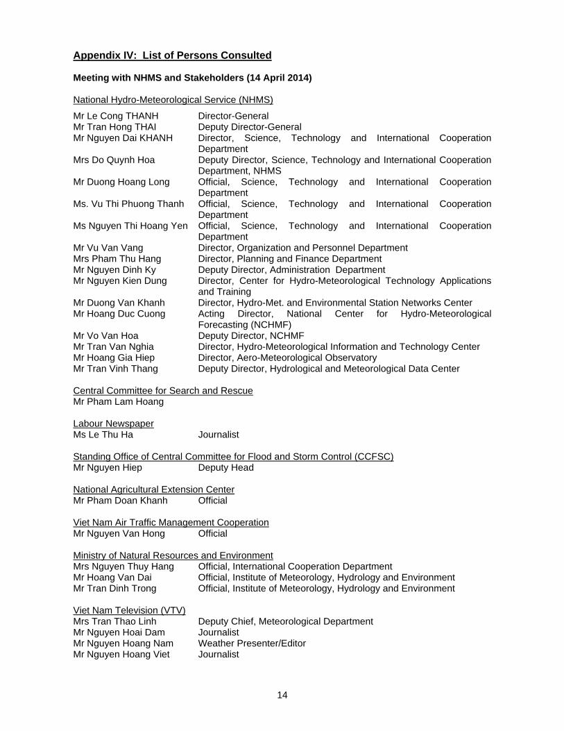
Appendix IV: List of Persons Consulted Meeting with NHMS and Stakeholders (14 April 2014) National Hydro-Meteorological Service (NHMS)
Mr Le Cong THANH Director-General Mr Tran Hong THAI Deputy Director-General Mr Nguyen Dai KHANH Director, Science, Technology and International Cooperation
Department Mrs Do Quynh Hoa Deputy Director, Science, Technology and International Cooperation
Department, NHMS Mr Duong Hoang Long Official, Science, Technology and International Cooperation
Department Ms. Vu Thi Phuong Thanh Official, Science, Technology and International Cooperation
Department Ms Nguyen Thi Hoang Yen Official, Science, Technology and International Cooperation
Department Mr Vu Van Vang Director, Organization and Personnel Department Mrs Pham Thu Hang Director, Planning and Finance Department Mr Nguyen Dinh Ky Deputy Director, Administration Department Mr Nguyen Kien Dung Director, Center for Hydro-Meteorological Technology Applications
and Training Mr Duong Van Khanh Director, Hydro-Met. and Environmental Station Networks Center Mr Hoang Duc Cuong Acting Director, National Center for Hydro-Meteorological
Forecasting (NCHMF) Mr Vo Van Hoa Deputy Director, NCHMF Mr Tran Van Nghia Director, Hydro-Meteorological Information and Technology Center Mr Hoang Gia Hiep Director, Aero-Meteorological Observatory Mr Tran Vinh Thang Deputy Director, Hydrological and Meteorological Data Center Central Committee for Search and Rescue Mr Pham Lam Hoang Labour Newspaper Ms Le Thu Ha Journalist Standing Office of Central Committee for Flood and Storm Control (CCFSC) Mr Nguyen Hiep Deputy Head National Agricultural Extension Center Mr Pham Doan Khanh Official Viet Nam Air Traffic Management Cooperation Mr Nguyen Van Hong Official Ministry of Natural Resources and Environment Mrs Nguyen Thuy Hang Official, International Cooperation Department Mr Hoang Van Dai Official, Institute of Meteorology, Hydrology and Environment Mr Tran Dinh Trong Official, Institute of Meteorology, Hydrology and Environment Viet Nam Television (VTV) Mrs Tran Thao Linh Deputy Chief, Meteorological Department Mr Nguyen Hoai Dam Journalist Mr Nguyen Hoang Nam Weather Presenter/Editor Mr Nguyen Hoang Viet Journalist

15
Meeting with National Center for Hydro-Meteorological Forecasting (NCHMF) (14 April 2014) Mr Vo Van Hoa Deputy Director Mr Nguyen Vinh Thu Head of Division, Numerical Weather Prediction and Remote Sensing Mr Nguyen Ba Thuy Head of Division, Marine Hydro-Meteorological Forecasting Division Mr Tran Quang Nang Deputy Head, Short-Range Meteorological Forecasting Division Mr Du Duc Tien Deputy Head, Numerical Weather Prediction and Remote Sensing Mr Nguyen Ba Thuy Chief, Marine Hydrometeorological Forecasting Department Meeting with the Central Committee for Flood and Storm Control (CCFSC) (15 April 2014) Mr Vu Kien Trung Deputy Director, Department of Dyke Management and Flood, Storm
Control (DDMFSC), and Deputy Director, Standing Official Central Committee for Flood and
Storm Control (CCFSC), Ministry of Agriculture and Rural Development (MARD) of DDMFSC
Mr Nguyen Van Luong Head, DDMFSC, MARD Mr Nguyen Hiep Deputy Head CCFSC, DDMFSC, MARD Mr Nguyen Duc Thang Official, DDMFSC, MARD Meeting with Viet Nam Television Weather and Disaster Broadcast Center (VTV-WDB) (15 April 2014) Ms Pham Thi Thanh Thu Director Ms Bui Hai Binh Deputy Director Ms Tran Thao Linh Deputy Chief of Meteorological Department Ms Hoang Thanh Van Head of Graphic Design Team, Meteorological Department Mr Phung Van Hieu Graphic designer, Meteorological Department Ms Nguyen Thi Hang Meteorologist/Editor, Meteorological Department Ms Bui Thi Thanh Thao Chief of Production Department, Producer/Reporter, Production
Department, Ms Nguyen Anh Thu Journalist, Weather presenter, Production Department Mr Dao Tuan Dung Reporter/Editor, interpreter, Production department Ms Nguyen Mai Ngoc Weather Presenter/Editor, Production department Mr Nguyen Hoang Nam Weather Presenter/Editor, Production Department Meeting with the JICA Office (16 April 2014) Dr Hirotada Matsuki JICA Expert (Disaster Risk Reduction) Ms Nguyen Thi Thu Le Program Officer
_____________

16
Appendix V: Best Track Data of Haiyan by RSMC Tokyo and the Storm Surge Height Prediction by NHMS
Strom surge height prediction by NHMS (8 November 2013)
_____________
17
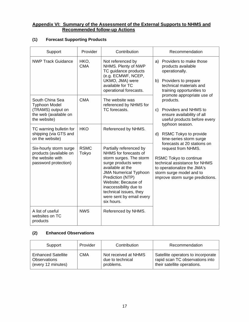
Appendix VI: Summary of the Assessment of the External Supports to NHMS and Recommended follow-up Actions
(1) Forecast Supporting Products
Support Provider Contribution Recommendation
NWP Track Guidance HKO, CMA
Not referenced by NHMS. Plenty of NWP TC guidance products (e.g. ECMWF, NCEP, UKMO, JMA) were available for TC operational forecasts.
a) Providers to make those products available operationally.
b) Providers to prepare
technical materials and training opportunities to promote appropriate use of products.
c) Providers and NHMS to
ensure availability of all useful products before every typhoon season.
d) RSMC Tokyo to provide
time-series storm surge forecasts at 20 stations on request from NHMS.
RSMC Tokyo to continue technical assistance for NHMS to operationalize the JMA’s storm surge model and to improve storm surge predictions.
South China Sea Typhoon Model (TRAMS) output on the web (available on the website)
CMA The website was referenced by NHMS for TC forecasts.
TC warning bulletin for shipping (via GTS and on the website)
HKO Referenced by NHMS.
Six-hourly storm surge products (available on the website with password protection)
RSMC Tokyo
Partially referenced by NHMS for forecasts of storm surges. The storm surge products were available at the JMA Numerical Typhoon Prediction (NTP) Website; Because of inaccessibility due to technical issues, they were sent by email every six hours.
A list of useful websites on TC products
NWS Referenced by NHMS.
(2) Enhanced Observations
Support Provider Contribution Recommendation
Enhanced Satellite Observations (every 12 minutes)
CMA Not received at NHMS due to technical problems.
Satellite operators to incorporate rapid scan TC observations into their satellite operations.

18
(3) Good Practices on Emergency Reponses
Support Provider Contribution Recommendation
A list of recommendations to NHMS
RSMC Tokyo
Used to double-check that NHMS's emergency responses were appropriate.
a) NHMS to review and, if appropriate, reflect, in cooperation with relevant DRR authorities, the provided recommendations and materials to its emergency operation plan during off-typhoon season.
b) WMO and TCS to increase the opportunities for Members to share best practices of, know-how on, and lessons learnt from past severe TC events during off- typhoon season.
Mitigation Measures & Good Practices, and Contingency Plan
HKO
National Disaster Response Plan
CMA
(4) Teleconferences
Support Provider Contribution Recommendation
Teleconferences with Guangzhou Regional Meteorological Centre (GRMC)
GRMC/ CMA
NHMS and GRMC, based on the bilateral agreement between CMA and NHMS, exchanged views on latest TC forecasts including landfall time, uncertainty of forecasts, and synoptic situations.
a) WMO and TCS to further enhance training activities for TC and storm surge forecasts.
b) RSMT of SWFDP-SeA, in cooperation with RFSC Hanoi and RSMC Tokyo, to find the most feasible implementation scheme, particularly on how to produce/share severe weather forecasting guidance in the region*.
*Options to be considered: a. To establish communication channels among the RSMC Tokyo, the RFSC Hanoi, and
participating Members, on request, in the case of extremely severe phenomena like Haiyan (within the framework of SWFDP-SeA).
b. To share national weather manual guidance among Members concerned. c. To share the responsibilities of the RFSC with other participating Member(s).
_____________

19
Appendix VII: Photos
Meeting with NHMS and partners, 14 April 2014
Meeting with VTV, 15 April 2014
Meeting with NHMS, 16 April 2014
_____________