Embed Size (px)
Citation preview

Replace this
figure
with your
harbour logo
PORT INFORMATION
GUIDE
ROTTERDAM AUGUST 2012
PORT INFORMATION GUIDE • Source: Harbour Master Port of Rotterdam • August 1 2012 2
INITIATED BY IN ASSOCIATION WITH SUPPORTED BY
PORT INFORMATION GUIDE • Source: Harbour Master Port of Rotterdam • August 1 2012 3
GENERAL INTRODUCTION This book has been written for Masters of seagoing vessels, shipping lines, publishers of nautical information and any other party that needs nautical information. LEGAL DISCLAIMER Port of Rotterdam makes every effort to make and maintain the contents of this document as up-to-date, accessible, error-free and complete as possible, but the correctness and completeness of these contents cannot be guaranteed. Port of Rotterdam accepts no liability whatsoever for the occurrence and/or consequences of errors, faults or incompleteness or any other omission in connection with the information provided by this document. In case of any discrepancies or inconsistencies between this document and the applicable legislation, including the port bye-laws, the latter will prevail. CONTACT PORT Havenbedrijf Rotterdam N.V., Rotterdam, is registered with the trade register in the Netherlands under no. 24354561 CONTACT PERSON FOR PORT INFORMATION Ben van Scherpenzeel – for all issues related to the Port Information Guide contents E [email protected] Or via Harbour Coordination Center (see chapter 2.2) for all other issues. WEBSITE OF THE PORT www.portofrotterdam.com WEBSITE OF THIS DOCUMENT http://www.portofrotterdam.com/en/Shipping/sea-shipping/port-information
PORT INFORMATION GUIDE • Source: Harbour Master Port of Rotterdam • August 1 2012 4
TABLE OF CONTENTS GENERAL INTRODUCTION 3 TABLE OF CONTENTS 4 RECORD OF CORRECTIONS 8 PART I INTRODUCTION, CONTACT INFORMATION AND REGULATIONS 1. FOREWORD HARBOUR MASTER 9
1.1 General 10 1.2 Port report 10 1.3 Port performance 11
2. CONTACT INFORMATION AND REGULATIONS 13
2.1 General 14 2.2 Contact information 14 2.3 Rules and regulations 15 2.4 Exemptions and permits 15 2.5 Recent important amendments to law 15
PART II NOTIFICATION, DOCUMENTATION AND REPORTING 3. ARRIVAL AND DEPARTURE CHECKLISTS 17
3.1 General 18 3.2 Arrival checklists 18 3.3 Departure checklists 19
4. NOTIFICATION 21
4.1 General 22 4.2 Health 22 4.3 Immigration 22 4.4 Customs 24 4.5 ETA 26 4.6 ETD 27 4.7 Security 28 4.8 Dangerous Goods 29 4.9 Waste 30
4.10 IOPP 31 4.11 Explanation of reporting codes 31
5. DOCUMENTATION 35
5.1 General 36 5.2 Required documentation, to be available at all times 36

PORT INFORMATION GUIDE • Source: Harbour Master Port of Rotterdam • August 1 2012 5
6. REPORTING 37
6.1 General 38 6.2 Issues to be reported 38
PART III PORT DESCRIPTION & NAVIGATION
7. PORT DESCRIPTION 39
7.1 General 40 7.2 Developments 40 7.3 Port location 40 7.4 Port limits 40 7.5 Load lines 41 7.6 Maximum size vessels 41 7.7 Time zone 41 7.8 Local holidays 41 7.9 Working hours 41
7.10 Traffic 41 7.11 Cargo 41 7.12 Charts and books 42 7.13 Shipping announcements for the port area 42 7.14 Pilot stations 42 7.15 Port infrastructure 42 7.16 Port accommodation and berths 47 7.17 Weather and tidal information 48 7.18 Webcams 51
8. PORT NAVIGATION 53
8.1 General 54 8.2 Speed 54 8.3 UKC 54 8.4 Right of way 55 8.5 Spacing of vessels 55 8.6 Passing arrangements 55 8.7 Restrictions 55 8.8 Inward bound vessels 56 8.9 Outward bound vessels 60
8.10 Shifting vessels 61 8.11 Docking 61 8.12 Display of signals and lights 62
PART IV PORT SAFETY & SECURITY
9. PORT SAFETY 63
9.1 General 64 9.2 Emergency contacts 64 9.3 Emergency response equipment 64

PORT INFORMATION GUIDE • Source: Harbour Master Port of Rotterdam • August 1 2012 6
9.4 Emergency coordination centre 65 9.5 Emergency scenarios 65
10. PORT SECURITY 67
10.1 General 68 10.2 Present ISPS security level information 68 10.3 Reporting to port facilites 68
PART V NAUTICAL SERVICES & COMMUNICATION
11. NAUTICAL SERVICES 69
11.1 General 70 11.2 VTS 70 11.3 Pilotage 73 11.4 Tugs 83 11.5 Mooring 85 11.6 Lashing of cargo 87
12. NAUTICAL COMMUNICATION 89
12.1 General 90 12.2 VHF channels nautical communication 90
PART VI PORT OPERATIONS
13. CARGO OPERATIONS 93
13.1 General 94 13.2 Loading/Discharging procedures 94 13.3 Cleaning procedures 95
14. VESSEL OPERATIONS 99
14.1 General 100 14.2 Lowering boats and rafts 100 14.3 Maintenance and repair 100 14.4 Underwater inspection/ cleaning 101
15. PORT INSPECTIONS 103
15.1 General 104 15.2 Inspections from Port State Control 104 15.3 Inspections from other parties 104
PART VII PORT SERVICES
16. PORT SERVICES 105
16.1 General 106 16.2 Fuel and lubrication oil 106
PORT INFORMATION GUIDE • Source: Harbour Master Port of Rotterdam • August 1 2012 7
16.3 Fresh water 107 16.4 Stores 107 16.5 Shore based electricity 107 16.6 Waste 108 16.7 Repairs 109 16.8 De-ratting 109 16.9 Surveyors 109
16.10 Shipping agents 109 16.11 Medical facilities 110 16.12 Seaman's Missions 110 16.13 Transport 110

PORT INFORMATION GUIDE • Source: Harbour Master Port of Rotterdam • August 1 2012 8
Record of corrections Date Page Correction subject Source 28/02/12 3 Naming HCC 28/02/12 10 Port report for 2011 28/02/12 11 Naming HCC 28/02/12 14 Naming HCC 28/02/12 22 Website name 28/02/12 38 Naming HCC 28/02/12 46 Storm surge barrier 28/02/12 48 Naming HCC 28/02/12 64 VTS channels and naming HCC 28/02/12 65 Emergency Coordination Center 28/02/12 66 Naming HCC 28/02/12 70 VTS navigational assistance 28/02/12 73 Naming HCC 28/02/12 83 Naming HCC 28/02/12 90 Naming HCC and VTS channels 28/02/12 100 Naming HCC 28/02/12 101 Naming HCC 28/02/12 106 Naming HCC 20/06/12 26 ÈTA reporting 20/06/12 27 ETD reporting 20/06/12 31 Draft reporting (item O) 20/06/12 79 Winch on starboard side of heli 20/06/12 86 Use of ETOPS 20/06/12 109 Ship agents 20/06/12 109 De-ratting 20/06/12 110 Seaman’s Missions 13/07/12 26 Telex deleted 13/07/12 81 Wording of SBP changed 13/07/12 109 Ship agents 01/08/12 55 Maximum draught on departure

1 Foreword Harbour Master
PORT OF ROTTERDAM
PART I | 1. FOREWORD HARBOUR MASTER
PORT INFORMATION GUIDE • Source: Harbour Master Port of Rotterdam • August 1 2012 10
1.1 GENERAL Welcome to the port of Rotterdam, the main port of Europe, stretching from the North Sea approach area over a length of 40 km further inland. This is the area of which I, as the Chief Harbour Master, am in charge – 24 hours a day, 7 days a week - of the public nautical and maritime tasks. As it is my responsibility to ensure a smooth, safe, environmentally friendly and secure shipping handling, I see it as a personal challenge that the Master of every vessel calling at the Port of Rotterdam finds his visit trouble-free and enjoyable. In the Port of Rotterdam, the nautical maritime authority functions have been integrated into one person, the Chief Harbourmaster. This integration of functions aims explicitly to make your call as good as possible. The background is the Harbourmaster’s Covenant, a formal agreement between the national government, the city government of Rotterdam and the Port of Rotterdam Authority which gives me as Chief Harbourmaster an autonomous position within the Port Authority. Based on the Covenant, I am also State Harbourmaster in the region Rotterdam-Rijnmond, carrying with it the control over the waterways into the various harbours. Furthermore I am mandated in this region as Port Security Authority. The port of Rotterdam is well known for its high standards of nautical services, the safe and smooth handling of shipping and a Vessel Traffic Guidance System of high quality. The staff of my Division Harbour Master of the port authority contributes a great deal to these high standards with its over 510 specialists, 10 patrol vessels and 100% radar coverage. The Division Harbour Master also puts great effort in drawing up clear port procedures and regulations. Subsequently it supervises strictly the observance of these regulations. Over the years, the perception has grown that a vessel in the port of Rotterdam must have her things in order. Shipping companies that invest in safety and environment appreciate this attitude, as it allows them to operate faster and cheaper. At the same time Rotterdam is a port where, whenever necessary, every ship receives special attention and active co-operation in order to find optimal solutions, of course within the law and environmental boundaries. As far as enforcement is concerned, it is our firm believe that preventive action by means of direct information and support - given on board by our inspectors, by the crews of our patrol vessels and by our VTS operators - is the best way to prevent problems with safety and environment. This reduces to a large extent the necessity for more stringent enforcement
1.2 PORT REPORT With 35.000 seagoing vessels and 133.000 inland vessels visiting us each year, the port of Rotterdam is characterized as having dense shipping traffic. Within the regional port area, cargo sea ship movements are over 90.000, while inland ship movements amount to 400.000 each year. Annually 430 million tons of goods are handled (in 2011), of which more than 110 million tons of IMO classified dangerous goods. The maximum draught is 22.55 meters, there are no locks. Situated at the end of the river Rhine, locally known as the Nieuwe Waterweg, the port has a position at the gateway of the European inland waterway network, making the port of Rotterdam ideally located for the transhipment of cargo. The extensive industrial complex and its strategic location in Europe, make that most major carriers include Rotterdam in their services. Containers destined for other European countries are forwarded from Rotterdam by

PORT OF ROTTERDAM
PART I | 1. FOREWORD HARBOUR MASTER
PORT INFORMATION GUIDE • Source: Harbour Master Port of Rotterdam • August 1 2012 11
feeder services, inland vessels, railway or trucks. The port of Rotterdam is well equipped for handling bulk and general cargoes, coal and ores, crude oil, LNG, bio fuels, agricultural products, chemicals, containers, cars, fruit, refrigerated cargoes etc. Developments are always in progress within the Division Harbour Master and some are worthwhile mentioning: The programme ’VTM Future’ will further upgrade and improve the quality of the Vessel Traffic Management and Information Services. This programme will ensure an unhindered and smooth passage of shipping in the future, when traffic density, traffic patterns and ships dimensions increase further. The Harbour Master’s Coordination Center (HCC) of the port authority receives and handles all operational maritime requests, questions, messages and reports. Electronic notifications via EDI and/or internet are made available in order to send cargo information and notifications to the Harbour Master. Constant co-operation with all inspection services in the port should minimize the inspection pressure on vessels. Innovations to the enforcement strategy are introduced, for example by making more use of risk analyses. The Port of Rotterdam Authority constructs Maasvlakte 2. With Maasvlakte 2, Rotterdam offers 1000 hectares of sites that will become available for deep-sea related container handling, distribution, chemicals and new industry. In 2013 the first ships are to be received.
1.3 PORT PERFORMANCE The Port of Rotterdam Authority uses performance indicators to measure, on a monthly basis, its own performance levels. One of them is the dynamic Turn Around Time (TAT), measuring the sailing time of each sea-going vessel to the port, starting from Maascenter buoy to the port clusters Europoort, Botlek and City. Notwithstanding the increased transhipments of cargo, the turn around time has not been negatively effected. However, if there is any indication that the TAT will increase, an investigation is launched and possible measures are called for. The number of nautical incidents in the port shows a steady decline over the last years. Considering the huge amount of traffic movements (around 1 million), Rotterdam can certainly be considered a very safe port. What’s more, the incidents that did happen were mostly without major consequences. Nevertheless, every incident is always analyzed in order to learn why it happened and where deemed necessary, measures will be taken. When any disruption like fires, collisions or spills appeared in the past, the Division Harbour Master was able to limit the delay to the shipping traffic, by quickly gaining control. Now you know why I am proud of our port and I am convinced that when you call at our port, you will have a pleasant experience dealing with our Division Harbour Master; the contemporary, ambitious, knowledgeable authority and host of the port of Rotterdam. Rene de Vries Harbour Master of the port of Rotterdam State Harbour Master in the region Rotterdam-Rijnmond


2 Contact information and regulations

PORT OF ROTTERDAM
PART I | 2. CONTACT INFORMATION AND REGULATIONS
PORT INFORMATION GUIDE • Source: Harbour Master Port of Rotterdam • August 1 2012 14
2.1 GENERAL The Harbour Master’s Office (the Division Harbour Master of the Port of Rotterdam Authority) is located in the continuously manned Harbour Coordination Center, at harbour number 1247, near the Holland Amerika quay. Visiting address: Wilhelminakade 909, 3072 AP Rotterdam Postal address: P.O. Box 6622, 3002 AP Rotterdam
2.2 CONTACT INFORMATION Within the Harbour Master’s Division the relevant operational departments are: HARBOUR COORDINATION CENTER (HCC) The Harbour Coordination Center has been established in order to centrally receive and handle all operational maritime requests, questions, messages and reports. The Harbour Coordination Center is continuously manned, and is primarily responsible for the safety of traffic and navigation in the harbour basins and main waterways. Its tasks include planning and control of shipping traffic, assigning berths in the entire port area, enforcing Port Bye-laws and other regulations, patrolling the entire port area and keeping traffic ways clear and coordinating information on all traffic movements. This department executes the port’s admission policy. The VTS stations provide all the necessary information regarding positions of ships etc. INSPECTIONS Inspections Department is a continuously manned bureau which carries out the administration of the dangerous cargo reports, supplies information about dangerous cargo, and supervises the loading and discharging of dangerous goods. The bureau also maintains discharge records of waste products of vessels, delivered to the port reception facilities in the port of Rotterdam. They can be reached via Harbour Coordination Center.
For operational maritime questions, messages, reports and repairs etc. please contact the Harbour Coordination Center (HCC) Contacting Harbour Coordination Center (HCC): Telephone: +31 10 252 10 00 Fax: +31 10 252 16 00 e-Mail: [email protected] VHF channel 14
For notifications (ETA/ETD ships etc.), requests for tidal windows, multi buoy mooring and other reports such as port security, spills, emergencies etc: please contact Harbour Coordination Center Contacting Harbour Coordination Center (HCC): Telephone: +31 10 252 1000 Fax: +31 10 252 1600 e-Mail: [email protected] VHF channel 19

PORT OF ROTTERDAM
PART I | 2. CONTACT INFORMATION AND REGULATIONS
PORT INFORMATION GUIDE • Source: Harbour Master Port of Rotterdam • August 1 2012 15
2.3 RULES AND REGULATIONS The rules and regulations in the port contribute to the safe, efficient and environmentally responsible handling of shipping traffic. The international rules of the IMO, such as the SOLAS convention and its amendments (e.g. the IMDG code and IBC) and national regulations, including the recommendations of the European Community, are in force in the port of Rotterdam. Furthermore, the Port Bye-laws are the "house rules" of the port. Based on the Rotterdam Port Bye-laws, the Port Rules on dangerous substances contain additional, specific regulations for ships carrying dangerous cargoes in the port. The Shipping Announcements inform you about all activities in the port and amendments to the regulations. An overview of the Shipping Announcements can be found on www.portofrotterdam.com/en/shipping/up-to-date/Bekendmakingen/ APPLICABLE REGULATIONS Shipping Traffic Act Inland Navigation Police Regulations (BPR) Shipping Regulations for Territorial Waters (STZ) Compulsory Pilotage Decree 1995 Decree on Pilot Exemption Certificate Holders Shipping Traffic Act Regulation for Licensed (Maritime) Pilots Regulation for the Prevention of Pollution from Ships Regulation on the Transportation of Dangerous Substances, 2007 Port Bye-laws Rotterdam 2004 – updated for 2007 Port Bye-laws Schiedam and Vlaardingen Regulation for Communication and Pilot requests seashipping Port Security Law (ISPS)
2.4 EXEMPTIONS AND PERMITS The Harbour Master can grant exemptions from specific regulations. Permission can also be granted for special activities such as repairs and cleaning. Contact the Harbour Coordination Center. Forms can be downloaded from www.portofrotterdam.com/en/Shipping/contact-support/Pages/forms-checklists.aspx
2.5 RECENT IMPORTANT AMENDMENTS TO LAW Please consult our website: www.portofrotterdam.com/en/Shipping/rules-regulations/Pages/regulations.aspx

3 Arrival and Departure Checklists
PORT OF ROTTERDAM
PART II | 3. ARRIVAL AND DEPARTURE CHECKLISTS
PORT INFORMATION GUIDE • Source: Harbour Master Port of Rotterdam • August 1 2012 18
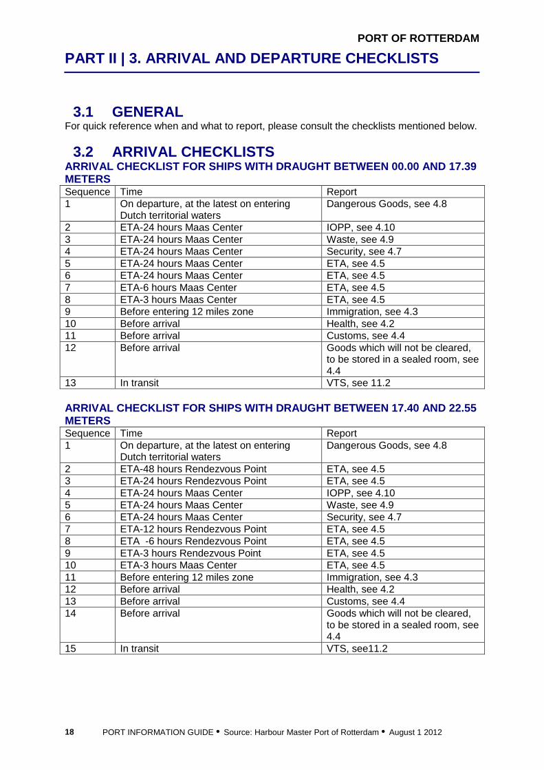
3.1 GENERAL For quick reference when and what to report, please consult the checklists mentioned below.
3.2 ARRIVAL CHECKLISTS ARRIVAL CHECKLIST FOR SHIPS WITH DRAUGHT BETWEEN 00 .00 AND 17.39 METERS Sequence Time Report 1 On departure, at the latest on entering
Dutch territorial waters Dangerous Goods, see 4.8
2 ETA-24 hours Maas Center IOPP, see 4.10 3 ETA-24 hours Maas Center Waste, see 4.9 4 ETA-24 hours Maas Center Security, see 4.7 5 ETA-24 hours Maas Center ETA, see 4.5 6 ETA-24 hours Maas Center ETA, see 4.5 7 ETA-6 hours Maas Center ETA, see 4.5 8 ETA-3 hours Maas Center ETA, see 4.5 9 Before entering 12 miles zone Immigration, see 4.3 10 Before arrival Health, see 4.2 11 Before arrival Customs, see 4.4 12 Before arrival Goods which will not be cleared,
to be stored in a sealed room, see 4.4
13 In transit VTS, see 11.2 ARRIVAL CHECKLIST FOR SHIPS WITH DRAUGHT BETWEEN 17 .40 AND 22.55 METERS Sequence Time Report 1 On departure, at the latest on entering
Dutch territorial waters Dangerous Goods, see 4.8
2 ETA-48 hours Rendezvous Point ETA, see 4.5 3 ETA-24 hours Rendezvous Point ETA, see 4.5 4 ETA-24 hours Maas Center IOPP, see 4.10 5 ETA-24 hours Maas Center Waste, see 4.9 6 ETA-24 hours Maas Center Security, see 4.7 7 ETA-12 hours Rendezvous Point ETA, see 4.5 8 ETA -6 hours Rendezvous Point ETA, see 4.5 9 ETA-3 hours Rendezvous Point ETA, see 4.5 10 ETA-3 hours Maas Center ETA, see 4.5 11 Before entering 12 miles zone Immigration, see 4.3 12 Before arrival Health, see 4.2 13 Before arrival Customs, see 4.4 14 Before arrival Goods which will not be cleared,
to be stored in a sealed room, see 4.4
15 In transit VTS, see11.2

PORT OF ROTTERDAM
PART II | 3. ARRIVAL AND DEPARTURE CHECKLISTS
PORT INFORMATION GUIDE • Source: Harbour Master Port of Rotterdam • August 1 2012 19
3.3 DEPARTURE CHECKLISTS DEPARTURE CHECKLIST FOR SHIPS WITH DRAUGHT LESS THA N 17.40 METERS Sequence Time Report 1 ETD-6/-3 hours Immigration, see 4.3 2 ETD-3 hours ETD, see 4.6 3 ETD-3 hours Dangerous goods, see 4.8 4 Prior to departure Customs, see 4.4 5 On departure Actual departure, see 4.6 and
11.2 6 In transit VTS, see 11.2 DEPARTURE CHECKLIST FOR SHIPS WITH DRAUGHT BETWEEN 17.40 AND 22.55 METERS Sequence Time Report 1 ETD-12 hours ETD, see 4.6 2 ETD-6/ -3 hours Immigration, see 4.3 3 ETD-3 hours ETD, see 4.6 4 ETD-3 hours Dangerous goods, see 4.8 5 Prior to departure Customs, see 4.4 6 On departure Actual departure, see 4.6 and
11.2 7 In transit VTS, see 11.2


4 Notification
PORT OF ROTTERDAM
PART II | 4. NOTIFICATION
PORT INFORMATION GUIDE • Source: Harbour Master Port of Rotterdam • August 1 2012 22
4.1 GENERAL Masters of vessels arriving at, staying in or departing from the port of Rotterdam are obliged to make previous notification on a variety of subjects, ranging from health to immigration to dangerous goods. This section lists all the requirements for notifying the port authorities.
4.2 HEALTH Source: Municipal Health Service (GGD) of Rotterdam PRIOR TO ARRIVAL The master has to complete and sign a Maritime Declaration of Health. The standard international form has to be used. To download this form: www.portofrotterdam.com/en/Shipping/rules-regulations/port-health-authority/Pages/maritime-declaration-health.aspx In case one of these questions has been answered by ‘yes’, or in case of other quarantine problems:
• advise the pilot, the ship agent and HCC • mail or fax this form to [email protected] or fax this form to 010 – 252 1600 • keep the person responsible for medical care on board, to answer any questions
In all cases keep the Maritime Declaration of Health form stand-by. In case of an epidemic threat the master can be requested to report the health situation on board to Vessel Traffic and Operations (see Chapter 2)
4.3 IMMIGRATION Source: Rotterdam-Rijnmond Seaport Police (responsible for Immigration) GENERAL In the circumstances where the provisions of the Aliens Act (regulations pertaining to foreigners) fail to be complied with, the persons to be held responsible may be reported. PRIOR TO ARRIVAL On entering the Netherlands territory (12 nautical mile zone) the Master of a seagoing vessel must immediately:
• forward a Crew and Passenger list (IMO FAL form no. 5 and 6) • report the presence of any stowaways
The foregoing implies that the Seaport Police must be in possession of the required information prior to the arrival of the seagoing vessel in the port of Rotterdam. Submit the data to or download the crew manifest program from the Rotterdam-Rijnmond Seaport Police (see contact information below).

PORT OF ROTTERDAM
PART II | 4. NOTIFICATION
PORT INFORMATION GUIDE • Source: Harbour Master Port of Rotterdam • August 1 2012 23
AFTER DOCKING THE VESSEL Despite the fact that the crew manifest and the possible passenger manifest will have been forwarded in advance, Seaport Police officials will regularly come on board to carry out a physical inspection for border control purposes after the seagoing vessel has docked. During an inspection of this kind, the Master must present the crew manifest and possible passenger manifest to the officials, and offer his full co-operation during the inspection. The Seaport Police aims to carry out the inspection within 6 hours of the vessel’s arrival in port. WHILE IN THE NETHERLANDS Throughout the entire period that his vessel is docked in a Dutch port, the Master of a seagoing vessel entering the Netherlands is obliged to:
• retain in his safekeeping the copy of the crew manifest returned to him by the border control official after being checked, and to submit this for inspection immediately if summoned to do so
• report every signing-on by an alien citizen, or the absence of any alien citizen who is a vessel crew member that may be deemed important from the point of view of border control or supervision of aliens
• duly report any intention of an alien crew member to sign off • duly report the departure or boarding of aliens who do not belong to the crew (i.e.
passengers) CREW MEMBERS WHO WISH TO GO ASHORE Any aliens entering the Netherlands as the Master or crew member of a seagoing vessel may be admitted. Admission will only be granted if the Master or crew member complies with the requirements that are in place for border control purposes, to wit:
• a physical on board inspection has been carried out • permission has been obtained from the checkpoint officials • six hours have elapsed since the vessel passed Hook of Holland
If the alien is not in the possession of a valid document for border crossing, the alien will solely be granted entry to the municipality in which the vessel is docked and the adjacent municipalities. If seamen wish to gain admission to other municipalities, they are required to carry a document authorizing the crossing of borders (plus a visa, if necessary). PASSENGERS Passengers who do not need a visa can request for admission. On board they will be checked and their documents will be stamped Passengers who do need a visa must request this visa in their home country. Without a visa they are not allowed to disembark PASSENGERS WHO ARE RELATED TO A CREW MEMBER Passengers who can show evidence that they have a relationship with a crew member, can get a visa so they can go ashore together. DEPARTURE FROM THE NETHERLANDS A Master of a seagoing vessel shall duly notify the head of the checkpoint through which his vessel will be passing, of the intended departure of his vessel from the Netherlands.
PORT OF ROTTERDAM
PART II | 4. NOTIFICATION
PORT INFORMATION GUIDE • Source: Harbour Master Port of Rotterdam • August 1 2012 24
Such notification shall be made: • no more than six and no less than three hours prior to the actual departure of the
vessel • in the event the vessel remains at the relevant location for less than three hours, in
sufficient time as to grant the checkpoint official opportunity to carry out the required inspection of persons
At the departure of a seagoing vessel, the Seaport Police strives to come on board before concluding the border control formalities. CHECKPOINT Rotterdam-Rijnmond Seaport Police St Jobsweg 6 3024 EJ ROTTERDAM Telephone: +31 10 274 74 71 Fax: +31 10 275 01 21 e-Mail: [email protected] www.dutch-immigration.nl (download crew manifest program)
4.4 CUSTOMS Source: Dutch Customs PRIOR TO ARRIVAL DOCUMENTS The following documents must be available:
• cargo-statements (e.g. bills of lading) • crew’s effects declaration (IMO FAL form no. 4) • vessel’s stores declaration (IMO FAL form no. 3)
It is strongly recommended that these papers are at hand before arrival in port. BONDED STORE Goods, which are not to be cleared, must be stored in one room, which room can be sealed by Customs. It is recommended to put these goods in that room before entering the harbour. Masters of ships must be careful that these seals are not damaged. If renewal or removal is wanted, this can be applied by Customs. CUSTOMS ALLOWANCES ON PROVISIONS Spirits: ¼ liter per crew member with a maximum of 5 litres per vessel Wine: 5 litres per crew member Tobacco products: either 200 cigarettes, or 25 cigars, or 500 grams of tobacco out of bond per crew member for use on board PROVISION QUANTITIES The quantity of provisions allowed to be used during the stay in port, is based on a standard of one week.

PORT OF ROTTERDAM
PART II | 4. NOTIFICATION
PORT INFORMATION GUIDE • Source: Harbour Master Port of Rotterdam • August 1 2012 25
If the stay in port requires more than one week, a new allotment for the remaining days may be acquired on application to Customs. When a vessel is no longer active (e.g. discharging or loading), Customs will not allow a new allotment. BEING WITHIN DUTCH TERRITORIAL WATERS As long as an incoming vessel is within Dutch territorial waters (12 nautical mile zone) and has not been cleared by Dutch Customs, it is strictly forbidden:
• to allow any person to board the ship • to allow any member of the crew or passengers to disembark • to load or unload any goods • to allow contact with any other craft
The following persons are exempted from these rules:
• commissioned and licensed pilots • Harbour Master's representatives • customs officers • agents in possession of special permits • personnel on tugs employed in assisting the vessel
The same prohibition rules for outgoing vessels, even after clearance by Dutch Customs, for as long as these outgoing vessels are within Dutch territorial waters. Masters failing to comply with this regulation are liable to be prosecuted. PRIOR TO DEPARTURE A vessel is not allowed to proceed to sea without having obtained a clearance certificate from Customs (IMO FAL form no. 1). It is strictly forbidden to break Customs seals on bonded stores for as long as the vessel is within Dutch territorial waters. In case of detention within territorial waters, an application can be made for a Dutch Customs officer to board the vessel. This officer can release the needed goods and seal off the lockers again. MORE INFORMATION More information on Customs is available on the Dutch Customs website: douane.nl/english/

PORT OF ROTTERDAM
PART II | 4. NOTIFICATION
PORT INFORMATION GUIDE • Source: Harbour Master Port of Rotterdam • August 1 2012 26
4.5 ETA
Who What * To How When Remarks All ships with a draught of 17.40 meters or more
A, B, G, I, J, O, P, Q, T1, T2, U, W, X1, X2, X3, X4, X5
Harbour Master Rotterdam
Electronic Data Interchange (EDI*) as indicated by the Harbour Master
ETA-48 hours rendezvous point (51°59.0’N, 003°00.0’E)
Noxious and dangerous goods that have already been reported need to be reported only on request Changes of more than 30 minutes have to be reported in the same way
LNG carriers Same Same Same ETA – 48 hours to Maas Center
Same
All ships with a draught of less than 17.40 meters, except ships with a gross tonnage of less than 300 and LNG carriers
A, B, G, I, J, O, P, Q, T1, T2, U, W, X1, X2, X3, X4, X5
Harbour Master Rotterdam
Electronic Data Interchange (EDI*) as indicated by the Harbour Master
ETA- 24 hours Maas Center buoy or, if departure from a port was within these 24 hours, as soon as possible
Noxious and dangerous goods that have already been reported need to be reported only on request Changes of more than 30 minutes have to be reported in the same way
All ships with a draught of less than 17.40 meters, except ships with a gross tonnage of less than 300 and LNG carriers
A, B, I, O, Q
Harbour Master Rotterdam
e-mail: [email protected] Fax: +31 10 592 57 67
ETA- 6 hours Maas Center buoy
Changes of more than 30 minutes have to be reported in the same way
All ships, except ships with a gross tonnage of less than 300
A, D, I, O, Q
Sector Maas Approach
VHF channel 01 Calling in point Maas Aanloop
None
See list “Explanation of reporting codes ”
PORT OF ROTTERDAM
PART II | 4. NOTIFICATION
PORT INFORMATION GUIDE • Source: Harbour Master Port of Rotterdam • August 1 2012 27
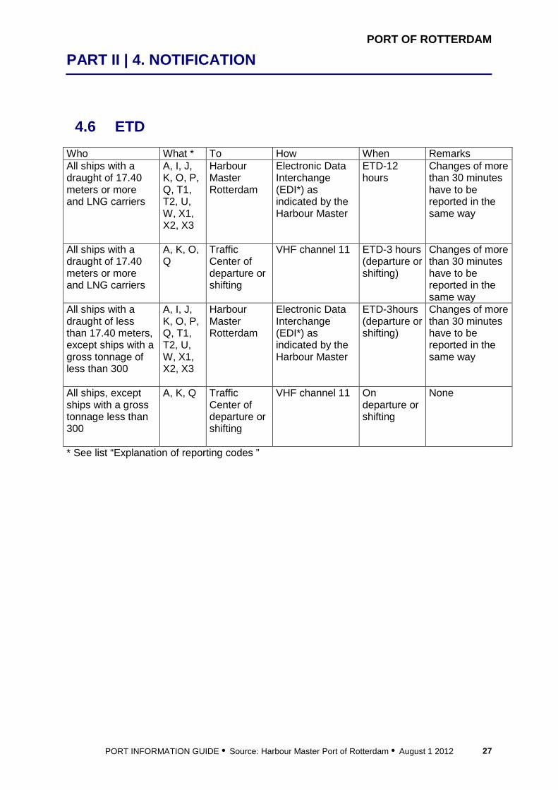
4.6 ETD Who What * To How When Remarks All ships with a draught of 17.40 meters or more and LNG carriers
A, I, J, K, O, P, Q, T1, T2, U, W, X1, X2, X3
Harbour Master Rotterdam
Electronic Data Interchange (EDI*) as indicated by the Harbour Master
ETD-12 hours
Changes of more than 30 minutes have to be reported in the same way
All ships with a draught of 17.40 meters or more and LNG carriers
A, K, O, Q
Traffic Center of departure or shifting
VHF channel 11 ETD-3 hours (departure or shifting)
Changes of more than 30 minutes have to be reported in the same way
All ships with a draught of less than 17.40 meters, except ships with a gross tonnage of less than 300
A, I, J, K, O, P, Q, T1, T2, U, W, X1, X2, X3
Harbour Master Rotterdam
Electronic Data Interchange (EDI*) as indicated by the Harbour Master
ETD-3hours (departure or shifting)
Changes of more than 30 minutes have to be reported in the same way
All ships, except ships with a gross tonnage less than 300
A, K, Q Traffic Center of departure or shifting
VHF channel 11 On departure or shifting
None
* See list “Explanation of reporting codes ”

PORT OF ROTTERDAM
PART II | 4. NOTIFICATION
PORT INFORMATION GUIDE • Source: Harbour Master Port of Rotterdam • August 1 2012 28
4.7 SECURITY Who What * To How When Remarks All commercial vessels with a gross tonnage of 500 tons or more and passenger ships
X6 Harbour Master Rotterdam
Electronic Data Interchange (EDI*) as indicated by the Harbour Master
ETA-24 hours Maas Center buoy (52°00.9’N, 003°48.8’E, as of 11/05/09)
Only ships that are under way to a port or anchorage in the Netherlands as part of an international voyage. The following ships do not have to report X6: -warships and troop transporting ships -ships without propulsion -wooden ships with primitive construction -fishing vessels
* See list “Explanation of reporting codes ”
PORT OF ROTTERDAM
PART II | 4. NOTIFICATION
PORT INFORMATION GUIDE • Source: Harbour Master Port of Rotterdam • August 1 2012 29
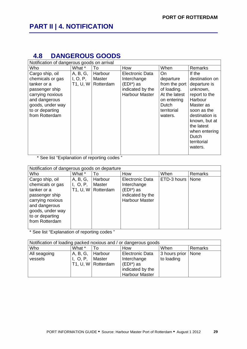
4.8 DANGEROUS GOODS Notification of dangerous goods on arrival Who What * To How When Remarks Cargo ship, oil chemicals or gas tanker or a passenger ship carrying noxious and dangerous goods, under way to or departing from Rotterdam
A, B, G, I, O, P, T1, U, W
Harbour Master Rotterdam
Electronic Data Interchange (EDI*) as indicated by the Harbour Master
On departure from the port of loading. At the latest on entering Dutch territorial waters.
If the destination on departure is unknown, report to the Harbour Master as soon as the destination is known, but at the latest when entering Dutch territorial waters.
* See list “Explanation of reporting codes ”
Notification of dangerous goods on departure Who What * To How When Remarks Cargo ship, oil chemicals or gas tanker or a passenger ship carrying noxious and dangerous goods, under way to or departing from Rotterdam
A, B, G, I, O, P, T1, U, W
Harbour Master Rotterdam
Electronic Data Interchange (EDI*) as indicated by the Harbour Master
ETD-3 hours None
* See list “Explanation of reporting codes ” Notification of loading packed noxious and / or dangerous goods Who What * To How When Remarks All seagoing vessels
A, B, G, I, O, P, T1, U, W
Harbour Master Rotterdam
Electronic Data Interchange (EDI*) as indicated by the Harbour Master
3 hours prior to loading
None

PORT OF ROTTERDAM
PART II | 4. NOTIFICATION
PORT INFORMATION GUIDE • Source: Harbour Master Port of Rotterdam • August 1 2012 30
Who All combination carriers What With respect to a combination carrier that is unloaded or loaded with loose bulk cargo in a solid form, not only shall reports be made in connection with the regular reporting, but the following information shall also be provided to the harbour master:
• the type of cargo • the type of transfer • the berth • the name of the product last transported as liquid cargo • the date on which the last shipment of liquid cargo was discharged • the stowage of (possible) cargo residues of combustible liquids • the percentage of oxygen in the inerted tank atmosphere, above the cargo residues
referred to under f • the data on the gasfree, non-gasfree or inert atmosphere of all other spaces within
the cargo zone. To Harbour Master How Via fax or e-mail to Harbour Coordination Center, see chapter 2 When Prior to arrival
4.9 WASTE Who What * To How When Remarks All ships Name, call sign,
IMO#, flag, ETA, ETD, last and next port of call, last port and date where waste has been landed Do you land all / some / no waste at the harbour reception facilities? Fill out waste report form (can be downloaded from http://www.portofrotterdam.com/en/Shipping/contact-support/Pages/forms-checklists.aspx
Harbour Master Rotterdam
Electronic Data Interchange (EDI*) as indicated by the Harbour Master
ETA- 24 hours Maas Center buoy (52°00.9’N, 003°48.8’E, as of 11/05/09) or, if departure from a port was within these 24 hours, as soon as possible
None
See list “Explanation of reporting codes ”

PORT OF ROTTERDAM
PART II | 4. NOTIFICATION
PORT INFORMATION GUIDE • Source: Harbour Master Port of Rotterdam • August 1 2012 31
4.10 IOPP Who What * To How When Remarks All oil tankers with a gross tonnage of 150 tons or more
X7 Harbour Master Rotterdam
Electronic Data Interchange (EDI*) as indicated by the Harbour Master
ETA-24 hours Maas Center buoy (52°01.1’N, 003°53.5’E)
None
* See list “Explanation of reporting codes ” Consult the website www.portofrotterdam.com/en/Shipping/rules-regulations/Pages/regulations.aspx for the new regulations on single hull tankers.
4.11 EXPLANATION OF REPORTING CODES A Ship
Name, call sign or ship station identity (IMO or MMSI number) and flag
B Date and time of event A six digit group giving day of month (first two digits), hours and minutes (last four digits) in UTC
C Position A four digit group giving latitude in degrees and minutes suffixed with N (north) or S (south) and a five digit group giving longitude in degrees and minutes suffixed with E (east) or W (west)
D Position True bearing (first three digits) and distance (state distance) in nautical miles from a clearly identified landmark (state landmark)
G Port of departure Name of last port of call I Destination and estimated time of
arrival Name of port and date time group expressed as in (B) (ETA pilot station)
J Pilot State whether a deep sea or local pilot is on board or one is requested
K Date, Time and point exit from system
Departure time expressed as in (B)
L Route information Intended track O Maximum present static draught in
metres A four digit group giving metres and centimeters On arrival: please report draft in 1025 On departure: please report draft alongside and in 1025

PORT OF ROTTERDAM
PART II | 4. NOTIFICATION
PORT INFORMATION GUIDE • Source: Harbour Master Port of Rotterdam • August 1 2012 32
P Cargo on board Nature of cargo and, if cargo consists of harmful and dangerous substances: the correct technical names the UN identification numbers and if applicable the IMO danger classification in accordance with the IMDG, IBC and IGC codes the ship’s class in accordance with the INF code the quantity of the dangerous goods and their location on board and their identification numbers if they are located in transport units suitable for cargo transport, except tanks. Confirmation that a list or manifest or an appropriate loading plan is on board, containing detailed information regarding the dangerous and noxious goods carried and their location on board Confirmation that a list or manifest or cargo plan is on board, accurately specifying the harmful or dangerous goods the ship is carrying and their location on the ship If the hold of a ship has been fumigated with a gaseous fumigant, also report: the nature of the cargo the chemical or technical name of the fumigant the disinfected spaces or the place of stowage of the disinfected cargo the date of treatment with disinfecting agents spaces that have been ventilated with air after treatment with disinfecting agents the presence of appropriate gas detectors on board for measuring concentrations of disinfecting gases and whether spaces have been checked before arrival for the presence of disinfecting gases, mentioning the spaces and measured value in parts per million
Q Defects, damage, deficiencies, limitations
Brief details of defects, damage, deficiencies, or other limitations
T1 Ship’s representative Name, address and phone number of the ship’s agent, captain, or operator
T2 Ship’s representative Name of customer U Ship size and type Details of length, breadth, tonnage (GT) and type W Total number of persons on board Total number of crew on board and the total
number of persons on board X1 Miscellaneous Presence of bow/stern thruster including capacity
in kW, radar, gyro compass, VHF with VTS channels of VTS area you will be passing, manoeuvring speed in knots
X2 Miscellaneous Report any changes in previous report X3 Miscellaneous Required tugboats or linesmen X4 Miscellaneous What is the purpose of your visit (e.g. loading,
discharging, or repair)

PORT OF ROTTERDAM
PART II | 4. NOTIFICATION
PORT INFORMATION GUIDE • Source: Harbour Master Port of Rotterdam • August 1 2012 33
X5 Miscellaneous Any other information that might be important X6 Miscellaneous Does the ship possess a valid International Ship
Security Certificate: yes or no Current security level Name of Ship Security Officer Authority that issued the ISPS certificate Of the last 10 ports of call, mention per port: Name of port Date of arrival and date of departure Ship security level Special or additional security measures taken by ship Remarks: Appropriate ship security procedures maintained during ship-to-ship activities during the last 10 port calls: yes or no Mention if you require any security measures at the port facility Other practical or security-related information (including ship-to-ship operations) Is the ship capable of executing the Ship Security Plan: yes or no Remark: Only ships that are underway to a port or anchorage in the Netherlands as part of an international voyage. This part does not have to be reported by warships and troop transporting vessels, ships without propulsion, wooden ships of primitive construction and fishing vessels
X7 Miscellaneous Place on the attached list a copy of the International Oil Pollution Prevention Certificate (IOPP Certificate)
Explanation of EDI: When EDI is mentioned the Master should issue all relevant info to his local representative (ship agent, see section 16.10). He/she will transfer this info as EDI standard message, and forward this message to the Harbour Master on behalf of the Master

5 Documentation

PORT OF ROTTERDAM
PART II | 5. DOCUMENTATION
PORT INFORMATION GUIDE • Source: Harbour Master Port of Rotterdam • August 1 2012 36
5.1 GENERAL The Port of Rotterdam Authority places importance on complying with rules and regulations. Therefore the vessel could be subject to inspection by inspectors of the Transport and Environmental Safety Department or Port State Control. Because port operations take place around the clock, these inspections take place during day- and nighttime. Our experience has learned that on many occasions, especially during the night, documentation or certificates were not available. To ensure a smooth operation, we advise to keep the following documentation and certificates (or certified copies of certificates) available at all times.
5.2 REQUIRED DOCUMENTATION, TO BE AVAILABLE AT ALL TIMES
FOR GENERAL CARGO VESSEL/BULK CARRIER: • IOPP • SOPEP • Garbage record book • Oil record book part I • Document of Compliance (in respect to dangerous goods) • Dangerous goods manifests and detailed stowage plan arrival and departure
Rotterdam • Documentation regarding fumigant used to fumigate bulk cargoes
FOR OIL/CHEMICAL/GAS TANKERS:
• IOPP • SOPEP • Shipboard marine pollution emergency plan • Garbage record book • Oil record book part I and II • Certificate of Fitness chemical/gas, including product list • Procedures and arrangements manual • Cargo record book • Safety checklist of port of Rotterdam • Stowage plan arrival and departure Rotterdam. • Material safety datasheet(‘s) • Bill of lading • Shipping document for bulk liquid cargoes
See also chapter 15 Port Inspections.

6 Reporting
PORT OF ROTTERDAM
PART II | 6. REPORTING
PORT INFORMATION GUIDE • Source: Harbour Master Port of Rotterdam • August 1 2012 38
6.1 GENERAL Masters of vessels staying in the port of Rotterdam are obliged to report a number of issues/events, or request for a permission. This section lists all the requirements for reporting to port authorities.
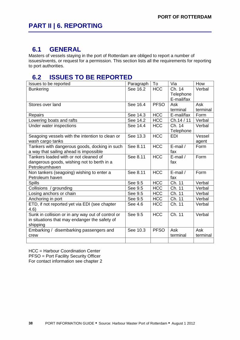
6.2 ISSUES TO BE REPORTED Issues to be reported Paragraph To Via How Bunkering See 16.2 HCC Ch. 14
Telephone E-mail/fax
Verbal
Stores over land See 16.4 PFSO Ask terminal
Ask terminal
Repairs See 14.3 HCC E-mail/fax Form Lowering boats and rafts See 14.2 HCC Ch.14 / 11 Verbal Under water inspections See 14.4 HCC Ch. 14
Telephone Verbal
Seagoing vessels with the intention to clean or wash cargo tanks
See 13.3 HCC EDI Vessel agent
Tankers with dangerous goods, docking in such a way that sailing ahead is impossible
See 8.11 HCC E-mail / fax
Form
Tankers loaded with or not cleaned of dangerous goods, wishing not to berth in a Petroleumhaven
See 8.11 HCC E-mail / fax
Form
Non tankers (seagoing) wishing to enter a Petroleum haven
See 8.11 HCC E-mail / fax
Form
Spills See 9.5 HCC Ch. 11 Verbal Collisions / grounding See 9.5 HCC Ch. 11 Verbal Losing anchors or chain See 9.5 HCC Ch. 11 Verbal Anchoring in port See 9.5 HCC Ch. 11 Verbal ETD, if not reported yet via EDI (see chapter 4.6)
See 4.6 HCC Ch. 11 Verbal
Sunk in collision or in any way out of control or in situations that may endanger the safety of shipping
See 9.5 HCC Ch. 11 Verbal
Embarking / disembarking passengers and crew
See 10.3 PFSO Ask terminal
Ask terminal
HCC = Harbour Coordination Center PFSO = Port Facility Security Officer For contact information see chapter 2
7 Port Description

PORT OF ROTTERDAM
PART III | 7. PORT DESCRIPTION
PORT INFORMATION GUIDE • Source: Harbour Master Port of Rotterdam • August 1 2012 40
7.1 GENERAL The port provides facilities for cargo handling, storage, and distribution. The port area also accommodates an extensive industrial complex. Most major carriers include Rotterdam in their services. From this strategically located port, the containers destined for other European countries are then forwarded by feeder services, inland vessels, railway or trucks. The size of the port’s industrial area and its position at the gateway of the European inland waterway network makes the port of Rotterdam ideally located for the transhipment of cargo. The port of Rotterdam is well equipped for handling bulk and general cargoes, coal and ores, crude oil, agricultural products, chemicals, containers, cars, fruit, and refrigerated cargoes. Facilities for ship repair, maintenance and storage are available. The port is never closed because of ice. Indeed, even in severe winters when drift ice is present in the river, the traffic of seagoing vessels continues uninterrupted. For more information on the port of Rotterdam, visit the website www.portofrotterdam.com/en/about_port/index.jsp
7.2 DEVELOPMENTS Rotterdam is working energetically on the realization of Maasvlakte 2. According to current plans, the first containers can be handled at Maasvlakte 2 in 2012. Entry to Maasvlakte 2 will go through the existing port area. Maasvlakte 2 will ultimately cover 1000 hectares for container handling, chemicals and distribution. The project will increase Rotterdam’s container transhipment capacity by 54%. For more information on Maasvlakte 2, visit the website www.maasvlakte2.com Next to this project the Port of Rotterdam is working on the development of one LNG terminal which will be situated near the entrance of the Beerkanaal. This terminal will be in operation in June 2011.
7.3 PORT LOCATION Rotterdam is situated at the entrance of the Nieuwe Waterweg river. Coordinates 52°00.0’N, 004°00.0’E.
7.4 PORT LIMITS The nautical supervision of the Port of Rotterdam Authority covers the following areas: the Eurogeul and Maasgeul channels, approach area and anchor areas the river Nieuwe Waterweg and Nieuwe Maas up to kilometer mark 991.5 the river Oude Maas up to kilometer mark 998 The following destinations are accessible for sea going vessels via the Maas Entrance:
• Rotterdam/Europoort • Vlaardingen • Schiedam • Dordrecht • Moerdijk • Zwijndrecht • Volkerak locks (connection to Antwerp)

PORT OF ROTTERDAM
PART III | 7. PORT DESCRIPTION
PORT INFORMATION GUIDE • Source: Harbour Master Port of Rotterdam • August 1 2012 41
7.5 LOAD LINES North Atlantic Winter Seasonal Zone II. Winter November 1 to March 31, Summer April 1 to October 31.
7.6 MAXIMUM SIZE VESSELS There are no restrictions regarding length and beam. Maximum draught is 22.55 meters. Not every berth can accommodate maximum size vessels, check the berth information first.
7.7 TIME ZONE GMT + 1 hr Night of last Saturday on Sunday in March and in October change to Daylight Saving Time (GMT+2 hrs).
7.8 LOCAL HOLIDAYS 2012 New Year’s Day January 1 Easter Sunday / Monday April 8,9 Ascension Day May 17 Whit Sunday and Whit Monday
May 27,28
Christmas Day, Boxing Day December 25,26
7.9 WORKING HOURS Official office hours: Monday – Friday, 09.00-17.00
7.10 TRAFFIC With 35.000 seagoing vessels and 130.000 inland vessels visiting us each year, the port of Rotterdam is characterized as having dense shipping traffic. Within the regional port area, cargo ship movements are over 400,000, while total ship movements amounts to 1 million each year. For more information on the port of Rotterdam, visit the website www.portofrotterdam.com/en/Port/port-statistics/Pages/default.aspx
7.11 CARGO Annually 430 million tons of goods are handled of which more than 110 million tons of IMO classified dangerous goods. For more information on the port of Rotterdam, visit the website www.portofrotterdam.com/en/Port/port-statistics/Pages/throughput.aspx

PORT OF ROTTERDAM
PART III | 7. PORT DESCRIPTION
PORT INFORMATION GUIDE • Source: Harbour Master Port of Rotterdam • August 1 2012 42
7.12 CHARTS AND BOOKS Int. 1416, NL/BA 1630, North Sea. West Hinder and Outer Gabbard to Vlissingen and Scheveningen Int. 1472, NL/BA 122, Approaches to Europoort and Hook of Holland Int. 1475, NL/BA 132, Nieuwe Waterweg, Nieuwe Maas, Oude Maas and Europoort Hoek van Holland to Rotterdam Int. 1476, NL/BA 133, Nieuwe Maas, Oude Maas, Noord and Dordtsche Kil, Rotterdam to Moerdijk Nautical Publication 28, Dover Strait Pilot Nautical Publication Admiralty List of Radio Signals, Volume 6 (1) HP1, Netherlands Coast Pilot HP8, Deep Draught Planning Guide Greenwich buoy to Europort HP33, Tidal heights-currents
7.13 SHIPPING ANNOUNCEMENTS FOR THE PORT AREA
Shipping Announcements concerning the port area can be obtained from the website www.portofrotterdam.com/en/Shipping/up-to-date/Bekendmakingen/
7.14 PILOT STATIONS See chapter 11.3
7.15 PORT INFRASTRUCTURE SEA BUOYS Sea buoy for ships with draught from 17.4 meters is the Euro buoy, position 51°57.6’N, 003°10.0’E, Iso 2s Sea buoy for ships with draught less than 17.4 meters is the Maas Center buoy, position 52°00.9’N, 003°48.8’E as of 11/05/09), Racon M (on 3 and 10 cm), Iso 4s ANCHOR AREAS Area Depth Location Use VHF Anchor area 1
28.5 meters MLLWS
52°07’N, 002°45’E
Long term anchorage (entering Eurogeul channel after 24 hours), for vessels with a draught from 17.40 up to 22.55 meters
Maas Approach (poor reception), VHF 01; telephone +31-10-252-2803
Anchor area 2
27.2 meters MLLWS
51°56’N, 002°57’E
Short term anchorage (entering Eurogeul channel within 24 hours), for vessels with a draught from 17.40 up to 22.55 meters
Maas Approach (poor reception), VHF 01; telephone +31-10-252-2803
Anchor area 3A
24.5 meters MLLWS
52°00’N, 003°20’E
Vessels that cannot anchor in number 4 or 5 anchor area because of their draught. Maximum draught is 17.4 meters
Maas Approach, VHF 01
Anchor area 3B
20.7 meters MLLWS
52°02’N, 003°36’E
For LNG carriers only Maas Approach, VHF 01
PORT OF ROTTERDAM
PART III | 7. PORT DESCRIPTION
PORT INFORMATION GUIDE • Source: Harbour Master Port of Rotterdam • August 1 2012 43
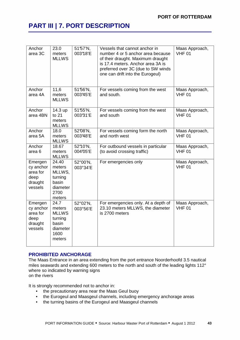
Anchor area 3C
23.0 meters MLLWS
51°57’N, 003°18’E
Vessels that cannot anchor in number 4 or 5 anchor area because of their draught. Maximum draught is 17.4 meters. Anchor area 3A is preferred over 3C (due to SW winds one can drift into the Eurogeul)
Maas Approach, VHF 01
Anchor area 4A
11,6 meters MLLWS
51°56’N, 003°45’E
For vessels coming from the west and south.
Maas Approach, VHF 01
Anchor area 4BN
14.3 up to 21 meters MLLWS
51°55’N, 003°31’E
For vessels coming from the west and south
Maas Approach, VHF 01
Anchor area 5A
18.0 meters MLLWS
52°08’N, 003°48’E
For vessels coming form the north and north west
Maas Approach, VHF 01
Anchor area 6
18.67 meters MLLWS
52°10’N, 004°05’E
For outbound vessels in particular (to avoid crossing traffic)
Maas Approach, VHF 01
Emergency anchor area for deep draught vessels
24.40 meters MLLWS, turning basin diameter 2700 meters
52°00’N, 003°34’E
For emergencies only Maas Approach, VHF 01
Emergency anchor area for deep draught vessels
24.7 meters MLLWS turning basin diameter 1600 meters
52°02’N, 003°56’E
For emergencies only. At a depth of 23.10 meters MLLWS, the diameter is 2700 meters
Maas Approach, VHF 01
PROHIBITED ANCHORAGE The Maas Entrance in an area extending from the port entrance Noorderhoofd 3.5 nautical miles seawards and extending 600 meters to the north and south of the leading lights 112° where so indicated by warning signs on the rivers It is strongly recommended not to anchor in:
• the precautionary area near the Maas Geul buoy • the Eurogeul and Maasgeul channels, including emergency anchorage areas • the turning basins of the Eurogeul and Maasgeul channels

PORT OF ROTTERDAM
PART III | 7. PORT DESCRIPTION
PORT INFORMATION GUIDE • Source: Harbour Master Port of Rotterdam • August 1 2012 44
If the wind increases to Beaufort 9 it is recommended to depart the anchorage ahead of time and keep the vessel going, specially during north westerly winds. RECOMMENDED UNDER KEEL CLEARANCE IN ANCHOR AREAS Worst swell conditions occur during north westerly gales (Beaufort 8), recommended under keel clearances in these conditions have been studies for some types of vessels: Anchor area 3A and 3C Tankers 305x46x17.4: 3,2 meters Anchor area 3B LNG Tankers 275x43x12,5: 2,8 meters LNG Tankers 315x50x13,0: 2,3 meters Anchor area 4A and 4B N Bulkers 190x23x10 meter: 4,0 meters Containervessels 180x25x10 meter: 5,9 meters Containervessels 350x43x14,5 meter: 3,6 meters Tankers 250x43x14,5 meter: 2,8 meters Anchor area 5 A and 6 Bulkers 190x23x10 meter: 4,7 meters Containervessels 180x25x10 meter: 5,9 meters Containervessels 350x43x14,5 meter: 4,4 meters Tankers 250x43x14,5 meter: 3,6 meters TENDER SERVICE ANCHOR AREAS See paragraph 16.4 PRECAUTIONARY AREA The precautionary area has an area to be avoided, marked by the Maas Geul bouy, position 52°00.9’N, 003°48.8’E as of 11/05/09. The pilot sta tion is located in the vicinity of the Maas Center bouy (52°01.1’N, 003°48.8’E). In the precautionary area dredging activities started for the construction of Maasvlakte 2, the extension of the port. Sand is tranported by suction dredgers from excavation sites to the Maasvlakte 2 area. The number of dredgers can vary between 4 and 7. The dredgers will operate north or south of the Sand bouy, position 51°59.8’N, 003°54.6’E, racon Z. VTS sector Pilot Maas will advise at which side the Sand bouy should be passed. PRINCIPAL MARKS Europlatform (52°00’N, 003°16.5’E). Light 4 x Mo (U) 15s. Red and white, helicopter platform, prominent weather observation platform and light tower. Goeree platform (51°55.5’N, 003°40.2’E). Light Fl(4) 20 s, Horn (4) 30s. Racon T. Red and white chequered tower, mounted on a platform (helicopter landing site) on piles.

PORT OF ROTTERDAM
PART III | 7. PORT DESCRIPTION
PORT INFORMATION GUIDE • Source: Harbour Master Port of Rotterdam • August 1 2012 45
CHANNELS EUROGEUL CHANNEL The Eurogeul channel is 25 nautical miles long, 600 meters wide, direction 082.5°, depth reducing from 24.5 to 24.0 meters MLLWS and is dedicated for ships with a draught of between 17.40 and 22.55 meters. The Eurogeul channel starts 1.4 miles west of the Euro 1 buoy. The bottom consists of sand, uneven in the west part, flatter in the east part. The Euro Channel is flanked on both sides by dredged areas 300 meters wide, which are less deep than the central channel at 22.00 meters MLLWS For safety’s sake, meeting in the Euro Channel should be avoided. When meeting manoeuvres are inevitable, the shoulders can be used. Sufficient under-keel clearance should be taken into account (15%). If the draft is more than 21,35 meters, the shoulders can not be used, the vessel must use the Eurogeul only. The Eurogeul channel is entered N of Euro light buoy (51°58’N, 003°10’E). The distance between buoys is 2.9 nautical miles Once in the Eurogeul channel, a vessel can turn halfway in the turning basin between buoys E7 and E9. The turning basin diameter is 2700 meters, depth 24.30 meters MLLWS. In emergencies this turning basin can also serve as an anchorage for vessels with a draught of up to 21.35 meters CROSSING THE EUROGEUL CHANNEL
• northbound between E5 and E7 light buoy (51°59.0’N, 003°28.0’E) • southbound between E3 and E5 light buoy (51°59.0’N, 003°23.0’E)
Crossing should be done without interfering with traffic MAAS GEUL BUOY The Maas Geul buoy (as of 11/05/09) is where the Euro Channel ends and the Maas Channel starts The Maas Geul buoy is surrounded by a precautionary area. This area can be extended to inside the breakwaters when pilotage is amended and Shore Based Pilotage is given. In this case, the pilot will board inside the breakwaters MAASGEUL CHANNEL The Maasgeul channel is 6 miles long. The width reduces from 600 meters at the Maas Center buoy to 500 meters at the harbour entrance. Direction 112.0°, depth 24,30 meters MLLWS The bottom consists of sand and is flat. There are no banks The center line of the channel is indicated by white leading lights, Iso 4s In the event of an emergency, and before entering the Maasgeul channel, a deep draught vessel can anchor in the emergency anchorage area situated to the northeast of the Maas Geul buoy, or use this area as a turning basin Ships of more than 14.30 meters draught can not meet or overtake each other in the Maasgeul CROSSING THE MAASGEUL CHANNEL, SMALL CRAFT PROCEDURE Through-going traffic should avoid the precautionary area and cross the traffic flow to and from the Maas Entrance perpendicularly vessels requiring to cross the Maasgeul channel are recommended to do so in an area between MN1 buoy and MV buoy. Before crossing, these vessels should report to the VTS sector Maas Entrance, VHF channel 03 and report name, position and course, and maintain a listening watch while crossing.
PORT OF ROTTERDAM
PART III | 7. PORT DESCRIPTION
PORT INFORMATION GUIDE • Source: Harbour Master Port of Rotterdam • August 1 2012 46
Crossing vessels should be fitted with a radar reflector. Sailing vessels are advised whenever possible to have their engines on standby or actually running to ensure a fast crossing, and if sailing together they should cross in a group due account must be taken that large vessels constrained by their draught to the deep water channel and showing the appropriate signals in accordance with the International Regulations for Preventing Collisions at Sea (1972) (daytime 1 black cylinder, nighttime 3 red lights) are unable to give way to other vessels BREAKWATERS Breakwaters are indicated by lights:
• breakwater at the north side: fixed red light, white tower, red bands, helicopter landing platform, during fog also Al Fl WR 6s (the Noorderdam itself gives a poor radar picture), depth is 22,85 meter MLLWS
• breakwater at the south side: fixed green light, with an additional horn, blowing every 10 seconds, white tower, green bands, helicopter landing platform, during fog also Al Fl WG 6s
FAIRWAYS Nieuwe Waterweg After leaving the Maasgeul channel, the Splitsingsdam separates
the Nieuwe Waterweg from the Caland kanaal. The Splitsingsdam is a separation mole. The center line of the entrance to the river Nieuwe Maas is 107.0° and indicated by red leading lights, Iso 6s. Minimum depth 14.20 meters MLLWS. Near Maassluis a ferry crosses the river
Nieuwe Maas The Nieuwe Waterweg river becomes the Nieuwe Maas river. Minimum depth 13.80 meters MLLWS to Waalhaven, from Waalhaven to Erasmusbrug 10.85 meters MLLWS, after Erasmusbrug 6.85 meters MLLWS
Calandkanaal The direction of the entrance to the Caland Canal and Beer Canal is 116.0°, the central line is indicated by green leading lights, occulting 6s. Minimum depth 22.75 meters MLLWS
Beerkanaal Entry to the Europoort area is via the Beer Canal The direction of 192.5° is indicated by green leading lights, occulting 3s. Minimum depth 22.6 meters MLLWS
Oude Maas When passing the Oude Maas, two bridges must be passed: Botlek bridge and Spijkenisse bridge Permission is required to navigate this river with seagoing vessels with a length of 175 meters or more, or a beam of over 25 meters, or if the draught is more than 8.80 meters (in fresh water) for destination Dordrecht or 8.00 meters for destination Moerdijk Permission must be requested via Vessel Traffic & Operations 24 hours prior to arrival, see communication procedure Minimum depth Oude Maas 9.60 meters MLLWS to Spui. After Spui 9.40 meter MLLWS One power line crosses the river, situated at +45.00 meters NAP
STORM SURGE BARRIER An storm surge barrier barrier has been constructed across the Nieuwe Waterweg approximately 2 miles upstream from the conspicuous leading light (Iso R 6 sec) at Berghaven (51°75.3’N, 004°09.6’E). The width between the two doors is 360 meters

PORT OF ROTTERDAM
PART III | 7. PORT DESCRIPTION
PORT INFORMATION GUIDE • Source: Harbour Master Port of Rotterdam • August 1 2012 47
The storm surge barrier will close when a water height is predicted of at least 3.00 meters + NAP in Rotterdam Free passage is possible up to 2 hours before closure. Ships will be notified as quickly as possible through different channels or agencies Another storm surge barrier has been constructed across the Hartel Canal, which will close simultaneously with the one located on the Nieuwe Waterweg. This barrier is being closed for testing purposes once a year Trial closures will be announced well in advance through Shipping Announcements and agencies. Shipping Announcements concerning the port area can be obtained from the website www.portofrotterdam.com/en/Shipping/up-to-date/Bekendmakingen/
7.16 PORT ACCOMMODATION AND BERTHS DEPTH AT BERTHS Depth at berths is indicated in the “Vademecum” of the Port of Rotterdam. The “Vademecum” is a serie of maps displaying all the berths in the port of Rotterdam. The depth displayed either is the “contractual depth”, being the depth that is agreed upon as per contract with the terminal, or the nautical depth, at which fairways and turning basins are maintained by the Port Authority. Depth figures in the Vademecum are displayed in NAP (Nieuw Amsterdams Peil, this datum is comparable to mean sea level) or in LAT (Lowest Astronomical Tide). Generally speaking, a vessel should not exceed a draught, in accordance with this contractual or nautical depth. A vessel with a draught, exceeding this specified draught, is only allowed to sail after permission from the Harbour Master. The Master can obtain information on actual depth via Vessel Traffic & Operations (see chapter 2.2) HOW TO FIND A BERTH If you are on your way to a certain destination in Rotterdam’s port and industrial area, the port number or shore site number can help you. Port numbers (displayed as “havens”) are for road traffic, while shore site numbers are for shipping. This signposting works as follows: SHORE SITE NUMBERS – WATER SIDE In the port of Rotterdam, the whole shore along the river, canal or port basin is numbered. There is a shore site number every 100 meters. These are shown in black figures on a yellow background and can be found on quays, slopes, inclines and jetties. The system is the same as with the port numbers (from east to west, on the right (north) bank from 100 to 999 and on the left (south) bank from 1000 to 9900). Every port basin has a separate series of numbers. This is one reason why the numbering is not always continuous. Depending on the length of the shore, a company will have one or more shore site numbers corresponding with the port number. PORT NUMBERS – SHORE SIDE Every company or location in the port of Rotterdam has a port number. The numbers run from east to west. On the right (north) bank, the numbers run from 100 to 999, and on the left (south) bank from 1000 to 9900. The port numbers are incorporated into the port signposting, which can be found along all roads in and around the port of Rotterdam. The road signs

PORT OF ROTTERDAM
PART III | 7. PORT DESCRIPTION
PORT INFORMATION GUIDE • Source: Harbour Master Port of Rotterdam • August 1 2012 48
show a number or a series of numbers under the word “Havens” (ports), consisting of black figures on a white background. If you know the port number of the company or location you are seeking, you can find the desired area simply by following the directions on these signs. At the entrance, depot or fence of your destination, the port number will be given in black numbers on a white sign with a blue border. If you do not know the port number of the location you are seeking, you can look it up at one of the information points at petrol stations or parking areas in the vicinity of Rotterdam. These are indicated along motorways by “I Rotterdamse haven”. The information points are shown on the map on the back. If you are carrying hazardous cargo, you must follow the route for hazardous substances. This means that sometimes you have to deviate from the numbers indicated by the signs. However, you will continue to find yourself on the route given by the port signposting.
7.17 WEATHER AND TIDAL INFORMATION For general information regarding traffic, weather, tides, current, sea conditions, fog, ice, etc. the appropriate Traffic Center sector can be contacted via VHF channel 11. Online hydrometeo information can be found at the website www.portofrotterdam.com/en/Shipping/up-to-date/Hydrometeo/ When gale force winds are expected (Beaufort 8), weather forecasts are being transmitted at 00.50, 01.50, 02.50, etc. on VHF ch. 19 by the Harbour Coordination Center. WIND All measured at Hook of Holland: Prevailing winds: W – SW, force 4 or 5 Relative frequency of wind forces greater than force 7 Beaufort: 2% TIDE GENERAL In a period of 24 hours there are 2 high waters and 2 low waters, with different amplitudes (i.e. one high water is higher than the other, one low water is lower than the other). A special phenomenon manifests itself at Hook of Holland, which has a double low tide with the second low water lower than the first. AT SEA Strong and sustained winds from the north-west raise water levels along the Dutch coast Strong and sustained winds from the south-east have the opposite effect ON THE RIVER The timing and actual tidal levels in the waterway depend greatly on the wind and state of the river. When the river outflow is low (in the summer and winter), HW and LW levels are about 0.1 to 0.2 meters lower than predicted When the river outflow is high (in the spring and autumn), HW and LW levels may be more than 0.1 meter higher than predicted
PORT OF ROTTERDAM
PART III | 7. PORT DESCRIPTION
PORT INFORMATION GUIDE • Source: Harbour Master Port of Rotterdam • August 1 2012 49
During spring tides with strong W to NW winds, the river level may increase by 1 meter or more. Mean tidal range is 1.70 meters, and spring tidal range is 1.80 meters. TIDAL CURRENT AT SEA, MAAS ENTRANCE, IN FRONT OF BREAKWATER Vessels passing the port entrance should beware of the cross current running at the entrance. This current attains its maximum rate at half hour before HW Hook of Holland After the tide turns, the flood current sets in quickly, whereas the ebb current sets in more gradually. Due to the construction of Maasvlakte 2 current patterns at the entrance to Hoek van Holland have changed. Changes are most noticeable during flood tide. The flood current follows the new coastal line in a northerly direction and, near buoy MVN, diverts in an easterly direction. As a consequence, the cross current, east of MVN, is less than in the old situation. Also rate of decrease is more gradual. The turn of the flood tide near the harbour entrance starts lightly earlier than in the old situation. A remarkable new phenomenon is a counter current, which occurs after high water, between buoy MV-N and the port entrance. The east going flood current partly bears off in a southern direction and continues in a westerly direction, directly under the new coastline of Maasvlakte 2. In the vicinity of MVN, the counter current merges again with the north-going flood current. The strength of the counter current varies with tidal range, wind and river discharge. The effects of the counter current are rather weak, but may be experienced up to the Maasgeul. The counter current is most dominant during spring tide. During ebb tide, no changes of any significance have been reported, apart from the fact that the ebb current, at the port entrance, bears off in a westerly direction to follow the new coastal line of Maasvlakte 2. Mean current rates are 2.5 knots during flood and 2.0 knots during ebb. Weather conditions and river discharge can influence the average current rate. The wind influences only the rate of the currents, and not their direction. Strong SW winds cause a strong NE current, and a weak SW current Strong NW winds cause a strong SW current, and a weak NE current Current rates up to 4 knots may occur in stormy periods Off the Maas Entrance (52°00’N, 004°02’E), during the ebb current, the meeting of the discolored river water and the cleaner North Sea water is plainly visible. This meeting is usually indicated by a line of ripples extending WNW, NW or N from the Noorderdam mole head, but never S of a line running seaward of the Noorderdam axis The distance to which the line of ripples extends, and its direction, depends on the relative rate and direction of the ebb and outer currents, and the force and direction of the wind. For example, with a strong E wind and ebb current, it may extend 7 or 8 miles seaward in the direction of Noorderdam, whereas at other times it may only extend for a very short distance ON THE RIVER When the discharge of the river Rhine is high because of melt water from the Swiss mountains (in the spring) or during heavy rainfall, the river is running at full spate. In that situation, the outgoing current at Hook of Holland and Maassluis (51°55’N, 004°15’E) can exceed 3 knots. If, in addition, the prevailing winds are from the E and S, then there may be little or no ingoing current at Hook of Holland Further up river the rate and duration of the ingoing stream are reduced.

PORT OF ROTTERDAM
PART III | 7. PORT DESCRIPTION
PORT INFORMATION GUIDE • Source: Harbour Master Port of Rotterdam • August 1 2012 50
During spring tides and with strong W to NW winds, the duration of the ingoing current is increased. The current is stronger near the axis of the river than at the side of the river. CROSS SECTION OF NIEUWE WATERWEG AND OUDE MAAS Attention should be paid to the area where the river Oude Maas runs into the Nieuwe Waterweg/Nieuwe Maas junction (51°53.5’N, 004°19.5’E). From half an hour before to 4 hours after high water at Hook of Holland there is a strong set to the south. At other times there is a strong set to the north. Failure to pay sufficient attention to this effect could cause you to end up on the wrong side of the river. OVERVIEW OF CURRENTS IN RELATION TO HIGH WATER HOOK OF HOLLAND (HW HOH) Location Time
max. flood
Rate max. flood
Direction max. flood
Time slack water
Time max. ebb
Rate max. ebb
Direction max. ebb
Maas Entrance, in front of breakwater
-0.5 hrs HW HoH
2.5 knots ENE -2.25 and +3.75 hrs HW HoH
-6.0 hrs HW HoH
1.6 knots SW
Maas Entrance, inside breakwater
-0.5 hrs HW HoH
2.5 knots E -2.25 and + 3.75 hrs HW HoH
-6.0 hrs HW HoH
1.6 knots W
Nieuwe Waterweg, at Botlek
+0.5 hrs HW HoH
2.5 knots E -1.2 and +3.00 hrs HW HoH
+5.5 hrs HW HoH
2.5 knots W
Nieuwe Maas, at Waalhaven
+ 0.5 hrs HW HoH
1.4 knots E -1.0 and + 3.0 hrs HW HoH
+5.5 hrs HW HoH
1.6 knots W
Oude Maas, near berth 4010
+ 1.5 hrs HW HoH
1.6 knots S -0.5 and + 4.0 hrs HW HoH
+ 6.0 hrs HW HoH
2.2 knots N
SEA CONDITIONS The wind and tide strongly influence the sea conditions in the approaches to the Maas Entrance. Storm conditions may make entering the harbour hazardous. The main effects are: storm force winds from the NW cause a rough sea with a possible ground swell at the time of LW. Wave heights may exceed 6 meters. The best time to enter is from about 2 hours before to 2 hours after HW, especially about HW. Reducing speed to let the waves run faster than the vessel is recommended in these circumstances storm force winds from the SW cause less severe seas. The best time to enter is 1 to 2 hours after HW, when the strength of the ingoing current will have decreased and the ship will be less likely to swing to starboard when entering. A ground swell can occasionally arise while

PORT OF ROTTERDAM
PART III | 7. PORT DESCRIPTION
PORT INFORMATION GUIDE • Source: Harbour Master Port of Rotterdam • August 1 2012 51
the ebb current is running. A confused sea can occur when an out flowing current meets a strong westerly wind FOG All measured at Hook of Holland. The frequency of visibility at Hook of Holland less than 1,500 meters is 1,4% The frequency of visibility at Hook of Holland less than 500 meters is 0,6% ICE The navigation from sea to Rotterdam is open at all times. WATER DENSITY (Depending on seasonal, tidal and meteorological influences.) Europoort: generally ranges from 1025 kg/m3 at high water to 1012 kg/m3 at low water, depending on seasonal, tidal and meteorological influences Botlek: between 1,000 and 1020 kg/m3 Waalhaven: around 1,000 kg/m3. More detailed information may be obtained via Harbour Master’s Office, see chapter 2. SEICHES Seiches appear in the Europoort area with extremes near the Rozenburg locks. Under extreme conditions a tidal difference of 0,20 meters can occur. Although seiches are hard to predict, they will be taken into consideration in the daily predictions whenever possible. For online updates visit www.portofrotterdam.com/en/Shipping/up-to-date/Hydrometeo/
7.18 WEBCAMS A map with the locations with webcams and their links can be found on www.portofrotterdam.com/en/Port/port-in-picture/Pages/WebcamsMap.aspx

8 Port Navigation

PORT OF ROTTERDAM
PART III | 8. PORT NAVIGATION
PORT INFORMATION GUIDE • Source: Harbour Master Port of Rotterdam • August 1 2012 54
8.1 GENERAL Draught figures are related to a draught in density 1.025 T/m3 unless stated otherwise.
8.2 SPEED Container vessels with destination Waalhaven, sailing on Nieuwe Maas between kilometre mark 1014 and 1004 have a maximum speed of 5 to 6 knots (due to squat effect). There are no other speed restrictions in force. However, it is forbidden to cause hinder/damage by your wake.
8.3 UKC Ships with a draught of between 00.00 and 17.39 meters
Rivers: 10% of the ship’s draught UKC Beer Canal and Caland Canal 1.00 meter UKC Port basins: 0.50 meter UKC Berth: always afloat, recommended 0,30 meter. For certain container ships destined for Waalhaven/Eemhaven an UKC of 1.00 meter is sufficient if various conditions are met. For details check with your agent
Ships with a draught of between 17.40 and 21.99 meters
Arrival The Plan of Entry for the Eurogeul and Maasgeul will be calculated in accordance with a probabilistic method. In the most unfavourable circumstances (including squat, movement of the ship and other uncertainties), the ship has a minimum UKC of 1.00 meter everywhere. Under normal circumstances, the ship will have considerably more. Departure Because the ship is sailing against the incoming tide, the maximum draught on departure is 20.75 meters. Only in special conditions and after contacting Vessel Traffic & Operations draught on departure can be increased up to 21.20 meters. In port basins and Caland and Beer Canals, the ship must have a UKC of 1.00 meter. The plan of departure for the Eurogeul and Maasgeul will have been calculated using a deterministic method, and will guarantee a minimum UKC of 10% of the vessel’s draught in the Maasmond, and 15% in the Maasgeul and Eurogeul. Berth Berth: always afloat Recommended 0.50 meter UKC
PORT OF ROTTERDAM
PART III | 8. PORT NAVIGATION
PORT INFORMATION GUIDE • Source: Harbour Master Port of Rotterdam • August 1 2012 55
Ships with a draught of between 22.01 and 22.55 meters
Arrival The Plan of Entry will be calculated in accordance with a probabilistic method. In the most unfavourable circumstances (including squat, movement of the ship and other uncertainties), the ship has a minimum UKC of 1.50 meter everywhere. Under normal circumstances, the ship will have considerably more. Departure Because the ship is sailing against the incoming tide, the maximum draught on departure is 21.50 meters (density 1025) for the terminals of MOT, EMO, EECV, BP, Team 3 and Dolphins 80. For Vopak 7e Petroleumhaven and Team 2 it is 21.10 meters. All under average neap tide conditions. In port basins and Caland and Beer Canals, the ship must have a UKC of 1.00 meter. The plan of departure will have been calculated using a deterministic method, and will guarantee a minimum UKC of 10% of the vessel’s draught in the Maas Entrance, and 15% in the Maas Channel and Euro Channel. Berth Berth: always afloat Recommended 0.50 meter UKC
8.4 RIGHT OF WAY Draught restricted ships have right of way in accordance with rule 10.08 of the Inland Navigation Police Regulations (BPR). Dredgers operate in all waterways. They show signals in accordance with the International Regulations for Preventing Collisions at Sea, Rule 27. Dredgers will keep clear of vessels showing the International Signal for vessels constrained by their draught. Other vessels should give the dredger a wide berth when passing and should make this intention clear in order not to interrupt the dredging operations.
8.5 SPACING OF VESSELS No regulations, use good seamanship.
8.6 PASSING ARRANGEMENTS See VTS section, chapter 11.2 For passing arrangements in Euro and Maasgeul see chapter 7.15.
8.7 RESTRICTIONS Whenever visibility decreases to less than 700 meters on any part of the intended sailing route, pilotage may be compulsory for Pilotage Exemption Certificate holders When in a part of the Rotterdam area visibility decreases to less than 500 meters, the Department of Vessel Traffic & Operations will enforce the following rules:
PORT OF ROTTERDAM
PART III | 8. PORT NAVIGATION
PORT INFORMATION GUIDE • Source: Harbour Master Port of Rotterdam • August 1 2012 56
• visibility between 200 and 500 meters: if the ship requires tugs, the Department of Vessel Traffic & Operations will consult the pilot association and tugboat companies as to whether the ship can sail
• visibility less than 200 meters: the Department of Vessel Traffic & Operations will always contact the pilot as to whether the ship can sail
• if the vessel has a draught between 17.40 and 22.55 she is not allowed to enter port if visibility is less than 500 meters in the Europoort area
Traffic guidance is supplied by VTS when visibility is less than 1,000 meters on the river or less than 2,000 meters in the approach area and Europoort. SIZE AND TYPE RESTRICTIONS Harbour basins located at
The Nieuwe Waterweg/ Nieuwe Maas rivers/ Destination Oude Maas, Moerdijk, Dordrecht
Ships might have a tidal window depending on UKC, current, and type of ship Detailed information can be obtained from Harbour Master’s Office (chapter 2) or via the vessel’s agent
Oude Maas, Moerdijk, Dordrecht
If ship’s length is more than 175 meters, or its width is more than 25 meters, permission must be obtained from Harbour Master’s Office (see chapter 2) The maximum overhead clearance (Oude Maas) is 43 meters (MHWS)
Berths for tankers Tankers loaded with or not cleaned of dangerous goods may berth in the Petroleumhavens only (see chapter 11.3) Harbour Master’s Office can permit deviation from this rule (See chapter 2) for non-tankers.
8.8 INWARD BOUND VESSELS APPROACHES TO HOOK OF HOLLAND, COMING FROM THE WEST AND SOUTH Draughts of up to 14.29 meters
These ships do not receive a “Plan of Entry”, and can enter at any time (except in the case of tidal windows) Vessels should not use the Eurogeul channel, as this is a deep water route, primarily intended for ships with draughts of between 1740 and 22.55 meters Pilot station: see paragraph 11.3 No compulsory use of Maasgeul channel Follow Traffic Separation Scheme south of the Eurogeul Keep the pilot cutter on the lee side unless advised otherwise When entering the port entrance with maximum current, the ship must be able to maintain a speed of 8 to 10 knots in order to be able to compensate for the cross current LNG carriers: Via TSS Maas West. Between buoy E5 and E7 enter the

PORT OF ROTTERDAM
PART III | 8. PORT NAVIGATION
PORT INFORMATION GUIDE • Source: Harbour Master Port of Rotterdam • August 1 2012 57
Eurogeul. Tankers: see “Ships Routeing” part G for mandatory route
Draught between 14.30 and 17.39 meters
These ships do not receive a “Plan of Entry” Entry time depends on traffic (except in the case of tidal windows) Eurogeul channel is primarily intended for ships with draughts of between 17.40 and 22.55 meters If the Eurogeul is used, enter the Eurogeul channel between buoys E7 and E9, or at the start of the Eurogeul channel, at the Euro Buoy. If the Eurogeul is not used, see section for ships up to 14.29 meters Ships using the Eurogeul should stay well clear of vessels constrained by their draught. Contact Maas Approach on VHF Ch. 1 before entering the Eurogeul Pilot station: see paragraph 11.3 The use of the Maasgeul channel is not compulsory, but strongly recommended Ships can pass the Maas Center buoy and pilot cutter via the north side When entering the port entrance with maximum current, the ship must be able to maintain a speed of 8 to 10 knots in order to be able to compensate for the cross current Tankers: see “Ships Routeing” part G for mandatory route
Draught of between 17.40 and 19.99 meters
These ships receive a “Plan of Entry” at least 6 hours before arrival. This is a message that indicates the time at which the ship should be at the rendezvous point (51°59.0’N, 003°00.0’E) and the time at which she is expected to pass the Maas Entrance (in detail lower leading light of the Maasgeul channel (51°58.9’N, 004°04.9’E)) Entry time depends on traffic (except in the case of tidal windows and in case of extreme wind conditions also on wave conditions) If more than one vessel with a draught of more than 17.40 meters is scheduled to navigate in the Eurogeul and Maasgeul channel, an interval of at least 45 minutes is prescribed between these vessels The pilots will confirm the Plan of Entry by a sailing plan. After confirmation by the harbour master, permission will be granted by Traffic Control Once the pilots are on board, should the ship expect that the passing time of the lower leading light (112°) will deviate by more than 15 minutes, the appropriate sector must be notified accordingly Pilot station: see paragraph 11.3 The Eurogeul channel is entered via the Eurogeul channel Approach Area near the Euro buoy (51°57.7’N, 003°10.0’E) The planned speed for the Eurogeul channel is about 10 knots, and for the Maasgeul channel about 8 knots Tankers: see “IMO Ships Routeing” part G for mandatory route
Draught of between 20.00 and 21.95 meters
These ships receive a “Plan of Entry” at least 6 hours before arrival. This is a message that indicates the time at which the ship should be at the rendezvous point (51°59.0’N, 003°00.0’E) and the time at which she is expected to pass the Maas Entrance (in detail lower leading light of the Maasgeul channel (51°58.9’N, 004°04.9’E)) Entry time depends on traffic and vertical tide, time of arrival will be around High Water Hook of Holland

PORT OF ROTTERDAM
PART III | 8. PORT NAVIGATION
PORT INFORMATION GUIDE • Source: Harbour Master Port of Rotterdam • August 1 2012 58
If more than one vessel with a draught of more than 17.40 meters is scheduled to navigate in the Eurogeul and Maasgeul channel, an interval of at least 45 minutes is prescribed between these vessels The pilots will confirm the Plan of Entry by a sailing plan. After confirmation by the harbour master, permission will be granted by Traffic Control Once the pilots are on board, should the ship expect that the passing time of the lower leading light (112°) will deviate by mor e than 15 minutes, the appropriate sector must be notified accordingly Pilot station: see paragraph 11.3 The Eurogeul channel is entered via the Eurogeul channel Approach Area near the Euro buoy (51°57.7’N, 003°10.0’E) The minimum speed to enable passing the channels is 7 knots over the ground The maximum speed will be given, with a maximum of 11 knots over the ground to prevent squat in the Eurogeul Tankers: see “IMO Ships Routeing” part G for mandatory route
Draught between 21.96 and 22.55 meter
These ships receive a “Plan of Entry” at least 6 hours before arrival. This is a message that indicates the time at which the ship should be at the rendezvous point (51°59.0’N, 003°00.0’E) and the time at which she is expected to pass the Maas Entrance (in detail lower leading light of the Maasgeul channel (51°58.9’N, 004°04.9’E)) The entry time depends on traffic, vertical tide and horizontal tide, and the time of arrival will be around High Water Hook of Holland. It is advised to avoid a cross current at the Maas Entrance of more than 1.7 knots, because a maximum drift angle of 18° and a maximum speed over ground of 7 knots or a maximum speed through the water of 5.5 knots are the acceptable limits If more than one vessel with a draught of more than 17.40 meters is scheduled to navigate in the Eurogeul and Maasgeul channel, an interval of at least 45 minutes is prescribed between these vessels The pilots will confirm the Plan of Entry by a sailing plan. After confirmation by the harbour master permission will be granted by Traffic Control Once the pilots are on board, should the ship expect that the passing time of the lower leading light (112°) will deviate by more than 15 minutes, the appropriate sector must be notified accordingly Pilot station: see paragraph 11.3 The Eurogeul channel is entered via the Euro Channel Approach Area near the Euro buoy (51°57.7’N, 003°10.0’E) The minimum speed to enable passing the channels is 7 knots over the ground The maximum speed will be given, with a maximum speed of 11 knots over the ground to prevent squat in the Eurogeul channel Tankers: see “IMO Ships Routeing” part G for mandatory route
PORT OF ROTTERDAM
PART III | 8. PORT NAVIGATION
PORT INFORMATION GUIDE • Source: Harbour Master Port of Rotterdam • August 1 2012 59
APPROACHES TO HOOK OF HOLLAND, COMING FROM A NORTHE RLY DIRECTION AND FROM A NORTHWESTERLY DIRECTION Draughts of up to 14.29 meters
These ships do not receive a “Plan of Entry”, and can enter at any time (except in the case of tidal windows) Vessels should not use the Eurogeul channel, as this is a deep water route, primarily intended for ships with draughts of between 17.40 and 22.55 meters During the approach to the pilot station pass the Maas Center bouy via the west side Pilot station: see paragraph 11.3 No compulsory use of Maasgeul channel Follow Traffic Separation Scheme West of the Maas North TSS. For ships coming from the north west: follow TSS West of the Maas North-West TSS. Keep the pilot cutter on the lee side unless advised otherwise When entering the port entrance with maximum current, the ship must be able to maintain a speed of 8 to 10 knots in order to be able to compensate for the cross current Tankers: see “Ships Routeing” part G for mandatory route. As long as one passes the “Bruine Bank” via the south side coming from the Deep Water route one can use the Traffic Separation Scheme Maas North West
Draught of between 14.30 and 17.39 meters
These ships do not receive a “Plan of Entry” Entry time depends on traffic (except in the case of tidal windows) Eurogeul channel is primarily intended for ships with draughts of between 17.40 and 22.55 meters If the Eurogeul is used, enter the Eurogeul channel between buoys E7 and E9, or at the start of the Eurogeul channel, at the Euro Buoy. If the Eurogeul is not used, see section for ships up to 14.29 meters Ships using the Eurogeul should stay well clear of vessels constrained by their draught. Contact Maas Approach on VHF Ch. 1 before entering the Eurogeul Pilot station: see paragraph 11.3 The use of the Maasgeul channel is not compulsory, but strongly recommended Ships can pass the Maas Center buoy and pilot cutter via the north side When entering the port entrance with maximum current, the ship must be able to maintain a speed of 8 to 10 knots in order to be able to compensate for the cross current Tankers: see “Ships Routeing” part G for mandatory route. As long as one passes the “Bruine Bank” via the south side coming from the Deep Water route one can use the Traffic Separation Scheme Maas North West

PORT OF ROTTERDAM
PART III | 8. PORT NAVIGATION
PORT INFORMATION GUIDE • Source: Harbour Master Port of Rotterdam • August 1 2012 60
8.9 OUTWARD BOUND VESSELS DEPARTURE FROM HOOK OF HOLLAND, SOUTH/WEST BOUND Draughts of up to 14.29 meters
These ships do not receive a “Plan of Departure”, and can depart at any time (except in the case of tidal windows) No compulsory use of Maasgeul channel Vessels should not use the Eurogeul channel, as this is a deep water route, primarily intended for ships with draughts of between 17.40 and 22.55 meters Pilot station: see paragraph 11.3 Pass the Maas Geul buoy via the north side Follow Traffic Separation Scheme north of the Eurogeul channel LNG carriers: via TSS Maas West. At buoy MNW3-MW6 the pilot will disembark. Tankers: see “IMO Ships Routeing” part G for mandatory route
Draught of between 14.30 and 17.39 meters
These ships do not receive a “Plan of Departure” Departure time depends on traffic (except in the case of tidal windows) Eurogeul channel is primarily intended for ships with draughts of between 17.40 and 22.55 meters If the Eurogeul is used, leave the Eurogeul channel between buoys E7 and E9, or at the start of the Eurogeul channel, at the Euro Buoy. If the Eurogeul is not used, see section for ships up to 14.29 meters Ships using the Eurogeul should stay well clear of vessels constrained by their draught, as the Eurogeul channel, as this is a deep water route, is primarily intended for ships with draughts of between 17.40 and 22.55 meters. Contact Maas Approach on VHF Ch. 1 before entering the Eurogeul Pilot station: see paragraph 11.3 The use of the Maasgeul channel is not compulsory, but strongly recommended Tankers: see “Ships Routeing” part G for mandatory route
Draught of between 17.40 and 20.75 meters
Maximum draught on departure is 20.75 meters. In highly favourable conditions, a maximum of 21.20 meters is possible These ships receive a “Plan of Departure”, at least 6 hours before departure. This is a message that indicates the time at which the ship is expected to pass the Maas Entrance (in detail lower leading light of the Maas Channel (51°58.9’N, 004°04.9’E)) The departure time depends on traffic and tide If more than one vessel with a draught of more than 17.40 meters is scheduled to navigate in the Eurogeul and Maasgeul channel, an interval of at least 45 minutes is prescribed between these vessels The pilots will confirm the Plan of Departure by a sailing plan. After confirmation by the harbour master, permission will be granted by Traffic Control Once the pilots are on board, should the ship expect that the passing time of the lower leading light will deviate by more than 15 minutes, the appropriate sector must be notified accordingly Pilot station: see paragraph 11.3 Tankers: see “IMO Ships Routeing” part G for mandatory route

PORT OF ROTTERDAM
PART III | 8. PORT NAVIGATION
PORT INFORMATION GUIDE • Source: Harbour Master Port of Rotterdam • August 1 2012 61
DEPARTURE FROM HOOK OF HOLLAND, NORTHBOUND OR NORTH WEST BOUND Draughts of up to 14.29 meters
These ships do not receive a “Plan of Departure”, and can leave at any time (except in the case of tidal windows) No compulsory use of Maasgeul channel Vessels should not use the Eurogeul channel, as this is a deep water route, primarily intended for ships with draughts of between 17.40 and 22.55 meters Pass the Maas Geul buoy via the north side Use the Traffic Separation Scheme Maas North or TSS Maas North-West. Pilot station: see paragraph 11.3 Tankers: see “IMO Ships Routeing” part G for mandatory route. In this respect is Amsterdam an “adjacent port area”. As long as one passes the “Bruine Bank” via the south side, and enter the Deep Water route, one can use the Traffic Separation Scheme Maas North West
Draught of between 14.30 and 17.40 meters
These ships do not receive a “Plan of Departure” Departure time depends on traffic (except in the case of tidal windows) Eurogeul channel is primarily intended for ships with draughts of between 17.40 and 22.55 meters If the Eurogeul is used, leave the Eurogeul channel between buoys E7 and E9, or at the start of the Eurogeul channel, at the Euro Buoy. If the Eurogeul is not used, see section for ships up to 14.29 meters Ships using the Eurogeul should stay well clear of vessels constrained by their draught, as the Eurogeul channel, as this is a deep water route, is primarily intended for ships with draughts of between 17.40 and 22.55 meters. Contact Maas Approach on VHF Ch. 1 before entering the Eurogeul Pilot station: see paragraph 11.3 The use of the Maasgeul channel is not compulsory, but strongly recommended Tankers: see “Ships Routeing” part G for mandatory route. In this respect is Amsterdam an “adjacent port area”. As long as one passes the “Bruine Bank” via the south side, and enter the Deep Water route, one can use the Traffic Separation Scheme Maas North West
8.10 SHIFTING VESSELS Also shifting vessels may have tidal windows, see “size and type restrictions”.
8.11 DOCKING TANKERS WITH DANGEROUS GOODS Tankers with dangerous goods must dock in such a way that they can depart from a port basin by sailing ahead, unless this is impossible because of their draught or other nautical circumstances. If sailing ahead is impossible, the fact should be reported - preferably well in advance - to HCC See Harbour Master’s Office, chapter 2.

PORT OF ROTTERDAM
PART III | 8. PORT NAVIGATION
PORT INFORMATION GUIDE • Source: Harbour Master Port of Rotterdam • August 1 2012 62
TANKERS LOADED WITH OR NOT CLEANED OF DANGEROUS GOO DS Tankers loaded with or not cleaned of dangerous good may berth in the “Petroleumhavens” only. The Harbour Master’s Reporting Center can permit deviation from this rule. See Harbour Master’s Office, chapter 2. See list of Petroleumhavens chapter 10.3. NON TANKER VESSELS Non tanker vessels may request a licence to enter the Petroleumhavens from the Harbour Coordination Center. See Harbour Master’s Office, chapter 2. See list of Petroleumhavens chapter 11.3. For mooring guidelines see 11.5.
8.12 DISPLAY OF SIGNALS AND LIGHTS The following vessels are considered to be restricted in manoeuvrability and must show the signal required by rule 28 of the International Regulations for Preventing Collisions at Sea 1972 (black cylinder daytime, three red lights vertically nighttime): Vessels in Maasmond, Beerkanaal and Calandkanaal and adjoining port basins and with a draught of 14,30 meters or more or with a length of 300 meters or more. Vessels in Nieuwe Waterweg, Nieuwe Maas and adjoining port basins and with a draught of 9 meters or more or with a length of 200 meters or more. Vessels with a draught of 7 meters or more or with a length of 135 meters or more, whilst in the Oude Maas, must show the same signals.

9 Port Safety
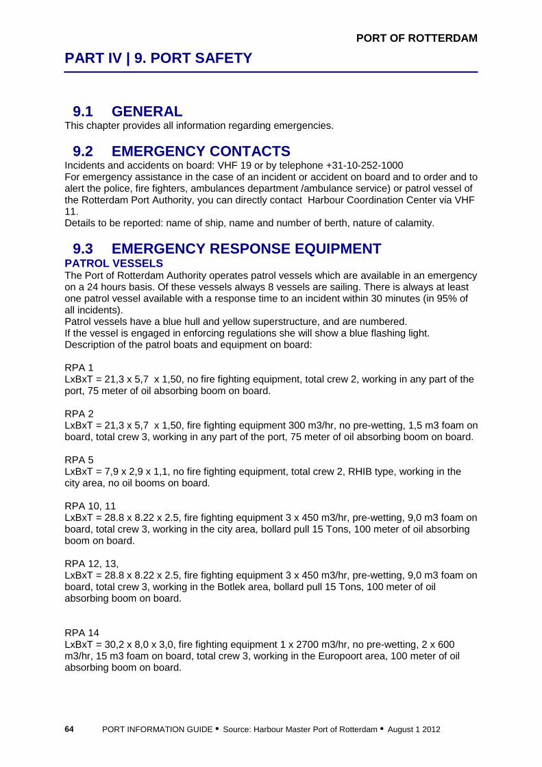
PORT OF ROTTERDAM
PART IV | 9. PORT SAFETY
PORT INFORMATION GUIDE • Source: Harbour Master Port of Rotterdam • August 1 2012 64
9.1 GENERAL This chapter provides all information regarding emergencies.
9.2 EMERGENCY CONTACTS Incidents and accidents on board: VHF 19 or by telephone +31-10-252-1000 For emergency assistance in the case of an incident or accident on board and to order and to alert the police, fire fighters, ambulances department /ambulance service) or patrol vessel of the Rotterdam Port Authority, you can directly contact Harbour Coordination Center via VHF 11. Details to be reported: name of ship, name and number of berth, nature of calamity.
9.3 EMERGENCY RESPONSE EQUIPMENT PATROL VESSELS The Port of Rotterdam Authority operates patrol vessels which are available in an emergency on a 24 hours basis. Of these vessels always 8 vessels are sailing. There is always at least one patrol vessel available with a response time to an incident within 30 minutes (in 95% of all incidents). Patrol vessels have a blue hull and yellow superstructure, and are numbered. If the vessel is engaged in enforcing regulations she will show a blue flashing light. Description of the patrol boats and equipment on board: RPA 1 LxBxT = 21,3 x 5,7 x 1,50, no fire fighting equipment, total crew 2, working in any part of the port, 75 meter of oil absorbing boom on board. RPA 2 LxBxT = 21,3 x 5,7 x 1,50, fire fighting equipment 300 m3/hr, no pre-wetting, 1,5 m3 foam on board, total crew 3, working in any part of the port, 75 meter of oil absorbing boom on board. RPA 5 LxBxT = 7,9 x 2,9 x 1,1, no fire fighting equipment, total crew 2, RHIB type, working in the city area, no oil booms on board. RPA 10, 11 LxBxT = 28.8 x 8.22 x 2.5, fire fighting equipment 3 x 450 m3/hr, pre-wetting, 9,0 m3 foam on board, total crew 3, working in the city area, bollard pull 15 Tons, 100 meter of oil absorbing boom on board. RPA 12, 13, LxBxT = 28.8 x 8.22 x 2.5, fire fighting equipment 3 x 450 m3/hr, pre-wetting, 9,0 m3 foam on board, total crew 3, working in the Botlek area, bollard pull 15 Tons, 100 meter of oil absorbing boom on board. RPA 14 LxBxT = 30,2 x 8,0 x 3,0, fire fighting equipment 1 x 2700 m3/hr, no pre-wetting, 2 x 600 m3/hr, 15 m3 foam on board, total crew 3, working in the Europoort area, 100 meter of oil absorbing boom on board.

PORT OF ROTTERDAM
PART IV | 9. PORT SAFETY
PORT INFORMATION GUIDE • Source: Harbour Master Port of Rotterdam • August 1 2012 65
RPA 15 LxBxT = 30,2 x 8,0 x 3,0, fire fighting equipment 1 x 2700 m3/hr, no pre-wetting, 2 x 600 m3/hr, 15 m3 foam on board, total crew 4, sea going vessel, working in the Europoort and Maasvlakte area and at in the approaches of Rotterdam, 100 meter of oil absorbing boom on board. RPA 16 LxBxT = 31,3 x 8,2 x 2,5, fire fighting equipment 3 x 450 m3/hr, pre-wetting, 9,0 m3 foam on board, total crew 4, sea going vessel, , working in the Europoort and Maasvlakte area and at in the approaches of Rotterdam, bollard pull 15 Tons, 100 meter of oil absorbing boom on board. SHORE CONNECTIONS FOR FIRE FIGHTING Throughout the port there are special shore connections for the patrol boats, so they can provide extra pressure on the fire line. OIL SPILL RESPONSE EQUIPMENT Containers with 300 meter boom inside are strategically positioned in the Port of Rotterdam area. In total there is 4500 meter of boom available. The booms are deployed by the royal boatmen association Eendracht, who have a total crew of 350. The Port of Rotterdam employs 4 oil spill response vessels. Containers with oil booms are strategically divided over the port area. For oil recovering there are 3 to 5 special designed vessels stand by.
9.4 EMERGENCY COORDINATION CENTRE GENERAL In addition to the police department, fire department and the health authorities, the Division Harbour Master is one of the emergency services within the municipal organization for incident response. The emergency coordination center is the Harbour Coordination Center, with direct links to police, fire fighters, and ambulances.
9.5 EMERGENCY SCENARIOS GENERAL If there is a major calamity, the sirens will be activated If only a limited area is affected, the public will be informed either by police patrol cars or Port of Rotterdam Authority patrol boats using public address systems On the first Monday of every month, the sirens are tested at noon Should the siren be activated as the result of a technical defect, VHF channel 19 will advise all concerned PROCEDURE IN CASE OF ALARM Go inside and stay there until further notice Close all windows and doors Close all air inlets and outlets Shut down the air conditioning Try to select accommodation that is central, out of the wind, as high as possible, but without ventilation Keep wet cloths ready to cover your nose and mouth if necessary Do not smoke and avoid exertion so as to limit the use of oxygen Render help to others and offer shelter

PORT OF ROTTERDAM
PART IV | 9. PORT SAFETY
PORT INFORMATION GUIDE • Source: Harbour Master Port of Rotterdam • August 1 2012 66
Extinguish open fires & boilers, including pilot lights Inform other people When a ship is underway, maintain a listening watch via the appropriate sector channel. Consult the map VTS sector channels on the website When a ship is alongside, maintain a listening watch via VHF channel 19 PROCEDURE IN CASE SHIP HAS TO BE EVACUATED Shut down all engines Take only the utmost necessities (personal medicines, protective or warm clothing, valuables, passports, money, toilet articles, domestic animals and if possible a portable radio); Lock the doors The municipality will provide public transport if possible, as will be announced by the patrol cars or boats Reception centers will be established for displaced persons Sick and disabled people will be transported by ambulance or wheelchair taxis if necessary SPILLS The Port Bye-laws state that all spills have to be reported to Harbour Coordination Center : VHF 11. Failure to comply with these Bye-laws is punishable by law. Details to be reported: name of ship, name of berth, activity or incident. See also chapter 2 Harbour Master’s Office. COLLISIONS/GROUNDING On losing anchors or chain, running aground, anchored in port, sunk by collision or in any way out of control or in situations that may endanger the safety of shipping, contact Harbour Coordination Center: VHF 11. Details to be reported: name of ship, position, nature of situation. See also chapter 2 Harbour Master’s Office.
10 Port Security

PORT OF ROTTERDAM
PART IV | 10. PORT SECURITY
PORT INFORMATION GUIDE • Source: Harbour Master Port of Rotterdam • August 1 2012 68
10.1 GENERAL Being familiar with the procedures regarding security is the concern of all port of Rotterdam visitors. This chapter provides all relevant information on security in the port of Rotterdam.
10.2 PRESENT ISPS SECURITY LEVEL INFORMATION The update on the Security level in the port of Rotterdam can be found on the website www.portofrotterdam.com/en/Shipping/rules-regulations/Pages/port-security.aspx
10.3 REPORTING TO PORT FACILITES GENERAL The Rotterdam port area has about 140 port facilities, each with its own Port Facility Security Officer. The Port Security Officer, who is also the Harbour Master, notifies the Port Facility Security Officer as necessary regarding specific details of the security situation of a calling ship. A list of ISPS-compliant port facilities and Port Facility Security Officers can be found on the website www.portofrotterdam.com/en/Shipping/rules-regulations/Documents/Certified%20Port%20Facility%20Security%20Officers%20.pdf EMBARKING AND DISEMBARKING CREW AND VISITORS Embarking and disembarking crew and visitors should be reported to the Port Facility Security Officer of the port facility called at. See also chapter 4 Notification/Immigration. STORES AND BUNKERS Stores and bunkers over land should be reported to the Port Facility Security Officer of the port facility called at. See contact information, IMO registration list of terminals and a list of Port Facility Security Officers on www.portofrotterdam.com/en/Shipping/rules-regulations/Documents/Certified%20Port%20Facility%20Security%20Officers%20.pdf Bunkers that arrive in barges do not need to be reported. This is a security matter between the barge and the ship.
11 Nautical Services

PORT OF ROTTERDAM
PART V | 11. NAUTICAL SERVICES
PORT INFORMATION GUIDE • Source: Harbour Master Port of Rotterdam • August 1 2012 70
11.1 GENERAL This chapter provides the information regarding all nautical services in the port of Rotterdam.
11.2 VTS VTS AREA The Rotterdam VTS area extends for 38 nautical miles seawards of the port entrance to 2 nautical miles east of the Van Brienenoord Bridge and 4 nautical miles east of the Spijkenisse Bridge across the Oude Maas river, including all adjacent harbour basins. The VTS area is divided into sectors, each sector having its own dedicated VHF channel. These sector channels are meant for VHF communication on regular shipping traffic items. VHF channel 11 is meant to be used in special cases, which are mentioned in other paragraphs. BASIC RULES OF COMMUNICATION Basic communication rules in the VTS area are: information obtained or supplied by VTS operators should be used by the Master of the vessel concerned to help improve navigational safety. The information does not override the prevailing regulations and may not be used as a reason for disregarding them or refraining from any measures that are consistent with good seamanship. the responsibility for safe navigation always remains with the waterway user. only communication related to safe navigation is allowed on the sector channels. If necessary, the VTS operator will intervene in the event of excessive communication to keep channels clear. COMMUNICATION LANGUAGE The language to be used in the Rotterdam VTS area: Sector Maas Approach, Pilot Maas, Maas Entrance: English, secondary Dutch All other sectors: Dutch, secondary English VTS SERVICES In order to control overall communication, the VTS operator will give information only when: ships are in each other’s vicinity, but have no visual contact ships intend to carry out a manoeuvre that deviates from the usual traffic pattern traffic guidance is considered necessary by Rotterdam VTS. More extensive traffic information can be expected during calamities, in the event of defects, and in difficult navigational circumstances. navigational information, such as position, is requested: - in the approach area: a description of traffic in the vicinity and a warning of any risk of running aground - in each sector: longitudinal, transverse, and moving information in relation to common reference points, possibly with additional information on passing distances, sailing speeds and traffic

PORT OF ROTTERDAM
PART V | 11. NAUTICAL SERVICES
PORT INFORMATION GUIDE • Source: Harbour Master Port of Rotterdam • August 1 2012 71
TRAFFIC INSTRUCTIONS Under shipping law, traffic instructions are compulsory orders of the Harbour Master that are given on the sector channel concerned or the Traffic Center channel. See map VHF channels in VTS sectors on www.portofrotterdam.com/en/Shipping/communication-vts/Documents/shipping_information_VTMS_tcm26-51716.pdf COMMUNICATION PROCEDURES Communications on arrival in the VTS area Who All seagoing vessels (all other traffic listen out and only report manoeuvres
that deviate from the usual traffic flow)
To Appropriate sector channel, see map VTS sectors on www.portofrotterdam.com/en/Shipping/communication-vts/Documents/shipping_information_VTMS_tcm26-51716.pdf
How Via VHF radio, see map VTS sectors on www.portofrotterdam.com/en/Shipping/communication-vts/Documents/shipping_information_VTMS_tcm26-51716.pdf
When Entering the VTS area
What Ship name and call sign Draught Position Destination Any particulars If you have a “Pilotage Exemption Certificate”, also report whether the circumstances on board are in accordance with the regulations and restrictions laid down in the above-mentioned certificates, your name and certificate number, and the type of cargo If you are entering the VTS area and the vessel is ISPS compliant, also report the current security level
Communication during transit, and while commencing or completing docking and undocking procedures in the VTS area
Who All seagoing vessels (all other traffic listen out and only report manoeuvres that deviate from the usual traffic flow)
To Appropriate sector channel see map VTS sectors on www.portofrotterdam.com/en/Shipping/communication-vts/Documents/shipping_information_VTMS_tcm26-51716.pdf
How Via VHF radio see map VTS sectors on www.portofrotterdam.com/en/Shipping/communication-vts/Documents/shipping_information_VTMS_tcm26-51716.pdf
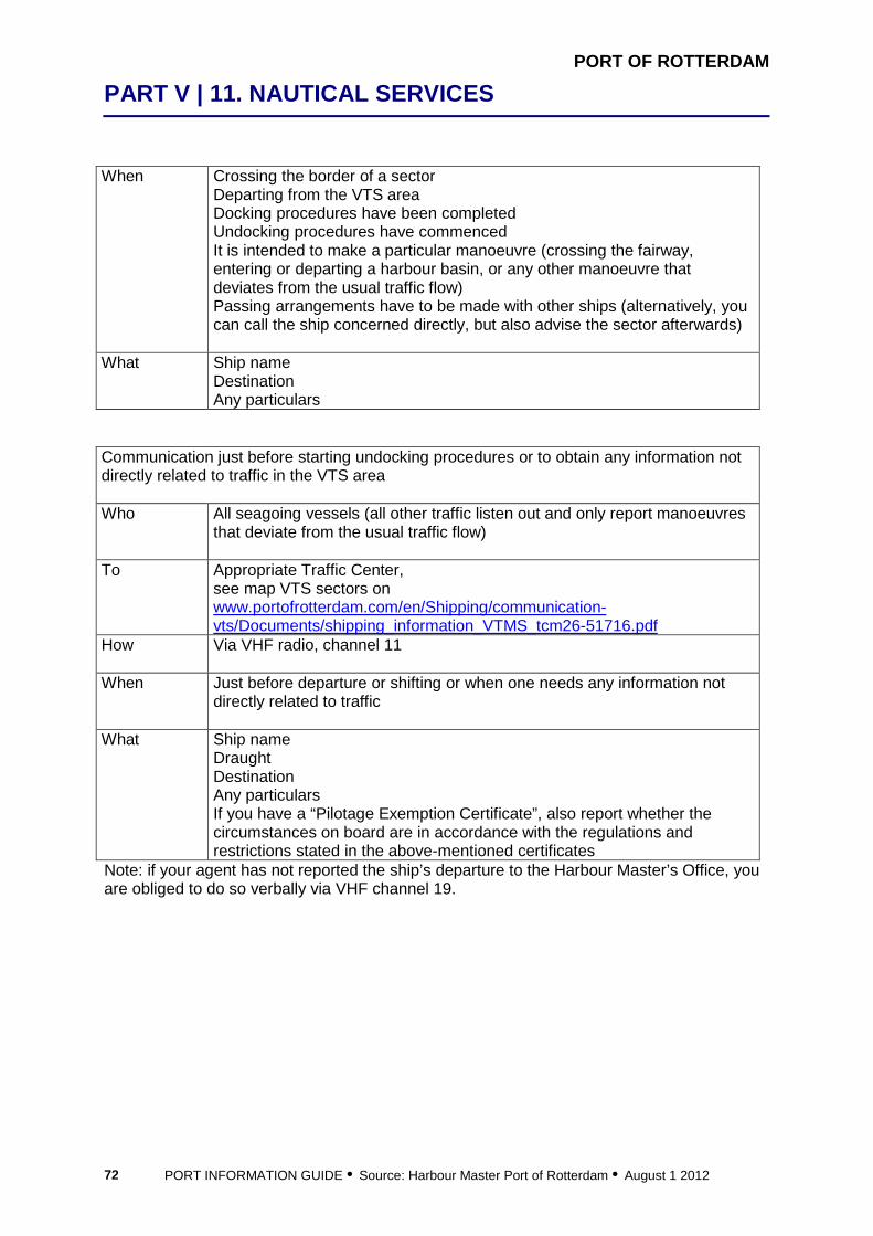
PORT OF ROTTERDAM
PART V | 11. NAUTICAL SERVICES
PORT INFORMATION GUIDE • Source: Harbour Master Port of Rotterdam • August 1 2012 72
When Crossing the border of a sector Departing from the VTS area Docking procedures have been completed Undocking procedures have commenced It is intended to make a particular manoeuvre (crossing the fairway, entering or departing a harbour basin, or any other manoeuvre that deviates from the usual traffic flow) Passing arrangements have to be made with other ships (alternatively, you can call the ship concerned directly, but also advise the sector afterwards)
What Ship name Destination Any particulars
Communication just before starting undocking procedures or to obtain any information not directly related to traffic in the VTS area Who All seagoing vessels (all other traffic listen out and only report manoeuvres
that deviate from the usual traffic flow)
To Appropriate Traffic Center, see map VTS sectors on www.portofrotterdam.com/en/Shipping/communication-vts/Documents/shipping_information_VTMS_tcm26-51716.pdf
How Via VHF radio, channel 11
When Just before departure or shifting or when one needs any information not directly related to traffic
What Ship name Draught Destination Any particulars If you have a “Pilotage Exemption Certificate”, also report whether the circumstances on board are in accordance with the regulations and restrictions stated in the above-mentioned certificates
Note: if your agent has not reported the ship’s departure to the Harbour Master’s Office, you are obliged to do so verbally via VHF channel 19.

PORT OF ROTTERDAM
PART V | 11. NAUTICAL SERVICES
PORT INFORMATION GUIDE • Source: Harbour Master Port of Rotterdam • August 1 2012 73
To maintain a listening watch when the ship is docked Who All ships To Harbour Coordination Center, VHF ch. 19.
How Via VHF radio, channel 19 When Always when the ship is docked. When gale force winds are expected
(Beaufort 8), weather forecasts are being transmitted at 00.50, 01.50, 02.50, etc.
What Only listen out, no reporting. To maintain a listening watch in case of an incident/emergency Who All ships
To When a ship is underway: to the appropriate sector via the appropriate
sector channel see map VTS sectors on www.portofrotterdam.com/en/Shipping/communication-vts/Documents/shipping_information_VTMS_tcm26-51716.pdf When a ship is alongside: via VHF radio channel 19
How When a ship is underway: via appropriate sector channel see map VHF sectors on www.portofrotterdam.com/en/Shipping/communication-vts/Documents/shipping_information_VTMS_tcm26-51716.pdf When a ship is alongside: via VHF radio, channel 19
When Always in case of an incident, when sirens sound What Only listen out, no reporting Note: For emergency scenarios in the port, see Port Safety, chapter 9. Communication at bridges and locks Who All ships To The bridge or lock concerned
On the appropriate channel of the bridge or lock concerned How See map Bridges & Locks on the website
www.portofrotterdam.com/en/Shipping/port-map/bridges-locks When When ship is coming trough What Continuous listening watch should be maintained
Inform the VTS operator when switching channel
11.3 PILOTAGE PILOTS The pilotage authority for the port of Rotterdam is the Regional Pilots Corporation Rotterdam-Rijnmond. The Pilots are supported by their company “Loodswezen Nederland BV”, which is responsible for equipment etc. More information on pilotage can be found on www.loodswezen.nl/.

PORT OF ROTTERDAM
PART V | 11. NAUTICAL SERVICES
PORT INFORMATION GUIDE • Source: Harbour Master Port of Rotterdam • August 1 2012 74
PILOT AREAS The pilot service for the Rotterdam-Rijnmond area includes Europoort, Rotterdam, Vlaardingen, Schiedam, Maassluis, Dordrecht, and Moerdijk. Is pilotage compulsory or not? To find out whether you need to order a pilot, please follow the decision tree below.
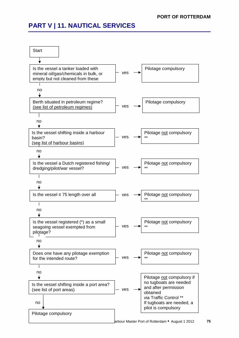
PORT OF ROTTERDAM
PART V | 11. NAUTICAL SERVICES
PORT INFORMATION GUIDE • Source: Harbour Master Port of Rotterdam • August 1 2012 75
Start
Is the vessel a tanker loaded with mineral oil/gas/chemicals in bulk, or empty but not cleaned from these
no
yesPilotage compulsory
Berth situated in petroleum regime? (see list of petroleum regimes) yes
Pilotage compulsory
no
Is the vessel shifting inside a harbour basin? (see list of harbour basins)
yes Pilotage not compulsory **
no
Is the vessel a Dutch registered fishing/ dredging/pilot/war vessel? yes
Pilotage not compulsory **
no
Is the vessel ≤ 75 length over all yes Pilotage not compulsory **
no
Is the vessel registered (*) as a small seagoing vessel exempted from pilotage?
yes Pilotage not compulsory **
no
Does one have any pilotage exemption for the intended route? yes
Pilotage not compulsory **
no
Is the vessel shifting inside a port area? (see list of port areas) yes
Pilotage not compulsory if no tugboats are needed and after permission obtained via Traffic Control ** If tugboats are needed, a pilot is compulsory
Pilotage compulsory
no

PORT OF ROTTERDAM
PART V | 11. NAUTICAL SERVICES
PORT INFORMATION GUIDE • Source: Harbour Master Port of Rotterdam • August 1 2012 76
Notes: * Registered means the vessel is acknowledged as a certain type of small vessel listed in a national register. Some of these types are exempted from pilotage. **Pilotage may be compulsory when: wind speed of 17.2 m/s and above visibility < 700 meters at any point along the intended sailing route available manoeuvring space concerning vessel traffic is restricted, for instance because of an accident, or traffic density is too high LIST OF AREAS Please find below a listing of harbours with a petroleum regime, harbour basins and port areas. List of harbours with a petroleum regime
List of harbour basins List of port areas
Beneluxhaven berth 104 (Shell) Brittanniëhaven south side Calandkanaal at ETT, Caldic and Chemtrade Chemiehaven Donauhaven Europahaven at Lyondell Geulhaven east side Neckarhaven Oude Maas, Odfjell Petroleumhaven no. 1 Petroleumhaven no. 2 Petroleumhaven no. 3 Petroleumhaven no. 4 Petroleumhaven no. 5 Petroleumhaven no. 6 Petroleumhaven no. 7 Petroleumhaven no. 8 Seinehaven east side St. Laurenshaven northwest side Tennesseehaven Torontohaven Vlaardingen at Vopak Welplaathaven central part Werkhaven no. 2 west part Wezerhaven
Amazonehaven Beneluxhaven Brittanniëhaven Eemhaven no. 1 Elbehaven Europahaven Keilehaven Koningin Wilhelminahaven Kousehaven Lekhaven Maashaven Merwehaven Parkhaven Prinses Beatrixhaven Prins Johan Frisohaven Prins Willem Alexanderhaven Rijnhaven Schiehaven Seinehaven St. Jobshaven St. Laurenshaven Torontohaven Vulcaanhaven Waalhaven East side Waalhaven West side Welplaathaven Werkhaven no. 1 Werkhaven no. 2 Wilhelminahaven Wiltonhaven IJselhaven
a) Europahaven, Amazonehaven, Mississippihaven b) Beneluxhaven c) Brittanniëhaven d) Botlek (St. Laurenshaven, Werkhaven no. 1 and no. 2, center fairway) e) Vlaardingen (Koningin Wilhelminahaven, Vulcaanhaven) f) Schiedam (Wiltonhaven, Wilhelminahaven) g) Eemhaven area (Heysehaven, Werkhaven) h) Waalhaven area (Waalhaven, Kortenoordsehaven) i) Merwehaven and Vierhaven area (Keilehaven, IJselhaven, Lekhaven, Koushaven) j) Rijnhaven, Maashaven k) Seaport area Dordrecht (Krabbegeul, Mallegat N/Z, Julianahaven and Wilhelminahaven) l) Central port to Eastern port of Moerdijk.
PORT OF ROTTERDAM
PART V | 11. NAUTICAL SERVICES
PORT INFORMATION GUIDE • Source: Harbour Master Port of Rotterdam • August 1 2012 77
HOW TO ORDER A PILOT When making notification ETA. See chapter 4. HOW TO CANCEL A PILOT Only the Master or the agent can cancel a pilot. If the call is made more than 1.5 hours before pilot on board time, no charges are involved. See Vessel Traffic & Operations chapter 2. WHEN DOES A PILOT EMBARK/DISEMBARK VIA HELICOPTER On arrival Ships with a draught of 17.4 meters and above: automatically, do not send any message other than the regular ones Ships with a draft of less than 17.4 meters, when pilotage via tenders has been amended: automatically, do not send a message, you will be notified by Maas Approach (VHF channel 01) if the pilot is to come on board via helicopter Ships that insist on taking the pilot on board by helicopter: send a message 12 hours before arrival at Maas Center buoy. Extra charges are involved, see below On departure Ships with a draught of more than 17.4 meters: automatically, do not send any message other than the regular ones Ships with a draught of less than 17.4 meters, when pilotage is amended: automatically, do not send a message, you will be notified by the pilot Ships that insist on embarking or disembarking the pilot via a helicopter: send a message 12 hours before departure, see below. Extra charges are involved HOW TO ORDER A HELICOPTER Contact Helipilot
Fax: +31 10 252 26 87 e-Mail: [email protected]
When 12 hours before arrival at Maas Center buoy or before departure Report Name of vessel
Call sign ETA at Maas Center buoy or ETD. Mention if boarding is possible via hoisting or landing
What signals must be displayed on arrival at the pilot station None HOW TO RECOGNIZE THE PILOT CUTTERS, TENDERS AND HELICOPTERS The pilot can come aboard the ship from the pilot cutter via a small tender, or straight from the shore via a large tender, Swath or helicopter. PILOT CUTTER Located one mile south of the Maas Center buoy: black vessel with yellow and white superstructure, with the word “Pilot” in white letters on either side
PORT OF ROTTERDAM
PART V | 11. NAUTICAL SERVICES
PORT INFORMATION GUIDE • Source: Harbour Master Port of Rotterdam • August 1 2012 78
SMALL TENDER Yellow open tender surrounded by a black fender LARGE TENDER Yellow tender with a white superstructure, with the word “Pilot” in black letters on either side Swath Twin hull yellow tender with a white superstructure, with the word “Pilot” in black letters on either side HELICOPTER The helicopter is yellow. It is sometimes replaced by a white one with red stripes. HOW TO COMMUNICATE WITH THE PILOT CUTTER, TENDERS AND SWATH Via sector channel “Pilot Maas”, VHF channel 02 HOW TO COMMUNICATE WITH THE HELICOPTER Via sector channel “Maas Approach”, VHF channel 01 or “Pilot Maas”, VHF channel 02, depending on the ship’s position. Directions from helicopter to the ship via VHF channel 09 if necessary. The vessel must advise the helicopter pilot of its position, course, speed (when underway), the actual wind direction and speed over the deck, pitch, roll and condition of deck (e.g. spray, wet, etc.). The helicopter pilot will confirm the acceptability of those conditions, or ask for a possible change in heading and/or speed.

PORT OF ROTTERDAM
PART V | 11. NAUTICAL SERVICES
PORT INFORMATION GUIDE • Source: Harbour Master Port of Rotterdam • August 1 2012 79
HOW TO PREPARE THE SHIP FOR BOARDING OF THE PILOT Pilots will board the vessel in line with ICS Standard Regulations and International Maritime Pilots’ Association Regulations. By tender Vessels with a freeboard of over 9.0 meters must provide an
accommodation ladder in addition to the pilot ladder Generally, pilots refuse to use mechanical pilot hoists or other constructions that do not comply with the above-mentioned regulations
By small tender Pilot ladder 2 feet above the water, speed 4 knots By large tender Pilot ladder 6 feet above the water, speed 5-6 knots By Swath Pilot ladder to be adjusted according instructions, speed 8-10 knots By helicopter Pilots will board by hoist cable, or, if the vessel is equipped with full
landing gear, the helicopter will land on deck Winch is located on starboard side of the heli, so normally hoisting operations on portside of the vessel Instruction to the crew: never touch the line or the pilot pilots do not require assistance during the hoisting procedure. Just stay well clear of the line and the pilot the location for boarding the pilot is at the discretion of the helicopter pilot, and depends on the type of ship if the location is the bridge wing, remove the rubber mats (so the helicopter line can make contact with steel) Restrictions: - minimum visibility 800 meters, at 46 meters above sea level - maximum wind force 10 (55 knots) - severe turbulence and icing conditions at or below 46 meters above sea level Major course changes should be avoided during the hoisting and landing operations.
PILOT STATIONS Boarding station for ships with draught between 0 and 14.29 meters By small or large tender 4 miles west southwest of Maas Center bouy, 51°59.0’N, 003°47.2’E, 1 pilot boarding By helicopter, for ships coming from the north: in the southbound lane of TSS Maas North, exact position will be advised via VTS, 1 pilot boarding By helicopter, for ships coming from the west: in the eastbound lane of TSS Maas West Inner / Outer, exact position will be advised via VTS, 1 pilot boarding The decision on whether the pilot comes on board via a tender or helicopter is made by the pilot. If pilotage is amended, no additional costs will be charged fur using the helicopter.
PORT OF ROTTERDAM
PART V | 11. NAUTICAL SERVICES
PORT INFORMATION GUIDE • Source: Harbour Master Port of Rotterdam • August 1 2012 80
Boarding station for LNG carriers Between bouy E9 and E11 in the Eurogeul. Boarding station for ships with draught between 14.30 and 17.39 meters By small or large tender or by helicopter, west of the E13 buoy, in the Eurogeul, exact position will be advised via VTS, 1 pilot boarding. The decision on whether the pilot comes on board via a tender or helicopter is made by the pilot. If pilotage is amended, no additional costs will be charged fur using the helicopter. Boarding station for ships with a draught between 17.40 and 22.55 meters At rendezvous point 51°59.0’N, 003°00.0’E..2 pilots boarding by helicopter. Disembarkation station for ships with draught between 0 and 14.29 meters Pilot will disembark at the MO buoy. Disembarkation station for LNG carriers Pilot will disembark at the MNW3-MW6 bouy Disembarkation station for ships with draught between 14.30 and 17.39 meters Pilot will disembark after passing the MO buoy. Disembarkation station for ships with a draught between 17.40 and 22.55 meters Pilot will disembark at the Euro buoy. WHAT HAPPENS WHEN PILOTAGE BY TENDERS IS AMENDED When pilotage is amended it will either be “amended for small shipping”, or “completely amended”. As a rule, a wave height of about 2 meters will result in pilotage being “amended for small shipping”. A wave height of 2.7 meters is the critical height for complete suspension. There are three options: 1) The pilot comes on board by helicopter Sector Maas Approach will ask automatically if the ship can accept a pilot on board via helicopter: - daytime: ships longer than 125 meters - nighttime: ships longer than 150 meters 2) Ship will be guided via Shore Based Pilotage, if boarding via helicopter is impossible 3) Ship needs to wait (go at anchor or stem the current) SHORE BASED PILOTAGE (SBP) UNDER WHAT CIRCUMSTANCES WILL SHORE BASED PILOTAGE BE GIVEN? If pilotage has to be amended, which will normally happen when the sea conditions make boarding by tender or helicopter hazardous, Shore Based Pilotage can be provided. Instructions will be given till the ship is inside the breakwaters, where the pilot will board. Shore Based Pilotage is provided only when: required and accepted by the master of the vessel allowed by the Harbour Master or his representative and the pilot rendering the Shore Based Pilotage considers it possible

PORT OF ROTTERDAM
PART V | 11. NAUTICAL SERVICES
PORT INFORMATION GUIDE • Source: Harbour Master Port of Rotterdam • August 1 2012 81
WHERE Shore Based Pilotage is only available between the normal pilotage boarding position at Maas Center buoy and the Maas Entrance off the Traffic Center Hook of Holland (51°58.9’N, 004°06.8’E). EXCLUDED VESSELS Sea-going vessels with a draught of more than 14.30 meters Sea-going vessels which, in view of their condition, are required by the competent authority to use an on-board pilot Sea-going vessels that are incapable of adequate communication Sea-going vessels for which it is determined, or has been determined, that SBP can not be used safely Sea-going tanker vessels with a length of more than 125 meters Sea-going tanker vessels with a length of less than 125 meters which are carrying dangerous goods in bulk corresponding to IMO classes 2,6 and 3 (inflammable liquids whose lower flash point is equal to, or less than 55 degrees Celsius, and where such liquids are immiscible with water at all ratios) If the captain does not have an adequate knowledge of Dutch or English and if he has not called in at Rotterdam an average of at least twelve times over the previous two years (of which at least 6 times in the last year) Vessels heading out to sea with a length of more than 125 meters and / or with a draught of more than 9 meters Sea-going vessels which it is reason able to assume could be piloted by helicopter under the above mentioned conditions For vessels approaching from the sea with a length of more than 125 meters and / or a draught of more than 9 meters which are eligible for SBP, the time of entry is dependent on the prevailing hydro-meteorological conditions. The above shall be without prejudice to the fact that, taking all circumstances into account, any vessel can be denied access to SBP, either permanently or for a given period of time. Particularly vessels with a length of more than 170 meters and/or with a draught of more than 9 meters should take the latter point into account. HOW IS SBP PROVIDED Advices will be given by a pilot via VTS sector Pilot Maas (VHF channel 02) or Maas Entrance (VHF channel 03). Advices will consist of gyro course (already corrected for drift, so do not steer a different course) speed (through the water) or a telegraph setting additional information if necessary The master making use of SBP must report to the pilot immediately: on the reception of all advice, repeating all courses and speeds and any other advice required when and how he deviates from the advice given by the pilot Pilot boarding and disembarking location In all cases the pilot will board and disembark via a large tender. Ships might be asked to reduce speed when a pilot tender is embarking or disembarking a pilot at another ship, to avoid waves.

PORT OF ROTTERDAM
PART V | 11. NAUTICAL SERVICES
PORT INFORMATION GUIDE • Source: Harbour Master Port of Rotterdam • August 1 2012 82
Arrival Ships destined for Europoort will receive the pilot on board close to buoy Maas 5, pilot ladder on starboard side (always) Ships with destination Nieuwe Waterweg will receive the pilot on board close to buoy NW7, pilot ladder on starboard side (always) Departure Ships coming from the Nieuwe Waterweg will disembark the pilot close to buoy NW6. Ships coming from the Europoort will disembark the pilot close to buoy CA6. DEEP SEA PILOTAGE Ships that want to use Deep Sea Pilotage for navigational assistance because of nautical, weather, and traffic conditions. Over 400 vessels pass the Dover Strait daily, not including ferries and fishing vessels, which gives some indication of the high traffic density in this area. Together with the numerous days of bad weather and bad visibility, this sea area is one of the most dangerous in the world. HOW TO ORDER DEEP SEA PILOTAGE Contact Dirkzwager’s Coastal and Deep Sea Pilotage
Telephone: +31 10 593 16 00 Fax: +31 10 592 57 67 e-Mail: [email protected] SATCOM 26751 (dirk nl) TELEX 21058 (dirk nl)
When 48 hours before arriving at pilot station Cherbourg or Brixham Report Name of ship
Final destination ETA Cherbourg or Brixham Local Time Maximum draught in meters and centimetres
WHERE DOES THE PILOT BOARD Usual point of rendezvous Brixham, 1.5 nautical miles E of Berry Head, 4.5 nautical miles E of Berry Head for deep draught vessels (17.4 meters and above) Usual point of rendezvous Cherbourg, 1 nautical mile E of CH-1 buoy, 7 nautical miles N of the breakwaters for tankers. Moreover, tankers and other deep draught vessels can embark the pilot by helicopter in the following positions: R/V position Alpha, 13 nautical miles N of Cap de la Hague, and R/V position Bravo, 10 nautical miles N of Cap Levy In any port in North West Europe HOW TO RECOGNIZE THE PILOT TENDER OR HELICOPTER Brixham helicopter: Brixham has no helicopter Brixham tender: orange hull, orange superstructure, the word “Pilot” in black letters Cherbourg helicopter: a navy helicopter Cherbourg tender: black hull, white superstructure, the word “Pilot” in black letters

PORT OF ROTTERDAM
PART V | 11. NAUTICAL SERVICES
PORT INFORMATION GUIDE • Source: Harbour Master Port of Rotterdam • August 1 2012 83
COMMUNICATION WITH THE PILOT TENDER OR HELICOPTER Brixham: 2 hours before arrival at the pilot station call “Brixham pilots” on VHF channel 9 Cherbourg: 4-6 hours before arrival at the pilot station call “Jobourg” on VHF channel 13. After this call, 2 hours before arrival at the pilot station call “Cherbourg signal station” on VHF channel 16 Note: the use of Deep Sea Pilots is not compulsary PILOTAGE EXEMPTION CERTIFICATE (PEC) Bona fide Masters and First Mates of ships regularly calling at Rotterdam may obtain a Pilotage Exemption Certificate for Rotterdam subject to their being able to satisfy Rotterdam Port Authority as to their skill, experience, local knowledge, knowledge of English and medical fitness. “Ecxperience”in the pilotage area in this case should be considered as completing a minimum of 18 trips under a pilot annually. For any additional information please contact the Harbour Coordination Center (HCC), phone: +31-10-252-1000 (see also chapter 2)
11.4 TUGS If you do not have a pilot on board and wish to use tugs, you might nonetheless consider requesting a pilot, because pilots are very skilled in directing tugboats. TUGS AVAILABLE The number of tugs may vary throughout the year, and the numbers mentioned below are averages. Bollard pull 28 – 45 Tons: 13 Bollard pull 50 – 65 Tons: 15 Bollard pull 70 – 80 Tons: 5 Tugboat types: conventional, ASD-type and tractor tugs. All the tugs are equipped with proper rubber fenders on the front and the stern. HOW TO ORDER A TUGBOAT Via communication procedure Via the pilot or your agent Via Vessel Traffic & Operations, see chapter 2 RENDEZVOUS POINTS Ships with destination Rendezvous point Yangtzehaven, Europahaven, Amazonehaven, Hartelhaven, Petroleumhaven no. 6
close to 51°59.0’N, 004°04.0’E
Beneluxhaven, Petroleumhaven nos. 4, and 5
close to 51°58.5’N, 004°06.0’E
Britanniëhaven and Petroleumhaven no. 7 close to 51°56.5’N, 004°10.0’E Werkhaven no. 2, St. Laurentshaven, Chemiehaven, Peutroleumhaven nos. 1,2 and 3
close to 51°55.0’N, 004°15.0’E
Eemhaven no. 1, Prins Johan Frisohaven, Prinses Beatrixhaven, Prins Willem Alexanderhaven, Waalhaven, Merwehaven, Wilhelminahaven
close to 51°53.7’N, 004°20.0’E

PORT OF ROTTERDAM
PART V | 11. NAUTICAL SERVICES
PORT INFORMATION GUIDE • Source: Harbour Master Port of Rotterdam • August 1 2012 84
HOW TO CONNECT A TUGBOAT On arrival of the tugs the captain of the tugboat and the captain of the ship to be assisted will discuss where the tugs will be made fast, depending on available type of tugboats and type of maneuver. If your ship has a special place at the ships side for a tug to push, inform the tug master. Mention the location clearly: Forward: center lead forward, starboard/portside shoulder Aft: center lead aft, starboard/portside quarter The normal way of towing in Rotterdam is that the tug will use its own line from the towing winch. The towing line comes from the tugs for or aft winch depending on the type of tug. Towing on the winch makes the tug very flexible. Depending on the situation the tug will adjust the length of the towline. A short towline gives a quicker reaction. Keep ready extra heaving lines, as the heaving line needs to be throwed to the tugboat (and therefore needs a monkey fist). The extra heaving lines can be used in case the first throw misses. Don’t add any weight to the normal weight of the monkey fist as this is a danger to the crew on the tug boat. The tugboat crew will connect a messenger line to the heaving line, which can be heaved in by hand to speed up the operation. The messenger line can be put on the gypsy head to heave in the real tug line. Be aware that when you tie up a tug at the bow, that a tug operating under the bow of a ship involves a risk, due to the interaction affects and the risk will increase with a higher ship’s speed. Recommended speed to be not more than 4 knots. In other positions the tug can be tied up with a speed of 6 knots maximum. Avoid starting and stopping of the engine and avoid maximum rudder. If the tug boat has slack on its line, and the ship’s crew is in the process of connecting the tug line, the wash of the propeller will effect the tug’s manoeuvrability, and the line might become tight again. This is a big risk for the ship’s crew. For this reason try to keep a constant speed. HOW TO COMMUNICATE WITH A TUGBOAT Maintain good communication at all times. Advise the Captain of the tugboat about your intended maneuver. Specially engine orders need to be relayed very clear. Keep the communication short and clear. Remember that the Captain of the tugboat is responsible for his own vessel and crew and will act accordingly when necessary. So when your ship makes an unexpected maneuver, and the Captain of the tugboat gets trapped, he will let go his line to safe his ship and crew On VTS sector channel you can arrange a working channel with the tug, which will normally be VHF channel 6 or 8 The pilots work on different channels with the tugs If you use boatmen, use the same working channel for tugs and boatmen When working with more than one tug: first call one tug and give an order; wait for the confirmation of the first tug before calling the second tug

PORT OF ROTTERDAM
PART V | 11. NAUTICAL SERVICES
PORT INFORMATION GUIDE • Source: Harbour Master Port of Rotterdam • August 1 2012 85
FIRST ORDER MUST INCLUDE • Name of tugboat • Action (pull/push/swing/connect/disconnect) • Direction (port/starboard/location) • Power in tons
E.g.: Loire push to starboard 10 tons E.g.: Loire make fast center lead forward SECOND ORDER (AS LONG AS ACTION AND DIRECTION DO NOT CHANGE)
• Name of tugboat • Power in tons
E.g.: Loire 10 tons HOW AND WHERE TO DISCONNECT A TUG BOAT First bring the vessel in the main fairway channel before letting the tug(s) go. Never let go the tug(s) too early. Never let go the tug when making way over the stern. When the tug is using its own towing wire be aware that you can let go the tugs line only, when the tug is in such a position not to foul its own propeller. When using two tugs, first let go the tug aft so you will be able to use your propulsion again. Remind the sailors to lower the line slowly, pay attention to instructions from the crew of the tug boat. The larger the tug, the heavier its equipment, the more difficult it is to handle the line. Avoid starting and stopping of the engine and avoid maximum rudder. If the tug boat has slack on it’s line, and the ship’s crew are in the process of letting go the tug line, the wash of the propeller will effect the tug’s manoeuvrability, and the line might become tight again. This is a big risk for the ship’s crew. Try to keep a constant speed Shift the position of the tubboat when there’s sufficient room or when wind conditions are more favourable TUG LINE STAND BY FOR EMERGENCY Seagoing vessels with a length of more than 120 meters must have a line stand by on the forward mooring deck for connecting a tug in case of emergency.
11.5 MOORING If the ship is in one of the following categories, use of the services of the boatmen or of the ship’s crew to secure the lines is compulsory: • ships longer than 75 meters • tankers Exemption: if the ship is shifting along the same pier, without letting go all lines. GENERAL MOORING PROCEDURES IN THE PORT OF ROTTERDAM In the Port of Rotterdam, in particular for the larger vessels, mooring boats are used to speed up the mooring process and can be used in case of emergency (i.e. malfunctioning bowthruster etc.) These mooring boats are robust, powered by engines up to 200 hp and can sail at a speed of 10 knots. They are also equipped with direct radio communication with the pilot, and fitted with watertight compartments. Ropes are secured with a special hydraulic clamp for extra safety.
PORT OF ROTTERDAM
PART V | 11. NAUTICAL SERVICES
PORT INFORMATION GUIDE • Source: Harbour Master Port of Rotterdam • August 1 2012 86
On the shore side boatmen are equipped with special winch cars, fitted with a hydraulic winch with a SWL of 1,2 Tons and spot lights for berthing at night time. This winch car can also assist with bringing the ship’s gangway in position. RULES FOR MOORING IN GENERAL
• Breast lines should be oriented as perpendicular as possible to the longitudinal centre line of the vessel and as far aft and forward as possible
• Spring lines should be oriented as parallel as possible to the longitudinal centre line of the vessel
• The vertical angle of the mooring lines should be kept to a minimum • Generally, mooring lines of the same size and type (material) should be used for all
leads. If this is not possible due to the available equipment, all lines in the same service, i.e. breast lines, spring lines, head lines, etc. should be the same size and type. For example, all spring lines could be wire and all breast lines synthetic.
• Mooring lines should be arranged so that all lines in the same service are about the same length between the vessel’s winch and the shore bollard. Line elasticity varies directly with line length and shorter lines will assume more load.
RULES FOR MOORING ON BUOYS When mooring on a buoy span the vessel should moor with her bow heading into the wind and make use of a minimum of 1 anchor. Be aware that in Rotterdam the boatmen use lashings to secure the mooring lines on the buoys. REQUIRED ROOM FOR MOORING Seagoing vessels with a length of 120 meters or less must have at least 0,1 x length over all room for mooring, with a minimum of 10 meters. Seagoing vessels with a length of more than 120 meters must have at least 0,1 x length over all room for mooring, with a minimum of 15 meters and a maximum of 35 meters. GUIDELINES FOR MOORING FOR TERMINAL OPERATORS Terminal operators are encouraged to prepare and publish mooring plans in relation to the position of the vessel ahead of time, giving Masters/pilots/boatmen the opportunity to make preparations Terminal operators must understand that the Master of the vessel is end-responsible for ensuring that the vessel is safely moored, and allow sufficient space to do so (see required room for mooring). It speeds up the mooring process if the terminal operator is stand by on the quay when the vessel comes alongside to indicate the exact position of the vessel by using the (storno) radio. EMERGENCY TOWING OFF PENDANTS (ETOPS OR FIRE WIRES) This item is still on the ISGOTT checklist. However, as OCIMF advises to discontinue this practice, this item is not being enforced in the Port of Rotterdam. ORDERING You can order mooring services via VHF ch. 19.
PORT OF ROTTERDAM
PART V | 11. NAUTICAL SERVICES
PORT INFORMATION GUIDE • Source: Harbour Master Port of Rotterdam • August 1 2012 87
11.6 LASHING OF CARGO LASHING OF CARGO Lashing of containers on board of a seagoing vessel is only allowed if the crew is working under the responsibility of a licensed lashing company, or if the crew is a qualified member of the crew of the concerned vessel. If the seagoing vessel has a length of 170 meters or more, only crew working under the responsibility of a licensed lashing company is allowed to do this job.


12 Nautical Communication
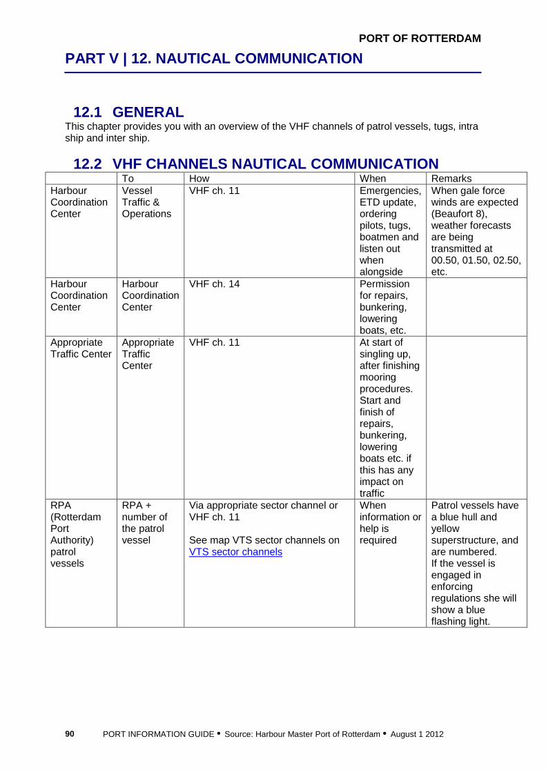
PORT OF ROTTERDAM
PART V | 12. NAUTICAL COMMUNICATION
PORT INFORMATION GUIDE • Source: Harbour Master Port of Rotterdam • August 1 2012 90
12.1 GENERAL This chapter provides you with an overview of the VHF channels of patrol vessels, tugs, intra ship and inter ship.
12.2 VHF CHANNELS NAUTICAL COMMUNICATION To How When Remarks Harbour Coordination Center
Vessel Traffic & Operations
VHF ch. 11 Emergencies, ETD update, ordering pilots, tugs, boatmen and listen out when alongside
When gale force winds are expected (Beaufort 8), weather forecasts are being transmitted at 00.50, 01.50, 02.50, etc.
Harbour Coordination Center
Harbour Coordination Center
VHF ch. 14 Permission for repairs, bunkering, lowering boats, etc.
Appropriate Traffic Center
Appropriate Traffic Center
VHF ch. 11 At start of singling up, after finishing mooring procedures. Start and finish of repairs, bunkering, lowering boats etc. if this has any impact on traffic
RPA (Rotterdam Port Authority) patrol vessels
RPA + number of the patrol vessel
Via appropriate sector channel or VHF ch. 11 See map VTS sector channels on VTS sector channels
When information or help is required
Patrol vessels have a blue hull and yellow superstructure, and are numbered. If the vessel is engaged in enforcing regulations she will show a blue flashing light.

PORT OF ROTTERDAM
PART V | 12. NAUTICAL COMMUNICATION
PORT INFORMATION GUIDE • Source: Harbour Master Port of Rotterdam • August 1 2012 91
Seaport Police
Seaport Police + number of patrol vessel
Via appropriate sector channel in traffic situations. If you require a patrol boat in emercency situations, contact Vessel Traffic & Operations via VHF 19 See map VTS sector channels on VTS sector channels
When information or help is required
Patrol vessels of the Seaport Police have a blue hull and white superstructure. If the vessel is engaged in enforcing regulations she will show a blue flashing light.
Tugboats VHF channels 6 or 8 See also chapter 11.4
Intra ship VHF communication on a ship: VHF channels 15 or 17
Inter ship For communication regarding social matters: VHF channel 77. For communication regarding traffic, manoeuvring and so on, use the appropriate sector channels. See map VTS sector channels on VTS sector channels
Inter ship for barges
VHF channel 10 – if a barge does not respond on the sector channel, try channel 10. Channel 10 is also used for all areas without sector channel coverage.
www.portofrotterdam.com/en/Shipping/communication-vts/Documents/shipping_information_VTMS_tcm26-51716.pdf


13 Cargo Operations

PORT OF ROTTERDAM
PART VI | 13. CARGO OPERATIONS
PORT INFORMATION GUIDE • Source: Harbour Master Port of Rotterdam • August 1 2012 94
13.1 GENERAL This chapter describes the rules and regulations concerning cargo operations in the port of Rotterdam. Furthermore, the checklists mentioned in this chapter give concrete and clear insight into the cargo procedures.
13.2 LOADING/DISCHARGING PROCEDURES It is prohibited to permit the transfer of dangerous or noxious substances between a seagoing tanker and an installation unless care has been taken in the installation and on board the seagoing tanker in question, prior to the transfer, that:
• all elements of the seagoing vessel/terminal safety checklist have been completed in full and truthfully, and
• the seagoing vessel/terminal safety checklist has been signed by the persons responsible from the installation and the seagoing tanker involved in the transfer of a dangerous or noxious substance.
It is prohibited to permit the transfer of dangerous or noxious substances between tankers unless care has been taken on board the tankers in question, prior to the transfer, that:
• all elements of the seagoing vessel/seagoing vessel safety checklist has been completed in full and truthfully, and
• the seagoing vessel/seagoing vessel safety checklist has been signed by the persons responsible from the tankers involved in the transfer of a dangerous or noxious substance.
• In the situations referred to in paragraphs 1 and 2: • during the transfer of a dangerous or noxious substance and for as long as the tanker
in question is berthed there, the installation or tankers involved shall comply with the terms of the safety checklists as referred to in paragraphs 1 and 2
• the transfer of a dangerous or noxious substance shall be halted immediately if there is a failure to comply with the terms of the safety checklists as referred to in paragraphs 1 and 2 by either the installation involved in the transfer or the tanker in question
During the transfer of a dangerous or noxious substance, use shall be made of a vapour return line if the transfer takes place between:
• seagoing tanker and inland tanker and pursuant to the Bulk Chemical Code or the transport regulation for inland barges , the noxious or dangerous substance must be transported in a tank with a connection for a vapour return line or be transported in closed conditions;
• seagoing tanker and seagoing tanker and pursuant to the Bulk Chemical Code the noxious or dangerous substance must be transported in a tank with a connection for a vapour return line;
• inland tanker and inland tanker and pursuant to the transport regulation for inland barges, the noxious or dangerous substance must be transported in closed conditions;
• tankships and substances mentioned in the list of substances causing stench or hindrance are involved;
• tankships and substances mentioned in Annex 3 of the port regulations The transfer of gas as referred to in the Gas Carrier Code or the ADN (transport regulations for inland barges) between two tankers is prohibited.
PORT OF ROTTERDAM
PART VI | 13. CARGO OPERATIONS
PORT INFORMATION GUIDE • Source: Harbour Master Port of Rotterdam • August 1 2012 95
It is prohibited to berth a ship or lie at berth alongside a ship that is involved in the transfer of a gas as referred to in the Gas Carrier Code or the ADN (transport regulations for inland barges) It is prohibited for anyone to handle a dangerous or noxious substance, whether or not simultaneously with the cleaning of cargo tanks, unless it is possible to intervene in these procedures immediately. It is prohibited to berth alongside a tanker that is involved in the handling of a dangerous or noxious substance if, as a result, more than two ships are berthed widthwise, unless: by one single supply vessel, as long as this is moored outside the tanker’s cargo zones, or by a single bunker vessel. The fixed connection points for cargo hoses of vessels involved in the transfer of a dangerous or noxious substance shall be connected to each other over the smallest possible distance.
• It is prohibited to: • transfer a dangerous or noxious substance unless the permanent ship’s cargo hose is
used, and • unload a dangerous or noxious substance from a vessel unless the permanent
vessel’s discharge pump is used. Reporting the loading of dangerous and noxious substances See chapter 4.8
13.3 CLEANING PROCEDURES It is possible to clean the vessel’s holds or tanks in the port of Rotterdam . This section describes the procedures. WASHING AND CLEANING CARGO TANKS During the washing of a tanker’s cargo spaces with crude oil:
• the material and equipment used shall comply with the COW manual • washing will be done in accordance with that manual, and • within the tanker’s cargo zone, no more than two ships may moor alongside, which, at
the least, comply with the requirements of the ADN (transport regulations for inland barges).
During the cleaning, other than washing with crude oil, of a tanker’s cargo spaces which contain or have until recently contained dangerous liquids, berthing may only take place alongside the tanker:
• by a ship that is taking over a prewash or cargo residues, as referred to in the P&A manual of the vessel
• by no more than two tankers if the cleaning is taking place in closed conditions As long as the tankers referred to in paragraph 2, sub b, are berthed alongside, the tanker is prohibited from opening the cargo tanks after cleaning in closed conditions unless the tank atmosphere is below twenty percent of the lowest explosion level or the tank atmosphere is below the limit as mentioned in the TLV list from the substance last carried in the cargo tank. The Municipal Executive may restrict or forbid the cleaning and if atmospheric conditions are such that they could cause danger, damage or hindrance due to the release of the substances in question in these conditions. It is prohibited to clean the cargo tanks of a tanker carrying liquefied gases unless the ship is berthed alongside an installation that has a licence granted by the competent authority
PORT OF ROTTERDAM
PART VI | 13. CARGO OPERATIONS
PORT INFORMATION GUIDE • Source: Harbour Master Port of Rotterdam • August 1 2012 96
pursuant to the ‘Wet Milieubeheer’ (Environmental Management Act) for carrying out the cleaning work and this installation accepts the residues of the liquefied gases. The cleaning of cargo tanks in closed conditions on board a tanker is only allowed if the tanker is appropriately equipped and the cleaning takes place in accordance with the cleaning handbook as referred to in MARPOL. It is prohibited to clean cargo tanks which contain residues of dangerous or noxious substances on board of a tanker if:
• a seagoing tanker is involved and the substances must be transported, pursuant to the Bulk Chemical Code, in a tank with a connection for a vapour return line, or
• substances mentioned in the list of substances causing stench or hindrance are involved, or
• benzene, benzene mixtures having 10% benzene of more, formaldehyde (37%) or styrene is involved, unless:
o the tanker is washed in closed conditions and no gas or vapour escapes into the open air as a result of the cleaning operations except over a short period during the start of the drying of the tank, or
o the tanker is berthed alongside an installation that has a licence granted by the competent authority for carrying out the cleaning work and which accepts the vapours released by the cleaning operations.
Reporting the washing and cleaning of cargo tanks Who
• All seagoing vessels with the intention to clean or wash cargo tanks • What • the official name and call-sign of the ship • the nationality and home port of the ship • the agent, owner or charterer of the ship • the date and time of commencement of the washing or cleaning operations • the berth in the port during washing or cleaning • the spaces of the ship which are to be washed or cleaned • the chemical or technical name of the substances which the areas to be
cleaned contain or until recently contained, and • the washing or cleaning method to be used.
To • Harbour Master
How • EDI*
When • Prior to the washing and cleaning
Remarks • The report is not required if only drying is involved. • The time at which the compulsory prewash of a tank, in accordance with Marpol
Annex II, from which a noxious liquid has been discharged and which must be prewashed commences shall be reported to the harbour master at least 30 minutes and no more than 2 hours prior to the prewashing.
An overview of service providers on tank cleaning and gas freeing can be found on www.rotterdamportinfo.com/results.cfm?sbranch=Equ

PORT OF ROTTERDAM
PART VI | 13. CARGO OPERATIONS
PORT INFORMATION GUIDE • Source: Harbour Master Port of Rotterdam • August 1 2012 97
FREIGHTERS AND BULK CARRIERS The holds of a freighter or bulk carrier may always be cleaned, provided that the refuse or cargo residues stay on board or will be disposed of at a port reception facility. See also chapter 16.6 Waste. More information on Port Reception Facilities can be found on www.portofrotterdam.com/en/shipping/sea-shipping/Pages/waste-disposal.aspx The waste disposal guide and the IMO complaint form can also be downloaded from the website.


14 Vessel Operations

PORT OF ROTTERDAM
PART VI | 14. VESSEL OPERATIONS
PORT INFORMATION GUIDE • Source: Harbour Master Port of Rotterdam • August 1 2012 100
14.1 GENERAL From cleaning a vessel to underwater inspections, this section contains information on the rules and regulations regarding ship operations in the port of Rotterdam area. Not permitted in the port of Rotterdam:
• use of an incinerator • bottom cleaning by brushes (exemption can be given, see 14.4) • fishing without a permit (from the municipality)
Permitted in the port of Rotterdam:
• painting, provided measures are in place to prevent spillage into the water • cleaning exterior, provided environmentally-friendly soap is used • use of speaker systems on outside decks • polishing propellers by a specialized, approved company • bottom cleaning of hulls coated with Ecospeed® hull protection system (see 14.4)
In line with international regulations the maximum sulphur content may not exceed the following values: 1.50% until July 1 2010, 1.00% from July 1 2010, 0.10% from January 1 2015. Sulphur scrubbing will be an acceptable method for compliance. So fuel with a higher sulphur content may be used as long as the sulphur oxides are removed from the exhaust gas to a level comparable to low sulphur fuel. In addition the European Union’s Marine Fuel Sulphur Directive also introduced a 0.1% maximum sulphur requirement for fuels used by ships at berth, buoy arrays and dolphin constructions (within 2 hours after mooring) in EU ports from January 1 2010.
14.2 LOWERING BOATS AND RAFTS Before lowering boats and rafts contact Harbour Coordination Center. See chapter 2. When actually lowering boats and rafts contact the appropriate Traffic Center on VHF ch. 11.
14.3 MAINTENANCE AND REPAIR The requirement to report repairs or request permission depends on the nature of the repairs and the location of the ship in the port. Two different types of repair are distinguished: Cold work - repairs not involving and with no risk of fire or sparks These repairs need to be reported to the Harbour Coordination Center if:
• the vessel is temporarily immobilized • the repairs are performed on a tanker that is or has been loaded with dangerous
goods To request such a permit, contact the Harbour Coordination Center, see chapter 2 or download the form on www.portofrotterdam.com/en/Shipping/contact-support/Pages/forms-checklists.aspx Hot work - repairs involving or with a risk of fire or sparks Before starting these repairs, a permit from the Harbour Coordination Center is compulsory for:
• all tankers • all ships that are or have been loaded with dangerous goods • hot work in engine rooms or ballast and other tanks for all other ships • ships located in a Petroleum harbour: see berths for the list of Petroleum harbours

PORT OF ROTTERDAM
PART VI | 14. VESSEL OPERATIONS
PORT INFORMATION GUIDE • Source: Harbour Master Port of Rotterdam • August 1 2012 101
Note: in those ports where the so-called ‘Petroleum harbour regime’ is in force, it is prohibited to cause open fire. On completion of the job report again. See chapter 11.3 for a list of Petroleum harbours. To request such a permit, contact the Harbour Coordination Center see chapter 2 or download the form on www.portofrotterdam.com/en/Shipping/contact-support/Pages/forms-checklists.aspx Exceptions to these regulations apply if: a ship is in a shipyard or other area that has a permit to carry out the work concerned permission has been granted by the Harbour Coordination Center. In addition, an operational report to the Harbour Coordination Center is required. Your agent should take care of this. This report shall contain: name of ship, date of commencement of repairs, duration of repairs, berth, nature of repairs, location of repairs, by whom repairs will be carried out, any cargo operations, bunkering etc. during repairs, cargo on board and stowage, effect of repairs on ship’s manoeuvrability and time and duration of immobilized situation. See chapter 2 on contacting the Harbour Coordination Center.
14.4 UNDERWATER INSPECTION/ CLEANING Inspection activities outboard or under water and requests for exemptions must be reported to the Harbour Coordination Center. This report or request shall contain: name of ship, date, name and number of berth, place at or near the ship and the nature of the activities, expected duration of activities, reason. On completion of before mentioned inspection, report again. See chapter 2 on contacting the Harbour Coordination Center. Underwater cleaning of a vessel is allowed provided that the hulls is coated with Ecospeed® hull protection system and the Directorate General for Public Works and Water Management (RWS) and the local berth operator have granted permission. An officially appointed company can also perform the cleaning of a propeller. In the port of Rotterdam only a few companies are permitted to perform this operation.


15 Port Inspections
PORT OF ROTTERDAM
PART VI | 15. PORT INSPECTIONS
PORT INFORMATION GUIDE • Source: Harbour Master Port of Rotterdam • August 1 2012 104
15.1 GENERAL This chapter describes all relevant inspections that one can expect in the port of Rotterdam.
15.2 INSPECTIONS FROM PORT STATE CONTROL The Paris Memorandum of Understanding (MOU) on Port State Control aims at eliminating the operation of sub-standard ships through a harmonized system of Port State Control inspections on foreign ships in the Paris MOU ports. The organisation consists of 25 participating member states and covers the waters of the European coast and the North Atlantic basin from Canada to Europe. The Dutch Port State Control is carried out by the Transport and Water Management Inspectorate of the Netherlands. It deals with approximately 1,400 inspections each year. Inspections take place on board, ensuring that these ships meet international safety, security and environmental standards, and that crewmembers have adequate living and working conditions. More information on Port State Control can be found on www.parismou.org and www.emsa.europa.eu, the website of the European Maritime Safety Agency. More information on the Transport and Water Management Inspectorate can be found on www.ivw.nl. Contact details: Port State Control the Netherlands P.O. Box 8634 3009 AP ROTTERDAM Telephone: +31-70-4564500 Fax: +31 10 202 35 20 e-Mail: [email protected] See also chapter 5 Documentation.
15.3 INSPECTIONS FROM OTHER PARTIES Inspections from Port of Rotterdam Authority During the stay in the port, the ship may be visited by officials representing the Harbour Master/Transport and Environmental Safety Department for inspections and checks on standards for cargo handling and regulations, such as port rules. Furthermore, MARPOL inspections may be carried out on behalf of Port State Control. The ship’s management is responsible for ensuring that such an official has access to all relevant ship documents, 24 hours a day. See also chapter 5 regarding documents that need to be available. Consult the website www.portofrotterdam.com/en/Shipping/contact-support/Pages/forms-checklists.aspx for all relevant forms and checklists. After permission has been granted for repairs, you can expect a check by an inspector of the Port of Rotterdam Authority.

16 Port Services

PORT OF ROTTERDAM
PART VII | 16. PORT SERVICES
PORT INFORMATION GUIDE • Source: Harbour Master Port of Rotterdam • August 1 2012 106
16.1 GENERAL Thanks to the enormous quantities handled and short lines of supply from the refineries, Rotterdam is one of the world’s largest bunkering ports.
16.2 FUEL AND LUBRICATION OIL WHEN BUNKERING IS PROHIBITED Bunkering and loading stores is prohibited for: oil tankers: during crude oil washing, if the bunker barge is not type “N” or “C” (local regulations for transport of dangerous goods by barges) chemical tankers: during open washing of dangerous products, except that discharging slops necessary for discharging washing water is allowed gas tankers: prohibited during discharge or loading Reporting bunkering Bunkering of fuel and lubricated oil must be reported by the skipper of inland vessels or the captain of a ship.. Bunkers over land should be reported to the Port Facility Security Officer of the port facility called at. See www.portofrotterdam.com/en/Shipping/rules-regulations/Documents/Certified%20Port%20Facility%20Security%20Officers%20.pdf for a list of Port Facility Security Officers. Report to VHF channel 14, Harbour Coordination Center. The report must be made by the skipper of inland vessels or the captain of a ship, at least 30 minutes but no more than 6 hours before the start of bunkering. REPORTING SPILLS Routine bunker operations entail a certain degree of risk regarding pollution by oil spills, which threaten safety, the maritime environment and consequently the quality of silt that is to be dredged. The Port Bye-laws state that all spills have to be reported to the Harbour Master immediately. Failure to comply with these Bye-laws is punishable by law. Details to be reported: name of ship, name of berth, activity or incident. See also chapter 9.5 BUNKER CHECKLIST In order to prevent and minimize the number of spills, the Port of Rotterdam Bunker Checklist has been introduced. This checklist has to be fully completed and signed by both the seagoing vessel's officer of duty and the skipper of the bunker barge before bunker transfer can commence. Download the Bunker Checklist from the website www.portofrotterdam.com/en/Shipping/contact-support/Pages/forms-checklists.aspx More information on bunker services can be found on www.rotterdamportinfo.com/results.cfm?sbranch=Bun

PORT OF ROTTERDAM
PART VII | 16. PORT SERVICES
PORT INFORMATION GUIDE • Source: Harbour Master Port of Rotterdam • August 1 2012 107
16.3 FRESH WATER WHEN BUNKERING IS PROHIBITED Bunkering and loading stores is prohibited for: oil Tankers: during crude oil washing, if the bunker barge is not type “N” or “C” (local regulations for transport of dangerous goods by barges) chemical Tankers: during open washing of dangerous goods, except that discharging slops necessary for discharging washing water is allowed gas tankers: prohibited during discharge or loading In general, you will order supplies of potable water before arrival via your agent. Your agent will arrange that the water barge arrives at the right time. If you are in port, you can order water supplies either directly or via you agent. There is one supplier: Hatenboer / Neptunus Watervoorziening Mercuriusweg 8 3113 AR Schiedam Telephone: +31 10 409 12 00 Fax: +31 10 409 12 10 e-Mail: [email protected] www.hatenboer-water.com Reporting of bunkering fresh water is not required.
16.4 STORES WHEN LOADING STORES IS PROHIBITED Bunkering and loading stores is prohibited for: oil tankers: during crude oil washing, if the bunker barge is not type “N” or “C” (local regulations for transport of dangerous goods by barges) chemical tankers: during open washing of dangerous goods, except that discharging slops necessary for discharging washing water is allowed gas tankers: prohibited during discharge or loading Ship's stores can be ordered via your agent. Rotterdam is an excellent place to order you provisions and other things you may need. Numerous companies are active in this field. Your agent will be able to advise you on this matter. Storing is prohibited when cleaning or venting tanks. Stores over land should be reported to the Port Facility Security Officer of the port facility. See www.portofrotterdam.com/en/Shipping/rules-regulations/Documents/Certified%20Port%20Facility%20Security%20Officers%20.pdf for a list of Port Facility Security Officers. More information on store services can be found on www.rotterdamportinfo.com/results.cfm?sbranch=Equ Vessels which are at anchor on the roads of Rotterdam can contact www.simacharters.com or +31-10-4346387 for special tenderservice.
16.5 SHORE BASED ELECTRICITY Shore based electricity is available only for inland vessels.
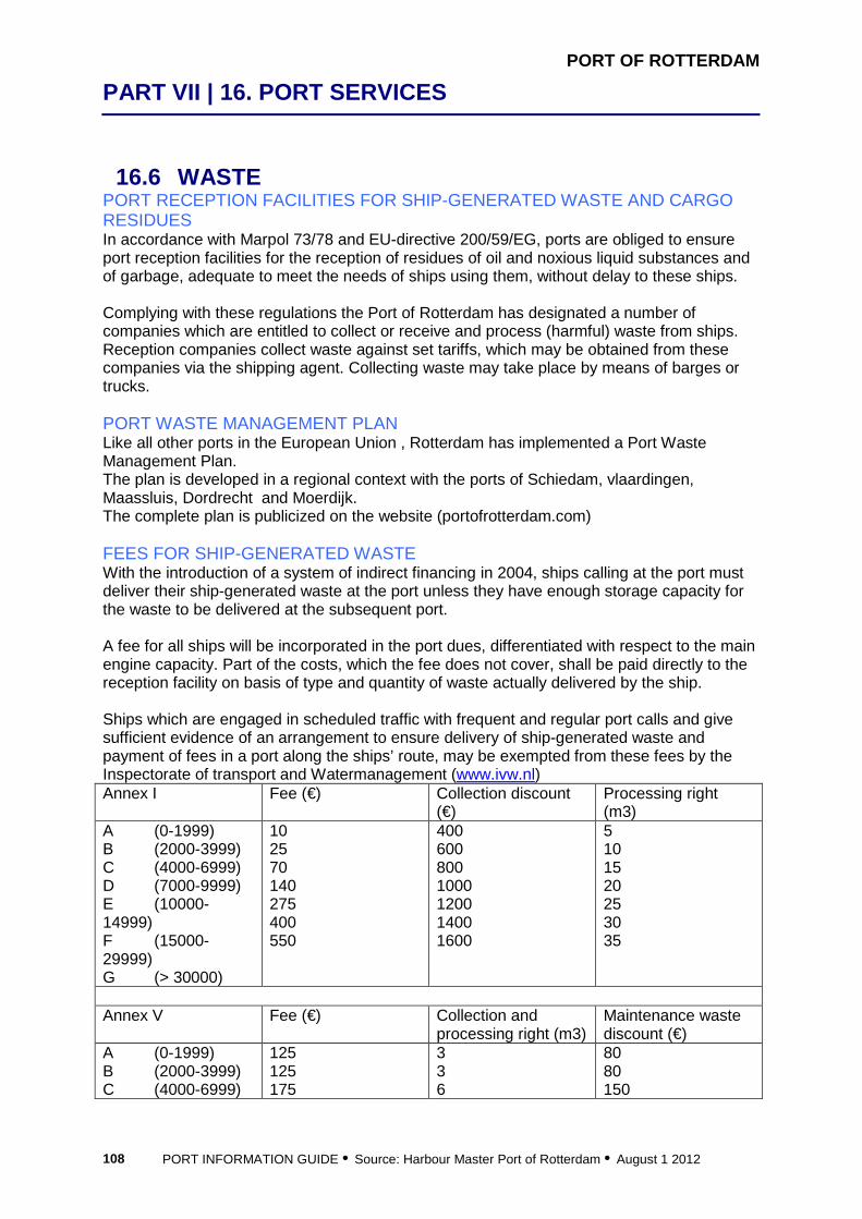
PORT OF ROTTERDAM
PART VII | 16. PORT SERVICES
PORT INFORMATION GUIDE • Source: Harbour Master Port of Rotterdam • August 1 2012 108
16.6 WASTE PORT RECEPTION FACILITIES FOR SHIP-GENERATED WASTE AND CARGO RESIDUES In accordance with Marpol 73/78 and EU-directive 200/59/EG, ports are obliged to ensure port reception facilities for the reception of residues of oil and noxious liquid substances and of garbage, adequate to meet the needs of ships using them, without delay to these ships. Complying with these regulations the Port of Rotterdam has designated a number of companies which are entitled to collect or receive and process (harmful) waste from ships. Reception companies collect waste against set tariffs, which may be obtained from these companies via the shipping agent. Collecting waste may take place by means of barges or trucks. PORT WASTE MANAGEMENT PLAN Like all other ports in the European Union , Rotterdam has implemented a Port Waste Management Plan. The plan is developed in a regional context with the ports of Schiedam, vlaardingen, Maassluis, Dordrecht and Moerdijk. The complete plan is publicized on the website (portofrotterdam.com) FEES FOR SHIP-GENERATED WASTE With the introduction of a system of indirect financing in 2004, ships calling at the port must deliver their ship-generated waste at the port unless they have enough storage capacity for the waste to be delivered at the subsequent port. A fee for all ships will be incorporated in the port dues, differentiated with respect to the main engine capacity. Part of the costs, which the fee does not cover, shall be paid directly to the reception facility on basis of type and quantity of waste actually delivered by the ship. Ships which are engaged in scheduled traffic with frequent and regular port calls and give sufficient evidence of an arrangement to ensure delivery of ship-generated waste and payment of fees in a port along the ships’ route, may be exempted from these fees by the Inspectorate of transport and Watermanagement (www.ivw.nl) Annex I Fee (€) Collection discount
(€) Processing right (m3)
A (0-1999) B (2000-3999) C (4000-6999) D (7000-9999) E (10000-14999) F (15000-29999) G (> 30000)
10 25 70 140 275 400 550
400 600 800 1000 1200 1400 1600
5 10 15 20 25 30 35
Annex V Fee (€) Collection and
processing right (m3) Maintenance waste discount (€)
A (0-1999) B (2000-3999) C (4000-6999)
125 125 175
3 3 6
80 80 150

PORT OF ROTTERDAM
PART VII | 16. PORT SERVICES
PORT INFORMATION GUIDE • Source: Harbour Master Port of Rotterdam • August 1 2012 109
D (7000-9999) E (10000-14999) F (15000-29999) G (> 30000)
175 175 175 175
6 6 6 6
150 150 150 150
Reporting delivery 1. The captain of a sea-going ship carrying on board ship-generated waste and other noxious substances or residues of noxious substances, shall ensure that his intention to deliver those substances is reported to the harbour master, at least 24 hours prior to the commencement of the delivery. (see chapter 4.9) 2. When reporting, it shall be communicated simultaneously to which designated company the delivery will be made, which noxious substance will be delivered and the quantity thereof.
16.7 REPAIRS More information on repair companies can be found on www.rotterdamportinfo.com/results.cfm?sbranch=ShiBui
16.8 DE-RATTING Ship Sanitation Certificates (former De-ratting certificates) Applications for Ship Sanitation Certificate inspections can be submitted to the GGD. The GGD is responsible for issuing Ship Sanitation Certificates in the port of Rotterdam. To apply for a Ship Sanitation Certificate please visit www.portofrotterdam.com/en/Shipping/rules-regulations/port-health-authority/Pages/ship-sanitation-certificates.aspx
16.9 SURVEYORS More information on surveyors can be found on www.rotterdamportinfo.com/
16.10 SHIPPING AGENTS More information on shipping agents can be found on www.rotterdamportinfo.com/ Shipping agents are not compulsory. However, prior to the electronic statement as mentioned in Chapter 4.5 (sending ETA), the client must provide security in the form of a security deposit or bank guarantee. Normally this is done via the ship agent. If one has no ship agent, one might consider the services of Dirkzwager (www.dirkzwager.com)

PORT OF ROTTERDAM
PART VII | 16. PORT SERVICES
PORT INFORMATION GUIDE • Source: Harbour Master Port of Rotterdam • August 1 2012 110
16.11 MEDICAL FACILITIES Special arrangements for the accommodation of seamen The Port Hospital is unique in the Netherlands. It is the first port hospital with special arrangements for the accommodation of seamen of all ranks and nationalities. Clinical observation and treatment as well as the outpatients department can rely on almost all forms of medical specialist care provided by foremost practitioners in their field. The staff speaks many foreign languages and the hospital is the only one in Rotterdam to have specialists in tropical medicine on the staff. Havenziekenhuis (Port Hospital) Haringvliet 2 3011 TD ROTTERDAM Telephone: +31 10 404 33 00 More hospitals and information can be found on www.portofrotterdam.com/en/Shipping/rules-regulations/port-health-authority/Pages/medical-facilities.aspx
16.12 SEAMAN'S MISSIONS The port of Rotterdam has extensive facilities for crew members. These services include medical facilities as well as recreation and travel services. SEAMAN’S STORES There are two seaman’s stores in the port of Rotterdam. Transport is provided free. Opening times: Monday – Friday 10.00 – 21.00, Saturday 10.00 – 18.00, occasionally Sunday 09.00 – 12.00. Store at berth number 4053, 3rd Petroleumhaven Store at berth number 6220, Dintelhaven Consult the Port numbers & route on www.portofrotterdam.com.
16.13 TRANSPORT Rotterdam Airport (distance - 6 kilometers from downtown Rotterdam) Rotterdam Airportplein 60 3045 AP ROTTERDAM Telephone: + 31 10 446 34 44 www.rotterdam-airport.nl Amsterdam airport Schiphol (distance - 70 km from downtown Rotterdam) Evert v/d Beekstraat 202 1118 ZG SCHIPHOL Telephone: 0900-schiphol or 0900-72447-465 (calling from the Netherlands) Telephone: +31 20 794 08 00 (calling from abroad)