Embed Size (px)
Citation preview

Pilgrim’s GuideThe Mozarab Way of Santiago

Published by: CEDER “La Serena”© Of the texts and images: Associations of Friends of the Mozarab Way of Almeria, Badajoz, Cordoba, Malaga, Granada and Jaen together with the Groups of Rural Development as associate members of the cooperation project: Alpujarra Sierra Nevada (Almeria), PROMOVEGA and Poniente Granadino (Granada), ADSUR (Jaen), Valle del Guadalohorce, NORORMA and Region on Antequera (Malaga), Subbetica, ADEGUA, Sierra Morena and Los Pedroches (Cordoba) and ADECOM-Lacara, ADEVAG and La Serena (Badajoz).Financed by: Ministry of Agriculture, Food Quality and Environment. The National Rural Network.Legal Deposit: BA-661-2013ISBN: 978-84-95635-16-7www.caminomozarabedesantiago.es
No part of the content of this Guide may be reproduced.
Traslation: Elvira López Rodríguez y Juan Carlos Palacios RastrolloDesigned by: Zumaya Ambiente Creativo.First edition: 3.000 copies

3
INDEXEveryone’s Guide ................................................The Mozarab Way of Santiago..................Understanding this guide.................................Suggestions and comments..........................Legend..............................................................The Way of Almeria...........................................The Way of Granada ........................................The Way of Jaen ................................................The Way of Malaga ..........................................The Way of Cordoba ........................................From Merida to Santiago de Compostela .........
469
11131424
1088246
114

4
This Guide of the Mozarab Way of Santiago implies a great effort in an attempt to gather in an only book some Ways which in their search for Santiago de Compostela depart from the Western provinces of Andalucia. Cities like Alme-ria, Malaga, Granada and Jaen get linked up in an only path to converge in Cordoba.
From that point, the Pilgrim will step into the lands of Extre-madura through the Badajoz district of La Serena, following through the Vegas Altas del Guadiana till he gets to Merida. At this point the Southern Mozarab Ways coming from Se-villa, Huelva and Cadiz will get linked up. From here, all of them will share the millennial Via de la Plata.
The Way joins its historial background with an enormous cultural and faith experience. Its route has been revitalised by the Jabobean Associations since the beginning of the
decade of the 90s of the previous century. In 2010 The Mi-nistry of Agriculture passed the Interterritorial Project of Cooperation which, coordinated by the CEDER La Serena (Badajoz), includes fourteen Groups of Local Action - eleven from Andalucia together with three from Extremadura. One of the main goals of the Project has been the creation of an innovative pattern of planning and management of the Mo-zarab Way of Santiago as an European Cultural Itinerary, according to the needs and motivations of the Pilgrim of the XXI century. To develop the Project successfully, some general objectives have been taken into account by the associate members such as:
• The consolidation of a cooperation network among Groups of Local Action of Extremadura and Andalucia, affecting the stimulation of the territories along which the Way goes.
EVERYONE’S GUIDE

5
• The stimulation of the Local Administrations, provincial and local Associations, social and economic fabric around a project of rural development.
• The creation of new opportunities for the affected rural areas and the diversification of the economic rural activity.
In order to get those objectives within the Project and during the last four years, the Local Action Groups together with the Associations of Friends of the Mozarab Way have been cooperating and have created collaborative networks. This way they have reinforced the cooperation between Groups and have found support in the different social and economic agents of the territories and have also invited the citizens to be participative at all times.
Thanks to these efforts there have been carried out lots of activities and of widespread actions which have helped to consolidate in each of those territories a Way which is not only full of History but also full of present. The awareness-raising task on the population through which the Way goes is crucial to get a Way for everybody. Indeed, these people make the pilgrims feel visible and well-hosted.

6
The well-known Mozarab Way was used by the Chris-tians who lived in the Arabic kingdoms to get connected to the Via de la Plata until Santiago de Compostela. Being this route one of the oldest ones belonging to the Way of Santiago.
The Muslim domination started at the beginning of the VIII century over the best part the peninsular territory would end influencing the religious life of the inhabitants of the old Visigothic-Christian kingdom. Thus, once the news of the discovery of the Apostle Santiago’s sepulchre in Galicia was spread, the Christians who lived in the territories under the Muslim domination would try to go on a pilgrimage to Compostela. These Christians received the name of Mo-zarabs and got to carry on with their faith and consolidate their own religous culture.
During the intermittent periods of peace between the Christian North and the Muslim South the pilgrimage to Santiago’s sepulchre in Galicia was being forged. The itinerary followed from the Al-Andalus territories, current Andalucia, used the communication routes established by the Romans. The Mozarabs coming from Almeria, Gra-nada, Malaga or Jaen merged into the former Cordoba to continue from there to Merida through the main route of communication.
The proposed itineraries in this guide are the result of years of experience of the Associations of Friends of the Way of Santiago and the perseverance and effort, lately, of the Groups of Rural Development, the involved Public Adminis-trations, the private firms which complement the hostage network and the local population of all these villages
UNDERSTANDING THIS GUIDE. The Mozarab Way of Santiago

7
through which the Way runs. The paths respond to two criteria:
1.- Historical. These paths go along Roman roads, Medieval paths and livestock trails with a great transversal axis which departs from Almeria, gets to Granada continues towards Cordoba and from here gets linked in Merida to the well-known Via de la Plata. Other two Ways merge into this axis: the Way of Malaga which does so at the village of Baena and the Way of Jaen, at Alcaudete.
2.- Practical. There is no doubt that the passing of the years and the different historical circumnstances or the creation of new infraestructures in the territory require to adjust these ways to the new necessities. For this reason, some itineraries are proposed, which committed to the first abovementioned criterion, to make it possible to do the Way in safe conditions, providing the pilgrims with infraestructures for their rest and provisions.

The
Mozarab
Way
of
Santiago

9
As we have already explained before, this Pilgrim’s Guide includes several Ways which depart from Al-meria, Granada, Jaen, Malaga and Cordoba and which merge into Merida to continue through the Via de la Plata of Santiago de Compostela. To make its reading easier, it has been divided into different parts which appear perfectly distinguised by colours and which correspond to each of the provinces through which the Way runs.
If you start the Way in Almeria, you will do a thorough reading of the guide until you get to Merida.If you start the Way in Granada, you will begin reading from page 24 onwards.If you start the Way in Cordoba, you will do so from page 46 onwards.If you start the Way in Jaen, you will begin reading from page 110 onwards. When you get to the town of Alcaudete, you will turn back to page 44. From here on you will keep on reading thoroughly until you get to Merida.If you start the Way in Malaga, you will do so from page 84 onwards. When you get to the town of Baena, you will turn back to page 50. From here on you will keep on reading thoroughly until you get to Merida.
UNDERSTANDING THIS GUIDE

10
From Merida you will go on along the Via de la Plata passing by the cities of Caceres, Plasencia, Salamanca, Zamora and Orense, among others, until you get to Santiago de Compostela. At the end of the guide you will find a chart with all the places through where you will pass and the distances in kilometres among them. If you want to get information about this last stretch, we recommend you to visit the following web sites:
www.caminomozarabedesantiago.es www.viaplata.org
You can also download the following app for mobile devices: CMsantiago

11
The experience of other pilgrims who have done the Way before you and that of the Associations of Friends of the Way of Santiago let us recommend you:
1 The pilgrimage is a mainly religious act. The art, the landscape of the Way and the values closely related to the pilgrimage (self-improvement, solidarity, etc.) contribute to highlight this dimension.
2The most appropriate seasons of the year to make the pilgrimage are in spring and autumn. If it’s made in summer, you must take into account the high temperatures which can be reached, overpassing the 40º C many days. In these cases it’s recommended to start the stage with the first light
of the day (never at night!) and to rest in the afternoon to continue walking in the evening. A straw hat is the most convenient for this situation.
3 Both in Andalucia and Extremadura the villages are frequently very distant one from the other and it’s pretty normal to do 20 kilometres or more without finding any spot of provisions. Moreover, there are few fountains at the dispossal of the pilgrim. Therefore, before you start the Way it’s advisable for you to get provided with some food and at least 1 litre of water (this quantity should be increased in summer).
4 The division in stages which has been made in this guide is merely orientative. Our intention is not to force anyone to
SUGGESTIONS AND COMMENTS
12
do more tan 40 kilometres a day and also to let them finish the stage at villages where they could find either a hostage or at least a place to stay. Moreover, we have to bear in mind that the Way can be done on foot, by bike, by horse, etc. and, so, some stages can be easier than others.
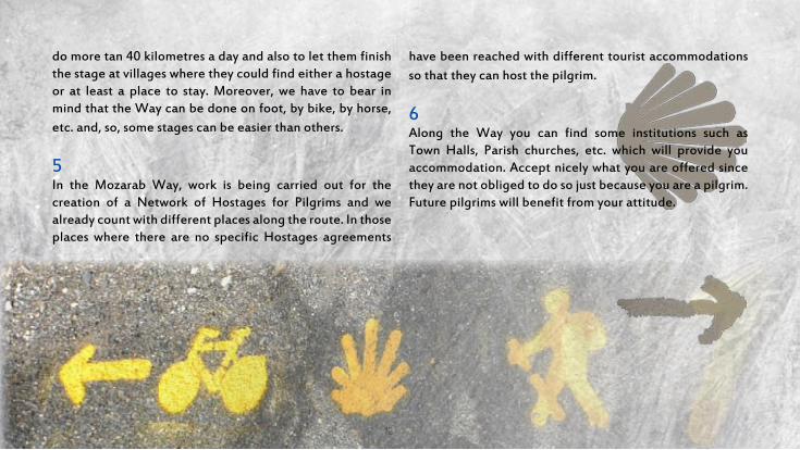
5 In the Mozarab Way, work is being carried out for the creation of a Network of Hostages for Pilgrims and we already count with different places along the route. In those places where there are no specific Hostages agreements
have been reached with different tourist accommodations so that they can host the pilgrim.
6 Along the Way you can find some institutions such as Town Halls, Parish churches, etc. which will provide you accommodation. Accept nicely what you are offered since they are not obliged to do so just because you are a pilgrim. Future pilgrims will benefit from your attitude.

LEGEND
Hostel
Special tree
Town Hall
Campsite
Castle
Cross
Dolmen
Special building
Bus station
Train station
Fountain
Information Point
Museum
World Heritage
Bridge
Emergencies
Archeological areaChurch


Pilgrim’s Guide The Mozarab Way of Santiago15
ALMERIA, the Roman Portus Magnus, became the Mariyat Bayyana (Bayana’s watchtower) along the centuries, in the same place where the anchorage and the watchtover of the Muslim city with the same name were located. That watchtower was placed a few kilometres further up the Andarax River, in the surroundings of the present villages of El Chuche and Pechina.
As the years pass, Bayyana starts falling into decay while the importance of Al-Mariyat increases. In 955 Abderrahman III orders to wall the city in and to build its citadel and its main Mosque. From that moment, the former small settlement becomes a medina, the definitive city of Almeria was born and was incorporated within the Crown of Castilla in 1489.
We can go for pleasant walks along the recently pedestrianized streets within the historical city centre. Thus, we can get in contact with the neighbourhoods which are heirs to that past and to their main patrimonial vestiges, like the Citadel, San Juan Church, the fortress-Cathedral, The Plaza Vieja or the “Cable Inglés” (a mineral loading platform), together with some other elements of interests.
Once the Way has started, our itinerary runs along the succession of the valleys of the rivers Andarax and Nacimiento to head towards Gua-dix and Granada following the former Roman and Muslim Ways.
This Way from Cathedral to Cathedral shows that they were built under the same political, social and religious feeling, though with different architectural styles (since the situations and needs of both Almeria and Santiago, at the time these cathedrals were built, were different as well). In this sense, going over the major diagonal of the Iberian Peninsula gives even more interest to this Mozarab Way of Santiago.
There is no doubt that this cultural itinerary, apart from everyone’s religious beliefs, will help us find the deepest essence within ourselves, alone or in company of our closest ones, to equally get in contact with a countless number of people from the villages and from the “Cami-no”, which, definitely, will help us overcome our challenge.
The Way of Almeria.Province of Almeria

We depart from the Cathedral, located in the old quarter of the city, and following the Way of Granada, to get to Huercal de Almeria. We will leave the urban framework aside and we will enter Pechina through the Andarax River. Passig by the Bayyana’s ruins we will go back to the river and we will get to Rioja. Through the Historical Way of Quiciliana, in Paulenca, History and Heritage will accompany us till we arrive at Santa Fe de Mondujar.
To Santiago:1.395 km
Almeria - Santa Fe de Mondujar

Pilgrim’s Guide The Mozarab Way of Santiago17
We start the Way in the very core of the his-torical city centre at the foot of the Citadel and in front of the Big Gate of the Fortress-Cathedral. Behind we are leaving streets and squares full of joy and colour: Lope de Vega, Las Tiendas Street, Santiago’s Church, Puerta Purchena, Murcia Street, Rambla Amatisteros, Carretera de Granada until the arrow-monolite of Torrecardenas’ roundabout farewells us.
Always heading forwards we enter Huer-cal in Almeria until we reach the railway station which reminds us of the splendour of the village mining past. We walk along Real Street until we get to the Camino Real of Pechina which will lead us to the Andarax River. Once in the River, La Ram-bla of Pechina shows us the way towards this important spot, origin of civilizations like Bayyana. After getting around the city centre we go down to the river again and
when we leave the Puente de Rioja behind, the Camino del Duende will lead us into the village of Rioja.
Among orchards and country houses the Way goes straight on the Vereda of Quici-liana until we get to Santa Fe of Mondujar, and we are pleased to know that our steps get melted over what is a Way full of History and patrimonial vestiges.
Almeria - Santa Fe de Mondujar (25 km)Relevant information
AccommodationPilgrim’s info MuseumsHeritageRestaurantsHealth CentrePublic transportPolice Station
Huérc
al de
Alm
eria
Almeri
aPe
china
Rioja
Paule
nca (
Gador)
Santa
Fé d
e Mon
dujar
Almeria Andarax River

The Nazari Tower of Santa Fe starts the ascent which will lead us into the Sierra de los Filabres. The paved way ends in the watercourse of Gergal and after that we will have 5 km of narrow paths and strong ascents, of awesome landscapes and stunning views of the Alpujarra Almeriense. On our descent, we are welcomed by the Natural Park of Sierra Nevada and the so called “pueblos blancos” (white villages), which remind us of the Muslim past of our Way: Alhabia, Alsodux, Santa Cruz de Marcherna and Alboloduy.
To Santiago:1.379 km
Santa Fe de Mondujar - Alboloduy

Pilgrim’s Guide The Mozarab Way of Santiago19
We start this stage at the foot of the Nazari Tower of Santa Fe of Mondujar and we have to ascend towards the impressive railway line iron bridge attributed to Gustavo Eiffel.
Once we culminate the summit, several yellow arrows and scallop shells will lead us to the very core of the Sierra of the Fila-bres. Friendly arrows which will guide our way among pine groves, broom and “albaidas” on our search for Alhabia: a white “alpujarreña” village which links the Way with a timid river and orange tree meadows.
The “Alpujarreño” and Mozarab Way where the terraced landscape, the toponyms and the irrigation system which remind us of the important mark of the Muslim colonization over the region, will go on upstream of the main Andarax River affluent: the Nacimiento, which delimits the east and north of the Sie-rra Nevada impressive massif.
The watercourses which bleed into ditches will lead us towards the oasis formed by the irrigated meadows which cross the “almerien-se” subdeserts, generating this way a unique landscape full of contrasts.
On our way we will cross the villages of Alha-bia, Alsodux, Santa Cruz de Marchena and Alboloduy. This last village which marks the end of the stage and is one of the richest ones within the Region concerning its Histori-cal Heritage, is also provided with an inviting hostel for pilgrims.
Santa Fe de Mondujar - Albolduy (15 km)Relevant information
AccommodationPilgrim’s info MuseumsHeritageRestaurantsHealth CentrePublic transportPolice Station
Alha
bia
Santa
Fe d
e Mon
dujar
Also
dux
S. C
ruz de
Marc
hena
Albo
loduy
Santa Fe to Alhabia stretch
Alhabia

Alboloduy looks like a Christmas postcard from the very entrance of the Way into this place. After walking through its streets, we look for the river again and after a steep ascent we will share a stretch of the road till the Aljibe Bermejo where a dirty path leads us again to Nacimiento. The watercourses which bleed into ditches will lead us towards the oasis formed by the irrigated meadows which cross the “almeriense” subdeserts, generating this way a unique landscape full of contrasts when you pass by Nacimiento, Los Gregoros, Doña Maria, Ocaña, Las Juntas and Abla.
To Santiago:1.352 km

Pilgrim’s Guide The Mozarab Way of Santiago21
Leaving Alboloduy, we will go upstream for 2,7 km until we reach an area where we can’t follow the river’s course because of the heavy vegetation all around. We will take a steep path going up the half hillside on our right to get to the road which we will follow with the help of the signs all the way to the Llano del Campillo. Some metres behind the Water Cistern (“Aljibe”), we will take the path on the right which will lead us again to the river. Then, we will arrive at the village of Na-cimiento through a natural reed tunnel of the Sierra Nevada Natural Park.
From now on, the riverbed of the watercourse will be again the base of our way, already inside the medium-high track of the valley. Sierra Nevada will form the south hillside and Los Filabres Mountain will be the north wall along our way. Threshing floors, mills, olive oil mills, irrigation infrastructures, slate country houses and mine quarries are scattered along these urban areas: La Rambla Encira,
Los Gregorios, Doña Maria and Ocaña, which will remind us of the mining and agricultural past taste from other times.
Following the river, in its meeting point with the Rambla de Abrucena we will find “Las Juntas”. We will cross the river lengthways through the local road until we cross the former National one. Then, we will descend the watercourse of Abrucena and will go upstream until we arrive at Abla.
Albolduy - Abla (27 km)Relevant information
AccommodationPilgrim’s info MuseumsHeritageRestaurantsHealth CentrePublic transportPolice Station
Nacim
iento
Albo
loduy
Los G
regori
os
Doña
Mari
aOca
ñaLa
s Jun
tasAb
la
Alboloduy Nacimiento River

The age-long Abla, at the foot of Sierra Nevada, will lead us, after an urban route, to El Camino Real, a historical way between Granada and Almeria. For centuries, this Camino Real was used by people, troops, merchandise, etc. and there numerous services for muleteers and the cavalry were established thanks to that via. Again through the watercourse of the river, we get to the monumental Fiñana. Threshing floors, mills, olive oil mills, country houses and taverns are scattered along the Way which leads us to Venta Ratonera and Hueneja, in Granada.
Hueneja
To Santiago:1.326 km

Pilgrim’s Guide The Mozarab Way of Santiago23
Abla, one of the villages where the different prehistorical and historical periods are best represented by its archeological stages, hosts the pilgrim in the Roman Mausoleum. Along a simple walk through the urban network, the route, from El Paseo, offers a gorgeous overview of Sierra Nevada and the close village of Abrucena.
We go on through the path which crosses the Nacimiento River to get to the Camino Real, a former communication via which, for centuries, was used by the people, troops, merchandise, etc. that circulated between Granada and Almeria. Numerous service and sale points for muleteers and the cavalry were established thanks to that via.
We will return to the river and will go upstream again until getting to the village of Fiñana where, in 1489, the Catholic King and Queen passed the night in its Fortress-Castle on their way to conquer the kingdom of Granada. It’s
also worth mentioning Fiñana’s Water Cistern (“Aljibe”) and its Almohad Mosque.
Walking up Real Street, at the church’s square, we turn right and look for the descent towards the Rambla de Almeria to continue through the abovementioned historical path, which will lead us to Venta Ratonera.
Leaving this village behind, we cross a watercourse and an arrow-shaped monolith will farewell the pilgrim out of the province of Almeria. This same monolith will show the way to be followed straight on towards the Huertezuelas, already located in the province of Granada.
Abla - Hueneja (26 km)Relevant information
AccommodationPilgrim’s info MuseumsHeritageRestaurantsHealth CentrePublic transportPolice Station
Camino
Rea
l (Abru
cena
)
Abla
Fiñan
aVe
nta R
atone
ra
Las H
uerte
zuela
s
Huen
eja
Fiñana Border with the province of Granada


Pilgrim’s Guide The Mozarab Way of Santiago25
The itinerary, after leaving the neighbouring Almeria behind, runs between the high mountain of Sierra Nevada and the arid areas of the so called “bad-lands” found in the depression of Guadix until it finishes at the ancient Granada. We will arrive in Granada leaving behind the greenery of Sierra de Huetor. This Way, which has been occupied by men since the most ancient Prehistory, preserves a cultural heritage largely diverse together with a wide range of services.
The Way of Granada.Province of Granada

We enter the province of Granada from Las Huertezuelas and a few kilometres ahead we get to Hueneja where we can start seeing the contrast of arid landscapes surrounded by high mountain areas. We will follow towards Dolar and Ferreira where the Medieval and Moorish ruins get mixed up with the mining ones. At the foot of a limestone promontory, the Castle of La Calahorra welcomes us, a place to be visited and also to rest at and to recover our strength before we retake the Way which will lead us to the mining and astonishing Alquife.
To Santiago:1.305 km

Pilgrim’s Guide The Mozarab Way of Santiago27
We head towards Dolar passing over the road bridge and next to the Shrine of La Presentacion. When we get to the threshing floors, we will turn right among them to continue in parallel to the road. Without reaching the motorway, a small road, which passes over the petrol station, will lead us to a wire fence from whose gate the path heading towards Dolar starts. Dolar is a village with a simple castle, an outstanding church and interesting Arabic baths.
From the top we can see the extreme change in the function of the impressive flat field of the “Marquesado” del Zenete (the former bottom of the intramountainous lake generated during the Alpine fold and drained by the opening of the rivers Fardes and Guadiana Menor). That plain was first a grain larder to become later a power station due to its eolic fields, its photovoltaic and thermosolar power plants.
From the Shrine of San Andres we take the road on the right after a detour. That road goes straight
on towards the west until the village of Ferreira where we can find the Interpretation Centre of the Arabic Architecture within the Fortress-Castle. On our way towards La Calahorra we will cross the road of Puerto de La Ragua and then we will follow a track which will lead us to this village with an incomparable Renaissance castle.
The straight-line road will lead us to Alquife, a village of a strong mining past where the largest open-pit mine of Andalucia is located. The iron mineral was taken out through its own Linares-Almeria railway branch line to that last city, Al-meria. After a near shut down of this mine in the 90s, today a reopening is being worked out due to the mineral price increase.
Hueneja – Alquife (21 km)Relevant information
AccommodationPilgrim’s info MuseumsHeritageRestaurantsHealth CentrePublic transportPolice Station
Dolar
Huen
ejaFe
rreira
La C
alaho
rra
Alqu
ife
La Calahorra Dolar

The history of Alquife is, undoubtedly, the history of the mining industry. Until the end of the XX century the most important open-pit iron mines in Spain were in operation there. This activity left a stunning mining landscape behind. After a light ascent through Sierra Nevada we get to Jerez del “Marquesado”, which was the most important village of the Sened for a long time, becoming later on “Marquesado” del Cenete. At the foot of Sierra Nevada we reach Cogollos de Guadix, a small village with a gorgeous landscape and an astonis-hing Mudejar Church which competes in beauty with the cathedral of Guadix, located at eleven km further.
To Santiago:1.283 km

Pilgrim’s Guide The Mozarab Way of Santiago29
Leaving towards Jerez we can see the mass of the Picon de Jerez, the most oriental “3000 me-tres” of Sierra Nevada. At 1 km the road goes over the bridge of the Lanteira’s watercourse. Soon after passing it, the path, which after crossing the Guadix River leads us towards Je-rez del “Marquesado”, comes out first on the right and immediately after on the left.
We will take the Guadix road at 2,5 km. Then, on the left, we will find the small road which heads towards Cogollos de Guadix, where its Medie-val water cistern (“aljibe”) is worth mentioning. We will leave the village through San Grego-rio Street towards the Shrine under the same name leaving it behind to our left.
If we continue straight on, at about 2 km, the road goes down until we leave the vast “Marque-sado” and the second most typical landscape of the Guadix region opens up in front of us: the “bad-land” gullies generated by the progressive dismantling of the former lake’s bottom. When
we get to the watercourse, we will descend along it for 200 m to take another road which follows the descent towards Guadix.
We enter Guadix through Torremolinos Street leaving to our left one of the most typical brickworks which using the “bad-lands” clays have developed the ancestral pottery industry of the region. If we go straight on, we will cross one of the traditional cave neighbourhoods and we will pass next to their Interpretation Centre. Going down Cañada de los Perales and Carrera de las Cruces Streets, we will overflow the “Al-cazaba” on the right until we get to Santiago’s Church. Finally, An-cha and Pedro An-tonio de Alarcon Streets will lead us to the Cathe-dral.
Alquife – Guadix (22 km)Relevant information
AccommodationPilgrim’s info MuseumsHeritageRestaurantsHealth CentrePublic transportPolice Station
Jerez
del M
arque
sado
Alqu
ifeCo
gollo
s de G
uadix
Guadix
Picon de Jerez Guadix Cathedral

Guadix is the most important municipality of the District and apart from having a stunning monumental heritage, it is the administrative and economic capital and where most of the public and private services are lo-cated. After a circular route around Guadix, we will continue towards the small village of Paulenca and along a dirt path. Going always straight on we will step into the environmental landscape of Marchal where the so-called “bad-lands” of strong reddish tones contrast with the green meadow and Sierra Nevada, declared as Natural Monument. La Peza was a crucial spot in the Muslim time in the Way of Guadix to Granada, being a proof of that the remains of its castle and a very well preserved urban centre of Moorish origin.
To Santiago:1.263 km

Pilgrim’s Guide The Mozarab Way of Santiago31
We leave Guadix through Granada and Caña-veral Streets and Paulenca’s road. Paulenca is a small village towards which we head. When we get to it, we will border the village towards the west, 40 metres after we reach a small triangular roundabout with a tiny tree. From this point, on the left, we will take a descending track which will let us go up the hill towards Mar-chal. When we get to a U-shaped crossroads, we will turn right to get access again to the plains of the former lake bottom. Inmediately after, on the right, we will take a track which will lead us in descent along the riverbed of the leafy watercourse of Zamar.
When we get to the Alhama River we will descend along it for about 200m to get to Mar-chal crossing the road. The gorgeous gullies of Marchal have been declared Natural Monument for being emblematic of this landscape. After crossing Marchal, we will get to the watercourse of Alboroz, (which surrounds it from the south), and we will go up this watercourse along 1.300
metres until reaching the small watercourse of La Cañada del Carril. Going up along this small watercourse (only at 450 m far from the watercourse of Alboroz) we find an ascending path, obliquely to the right, which will lead us to the small road of La Peza and we will take it on the left.
A longer but less rough alternative consists of leaving Marchal through the north following the riverside of the gullies until getting to Los Baños de Graena. In both cases, we will follow the historical road of La Peza, without taking the crossroads on the right which follows a route with much more tra-ffic and less attrac-tive.Finally, we will get to a viewpoint from which we will be able to percei-ve, at a bird’s-eye view, our destiny.
Guadix - La Peza (20 km)Relevant information
AccommodationPilgrim’s info MuseumsHeritageRestaurantsHealth CentrePublic transportPolice Station
Paule
nca
Guadix
Marcha
lLa
Pez
a
La Peza’s former road
Marchal

The pressence of water will be a constant and will give the mark to the landscape which has accom-panied us since we left La Peza till we enter the picturesque village of Tocon de Quentar. A dirt path leads us to the depression of the Aguas Blancas River and which splits Sierra Nevada from the Sierra de Huetor. We will leave the Quentar’s dam behind and it will announce the proximity of the village under the same name.
Quentar
To Santiago:1.240 km

Pilgrim’s Guide The Mozarab Way of Santiago33
Passing by the church and behind Los Caños Gordos Fountain, we will climb up the castle. Soon after passing it, the track towards Quen-tar comes out to the right. When it snows, only the pilgrims with mountain experience and well-equipped will be able to use this option. A lower alternative comes out just before we get to the castle, heading west, until getting to Quentar Road.
Along the high track, at 2,5 km, we will get to a cross-shaped crossroads and we will take it on the right to go down the road. Through the road shoulder, we will cross La Gitana’s Gorge with its typical tumbledown dolomites. Inmediately after and parallel to the road it appears a small path which, about 300 m after passing Los Blancares’ Hillock, will get separated from that road to reach Tocon de Quentar. With snow, the ones with no experience must use the road to get to Quentar. In winter, you mustn’t leave To-con after two o’clock in the afternoon.
Following the road, at only 0,5 km, it comes out on the right, through the bare hill, a small track which goes up the path we will take on the left. We will go straight on for 4 km until we get to Puerto Blanco, a crossroads we will take on the left to get to the great abandoned quarry of La Unica. If it gets dark, we can use its abandoned huts as a shelter. From the southern opposite side of the quarry, in descend, it comes out the path which will lead us to La Plata country house. From here, we will descend 2 more kilo-metres until we get to a deviation on the right (where an enourmous cattle large yard is loca-ted) which will lead us to Quentar.
La Peza – Quentar (23 km)Relevant information
AccommodationPilgrim’s info MuseumsHeritageRestaurantsHealth CentrePublic transportPolice Station
Toco
n de Q
uenta
r
La P
eza
Quenta
r
La Gitana’s Gorge
La Venta’s Watercourse

After crossing the village of Quentar, we take again the dirt path which leads us to Dudar. We will go straight on and will continue our way through the Llano de la Perdiz. At this point, the impressive view of the Alhambra’s hill with the Nazari city at its feet eliminates the accumulated tiredness of the 200 km walked since we left Almeria. We will arrive in Granada through the Alhambra’s Gate.
Quentar
To Santiago:1.220 km

Pilgrim’s Guide The Mozarab Way of Santiago35
From the Square of Quentar we will go down the river to take the track which will lead us to the road we will follow until Dudar. From the low opposite side of the village a path to the right comes out and, in ascent, will pass by the exit of the impressive siphon of Los Franceses Channel. A titanic work accomplished at the end of the XIX century by ingeneers of that nationality to carry water to the gold mining of the Darro River.
Close to the highest part of the long slope a track comes out to the right. This track which has got a gate (with right of way) goes down until the Belen River. When we pass the Belen country house the road crosses again the river to go back to the track over the hillock. Once we get to this track, after half a km, we will get to a crossroads. Crossing Los Franceses Channel’s threshold on the right, we will immediately go up a path on the left which will lead us to the Dehesa del Ge-neralife. We will go along the north border of the Llano with an overview of the Darro River until
we see the Sacromonte neighbourhood and its abbey at the bottom of the valley.
In our descent, we will pass next to the “Aljibe de la Lluvia” and after crossing its plateau, we will go along the edge of the highlands until our arri-val at the Silla del Moro, fortress which used to protect the access to The Alhambra. From there we will go down till The Alhambra’s entrance.
We propose to go down to Granada through the slope of the “Chinos” which starts at The Mim-bre restaurant, between the Alhambra and The Generalife, to get to the “Pa-seo de los Tristes”. From here the spectacular Carrera del Darro will lead us to the Plaza Nueva.
Quentar – Granada (20 km)Relevant information
AccommodationPilgrim’s info MuseumsHeritageRestaurantsHealth CentrePublic transportPolice Station
Duda
r
Quenta
rGran
ada
Sacramonte’s Abbey
Los Franceses Channel

Leaving Granada behind, Maracena will emerge for the traveller almost inside its urban framework. After Atarfe, and following the Camino Real, the plain of La Vega of Granada aligns with the presence of Sierra Elvira. Going around this important elevation, the pilgrim will reach Pinos Puente circumvating the Cubillas River thanks to its emblematic Bridge of La Virgen de las An-gustias, over which he will enter the town.
To Santiago:1.177 km

Pilgrim’s Guide The Mozarab Way of Santiago37
We leave Granada after passing the Plaza de Europa roundabout on the right and following the arrows. To the third exit we will find a park next to the railway line. At the end of this park we get to an aerial pass over the railway line and after going down through it, we will turn right towards Maracena. We arrive at Cerrillo de Ma-racena continuing along the road which runs in front of the park, through which we have come, and already leaving Maracena behind; then, we will keep on walking along this road pavement for about 500 m and we will continue through a dirt path during other 1.100 m, going back to the paved road and passing behind “La Higueruela” Park we will get to Atarfe.
We will go around the park on the left and we will come across a roundabout and the monument to La Libertad. We will look for Alfonso Bailon Street to gain access to the Town Hall Square. We will continue on the left through Real Street which will get linked up with La Estacion Avenue where we will find a roundabout. At this point, we will deviate to the right, taking Aragon Street.
At the outskirts there is another roundabout and a bullring. Under the A-92 road we will follow a paved road known as “Las Monjas” which will lead us to the crosswords of Cordoba, here we will cross with precaution. Carefully as well, we will cross some railway lines which get linked up with Fuente Vaqueros road. At about 20 m there is a deviation on the right, a paved path we will follow for about 300 m. At the exit of a bend, on the left, we will take a dirt path, in parallel to the railway lines which we will follow for about 1.600 m. Then, we will cross again the railway lines and taking another dirt path of around 100 m long we get to the pilgrims’ hostel run by Los Es-clavos de Maria y de los Pobres, at the outskirts of Pinos Puente.
Granada - Pinos Puente (19 km)Relevant information
AccommodationPilgrim’s info MuseumsHeritageRestaurantsHealth CentrePublic transportPolice Station
Marace
na
Granad
aAt
arfe
Pino
s Pue
nte
Pinos Puente Atarfe

The way which departs from Pinos Puente through the “Colada de Caparacena” will offer the pilgrim the repetitive landscape of olive trees. Taking the De la Hoz Mountain crests as a reference, we will approach the small village of Olivares. Next to it there will be Moclin, an elevated and fortified town which favoured the Queen Elisabeth the Catholic so much during the siege laid to Granada.
Moclin
To Santiago:1.161km

Pilgrim’s Guide The Mozarab Way of Santiago39
We depart from the Pilgrims’ hostel run by the “Hermanos Esclavos de Maria y de los Po-bres”. We cross the Cordoba road with a lot of precaution and we get to a trail which will lead us till the roundabout where the urban centre of Pinos Puente starts.
After we pass the “Puente de la Virgen” we will look for Real Street till we get to the “Plaza de la Iglesia”. Later, on the right, heading towards An-cha Street and after a roundabout we will find in front of us, we will take the Way of Caparacena. At about 300 m we continue on the left along the “Colada de Caparacena”, a wide dirt path (the so-called “Camino de los Almirantes”).
We continue until we get to another crossroads where we will turn left. From here, we keep going to reach another crossroads where we will turn right to get to the crossroads of the GR-3413 road between Colomera and Los Olivares. We will cross the road and continue along another secondary one till we get to the country houses
of “Los Berbes”. We leave them behind and, on the left, we will gain access to a trail which will lead us to “Los Berbes Altos” neighbourhood and from here to Los Olivares.
From Los Olivares to Moclin we will cross the Velillos River over a bridge which ends in front of “Los Martinez” bar, in Rafael Alberti Street. We will follow along this street and we will turn left at Iglesia Street. We will reach a narrow road which goes towards Don Curro Hotel. We will find a wooden signpost with two directions: straight ahead, to Moclin, (2,7 km) and on the right, towards “Pasarela”(2 km).
We will go on till we get to the end of some detached houses, then, we will deviate on the left through a dirt path which, in its ascent, will lead us to the trail heading towards the village of Moclin.
Pinos Puente - Moclin (16 km)Relevant information
AccommodationPilgrim’s info MuseumsHeritageRestaurantsHealth CentrePublic transportPolice Station
Los O
livare
s
Pino
s Pue
nteMoc
lin
Pinos Puente

Alternative stretch which leads the pilgrim outside Pinos Puentes using its main artery, the Real Street. The itinerary is a former path which communicated the villages of Pinos Puente and Moclin through the natural course of the Velillos River valley. Half way we find the Arab farmhouse of Bucor, of Iberian-Roman origin and surrounded by an environment of great ecological interest.
Moclin
To Santiago:1.161km

Pilgrim’s Guide The Mozarab Way of Santiago41
As in the main itinerary, we pass over La Virgen Bridge heading towards Real Street. However, in this alternative route we will cross the whole village. Once we pass a petrol station, there is a roundabout from which we will go towards Pintor de la Rosa Street. This street leads into the road towards Los Olivares and Moclin. If we follow it, a few metres ahead, we will take the path on the left, the so-called “Tesorillo”, which ends up at Velillos River. We cross this river through a bridge over the former road to Cordoba (with precaution, due to the strong traffic and the lack of a road shoulder).
Once we cross the bridge, on the right, we find a country-house-like house and a dirt trail (of private property) which runs between a ditch on the left and the Velillos River on the right. This trail fades away little by little because of the lack of traffic and the heavy vegetation.
At about 1.900 m, there is a small dam which we will circumvate on the left over some crags. Then, we will go on through a trail always being next to
the river course till we find the “Cortijo de Bucor”. To get to that country house, we ford the river precautiosly because of the abundant course of the river.
We cross this country house and we continue among some olive groves. This is the main path leading us towards Olivares road which will be crossed to take a dirt path on the right. We will cross a ravine and following the path we will get to some olive groves which we will have to cross to later find, on our right, a strong slope which will lead us to another trail which we won’t leave till we get to the village of Olivares.
From Los Olivares to Moclin, we will follow the same itinerary as the main track.
Pinos Puente - Moclin (15,3 km) (Alternativa Bucor)Relevant information
AccommodationPilgrim’s info MuseumsHeritageRestaurantsHealth CentrePublic transportPolice Station
Los O
livare
s
Pino
s Pue
nteMoc
lin
Moclin’s Castle Moclin’s Shrine

The traveller leaves Moclin through the Cuesta de Malalmuerzo having almost 22 kilometres ahead to Alcala la Real. The first villages of the province of Jaen will be the small villages of Cequia and Ermita Nueva, hamlets depending on Alcala la Real. The pilgrim will walk along a natural corridor full of History between the provinces of Granada and Jaen.
Moclin - Alcala la Real
To Santiago:1.139km

Pilgrim’s Guide The Mozarab Way of Santiago43
From the Plaza de España we will go through Real and Eras Streets till we leave Moclin. Passing next to the Regional Interpretation Centre we will descend for about 700 m and we will get to the Fuente de Malalmuerzo. At this point we leave the paved road behind to continue along a dirt track which heads towards the road. We will turn left, exercising extreme caution for 2 km along the track before it gets linked up with the N-432 road. We will cross it and will head towards the right walking along the left road shoulder, around 200 m, a deviation to the left through the royal cattle road “Cordel de la Gallina”. We will go up for 400 m till the “Coto los Pedernales”. We will continue through a track till we get to a milestone.
We must continue among olive trees but close to a ravine which is on the left, getting to a new track we will follow on the left. Then, after an ascent, we will get connected with a private path which leads to the “Cañada Alta” country house.
We will continue on the right, again towards the N-432 road next to the olive oil cooperative of San Antonio. We go on along the left road shoulder for 1 km to be diverted, on the left, onto a track which leads to Ermita Nueva.
We leave the village behind descending and going straight on, crossing the Palancares Stream. Then, we keep on walking along the Paseo de los Al-mendrales and we get to the N-432 road. We go on along the left road shoulder till we get to some ruins. From here, we will cross the road and we will be diverted onto a path on the right.
If we continue, we will find a house on the right and a pool on the left. We will follow this path and at about 150 m we leave it behind to take another one on the left. After passing a stream we will see a white cross. We will follow our way through a trail which crosses the road over a bridge. Going upwards we get to the surroundings of Alcala Real.
Moclin - Alcala Real (21,8 km) Relevant information
AccommodationPilgrim’s info MuseumsHeritageRestaurantsHealth CentrePublic transportPolice Station
Alca
la La
Rea
l
Moclin
Overview of Cequia and Ermita Nueva

“The pilgrim departs from the historical city centre of Alcala la Real, guarded by the fortress of La Mota. A magic route where we can feel the legacy left behind by ancient cultures all along this old border way which was already used by the Iberians, the Romans, the Arabs and the Christians. The route is surrounded by the beauty of the landscapes of the Sierra Sur of Jaen”.
Alcala la Real - Alcaudete
To Santiago:1.114km

Pilgrim’s Guide The Mozarab Way of Santiago45
We depart from Pablo de Rojas Square in Alcala la Real. We pass the Fuente de la Mora and La Tejuela Street, which also has a fountain. Camino Nuevo Street takes us out of the town to right after get linked up with the “Track from Cordoba to Gua-dix”, a Roman road which joined these two towns. At 1,5 km we find a small Roman bridge which crosses a stream and follows the aforementioned Roman road along which, after 3 km, we will get to Aldea de Puertollano. Our way continues through the “Track from Cordoba to Granada” or “Trail of Granada”.
This Trail runs on the right, in parallel to the N-432 road. Following along that trail for about 4 km, we will find an underground pass, in not very good conditions, mainly in rainy season, but which will let us cross the road on its left side to continue along the trail till we almost get to Ventas del Ca-rrizal. We leave Ventas through La Fuente Street and, on the right, we take De La Plaza Street and we continue through Del Rio Street which,
in descent, will lead us to San Juan River. We will cross this river over a bridge.
At the last house we come across we will turn left to keep on walking along the “Cañada Real de Fuente Amuña”. Leaving the Fuente de la Vic-toria behind, we will go down a paved Street for about 600 m. Then we will turn left and we will get to Nuestra Señora de la Fuensanta Sanctuary. Finally, we will cross De la Fuensanta Park through a big avenue and then we will turn right on Anda-lusia Avenue which will lead us to the Town Hall Square.
Alcala la Real – Alcaudete (23,7 Km)Relevant information
AccommodationPilgrim’s info MuseumsHeritageRestaurantsHealth CentrePublic transportPolice Station
Puert
ollan
o
Alca
la la
Real
Venta
s del
Carri
zal
Alca
udete
Santa Maria’s Church
Fortress of La Mota, Alcala la Real


Pilgrim’s Guide The Mozarab Way of Santiago47
There is no doubt that the Mozarab Way counts with all type of values on its way through the province of Cordoba. The pilgrim who, departing from Jaen, Granada or Malaga, reaches the province of Cordoba may admire fortresses, Roman or Medieval bridges, countless examples of religious or civil architecture both Muslim and Christian or urban sites from Medieval origin, together with archaeological remains, etc. The pilgrim will cross a large variety of landscapes such as olive groves and cropped lands, Mediterranean mountain, pasturelands of holm oak trees and rockroses, where we can still watch ovine or bovine herds grazing, Bird Special Protection Areas and several rivers and streams like the Guadajoz, Guadalquivir, Guadalbarbo, Cuzna, Zujar, etc. The pilgrim will cross these landscapes through bridges, walkaways, fords
or barefoot if the winter or the spring were too rainy. Since the number of pilgrims is constantly increasing, the different villages’ Town Halls and parish churches provide the pilgrims with means to get shelter without being forced to look for any kind of hotel services. Thus, there’s no problem to be hosted in any of the nearby villages. Consequently, the result is a Way that not only follows accurately the historical Me-dieval routes, but also shows a scarce route through roads. When this last happens, these roads are local or regional and with little traffic. In sum, it is an ideal Way for all those pilgrims who, for a few days, are looking forward to getting away from the hubbub which the daily routine imposes on us.
The Way of Cordoba. Province of Cordoba

Alcaudete is located at the foot of the castle and the Church of Sta. Maria la Mayor. As the pilgrim exits this village, he will walk through a trail of olive tree groves which will lead him to the ruins of two country houses, La Tejera Baja and Alta. Following the Way, the pilgrim will go around the small lake of Salobral crossing the Green Way and from here, following the yellow arrow, will get to Baena where, in 1555, pilgrims were already hosted in the Hospital of La Caridad.
To Santiago:1.089km

Pilgrim’s Guide The Mozarab Way of Santiago49
We depart from the roundabout where the hospital is located, and we continue following the N-432 route heading towards Cordoba. After 2 km there is a detour from the paved road through a path among the olive grove. This path leads to the remains of two country houses, La Tejera Baja and La Alta. We will have to be careful and go straight ahead since the olive grove has made the path disappear. A little bit further we take another path on the right and perpendicular to the one we have been following before. Then, we will cross a stream and go up this path to get to a country house located next to the national road. We will take this road to cross the rivers Salado and San Juan. Further on, we will follow a bend within the road route to go up until we rea-ch an agricultural warehouse. Pas-sing by this warehouse and conti-nuing among an olive grove, when we get to a chute we will turn to the right until we reach the lake of El Salobral. We will cross the railway
route, which was called “Tren del Aceite”. We will soon go down until a stream and we will find again a narrow road. Once we arrive at a group of country houses, we will leave that road to take a path on the left, also among olive groves. At 1 km far from this detour we come across a house on the right, “El Barranco”. We will cross another road again to go straight ahead now through a path among olive groves and we will reach an oil mill. Further on we will pass over the N-432 route to go into the village located next to the olive cooperative of “Nuestra Señora de Guadalupe”.
Alcaudete - Baena (24,6 Km)Relevant information
AccommodationPilgrim’s info MuseumsHeritageRestaurantsHealth CentrePublic transportPolice Station
Baen
a
Alca
udete
Amuña’s Foun-tain, Alcaudete
Califato’s Rural Hostel,
Baena
Santa Maria’s Church

The Valle del Guadajoz is the place through which this stage runs. A stage the pilgrim will not only find fresh but also flat. He will also enjoy the countryside where olive tree groves have gained ground to the traditional cropped steppe.
Baena - Castro del Rio
To Santiago:1.069km

Pilgrim’s Guide The Mozarab Way of Santiago51
Taking the road which heads towards Cañete de las Torres, through the Cooperative of Jesus Naza-reno we will walk now towards The Guadajoz River. First, we leave, on the right, a small road towards Fuentidueña and then we will pass underneath the new N-432 route, leaving on the right another detour towards Las Ermiticas. Soon after we turn right following a path among soft hills of olive groves, which have been accompanying us along so many kilometres so far. We take again the road and we will follow it until la Maturra Bridge, crossing the Guadajoz River. We will turn left to take a narrow road especially dedicated to agri-cultural aims. Now we can see cropped lands, meadows and several eu-calyptus groves. The countless meanders which form the river will sometimes get it closer or further to us at times. Without leaving the road aside, we will enter Castro del Rio among
fertile orchards. This town spreads gently along the Guadajoz River. Its Villa neighbourhood where the former Roman and later Muslim fortified walls arise, gives us evidence of the strategic position the city had. It is worth mentioning the Asuncion Church (XV c.) with its fortified tower, together with the Madre de Dios and The Jesus Nazareno Churches. The Local Hostage may be found in Co-legio Street.
Etapa Baena – Castro Del Rio (20 km)Relevant information
AccommodationPilgrim’s info MuseumsHeritageRestaurantsHealth CentrePublic transportPolice Station
Castr
o del
Rio
Baen
a
Castro del Rio, Castle
Castro del Rio, “Oleocultura” Museum
and Restaurant
Castro del Rio, Asuncion’s Church

It’s a route of almost forty kilometres among hilly fields, with neither shade nor spots for provisions. Therefore, the pilgrim will have to be foresighted enough. As a reward, he will pass next to the ruins of Ategua and will finally get to Cordoba, standing far and alone.
Castro del Rio - Cordoba
To Santiago:1.030km

Pilgrim’s Guide The Mozarab Way of Santiago53
This stage starts at the Civil Guard Station and the Way of la Polonia or of Cordoba. On its way up, the Way goes among olive trees to get later, on the left, to the road that goes to Bujalance. 5,5 km far from the start we reach a crossroads. We will take the one on the left, heading towards Cordoba. Following this road, sometimes along its former route, we arrive again at the Guadajoz River in the country house of Cubas. We continue along the same right shore until we reach the Ategua Hill (country house of Castillejo de Teba), with the remains of the historical Roman city on its peak. We will cross the narrow road and a few metres ahead a track. Then, we reach a small bridge over the Fontalba Stream and some remains of a Roman road which remind us that at this point we could find the road that linked, through the prairie, the Cordoba lands with those of Jaen and Grana-da. Leaving aside tracks which emerge both on the right and
left, we will always go straight ahead. We will do the same at the crossroads of a road which, on the left, will lead us to the village of Santa Cruz, at about 6 km. A few kilometres further we can watch the city of Cordoba. If we follow the signalled tiles, we will get to the Guadalquivir River and the pilgrims will get to the Mosque by crossing the Roman bridge over the river, (credentials will be stamped at the ticket window).
Castro Del Rio – Cordoba (39 km)Relevant information
AccommodationPilgrim’s info MuseumsHeritageRestaurantsHealth CentrePublic transportPolice Station
Cordo
ba
Castr
o del
Rio
Guadalquivir crossing Cordoba
San Juan’s Minaret, Cordoba
The Mosque, Cordoba

Castro del Rio, with its orchards, olive tree groves and important timber industry is located near the Guadajoz River. Leaving the “Barrio de la Villa” we will cross the river again and we will continue along its bank for some kilometres. Later, we will ascend and see the village of Espejo from the top, crowned by its Castle.
(Alternative route through Espejo and Santa Cruz: Stretch I)Castro del Rio - Cordoba
To Santiago:1.047km

Pilgrim’s Guide The Mozarab Way of Santiago55
To exit Castro del Rio from the Hostel, we will go to the Plaza de la Iglesia and Del Agujero Street. Make a left on Juan Victor Street and a right on Cordoba Street till Caldereros Street to turn on De la Diputacion Avenue till the Civil Guard Station.
In the vicinity, the way gets bifurcated: direct route to Cordoba (39 km) on the right, but we will turn left looking for the bridge over the Guadajoz River. We will cross it and continue along the N-432 road for about 3 km. Once we pass a petrol station, we will turn right on a well-signed path; we will cross
the Bujalance road through an underpass to get to the Way of Espejo. We will not leave this Way till we arrive at this beautiful village where its Medieval Castle is worth mentioning.
The Local Hostage is located at 56 Glodobaldo Gracia Street.
Castro del Rio - Cordoba (Alternative route through Espejo and Santa Cruz: Stretch I, 9 km)Relevant information
AccommodationPilgrim’s info MuseumsHeritageRestaurantsHealth CentrePublic transportPolice Station
Espe
jo
Castr
o del
Rio
Posito, Castro del Rio
Castle, EspejoGuadajoz River

Awesome views of the Cordoba countryside from Espejo’s Castle. Soon, at Espejo’s exit, we will find an astonishing sample of a small Roman bridge. Several kilometres ahead, we can see again the Guadajoz River which the Way goes along its bank until the Cordoba-Granada road, which will lead us to Santa Cruz.
(Alternative through Espejo and Santa Cruz: Stretch IICastro del Rio - Cordoba
To Santiago:1.049km

Pilgrim’s Guide The Mozarab Way of Santiago57
Espe
jo
From the Town Hall, through Julio Cesar and Cues-ta de la Harina Streets we get to the path of Mon-tefrio. We will go along this path, leaving the Ro-man road and bridge of La Pontanilla to the left.
We will continue for other 5 km till a small road we will take on the left along 900 metres. Then we will suddenly turn right, next to a power line.
One kilometre ahead, we leave the Pozo de las Harinillas to our left and 2 km after we will get to the N-432 road. We will follow it for 1,5 km, paying attention to the traffic, and after crossing the bridge over the Guadajoz River we will take a path on the right which comes from underneath the bridge. Then, after 700 metres this path becomes Espejo Street, already in Santa Cruz.
Castro del Rio - Cordoba (Alternative through Espejo and Santa Cruz: Stretch II, 12 Km)Relevant information
AccommodationPilgrim’s info MuseumsHeritageRestaurantsHealth CentrePublic transportPolice Station
Santa
Cruz
Ategua’s Archeological Site
Espejo’s overview and small Roman
bridge, “pontanilla”
Santa Cruz

Last stretch to get to the City of Cordoba. The landscape changes, from the olive tree groves, which used to accompany us along many of the previous stages, to the typically cropped landscape. A change in colours, spaces… until we see Cordoba with its Mosque in the background, scattered all over the plain next to the Guadalquivir River and is sil-houetted to the North by the Mountain.
(Alternative route through Espejo and Santa Cruz. Stretch III)Castro del Rio - Cordoba
To Santiago:1.030km

Pilgrim’s Guide The Mozarab Way of Santiago59
We depart fom Santa Cruz’ s cemetery, walking along the CP-113 narrow road which runs among olive hills and groves together with agricultural country houses (the so-called “los de Valdepe-ñas”) and further on along the Jaco Stream on our right. After about 6 km we reach a path which, from left to right, crosses this paved road along which we are walking. At this point our stage gets linked up with the path which directly leads to Cor-doba on its right from Castro del Rio. So, we will keep on walking west. At 1,5 km, over the Trini-dades Stream, on the right, we can see a Roman bridge hidden among a reed bed.
The path runs among cropped lands and sunflower fields, sometimes along flat terrains and some others along undulating ones. Just a few kilometres away the city of Cordoba emerges in front of us, in the foothills of Sierra Morena. In the first
streets of the city and following the signalled tiles printed with a scallop shell and a yellow arrow, we reach the Guadalquivir River crossing it through the Roman Bridge leading the pilgrims from here to the Mosque, a jewel of the Muslim Art in Spain. Following the Jacobean directions, we will approach the Santiago Parish Church where the parish priest has a register book at the pilgrims’ disposal and he also seals the pilgrims’ credentials.
Castro del Rio - Cordoba (Alternative route through Espejo and Santa Cruz. Stretch III, 26,5 km)Relevant information
AccommodationPilgrim’s info MuseumsHeritageRestaurantsHealth CentrePublic transportPolice Station
Cordo
ba
Santa
Cruz
Roman bridge over Pedroche’s Stream,
Cordoba
Roman bridge and Mosque, Cordoba
Natural Monument, Cordoba

Stretch which starts at the very core of the historical urban centre of the city of Cordoba, declared World Heritage City and which during 16 kilometres will lead us through the neighbourhood of Cerro Muriano, already located at the Cordovan Sierra Morena and crossing gorgeous settings and places full of Roman reminiscences: Roman bridges, mines and roads.
Cordoba - Cerro Muriano
To Santiago:1.013 km

Pilgrim’s Guide The Mozarab Way of Santiago61
We depart from the Parish Church of Santiago Apostol and we will follow the Jacobean signals until we reach the urban area. When we get to the restored Roman bridge over the Pedroches Stream, over which we cross, we leave a ruined construction on the left, The Molino de los Ciegos, then we continue along a trail on our left until we reach a paved road and we pass underneath a di-version of the N-432 road (the last signalled tile), having the high-speed railway line on our right. Soon after, when we get to a bend on our right, we will leave this paved road to continue along a trail on the left which is next to a power line post.
From here we will head towards a brick-fenced site after crossing the Guadalmellato Channel. We will leave aside this site on our left after bor-dering one of its walls and then we will go up a small hill walking straight ahead. If we take any of the small trails which spread in front of us, we will get to a dirt track which we will take on our left crossing a stone conveyor belt of the nearby
quarry and we will have the N-432 road on the left. If we turn right, we will walk among pine and eucalyptus trees. From here to Cerro Muriano we will only follow the Cañada Real Soriana, heir of the Corduba-Emerita Roman road, and signalled today, not only as part of the Mozarab Way, but also as a GR-40 trail. The arrival at Cerro Muriano is made in a light descent. We will not leave this village without visiting the Bar H (Casa Bruno) to get the pilgrim’s seal on his credential. We can also get the credential sealed at Los Pinares Res-taurant or at the Centre of Rural Development of Sierra Morena.
Cordoba – Cerro Muriano (16,6 Km)Relevant information
AccommodationPilgrim’s info MuseumsHeritageRestaurantsHealth CentrePublic transportPolice Station
Cerro
Muri
ano
Cordo
ba
Cordoba’s Mosque
Piedra Horadada.
Cerro Muriano.

In this stage the historical legacy can be seen both in the communication vias through which we will go (Roman roads, Cañada Real Soriana or the GR-48 Path) and in the Del Vacar Castle or the sour fountains of Villaharta whose waters have been very used due to their medicinal properties. The most common landscape we can see will be that of the vast holm oak tree pasturelands and that of the varied Mediterranean scrub.
To Santiago:993 km

Pilgrim’s Guide The Mozarab Way of Santiago63
From Santa Barbara Parish Church we leave Cerro Muriano through the N-432 right road shoulder. We will soon leave this road in front of the Civil Guard Station and we will walk along the Ba-rriada del Campamento. We will reach the small populated area of El Vacar after 6 km from the walkway underneath the new road and walking parallel to the former track. Always with the access road to El Vacar on our right, the track we have been following reaches the service national road along which we walk until we get to La Cues-ta de la Matanza after 4,5 km.
When we start the way down the old road, we find a track on the right signalled with the Mozarab Way tiles. After 1,5 km we will reach the N-432 road, which also has Jacobean directions, to pass underneath it. We will take the dirt track which heads on the right towards Pedrique. In other 500 m, before we get to the road where we will see Santa Elisa Res-
taurant which has the keys to the two ferruginous water fountains we have passed before and which in its ascent heads towards the village, we take a small trail on the right, signalled as GR. Soon after we pass by a house on our left, we cross now the road and we walk straight ahead along a trail among rocks. We will have finished the stage after 2 km.
Cerro Muriano – Villaharta (20,5 Km)Relevant information
AccommodationPilgrim’s info MuseumsHeritageRestaurantsHealth CentrePublic transportPolice Station
Villa
harta
Cerro
Muri
ano
Ntra. Sra. de la Piedad Church.
Villaharta
El Vacar’s Castle
San Rafael. Villaharta

The Way departs from Villaharta to Los Pedroches following the Cañada Real Soriana. The holm oak trees, myrtles, rockroses together with other species from the Meditarranean forest will accompany the pilgrim in his ascent towards the Puerto Calatraveño, where a sculpture by Aurelio Teno welcomes the pilgrim to the peneplain of Los Pedroches. The Way descends towards Alcaracejos as the Mediterranean forest gives way to the Dehesas where the Iberian pig is bred. Then, the Way gets connected to the Vereda de Cordoba- Almaden to enter Alcaracejos.
To Santiago:958 km

Pilgrim’s Guide The Mozarab Way of Santiago65
From Villaharta to Pozoblanco through the regional road. We keep on walking along the GR 48 and La Cañada Real, afterwards crossing the Las Serra-nas Stream and coming back to the road again. A descent towards the Guadalbarbo River starts at a dirt track. Before that, 500 m ahead, at La Casa de los Narvaez, we will follow the right branch of the trail bifurcation.
Once we cross the river (which in rainy season should be crossed either barefoot or using a walkway 200 m walk up the river) and passing through El Cortijo de Paquillo, we will reach a track 2 km ahead taking it on the left. After 4,5 km we cross through the Arro-yo Lorito Bridge. Then, if we keep on walking on the right, a track with a gate will lead us to a mountain pass which emerges on our left. We will reach the mountain port after 3,5 km, to which we may access through a path on our left. We will go straight ahead, next to the right wire fence. In less than 2,5 km we reach a trail we will cross and follow straight ahead towards La Cañada Soriana. Once we get to the Corti-jo de la Hoyariza (provided with a drinking water tap)
we will take the right branch at the trail bifurcation. We will reach the Cuzna riverbed after descending for 1 km. This River, like the Guadalbarbo, is only troublesome when it rains a lot. After we pass the river, we follow the cattle route until getting to the wire fence. At a crossroads with a granite cross, we leave La Cañana Soriana and the GR-48 trail both continuing on the right to Pozoblanco. We will turn left at Alcaracejos track. On the left, after 2km we will reach a small road. We will continue on the left, along the abovementioned track and without leaving it at any time, and following the directions on granite milestones.
Villaharta – Alcaracejos (35,2 Km)Relevant information
AccommodationPilgrim’s info MuseumsHeritageRestaurantsHealth CentrePublic transportPolice Station
Alca
racejo
s
Villa
harta
Villaharta Alcaracejos

Heading Southeast from Alcaracejos we go to Villanueva del Duque. The Way goes on towards Fuente la Lancha along pasturelands which, little by little, are less dense and the Del Lanchar Stream crosses half way between those two villages. The Path departs from Fuente la Lancha to cross the A-422 road from south to north to, later on, pass the River Guadamatilla and cross again the A-422 road from north to south at the height of De la Dehesa Stream. Finally, we enter the urban stretch of Hinojosa del Duque.
To Santiago:936 km

Pilgrim’s Guide The Mozarab Way of Santiago67
In Alcaracejos, from its crossroads we will take the road towards Cordoba, (Alferez Fernandez Perez Street). When we are between a ruined house (number 20) and a warehouse (number 22), we will turn right to take a track with a stone fence at both sides and which will lead us to Villanueva del Duque.
After we pass a power transformer we will take the track located in front of us. We will do the same as we have just done in the next crossroads a few metres ahead. 4 km far from the start, we will go into Villanueva del Duque through La Cruz de la Fuente Vieja. At 1 km from Villanueva, a bifurcation to the left emerges from the track, but we have to go straight forward. Further on, on the left, we will find a stream. At 2 km from the abovementioned bifurcation we will have to be careful in order not to take the main track on the right, but the one on the left which is not so well indicated and which fords the Lanchar Stream. We will reach Fuente la Lancha after 3,5 km. We will follow the directions on the tiles and arrows
to leave the village. Then, after 1,5 km we reach the road, we follow along the left road shoulder for about 200 m until we arrive at an old building, we cross the road and go straight ahead. Soon after we will take a bifurcation on the left. After walking along the road for about 1,5 km we will go down towards the Guadamatilla River. If we found any problem fording this river, we would go up to the road and from here to the track again. At 7 km we arrive at the recreational area of La Virgen de Guia Shrine. Taking the road, we will walk along the road shoulder for about 500 m and then we will follow the track which emerges on the left. After we pass behind several industrial warehouses, we will arrive at Hi-nojosa del Duque after 3,5 km.
Alcaracejos – Hinojosa Del Duque (21,5 Km)Relevant information
AccommodationPilgrim’s info MuseumsHeritageRestaurantsHealth CentrePublic transportPolice Station
Vva.
Duqu
e
Alca
racejo
sHi
nojos
a del
Duqu
e
Fuen
te La
Lanc
ha
Villanueva del Duque Fuente la Lancha

We leave Hinojosa del Duque behind together with the typical Dehesas of Los Pedroches to get to areas of cropped fields. From here we get connected with the Vereda de la Cruz de Correa and we cross the De la Dehesa Stream. A slight and flatty route which crosses two roads after leaving the Vereda de la Cruz de Correa and connecting with the Vereda del Camino de Almorchon until we arrive at the Shrine of Nuestra Señora de Gracia de las Alcantarillas. From here, the path gets to Monterrubio de la Serena.
To Santiago:904 km

Pilgrim’s Guide The Mozarab Way of Santiago69
From the Town Hall Square and following the tiles we will get to the 1st kilometre of the A-3279 road. After the 2nd kilometre we have to take the track on the left. We will get the Dehesa de las Viñas Stream after 2 km from the deviation. At about 1,5 km we will reach a point where we will have to be very careful in order no to get deviated from our route. At about 2 km from the Cohete Stream, we will reach a road running towards Belalcazar on the right. We will walk straight ahead for about 5 more km.
Once we get to another narrow road, the pilgrim who rides a bike can continue through it on the right until getting to a wider one and following it on the left until arriving at the village of Monterrubio, crossing the Zujar River through the bridge which is next to the Las Alcantarillas Shrine. The pilgrim on foot will cross this narrow road and will keep on straight ahead always taking the track on the right in the two consecutive bifurcations. After 3 km from the road, we will reach the railway line to Almorchon. Continuing straight on, on the right,
next to a wire fence and along a semilost path we will walk for about 500 m until we find the main track through which we will continue on the right. Then, we will pass by a house and walk 2 km from the railway line to the Belalcazar-Monterrubio road which runs next to a ruined building. We have two options, either crossing the Zujar River through the bridge to the Alcantarillas Shrine or continuing straight on through the track which naturally fords the river. In rainy season we may be forced to take the abovementioned road to head towards Mon-terrubio (8 km). At times we will be able to walk along some trails that are on the left. Finally, we arrive at Monterrubio de la Serena, the first Extremadu-ra village in our route.
Hinojosa del Duque – Monterrubio de La Serena (31,7 Km) Relevant information
AccommodationPilgrim’s info MuseumsHeritageRestaurantsHealth CentrePublic transportPolice Station
M. de l
a Sere
na
Hino
josa d
el Du
que
De la Sierra’s Cathedral. Hinojosa
del Duque
Overview. Monterrubio de La Serena.


Pilgrim’s Guide The Mozarab Way of Santiago71
Badajoz belongs to the land of the Camino de San-tiago. Its Jacobean tradition may be traced back to the repopulation of most of its territory under the protection of the Order of Santiago. Besides, there are innumerable festivities and traditions related to the Apostle Santiago. As a result of History, beliefs background and traditions, together with its geographic situation, we owe the relevance of the Camino’s route called Mozarab to its lands. Having Andalusia as the origin, one route of the Camino goes
into the province of Badajoz from the South coming from Cordoba and it continues towards the North until Caceres through the former Roman pathway of the Via de la Plata. The other route comes from Se-ville following the Vía de la Plata and gets linked up in Merida with the Mozarab Way and both of them go together along the province of Caceres through the Via de la Plata itself. The districts of La Serena, Vegas Altas and Lacara will take in the pilgrims who come from this Mozarab Way.
On the way to Badajoz.Province of Badajoz

The formerly called “Camino de los Moros” steps into La Serena. The ancient land of the Order of Alcantara welcomes the pilgrim with hundreds of olive tree rows. After leaving Monterrubio behind, the Way runs mainly on flat terrain till it gets to Castuera. Leaving the “ciudad del turrón” behind as well, and after several kilometres we will ford the Guadalefra Stream. From there on, the pilgrim will be accompanied by holm oak trees for a long stretch.
To Santiago:864 km

Pilgrim’s Guide The Mozarab Way of Santiago73
The beginning of the route goes through a paved road. Once the paved road finishes, we get to Cas-tuera from Monterrubio after 18 km through a zone of scattered houses with small orchards. We leave the village through Santa Ana’s Walk, Zurbaran Street until we reach the Salon del Ovino’s facili-ties. Then, and heading towards Campanario, but without going out on the road, we make a left on Senda del Rio or Puente del Hierro, which coincides with the GR-115 path towards Campanario. The Mo-zarab Way will lead us to the Guadalefra Stream in its cross with the train railway. Further on, we pass
by the old Quintana de la Serena’s train station. When we reach a pillar, we will make a right and we will keep on going by the same GR path.
To get to Campanario’s urban area we cross the EX-104 road in the location known as Las Iglesias Caidas to get to the neighbourhood of La Ermita and from here we go down towards the Plaza de España where the Town Hall and the Parish Church of Nuestra Sra. De la Asuncion are located.
Monterrubio de La Serena - Campanario (39,6 Km)Relevant information
AccommodationPilgrim’s info MuseumsHeritageRestaurantsHealth CentrePublic transportPolice Station
Castu
era
M. de l
a Sere
naCa
mpana
rio
De La Mata’s Site, (Campanario)
Parish Church of Castuera
Parish Church of Monterrubio de La Serena

After Campanario, the Way goes through ploughed fields. Right near the prehistorical site of La Mata, Magacela will be in sight. La Haba is the last village of La Serena and also marks the border with the Vegas Altas. Don Benito is its capital and will be left behind through a flat path surrounded by irrigated plots on one side and by the road towards Medellin on the other side.
Campanario - Medellin
To Santiago:828 km

Pilgrim’s Guide The Mozarab Way of Santiago75
Leaving Campanario’s Sports Center, we head towards the train station and at about 200 m we take the first path on the right of the road. Fur-ther on, the path crosses the railway through an elevated railroad crossing. Then, the road passes by La Mata Archeological Site. Behind the Torvis-co Stream, the wide path turns to the right turning left shortly after, passing among abandoned mine pitheads and heading towards a paved road.
We enter Magacela through the Barrio Sobrante of The Berrocal. We cross the road to the station and start the incline till the Town Hall. We turn left at the end of Constitution Street and, following the GR-115, the descending path ends at the lo-cal road which heads to La Haba. At this point the pilgrims will walk along this road for about 2 km, after which they will turn to the left taking a path which leads to another road. There, we will be at La Haba’s outskirts and we will have El Pantanillo setting right in front of us. If we keep on going next to the road, we will pass by the local swimmingpool facilities. Further on, opposite the former Town Hall
building, we make a left. We wander through the streets following the signs of the tiles with yellow arrows on them until we get to the Plaza de Espa-ña. The exit is next to Pajuelo’s carpentry and a granite parapet. The path continues through cereal fields. Once left La Serena District behind, now we go into the Guadiana’s Vegas Altas. To get to Don Benito we reach a roundabout and from there we follow the route marked by the Mozarab Way tlles which will help us get to Santiago’s Parish Church. Leaving Don Benito behind, we keep going along a straight path which goes by the road to Medellin, and which will take us to this same village.
Campanario - Medellin (36,5 km)Relevant information
AccommodationPilgrim’s info MuseumsHeritageRestaurantsHealth CentrePublic transportPolice Station
Magac
ela
Campa
nario
La H
aba
Don B
enito
Medell
in
Magacela and its castle
Parish Church of La Haba

After Campanario, the Way goes through ploughed fields. Right near the prehistorical site of La Mata, Magacela will be in sight. La Haba is the last village of La Serena and also marks the border with the Vegas Altas. From here on, the pilgrim has the option of heading towards Villanueva de La Serena, with a great tradition related to Santiago, before passing through Don Benito to move forward to the end of the stage in Medellin.
(Landmark Villanueva de La Serena)Campanario - Medellin
To Santiago:828 km

Pilgrim’s Guide The Mozarab Way of Santiago77
Campanario - Medellin (Landmark Villanueva de La Serena, 42,9 km)
Leaving Campanario’s Sports Centre, we head towards the train station and at about 200 m we take the first path on the right of the road. Fur-ther on, the path crosses the railway through an elevated railroad crossing. Then, the road passes by La Mata Archeological Site. Behind the Torvis-co Stream, the wide path turns to the right turning left shortly after, passing among abandoned mine pitheads and heading towards a paved road.
We enter Magacela through the Barrio Sobrante of The Berrocal. We cross the road to the station and start the incline till the Town Hall. We turn left at the end of Constitution Street and, following the GR-115, the descending path ends at the lo-cal road which heads to La Haba. At this point the pilgrims will walk along this road for about 2 km, after which they will turn to the left taking a path which leads to another road. Once in La Haba we will head towards Villanueva de la Serena, crossing
the new road Don Benito-Quintana de la Serena underneath a bridge. We will take the path which passes behind the cemetery and which goes straight ahead towards Villanueva de La Serena. This former capital of the La Serena District, with a great Jacobean tradition and devotion, offers the pilgrim any necessary resources for a repairing rest. The transit to Villanueva is made thanks to a path which runs parallel to a main artery which communicates with Don Benito. From here, we will follow the directions given in the previous Campa-nario-Medellin stage.
Relevant information
AccommodationPilgrim’s info MuseumsHeritageRestaurantsHealth CentrePublic transportPolice Station
Magac
ela
Campa
nario
La H
aba
Don B
enito
Vva.S
erena
Medell
in
Parish Church of Santiago (Don Benito)
Villanueva de La Serena’s Pilgrim

The stretch starts crossing the Guadiana River over the centenarian bridge of Carlos V. Taking the road to Yelbes we deviate through the Cañada Real towards Santa Amalia. Leaving its straight streets behind, the path will run among irrigated fields. Once we pass the Burdalo River it’s necessary to walk along a stretch of the N-430 road to Torrefresneda. The arrival at San Pedro de Merida will be preceeded by a slight but long ascent.
Medellin - San Pedro de Merida
To Santiago:799 km

Pilgrim’s Guide The Mozarab Way of Santiago79
We depart from the bridge over the Guadiana River. To its exit, we take the road on the left, “Cañada Real Leonesa”, which leads to a narrow road. We follow it on the left, heading towards Yelbes. Walking through this road, a little bit fur-ther than 500m, we come across a path on our right highlighted as “Cañana Real Leonesa”. Here we have two options: following this path until we get to Santa Amalia or continuing straight ahead towards Yelbes. If we choose the first option, we will walk along two ditches on both sides. Fur-ther on, the Cañana, which we will follow, splits away from that path to the right. Passing among agricultural storehouses, we reach Santa Amalia. Through Los Madroñeros Street we get to the Plaza de España where the Town Hall is located. From here we continue through La Reina Street. When it finishes, make a right on a road among agricultural storehouses and cropped lands. When we get to a wider road, we will cross it to head towards the Burdalo River, to which we get after about 2 km from the village.
In about 2 km aproximately we get to the N-430 bridge which crosses the river. From here, with a lot of precaution, we walk for about 2 km along the road’s shoulder. We will move away from this road on our left taking a service road to get to the small village of Torrefesneda nearly 2 km ahead.
From now on, we will always keep on walking along the service road existing next to the motorway, first on the left, and later on the right, then on the left again and finally on the right once more until San Pedro de Merida. Its origin seems to be traced back to a Visigothic basilica where a parish church arises today. Until this point, and from Torresfresneda, 10 km may be counted.
Medellin - San Pedro de Merida (29,3 km)
Relevant information
AccommodationPilgrim’s info MuseumsHeritageRestaurantsHealth CentrePublic transportPolice Station
Santa
Amali
a
Medell
inTo
rrefre
sned
a
San P
edro
de M
.
El Voluntario Ponds, Santa Amalia
Visigothic Basilica, San Pedro de Merida

The stretch starts crossing the Guadiana River over the centenarian bridge of Carlos V. Taking the road to Yelbes we move among irrigated fields. Once we pass the Burdalo River it’s necessary to walk along a stretch of the Ex-103 road to Torrefresneda. The arrival at San Pedro de Merida will be preceeded by a slight but long ascent.
Medellin - San Pedro de Merida
To Santiago:799 km

Pilgrim’s Guide The Mozarab Way of Santiago81
We depart from the Guadiana River Bridge. At the end of it, we take the path on the left, “Cañada Real Leonesa”, which leads to a narrow road. We will follow this road on the left towards Yelbes. Walking along this road, at a little bit further than 500 m, we come across a path on the right which is signalled as “Cañada Real Leonesa”. We have two options: either to follow this path towards Santa Amalia or to keep straight ahead towards Yelbes. Once we get to the village, if we choose the second option, we have to turn right opposite the church and we will cross the irrigation channel and a narrow road to keep going straight ahead among cropped lands. Further on, when we reach another ditch, we will continue on the right and then when we get to a fork we will turn left. From now on we just have to keep on going straight ahead until we get to the Burdalo River and then we will turn right to reach the road and from here to the bridge over the same river. At this point this itinerary gets linked up with the one coming from Santa Amalia. Once we carefully cross the bridge, we have to walk along the road’s shoulder for about 2 km. We will detach
ourselves from that shoulder on the left to follow a service road until we get to the small village of Torrefresneda at about 2 km ahead.
From now on, we will always walk along the service road existing next to the motorway, first on the left, secondly on the right, again on the left and finally on the right until we reach San Pedro de Merida. Its origin seems to be traced back to a Visigothic basilica where a parish church arises today. Until this point, and from Torresfresneda, 10 km may be counted.
Medellin - San Pedro de Merida (Alternative route through Yelbes, 25,8 km)Relevant information
AccommodationPilgrim’s info MuseumsHeritageRestaurantsHealth CentrePublic transportPolice Station
Santa
Amali
a
Medell
inYe
lbes
Torre
fresn
eda
San P
edro
de M
.
Parish Church (Torrefresneda)
Roman Theatre of Medellin

This stretch, along its route to Trujillanos, will have the dehesa landscape as protagonist. The pilgrim will go around the Natural Park of Cornalvo, passing in front of its Interpretation Centre before he crosses the streets of Trujillanos. From this village, and circumventing the Badajoz-Madrid motorway, we will head towards Merida. As we enter it, the first monument the pilgrim finds will be the Shrine of La Antigua.
San Pedro de Merida - Merida
To Santiago:753 km

Pilgrim’s Guide The Mozarab Way of Santiago83
We depart from San Pedro passing by the Civil Guard Station. Following straight ahead, a narrow road will lead us to the motorway, along which we will walk parallel to it, keeping it to our left.
Without leaving this service road next to the motorway, we will get to Trujillanos after 7 km. When we reach the first houses, it will be convenient to turn right and walk along San Isidro Street to go into the village and reach the gorgeous parish church of La Santisima Trinidad, a XVI century construction.
We depart from this village leaving the motorway road service on the right, pass over this same motorway through an elevated crossing. On our way down, we will only walk by the former N-V for about a few metres, afterwards, first on the left and then on the right, we will take a wide road, which among olive groves and cropped lands, will take
us to Merida, next to an Industrial Park, after 8 km.From the close Diaz Ambrona Square, where the Shrine of Ntra. Sra. de la Antigua is located, of a Renaissance style, we go along the Juan Carlos I Avenue, Extremadura Avenue and Santa Eulalia Street until we reach the Basilica under the same name, from Visigothic origin. Then, we walk up La Rambla de Santa Eulalia until we get to the Puerta de la Villa and from here we walk down to the Plaza de España to keep on going until the Puente Roma-no and the Alcazaba where the Way converges on the one coming from Seville.
San Pedro de Merida - Merida (16 Km) Relevant information
AccommodationPilgrim’s info MuseumsHeritageRestaurantsHealth CentrePublic transportPolice Station
S. P
de M
erida
Truji
llano
sMeri
da
Trujillanos Church Santa Eulalia’s Basilica,(Merida
Interpretation Centre of Cornalvo

Pilgrim’s Guide The Mozarab Way of Santiago85
The Mozarab Way of Malaga starts at Santiago’s Church which is presided over by an excellent sculpture of Santiago the Pilgrim which is the first among the countless samples of the Mudejar Art we will find along the Way. The province of Malaga is the second more mountainous province in Spain. The Way crosses it from the sea to its North border along a complex orography which offers some busy stages among astonishing landscapes. This Way also crosses some villages where we find monuments with numerous samples of religious art from the
XVI and XVII centuries. We will have the chance to visit other types of monuments as well, such as the megalithic ones of Antequera, Roman road and bridge remains or Mozarab shrines hewn into the side of the mountains of Villanueva de Algaidas. Along the 200-km-way from Ma-laga to Cordoba we will be able to sleep in a wide network of Hostels for Pilgrims: six Local Hostels, two Parochial Hostels and a private one. Besides, two more villages offer hostage to the pilgrim and two more local hostels will be open in the next few months.
The Way of Malaga.Province of Malaga

This first stretch departs from Santiago’s Church, in the city centre and goes along the former route of Antequera (“Camino de Antequera”). Some kilometres of urban itinerary until we get to the Junta de los Caminos.
Malaga -
To Santiago:1.223 km

Pilgrim’s Guide The Mozarab Way of Santiago87
We take Santiago’s Church as our starting point, at Granada Street. Going down Granada and San Agustin Streets we pass by the Cathedral and if we keep on walking along Santa Maria Street we reach the Plaza de la Constitucion. We will continue through Compañia and Puerta Nueva Streets to get to La Aurora Bridge. We will go on for 7 km passing through Marmoles, Martinez Mal-donado, Carlos Haya and Lope de Vega Streets until we get to the Puertosol residential area lo-
cated in Puerto de la Torre. From here, we will take a deviation on the left (signalled with yellow arrows before we get to Europa School) to pass underneath the motorway. Then, we will continue through the C-331 road, leaving San Cayetano’s Arch behind on our left to finally reach La Junta de los Caminos after about 800 m.
Malaga - La Junta de los Caminos (10,7 km) Relevant information
AccommodationPilgrim’s info MuseumsHeritageRestaurantsHealth CentrePublic transportPolice Station
La Ju
nta C
amino
s
Malaga
Santiago’s Church MalagaMalaga’s Cathedral

Tough stretch in which we have to circumvate the first slopes of the Montes de Malaga. The path goes through Los Nuñez area, Los Suizos country houses and De los Olivos Stream, with ups and downs until Almogia. Awesome landscapes and views from the highest areas. It’s striking to see Almogia hanging on the mountainsides.
To Santiago:1.210 km

Pilgrim’s Guide The Mozarab Way of Santiago89
Leaving the Junta de los Caminos’ bar, we will take the track on the left for about 400 m until we reach a small bridge where the yellow arrows lead us to the bridge over the Campanillas River after 2,8 km. At the end of the bridge we keep on walking along a shortcut on the left and we will start a steep way up until we reach a wire fence we will follow on our left. Then, we will get to a wide track taking it on the left and 60 m further we will continue on the right along 1 km until we reach a group of houses known as “Los Suizos”. From “Los Suizos” we will walk down a path along 600 m to Los Olivos Stream, then we will go up the stream’s brim on the right following carefully the arrows. After 500 m climbing up the path, we get to a country house with a pool next to which the Camino de Corbite starts in descent to continue for about 2,7 km un-
til reaching the Camino de Buenavista, the one we will take on the right. There are now ups and downs along the path for 1,5 km and after a steep descent of 600 m we will take a road on the left with a steep slope which will lead us to the centre of Almogia. Following the arrows we will arrive at the Town Hall building and a little bit further up we will reach the Villanueva road. We will take this road on the left and at about 500 m, on the left again, we will find the Local Hostel.
Junta de los Caminos - Almogia (12,4 Km) Relevant information
AccommodationPilgrim’s info MuseumsHeritageRestaurantsHealth CentrePublic transportPolice Station
Almog
ia
Junta
Cam
inos
The Way AlmogiaAlmogia

The landscape and orography of the previous stage continues till getting to the Campanillas River. From here, the Natural Park of Sierra del Torcal can be seen in front of us. Crossing the road and arriving at Villanueva de la Concepcion, in ascent, previously having crossed the Del Horcajo Bridge over the Cam-panillas River.
Almogia - Villanueva de la Concepcion
To Santiago:1.192km

Pilgrim’s Guide The Mozarab Way of Santiago91
Leaving the Local Hostel on the left, not further on, we will cross the road when we get to the Posada de Almogia Hostel. Here we will find the first arrows which lead us along 400 m to the residential area of La Caleta until we reach a shortcut which, in a steep descent, will run to a country house loca-ted at the end of it. Next to the country house we cross a wide track and a stream and after 1 km along the blurred track we will take another wide track on the right leading us to Cortijo Pacheco after 4,3 km. After 2,7 km of ups and downs along the track, we reach the Campanillas River. Once we ford the river, (if it carries a lot of water, we will have to look for the bridge which is located on the right of the Way at 800 m), we will cross the C-3310 road and on the left, at 100 m, we will take a track between two country houses. This path
goes up for 800 m and runs next to the Madre de Dios Stream until we get to another wider track which, on the left, will lead us to the road again following it on the right. Then, after 1,5 km we will cross the Horcajo Bridge. The Camino Real, which goes to Villanueva de la Concepcion, will emerge on the right at about 200 m. We go up La Libertad Avenue until the Real Street (on the left), Garcia Caparros Avenue (on the left) and then we arrive at Almeria Street (on the right) where the Hostel is located.
Almogía - Villanueva de la Concepcion (18,3 km) Relevant information
AccommodationPilgrim’s info MuseumsHeritageRestaurantsHealth CentrePublic transportPolice Station
Vva.
Conc
epcio
n
Almog
ia
Villanueva de la Concepcion
Villanueva de la Concepcion
Villanueva de la Concepcion

Easy route along the Del Torcal mountainsides till we get to Puerto de las Escarihuelas, from where Antequera and La Peña de los Enamorados can be seen in the background. After a tough descent from Las Escarihuelas a comfortable access to the monumental Antequera follows. Awesome stage due to its landscapes and itenerary.
Villanueva de la Concepcion - Antequera
To Santiago:1.176 m

Pilgrim’s Guide The Mozarab Way of Santiago93
We leave the hostel on the left to walk up the Garcia Caparros Avenue and Fresca Street until we get to a staircase to Blas Infante Avenue we will cross to go into Murillo Street. At the end of this steep street we leave the village and when we go through the countryside we will follow the arrows. The path goes up for 7 km, passing by La Alhaja and Monjillas country houses until we reach Los Navazos country house. From here, we will arrive at the Puerto de la Escaleruela, in El Torcal, after walking along a flat landscape for a little bit further than 1 km. The way down that Puerto is done through a rugged shortcut, being
well-conditioned though, and then we will conti-nue for 1,8 km through a wide track which runs down smoothly until getting to the Buenavista country house. We leave this track here and we turn right to take the Pesquera pathway for 1,7 km until we reach the A-343 road. We will walk along this road for 200 m until the C-3310 road we will follow on the left for 800 m towards Aguas El Torcal and De San Juan School. Then, we will enter Antequera through Jesus Street. The Hos-tel is located in Santiago’s Church (at Santiago’s Square).
Villanueva de la Concepcion - Antequera (16,3 km) Relevant information
AccommodationPilgrim’s info MuseumsHeritageRestaurantsHealth CentrePublic transportPolice Station
Anteq
uera
Vva.
Conc
epcio
n
Escarihuela AntequeraAntequera

From the Santiago’s Church we leave the town from Granada’s Gate and soon after we leave the megalithic monuments of Menga to the right. Route along the Vega de Antequera and arrival at Cartaojal, with the emergence of the first olive tree groves which will accompany the pilgrim almost until Cordoba. To Santiago:
1.165 m

Pilgrim’s Guide The Mozarab Way of Santiago95
From Santiago’s Church (in the northwest of the town) we will take Belen Street until Grana-da Gate and we will continue along Granada Street and the way to the cemetery. We leave the cemetery to the left, the Dolmen to the right, and we will find the first arrows a little bit before reaching a roundabout. After crossing the bridge over the railway line, we enter the Plains of An-tequera through a flat path which crosses both
the MA-232 road and the motorway after 2,5 km through an underpass located next to the Guadal-horce River on our right. After 1 km we cross over the A-92 motorway. Then, we arrive at Cartaojal after a slight ascent of 4,5 km through the path of Cuevas Bajas.
Antequera - Cartaojal (11,4 km) Relevant information
AccommodationPilgrim’s info MuseumsHeritageRestaurantsHealth CentrePublic transportPolice Station
Carto
jal
Anteq
uera
Cartaojal CartaojalCartaojal

From the very exit of Cartaojal, the Way goes along good trails and beautiful country houses next to two Roman milestones and, pretty close, there are also remains of a small Roman village. Among a sea of olive trees and having walked along an easy and pleasant stretch, we get to Villanueva de Algaidas.
To Santiago:1.160 m

Pilgrim’s Guide The Mozarab Way of Santiago97
We continue our route until the end of the village to walk up along a paved track on the right during 6 km. This track leads to Cuevas Bajas, though we will deviate before getting to it, to take the route towards the landmark of Villanueva de Algaidas.
The way runs through a steep descent for about 3 kilometres. In this stretch and after a slight ascent of around 1,5 km, we will come across a fountain on our left, just at the entrance of a country house.
Along this itinerary we will see two spots where we find two stone pillars which stand for “miliarios”. Therefore, there is no doubt this way was a former Roman path which is still being used today as an agricultural track.
If we follow the arrows, we wil arrive at Villanueva de Algaidas. In this village the pilgrim finds a local hostel located at 44 Granada Street.
Cartaojal - Villanueva de Algaidas (12,5 km)Relevant information
AccommodationPilgrim’s info MuseumsHeritageRestaurantsHealth CentrePublic transportPolice Station
Vva.
Alga
idas
Carto
jal
Cross, cave art church. Villanueva de Algaidas
Miguel Berrocal Square. Villanueva de Algaidas
Villanueva de Algaidas Church

The Way runs among ups and downs until Cuevas Bajas. Soon after leaving Villanueva de Algaidas we come across the very interesting ruins of the Convent and the Mozarab Cave Art Shrines. We cross the urban centres of La Atalaya, Aldea Cedron and Moheda. Soon, in descent, we can see Cuevas Bajas and the Genil River. To Santiago:
1.150 m

Pilgrim’s Guide The Mozarab Way of Santiago99
When we leave the hostel, we have to go on along Granada Street until the end of the village where we will turn at Cuevas Bajas road. From here, at 100 metres, we will take a track which is signalled to the right. This route will lead us to pass in front of the former Franciscan convent of Nuestra Se-ñora de la Consolacion (XVI c.) and the Mozarab Shrines (IX-X c.), the only remaining ones from this period along which the Way under that name passes.
After we cross the Medieval bridge over the Bebe-dero Stream, we climb up for 1 km until we get to La Atalaya borough.
We will continue our way up for two more kilometres and after other two in descent, we will pass by a viewpoint from where we have astonishing views of the provinces of Seville, Cor-doba and Malaga. Further down, we will find the small
village of El Cedron, a Jewish settlement, where the community oven still remains and has been recently restored. Before we get to the village, we pass by the small village of La Moheda, a Moorish settlement, in this case, where a public former fountain still can be found next to the path.
We walk down for two more kilometres and then we enter Cuevas Bajas. The Pilgrims’ Hostel is located at De la Cruz Street.
Real Street, Cuevas Bajas
Los Fernandez Lake, Cuevas Bajas
La Aguadera’s Waterwheel, Cuevas Bajas
Villanueva de Algaidas - Cuevas Bajas (9,9 km)
Relevant information
AccommodationPilgrim’s info MuseumsHeritageRestaurantsHealth CentrePublic transportPolice Station
Cuev
as B
ajas
Vva.
Alga
idas

Soon after leaving Cuevas Bajas behind, we cross the Genil River and we enter the province of Cordoba. Going up the road, with little traffic, until Encinas Reales, an inviting village which is spread all over the former Cordoba to Malaga road. To Santiago:
1.144 m

Pilgrim’s Guide The Mozarab Way of Santiago101
We are at the square where the church is located and we continue along Real Street to get to a dirt path, the so-called way of “Las Encinas” where we will see the first arrows. We will follow this way along 1 km and will cross a concrete bridge over the Genil River to take Los Espartales junction.
After we pass by a fountain, we will walk up for 1 km, a slight ascent though, until we enter Encinas Reales through Virgen Street.
Cuevas Bajas - Encinas Reales (5,7 km)Relevant information
AccommodationPilgrim’s info MuseumsHeritageRestaurantsHealth CentrePublic transportPolice Station
Encin
as R
eales
Cuev
as B
ajas
Las Encinas Park. Encinas Reales
Live Nativity scene. Encinas Reales
The Shrine’s Way

Steep exit from Encinas Reales, soon crossing the Cordoba-Antequera motorway with a descent towards the Anzur River: olive tree landscapes, riverbanks and rainfed areas successively. After a long ascent we will see a plain landscape and the town of Lucena, its industrial parks first and then its monumental city.
To Santiago:1.124 m

Pilgrim’s Guide The Mozarab Way of Santiago103
Encinas Reales - Lucena (20 km)Relevant information
AccommodationPilgrim’s info MuseumsHeritageRestaurantsHealth CentrePublic transportPolice Station
Luce
na
Encin
as R
eales
From the Town Hall, in the Malaga-Cordoba road and departing from the left, we look for the Cami-no Viejo Street in Lucena. At the end of this street we will see the first arrows. After a short ascent, the track goes down to the motorway, which we will cross through an underpass located at 200 m to the right. We will turn left to undo the 200 m we have already walked along on the other side. Then, we will take again the track to Lucena which goes down to the Anzur River in the same direction we were following before. After fording this River, the track continues softly up for 2,5 km leaving the river aside to our left. Once we reach
the crossroads with the Jauja way to Lucena (CP-205), we will turn right sharply and at about 8 km we will cross underneath the motorway to go into an Industrial Park at the outskirts of the town. We will follow the arrows until we reach the N-331 road and after 2 km we will continue through the Ronda del Valle and the Carretera de la Estacion where the Local Hostel is located.
Del Moral’s Castle. Lucena
Franciscan cloisterSan Mateo’s Parish Church. Lucena

From the former train station, after having enjoyed the beautiful town of Lucena, we will take the “Via Verde del Aceite” (a former railway line) which will lead the pilgrim to Cabra. A comfortable and pleasant Way in a slight ascent among olive trees.
To Santiago:1.111 km

Pilgrim’s Guide The Mozarab Way of Santiago105
From Lucena to Cabra and Doña Mencia, the Way coincides with the Green Route running through the former railway line of the Del Aceite Train. We have access to the Green Route from the former railway station. The first arrows may be found at the exit of the railway station and without the possibility of getting lost through a good flat track
we reach Cabra’s railway station outside the village. There is an Interpretation Centre of the Del Aceite Train provided with a bar-restaurant. We will get to the first houses of Cabra going down a hill.
Lucena - Cabra (13 km)Relevant information
AccommodationPilgrim’s info MuseumsHeritageRestaurantsHealth CentrePublic transportPolice Station
Cabra
Luce
na
Condes’ Castle. Cabra
Typical Street. Cabra
Fuente del Rio, Cabra

The former train station of Cabra is interesting and even more it is the town with its numerous monuments of great beauty. From Cabra, the Way continues with the same characteristics and it goes along the “Vía Verde” which we will leave when we get to the station of Doña Mencia.
Cabra - Doña Mencia
To Santiago:1.098 km

Pilgrim’s Guide The Mozarab Way of Santiago107
From the former railway station, where the first yellow arrows can be seen, the Way continues through the Green Route and there is no possibility to get lost either. This stretch of the way goes up with a slight incline and the landscape is more open and interesting than the previous one. When we get to the former railway station of Doña
Mencia, we will cross the C-327 road through its underpass to go into the village. The Hostel is lo-cated in La Consolacion Parish Church. (Keys to be found at the Local Police Station)
Cabra - Doña Mencia (13 km)Relevant information
AccommodationPilgrim’s info MuseumsHeritageRestaurantsHealth CentrePublic transportPolice Station
Doña
Men
cia
Cabra
Espiritu Santo’s Shrine. Doña Mencia
Castle. Doña Mencia.
Former Parish Church of La Consolacion. Doña Mencia

The pass from the Subbeticas Mountains to the Campiña Cordobesa opens up next to the extinguised railway lines, paths and streams, where there are poplar groves and remains of old orchards. Zuheros is left aside, a transit point in this short stroll which orientates the pilgrim from Doña Mencia to Baena. To Santiago:
1.089 km

Pilgrim’s Guide The Mozarab Way of Santiago109
We look for the exit towards Baena following the former track to Balachar which has its access through the steep Jaen Street. At the end of the street we will see the first arrows. After a steep way up of more than 1 km, the track gets slighter and after 5,8 km we reach the CV-327 road. We take this road to the left for about 700 m and following the arrows we deviate through a track on the left which will lead us in a slight descent to the Fuen-te de los Siete Caños, at the outskirts of Baena. Going up Fuente Baena, Alcalde Manuel Valdes,
El Rincon del Barrizal and Juan Valera Streets we reach the Plaza de España and Llano del Rincon which is the starting point towards Castro del Rio and it is also the junction point with the Mozarab Way of Granada. To continue the way from here, we will follow the arrows along the Cordoba road. To go to the Hostel, we will have to climb up to the castle through Cardenal Herranz Casado Street, Los Mesones Street, Barrizalejo Street, Juan Oca-ña Street, De la Tela Street, Plaza del Angel and Del Coro Street.
Doña Mencia - Baena (8,7 km) Relevant information
AccommodationPilgrim’s info MuseumsHeritageRestaurantsHealth CentrePublic transportPolice Station
Baen
a
Doña
Men
cia
Baena. La Constitucion Square
Baena. Museum of the Olive grove and of the Olive oil
Baena. Overview
“…The Way continues on p. 50 until Merida…”

Pilgrim’s Guide The Mozarab Way of Santiago110

Pilgrim’s Guide The Mozarab Way of Santiago111
The province of Jaen counts with two routes of the Mozarab Way, both going over some lands of the Sierra Sur of Jaen. Those who go on pilgrimage through the track of the Mozarab Way, coming from the province of Granada, will step into the Sierra Sur of Jaen to find the watchful Fortress of La Mota de Alcala la Real, a Muslim bastion. They will pass by Ventas del Carrizal through La Vega of the San Juan River, with famous fruit trees, and they will arrive at Alcaudete, a village lo-cated at the feet of the Calatrava Order castle and Sta. Maria Church. This is a region of a historical importance due to its strategic position to control the paths and also because it marks the border between the Nazari and the Christian kingdoms. Indeed, there are defensive systems scattered all over this territory.
The pilgrims who start the Way in Jaen will do so from the Santa Igle-sia Catedral to head towards Torredelcampo, Jamilena, Martos and
Alcaudete, sometimes coming across the Green Way of del Aceite, and from here they will get to the province of Cordoba. Along this route, the Roman road of the Colonia Augusta Gemella Tucci coincides with what were the limits between the Council of Jaen and the one of the Mas-tership of the Calatrava Order. The pilgrims will find a very important reference, Saint Amador patron saint of Martos, a Mozarab Saint who is honoured with a religious ceremony on the 5th of May, in its festivity, under the Mozarab ritual. This legacy is preserved in our traditions being part of the cultural patrimony of the Sierra Sur of Jaen. We invite you to step into this land and to get to know us.
Have a nice Way!
The Way of Jaen.Province of Jaen

This first stretch of the Way begins at the Cathedral of Jaen and goes on along the former Roman Castu-lo-Malaca Road. The pilgrim will walk about twenty-two kilometres accompanied by a sea of olive trees, with its ups and downs from Jaen to Torredelcampo, crossing the ancient Roman road of Jamilena to get to Martos, the age-old Augusta Gemella Tuccitana where Saint Amador can be venerated, a Mozarab Saint and Patron Saint of the village.
Jaen - Martos
To Santiago:1.136km

Pilgrim’s Guide The Mozarab Way of Santiago113
We depart from the Plaza de Santa Maria in Jaen and we will follow the yellow arrows. We will arrive at the old path from Jaen to Torredel-campo. We will walk up this path having houses at both sides. Once we get to the last building it will take us no much longer to leave the mu-nicipality of Jaen and then we will step into the Sierra Sur through Torredelcampo. On our des-cent we will get to a pair of streams. Before we cross them, we will leave, on the left, two paths behind which gain access to the Casa del Vica-rio and the Sierra de Jabalcuz. From the second stream on, we will start our ascent and we will get to the motorway fence. Leaving behind a path on the right, we will continue our ascent to look for the crossroads of the Megatin.
Going straight on we will descend for approximately 1 km and then we will ascend for 1 km. This slope will lead us to Torredelcam-po and we will come into it through Andalusia Street, then we will look for the Plaza del Ayun-tamiento and San Bartolome’s Church. We will
exit Torredelcampo through the Puerta de Mar-tos and from here we will ascend till the Shrine of Santa Ana.
From Santa Ana’s plain we look for the former path which links this village to the neighbouring one of Jamilena. We will take the path on the left to step into the village and through Ejido Alto Street we will get to the Town Hall.
We will continue straight on through this old path and will pass next to several buildings, always straight ahead, till we get to the current road. In less than 1 km we will enter Martos doing so through the high part of the city, through the old exit to Jaen and Los Vi-llares.
Jaen - Martos (20,6 km) Relevant information
AccommodationPilgrim’s info MuseumsHeritageRestaurantsHealth CentrePublic transportPolice Station
Torre
delca
mpo
Jaen
Jamile
naMart
os
San Bartolome’s Church. Torredelcampo
La Natividad Church.
Jamilena

After crossing the historical city centre, the pilgrim will go down towards the Plaza de la Cruz del Lloro, obliged way since the Middle Ages and from there he will depart from Martos through the Way of the Fraile de Belda, accompanied by olive tree groves and country houses ro reach the green way of the olive oil. After crossing several bridges, we will see the “Pontón del río Víboras” of Medieval origin. At this point, we will head towards Alcaudete, a town presided by its castle where the Interpretation Centre of the Calatrava’s Order is located.
To Santiago:1.114 km

Pilgrim’s Guide The Mozarab Way of Santiago115
Through Los Olivares Avenue we leave the “old” Martos and walking along its “new” part we will get to a roundabout. We will take the Frai-le de Belda’s path and we will follow it straight ahead entering the most extense and biggest olive tree area in the world. As a reference we will find two big “pine trees” which will indicate us the country house which gives name to the path. We leave this path behind on our left and in front of us a grove will announce the Green Way of “del Aceite”. Without taking this Via, we will go straight ahead.
We see big trees in a crossroads. To circumvate a stream we will turn left and ford the Salado Stream. Then, when we start our ascent, we will find two paths and we will take the one on the right to get to the Green Way of “del Acei-te”. Along these kilometres we will pass through several picnic areas to rest. Then we will pass under the former N-321 road and we will stop at the bridge of the Viboras River and we will see the Roman bridge on our left.
We will continue though the Via and once we pass the milestone which marks 45 km of the Green Way. As a reference we take a bridge over a stream and a hut to our left from which a path comes out. We will walk on the left heading directly towards the city of Alcaudete.
After an ascent of 3 km through the path called “Vado del Judio”, we will descend passing in front of a quarry and from here till the road which links Alcaudete to its former railway station. Turning left, in about 1 km, we reach the Square where the Town Hall of Alcaudete is located.
Martos - Alcaudete (22,8 Km)Relevant information
AccommodationPilgrim’s info MuseumsHeritageRestaurantsHealth CentrePublic transportPolice Station
Alca
udete
Martos
Medieval bridge over the Viboras River. Alcaudete
Martos and la Peña
“…The Way continues on p. 44 until Merida…”

116
The Way after Merida…
Total distance: 753 km
Maximum altitude: 1354 m
(after Requejo de Sanabria)
Minimum Altitude: 65 m (Ponte Ulla)

117
To Santiago de Compostela…
nº Locality Partial (km) Accumulated (km) Altitude (m)
Mérida 0 0 202
Proserpina 5,8 5,8 240
El Carrascalejo 7,7 13,5 299
Aljucén 2,8 16,3 267
Alcuescar 20,8 37,1 448
Casas de Don Antonio 8 45,1 389
Aldea del Cano 7,2 52,3 391
Valdesalor 11,4 63,7 389
Cáceres 11,8 75,5 450
Casar de Cáceres 11,1 86,6 368
Río Almonte 1 6,9 93,5 241
1
2
3
4
5
6
7
8
9
10
11
The Way after Merida

118
To Santiago de Compostela…
nº Locality Partial (km) Accumulated (km) Altitude (m)
Río Tajo 3,6 97,1 234
Cañaveral 11 108,1 354
Grimaldo 8,6 116,7 424
Galisteo 20 136,7 285
Aldehuela del Jerte 5,7 142,4 266
Carcaboso 5,1 147,5 272
Venta Quemada 12,3 159,8 421
Cáparra 6,3 166,1 402
Aldeanueva del Camino 12 178,1 534
Baños de Montemayor 8,6 186,7 710
Puerto de Béjar 3,2 189,9 894
La Calzada de Béjar 9,3 199,2 789
12
13
14
15
16
17
18
19
20
21
22
23

119
To Santiago de Compostela…
nº Locality Partial (km) Accumulated (km) Altitude (m)
Valverde de Valdelacasa 8,9 208,1 797
Valdelacasa 3,6 211,7 797
Fuenterroble de Salvatierra 7,9 219,6 952
Pico de la Dueña 14,5 234,1 1151
Calzadilla del Mendigos 6,9 241 944
San Pedro de Rozados 6,9 247,9 972
Morille 4,3 252,2 931
Miranda de Azán 9,9 262,1 828
Salamanca 9,4 275,5 791
Aldeaseca de Armuña 7,3 278,8 819
Castellanos de Villiquera 4,8 283,6 827
Calzada de Valdunciel 4,4 288 799
24
25
26
27
28
29
30
31
32
33
34
35

120
To Santiago de Compostela…
nº Locality Partial (km) Accumulated (km) Altitude (m)
El Cubo del Vino 19,9 307,9 840
Villanueva de Campeán 13,5 321,4 761
Zamora 18,5 339,9 642
Roales del Pan 7,6 347,5 701
Montamarta 12,1 359,6 691
Fontanillas de Castro 12,6 372,3 719
Riego del Camino 3,7 375,9 702
Granja de Moreruela 6,7 382,6 706
Puente Quintos 6,7 389,3 689
Faramontanos de Tábara 11,6 400,9 709
Tábara 6,8 407,7 747
Bercianos de Valverde 14,6 422,3 737
36
37
38
39
40
41
42
43
44
45
46
47

121
To Santiago de Compostela…
nº Locality Partial (km) Accumulated (km) Altitude (m)
Santa Croya de Tera 7,1 429,4 725
Santa Marta de Tera 1,5 430,9 734
Calzadilla de Tera 11 441,9 755
Olleros de Tera 1,9 443,8 749
Villar de Farfó 8 451,8 806
Rionegro del Puente 6 457,8 798
Mombuey 9,4 467,2 890
Valdemerilla 4,6 471,8 896
Cernadilla 3,5 475,3 905
San Salvador de Palazuelo 1,9 477,2 912
Entrepeñas 3,5 480,7 907
Asturianos 2,9 483,6 966
48
49
50
51
52
53
54
55
56
57
58
59

122
To Santiago de Compostela…
nº Locality Partial (km) Accumulated (km) Altitude (m)
Palacios de Sanabria 3,5 487,1 907
Remesal 2,5 489,6 1001
Otero de Sanabria 2,7 492,3 956
Triufé 2,4 494,7 950
Puebla de Sanabria 4 498,7 936
Terroso 9,2 507,9 973
Requejo de Sanabria 2,2 510,1 986
Padornelo 11,6 521,7 1305
Aciberos 3,5 525,2 1114
Lubián 3 528,2 1015
Portela de la Canda 7,5 535,7 1263
A Canda 1,3 537 1149
60
61
62
63
64
65
66
67
68
69
70
71

123
To Santiago de Compostela…
nº Locality Partial (km) Accumulated (km) Altitude (m)
Vilavella 3,2 540,2 1040
O Pereiro 3,7 543,9 947
O Cañizo 5,6 549,5 1053
A Gudiña 3,5 553 976
Venda do Espiño 4,5 557,5 1080
Venda da Teresa 3,2 560,7 1045
Venda da Capela 2,4 563,1 1016
Venda do Volaño 3,2 566,3 1076
Campobecerros 6,5 572,8 901
Porto Camba 3,3 576,1 944
As Eiras 5,2 581,3 764
Laza 5,9 587,2 470
72
73
74
75
76
77
78
79
80
81
82
83

124
To Santiago de Compostela…
nº Locality Partial (km) Accumulated (km) Altitude (m)
Soutelo Verde 3,9 591,1 498
Tamicelas 2,8 593,9 552
Abergueria 5,2 599,1 893
Vilar do Barrio 7,3 606,4 661
Bóveda 2,4 608,8 644
Vilar do Gomareite 0,7 609,5 660
Bobadela Pinta 5,5 615 658
Padroso 1,1 616,1 682
Cimadevilla 1,6 617,7 669
Quintela 1,5 619,2 591
Xunqueira de Ambia 0,8 620 557
A Pousa 3,7 623,7 553
84
85
86
87
88
89
90
91
92
93
94
95

125
To Santiago de Compostela…
nº Locality Partial (km) Accumulated (km) Altitude (m)
Salgueiros 1,2 624,9 531
Veirada 2,1 627 450
Ousende 0,8 627,8 406
A Neta 0,9 628,7 387
Venda do Rio 2,1 630,8 345
Pereiras 0,5 631,3 346
A Castellana 2,3 633,6 303
Reboredo 2,2 635,8 274
Seixalbo 2,6 638,4 203
Ourense 3,9 642,3 174
Cudeiro 4,4 646,7 222
Tamallancos 8,3 655 444
96
97
98
99
100
101
102
103
104
105
106
107

126
To Santiago de Compostela…
nº Locality Partial (km) Accumulated (km) Altitude (m)
Bouzas 0,7 655,7 448
Viduedo 5,2 660,9 473
Casas Novas 2,1 663 492
Cea 1,8 664,8 526
Casas Novas 6,1 670,9 670
Oseira 2,7 673,6 661
Vilarello 1,9 675,5 778
O Outeiro 2,5 678 699
A Gouxa 1,9 679,9 774
Castro-Dozón 4,2 684,1 736
Ouxallo 6 690,1 652
Pontenoufe 2,3 692,4 503
108
109
110
111
112
113
114
115
116
117
118
119

127
To Santiago de Compostela…
nº Locality Partial (km) Accumulated (km) Altitude (m)
A Xexta 1,5 693,9 574
Botos 4,2 698,1 520
Donsión 2,1 700,2 526
A Laxe 2,2 702,4 471
Prado 1,8 704,2 455
Silleda 7,3 711,5 489
Bandeira 6,8 718,3 353
Dornelas 5,1 723,4 300
San Miguel de Castro 4,9 728,3 257
Ponte Ulla 2,8 731,1 65
Outeiro 5 736,1 293
A Susana 6,9 743 210
Santiago de Compostela 10 753 253
120
121
122
123
124
125
126
127
128
129
130
131
132

128


Financed by: National Rural Network Coordinated by:
The Way of AlmeriaThe Way of GranadaThe Way of JaenThe Way of MalagaThe Way of CordobaFrom Merida to Santiago de Compostela
Digital Guide:
App: