Embed Size (px)
Citation preview

530 Chestnut Ridge Road, Woodcliff Lake, New Jersey 07677
Tel: (201) 775-6000 Fax: (201) 746-8522
Prepared by:
Pier 17
Fender System Improvements
Permit Application
Prepared for:South Street Seaport, LP
199 Water Street, 28th Floor
New York, NY, 10036
McLaren No. 210036.00
March 2021

March 2021
TABLE OF CONTENTS
Agency Submittal Information iii
Project Narrative Section I
New York District Section II
United States Army Corps of Engineers
Joint Application for Permit Environmental Questionnaire List of Adjacent Property Owners
New York State Section III
Department of Environmental Conservation
Short Environmental Assessment Form (SEQR) Environmental Remediation Database Forms
New York State Department of State Section IV
Coastal Management Program
Federal Consistency Assessment Form Addendum to Federal Consistency Assessment Form
New York City Section V
Waterfront Revitalization Program Consistency
New York City WRP Consistency Assessment Form Addendum to NYC WRP Consistency Assessment Form
Flood Evaluation Worksheet
Site Photos Section VI
Drawings Section VII
Essential Fish Habitat Worksheet Section VIII
Previously Issued NYSDEC Permit Appendix A
ii March 2021
Agency Submittal Information

iii March 2021
Agency Submittal Information Attention: Regulatory Branch U.S. Army Corps of Engineers, New York District Office (USACE) 26 Federal Plaza, Room 16-406 New York, NY 10278-0090 (917) 790-8511 Attention: Regional Permit Administrator
New York State Department of Environmental Conservation (NYSDEC) NYS DEC Region 2 1 Hunter’s Point Plaza 47-40 21st Street Long Island City, NY 11101-5407 (718) 482-4997
Attention: Consistency Review Unit Division of Coastal Resources
New York State Department of State (NYSDOS) One Commerce Plaza 99 Washington Ave, Suite 1010 Albany, NY 12231-00001 (518) 474-6000
Attention: Bureau of Land Management
New York State Office of General Services (NYSOGS)
26th Floor, Corning Tower
Empire State Plaza
Albany, NY 12242
(518) 408-1782
Attention: Director of Waterfront and Open Space
New York Department of City Planning 120 Broadway, 31st Floor New York, NY 10271 (212) 720-3626
March 2021
Section I
Project Narrative

Pier 17
Fender System Improvements
Section I March 2021 Page 1 of 4
PROJECT PURPOSE: Pier 17 is located in Manhattan, New York in the East River. The pier spans the underlying transit tunnels of the Metropolitan Transit Authority’s 8th Avenue Line. The South Street Seaport, LP is proposing to enhance the existing pier to allow for the berthing of larger commercial and recreational vessels, including a Norwegian 3-Masted Barque vessel that is approximately 320 feet long and 40 feet wide. The pier in its current condition cannot withstand the mooring and berthing load of a vessel of this size. Therefore, improvements to the fender system are proposed so that the Norwegian vessel, as well as other similarly sized vessels, can safely berth against the pier.
EXISTING CONDITIONS & NEED FOR ACTION: The fendering system along the north face of the existing pier consists of forty-six 12-inch diameter timber fender piles connected by timber chocks and wales, running along the 358 LF pier. The timber fendering connects to two-foot-long timber blocking at 8 foot intervals, which abut the existing concrete pier. The existing pier consists of timber decking on top of a concrete deck and planks, supported by concrete filled steel pipe piles. The existing timber fender system is in good condition but is not robust enough to accommodate vessels as large as a Norwegian 3-Masted Barque to berth against the pier. As the applicant wants to increase the berthing capacity of the pier to, improvements must be made to the existing fender system.
PROPOSED PLAN: The project proposes to remove sections of the existing timber fender system and replace them with a more robust fendering system. A total of 246 feet of the existing fendering system will be removed, including 29 timber piles. Six of the timber piles will be reinstalled to ensure the integrity of the remaining timber sections. In the voids created in the existing fendering system, a new fender system comprised of foam filled floating fenders attached to concrete pile caps, supported by new concrete filled steel pipe piles will be installed. There will be thirteen distinct locations, each supported by two concrete filled 24-inch diameter steel pipe piles, for a total of twenty-six piles. 4 foot by 4 foot by 14 foot pile caps above each pair of piles will support one 5 foot diameter by 10 foot foam filled floating fender, connected with mounting chains and hardware. The two piles supporting each floating fender will have 1 foot by 1 foot FRP wales along the outer face to allow the load of the berthing vessel to be absorbed by the steel pipe piles and distribute the load on the foam fenders. A concrete pad and T-head mooring bollard with a 30-ton capacity will be placed on top of each concrete pile cap. The elevation of the new structures will be designed to meet the existing pier elevation. These improvements to the fendering system at Pier 17 will allow vessels as large as a Norwegian 3-Masted Barque to berth against it.
ALTERNATIVES ASSESSMENT:
Alternative 1 - No Action With no action, the berthing capacity of Pier 17 will remain the same. Only smaller vessels will be able to utilize the Pier. As the applicant would like to berth the large Norwegian 3-Masted Barque and similarly sized vessels in the future, it is necessary to improve the current fender system to

Pier 17
Fender System Improvements
Section I March 2021 Page 2 of 4
increase the load capacity. Therefore, this alternative was not chosen as it does not align with the applicant’s goal.
Alternative 2 – Timber Pile Reinforcement Reinforcing the existing timber piles was considered to decrease in-water construction. However, even with reinforcements to the existing timber piles, the timber piles would still be taking on the load of any vessel that berthed at the Pier. The timber piles are not strong enough for larger vessels like the Norwegian 3 Masted Barque to berth, even with reinforcements. As the applicant’s main goal is to improve the pier for berthing of larger vessels, this alternative does not achieve the applicant’s goals and it was not chosen.
Alternative 3 – Alternative Location Several piers were considered as the location for the Norwegian 3 Masted Barque to dock. However, Pier 17 was chosen due to its proximity to the historic South Street seaport district. Within the district, several piers were considered but Pier 17 provided adequate room for the Norwegian vessel, and other similarly sized vessels, to berth at with the proposed improvements to the fender system. Therefore, despite considering other New York piers, Pier 17 was chosen due to its close vicinity to the historic South Street seaport district and its capability to allow the Norwegian vessel to berth there with improvements to the existing fender system.
Alternative 4 – Installation of Steel Pipe Piles and Floating Fenders (Proposed Action) This alternative proposes improving the existing timber fender system with the installation of steel pipe piles and foam filled floating fenders. Each floating fender will be attached to two steel pipe piles. This will allow the new fenders to absorb some of the berthing energy and the new steel pipe piles to take on the load of vessels when they berth at the pier. These proposed improvements will allow the Norwegian 3 Masted Barque and other large vessels to berth at Pier 17. The proposed project includes the minimum number of piles necessary to absorb the loads of these large piles to minimize the amount of in water fill. As this project meets the applicant’s goal to allow larger vessels to berth at Pier 17, this is the preferred alternative.
ENVIRONMENTAL SIGNIFICANCE: The proposed project will have 42 CY of cut and 128 CY of fill below MHW, resulting in a net fill of 86 CY. There will be a total of 43 CY of cut and 130 CY of fill below MHWS, resulting in a net fill of 87 CY below MHWS. The fill below MHW and SHT comprises all structures including concrete filled steel pipe piles and FRP wales. There will be net total of 940 square feet of overwater coverage as a result of the project. Please find details of each source of cut and fill summarized in the Table 1 below.

Pier 17
Fender System Improvements
Section I March 2021 Page 3 of 4
Table 1: PROPOSED CUT AND FILL ANALYSIS
There will be net total of 940 square feet of overwater coverage as a result of the project. Please find the overwater coverage below detailed in Table 2 below.
Table 2: PROPOSED OVERWATER COVERAGE
Increases in suspended sediment during pile driving are anticipated to be minimal, to be concentrated within the vicinity of pile driving activity, and to dissipate quickly and without significant adverse impacts to water quality or aquatic biota. Underwater noise levels due to pile driving and other construction activities would not result in significant adverse impacts to aquatic biota of the East River. Underwater noise levels during construction will be minimized by use of a vibratory hammer to the maximum extent possible and limiting use of an impact hammer. Excavation and fill will be conducted with Best Management Practices in place to ensure minimal impacts to the environment. Localized turbidity from in-water work will be minimized through the use of turbidity curtains which prevent sediment plumes from migrating beyond the immediate work area.

Pier 17
Fender System Improvements
Section I March 2021 Page 4 of 4
CONSTRUCTION SEQUENCE: Construction is anticipated to start in April 2021 and end in December 2021. While the final BMP selection and location will be determined by the contractor, the following, Best Management Practices (BMPs) will likely be utilized to minimize environmental impacts on the tidal wetland area. These include:
• Marine based construction equipment will be selected, positioned, and staged to ensure that
they do not bottom out on the mudline during low tide;
• The use of turbidity curtains/floating booms to mitigate turbidity and floating debris;
• Construction will cease should a noticeable increase in turbidity occur until adequate BMPs are deployed to contain the work area;
• Construction debris will be collected and disposed of in approved off-site waste disposal areas;
• Barges and equipment will be protected against spills into the waterway;
• A spill kit will be on site should any spill occur;
• Work will be accomplished at low tide as much as practically possible;
• There shall be no unreasonable interference with navigation by the proposed work;
• During construction, concrete or leachate will not escape or be discharged, nor will washings from construction barges or other devices enter any water body, including wetlands or protected buffer areas;
• All work will be performed in a manner which minimizes adverse impacts to wetlands, wildlife, water quality, and natural resource;
• The final BMP selection and location will be determined by the contractor.
Construction phasing is as follows:
1. Contractor to mobilize equipment to project site; 2. Appropriate BMPs are deployed, 3. Existing timber fenders will be removed; 4. Installation of steel pipe piles, concrete pile cap, concrete pad and T-head mooring bollard; 5. Installation of foam filled floating fenders; 6. BMPs are removed from site; 7. Contractor demobilizes from project site.

March 2021
Section II
New York District
United States Army Corps of Engineers

JOINT APPLICATION FORMFor Permits for activities activities affecting streams, waterways, waterbodies, wetlands, coastal areas, sources of water,and endangered and threatened species.
You must separately apply for and obtain Permits from each involved agency before starting work. Please read all instructions.
1. Applications To:N S Department of Environmental Conservation Check here to confirm you sent this form to NYSDEC.
Check all permits that apply: Dams and Impound-ment Structures
401 Water Quality Certification
Freshwater Wetlands
Tidal Wetlands
Wild, Scenic and Recreational Rivers
Coastal Erosion Management
Water Withdrawal
Long Island Well
Incidental Take of Endangered / Threatened Species
Stream Disturbance
Excavation and Fill in Navigable Waters
Docks, Moorings or Platforms
US Army Corps of Engineers Check here to confirm you sent this form to USACE.Check all permits that apply: Section 404 Clean Water Act Section 10 Rivers and Harbors ActIs the project Federally funded? Yes No
If yes, name of Federal Agency: General Permit Type(s), if known:Preconstruction Notification: Yes No
NY Office of General Services Check here to confirm you sent this form to NYSOGS.Check all permits that apply:
State Owned Lands Under WaterUtility Easement (pipelines, conduits, cables, etc.) Docks, Moorings or Platforms
NY Department of State Check here to confirm you sent this form to NYSDOS.Check if this applies: Coastal Consistency Concurrence
2. Name of Applicant Taxpayer ID (if applicant is NOT an individual)
Mailing Address Post Office / City State Zip
Telephone EmailApplicant Must be (check all that apply): Owner Operator Lessee
3. Name of Property Owner (if different than Applicant)
Mailing Address Post Office / City State Zip
Telephone Email
For Agency Use Only Agency Application Number:
JOINT APPLICATION FORM 08/16 Page 1 of 4
✔
✔✔
✔
✔ ✔
✔
✔
✔
✔
✔
✔
✔
South Street Seaport, LP 52-1282789
199 Water Street, 28th Floor New York NY 10036
646-762-4755 [email protected]✔
NYC EDC
1 Liberty Plaza, 14th Fl. New York NY 10006
212-312-3800 [email protected]

JOINT APPLICATION FORM – Continued. Submit this completed page as part of your Application.
4. Name of Contact / Agent
Mailing Address Post Office / City State Zip
Telephone Email
5. Project / Facility Name Property Tax Map Section / Block / Lot Number:
Project Street Address, if applicable Post Office / City State ZipNY
Provide directions and distances to roads, intersections, bridges and bodies of water
Town Village City County Stream/Waterbody Name
Project Location Coordinates: Enter Latitude and Longitude in degrees, minutes, seconds:Latitude: ° ' " Longitude: ° ' "
6. Project Description: Provide the following information about your project. Continue each response and provideany additional information on other pages. Attach plans on separate pages.
a. Purpose of the proposed project:
b. Description of current site conditions:
c. Proposed site changes:
d. Type of structures and fill materials to be installed, and quantity of materials to be used (e.g., square feet ofcoverage, cubic yards of fill material, structures below ordinary/mean high water, etc.):
e. Area of excavation or dredging, volume of material to be removed, location of dredged material placement:
f. Is tree cutting or clearing proposed? Yes If Yes, explain below. No Timing of the proposed cutting or clearing (month/year):Number of trees to be cut: Acreage of trees to be cleared:
JOINT APPLICATION FORM 08/16 Page 2 of 4VVddd
Virginia Westervelt.
530 Chestnut Ridge Road Woodcliff Lake NJ 07677
(201) 775-6000 [email protected]
Pier 17 Fender System Improvements Manhattan/Block 73/Lot 10
89 South Street New York 10038
Driving from Port Authority, go southeast on W 42nd St. and continue onto FDR Dr. Take Exit 3 for South Street and turn left at Fulton St. and the destination will be on your left.
✔
New York City Manhattan East River
40 42 18.32 74 00 03.95
The South Street Seaport, LP is proposing to enhance the existing pier to allow for the berthing of larger commercial and recreational vessels, including a Norwegian 3-Masted Barque vessel that is approximately 320 feet long and 40 feet wide. The pier in its current condition cannot withstand the mooring and berthing of a vessel of this size.
The fendering system along the north face of the existing pier consists of forty-six 12-inch timber fender piles connected by timber chocks and wales, running along the 358 linear foot pier. The timber fendering connects to two-foot-long timber blocking at 8 foot intervals, which abut the existing concrete pier. The existing pier consists of timber decking on top of a concrete deck and planks, supported by concrete filled steel pipe piles.
The project proposes to remove sections of the existing timber fender system and install foam filled floating fenders attached to concrete pile caps, supported by new concrete filled steel pipe piles. There will be thirteen distinct locations, each supported by two concrete filled 24-inch diameter steel pipe piles, for a total of twenty-six piles. The pile caps will each support one 5 foot diameter by 10 foot foam filled floating fender.
The proposed project will have 42 CY of cut and 128 CY of fill below MHW, resulting in a net fill of 86 CY. There will be 43 CY of cut and 130 CY of fill below MHWS, resulting in a net fill of 87 CY below MHWS. The fill below MHW and MHWS comprises all structures including concrete filled steel pipe piles and FRP wales.
There is no dredging proposed by this project.
✔
N/AN/A N/A
JOINT APPLICATION FORM – Continued. Submit this completed page as part of your Application.
g. Work methods and type of equipment to be used:
h. Describe the planned sequence of activities:
i. Pollution control methods and other actions proposed to mitigate environmental impacts:
j. Erosion and silt control methods that will be used to prevent water quality impacts:
k. Alternatives considered to avoid regulated areas. If no feasible alternatives exist, explain how the project willminimize impacts:
l. Proposed use: Private Public Commercial
m. Proposed Start Date: Estimated Completion Date:
n. Has work begun on project? Yes If Yes, explain below. No
o. Will project occupy Federal, State, or Municipal Land? Yes If Yes, explain below. No
p. List any previous DEC USACE Permit / Application numbers for activities at this location:
q. Will this project require additional Federal, State, or Local s, including zoning changes?
Yes If Yes, list below. No
JOINT APPLICATION FORM 08/16 Page 3 of 4
Refer to Section 1 - Project Narrative for details.
Refer to Section 1 - Project Narrative for details.
There will be a spill kit on-site should any spills occur. Refer to Section 1 - Project Narrative for a complete list of Best Management Practices (BMPs).
Turbidity will be controlled through the use of BMPs, such as the use of turbidity curtains and performing work at low tide as much as practically possible. Should any noticeable increase in turbidity occur, work will cease until the site is properly contained. Refer to Section 1 - Project Narrative for a complete list of BMPs.
Refer to Section 1 - Project Narrative for a detailed alternative analysis.
✔
April 2021 February 2022✔
✔
NYSDEC 2-6500-0037
✔
NYCDCP Waterfront Revitalization Program Consistency, NYCDSBS Work Permit
JOINT APPLICATION FORM – Continued. Submit this completed page as part of your Application.
7. Signatures.Applicant and Owner (If different) must sign the application.Append additional pages of this Signature section if there are multiple Applicants, Owners or Contact/Agents.
I hereby affirm that information provided on this form and all attachments submitted herewith is true to the best ofmy knowledge and belief.
Permission to Inspect - I hereby consent to Agency inspection of the project site and adjacent property areas.Agency staff may enter the property without notice between 7:00 am and 7:00 pm, Monday - Friday. Inspectionmay occur without the owner, applicant or agent present. If the property is posted with "keep out" signs or fencedwith an unlocked gate, Agency staff may still enter the property. Agency staff may take measurements, analyzesite physical characteristics, take soil and vegetation samples, sketch and photograph the site. I understand thatfailure to give this consent may result in denial of the permit(s) sought by this application.
False statements made herein are punishable as a Class A misdemeanor pursuant to Section 210.45 of the NYSPenal Law. Further, the applicant accepts full responsibility for all damage, direct or indirect, of whatever nature,and by whomever suffered, arising out of the project described herein and agrees to indemnify and save harmlessthe State from suits, actions, damages and costs of every name and description resulting from said project. Inaddition, Federal Law, 18 U.S.C., Section 1001 provides for a fine of not more than $10,000 or imprisonment fornot more than 5 years, or both where an applicant knowingly and willingly falsifies, conceals, or covers up amaterial fact; or knowingly makes or uses a false, fictitious or fraudulent statement.
Signature of Applicant Date
Applicant Must be (check all that apply): Owner Operator Lessee
Printed Name Title
Signature of Owner (if different than Applicant) Date
Printed Name
Rachel Loeb
Title
Chief Operating Officer
Signature of Contact / Agent Date
Printed Name Title
For Agency Use Only DETERMINATION OF NO PERMIT REQUIREDAgency Application Number
(Agency Name) has determined that No Permit isrequired from this Agency for the project described in this application.
Agency Representative:Printed Name
Title
Signature Date
JOINT APPLICATION FORM 08/16 Page 4 of 4
✔
Saul Scherl President, New York Tri-State Region
Virginia Westervelt Project Manager
3/1/2021
Rachel Loeb (Mar 19, 2021 15:24 EDT)03/19/2021
3/19/2021

ENVIRONMENTAL QUESTIONNAIRE
This is intended to supplement ENG Form 4345, Application for Department of the Army Permit, or the Joint Application for Permit used in the State of New York. Please provide complete answers to all questions below which are relevant to your project. Any answers may be continued on separate sheet(s) of paper to be attached to this form.
PRIVACY ACT STATEMENT
The purpose of this form is to provide the Corps of Engineers with basic information regarding your project. This information will be used to facilitate evaluation of your permit application and for public dissemination as required by regulation. Failure to provide complete information may result in your application being declared incomplete for processing, thereby delaying processing of your application.
GENERAL--APPLICABLE TO ALL PROJECTS
1. Explain the need for, and purpose of, the proposed work. Pier 17 is located in Manhattan, New York in the East River. The pier spans the underlying transit tunnels of the Metropolitan Transit Authority’s 8th Avenue Line. The South Street Seaport, LP is proposing to enhance the existing pier to allow for the berthing of larger commercial and recreational vessels, including a Norwegian 3-Masted Barque vessel that is approximately 320 feet long and 40 feet wide. The pier in its current condition cannot withstand the mooring and berthing of a vessel of this size. Therefore, improvements to the fender system are proposed so that the Norwegian vessel, as well as other similarly sized vessels, can safely berth against the pier.
2. Provide the names and addresses of property owners adjacent to your work site (if not shown on the application form or project drawings).
Please refer to Section 2.3 – List of Adjacent Property Owners for a list of addresses and property owners.
(Please note that depending upon the nature and extent of your project, you may be requested to provide the names and addresses of additional property owners proximate to your project site to ensure proper coordination.)
3. Photographs of the project site should be submitted. For projects in tidal areas, photographs of the waterway vicinity should be taken at low tide. Using a separate copy of your plan view, indicate the location and direction of each photograph as well as the date and time at which the photograph was taken. Provide a sufficient number of photographs so as to provide a clear understanding of conditions on and proximate to your project site.
Please refer to Section 6 for site photos.

4. Provide a copy of any environmental impact statement, or any other environmental report which was prepared for your project.
No environmental reports have been prepared for this project.
5. Provide a thorough discussion of alternatives to your proposal. This discussion
should include, but not necessarily be limited to, the "no action" alternative and
alternative(s) resulting in less disturbance to waters of the United States. For filling
projects in waters of the United States, including wetlands, your alternatives
discussion should demonstrate that there are no practicable alternatives to your
proposed filling and that your project meets with current mitigation policy (i.e.
avoidance, minimization and compensation).
Please refer to Section 1 – Project Narrative, for an explanation of possible alternatives considered. The result of the alternatives analysis shows that the current proposed plan is the best available option.

DREDGING PROJECTS
Answer the following if your project involves dredging.
1. Indicate the estimated volume of material to be dredged and the depth (below mean low water) to which dredging would occur. Would there be overdepth dredging?
N/A
2. You can apply for a ten-year permit for maintenance dredging. If you wish to apply for a ten-year permit, please provide the number of additional dredging events during the ten-year life of the permit and the amount of material to be removed during future events.
N/A
3. Indicate of your drawings the dewatering area (if applicable) and disposal site for the dredged material (except landfill sites). Submit a sufficient number of photographs of the dewatering and disposal sites as applicable so as to provide a clear indication of existing conditions. For ten-year maintenance dredging permits, indicate the dewatering/disposal sites for future dredging events, if known.
N/A
4. Describe the method of dredging (i.e. clamshell, dragline, etc.) and the expected duration of dredging.
N/A
5. Indicate the physical nature of the material to be dredged (i.e. sand, silt, clay, etc.) and provide estimated percentages of the various constituents if available. For beach nourishment projects, grain size analysis data is required.
N/A
6. Describe the method of dredged material containment (i.e. hay bales, embankment, bulkhead, etc.) and whether return flow from the dewatering/disposal site would reenter any waterway. Also indicate if there would be any barge overflow.
N/A

MOORING FACILITIES
Answer the following if your project includes the construction or rehabilitation of recreational mooring facilities.
1. It is generally recommended that any fixed piers and walk ramps be limited to four feet in width, and that floats be limited to eight feet in width and rest at least two feet above the waterway bottom at mean low water. Terminal floats at private, non- commercial facilities should be limited to 20 feet in length. If you do not believe your proposal can meet with these recommendations, please provide the reason(s).
The proposed project does not include any fixed piers or walk ramps. The scope of work for the project is limited to the fender system improvements.
2. Using your plan view, show to scale the location(s), position(s) and size(s) (including length, beam and draft) of vessel(s) to be moored at the proposed facility, including those of transient vessel(s) if known.
The location, position, and size of the vessel to be moored at the proposed pier are shown on the drawing set. Please refer to Section 7 for the drawing set.
3. For commercial mooring sites such as marinas, indicate the capacity of the facility and indicate on the plan view the location(s) of any proposed fueling and/or sewage pumpout facilities. If pumpout facilities are not planned, please discuss the rationale below and indicate the distance to the nearest available pumpout station.
There are no proposed fueling and/or sewage pumpout facilities proposed as this project is only planning to improve the fendering system at Pier 17.
4. Indicate on your plan view the distance to adjacent marine structures, if any are proximate and show the locations and dimensions of such structures.
N/A.
5. Discuss the need for wave protection at the proposed facility. Please be advised that if a permit is issued, you would be required to recognize that the mooring facility may be subject to wave action from wakes of passing vessels, whose operations would not be required to be modified. Issuance of a permit would not relieve you of ensuring the integrity of the authorized structure(s) and the United States would not be held responsible for damages to the structure(s) and vessel(s) moored thereto from wakes from passing vessels.
No wave protection is necessary for the proposed project as vessels currently use the Pier for berthing and there are no issues with wave attenuation. This is not a new mooring facility.

BULKHEADING/BANK STABILIZATION/FILLING ACTIVITIES
Answer the following if your project includes construction of bulkheading (also retaining walls and seawalls) with backfill, filling of waters/wetlands, or any other bank stabilization fills such as riprap, revetments, gabions, etc.
1. Indicate the total volume of fill (including backfill behind a structure such as a bulkhead) as well as the volume of fill to be placed into waters of the United States. The amount of fill in waters of the United States can be determined by calculating the amount of fill to be placed below the plane of spring high tide in tidal areas and below ordinary high water in non-tidal areas.
The proposed project will have 42 CY of cut and 128 CY of fill below MHW, resulting in a net fill of 86 CY. There will be a total of 43 CY of cut and 130 CY of fill below SHT, resulting in a net fill of 87 CY below SHT. The fill below MHW and SHT comprises all structures including concrete filled steel pipe piles.
2. Indicate the source(s) and type(s) of fill material.
The fill will consist of concrete inside the steel pipe piles and FRP wales.
3. Indicate the method of fill placement (i.e. by hand, bulldozer, crane, etc.). Would any temporary fills be required in waterways or wetlands to provide access for construction equipment? If so, please indicate the area of such waters and/or wetlands to be filled, and show on the plan and sectional views.
The contractor will drive all piles to the required depths using a vibratory hammer to the maximum extent possible, with the use of an impact hammer if obstructions are encountered.
The foregoing requests basic information on the most common types of projects requiring Department of the Army permits. It is intended to obviate or reduce the need for requesting additional information; however, additional information may be requested above and beyond what is requested in this form.
Please feel free to add any additional information regarding your project which you believe may facilitate our review.

Pier 17
Fender System Improvements
Section II Page 1 of 1 March 2021
List of Adjacent Property Owners
The following properties are located north of project site:
Property 1
Block: 73 Lot: 14
Owner: NYC DSBS
Address: South St.
New York, NY 10038
The following properties are located east of project site:
Property 2
Block: 73 Lot: 17
Owner: NYC DSBS
Address: Pier 19
New York, NY 10038
The following properties are located south of project site:
Property 3
East River
The following properties are located west of project site:
Property 4
Block: 73 Lot: 8
Owner: NYC DSBS
Address: Pier 16 South St.
New York, NY 10038
March 2021
Section III
New York State
Department of Environmental Conservation

Page 1 of 3
Short Environmental Assessment FormPart 1 - Project Information
Instructions for Completing
Part 1 – Project Information. The applicant or project sponsor is responsible for the completion of Part 1. Responses become part of the application for approval or funding, are subject to public review, and may be subject to further verification. Complete Part 1 based on information currently available. If additional research or investigation would be needed to fully respond to any item, please answer asthoroughly as possible based on current information.
Complete all items in Part 1. You may also provide any additional information which you believe will be needed by or useful to the lead agency; attach additional pages as necessary to supplement any item.
Part 1 – Project and Sponsor Information
Name of Action or Project:
Project Location (describe, and attach a location map):
Brief Description of Proposed Action:
Name of Applicant or Sponsor: Telephone:
E-Mail:Address:
City/PO: State: Zip Code:
1. Does the proposed action only involve the legislative adoption of a plan, local law, ordinance,administrative rule, or regulation?
If Yes, attach a narrative description of the intent of the proposed action and the environmental resources that may be affected in the municipality and proceed to Part 2. If no, continue to question 2.
NO YES
2. Does the proposed action require a permit, approval or funding from any other government Agency?If Yes, list agency(s) name and permit or approval:
NO YES
3. a. Total acreage of the site of the proposed action? __________ acresb. Total acreage to be physically disturbed? __________ acresc. Total acreage (project site and any contiguous properties) owned
or controlled by the applicant or project sponsor? __________ acres
Check all land uses that occur on, adjoining near the proposed actio
Rural (non-agriculture) ndustrial Commercial Residential (suburban)
Forest Agriculture
Parkland
Pier 17 Fender System Improvements
89 South Street, New York, NY 10038
The South Street Seaport, LP is proposing to enhance the existing pier to allow for the berthing of larger commercial and recreational vessels, includinga Norwegian 3-Masted Barque vessel that is approximately 320 feet long and 40 feetwide. The pier in its current condition cannot withstand themooring and berthing of a vessel of this size. Therefore, improvements to the fender system are proposed so that the Norwegian vessel, as well asother similarly sized vessels, can safely berth against the pier. The fendering system along the north face of the existing pier consists of forty-six12-inch timber fender piles connected by timber chocks and wales, running along the 358 linear foot pier. The timber fendering connects totwo-foot-long timber blocking at 8 foot intervals, which abut the existing concrete pier. The existing pier consists of timber decking on top of a concretedeck and planks, supported by concrete filled steel pipe piles. The project proposes to remove sections of the existing timber fender system and installnew foam filled floating fenders attached to concrete pile caps, supported by new concrete filled steel pipe piles. There will be thirteen distinct locations,each supported by two concrete filled 24-inch diameter steel pipe piles, for a total of twenty-six piles. The pile caps will each support one 5 footdiameter by 10 foot foam filled floating fender.
South Street Seaport, LP
646-762-4755
199 Water Street, 28th Floor
New York NY 10036
✔
Please refer to the JPA.✔
4.8
0.02
4.8
✔
✔
✔

Page 2 of 3
5. Is the proposed action,
a. A permitted use under the zoning regulations?
b. Consistent with the adopted comprehensive plan?
NO YES N/A
6. Is the proposed action consistent with the predominant character of the existing built or natural landscape?NO YES
7. Is the site of the proposed action located in, or does it adjoin, a state listed Critical Environmental Area?
If Yes, identify: ________________________________________________________________________________
NO YES
a. Will the proposed action result in a substantial increase in traffic above present levels?
Are public transportation services available at or near the site of the proposed action?
Are any pedestrian accommodations or bicycle routes available on or near site of the proposedaction?
NO YES
9. Does the proposed action meet or exceed the state energy code requirements?
If the proposed action will exceed requirements, describe design features and technologies:
_____________________________________________________________________________________________
_____________________________________________________________________________________________
NO YES
10. Will the proposed action connect to an existing public/private water supply?
If No, describe method for providing potable : _________________________________________
_____________________________________________________________________________________________
NO YES
11. Will the proposed action connect to existing wastewater utilities?
If No, describe method for providing wastewater treatment: ______________________________________
_____________________________________________________________________________________________
NO YES
NO YES
. Does any portion of the site of the proposed action, or lands adjoining the proposed action, containwetlands or other waterbodies regulated by a federal, state or local agency?
Would the proposed action physically alter, or encroach into, any existing wetland or waterbody?
If Yes, identify the wetland or waterbody and extent of alterations in square feet or acres: _____________________
_____________________________________________________________________________________________
_____________________________________________________________________________________________
NO YES
✔
✔
✔
✔
✔
✔
✔
✔Energy codes are not applicable for the fender system improvements.
✔Potable water is not required for the fender system improvements.
✔Wastewater treatment is not required for the fender system improvements.
✔
✔ Pier 17 is listed as a Historic Building (06101.021175).
✔
✔
East River, 720 SF.

Page 3 of 3
Identify the typical habitat types that occur on, or are likely to be found on the project site. Check all that apply:
Shoreline Forest Agricultural/grasslands Early mid-successional
Wetland Urban Suburban
15. Does the site of the proposed action contain any species of animal, or associated habitats, listed by the State orFederal government as threatened or endangered?
NO YES
16. Is the project site located in the lood plan? NO YES
17. Will the proposed action create storm water discharge, either from point or non-point sources?If Yes,
a. Will storm water discharges flow to adjacent properties?
b. Will storm water discharges be directed to established conveyance systems (runoff and storm drains)?If Yes, briefly describe:_____________________________________________________________________________________________
_____________________________________________________________________________________________
NO YES
18. Does the proposed action include construction or other activities that result in the impoundment of wateror other liquids (e.g. retention pond, waste lagoon, dam)?
If Yes, explain purpose and size
____________________________________________________________________________________________
_
NO YES
19. Has the site of the proposed action or an adjoining property been the location of an active or closed solid wastemanagement facility?
If Yes, describe: _______________________________________________________________________________
_____________________________________________________________________________________________
NO YES
20.Has the site of the proposed action or an adjoining property been subject of remediation (ongoingcompleted) for hazardous waste?If Yes, describe: _______________________________________________________________________________
_____________________________________________________________________________________________
NO YES
I THAT THE INFORMATION PROVIDED ABOVE IS TRUE AND ACCURATE TO THE BEST OFMY KNOWLEDGE
Date: _____________________Applicant/sponsor name: ______________________ __________________________
Signature: _____________________________________________________
✔
✔ ✔
Peregrine Falcon ✔
✔
✔
✔
✔
✔Please see attached environmental remediation detail sheets.
Saul Scherl
President, New York Tri-State Region
PRINT FORM
3/1/2021

EEAF Mapper Summary Report Thursday, February 11, 2021 10:20 AM
Disclaimer: The EAF Mapper is a screening tool intended to assist project sponsors and reviewing agencies in preparing an environmental assessment form (EAF). Not all questions asked in the EAF are answered by the EAF Mapper. Additional information on any EAF question can be obtained by consulting the EAF Workbooks. Although the EAF Mapper provides the most up-to-date digital data available to DEC, you may also need to contact local or other data sources in order to obtain data not provided by the Mapper. Digital data is not a substitute for agency determinations.
Part 1 / Question 7 [Critical Environmental Area]
No
Part 1 / Question 12a [National or State Register of Historic Places or State Eligible Sites]
Yes
Part 1 / Question 12b [Archeological Sites] Yes
Part 1 / Question 13a [Wetlands or Other Regulated Waterbodies]
Yes - Digital mapping information on local and federal wetlands and waterbodies is known to be incomplete. Refer to EAF Workbook.
Part 1 / Question 15 [Threatened or Endangered Animal]
Yes
Part 1 / Question 15 [Threatened or Endangered Animal - Name]
Peregrine Falcon
Part 1 / Question 16 [100 Year Flood Plain] Yes
Part 1 / Question 20 [Remediation Site] Yes
1Short Environmental Assessment Form - EAF Mapper Summary Report

��������� �������� ���������� ����� ������
� �������������������������� ��������� ������� ��� ��������!"#�$%&��'�( ���
)� �*��� �����+��� ����������������������� �+��� �����,-���.�� ��������� ��,-��.�� /012�34526�,��*��78�9� ��) ��)� �/012�:;<26�&��'�(=>;?>456�&�+� ���,����+��#���,��������� ����,@=A�BC�3D5E2>6C@:�F2?0;G6��A<<>2HH6�I���9� ��) �� :01J6$���KL����M�������I7:;DG1J6$���KLN4101D<26�O��(���I�(O�N;G?01D<26�*(I�PP'�P((8O/012�QJR26@H105412<�/0S26���(�T���:D>>2G1�UVG2>�34526�$�9�KW�X�,-YK���#Y�WZ�#T�X)�"���,�:D>>2G1�UVG2>[H\�A<<>2HH6�T�)�$T.�9�)Y�*��8�9�8�)Y�)Y������������������������������������������������$K]$K]�����I

��������� �������� ���������� ����� ������
� �������������������������� ��������� ������� ��� ��������!"#�$%&��'�( ����������)*�� �+����

��������� �������� ���������� ����� ������
� �������������������������� ��������� ������� ��� ��������!"#�$%&��''� ���
(� �)��� �����*��� ����������������������� �*��� �����+,���-�� ��������� ��+,��-�� ./01�23415�+��)������� �( ��( � ��./01�67815�&��''�9:7;:345�&�*� ���+����*��#���+��������� ����+<9=�>?�2@4A1:5?<6�B1;/7C5��=88:1DD5�#����( ���� �����#�E����"�(* ��( �6/0F5$���GE����H�������IJ67@C0F5$���GEK30/0@815�L��M���MN�K7C;/0@815�)MI�NNN'OLJL./01�PFQ15<D0/43018�./R15���S���6@::1C0�TUC1:�23415�$G+�VWX(,$Y�SXZVW�,ZG6@::1C0�TUC1:[D\�=88:1DD5��'��]�WS�̂ SG������������������������������������������������$G_$G_�����M6@::1C0�TUC1:�23415�&S�,WX(�)�(���#�WY�S̀ �aW-���6@::1C0�TUC1:[D\�=88:1DD5������������������������������������������������_HH_
��������� �������� ���������� ����� ������
� �������������������������� ��������� ������� ��� ��������!"#�$%&��''� ���
�������()�� �*����

March 2021
Section IV
New York State Department of State
Coastal Management Program

NEW YORK STATE DEPARTMENT OF STATE COASTAL MANAGEMENT PROGRAM
Federal Consistency Assessment Form
An applicant, seeking a permit, license, waiver, certification or similar type of approval from a federal agency which is subject to the New York State Coastal Management Program (CMP), shall complete this assessment form for any proposed activity that will occur within and/or directly affect the State's Coastal Area. This form is intended to assist an applicant in certifying that the proposed activity is consistent with New York State's CMP as required by U.S. Department of Commerce regulations (15 CFR 930.57). It should be completed at the time when the federal application is prepared. The Department of State will use the completed form and accompanying information in its review of the applicant's certification of consistency.
A. APPLICANT (please print)
1. Name: _____________________________________________________________________________________2. Address: ___________________________________________________________________________________3. Telephone: Area Code ( ) __________________________________________________________________
B. PROPOSED ACTIVITY:
1. Brief description of activity:
2. Purpose of activity:
3. Location of activity:
______________________ __________________________ __________________________ County City, Town, or Village Street or Site Description
4. Type of federal permit/license required: ______________________________________________________
5. Federal application number, if known: _______________________________________________________
6. If a state permit/license was issued or is required for the proposed activity, identify the state agency andprovide the application or permit number, if known:
______________________________________________________________________________________
South Street Seaport, LP199 Water Street, 28th Floor, New York, NY 10036
The project proposes to remove sections of the existing timber fender system and install new foam filled floatingfenders attached to concrete pile caps, supported by new concrete filled steel pipe piles. There will be thirteendistinct locations, each supported by two concrete filled 24-inch diameter steel pipe piles, for a total of twenty-sixpiles. The pile caps will each support one 5 foot diameter by 10 foot foam filled floating fender.
The South Street Seaport, LP is proposing to enhance the existing pier to allow for the berthing of larger commercial and recreational vessels, including a Norwegian 3-MastedBarque vessel that is approximately 320 feet long and 40 feet wide. The pier in its current condition cannot withstand the mooring and berthing of a vessel of this size. Therefore,improvements to the fender system are proposed so that the Norwegian vessel, as well as other similarly sized vessels, can safely berth against the pier.
Manhattan New York City
Refer to JPA.
89 South Street
N/A
Refer to JPA.

C. COASTAL ASSESSMENT Check either "YES" or "NO" for each of these questions. The numbers followingeach question refer to the policies described in the CMP document (see footnote on page 2) which may be affectedby the proposed activity.
1. Will the proposed activity result in any of the following: YES/NO
a. Large physical change to a site within the coastal area which will require the preparation of anenvironmental impact statement? (11, 22, 25, 32, 37, 38, 41, 43) __ __
b. Physical alteration of more than two acres of land along the shoreline, land under water orcoastal waters? (2, 11, 12, 20, 28, 35, 44) __ __
c. Revitalization/redevelopment of a deteriorated or underutilized waterfront site? (1) __ __ d. Reduction of existing or potential public access to or along coastal waters? (19, 20) __ __ e. Adverse effect upon the commercial or recreational use of coastal fish resources? (9,10) __ __ f. Siting of a facility essential to the exploration, development and production of energy
resources in coastal waters or on the Outer Continental Shelf? (29) __ __ g. Siting of a facility essential to the generation or transmission of energy? (27) __ __ h. Mining, excavation, or dredging activities, or the placement of dredged or fill material in
coastal waters? (15, 35) __ __ i. Discharge of toxics, hazardous substances or other pollutants into coastal waters? (8, 15, 35) __ __j. Draining of stormwater runoff or sewer overflows into coastal waters? (33) __ __ k. Transport, storage, treatment, or disposal of solid wastes or hazardous materials? (36, 39) __ __ l. Adverse effect upon land or water uses within the State's small harbors? (4) __ __
2. Will the proposed activity affect or be located in, on, or adjacent to any of the following: YES/NO
a. State designated freshwater or tidal wetland? (44) __ __ b. Federally designated flood and/or state designated erosion hazard area? (11, 12, 17) __ __ c. State designated significant fish and/or wildlife habitat? (7) __ __ d. State designated significant scenic resource or area? (24) __ __ e. State designated important agricultural lands? (26) __ __ f. Beach, dune or Barrier Island? (12) __ __ g. Major ports of Albany, Buffalo, Ogdensburg, Oswego or New York? (3) __ __ h. State, county, or local park? (19, 20) __ __ i. Historic resource listed on the National or State Register of Historic Places? (23) __ __
3. Will the proposed activity require any of the following: YES/NO
a. Waterfront site? (2, 21, 22) __ __ b. Provision of new public services or infrastructure in undeveloped or sparsely populated
sections of the coastal area? (5) __ __ c. Construction or reconstruction of a flood or erosion control structure? (13, 14, 16) __ __ d. State water quality permit or certification? (30, 38, 40) __ __ e. State air quality permit or certification? (41, 43) __ __
4. Will the proposed activity occur within and/or affect an area covered by a State-approved localwaterfront revitalization program, or State-approved regional coastal management program? __ __ (see policies in program document*)
✔
✔
✔
✔
✔
✔
✔
✔
✔
✔
✔
✔
✔
✔
✔
✔
✔
✔
✔
✔
✔
✔
✔
✔
✔
✔
✔

D. ADDITIONAL STEPS
1. If all of the questions in Section C are answered "NO", then the applicant or agency shall complete Section E andsubmit the documentation required by Section F.
2. If any of the questions in Section C are answered "YES", then the applicant or agent is advised to consult theCMP, or where appropriate, the local waterfront revitalization program document*. The proposed activity must beanalyzed in more detail with respect to the applicable state or local coastal policies. On a separate page(s), theapplicant or agent shall: (a) identify, by their policy numbers, which coastal policies are affected by the activity, (b)briefly assess the effects of the activity upon the policy; and, (c) state how the activity is consistent with each policy.Following the completion of this written assessment, the applicant or agency shall complete Section E and submitthe documentation required by Section F.
E. CERTIFICATION
The applicant or agent must certify that the proposed activity is consistent with the State's CMP or the approved local waterfront revitalization program, as appropriate. If this certification cannot be made, the proposed activity shall not be undertaken. If this certification can be made, complete this Section.
"The proposed activity complies with New York State's approved Coastal Management Program, or with the applicable approved local waterfront revitalization program, and will be conducted in a manner consistent with such program."
Applicant/Agent's Name: _________________________________
Address: __________________________________________________________________________________
Telephone: Area Code ( ) ________________________________________________________________
Applicant/Agent's Signature: __________________________________________ Date: ___________________
F. SUBMISSION REQUIREMENTS
1. The applicant or agent shall submit the following documents to the New York State Department of State,Office of Planning and Development, Attn: Consistency Review Unit, One Commerce Plaza-Suite 1010, 99 Washington Avenue, Albany, New York 12231.
a. Copy of original signed form.b. Copy of the completed federal agency application.c. Other available information which would support the certification of consistency.
2. The applicant or agent shall also submit a copy of this completed form along with his/her application to thefederal agency.
3. If there are any questions regarding the submission of this form, contact the Department of State at(518) 474-6000.
*These state and local documents are available for inspection at the offices of many federal agencies, Department ofenvironmental Conservation and Department of State regional offices, and the appropriate regional and county planning agencies.Local program documents are also available for inspection at the offices of the appropriate local government.
Virginia Westervelt
530 Chestnut Ridge Road, Woodcliff Lake, NJ 07677
03/19/2021

Pier 17
Fender System Improvements
Section IV March 2021 Page 1 of 5
Addendum to
New York State Department of State
Coastal Management Program
Federal Consistency Assessment Form
Applicant: South Street Seaport, LP
199 Water Street, 28th Floor
New York, NY 10036
Agent: Dominic DeSantis, P.E.
M.G. McLaren Engineering
and Land Surveying, P.C.
530 Chestnut Ridge Road
Woodcliff Lake, NJ 07677
Coastal Assessment C.1.c.:
Policy 1: Restore, revitalize, and redevelop deteriorated and underutilized waterfront areas for
commercial, industrial, cultural, recreational, and other compatible uses.
The South Street Seaport, LP is proposing to enhance the existing pier to allow for the berthing of
larger commercial and recreational vessels, including a Norwegian 3-Masted Barque vessel that is
approximately 320 feet long and 40 feet wide. The pier in its current condition cannot withstand the
mooring and berthing of a vessel of this size. Therefore, improvements to the fender system are
proposed so that the Norwegian vessel, as well as other similarly sized vessels, can safely berth
against the pier. The project proposes to remove sections of the existing timber fender system and
install new foam filled floating fenders attached to concrete pile caps, supported by new concrete
filled steel pipe piles. There will be thirteen distinct locations, each supported by two concrete filled
24-inch diameter steel pipe piles, for a total of twenty-six piles. The pile caps will each support one
5 foot diameter by 10 foot foam filled floating fender.
Coastal Assessment C.1.h.:
Policy 15: Mining, excavation or dredging in coastal waters shall not significantly interfere with the
natural coastal processes which supply beach materials to land adjacent to such waters and shall be
undertaken in a manner which will not cause an increase in erosion of such land.
There is no mining or dredging proposed by this project. The piles removed will have no discernible effect on sediment transportation or natural coastal processes as the project involves a minimal amount of removals, will take place in deep water, and is within a developed tidal estuary with hard shoreline structures along the water’s edge. Additionally, Best Management Practices (BMPs) will be used throughout construction to ensure minimal impact to the natural coastal processes.

Pier 17
Fender System Improvements
Section IV March 2021 Page 2 of 5
Policy 35: Dredging and filling in coastal waters and disposal of dredged material will be undertaken
in a manner that meets existing State permit requirements, and protects significant fish and wildlife
habitats, scenic resources, natural protective features, important agricultural lands, and wetlands.
Dredging will not be undertaken as part of the proposed project. The project has been designed to involve a minimal amount of fill by using pile supported structures. Additionally, the project will adhere to any in-water work moratorium to avoid impacts to spawning of endangered species. Fill will be placed with the use of BMPs that meet existing State permit requirements and protect the existing ecological systems. The proposed project will have 42 CY of cut and 128 CY of fill below MHW, resulting in a net fill of 86 CY. There will be 43 CY of cut and 130 CY of fill below SHT, resulting in a net fill of 87 CY below SHT. The fill below MHW and SHT comprises all structures including concrete filled steel pipe piles and FRP wales.
Coastal Assessment C.2.a.:
Policy 44: Preserve and protect tidal and freshwater wetlands and preserve the benefits derived from
these areas.
There will be a net total of 940 square feet of overwater coverage as a result of the proposed project.
As the amount of overwater coverage created is so minimal, it will not significantly impact the littoral
tidal zone. Additionally, the quality and function of ecological systems within the New York City
coastal area will not be adversely impacted by the proposed project because the proposed work is in
a developed area with minimal natural habitat to support any wildlife other than highly urban-
adapted, disturbance-tolerant generalists.
Coastal Assessment C.2.b.:
Policy 11: Buildings and other structures will be sited in the coastal area so as to minimize damage
to property and the endangering of human lives caused by flooding and erosion.
No new buildings are proposed by this project. This project only involves enhancing an existing
fender system, which is designed to be inundated with flood water.
Policy 12: Activities or development in the coastal area will be undertaken so as to minimize damage
to natural resources and property from flooding and erosion by protecting natural protective features
including beaches, dunes, barrier islands and bluffs.
Beaches, dunes, barrier islands and bluffs are not located on or adjacent to the proposed site. No
flooding or erosion protection measures are proposed by this project. The project only involves
enhancing an existing fender system that is designed to withstand flooding.

Pier 17
Fender System Improvements
Section IV March 2021 Page 3 of 5
Policy 17: Non-structural measures to minimize damage to natural resources and property from
flooding and erosion shall be used whenever possible.
The proposed project does not involve the construction of any flooding or erosion prevention
structures. This project involves enhancing an existing fender system.
Coastal Assessment C.2.c.:
Policy 7: Significant coastal fish and wildlife habitats will be protected, preserved, and where
practical, restored so as to maintain their viability as habitats.
According to the NYSDEC Environmental Assessment Form, the site is identified as a potential habitat
for Peregrine Falcon. The proposed project is in a developed area with minimal natural habitat to
support any wildlife other than highly urban-adapted, disturbance-tolerant generalists. As such, it is
unlikely that the Peregrine Falcon will be disturbed by the proposed fender enhancement project.
Additionally, BMPs will be used throughout construction to minimize any potential environmental
impacts.
Coastal Assessment C.2.i.:
Policy 23: Protect, enhance and restore structures, districts, areas or sites that are of significance in
the history, architecture, archaeology or culture of the state, its communities, or the nation.
Pier 17 is listed as a Historic Building (06101.021175). Additionally, there are two archaeological
surveys taking place in the section of the East River where the project site is. The two archaeological
surveys include the East River Waterfront Esplanade and Piers – Outboard Resources, Phase 1A
Archeological Assessment (Survey 07SR57301), and the South Street Seaport Historic District (Survey
90NR00940). The proposed work will be limited to the fender system along the pier and will not
negatively impact the historic resource or surveys. In addition, BMPs will be used to ensure minimal
environmental impacts.
Coastal Assessment C.3.a.:
Policy 2: Facilitate the siting of water-dependent uses and facilities on or adjacent to coastal waters.
The South Street Seaport, LP is proposing to enhance the existing pier to allow for the berthing of larger commercial and recreational vessels, including a Norwegian 3-Masted Barque vessel that is approximately 320 LF long and 40 LF wide. The pier in its current condition cannot withstand the load of a vessel of this size. Therefore, improvements to the fender system are proposed so that the Norwegian vessel, as well as other similarly sized vessels, can safely berth against the pier. Additionally, the improvements will allow the possibility of historic and educational vessel to moor at the pier and provide tours and other educational activities.
Pier 17
Fender System Improvements
Section IV March 2021 Page 4 of 5
Policy 21: Water-dependent and water-enhanced recreation will be encouraged and facilitated, and
will be given priority over non-water-related uses along the coast.
The improvements to the fender system proposed will permit the Norwegian vessel, as well as other
similarly sized vessels, to safely berth against the pier. Additionally, the fender system improvements
will allow the possibility of historic and educational vessels to moor at the pier and provide tours and
other educational activities. Thus, encouraging water-dependent uses at the project site.
Policy 22: Development, when located adjacent to the shore, will provide for water-related
recreation, whenever such use is compatible with reasonably anticipated demand for such activities,
and is compatible with the primary purpose of the development.
The project will encourage water-dependent uses through the proposed fender system improvements that will enable the Norwegian vessel, as well as other similarly sized vessels, to safely berth against the pier. The improvements will allow large sailing vessels, and possibly historic and educational vessels, to moor at the pier and provide tours and other educational activities.
Coastal Assessment C.3.d.:
Policy 30: Municipal, industrial, and commercial discharge of pollutants, including but not limited
to, toxic and hazardous substances, into coastal waters will conform to state and national water
quality standards.
Toxic and hazardous substances will not be discharged into coastal waters as a result of the proposed
project. BMPs will be utilized to ensure that all construction debris will be collected and disposed of
in approved off-site waste disposal areas. Barges and equipment will be protected from spills into the
waterway.
Policy 38: The quality and quantity of surface water and groundwater supplies will be conserved
and protected, particularly where such waters constitute the primary or sole source of water supply.
The surface and groundwater supplies in this area will not experience significant impacts from the
construction of this project. BMPs, such as turbidity curtains, will be utilized during the construction
phase to ensure that the quality and quantity of surface water and groundwater in the area will not
be impacted
Policy 40: Effluent discharged from major steam electric generating and industrial facilities into
coastal waters will not be unduly injurious to fish and wildlife and shall conform to state water
quality standards.
There will not be any major steam electric generating and industrial facilities involved in this project,
so no effluent will be discharged into coastal waters.

Pier 17
Fender System Improvements
Section IV March 2021 Page 5 of 5
Coastal Assessment C.2.g.:
Policy 3: Further develop the state's major ports of Albany, Buffalo, New York, Ogdensburg, and
Oswego as centers of commerce and industry, and encourage the siting, in these port areas, including
those under the jurisdiction of state public authorities, of land use and development which is
essential to, or in support of, the waterborne transportation of cargo and people.
The proposed project is consistent with this policy as Pier 17 is not adjacent to any major terminals
and therefore, would not cause an impact to vessel traffic on a regular basis.

March 2021
Section V
New York State City
Waterfront Revitalization Program Consistency

NYC WRP CONSISTENCY ASSESSMENT FORM – 2016
1
NEW YORK CITY WATERFRONT REVITALIZATION PROGRAM Consistency Assessment Form
Proposed actions that are subject to CEQR, ULURP or other local, state or federal discretionary review procedures, and that are within New York City’s Coastal Zone, must be reviewed and assessed for their consistency with the New York City Waterfront Revitalization Program (WRP) which has been approved as part of the State’s Coastal Management Program.
This form is intended to assist an applicant in certifying that the proposed activity is consistent with the WRP. It should be completed when the local, state, or federal application is prepared. The completed form and accompanying information will be used by the New York State Department of State, the New York City Department of City Planning, or other city or state agencies in their review of the applicant’s certification of consistency.
A. APPLICANT INFORMATION
Name of Applicant:
Name of Applicant Representative:
Address:
Telephone: Email:
Project site owner (if different than above):
B. PROPOSED ACTIVITYIf more space is needed, include as an attachment.
1. Brief description of activity
2. Purpose of activity
FOR INTERNAL USE ONLY WRP No. _____________________ Date Received: ___________________ DOS No. _____________________
South Street Seaport, LP
M.G. McLaren Engineering and Land Surveying, P.C.
199 Water Street 28th Fl, New York, NY 10036
646-762-4755 [email protected]
NYC EDC
The project proposes to remove sections of the existing timber fender system and installnew foam filled floating fenders attached to concrete pile caps, supported by new concretefilled steel pipe piles. There will be thirteen distinct locations, each supported by twoconcrete filled 24-inch diameter steel pipe piles, for a total of twenty-six piles. The pile capswill each support one 5 foot diameter by 10 foot foam filled floating fender.
The South Street Seaport, LP is proposing to enhance the existing pier to allow for theberthing of larger commercial and recreational vessels, including a Norwegian 3-MastedBarque vessel that is approximately 320 feet long and 40 feet wide. The pier in its currentcondition cannot withstand the berthing and mooring of a vessel of this size. Therefore,improvements to the fender system are proposed so that the Norwegian vessel, as well asother similarly sized vessels, can safely berth against the pier.

NYC WRP CONSISTENCY ASSESSMENT FORM – 2016
2
C. PROJECT LOCATION
Borough: Tax Block/Lot(s):
Street Address:
Name of water body (if located on the waterfront):
D. REQUIRED ACTIONS OR APPROVALSCheck all that apply.
City Actions/Approvals/Funding
City Planning Commission Yes No City Map Amendment Zoning Certification Concession Zoning Map Amendment Zoning Authorizations UDAAP Zoning Text Amendment Acquisition – Real Property Revocable Consent Site Selection – Public Facility Disposition – Real Property Franchise Housing Plan & Project Other, explain: ____________ Special Permit
(if appropriate, specify type: Modification Renewal other) Expiration Date:
Board of Standards and Appeals Yes No Variance (use) Variance (bulk) Special Permit
(if appropriate, specify type: Modification Renewal other) Expiration Date:
Other City Approvals Legislation Funding for Construction, specify: Rulemaking Policy or Plan, specify: Construction of Public Facilities Funding of Program, specify: 384 (b) (4) Approval Permits, specify: Other, explain:
State Actions/Approvals/Funding
State permit or license, specify Agency: Permit type and number: Funding for Construction, specify: Funding of a Program, specify: Other, explain:
Federal Actions/Approvals/Funding
Federal permit or license, specify Agency: Permit type and number: Funding for Construction, specify: Funding of a Program, specify: Other, explain:
Is this being reviewed in conjunction with a Joint Application for Permits? Yes No
Manhattan Block 73/ Lot 10
89 South St.
East River
✔
Refer to JPA.
Refer to JPA Refer to JPA
Refer to JPA Refer to JPA
✔
✔
✔
✔
✔

NYC WRP CONSISTENCY ASSESSMENT FORM – 2016
3
E. LOCATION QUESTIONS
1. Does the project require a waterfront site? Yes No
2. Would the action result in a physical alteration to a waterfront site, including land along theshoreline, land under water or coastal waters? Yes No
3. Is the project located on publicly owned land or receiving public assistance? Yes No
4. Is the project located within a FEMA 1% annual chance floodplain? (6.2) Yes No
5. Is the project located within a FEMA 0.2% annual chance floodplain? (6.2) Yes No
6. Is the project located adjacent to or within a special area designation? See Maps – Part III of theNYC WRP. If so, check appropriate boxes below and evaluate policies noted in parentheses as part ofWRP Policy Assessment (Section F).
Yes No
Significant Maritime and Industrial Area (SMIA) (2.1)
Special Natural Waterfront Area (SNWA) (4.1)
Priority Mari e Activity Zone (PMAZ) (3.5)
Recognized Ecological Complex (REC) (4.4)
West Shore Ecologically Sensitive Maritime and Industrial Area (ESMIA) (2.2, 4.2)
F. WRP POLICY ASSESSMENTReview the project or action for consistency with the WRP policies. For each policy, check Promote, Hinder or Not Applicable (N/A). For more information about consistency review process and determination, see Part I of the NYC Waterfront Revitalization Program. When assessing each policy, review the full policy language, including all sub-policies, contained within Part II of the WRP. The relevance of each applicable policy may vary depending upon the project type and where it is located (i.e. if it is located within one of the special area designations).
For those policies checked Promote or Hinder, provide a written statement on a separate page that assesses the effects of the proposed activity on the relevant policies or standards. If the project or action promotes a policy, explain how the action would be consistent with the goals of the policy. If it hinders a policy, consideration should be given toward any practical means of altering or modifying the project to eliminate the hindrance. Policies that would be advanced by the project should be balanced against those that would be hindered by the project. If reasonable modifications to eliminate the hindrance are not possible, consideration should be given as to whether the hindrance is of such a degree as to be substantial, and if so, those adverse effects should be mitigated to the extent practicable.
Promote Hinder N/A
1 Support and facilitate commercial and residential redevelopment in areas well-suitedto such development.
1.1 Encourage commercial and residential redevelopment in appropriate Coastal Zone areas.
1.2 Encourage non-industrial development with uses and design features that enliven the waterfrontand attract the public.
1.3 Encourage redevelopment in the Coastal Zone where public facilities and infrastructure areadequate or will be developed.
1.4 In areas adjacent to SMIAs, ensure new residential development maximizes compatibility withexisting adjacent maritime and industrial uses.
1.5 Integrate consideration of climate change and sea level rise into the planning and design ofwaterfront residential and commercial development, pursuant to WRP Policy 6.2.
✔
✔
✔
✔
✔
✔
✔
✔
✔
✔
✔
✔
✔

NYC WRP CONSISTENCY ASSESSMENT FORM – 2016
4
Promote Hinder N/A
2 Support water-dependent and industrial uses in New York City coastal areas that arewell-suited to their continued operation.
2.1 Promote water-dependent and industrial uses in Significant Maritime and Industrial Areas.
2.2 Encourage a compatible relationship between working waterfront uses, upland development andnatural resources within the Ecologically Sensitive Maritime and Industrial Area.
2.3 Encourage working waterfront uses at appropriate sites outside the Significant Maritime andIndustrial Areas or Ecologically Sensitive Maritime Industrial Area.
2.4 Provide infrastructure improvements necessary to support working waterfront uses.
2.5 Incorporate consideration of climate change and sea level rise into the planning and design ofwaterfront industrial development and infrastructure, pursuant to WRP Policy 6.2.
3 Promote use of New York City's waterways for commercial and recreational boatingand water-dependent transportation.
3.1. Support and encourage in-water recreational activities in suitable locations.
3.2 Support and encourage recreational, educational and commercial boating in New York City'smaritime centers.
3.3 Minimize conflicts between recreational boating and commercial ship operations.
3.4 Minimize impact of commercial and recreational boating activities on the aquatic environment andsurrounding land and water uses.
3.5 In Priority Marine Activity Zones, support the ongoing maintenance of maritime infrastructure forwater-dependent uses.
4 Protect and restore the quality and function of ecological systems within the NewYork City coastal area.
4.1 Protect and restore the ecological quality and component habitats and resources within the SpecialNatural Waterfront Areas.
4.2 Protect and restore the ecological quality and component habitats and resources within theEcologically Sensitive Maritime and Industrial Area.
4.3 Protect designated Significant Coastal Fish and Wildlife Habitats.
4.4 Identify, remediate and restore ecological functions within Recognized Ecological Complexes.
4.5 Protect and restore tidal and freshwater wetlands.
4.6In addition to wetlands, seek opportunities to create a mosaic of habitats with high ecological value and function that provide environmental and societal benefits. Restoration should strive to incorporate multiple habitat characteristics to achieve the greatest ecological benefit at a single location.
4.7 Protect vulnerable plant, fish and wildlife species, and rare ecological communities. Design and develop land and water uses to maximize their integration or compatibility with the identified ecological community.
4.8 Maintain and protect living aquatic resources.
✔
✔
✔
✔
✔
✔
✔
✔
✔
✔
✔
✔
✔
✔
✔
✔
✔
✔
✔
✔
✔

NYC WRP CONSISTENCY ASSESSMENT FORM – 2016
5
Promote Hinder N/A
5 Protect and improve water quality in the New York City coastal area.
5.1 Manage direct or indirect discharges to waterbodies.
5.2 Protect the quality of New York City's waters by managing activities that generate nonpointsource pollution.
5.3 Protect water quality when excavating or placing fill in navigable waters and in or near marshes,estuaries, tidal marshes, and wetlands.
5.4 Protect the quality and quantity of groundwater, streams, and the sources of water for wetlands.
5.5 Protect and improve water quality through cost-effective grey-infrastructure and in-waterecological strategies.
6 Minimize loss of life, structures, infrastructure, and natural resources caused by floodingand erosion, and increase resilience to future conditions created by climate change.
6.1 Minimize losses from flooding and erosion by employing non-structural and structural managementmeasures appropriate to the site, the use of the property to be protected, and the surrounding area.
6.2 Integrate consideration of the latest New York City projections of climate change and sea level rise (as published in New York City Panel on Climate Change 2015 Report, Chapter 2: Sea Level Rise and Coastal Storms) into the planning and design of projects in the city’s Coastal Zone.
6.3 Direct public funding for flood prevention or erosion control measures to those locations wherethe investment will yield significant public benefit.
6.4 Protect and preserve non-renewable sources of sand for beach nourishment.
7 Minimize environmental degradation and negative impacts on public health from solid waste, toxic pollutants, hazardous materials, and industrial materials that may pose risks to the environment and public health and safety.
7.1 Manage solid waste material, hazardous wastes, toxic pollutants, substances hazardous to the environment, and the unenclosed storage of industrial materials to protect public health, control pollution and prevent degradation of coastal ecosystems.
7.2 Prevent and remediate discharge of petroleum products.
7.3 Transport solid waste and hazardous materials and site solid and hazardous waste facilities in amanner that minimizes potential degradation of coastal resources.
8 Provide public access to, from, and along New York City's coastal waters.
8.1 Preserve, protect, maintain, and enhance physical, visual and recreational access to the waterfront.
8.2 Incorporate public access into new public and private development where compatible withproposed land use and coastal location.
8.3 Provide visual access to the waterfront where physically practical.
8.4 Preserve and develop waterfront open space and recreation on publicly owned land at suitablelocations.
✔
✔
✔
✔
✔
✔
✔
✔
✔
✔
✔
✔
✔
✔
✔
✔
✔
✔
✔
✔

NYC WRP CONSISTENCY ASSESSMENT FORM – 2016
6
Promote Hinder N/A
8.5 Preserve the public interest in and use of lands and waters held in public trust by the State and City.
8.6 Design waterfront public spaces to encourage the waterfront’s identity and encouragestewardship.
9 Protect scenic resources that contribute to the visual quality of the New York Citycoastal area.
9.1 Protect and improve visual quality associated with New York City's urban context and the historicand working waterfront.
9.2 Protect and enhance scenic values associated with natural resources.
10 Protect, preserve, and enhance resources significant to the historical, archaeological,architectural, and cultural legacy of the New York City coastal area.
10.1 Retain and preserve historic resources, and enhance resources significant to the coastal culture ofNew York City.
10.2 Protect and preserve archaeological resources and artifacts.
G. CERTIFICATION
The applicant or agent must certify that the proposed activity is consistent with New York City’s approved Local Waterfront Revitalization Program, pursuant to New York State’s Coastal Management Program. If this certification cannot be made, the proposed activity shall not be undertaken. If this certification can be made, complete this Section.
"The proposed activity complies with New York State's approved Coastal Management Program as expressed in New York City’s approved Local Waterfront Revitalization Program, pursuant to New York State’s Coastal Management Program, and will be conducted in a manner consistent with such program."
Applicant/Agent's Name:
Address:
Telephone: Email:
Applicant/Agent's Signature:
Date:
Virginia Westervelt
530 Chestnut Ridge Road, Woodcliff Lake, NJ 07677
(201) 775-6000 [email protected]
✔
✔
✔
✔
✔
✔
✔
✔
03/19/2021

NYC WRP CONSISTENCY ASSESSMENT FORM – 2016
7
Submission Requirements
For all actions requiring City Planning Commission approval, materials should be submitted to the Department of City Planning.
For local actions not requiring City Planning Commission review, the applicant or agent shall submit materials to the Lead Agency responsible for environmental review. A copy should also be sent to the Department of City Planning.
For State actions or funding, the Lead Agency responsible for environmental review should transmit its WRP consistency assessment to the Department of City Planning.
For Federal direct actions, funding, or permits applications, including Joint Applicants for Permits, the applicant or agent shall also submit a copy of this completed form along with his/her application to the NYS Department of State Office of Planning and Development and other relevant state and federal agencies. A copy of the application should be provided to the NYC Department of City Planning.
The Department of City Planning is also available for consultation and advisement regarding WRP consistency procedural matters.
New York City Department of City Planning Waterfront and Open Space Division 120 Broadway, 31st Floor New York, New York 10271 212-720-36 [email protected]/wrp
New York State Department of State Office of Planning and Development Suite 1010 One Commerce Place, 99 Washington Avenue Albany, New York 12231-0001 518 474-6000www.dos.ny.gov/opd/programs/consistency
Applicant Checklist
Copy of original signed NYC Consistency Assessment Form
Attachment with consistency assessment statements for all relevant policies
✔
✔
✔
✔
✔
✔
Pier 17
Fender System Improvements
Section V March 2021 Page 1 of 5
Addendum to
New York City Waterfront Revitalization Program
Consistency Assessment Form
Applicant: South Street Seaport, LP
199 Water Street, 28th Floor
New York, NY 10036
Agent: Virginia Westervelt M.G. McLaren Engineering
and Land Surveying, P.C.
530 Chestnut Ridge Road
Woodcliff Lake, NJ 07677
Policy 2: Support water-dependent and industrial uses in New York City coastal areas that are well-
suited to their continued operation.
The South Street Seaport, LP is proposing to enhance the existing pier to allow for the berthing of
larger commercial and recreational vessels, including a Norwegian 3-Masted Barque vessel that is
approximately 320 feet long and 40 feet wide. The pier is currently in good condition and is serving
as a place for many vessels to dock and berth, thus supporting water-dependent uses in the NYC
coastal area. This project would permit for that use to continue and be enhanced by allowing a greater
variety of vessels to berth. The pier in its current condition cannot withstand the load of a vessel as
large as the Norwegian. Therefore, improvements to the fender system are proposed so that the
Norwegian vessel, as well as other similarly sized vessels, can safely berth against the pier. The
project proposes to remove sections of the existing timber fender system and install new foam filled
floating fenders attached to concrete pile caps, supported by new concrete filled steel pipe piles.
Policy 2.5: Incorporate consideration of climate change and sea level rise into the planning and
design of waterfront industrial development and infrastructure, pursuant to WRP Policy 6.2.
Please refer to section 6.2 for a detailed explanation of how considerations of climate change and
sea level rise were incorporated into the design.
Policy 3: Promote use of New York City’s waterways for commercial and recreational boating and
water-dependent transportation.
The goal of the proposed project is to improve the existing fender system to make it capable of
berthing a Norwegian 3-Masted Barque vessel, as well as other similarly sized vessels. Additionally,
the improvements will allow the possibility of historic and educational vessel to moor at the pier and
Pier 17
Fender System Improvements
Section V March 2021 Page 2 of 5
provide tours and other educational activities. Therefore, the proposed project has the potential to
promote the use of commercial, recreational and water-dependent transportation.
Policy 3.2: Support and encourage recreational, educational and commercial boating in New York
City’s maritime centers.
The pier is currently in good condition and is serving as a place for many vessels to dock and berth,
thus supporting various types of boating in NYC maritime centers. This project would permit for that
use to continue and be enhanced by allowing a greater variety of vessels to berth. The pier in its
current condition cannot withstand the load of a vessel as large as the Norwegian. Therefore,
improvements to the fender system are proposed so that the Norwegian vessel, as well as other
similarly sized vessels, can safely berth against the pier. The proposed improvements will also allow
for the possibility of historic and educational vessel to moor at the pier and provide tours and other
educational activities. Thus, the proposed improvements will support and encourage recreational,
educational and commercial boating in NYC maritime centers.
Policy 3.5: In Priority Marine Activity Zones, support the ongoing maintenance of maritime
infrastructure for water-dependent uses.
The project site is located in a Priority Marine Activity Zone. The pier is currently in good condition
but cannot withstand the load of a vessel of the size of the Norwegian 3-Masted Barque. Therefore,
improvements to the fender system are proposed so that the Norwegian vessel can berth against the
pier. These improvements will also allow for future vessels of a similar size to have the ability to
berth against Pier 17, thus supporting the ongoing maintenance of maritime infrastructure for water-
dependent uses.
Policy 4: Protect and restore the quality and function of ecological systems within the New York
City coastal area.
The quality and function of ecological systems within the New York City coastal area will not be
adversely impacted by the proposed project because the proposed work is in a developed area with
minimal natural habitat to support any wildlife other than highly urban-adapted, disturbance-tolerant
generalists. Additionally, BMPs will be utilized to ensure protection of the coastal area and its
associated habitats.
Policy 4.3: Protect designated Significant Coastal Fish and Wildlife Habitats.
According to the NYSDEC Environmental Assessment Form, the site is identified as a potential habitat
for Peregrine Falcon. The proposed project is in a developed area with minimal natural habitat to
support any wildlife other than highly urban-adapted, disturbance-tolerant generalists. As such, it is
unlikely that the Peregrine Falcon will be disturbed by the proposed fender enhancement project.
Pier 17
Fender System Improvements
Section V March 2021 Page 3 of 5
Additionally, BMPs will be used throughout construction to minimize any potential environmental
impacts.
Policy 4.5: Protect and restore tidal and freshwater wetlands.
BMPs will be used throughout construction to minimize impacts to the environment and protect the
wetlands. All construction debris will be collected and disposed of at an approved off-site facility. A
turbidity curtain will surround the site to contain any suspended sediment and work will be
performed at low tide as much as practically possible to minimize in water work. Should any
noticeable increase in turbidity occur, work will cease until the site is properly contained. There will
be a net total of 940 SF of overwater coverage as a result of the proposed project. However, the
surrounding ecological systems will not be adversely impacted by the proposed project because the
proposed work is in a developed area with minimal natural habitat to support any wildlife other than
highly urban-adapted, disturbance-tolerant generalists.
Policy 4.8: Maintain and protect living aquatic resources.
The proposed project is not anticipated to adversely affect natural resources in the area, including
water quality and habitat conditions. Best management practices will be implemented to minimize
environmental impacts during construction. Turbidity will be controlled through BMPs such as
turbidity curtains and performing work at low tide as much as practically possible. Underwater noise
levels due to pile driving and other construction activities would not result in significant adverse
impacts to aquatic biota. Underwater noise levels during construction will be minimized by using a
vibratory hammer to the extent possible and limiting use of an impact hammer. The minimal loss of
bottom habitat and benthic macroinvertebrates within the footprint of the piles would not result in
significant adverse impacts to these resources nor would it result in significant adverse impacts to fish
due to loss of prey.
Policy 5: Protect and improve water quality in the New York City coastal area.
BMPs will be used throughout construction to protect the water quality in the New York City coastal
area. Please refer to the project narrative for a full list of BMPs.
Policy 5.3: Protect water quality when excavating or placing fill in navigable waters and in or near
marshes, estuaries, tidal marshes, and wetlands.
The proposed project will have 42 CY of cut and 128 CY of fill below MHW, resulting in a net fill of
86 CY. There will be 43 CY of cut and 130 CY of fill below SHT, resulting in a net fill of 87 CY below
SHT. The fill below MHW and SHT comprises all structures including concrete filled steel pipe piles.
Pier 17
Fender System Improvements
Section V March 2021 Page 4 of 5
Fill material will be placed with the use of BMPs. Turbidity curtains will be in place to prevent
suspended sediment from dissipating beyond the project site.
Policy 6: Minimize loss of life, structures, infrastructure, and natural resources caused by flooding
and erosion, and increase resiliency to future conditions created by climate change.
The improvements to the fender system have been designed to increase resiliency with consideration
of future conditions created by climate change. The proposed work will be limited to the fender
system along the pier and will not impact loss the life, structures, infrastructure, and natural resources
caused by flooding and erosion.
Policy 6.2: Integrate consideration of the latest New York City projections of climate change and sea
level rise into the planning and design of projects in the city’s Coastal Zone.
1a. Please see attached Flood Elevation Worksheet.
1b. The proposed elevation of the proposed steel pipe piles with concrete pile caps are located below
the elevation of the 1% floodplain over the lifespan of the structure under all sea level rise scenarios.
However, the steel pipe pile with concrete pile caps have been designed at a specific elevation to
meet the existing grade of the pier and cannot be changed.
1c. The proposed steel pipe piles with concrete pile caps are above the elevation of Mean Higher
High Water over the lifespan of the project under the highest sea level rise scenario.
1d. The project is located in an AE zone. The project does not contain any materials or substances
that if made insecure from wind, water or debris would result in a threat to public health or the
environment.
2a. This project involves installation of steel pipe piles with concrete pile caps that have been
designed to a specific elevation to meet the existing grade of the pier. The proposed steel pipe piles
with concrete pile caps are above the elevation of Mean Higher High Water over the lifespan of the
project under the highest sea level rise scenario.
2b. No additional structures were identified in 1c.
2c. No additional measures are being taken to protect the site from additional hazards. This project
involves installation of steel pipe piles with concrete pile caps that have been designed to a specific
elevation to meet the existing grade of the pier.
2d. The project would not affect flood protection of adjacent sites. The project site is surrounded by
existing piers on both sides.
3. This project would advance the policy because the steel pipe piles with concrete pile caps are
above the Mean Higher High Water over the lifespan of the project under the highest sea level rise
scenario. Although the piles are below the 1% floodplain, they have been designed to a specific
elevation to meet the existing grade of the pier and the design cannot be changed.

Pier 17
Fender System Improvements
Section V March 2021 Page 5 of 5
Policy 10: Protect, preserve, and enhance resources significant to the historical, archaeological,
architectural, and cultural legacy of the New York City coastal area.
Pier 17 is listed as a Historic Building (06101.021175). Additionally, there are two archaeological
surveys taking place in the section of the East River where the project site is. The two archaeological
surveys include the East River Waterfront Esplanade and Piers – Outboard Resources, Phase 1A
Archeological Assessment (Survey 07SR57301), and the South Street Seaport Historic District (Survey
90NR00940). The proposed work will be limited to the fender system along the pier and will not
negatively impact the historic resource and surveys.
Policy 10.1: Retain and preserve historic resources, and enhance resources significant to the coastal
culture of New York City.
Pier 17 is listed as a Historic Building (06101.021175). However, proposed work will be limited to
the fender system along the pier and will not negatively impact the historic resource.
Policy 10.2: Protect and preserve archaeological resources and artifacts.
There are two archaeological surveys taking place in the section of the East River where the project
site is. The two archaeological surveys include the East River Waterfront Esplanade and Piers –
Outboard Resources, Phase 1A Archeological Assessment (Survey 07SR57301), and the South Street
Seaport Historic District (Survey 90NR00940). However, the proposed work will be limited to the
fender system along the pier and will not negatively impact the archeological surveys.
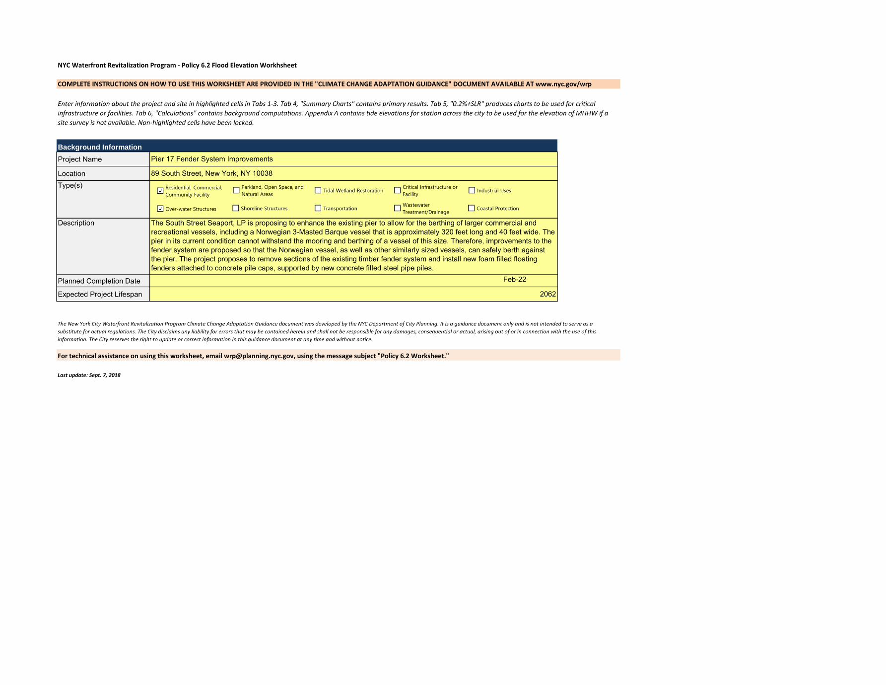
NYC Waterfront Revitalization Program - Policy 6.2 Flood Elevation Workhsheet
COMPLETE INSTRUCTIONS ON HOW TO USE THIS WORKSHEET ARE PROVIDED IN THE "CLIMATE CHANGE ADAPTATION GUIDANCE" DOCUMENT AVAILABLE AT www.nyc.gov/wrp
Background Information
Project Name
Location
Planned Completion Date Feb-22
Expected Project Lifespan
Last update: Sept. 7, 2018
Enter information about the project and site in highlighted cells in Tabs 1-3. Tab 4, "Summary Charts" contains primary results. Tab 5, "0.2%+SLR" produces charts to be used for critical
infrastructure or facilities. Tab 6, "Calculations" contains background computations. Appendix A contains tide elevations for station across the city to be used for the elevation of MHHW if a
site survey is not available. Non-highlighted cells have been locked.
Type(s)
Description
Pier 17 Fender System Improvements
89 South Street, New York, NY 10038
For technical assistance on using this worksheet, email [email protected], using the message subject "Policy 6.2 Worksheet."
The New York City Waterfront Revitalization Program Climate Change Adaptation Guidance document was developed by the NYC Department of City Planning. It is a guidance document only and is not intended to serve as a
substitute for actual regulations. The City disclaims any liability for errors that may be contained herein and shall not be responsible for any damages, consequential or actual, arising out of or in connection with the use of this
information. The City reserves the right to update or correct information in this guidance document at any time and without notice.
2062
The South Street Seaport, LP is proposing to enhance the existing pier to allow for the berthing of larger commercial and
recreational vessels, including a Norwegian 3-Masted Barque vessel that is approximately 320 feet long and 40 feet wide. The
pier in its current condition cannot withstand the mooring and berthing of a vessel of this size. Therefore, improvements to the
fender system are proposed so that the Norwegian vessel, as well as other similarly sized vessels, can safely berth against
the pier. The project proposes to remove sections of the existing timber fender system and install new foam filled floating
fenders attached to concrete pile caps, supported by new concrete filled steel pipe piles.
Residential, Commercial,
Community Facility
Parkland, Open Space, and
Natural AreasTidal Wetland Restoration
Critical Infrastructure or
FacilityIndustrial Uses
Over-water Structures Shoreline Structures TransportationWastewater
Treatment/DrainageCoastal Protection

Establish current tidal and flood heights.
FT (NAVD88) Feet Datum Source
MHHW 2.17 2.17 NAVD88 Vdatum
1% flood height 15.00 15.00 NAVD88 Pfirm
Design flood elevation 15.00 15.00 NAVD88 Pfirm
As relevant:
0.2% flood height -->
Data will be converted based on the following datums:
Datum FT (NAVD88)
NAVD88 0.00
NGVD29 -1.10
Manhattan Datum 1.65
Bronx Datum 1.51
Brooklyn Datum (Sewer) 0.61
Brooklyn Datum (Highway) 1.45
Queens Datum 1.63
Richmond Datum 2.09

Ft Above Ft Above Ft Above
Lifespan Elevation Units Datum Ft NAVD88 MHHW 0.2% flood height
Steel Pipe Pile with Concrete Cap 2062 8.2 Feet NAVD88 8.2 8.2 6.0 #VALUE!
B Feet NAVD88
C Feet NAVD88
D Feet NAVD88
E Feet NAVD88
F Feet NAVD88
G Feet NAVD88
H Feet NAVD88
Description of Planned Uses and Materials
Description of Planned Uses and Materials
Describe key physical features of the project.
26 steel pipe piles with concrete caps will be installed along the pier.
Description of Planned Uses and Materials
Feature (enter name) Feature Category
Description of Planned Uses and Materials
Description of Planned Uses and Materials
Description of Planned Uses and Materials
Description of Planned Uses and Materials
Vulnerable Critical Potentially Hazardous Other
Vulnerable Critical Potentially Hazardous Other
Vulnerable Critical Potentially Hazardous Other
Vulnerable Critical Potentially Hazardous Other
Vulnerable Critical Potentially Hazardous Other
Critical Potentially Hazardous Other
Other
Vulnerable Critical Potentially Hazardous Other
Vulnerable
Vulnerable Critical Potentially Hazardous

SLR PROJECTIONS SLR PROJECTIONS
High High
High-Mid High-Mid
Mid Mid
Low-Mid Low-Mid
Low Low
Assess project vulnerability over a range of sea level rise projections.
Steel Pipe Pile with Concrete Cap
BCDEFGH0
2
4
6
8
10
Baseline 2020s 2050s 2080s 2100
Feet
ab
ove
NA
VD
88
Mean Higher High Water + Sea Level Rise
Steel Pipe Pile with Concrete Cap
BCDEFGH
DFE
0
2
4
6
8
10
12
14
16
18
20
22
24
Baseline 2020s 2050s 2080s 2100
Feet
ab
ove
NA
VD
88
1% Flood Elevation + Sea Level Rise

Steel Pipe Pile with Concrete Cap
BCDEFGH0
2
4
6
8
10
12
14
16
18
20
22
24
26
28
30
Baseline 2020s 2050s 2080s 2100
Fee
t ab
ove
NA
VD
88
0.2% Flood Elevation + Sea Level Rise

Low Low-Mid Mid High-Mid High
Baseline 0.00 0.00 0.00 0.00 0.00 2014
2020s 0.17 0.33 0.50 0.67 0.83 2020s
2050s 0.67 0.92 1.33 1.75 2.50 2050s
2080s 1.08 1.50 2.42 3.25 4.83 2080s
2100 1.25 1.83 3.00 4.17 6.25 2100
Low Low-Mid Mid High-Mid High
Baseline 2.17 2.17 2.17 2.17 2.17
2020s 2.34 2.50 2.67 2.84 3.00
2050s 2.84 3.09 3.50 3.92 4.67
2080s 3.25 3.67 4.59 5.42 7.00
2100 3.42 4.00 5.17 6.34 8.42
Low Low-Mid Mid High-Mid High
Baseline 15.00 15.00 15.00 15.00 15.00
2020s 15.17 15.33 15.50 15.67 15.83
2050s 15.67 15.92 16.33 16.75 17.50
2080s 16.08 16.50 17.42 18.25 19.83
2100 16.25 16.83 18.00 19.17 21.25
Low Low-Mid Mid High-Mid High
Baseline #VALUE! #VALUE! #VALUE! #VALUE! #VALUE!
2020s #VALUE! #VALUE! #VALUE! #VALUE! #VALUE!
2050s #VALUE! #VALUE! #VALUE! #VALUE! #VALUE!
2080s #VALUE! #VALUE! #VALUE! #VALUE! #VALUE!
2100 #VALUE! #VALUE! #VALUE! #VALUE! #VALUE!
0 1
Steel Pipe Pile with Concrete Cap 8 8.2
B 0 0
C 0 0
D 0 0
E 0 0
F 0 0
G 0 0
H 0 0
DFE 15.00 15.00
0.2%+SLR (ft above NAVD88)
SLR (ft)
MHHW+SLR (ft above NAVD88)
1%+SLR (ft above NAVD88)
SLR (in)

Low Low-Mid Mid High-Mid High
0 0 0 0 0
2 4 6 8 10
8 11 16 21 30
13 18 29 39 58
15 22 36 50 75
SLR (in)
March 2021
Section VI
Site Photos

Pier 17
Fender System Improvements
Section VI March 2021 Page 1 of 3
Photograph 1 - General view of the Pier 17 looking West.
Photograph 2 – General view of the Pier 17 from the North side.
06/26/2018
06/26/2018

Pier 17
Fender System Improvements
Section VI March 2021 Page 2 of 3
Photograph 3 – View of the existing timber piles.
Photograph 4 – View of the existing timber piles.
06/26/2018
06/26/2018

Pier 17
Fender System Improvements
Section VI March 2021 Page 3 of 3
Photograph 5 - General view of the fender system looking East.
Photograph 6 – View of the top of the fender system.
02/25/2021
02/25/2021

March 2021
Section VII
Drawings

THE HOWARD HUGHES CORPORATION199 WATER STREET, 28TH FLOORNEW YORK, NY
PIER 17 FENDER SYSTEMIMPROVEMENTS
FILE NAME: P:\Proj210\210036\10_Dwgs\CADD\ACOE Permit Drawings\Location Map.dwg PLOT TIME: Fri, 12 Mar 2021 - 5:57pm LAST SAVE: Wed, 24 Feb 2021 - 1:56pm BY: BMarquez
03/15/2021
NYNEW YORK STATE:PIER 17MANHATTAN
SEE ATTACHED LISTADJACENT OWNERS:DATUM: NAVD88
PURPOSE:
SHT OF
COUNTY OF:AT:IN:
AGENT:
APPLICANT:
PIER FENDERIMPROVEMENTS
14
M.G. McLaren Engineeringand Land Surveying, P.C.530 Chestnut Ridge RoadWoodcliff Lake, NJ 07677
1.0 LOCATION MAP
1
SCALE: NOT TO SCALE
NORT
HNO
RTH
LATITUDE: 40°42'18.32" NLONGITUDE: 74°0'3.95" W

THE HOWARD HUGHES CORPORATION199 WATER STREET, 28TH FLOORNEW YORK, NY
PIER 17 FENDER SYSTEMIMPROVEMENTS
FILE NAME: P:\Proj210\210036\10_Dwgs\CADD\ACOE Permit Drawings\Vicinity Map.dwg PLOT TIME: Fri, 12 Mar 2021 - 5:57pm LAST SAVE: Thu, 11 Feb 2021 - 5:15pm BY: BMarquez
03/15/2021
NYNEW YORK STATE:PIER 17MANHATTAN
SEE ATTACHED LISTADJACENT OWNERS:DATUM: NAVD88
PURPOSE:
SHT OF
COUNTY OF:AT:IN:
AGENT:
APPLICANT:
PIER FENDERIMPROVEMENTS
14
M.G. McLaren Engineeringand Land Surveying, P.C.530 Chestnut Ridge RoadWoodcliff Lake, NJ 07677
2.0 VICINITY MAP
2
SCALE: NOT TO SCALE
NORT
HNO
RTH
LATITUDE: 40°42'18.32" NLONGITUDE: 74°0'3.95" W

THE HOWARD HUGHES CORPORATION199 WATER STREET, 28TH FLOORNEW YORK, NY
PIER 17 FENDER SYSTEMIMPROVEMENTS
FILE NAME: P:\Proj210\210036\10_Dwgs\CADD\ACOE Permit Drawings\Tidal Datum Chart.dwg PLOT TIME: Fri, 12 Mar 2021 - 5:57pm LAST SAVE: Wed, 24 Feb 2021 - 1:56pm BY: BMarquez
03/15/2021
NYNEW YORK STATE:PIER 17MANHATTAN
SEE ATTACHED LISTADJACENT OWNERS:DATUM: NAVD88
PURPOSE:
SHT OF
COUNTY OF:AT:IN:
AGENT:
APPLICANT:
PIER FENDERIMPROVEMENTS
14
M.G. McLaren Engineeringand Land Surveying, P.C.530 Chestnut Ridge RoadWoodcliff Lake, NJ 07677
3.0 TIDAL DATUM CHART
3
SCALE: NO SCALE
DATUM CHART
DESCRIPTION NOAA MLLW
MHWNAVD '88
MLWMLLW
MHHW
MTL
NAVD '88
0.00'
NGVD '29
1. TIDAL DATUM ELEVATIONS OBTAINED USING NOAA VDATUM VERSION 3.6.1, DATA SET FOR "NEWJERSEY/NEW YORK/CONNECTICUT-NORTHERN NJ, NY HARBOR, WESTERN LONG ISLAND SOUND,VERSION 2.2".-COORDINATES FOR VDATUM:
LAT.: 40°42'18.32"NLONG.: 74°0'3.95"W
2. * FEMA 100 YEAR ELEVATIONS OBTAINED FROM FEDERAL EMERGENCY MANAGEMENT AGENCYMAP ENTITLED, "NEW YORK CITY PRELIMINARY FIRM DATA VIEWER"., MAP PANEL NUMBER3604970184G, DATED 12/05/2013.3. ** HIGHEST OBSERVED WATER LEVEL (HOWL) AND LOWEST OBSERVED WATER LEVEL (LOWL) DATATAKEN FROM TIDE STATION 8518750, THE BATTERY, NY, EPOCH 1983-2001.4. ALL ELEVATIONS SHOWN IN FEET REFER TO N.A.V.D. '88.
0.70'
NGVD '29
0.21'
NOAA MHHW
0.00'
-1.11'
-0.33'
-2.63'
1.81'
2.17' 3.28'
2.92'
1.11'
0.78'
0.00'
-1.52'
1.73'
2.43'
2.51'
2.84'
4.65'
5.01'
-0.36'
-2.17'
-2.50'
-2.58'
-3.28'
-4.80'
0.00'-2.84' -1.73'-5.01'
DTL
LMSL -0.29' 0.82' 2.55'-2.46'
-0.41'
* FEMA AE 12 9.83' 13.11'
14.11
16.11'
14.84'
15.84'
17.84
12.00'
13.00'
15.00'
10.83'
12.83'
* FEMA AE 13
* FEMA VE 15
** HOWL (10-30-2012) 11.27'9.10' 12.38' 14.11'
** LOWL (2-2-1976) -4.22'-7.06' -5.95'-9.23'
MHWS 0.18' 2.35' 3.46' 5.19'

-13.
0
-16.
0
-15.
0-1
4.0
-20.
0-19.0-18.
0
-17.0
-21.0
EXIST.MARKETBLDG. PIER
EXISTING 12"Ø TIMBERFENDER PILE (TYP.)
EXISTING 12x12WALE (TYP.)
357'-5"
EXISTING 12x12x12TIMBER BLOCK (TYP.)
EXISTING 10x12CHOCK (TYP.)
35 3931 43413733292725
T/DECK EL. 8.2'
3'-0"
A6.0
THE HOWARD HUGHES CORPORATION199 WATER STREET, 28TH FLOORNEW YORK, NY
PIER 17 FENDER SYSTEMIMPROVEMENTS
FILE NAME: P:\Proj210\210036\10_Dwgs\CADD\ACOE Permit Drawings\Existing and Proposed Plan.dwg PLOT TIME: Fri, 12 Mar 2021 - 5:57pm LAST SAVE: Fri, 12 Mar 2021 - 5:56pm BY: BMarquez
03/15/2021
NYNEW YORK STATE:PIER 17MANHATTAN
SEE ATTACHED LISTADJACENT OWNERS:DATUM: NAVD88
PURPOSE:
SHT OF
COUNTY OF:AT:IN:
AGENT:
APPLICANT:
PIER FENDERIMPROVEMENTS
14
M.G. McLaren Engineeringand Land Surveying, P.C.530 Chestnut Ridge RoadWoodcliff Lake, NJ 07677
4.0 EXISTING SITE PLAN-1
4
0 30' 60'
NORTH
EXISTING SITE PLAN - 1NOTE: MHWS, MHW, AND MLW ARE LOCATED FURTHER INSHORE ANDNOT VISIBLE ON THIS PLAN DUE TO THE SCALE OF THE DRAWING.

-25.
0
-24.
0-2
3.0-22.
0
-21.0
-34.
0
-33.
0
-32.
0
-31.
0-3
0.0
-29.
0-2
8.0
-27.
0
-26.
0
-31.
0
-34.
0
-35.
0
-40.
0 -45.
0 -48.
0
-47.
0
-50.
0-5
1.0
-49.
0
-47.
0-4
8.0
-46.
0-4
5.0
EXISTING 12x12x12TIMBER BLOCK (TYP.)
EAST
RIV
EREB
B FLOO
D
EXISTING 10x12CHOCK (TYP.)
357'-5"
APPR
OXIM
ATE
U.S.
PIE
RHEA
D LIN
E
EXISTING 12"Ø TIMBERFENDER PILE (TYP.)
EXISTING 12x12WALE (TYP.)
605957555351494745
C
D
E
F
G
T/DECK EL. 12.92'
3'-0"
THE HOWARD HUGHES CORPORATION199 WATER STREET, 28TH FLOORNEW YORK, NY
PIER 17 FENDER SYSTEMIMPROVEMENTS
FILE NAME: P:\Proj210\210036\10_Dwgs\CADD\ACOE Permit Drawings\Existing and Proposed Plan.dwg PLOT TIME: Fri, 12 Mar 2021 - 5:58pm LAST SAVE: Fri, 12 Mar 2021 - 5:56pm BY: BMarquez
03/15/2021
NYNEW YORK STATE:PIER 17MANHATTAN
SEE ATTACHED LISTADJACENT OWNERS:DATUM: NAVD88
PURPOSE:
SHT OF
COUNTY OF:AT:IN:
AGENT:
APPLICANT:
PIER FENDERIMPROVEMENTS
14
M.G. McLaren Engineeringand Land Surveying, P.C.530 Chestnut Ridge RoadWoodcliff Lake, NJ 07677
5.0 EXISTING SITE PLAN-2
5
0 30' 60'
NORTH
A6.0
EXISTING SITE PLAN - 2NOTE: MHWS, MHW, AND MLW ARE LOCATED FURTHER INSHORE ANDNOT VISIBLE ON THIS PLAN DUE TO THE SCALE OF THE DRAWING.

T/DECK EL. +8.2'±
MLW EL. -2.63'
EXISTING TIMBER FENDERPILE, 8'-0" O.C.
EXISTING TIMBER CHOCK(TYP.)
EXISTING TIMBER WALE(TYP.)
EXISTING TIMBERBLOCKING (TYP.) T/CONCRETE DECK EL. +6.65'±
EXISTING TIMBERDECKING
EXISTING RAILING
EXISTING CONCRETEPILE CAP
EXISTING CONCRETE FILLEDSTEEL PIPE PILE
EXISTING PRESTRESSEDPRECAST CONCRETE PLANK
MHW EL. +1.81'
MUDLINEELEVATION VARIES
PILE TIP EL. -51.65'
MHWS EL. +2.35'
3'-0"
THE HOWARD HUGHES CORPORATION199 WATER STREET, 28TH FLOORNEW YORK, NY
PIER 17 FENDER SYSTEMIMPROVEMENTS
FILE NAME: P:\Proj210\210036\10_Dwgs\CADD\ACOE Permit Drawings\Sections.dwg PLOT TIME: Fri, 12 Mar 2021 - 5:58pm LAST SAVE: Fri, 12 Mar 2021 - 5:06pm BY: BMarquez
03/15/2021
NYNEW YORK STATE:PIER 17MANHATTAN
SEE ATTACHED LISTADJACENT OWNERS:DATUM: NAVD88
PURPOSE:
SHT OF
COUNTY OF:AT:IN:
AGENT:
APPLICANT:
PIER FENDERIMPROVEMENTS
14
M.G. McLaren Engineeringand Land Surveying, P.C.530 Chestnut Ridge RoadWoodcliff Lake, NJ 07677
6.0 EXISTING SECTION
6
0 2' 4' 8'
A6.0
TYPICAL EXISTING FENDER SYSTEM SECTION1/4" = 1'-0"

-13.
0
-16.
0
-15.
0-1
4.0
-20.
0-19.0-18.
0
-17.0
-21.0
EXIST.MARKETBLDG. PIER
357'-5"
REMOVE SECTIONS OF EXISTINGFENDER SYSTEM AS NECESSARYFOR PILE CAP INSTALLATION (TYP.)
35 3931 43413733292725
14'-2" 40'-0" 24'-0" 39'-0" 17'-0" 40'-0"
THE HOWARD HUGHES CORPORATION199 WATER STREET, 28TH FLOORNEW YORK, NY
PIER 17 FENDER SYSTEMIMPROVEMENTS
FILE NAME: P:\Proj210\210036\10_Dwgs\CADD\ACOE Permit Drawings\Existing and Proposed Plan.dwg PLOT TIME: Fri, 12 Mar 2021 - 5:58pm LAST SAVE: Fri, 12 Mar 2021 - 5:56pm BY: BMarquez
03/15/2021
NYNEW YORK STATE:PIER 17MANHATTAN
SEE ATTACHED LISTADJACENT OWNERS:DATUM: NAVD88
PURPOSE:
SHT OF
COUNTY OF:AT:IN:
AGENT:
APPLICANT:
PIER FENDERIMPROVEMENTS
14
M.G. McLaren Engineeringand Land Surveying, P.C.530 Chestnut Ridge RoadWoodcliff Lake, NJ 07677
7.0 DEMOLITION PLAN-1
7
0 30' 60'
NORTH
DEMOLITION PLAN - 1NOTE: MHWS, MHW, AND MLW ARE LOCATED FURTHER INSHORE ANDNOT VISIBLE ON THIS PLAN DUE TO THE SCALE OF THE DRAWING.

-25.
0
-24.
0-2
3.0-22.
0
-21.0
-34.
0
-33.
0
-32.
0
-31.
0-3
0.0
-29.
0-2
8.0
-27.
0
-26.
0
-31.
0
-34.
0
-35.
0
-40.
0 -45.
0 -48.
0
-47.
0
-50.
0-5
1.0
-49.
0
-47.
0-4
8.0
-46.
0-4
5.0
EAST
RIV
EREB
B FLOO
D
357'-5"
APPR
OXIM
ATE
U.S.
PIE
RHEA
D LIN
E
605957555351494745
C
D
E
F
G
24'-0" 56'-0" 24'-0" 56'-0" 7'-3" 15'-0"
REMOVE SECTIONS OF EXISTINGFENDER SYSTEM AS NECESSARYFOR PILE CAP INSTALLATION (TYP.)
THE HOWARD HUGHES CORPORATION199 WATER STREET, 28TH FLOORNEW YORK, NY
PIER 17 FENDER SYSTEMIMPROVEMENTS
FILE NAME: P:\Proj210\210036\10_Dwgs\CADD\ACOE Permit Drawings\Existing and Proposed Plan.dwg PLOT TIME: Fri, 12 Mar 2021 - 5:58pm LAST SAVE: Fri, 12 Mar 2021 - 5:56pm BY: BMarquez
03/15/2021
NYNEW YORK STATE:PIER 17MANHATTAN
SEE ATTACHED LISTADJACENT OWNERS:DATUM: NAVD88
PURPOSE:
SHT OF
COUNTY OF:AT:IN:
AGENT:
APPLICANT:
PIER FENDERIMPROVEMENTS
14
M.G. McLaren Engineeringand Land Surveying, P.C.530 Chestnut Ridge RoadWoodcliff Lake, NJ 07677
8.0 DEMOLITION PLAN-2
8
0 30' 60'
NORTH
B9.0
DEMOLITION PLAN - 2NOTE: MHWS, MHW, AND MLW ARE LOCATED FURTHER INSHORE ANDNOT VISIBLE ON THIS PLAN DUE TO THE SCALE OF THE DRAWING.
T/DECK EL. +8.2'±
MLW EL. -2.63'
T/CONCRETE DECK EL. +6.65'±
EXISTING TIMBERDECKING
EXISTING RAILING
EXISTING CONCRETEPILE CAP
EXISTING CONCRETE FILLEDSTEEL PIPE PILE
EXISTING PRESTRESSEDPRECAST CONCRETE PLANK
EXISTING TIMBER FENDERPILE TO BE REMOVED
EXISTING TIMBER CHOCKTO BE REMOVED
EXISTING TIMBER WALETO BE REMOVED
EXISTING TIMBER BLOCKINGTO BE REMOVED
MHW EL. +1.81'
MUDLINEELEVATION VARIES
PILE TIP EL. -51.65'
MHWS EL. +2.35'
3'-0"
THE HOWARD HUGHES CORPORATION199 WATER STREET, 28TH FLOORNEW YORK, NY
PIER 17 FENDER SYSTEMIMPROVEMENTS
FILE NAME: P:\Proj210\210036\10_Dwgs\CADD\ACOE Permit Drawings\Sections.dwg PLOT TIME: Fri, 12 Mar 2021 - 5:58pm LAST SAVE: Fri, 12 Mar 2021 - 5:06pm BY: BMarquez
03/15/2021
NYNEW YORK STATE:PIER 17MANHATTAN
SEE ATTACHED LISTADJACENT OWNERS:DATUM: NAVD88
PURPOSE:
SHT OF
COUNTY OF:AT:IN:
AGENT:
APPLICANT:
PIER FENDERIMPROVEMENTS
14
M.G. McLaren Engineeringand Land Surveying, P.C.530 Chestnut Ridge RoadWoodcliff Lake, NJ 07677
9.0 DEMOLITION SECTION
9
0 2' 4' 8'
B9.0
TYPICAL FENDER DEMOLITION SECTION1/4" = 1'-0"
NOTE: SIX (6) OF THE EXISTING TIMBER PILES TO BE REMOVED SHALLBE PULLED AND REUSED AT LOCATIONS INDICATED ON THE PLANS.
LEGEND:
TIMBER FENDER SYSTEM TO BE REMOVED
-13.
0
-16.
0
-15.
0-1
4.0
-20.
0-19.0-18.
0
-17.0
-21.0
EXIST.MARKETBLDG. PIER
356'-5"±
20'-0"40'-0"20'-0"40'-0"20'-0"17'-3"±
STATSRAAD LEHMKUHL
PROPOSEDPILE CAP (TYP.)
321'-10"
PROPOSED 5'Øx10'FOAM FILLED FLOATINGFENDER (TYP.)
277'-6"
35 3931 43413733292725
RELOCATED TIMBERPILES (6 LOCATIONS)
6'-0"
9'-6"
THE HOWARD HUGHES CORPORATION199 WATER STREET, 28TH FLOORNEW YORK, NY
PIER 17 FENDER SYSTEMIMPROVEMENTS
FILE NAME: P:\Proj210\210036\10_Dwgs\CADD\ACOE Permit Drawings\Existing and Proposed Plan.dwg PLOT TIME: Fri, 12 Mar 2021 - 5:58pm LAST SAVE: Fri, 12 Mar 2021 - 5:56pm BY: BMarquez
03/15/2021
NYNEW YORK STATE:PIER 17MANHATTAN
SEE ATTACHED LISTADJACENT OWNERS:DATUM: NAVD88
PURPOSE:
SHT OF
COUNTY OF:AT:IN:
AGENT:
APPLICANT:
PIER FENDERIMPROVEMENTS
14
M.G. McLaren Engineeringand Land Surveying, P.C.530 Chestnut Ridge RoadWoodcliff Lake, NJ 07677
10.0 PROPOSED PLAN-1
10
0 30' 60'
NORTH
C12.0
D13.0
PROPOSED PLAN - 1
LEGEND:EXISTING 12" DIA. TIMBER PILERELOCATED 12" DIA. TIMBER PILENEW 24" DIA. STEEL PIPE PILE
NOTE: MHWS, MHW, AND MLW ARE LOCATED FURTHER INSHORE ANDNOT VISIBLE ON THIS PLAN DUE TO THE SCALE OF THE DRAWING.

-25.
0
-24.
0-2
3.0-22.
0
-21.0
-34.
0
-33.
0
-32.
0
-31.
0-3
0.0
-29.
0-2
8.0
-27.
0
-26.
0
-31.
0
-34.
0
-35.
0
-40.
0 -45.
0 -48.
0
-47.
0
-50.
0-5
1.0
-49.
0
-47.
0-4
8.0
-46.
0-4
5.0
20'-0"40'-0"20'-0"40'-0" 49'-3"±
21'-3"
20'-0"
20'-0"
EAST
RIV
EREB
B FLOO
D
277'-6"
41'-4
"
321'-10"
356'-5"±
10'-0"
APPR
OXIM
ATE
U.S.
PIE
RHEA
D LIN
E
PROPOSEDPILE CAP (TYP.)
PROPOSED 5'Øx10'FOAM FILLED FLOATINGFENDER (TYP.)
605957555351494745
C
D
E
F
G
RELOCATED TIMBERPILES (6 LOCATIONS)
6'-0"
9'-6"
THE HOWARD HUGHES CORPORATION199 WATER STREET, 28TH FLOORNEW YORK, NY
PIER 17 FENDER SYSTEMIMPROVEMENTS
FILE NAME: P:\Proj210\210036\10_Dwgs\CADD\ACOE Permit Drawings\Existing and Proposed Plan.dwg PLOT TIME: Fri, 12 Mar 2021 - 5:58pm LAST SAVE: Fri, 12 Mar 2021 - 5:56pm BY: BMarquez
03/15/2021
NYNEW YORK STATE:PIER 17MANHATTAN
SEE ATTACHED LISTADJACENT OWNERS:DATUM: NAVD88
PURPOSE:
SHT OF
COUNTY OF:AT:IN:
AGENT:
APPLICANT:
PIER FENDERIMPROVEMENTS
14
M.G. McLaren Engineeringand Land Surveying, P.C.530 Chestnut Ridge RoadWoodcliff Lake, NJ 07677
11.0 PROPOSED PLAN-2
11
0 30' 60'
NORTH
C12.0
D13.0
PROPOSED PLAN - 2
LEGEND:EXISTING 12" DIA. TIMBER PILERELOCATED 12" DIA. TIMBER PILENEW 24" DIA. STEEL PIPE PILE
NOTE: MHWS, MHW, AND MLW ARE LOCATED FURTHER INSHORE ANDNOT VISIBLE ON THIS PLAN DUE TO THE SCALE OF THE DRAWING.

C12.0
PROPOSED FENDER SYSTEM SECTION1/4" = 1'-0"
T/EL. +8.2'±
NEW FOAM FILLEDFLOATING FENDER
EXISTING TIMBERDECKING
EXISTING CONCRETEPILE CAP
EXISTING CONCRETE FILLEDSTEEL PIPE PILE
EXISTING RAILING
T/CONCRETE DECK EL. +6.65'±PROPOSED 4'x4'
CONCRETE PILE CAP
NEW 24"Ø x 12" THK. WALL CONCRETEFILLED STEEL PIPE PILE
T-HEAD MOORING BOLLARD(30 TON CAPACITY)
NOTE: EXISTING TIMBER FENDERING NOT SHOWN FOR CLARITY.
EXISTING PRESTRESSEDPRECAST CONCRETE PLANK
CONCRETE PAD
3'-0"
9"4'-
0"
MLW EL. -2.63'
MHW EL. +1.81'
MUDLINEELEVATION VARIES
60'-0
" MIN
.EM
BEDM
ENT
MHWS EL. +2.35'
12x12 FRP WALE (TYP.)
4x8 FRP BLOCK (TYP.)
1" THK. NEOPRENEPAD
1 14
5'-0" 4'-0"
9'-0"
THE HOWARD HUGHES CORPORATION199 WATER STREET, 28TH FLOORNEW YORK, NY
PIER 17 FENDER SYSTEMIMPROVEMENTS
FILE NAME: P:\Proj210\210036\10_Dwgs\CADD\ACOE Permit Drawings\Sections.dwg PLOT TIME: Fri, 12 Mar 2021 - 5:58pm LAST SAVE: Fri, 12 Mar 2021 - 5:06pm BY: BMarquez
03/15/2021
NYNEW YORK STATE:PIER 17MANHATTAN
SEE ATTACHED LISTADJACENT OWNERS:DATUM: NAVD88
PURPOSE:
SHT OF
COUNTY OF:AT:IN:
AGENT:
APPLICANT:
PIER FENDERIMPROVEMENTS
14
M.G. McLaren Engineeringand Land Surveying, P.C.530 Chestnut Ridge RoadWoodcliff Lake, NJ 07677
12.0 PROPOSED FENDERSYSTEM SECTION
12
0 2' 4' 8'

8'-0"
D13.0
PROPOSED FENDER SYSTEM ELEVATION1/4" = 1'-0"
14'-0"
PROPOSED 4'x4'CONCRETE PILE CAP
T-HEAD MOORING BOLLARD(30 TON CAPACITY)
4'-0"
NEW 24"Ø x 12" THK. WALLCONCRETE FILLED STEEL
PIPE PILE (TYP.)
NOTE: EXISTING TIMBER FENDERING & RAILING NOT SHOWN FOR CLARITY.
MOUNTING CHAINS ANDHARDWARE (TYP.)
3'-0" 3'-0"PILE
4'-0"
9" EMBED.(TYP.)
PILE
MLW EL. -2.63'
MHW EL. +1.81'
MUDLINEELEVATION VARIES
60'-0
" MIN
.EM
BEDM
ENT
MHWS EL. +2.35'EXISTING PIER
10'-0"FRP WALE
NEW FOAM FILLED FLOATINGFENDER (5'-0"Ø x 10'-0" LONG)
1 14
11 4
THE HOWARD HUGHES CORPORATION199 WATER STREET, 28TH FLOORNEW YORK, NY
PIER 17 FENDER SYSTEMIMPROVEMENTS
FILE NAME: P:\Proj210\210036\10_Dwgs\CADD\ACOE Permit Drawings\Sections.dwg PLOT TIME: Fri, 12 Mar 2021 - 5:58pm LAST SAVE: Fri, 12 Mar 2021 - 5:06pm BY: BMarquez
03/15/2021
NYNEW YORK STATE:PIER 17MANHATTAN
SEE ATTACHED LISTADJACENT OWNERS:DATUM: NAVD88
PURPOSE:
SHT OF
COUNTY OF:AT:IN:
AGENT:
APPLICANT:
PIER FENDERIMPROVEMENTS
14
M.G. McLaren Engineeringand Land Surveying, P.C.530 Chestnut Ridge RoadWoodcliff Lake, NJ 07677
13.0 PROPOSED FENDERSYSTEM ELEVATION
13
0 2' 4' 8'

THE HOWARD HUGHES CORPORATION199 WATER STREET, 28TH FLOORNEW YORK, NY
PIER 17 FENDER SYSTEMIMPROVEMENTS
FILE NAME: P:\Proj210\210036\10_Dwgs\CADD\ACOE Permit Drawings\Proposed Table.dwg PLOT TIME: Fri, 12 Mar 2021 - 5:58pm LAST SAVE: Fri, 26 Feb 2021 - 12:12pm BY: BMarquez
03/15/2021
NYNEW YORK STATE:PIER 17MANHATTAN
SEE ATTACHED LISTADJACENT OWNERS:DATUM: NAVD88
PURPOSE:
SHT OF
COUNTY OF:AT:IN:
AGENT:
APPLICANT:
PIER FENDERIMPROVEMENTS
14
M.G. McLaren Engineeringand Land Surveying, P.C.530 Chestnut Ridge RoadWoodcliff Lake, NJ 07677
14.0 PROPOSED TABLES
14
SCALE: NO SCALE
PROPOSED CUT AND FILL ANALYSIS
BELOW MHWSBELOW MHW
CUT (CY)
REMOVAL OF EXISTINGTIMBER PILES
ACTION FILL (CY) CUT (CY) FILL (CY)
42 0 43 0
INSTALLATION OFPROPOSED FENDER
SYSTEM0 128 0 130
TOTAL 87 CY OF FILL86 CY OF FILL
PROPOSED OVERWATER COVERAGE
REMOVAL OF SECTIONS OFEXISTING FENDER SYSTEM
INSTALLATION OF PROPOSEDFENDER SYSTEM
NET OVERWATERCOVERAGE ADDED
515 SF
1455 SF
940 SF

March 2021
Section VIII
Essential Fish Habitat Worksheet
NOAA Fisheries Greater Atlantic Regional Fisheries Office Essential Fish Habitat (EFH) Assessment & Fish and Wildlife Coordination
Act (FWCA) Worksheet This worksheet is your essential fish habitat (EFH) assessment. It provides us with the information necessary to assess the effects of your action on EFH
NOAA trust resources under theFish and Wildlife Coordination Act (FWCA). Consultation is not required if:
1. there is no adverse effect on EFH or NOAA trust resources (see page 10 for more info).2. no EFH is designated and no trust resources may be present at the project site.
InstructionsFederal agencies or their non-federal designated lead agency should email the completedworksheet and necessary attachments to [email protected]. Include the public notice (if applicable) or project application and project plans showing:
location map of the project site with area of impact.existing and proposed conditions.all waters of the U.S. on the project site with mean low water (MLW), mean high water(MHW), high tide line (HTL), and water depths clearly marked.sensitive habitats mapped, including special aquatic sites (submerged aquatic vegetation,saltmarsh, mudflats, riffles and pools, coral reefs, and sanctuaries and refuges), hardbottom or natural rocky habitat areas, and shellfish beds.site photographs, if available.
We will provide our EFH conservation recommendations and recommendations under the FWCA, as appropriate, within 30 days of receipt of a complete EFH assessment (60 days if an expanded consultation is necessary). Please submit complete information to minimize delays in completing the consultation.
This worksheet provides us with the information required1 in an EFH assessment: 1. A description of the proposed action.2. An analysis of the potential adverse effects on EFH and the federally managed species.3. The federal agency’s conclusions regarding the effects of the action on EFH.4. Proposed mitigation, if applicable.
Your analysis should focus on impacts that reduce the quality and/or quantity of the habitat or result in conversion to a different habitat type for all life stages of species with designated EFH within the action area.
Use the information on the HCD website and NOAA’s EFH Mapper to complete this worksheet. If you have questions, please contact the appropriate HCD staff member to assist you.
1 The EFH consultation process is guided by the requirements of our EFH regulation at 50 CFR 600.905.
1

EFH ASSESSMENT WORKSHEET
General Project Information
Date Submitted: 03/22/2021
Project/Application Number:
Project Name:
Project Sponsor/Applicant:
Federal Action Agency (if state agency acting as delegated):
Fast-41 or One Federal Decision Project: Yes No
Action Agency Contact Name:
Contact Phone: Contact Email:
Latitude: Longitude:
Address, City/Town, State:
Body of Water:
Project Purpose:
Project Description:
Anticipated Duration of In-Water Work or Start/End Dates:
2
TBD following Permit Application Submission
Pier 17 Fender System Improvements
South Street Seaport, LP
USACE
✔
M.G. McLaren Engineering and Land Surveying, P.C.
(201) 775-6000
74°,00' 03.95"W
40°, 42' 18.32"N
89 South Street, New York, NY 10038
East River
The client is looking to enhance the existing pier to make it capable of berthing aNorwegian 3-Masted Barque vessel.
The South Street Seaport, LP is proposing to enhance the existing pier to allow for theberthing of larger commercial and recreational vessels, including a Norwegian3-Masted Barque vessel that is approximately 320 feet long and 40 feet wide. The pierin its current condition cannot withstand the load of a vessel of this size. Therefore,improvements to the fender system are proposed so that the Norwegian vessel, aswell as other similarly sized vessels, can safely berth against the pier. The projectproposes to remove sections of the existing timber fender system and install new foamfilled floating fenders attached to concrete pile caps, supported by new concrete filledsteel pipe piles. There will be thirteen floating fenders connected to concrete pile caps,each supported by two concrete filled 24-inch diameter steel pipe piles. The pile capswill each support one 5 foot diameter by 10 foot foam filled floating fender.
April 2021 - February 2022

Habitat Description
EFH includes the biological, chemical, and physical components of the habitat. This includes the substrate and associated biological resources (e.g., benthic organisms, submerged aquatic vegetation, shellfish beds, salt marsh wetlands), the water column, and prey species.
Is the project in designated EFH2? Yes No
Is the project in designated HAPC2? Yes No
Is this coordination under FWCA only? Yes No
Total area of impact to EFH (indicate sq ft or acres):
Total area of impact to HAPC (indicate sq ft or acres):
Current water depths: Salinity: Water temperature range:
Sediment characteristics3:
What habitat types are in or adjacent to the project area and will they be permanently impacted? Select all that apply. Indicate if impacts will be temporary, if site will be restored, or if permanent conversion of habitat will occur. A project may occur in overlapping habitat types.
Habitat Type Total impact (sq ft/acres)
Impacts are temporary
Restored to pre-existing conditions
Permanent conversion of all or part of habitat
Marine
Estuarine
Riverine (tidal)
Riverine (non-tidal)
Intertidal
Subtidal
Water column
Salt marsh/ Wetland (tidal)
Wetland (non-tidal)
2 Use the tables on pages 7-9 to list species with designated EFH or the type of designated HAPC present. 3 The level of detail is dependent on your project – e.g., a grain size analysis may be necessary for dredging.
3
✔
✔
✔
720 SF
720 SF
14 - 25 18 - 26 psu 39 - 72° F
silt, sand with gravel, organic silt and clay
✔ 240 SF No No Yes, 240 SF
✔ 240 SF No No Yes, 240 SF
✔ 240 SF No No Yes, 240 SF

Habitat Type Total impact (sq ft/acres)
Impacts are temporary
Restored to pre-existing conditions
Permanent conversion of all or part of habitat
Rocky/hard bottom4:
Sand
Shellfish beds or oyster reefs
Mudflats
Submerged aquatic vegetation (SAV)5,macroalgae, epifauna
Diadromous fish (migratory or spawning habitat)
Indicate type(s) of rocky/hard bottom habitat (pebble, cobble, boulder, bedrock outcrop/ledge) and species of SAV:
Project Effects
Select all that apply
Project Type/Category
Hatchery or Aquaculture
Agriculture
Forestry
Military (e.g., acoustic testing, training exercises)
Mining (e.g., sand, gravel)
Restoration or fish/wildlife enhancement (e.g., fish passage, wetlands, beach renourishment, mitigation bank/ILF creation)
4 Indicate type(s). The type(s) of rocky habitat will help you determine if the area is cod HAPC. 5 Indicate species. Provide a copy of the SAV report and survey conducted at the site, if applicable.
4
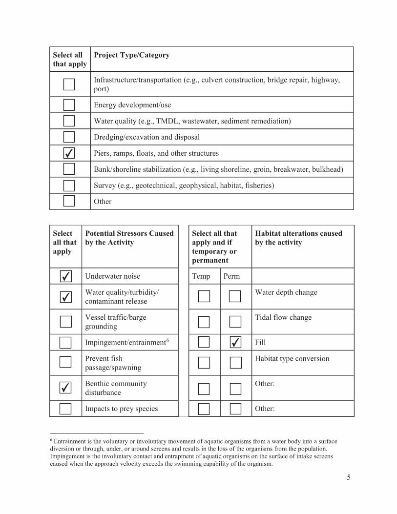
Select all that apply
Project Type/Category
Infrastructure/transportation (e.g., culvert construction, bridge repair, highway, port)
Energy development/use
Water quality (e.g., TMDL, wastewater, sediment remediation)
Dredging/excavation and disposal
Piers, ramps, floats, and other structures
Bank/shoreline stabilization (e.g., living shoreline, groin, breakwater, bulkhead)
Survey (e.g., geotechnical, geophysical, habitat, fisheries)
Other
Select all that apply
Potential Stressors Caused by the Activity
Select all that apply and if temporary or permanent
Habitat alterations caused by the activity
Underwater noise Temp Perm
Water quality/turbidity/ contaminant release
Water depth change
Vessel traffic/barge grounding
Tidal flow change
Impingement/entrainment6 Fill
Prevent fish passage/spawning
Habitat type conversion
Benthic community disturbance
Other:
Impacts to prey species Other:
6 Entrainment is the voluntary or involuntary movement of aquatic organisms from a water body into a surface diversion or through, under, or around screens and results in the loss of the organisms from the population. Impingement is the involuntary contact and entrapment of aquatic organisms on the surface of intake screens caused when the approach velocity exceeds the swimming capability of the organism.
5
✔
✔
✔
✔
✔
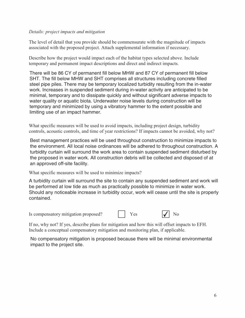
Details: project impacts and mitigation
The level of detail that you provide should be commensurate with the magnitude of impacts associated with the proposed project. Attach supplemental information if necessary.
Describe how the project would impact each of the habitat types selected above. Include temporary and permanent impact descriptions and direct and indirect impacts.
What specific measures will be used to avoid impacts, including project design, turbidity controls, acoustic controls, and time of year restrictions? If impacts cannot be avoided, why not?
What specific measures will be used to minimize impacts?
Is compensatory mitigation proposed? Yes No
If no, why not? If yes, describe plans for mitigation and how this will offset impacts to EFH. Include a conceptual compensatory mitigation and monitoring plan, if applicable.
6
There will be 86 CY of permanent fill below MHW and 87 CY of permanent fill belowSHT. The fill below MHW and SHT comprises all structures including concrete filledsteel pipe piles. There may be temporary localized turbidity resulting from the in-waterwork. Increases in suspended sediment during in-water activity are anticipated to beminimal, temporary and to dissipate quickly and without significant adverse impacts towater quality or aquatic biota. Underwater noise levels during construction will betemporary and minimized by using a vibratory hammer to the extent possible andlimiting use of an impact hammer.
✔

Federal Action Agency’s EFH determination (select one)
There is no adverse effect7 on EFH or EFH is not designated at the project site.
EFH Consultation is not required. This is a FWCA-only request.
The adverse effect7 on EFH is not substantial. This means that the adverse effects are no more than minimal, temporary, or can be alleviated with minor project modifications or conservation recommendations.
This is a request for an abbreviated EFH consultation.
The adverse effect7 on EFH is substantial.
This is a request for an expanded EFH consultation. We will provide more detailed information, including an alternatives analysis and NEPA document, if applicable.
EFH and HAPC designations8
Use the EFH mapper to determine if EFH may be present in the project area and enter all species and lifestages that have designated EFH. Optionally, you may review the EFH text descriptions linked to each species in the EFH mapper and use them to determine if the described habitat is present. We recommend this for larger projects to help you determine what your impacts are.
Species EFH is designated/mapped for:
Habitat present based on text description (optional)
EFH: eggs
EFH: larvae
EFH: juvenile
EFH: adults/ spawning adults
7 An adverse effect is any impact that reduces the quality and/or quantity of EFH. Adverse effects may include direct or indirect physical, chemical, or biological alterations of the waters or substrate and loss of, or injury to, benthic organisms, prey species and their habitat, and other ecosystem components. Adverse effects to EFH may result from actions occurring within EFH or outside of EFH and may include site-specific or habitat-wide impacts, including individual, cumulative, or synergistic consequences of actions.8 Within the Greater Atlantic Region, EFH has been designated by the New England, Mid-Atlantic, and South Atlantic Fisheries Management Councils and NOAA Fisheries.
7
✔
Winter Flounder ✔ ✔ ✔ ✔
Little Skate ✔ ✔
Atlantic Herring ✔ ✔ ✔
Red Hake ✔ ✔ ✔ ✔

Species EFH is designated/mapped for:
Habitat present based on text description (optional)
EFH: eggs
EFH: larvae
EFH: juvenile
EFH: adults/ spawning adults
8
Windowpane Flounder ✔ ✔ ✔ ✔
Winter Skate ✔ ✔
Clearnose Skate ✔ ✔
Longfin Inshore Squid ✔
Bluefish ✔ ✔
Atlantic Butterfish ✔
Summer Flounder ✔ ✔ ✔

HAPCs
Select all that are in your action area.
Summer flounder: SAV9 Alvin & Atlantis Canyons
Sandbar shark Baltimore Canyon
Sand Tiger Shark (Delaware Bay) Bear Seamount
Sand Tiger Shark (Plymouth-Duxbury-Kingston Bay)
Heezen Canyon
Inshore 20m Juvenile Cod Hudson Canyon
Great South Channel Juvenile Cod Hydrographer Canyon
Northern Edge Juvenile Cod Jeffreys & Stellwagen
Lydonia Canyon Lydonia, Gilbert & Oceanographer Canyons
Norfolk Canyon (Mid-Atlantic) Norfolk Canyon (New England)
Oceanographer Canyon Retriever Seamount
Veatch Canyon (Mid-Atlantic) Toms, Middle Toms & Hendrickson Canyons
Veatch Canyon (New England) Washington Canyon
Cashes Ledge Wilmington Canyon
9 Summer flounder HAPC is defined as all native species of macroalgae, seagrasses, and freshwater and tidal macrophytes in any size bed, as well as loose aggregations, within adult and juvenile summer flounder EFH. In locations where native species have been eliminated from an area, then exotic species are included. Use local information to determine the locations of HAPC.
9
✔

More information
The Magnuson-Stevens Fishery Conservation and Management Act (MSA) mandates that federal agencies conduct an essential fish habitat (EFH) consultation with NOAA Fisheries on any actions they authorize, fund, or undertake that may adversely affect EFH. An adverse effect is any impact that reduces the quality and/or quantity of EFH. Adverse effects may include direct or indirect physical, chemical, or biological alterations of the waters or substrate and loss of, or injury to, benthic organisms, prey species and their habitat, and other ecosystem components. Adverse effects to EFH may result from actions occurring within EFH or outside of EFH and may include site-specific or habitat-wide impacts, including individual, cumulative, or synergistic consequences of actions.
We designed this worksheet to help you to prepare EFH assessments. It is important to remember that an adverse effect determination is a trigger to consult with us. It does not mean that a projectcannot proceed as proposed, or that project modifications are necessary. It means that the effects of the proposed action on EFH must be evaluated to determine if there are ways to avoid, minimize, or offset adverse effects.
This worksheet should be used as your EFH assessment or as a guide to develop your EFH assessment. At a minimum, you should include all the information required to complete this worksheet in your EFH assessment. The level of detail that you provide should be commensurate with the magnitude of impacts associated with the proposed project. If your answers in the worksheet and supplemental information you attach do not fully evaluate the adverse effects to EFH, we may request additional information to complete the consultation.
You may need to prepare an expanded EFH assessment for more complex projects to fully characterize the effects of the project and the avoidance and minimization of impacts to EFH. While the EFH assessment worksheet may be used for larger projects, the format may not be sufficient to incorporate the extent of detail required, and a separate EFH assessment may be developed. However, regardless of format, you should include an analysis as outlined in this worksheet for an expanded EFH assessment, along with any additional necessary information. This additional information includes:
the results of on-site inspections to evaluate the habitat and site-specific effects.the views of recognized experts on the habitat or the species that may be affected.a review of pertinent literature and related information.an analysis of alternatives that could avoid or minimize the adverse effects on EFH.
Please contact our Greater Atlantic Regional Fisheries Office, Protected Resources Division regarding potential impacts to marine mammals or threatened and endangered species.
10
Useful Links National Wetland Inventory Maps https://www.fws.gov/wetlands/ EPA’s National Estuary Program (NEP) https://www.epa.gov/nep/local-estuary-programs Northeast Regional Ocean Council (NROC) Data Portal https://www.northeastoceandata.org/ Mid-Atlantic Regional Council on the Ocean (MARCO) Data Portal http://portal.midatlanticocean.org/
Resources by State
Maine Maine Office of GIS Data Catalog https://geolibrary-maine.opendata.arcgis.com/datasets#data Town shellfish information including shellfish conservation area maps https://www.maine.gov/dmr/shellfish-sanitation -management/programs/municipal/ordinances/towninfo.html State of Maine Shellfish Sanitation and Management https://www.maine.gov/dmr/shellfish-sanitation-management/index.html Eelgrass maps https://www.maine.gov/dmr/science-research/species/eelgrass/index.html Casco Bay Estuary Partnership https://www.cascobayestuary.org/ Maine GIS Stream Habitat Viewer https://www.arcgis.com/home/item.html?id=5869c2d20f0b4c3a9742bdd8abef42cb
New Hampshire NH’s Statewide GIS Clearinghouse, NH GRANIT http://www.granit.unh.edu/ NH Coastal Viewer http://www.granit.unh.edu/nhcoastalviewer/ State of NH Shellfish Program https://www.des.nh.gov/organization/divisions/water/wmb/shellfish/
Massachusetts MA Shellfish Sanitation and Management Program https://www.mass.gov/shellfish-sanitation-and-management MassGIS Data, Including Eelgrass Maps http://maps.massgis.state.ma.us/map_ol/oliver.php MA DMF Recommended TOY Restrictions Document https://www.mass.gov/files/documents/2016/08/ry/tr-47.pdf Massachusetts Bays National Estuary Program https://www.mass.gov/orgs/massachusetts-bays-national-estuary-program Buzzards Bay National Estuary Program http://buzzardsbay.org/ Massachusetts Division of Marine Fisheries
11

https://www.mass.gov/orgs/division-of-marine-fisheries Massachusetts Office of Coastal Zone Management https://www.mass.gov/orgs/massachusetts-office-of-coastal-zone-management
Rhode Island RI Shellfish and Aquaculture http://www.dem.ri.gov/programs/fish-wildlife/marine-fisheries/shellfish-aquaculture.php RI Shellfish Management Plan http://www.shellfishri.com/ Eelgrass Maps http://edc.maps.arcgis.com/apps/View/index.html?appid=db52bb689c1e44259c06e11fd24895f8 RI GIS Data http://ridemgis.maps.arcgis.com/apps/webappviewer/index.html?id=87e104c8adb449eb9f905e5f 18020de5 Narragansett Bay Estuary Program http://nbep.org/ Rhode Island Division of Marine Fisheries http://www.dem.ri.gov/programs/fish-wildlife/marine-fisheries/index.php Rhode Island Coastal Resources Management Council http://www.crmc.ri.gov/
Connecticut CT Bureau of Aquaculture https://www.ct.gov/doag/cwp/view.asp?a=3768&q=451508&doagNav= CT GIS Resources https://www.ct.gov/deep/cwp/view.asp?a=2698&q=323342&deepNav_GID=1707 Natural Shellfish Beds in CT https://cteco.uconn.edu/viewer/index.html?viewer=aquaculture Eelgrass Maps https://www.fws.gov/northeast/ecologicalservices/pdf/wetlands/2012_CT_Eelgrass_Final_Repor t_11_26_2013.pdf Long Island Sound Study http://longislandsoundstudy.net/ CT GIS Resources http://cteco.maps.arcgis.com/home/index.html CT DEEP Office of Long Island Sound Programs and Fisheries https://www.ct.gov/deep/site/default.asp CT River Watershed Council https://www.ctriver.org/
New York Eelgrass Report http://www.dec.ny.gov/docs/fish_marine_pdf/finalseagrassreport.pdf Peconic Estuary Program https://www.peconicestuary.org/ NY/NJ Harbor Estuary https://www.hudsonriver.org/estuary-program
12

New York GIS Clearinghouse https://gis.ny.gov/
New Jersey Submerged Aquatic Vegetation Mapping http://www.crssa.rutgers.edu/projects/sav/ Barnegat Bay Partnership https://www.barnegatbaypartnership.org/ NJ GeoWeb https://www.nj.gov/dep/gis/geowebsplash.htm NJ DEP Shellfish Maps https://www.nj.gov/dep/landuse/shellfish.html
Pennsylvania Delaware River Management Plan https://www.fishandboat.com/Fish/Fisheries/DelawareRiver/Documents/delaware_river_plan_ex ec_draft.pdf PA DEP Coastal Resources Management Program https://www.dep.pa.gov/Business/Water/Compacts%20and%20Commissions/Coastal%20Resour ces%20Management%20Program/Pages/default.aspx PA DEP GIS Mapping Tools https://www.dep.pa.gov/DataandTools/Pages/GIS.aspx
Delaware Partnership for the Delaware Estuary http://www.delawareestuary.org/ Center for Delaware Inland Bays http://www.inlandbays.org/ Delaware FirstMap http://delaware.maps.arcgis.com/home/index.html
Maryland Submerged Aquatic Vegetation Mapping http://web.vims.edu/bio/sav/ MERLIN http://dnrweb.dnr.state.md.us/MERLIN/ Maryland Coastal Bays Program https://mdcoastalbays.org/
Virginia Submerged Aquatic Vegetation mapping http://www.mrc.virginia.gov/regulations/Guidance_for_SAV_beds_and_restoration_final_appro ved_by_Commission_7-22-17.pdf VDGIF Time of Year Restrictions (TOYR) and Other Guidance https://www.dgif.virginia.gov/wp-content/uploads/VDGIF-Time-of-Year-Restrictions-Table.pdf
13

March 2021
Appendix A
Previously Issued NYSDEC Permit
(Issued 10/01/2008 – Expired 09/30/2018)

I . NEW YORK STAT E DEPARTMENT OF ENVIRONMENTAL CONSERVATION Facility DEC 1D 2-6500-00037
PERMIT Under the Environmental Conservation Law
Permittee and Facility Information
Permit Issued To: Facility: NYC ECONOMIC DEVELOPMENT CORP NYC EDC - CITY-WIDE
----1. I 0-WILLIAM--SI- ----======-------'CII..Y...WI.DE. ___ _________ _ __ _ NEW YORK, NY 10038-3901 NEW YORK, NY (2 12) 6 19-5000
Facility Location: in SEVERAL COUNTIES in THIS REGION Village: New York C ity Facility Principal Reference Point: NYTM-E: NYTM-N:
Latitude: Longitude: Project Location: Surface waters, tida l wetlands, and regulated ti dal wetlands adjacent areas Authorized Activity: Maintenance of New York City-owned , legal waterfront structures, or elements thereof, as de fined in the special conditions of thi s permit, by the New York City Economic Development Corporation w ithin New York C ity.
Tidal Wetlands - Undet· Article 25 Permit I'D 2-6500-00037/00001
Permit Authorizations
Renewal Effect ive Date: I 011/2008 Expiration Date: 9/30/20 18 Water Quality Certification- Under Section 401 -Clean Water Act · Permit ID 2-6500-00037/00003
Renewal Effective Date: I 0/1/2008 Expiration Date: 9/30/20 18 Excavation & Fill in Navigable Waters- Under Article 15, Title 5 Permi t ID 2-6500-00037/00005
Renewal Effecti ve Date: I 011 /2008 Expiration Date: 9/30/20 18
NYSDEC Approval
By accepta nce of this permit, the permittee agrees that the permit is contingent upon strict compliance with the ECL, all applicable regulations, and all conditions included as part of this permit.
Permit Admi nistrator: JOHN F CRY AN, Regional Permit Administrator Address: NYSDEC REGION 2 HEADQUARTERS
47-40 2 1ST ST LONG ISLAND CITY Y I l l 0 I -5407
Authori zed Signature:
Page 1 of 9

NEW YORK STATE DEPARTMENT OF ENVIRONMENTAL CONSERVATION Facility DEC 10 2-6500-00037
Permit Components
NATURAL RESOURCE PERMIT CONDITIONS
WATER QUALITY CERTIFICATION SPECIFIC CONDITION
GENERAL CONDITIONS, APPLY TO ALL AUTHORIZED PERMITS
NOT!riCA TION OF OTHER PERMITTEE OBLIGATIONS
NATURAL RESOURCE PERMIT CONDITIONS- Apply to the Following Permits: TIDAL WETLANDS; WATER QUALITY CERTIFICATION;
EXCAVATION & FILL IN NAVIGABLE WATERS
I. Conformance With Plans All activities authorized by this permit must be in stri ct conformance with the approved plans submitted by the applicant or applicant's agent as part of the permit applicat ion. Such approved plans were prepared by New York City Economic Development or agent's of the New York City Economic Development.
2. Scope of General Permit Maintenance of legal waterfront structures, or elements thereof, maintained by New York City Economic Development Corporation.
-Piers, wharves, bulkheads, bridge piers, bridge/pier protection cells, ferry landing structures, and stone revetments involving the following elements:
-Piles (wood*, concrete, steel , concrete fil led steel) ; -Pi le caps; -Beams, fenders and walers; -Decking; -Gravity walls; -Timber, vinyl or steel sheet pile bulkheads** (in-place reconstruction only) -Relieving platforms; -Cribbing; -Spalled concrete surfaces (repair to be application of shotcrete or other method of pneumatically applied concrete or formed with cast-in-place concrete); -Cathodic protection of metal surfaces; -Storm water outfall(s) and tide gates- limited to in-place repair or rep lacement of an outfall(s) or tide gate due to deterioration or to maintenance of the waterfront structure of which it is a part; -Repair or replacement oflegal marine habitat enhancement structures (ie. reef balls, etc.) in-place due to deterioration or due to maintenance of the waterfront structure of which it is a part; -Repair, replacement or relocation of impervious or pervious service roads located greater than thirty (30) feet landward of the tidal wetland boundary; -In-place repair or replacement of boat ramps (for security and emergency use only with no asphalt) due to deterioration or due to maintenance of the waterfront structure of which it is a part; -Aids to navigation - prior approval by and installed in accordance with the requirements of the U.S . Coast Guard.
Page 2of9

NEW YORK STATE DEPARTMENT OF ENVIRONMENTAL CONSERVATION Facility DEC ID 2-6500-00037
*including wrapping of timber piles with plastic sheeting (a maximum increase of 6 inches in diameter) to prevent or minimize deterioration (including manual side casting and replacement of sediment at the base of pile to facilitate placement of sheeting below the mudline).
*concrete jacketing/encasement (limited to initial jackets/encasements with a maximum 8 inch increase in diameter) of damaged or deteriorated piles (also including manual side casting and replacement of sediment at the base of pile to fac il itate placement of sheeting below the mud-line). Second generation jackets/encasements are not covered under the scope of this permit.
**excavation of incidental obstructions (rip rap, fill material, debris) from the base of deteriorated piles, bulkhead or other deteriorated retaining structures sections to fac il itate maintenance work.
**replacement of ri p rap provided it be underlain it with gee-tex tile fabric at base of repaired and/or reconstructed bulkhead sections or under or adjacent to piers and wharves to re-establi sh structural stability. ·
3. Definitions a) Maintenance: The repair or in-place replacement of any functional waterfront structure provided that the structure is not to be put to uses differing from lawfully allowed past uses or from those specified in prior permi ts. Minor deviations in the structure's configuration or filled area including those due to changes in materials, construction techniques, or current construction codes or safety standards which are necessary to make repair or replacement are permitted, provided the environmental impacts resulting from such repair are not significant.
b) Incidental: Occuring merely by chance or without intention or calculation, with minor consequence.
c) Minimal Impacts: Those that are consistent with a SEQR finding of no signi ficant impacts.
d) Minor Deviations: Those changes to the in-place characteri sti cs of the structure that are consistent with a SEQR finding of no significant impacts; 6 NYCRR Part 66 1.5 use catergory of GCP (generally compatible use-permit required) ; and applicable development restrictions contained in 6 NYCRR Part 66 1.6.
c) Repair: To bring back to or put back into a former or original state, including replacement in part or whole.
f) Replacement: The filling of a place once occupied by something lost, destroyed, deteriorated, or no longer usable or adequate.
g) Shotcrctc: A quick sett ing mortar or concrete mix pneumatically conveyed through a hose and applied directly to vertical and overhead surfaces, being capable of supporting itself without sagging or sloughing: suitable for repair work anci new construction.
4. Regulated Activities Authorized by this Pennit This permit authori zes only those regulated acti vities/structures identified in Natural Resources Permit Condition 2. NYSDEC does not issue afterthe-fact or as-bui lt permits. This permit does not authorize activities, or legitimize the existence of structures, which would have required a permit but for which no permit or other authorization has been granted by NYSDEC.
5. Notification to NYSDEC Not less than fifteen ( 15) days prior to the start of work, New York City EDC must provide one copy of the fo llowing items to: NYSDEC Division of Environmental Permits,
Page 3 of 9

NEW YORK STATE DEPARTMENT OF ENVIRONMENTAL CONSERVATION Facility DEC ID 2-6500-00037
47-40 21st Street, Long Island City, New York 11101 (Attention: Regional Permit Administrator) and one copy ofthe following to: NYSDEC Bureau of Marine Resources, 47-40 21st Street, Long Island City, New York Ill 0 l (Attention: Marine Resources Program Manager).
a. Project Description
b. Work Schedule
c. Curt ent co luqJlmto-grapi~mwing'lhe--entire--projeclSi te-at-J-owti-de-;-including-photo~------====-------=
location/direction labeling plan.
d. Construction equipment to be used.
e. Project plans to scale which include the following:
l) Sediment/erosion controls methods/locations if any sediment/vegetation disturbance or fill placement is proposed.
2) Tidal wetland boundary, mean high water and mean low water line locations and elevations referenced to NAD 88.
3) Staging locations for storage of construction equipment/materials. 4) Temporary or permanent project limiting fence. 5) Access route for construction equipment 6) Type(s) and volume(s) and source(s) of fill to be used if applicable 7) North arrow 8) Property lines and names of adjacent landowners 9) Dimensions of the work areas and limits of disturbance I 0) Name of preparer and date prepared II) Typc(s) and dimensions (in feet/inches) of material proposed 12) Ex isting and proposed grades 13) Dimensions/weights (in pounds) and amount(s) (in cubic yards) of rock rip rap if
applicable.
6. Notice of Intent to Commence Work At least 15 days prior to commencement of work, Permitte must complete and return the attached Notice of Intent to Commence Work to: NYSDEC Marine Resources, 47-40 21st Street, Long Island City, New York 11101 (Attention: Marine Resources Program Manager).
7. Post Permit Sign The permi t sign enclosed with this permit shall be posted in a conspicuous locat ion on the worksite and adequately protected from the weather.
8. Post Construction Photographs Within 30 days of the completion of work authorized by this permit , Permittee must submit post-construction photographs of the work area to: NYSDEC Bureau of Marine Resources, 47-40 2 1st Street, Long Island City, New York 11 101 (Attention: Marine Resources Program Manager).
9. Best Management Practices Best management practices must be employed to prevent the loss of construction materials, debris and sediments from entering the wetlands or waterways. Such practices may include, but are not limited to, construction fencing, staked hay bales, si lt fencing, floating platforms, netting, containment booms.
Page 4 of9
NEW YORK STATE DEPARTMENT OF ENVIRONMENTAL CONSERVATION Facility DEC 10 2-6500-00037
10. Precautions Against Contamination of Waters All necessary precautions shall be taken to preclude contamination of any wetland or waterway by suspended so lids, sediments, fuels, solvents, lubricants, epoxy coatings, paints, concrete, leachate or any other environmentally deleterious materials associated with the project.
II. Concrete/Leachate Discharges Prohibited During construction, concrete or leachate must not escape or be discharged, and washings from transit mix trucks, mixers, or other devices must not enter tidal wetlands or protected buffer areas or waterways.
12. Storage of Construction Equipment and Materials The storage of construction equipment and newly delivered construct ion materials must be confined to within the project work site and upland areas greater than 50 linear feet from the tidal wetland boundary.
13. Excavation for Bulkhead/Structure Prior to any construction or removal of bulkheads and other shoreline stabilization structures all backfi ll shall be excavated landward of the structure and retained so as not to enter the waterway, tidal wetland or protected buffer area.
14. Complete Construction Before Backfilling Construction of all peripheral riprap berms, cofferdams, rock revetment, gabions, bulkheads, etc., shall be completed prior to placement of any fi ll material behind such structures.
15. Clean Fill Material Only All fi II material must consist of "clean" sand, gravel, or soil. The use of material such as asphalt, slag, fly-ash, broken concrete, recycled concrete aggregate or demolition debris is strictly prohibited.
16. Installation of Pilings All pilings must be driven in place. The jetting of pilings is prohibited.
17. No Disturbance to Vegetated Tidal Wetlands is allowed. There will be no disturbance to vegetated tidal wetlands or tidal wetlands adjacent area protected buffe r areas as a result of the permitted activity.
18. No Floats, Ramps in Vegetated Tidal Wetlands Floats and ramps may not rest on or be stored in any vegetated tidal wetland.
19. Debris Removal Should any demolition or construction debris fall into the waterway or enter the tidal wetlands, it must be removed immediately.
20. Debris Disposal All demolition and construction debris must be properly di sposed of at a fac ility permitted to accept such materials.
21. De-Watering Prohibited De-watering is prohibited without prior written approval from NYSDEC.
22. No Construction Debris in Wetland or Adjacent Area Debris from the construction project permitted herein, and any excess construction materials, may not enter or be stored within regulated wetlands or adjacent areas. Such debris must be removed on a daily basis from the project site, and such excess materials must be removed before the end of construction.
23. In-Water Usc of Wood Preservatives A. Pressure treated wood used for construction of in-water structures must have been treated with a preservative and must have undergone a treatment process approved (stamped or otherwise marked as certified) by the American Wood Preservative Association.
Page 5 of9

NEW YORK STATE DEPARTMENT OF ENVIRONMENTAL CONSERVATION Facility DEC ID 2-6500-00037
B. Wood treated with Pentachlorophenol (PCP) must not be used in wetlands or surface waters.
C I. [Existing Marinas] Wood treated with creosote may only be used until January I, 20 I 0.
Any unused creosote treated wood must be disposed of in accordance with section 27-2505 of the Environmental Conservation Law at a specially authori zed facility. The burning of creosote treated wood is strictly prohibited.
C2. [New Marinas] The use of creosote treated wood is prohibited both in the water and in the upland areas.
D. Chroma ted Copper Arsenate (CCA) pressure treated wood must be clean and free of CCA smface deposits. Wood with surface deposits must be washed for at least 5 minutes under running water prior to use. (Note the following condition for the handling of wash water.)
E. Any wood debris such as sawdust or wash water must not enter any water body, including wetlands, or protected buffer areas.
24. Stabilize Disturbed Areas All areas of soil disturbance resulting from this project shall be stabili zed immediately following project completion or prior to permit expiration, whichever comes fi rst. The approved methodologies are as follows:
a. Stabilization of the entire disturbed area with appropriate vegetation (grasses, etc.).
b. Stabilized as per specifications identified on approved plans.
c. Temporarily stabilized with straw mulch or jute matting or other simi lar natmal fiber matting within I week of final grading. Temporary stabilization shall be maintained until a mature vegetative cover is established.
25. Minimize Adverse Impacts to Wetlands, Wildlife, Water All work must be performed in a manner which minimizes adverse impacts to wetlands, wildlife, water quality and natural resources.
26. No Interference With Navigation There shall be no unreasonable interference with navigation by the work herein authori zed.
27. Prior Approval of Changes If the Permittee desires to make any changes in construction techniques, species to be planted, the site plan, any mitigation plan, schedul ing or staging of construction, or any other aspect of this project, the Permittee shall submit a written request to the Regional Permit Administrator to make such proposed changes and shall not make such changes unless authorized in writing by the Department.
28. Failure to Meet Permit Conditions Failure of the permittee to meet all the conditions of this permit is a violation of this permit and grounds for an order to immediately cease the permitted acti vity at the project site.
29. State May Require Site Restoration If upon the expiration or revocation of this permit, the project hereby authori zed has not been completed, the applicant shall, without expense to the State, and to such extent and in such time and manner as the Department of Environmental Conservation may
Page 6 of9

NEW YORK STATE DEPARTMENT OF ENVIRONM ENTAL CONSERVATION Facility DEC 10 2-6500-00037
requi re, remove all or any portion of the uncompleted structure or fill and restore the site to its former condition. No claim shall be made against the State of New York on account of any such removal or alteration.
30. State May Order Removal or Alteration of Work If future operations by the State of New York require an alteration in the position of the structure or work herein authori zed, or if, in the opinion of the Department of Environmental Conservation it shall cause unreasonable obstruction to the free navigation of said waters or flood flows or endanger the health, safety or welfare of the people of the State, or cause
--- - 1· ess-eHiesW~;~e+ien-ef-t.A-~-rulli:ffilf-resettt:c-0s--e-l=-t-~1~tate,-+h0-0WH0t'-m~w-ee---Gffiet:eEI-Gy-the-O.epa-t:t-t=Hent,..w.----
rcmove or alter the structural work, obstructions, or hazards caused thereby without expense to the State, and if, upon the expiration or revocation of this permit, the structure, fi ll , excavation, or other modification of the watercourse hereby authorized shall not be completed, the owners, shall , without expense to the State, and to such extent and in such time and manner as the Department of Environmental Conservation may require, remove all or any portion of the uncompleted structure or fill and restore to its former condition the navigable and flood capacity of the watercourse. No claim shall be made against the State of New York on account of any such removal or alteration.
31. State Not Liable for Damage The State of New York shall in no case be liable for any damage or injury to the structure or work herein authorized which may be caused by or result from future operations undertaken by the State for the conservation or improvement of navigation, or for other purposes, and no claim or right to compensation shall accrue from any such damage. ·
WATER QUALITY CERTIFICATION SPECIFIC CONDITIONS
I. Water Quality Certification The NYS Department of Environmental Conservation hereby certifies that the subject project will not contravene efnuent limitations or other limitations or standards under Sections 30 1,302,303,306 and 307 ofthe Clean Water Act of 1977 (PL 95-217) provided that all ofthe conditions listed herein are met.
GENERAL CONDITIONS- Apply to ALL Authorized Pet·mits:
I. Facility Inspection by The Department The permitted site or fac il ity, inc luding relevant records, is subject to inspection at reasonable hours and intervals by an authorized representati ve of the Department of Environmental Conservation (the Department) to determine whether the permittee is complying with this permit and the ECL. Such representative may order the work suspended pursuant to ECL 7 1- 030 I and SAPA 40 I (3).
The permittee shall provide a person to accompany the Department's representative during an inspection to the permit area when requested by the Department.
A copy of this permit, including all referenced maps, drawings and special conditions, must be available for inspection by the Department at all times at the project site or facility. Failure to produce a copy of the permit upon request by a Department representative is a violation of this permit.
2. Relationship of this Permit to Other Department Orders and Determinations Unless express ly provided for by the Department, issuance of this permit does not modify, supersede or rescind any order or determination previously issued by the Department or any of the terms, conditions or requirements conta ined in such order or determination.
Page 7 of9

NEW YORK STATE DEPARTMENT OF ENVIRONMENTAL CONSERVATION Facility DEC 10 2-6500-00037
3. Applications For Permit Renewals, Modifications or Transfers The permittee must submit a separate written application to the Department for permit renewal, modificat ion or transfer of this permit. Such application must include any fo rms or supplemental information the Department requires. Any renewal, modification or transfer granted by the Department must be in wri ting. Submission of applications for permit renewal, modification or transfer are to be submitted to:
Regional Permit Administrator ---------PIJ.-'~9EG--RE-Gl8N-2-HE-A9QtJA-R~ER-S,----::-::::-::=--:-.:-::-:--------------
47-40 21ST ST LONG ISLAND CITY, NYIIIOI -5407
4. Submission of Renewal Application The permittee must submit a renewal appl ication at least 30 days before permit expiration for the following permit authorizations: Excavation & Fill in Navigable Waters, Tidal Wetlands, Water Quality Certification.
5. Permit Modifications, Suspensions and Revocations by the Department The Department reserves the right to modify, suspend or revoke this permit. The grounds for modification, suspension or revocation include:
a. materially false or inaccurate statements in the permit application or supporting papers;
b. failure by the permittee to comply with any terms or conditions of the permit;
c. exceeding the scope of the project as described in the permit application;
d. newly discovered material information or a material change in environmental conditions, relevant technology or applicable law or regulations since the issuance of the existing permit;
c. noncompliance with previously issued permit conditions, orders of the commissioner, any provisions of the Environmental Conservation Law or regulations of the Department related to the permitted activity.
6. Permit Transfer Permits are transferrable unless specifically prohibited by statute, regulation or another permit condition. Applications for permit transfer should be submitted prior to actual transfer of ownership.
NOTIFICATION OF OTHER PERMITTEE OBLIGATIONS
Item A: Permittee Accepts Legal Responsibilit)' and Agrees to Indemnification The permittee, excepting state or fede ral agencies, express ly agrees to indemnify and hold harmless the Department of Environmental Conservation of the State of New York, its representatives, employees, and agents ("DEC") for all claims, suits, actions, and damages, to the extent attributable to the permittee's acts or omissions in connection with the permittee's undertaking of activities in connection with, or operation and maintenance of, the faci lity or fac il ities authorized by the permit whether in compliance or not in compliance with the terms and conditions of the permit. This indemnification does not extend to any claims, suits, actions, or damages to the extent attributable to DEC's own negligent or intentional acts or omissions, or to any claims, suits, or actions naming the DEC and arising under Article 78 of the New York Civil Practice Laws and Rules or any citizen suit or civil rights provision
Page 8 of9

NEW YORK STATE DEPARTM ENT O F ENVIRONM ENTAL CONSERVAT ION Facility DEC ID 2-6500-00037
under federal or state laws.
Item B: Permittee's Contractors to Comply with Permit The permittee is responsible for informing its independent contractors, employees, agents and assigns of their responsibili ty to comply with this permit, including all special conditions while acting as the permittee's agen t with respect to the permitted activities, and such persons shall be subject to the same sanctions for violations of the Environmental Conservation Law as those prescribed for the permittee.
tfem C: Perm rttcl!R~m--t>IJtailliug-Othl!l--itequire-d--p-crmits:---------------
The permittee is responsible for obtaining any other permits, approvals, lands, easements and rights-of-way that may be required to carry out the activities that are authorized by this permit.
Item D: No Right to Trespass or Interfere with Riparian Rights This permit does not convey to the permittee any ri ght to trespass upon the lands or interfere with the riparian rights of others in order to perfo rm the permitted work nor does it authorize the impairment of any rights, title, or interest in real or personal property held or vested in a person not a party to the permit.
Page 9 of9
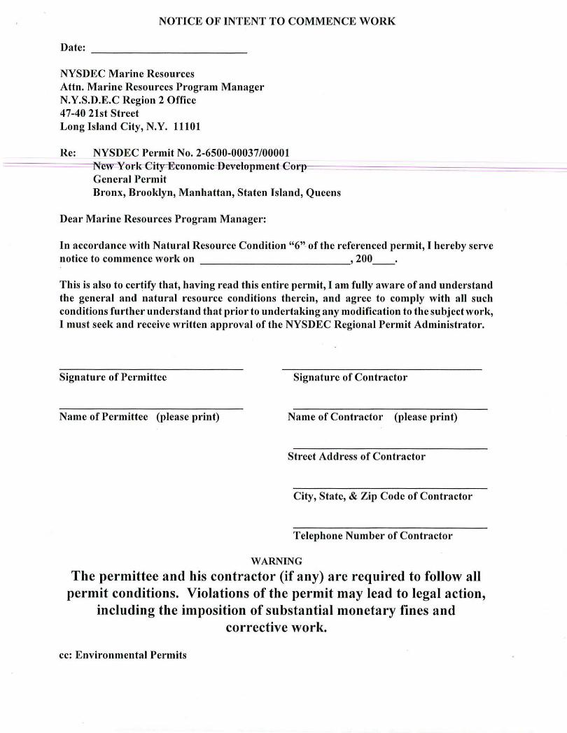
NOTICE OF INTENT TO COMMENCE WORK
Date: ------------
NYSDEC Marine Resources Attn. Marine Resources Program Manager N.Y.S.D.E.C Region 2 Office 47-40 21st Street Long Island City, N.Y. 11101
Re: NYSDEC Permit No. 2-6500-00037/00001 Newl'1Jl'treity-E-conomic--l)evelopment-€orp-" -=----===-------=------------General Permit Bronx, Brooklyn, Manhattan, Staten Island, Queens
Dear Marine Resources Program Manager:
In accordance with Natural Resource Condition "6" of the referenced permit, I hereby serve notice to commence work on , 200 __ .
This is also to certify that, having read this entire permit, I am fully aware of and understand the general and natural resource conditions therein, and agree to comply with all such conditions further understand that prior to undertaking any modification to the subject work, I must seek and receive written approval of the NYSDEC Regional Permit Administrator.
Signature of Permittee Signature of Contractor
Name of Permittee (please print) Name of Contractor (please print)
Street Address of Contractor
City, State, & Zip Code of Contractor
Telephone Number of Contractor
WARNING
The permittee and his contractor (if any) are required to follow all permit conditions. Violations of the permit may lead to legal action,
including the imposition of substantial monetary fines and corrective work.
cc: Environmental Permits

95-20-1 (11/03) -9d
The
New York State partment of Environmental Conservation
NOTICE epartment of Environmental Conservation (DEC) has permit(s) pursuant to the Environmental Conservation r work being conducted at . this site. For further tion regarding the nature and extent of the approved
nd any Department conditions applied to the approval, the Regional Permit Administrator listed below. Please the permit number shown wtwrj\ contqctin~ the DEC.
~~-~ eg~nal Permw~d~~~strator 2-6500-0003 7/00001
Permit Number 1 _________ _ fohn F. Cryan
(47-40 2Pt Stree~ 'LJc, NY 1110 12/31/2018
Expiration Date 1 ________ _ (71~
NOTE: This notice is NOT a permit

530 Chestnut Ridge Road, Woodcliff Lake, NJ 07677Tel: (201) 775-6000 Fax: (201) 746-8522