Embed Size (px)
Citation preview


Environmental Assessment December 2013
NCDOT STIP Project Number B‐2500B Page 1 of 7
iii
NC 12 Replacement of the Herbert C. Bonner Bridge
(Bridge No. 11) over Oregon Inlet
Federal‐Aid Nos. BRS‐2358(15), BRNHF‐0012(55), BRNHF‐0012(56)
NCDOT Project Definition: 32635
TIP Project Nos. B‐2500, B‐2500A, B‐2500B
Dare County, North Carolina
PROJECT COMMITMENTS All Project Commitments listed in Appendix A of the Phase IIa Record of Decision
(ROD) are in effect. The following text lists the Project Commitments (using the same
commitment numbers that were used in the Phase IIa ROD) with direct applicability to
the Phase IIb. No new commitments have been added or revised.
Highway Design Branch and Technical Services Division
2. Bicycle Accommodations. The Cape Hatteras National Seashore (Seashore)
management plan supports the use of bicycles along NC 12. All bridges associated
with the detailed study alternatives (including the Selected Alternative[s]) would
have 8‐foot (2.4‐meter) wide shoulders that would be safer for bicycle and pedestrian
traffic than Bonner Bridge’s 2‐foot (0.6‐meter) wide shoulders. In addition, a bicycle‐
safe bridge rail on the bridges also would provide increased safety for bicyclists.
New roadway would have 4‐foot (1.2‐meter) paved shoulders, which would be safer
for use by bicycle and pedestrian traffic than the existing NC 12’s unpaved
shoulders.
Highway Design Branch and Division 1
3. Use of Work Bridges. During construction of the project, steps taken to minimize
turbidity (when possible and practicable) would include the use of work bridges
(rather than barges, which would require dredging) for movement of construction
equipment in shallow areas where submerged aquatic vegetation (SAV) is present.
If SAV is in waters deep enough to float a barge without dredging, the use of a work
bridge would not be necessary. Work bridges also would be used to carry
construction equipment over intertidal marsh areas (black needlerush and smooth
cordgrass). Dredging generally would only be used in depths less than 6 feet (1.8
meters) where SAV is not present. Work bridges will be used to cross SAVs.
Neither dredging nor haul roads would be used in SAVs.
4. Sedimentation and Erosion Control. All waters in the project area are classified as
SA waters (Class A salt waters) with a supplemental classification of High Quality

Environmental Assessment December 2013
NCDOT STIP Project Number B‐2500B Page 2 of 7
iv
Waters (HQW). The most stringent application of the Best Management Practices
(BMPs) is expected where highway projects affect receiving waters of special
designation, such as HQW. Also, impacts to adjacent areas of SAV and/or wetlands
should be minimized. Therefore, sedimentation and erosion control measures shall
adhere to the Design Standards in Sensitive Watersheds [15A NCAC 04B.0124 (b)‐
(e)]. Prior to construction, the design‐build contractor will submit the proposed
sediment and erosion control plans for each stage of construction to the North
Carolina Department of Transportation (NCDOT) and permitting agencies for
review.
5. Pile Placement. Bridge piles in open water would be jetted to the tip elevation
(depth of the tip of the pile). Bridge piles over land would be jetted or driven.
Potential damage to wetlands, SAV, and Oregon Inlet from jetting spoils will be
minimized to the extent practicable.
Highway Design Branch, Project Development and Environmental Analysis Unit, and
Division 1
8. Design Coordination. NCDOT would invite NPS and USFWS, as well as the other
agencies represented on the project’s National Environmental Policy Act/Section 404
of the Clean Water Act (NEPA/Section 404) Merger Team (a full list of agencies on
the Merger Team is shown on page 8‐6 of the 2008 FEIS), to participate in the
development of project design and mitigation strategies as a part of the permit
application process for each phase of the project
11. Night‐time Construction. Because construction activities could occur 24‐hours‐a‐
day, construction areas could be lit to daylight conditions at night. NCDOT would
work with NCDENR‐DMF, NMFS, NPS, and USFWS to determine other areas near
project construction where night lighting would need to be avoided or limited.
Night lighting also would not be used close to areas where people sleep, including
the campground at the northern end of the project area and the Rodanthe area at the
southern end. Night lighting also will meet the requirements specified to protect sea
turtles contained within Commitment 26.a.
12. Manatee Protection. Construction contracts would require compliance with
USFWS’s Guidelines for Avoiding Impacts to the West Indian Manatee:
Precautionary Measures for Construction Activities in North Carolina Waters (June
2003).
13. Sea Turtle and Smalltooth Sawfish Protection. NCDOT will comply with NMFS’s
March 23, 2006, Sea Turtle and Smalltooth Sawfish Construction Conditions (NMFS,
2006) that restrict in‐water construction‐related activities when these protected
species are observed in the project area. However, NMFS and NCDOT agree that
bridge construction or demolition activities do not need to stop when a protected
Environmental Assessment December 2013
NCDOT STIP Project Number B‐2500B Page 3 of 7
v
species is sighted in the proximity of construction if the construction activities are
not in the water. The in‐water moratorium prohibits pile installation and removal
and activities associated with bridge construction and demolition when listed
species are present in the water, but does not restrict terrestrial activity.
20. Atlantic and Shortnose Sturgeon. Conservation measures to protect shortnose
sturgeon would include no hopper dredging and measures to minimize habitat
degradation. Such measures would include Best Management Practices (BMPs)
involving use, storage, and disposal of construction/demolition materials to
minimize short‐term turbidity or water quality degradation during over‐water
construction in Oregon Inlet and during periodic maintenance. Construction and
demolition activities associated with Phase I of the project would be completed as
quickly as possible in order to minimize deterring spawning sturgeon from entering
Oregon Inlet. In addition, the project would incorporate BMPs to reduce habitat
degradation from stormwater runoff pollution. The same conservation measures
will be applied to the Atlantic sturgeon.
Highway Design Branch, Project Development and Environmental Analysis Unit,
Division 1, Right‐of‐Way Branch, and Technical Services Division
21. Utilities. Project development and construction activities would be coordinated with
utility providers in the project area in order to prevent interruption of local utility
services. The following utility providers currently serve the project area: Dare
County (water service); Sprint Communications (telephone service); Charter
Communications (cable television service); and Cape Hatteras Electric Membership
Association (electric power service).
Project Development and Environmental Analysis Unit
23. Programmatic Agreement. As per the requirements of Section 106 of the National
Historic Preservation Act of 1966, FHWA, the North Carolina State Historic
Preservation Officer (SHPO), the Advisory Council on Historic Preservation
(ACHP), and NCDOT, along with the consulting parties (Dare County, the North
Carolina Aquarium Society, USFWS, NPS, and the Chicamacomico Historical
Association), developed a Programmatic Agreement (PA) stipulating measures that
FHWA will ensure are carried out during the design and construction of the Selected
Alternative to mitigate adverse impacts to the historic cultural resources. The final
PA (see Appendix D of the 2010 ROD) was signed by the signatory agencies on
November 15, 2010 and amended in August 2013 (see Appendix E of the Phase IIa
ROD). NCDOT would carry out the stipulations in this agreement.
24. Seabeach Amaranth. Since the favored habitat of the seabeach amaranth is highly
ephemeral, a survey of the project area would be conducted for the habitat of this
Environmental Assessment December 2013
NCDOT STIP Project Number B‐2500B Page 4 of 7
vi
species at least one year prior to initiating bridge construction activities. It would
occur as needed for each construction phase
Highway Design Branch, Project Development and Environmental Analysis Unit,
Division 1, and Bridge Management Unit
25. Piping Plover. NCDOT will implement the following nondiscretionary measures
that include the terms and conditions outlined in the Biological and Conference
Opinions (USFWS, 2008):
a. All construction equipment and personnel must avoid all bird closure areas
within the Seashore and Refuge.
All future routine maintenance activities of bridge structures that would occur
within or adjacent to current or future plover nesting areas must occur outside
the nesting season (April 1 to July 15).
All future repair work on bridge structures that would occur within or adjacent
to current or future plover nesting areas must occur outside the nesting season
(April 1 to July 15) unless emergency or human safety considerations require
otherwise. In this event, the area must be surveyed for nesting plovers and
avoided to the extent possible.
b. During the construction of Phases II, III and IV of the Phased
Approach/Rodanthe Bridge Alternative (if it is implemented under the NC 12
Transportation Management Plan [Selected Alternative]), keep all construction
equipment and activity within the existing right‐of‐way unless granted approval
by the US Fish and Wildlife Service through a revised protected species
Biological Opinion.
Do not moor any construction barges within 300 feet (91.4 meters) of the
following islands: Green Island, Wells Island, Parnell Island, Island MN, Island
C, the small unnamed island immediately east of Island C, Island D, and Island
G (see Figure 1 in the Biological and Conference Opinions in Appendix E of the 2008
FEIS).
c. All dredge spoil excavated for construction barge access must be used to
augment either existing dredge‐material islands or to create new dredge‐material
islands for use by foraging plovers. This must be accomplished as per the
specifications of the North Carolina Wildlife Resources Commission. If the
dredge material is used outside the current defined action area, the action area is
assumed to be expanded to cover the beneficial placement of the material.

Environmental Assessment December 2013
NCDOT STIP Project Number B‐2500B Page 5 of 7
vii
d. To the maximum extent practical, while ensuring the safety of the traveling
public, limit or avoid the use of road signs or other potential predator perches
adjacent to plover nesting or foraging areas. Where signs or other structures are
necessary, determine if alternative designs would be less conducive for perching
on by avian predators (gulls, crows, grackles, hawks, etc.). For example,
minimize or avoid the use of large cantilever signs in favor of smaller and shorter
designs.
26. Sea Turtles (green sea turtle, leatherback sea turtle, and loggerhead sea turtle).
NCDOT will implement the following nondiscretionary measures that include the
terms and conditions outlined in the Biological and Conference Opinions (USFWS,
2008):
a. All construction equipment and personnel must avoid all marked sea turtle
nests.
Construction material and equipment staging areas must not be located seaward
of the artificial dune.
All future routine maintenance activities of bridge structures that would occur
within or adjacent to current or future sea turtle nesting habitat, and which
would require vehicles or equipment on the beach or the use of night lighting
(excluding navigation lights required by the US Coast Guard), must occur
outside the nesting season (May 1 to November 15).
All future repair work of bridge structures that would occur within or adjacent to
current or future sea turtle nesting habitat, and which would require vehicles or
equipment on the beach or the use of night lighting (excluding navigation lights
required by the US Coast Guard) must occur outside the nesting season (May 1
to November 15) unless emergency or human safety considerations require
otherwise. In this event, the area must be surveyed for sea turtle nests and
avoided to the extent possible.
b. Provide an opportunity for USFWS or a USFWS designee to educate construction
contractor managers, supervisors, foremen and other key personnel and resident
NCDOT personnel with oversight duties (division engineer, resident engineer,
division environmental officer, etc.) as to adverse effects of artificial lighting on
nesting sea turtles and hatchlings, and to the importance of minimizing those
effects.
c. During turtle nesting season (May 1 to November 15), use the minimum number
and the lowest wattage lights that are necessary for construction.
Environmental Assessment December 2013
NCDOT STIP Project Number B‐2500B Page 6 of 7
viii
During turtle nesting season, portable construction lighting must be amber‐
colored LED lights with a predominant wavelength of approximately 650
nanometers (preferred) or low pressure sodium‐vapor type (with USFWS
approval).
During turtle nesting season, utilize directional shields on all portable
construction lights, and avoid directly illuminating the turtle nesting beach at
night.
During turtle nesting season, all portable construction lights must be mounted as
low to the ground as possible.
During turtle nesting season, turn off all lights when not needed.
d. For Phases II, III, and IV if developed as defined by the Phased Approach/
Rodanthe Bridge Alternative (if it is implemented under the NC 12 Transportation
Management Plan [Selected]), on the ocean side, design the bridge structure in a
manner which will shield the beach on the east side from direct light emanating
from passenger vehicle headlights. For the small portion of Phase I over land on
Hatteras Island, retrofit the bridge structure at the time that Phase II connects
with Phase I. The specific design of the bridge will be developed in consultation
with USFWS prior to re‐evaluation of the environmental document for Phase II.
e. Avoid retrofitting the bridges and approach roads with permanent light fixtures
in the future (excluding navigation lights required by the US Coast Guard).
In addition, NCDOT does not anticipate the use of explosives during construction or
demolition of the existing bridge. NCDOT’s contractor will use pipeline or clamshell
dredging, rather than a hopper dredge to minimize effects to sea turtles. No
permanent light fixtures will be installed on the bridge or the approaches (with the
exception of navigation lights as required by the US Coast Guard).
Photogrammetry Unit and Project Development and Environmental Analysis Unit
27. Submerged Aquatic Vegetation (SAV) Survey. The dynamic nature of the area
around Oregon Inlet and the new Pea Island inlet (closed as of May 2013) results in
ephemeral habitats, particularly in shallow water and shoreline areas.
Consequently, NCDOT would obtain new SAV information for use by the contractor
in construction access planning. All surveys for SAV in the vicinity of Oregon Inlet
will follow protocols endorsed by the National Oceanic and Atmospheric
Administration (NOAA) Fisheries.
Environmental Assessment December 2013
NCDOT STIP Project Number B‐2500B Page 7 of 7
ix
Project Development and Environmental Analysis Unit
28. Section 4(f). If a later phase of the Parallel Bridge Corridor with NC 12
Transportation Management Plan Alternative (Selected) requires the use of a Section
4(f) property, then FHWA would complete an additional Section 4(f) analysis prior
to FHWA’s approval of the later phase. The 2009 Revised Final Section 4(f)
Evaluation would be reviewed to verify the status of Section 4(f) resources, the
effects(s) from the proposed response strategies on the Section 4(f) resource, “use”
determinations, and, if necessary, a revised least overall harm analysis.
30. Replacement of Public Parking Lot Near Pea Island Inlet (new). Upon completion of
construction of Phase IIa, the parking lot on the east side of NC 12 will be removed
by NCDOT, along with all construction materials, including concrete, asphalt,
contaminated soils, and any other material not naturally belonging on the site.
NCDOT will construct a replacement parking lot at a new site near the northern
terminus of the Phase IIb project per the direction of the USFWS. The site would be
selected by the Refuge manager with input from NCDOT upon completion of the
Phase IIb project. Upon project completion, the maintenance of the parking lot
would be the responsibility of the Refuge.


Bonner Bridge Replacement EA NCDOT STIP Project Number B‐2500B
Phase IIb – Rodanthe Breach
xi
Table of Contents PROJECT COMMITMENTS ................................................................................................... iii
1.0 INTRODUCTION ........................................................................................................... 1-1
1.1 Purpose of the Environmental Assessment .................................................... 1‐2
1.2 Description of PBC/TMP Alternative .............................................................. 1‐5
2.0 DESCRIPTION OF PHASE IIB ALTERNATIVES ANALYSIS .............................. 2-1
2.1 NC 12 Alternatives Included in the Parallel Bridge Corridor
with the PBC/TMP Alternative ......................................................................... 2‐1
2.2 Scoping .................................................................................................................. 2‐2
2.3 Other Alternatives Considered Based on Public and
Agency Comment During Scoping .................................................................. 2‐5
2.4 Phase IIb Detailed Study Alternatives (Bridge on New Location
and Bridge within Existing NC 12 Easement) ................................................ 2‐6
2.4.1 Detailed Study Alternative Selection.................................................... 2‐6
2.4.2 Development of Phase IIb Preliminary Design for
Bridge on New Location Alternative .................................................... 2‐8
2.4.3 Development of Phase IIb Preliminary Design for
Bridge within Existing NC 12 Easement Alternative ......................... 2‐9
2.5 Phase IIb Detailed Study Alternatives Cost and Financing ..................... 2‐11
2.6 New Studies ....................................................................................................... 2‐13
2.6.1 Phase II New Studies Presented in the Phase IIa EA ....................... 2‐13
2.6.2 Ongoing and Additional Phase II New Studies ................................ 2‐14
3.0 DESCRIPTION OF PHASE IIB DETAILED STUDY ALTERNATIVES AND IDENTIFICATION OF PREFERRED ALTERNATIVE .......................................... 3-1
3.1 Description of Bridge on New Location Alternative .................................... 3‐1
3.2 Description of Bridge within Existing NC 12 Easement Alternative ........ 3‐2
3.3 Phase IIb Preferred Alternative ........................................................................ 3‐5
4.0 ENVIRONMENTAL UPDATE ..................................................................................... 4-1
4.1 Updated Affected Environment ....................................................................... 4‐1
4.1.1 Community Characteristics ................................................................... 4‐1
4.1.2 Cultural Resources .................................................................................. 4‐3
4.1.3 Parks and Recreation/Wildlife Refuges ................................................ 4‐3
4.1.4 Coastal Conditions .................................................................................. 4‐3
4.1.5 Biotic Communities, Wetlands, and Open Water Habitat ................ 4‐7

Bonner Bridge Replacement EA NCDOT STIP Project Number B‐2500B
Phase IIb – Rodanthe Breach
xii
Table of Contents (continued) 4.1.6 Protected Species ................................................................................... 4‐10
4.1.7 Essential Fish Habitat ........................................................................... 4‐11
4.2 Updated Impacts of the Phase IIb Detailed Study Alternatives .............. 4‐12
4.2.1 Community Impacts ............................................................................. 4‐15
4.2.2 Visual Impacts ....................................................................................... 4‐17
4.2.3 Cultural Resource Impacts ................................................................... 4‐20
4.2.4 Parks and Recreation Impacts ............................................................. 4‐20
4.2.5 Natural Systems Impacts...................................................................... 4‐24
4.2.6 Noise Impacts ........................................................................................ 4‐34
4.2.7 Air Quality Impacts .............................................................................. 4‐39
4.3 Effect of the Phase IIb Detailed Study Alternatives on the
PBC/TMP Alternative ....................................................................................... 4‐43
4.3.1 Updated Impacts in the Phase IIb Area ............................................. 4‐43
4.3.2 Updated Costs ....................................................................................... 4‐44
4.3.3 Impact of Implementation of All Phases of the
PBC/TMP Alternative ........................................................................... 4‐44
4.4 Phase IIb Permits and Approvals ................................................................... 4‐45
5.0 SECTION 4(F) EVALUATION FOR PHASE IIB ...................................................... 5-1
5.1 October 2009 Revised Final Section 4(f) Evaluation Findings
as Updated in the Phase IIa EA ........................................................................ 5‐2
5.2 Proposed Detailed Study Alternatives for Phase IIb .................................. 5‐3
5.3 Section 4(f) Properties in the Phase IIb Project Area.................................... 5‐3
5.3.1 Description of Properties ........................................................................ 5‐3
5.3.2 Effect of Hurricane Irene and Hurricane Sandy on
Section 4(f) Properties in the Phase IIb Project Area .......................... 5‐5
5.4 Impact to Section 4(f) Properties ...................................................................... 5‐5
5.4.1 Pea Island National Wildlife Refuge .................................................... 5‐6
5.4.2 Rodanthe Historic District and Chicamacomico
Life Saving Station .................................................................................. 5‐9
5.5 Analysis of Avoidance Alternatives .............................................................. 5‐10
5.5.1 Alternatives Previously Considered that are Not
Avoidance Alternatives ........................................................................ 5‐10
5.5.2 Avoidance Alternatives Previously Considered............................... 5‐11
5.5.3 Potential for Additional Phase IIb Avoidance Alternatives ............ 5‐11
5.5.4 No‐Build Alternative ............................................................................ 5‐12
5.5.5 Avoidance Alternatives Conclusion ................................................... 5‐12

Bonner Bridge Replacement EA NCDOT STIP Project Number B‐2500B
Phase IIb – Rodanthe Breach
xiii
Table of Contents (continued) 5.6 Effect on the Least Harm Analysis ................................................................. 5‐13
5.6.1 Factor #1: The ability of the alternatives to mitigate
adverse impacts to each Section 4(f) property (including any
measures that result in benefits to the property) .............................. 5‐13
5.6.2 Factor #2: The relative severity of the remaining harm, after
mitigation, to the protected activities, attributes, or
features that qualify each Section 4(f) property for protection. ...... 5‐14
5.6.3 Factor #3: The relative significance of each Section 4(f) property .. 5‐15
5.6.4 Factor #4: The views of the official(s) with jurisdiction
over each Section 4(f) property ............................................................ 5‐15
5.6.5 Factor #5: The degree to which each alternative meets
the purpose and need for the project .................................................. 5‐15
5.6.6 Factor #6: After reasonable mitigation, the magnitude of any
adverse impacts to resources not protected by Section 4(f) ............ 5‐15
5.6.7 Factor #7: Substantial Differences in costs among the
alternatives ............................................................................................. 5‐18
5.6.8 Conclusion .............................................................................................. 5‐18
5.7 Effect on All Possible Planning to Minimize Harm ................................... 5‐19
6.0 COMMENTS AND COORDINATION ........................................................................ 6-1
6.1 Public Meetings and Activities ......................................................................... 6‐1
6.1.1 Citizens Informational Workshops for Scoping .................................. 6‐1
6.1.2 Phase IIa Public Hearings ...................................................................... 6‐1
6.1.3 Newsletters ............................................................................................... 6‐2
6.1.4 Toll‐Free Telephone Number ................................................................ 6‐2
6.1.5 Web Sites .................................................................................................. 6‐3
6.2 NEPA/Section 404 Merger Team Meetings and Outcomes ......................... 6‐3
6.3 Endangered Species Act Consultation ............................................................ 6‐6
6.4 Essential Fish Habitat Coordination ................................................................ 6‐7
6.5 Section 106 of the National Historic Preservation Act Coordination ........ 6‐7
6.6 List of Agencies, Organizations, and Persons to Whom
Copies of the Environmental Assessment are Sent ...................................... 6‐9
7.0 CONCLUSION ............................................................................................................... 7-1
8.0 LIST OF REFERENCES ............................................................................................... 8-1
A. NEPA/404 CONCURRENCE FORMS, AGENCY CORRESPONDENCE, AND MEETING SUMMARIES ................................................................................... A-1

Bonner Bridge Replacement EA NCDOT STIP Project Number B‐2500B
Phase IIb – Rodanthe Breach
xiv
Table of Contents (continued) B. PUBLIC INVOLVEMENT MATERIALS AND CORRESPONDENCE ................ B-1
C. RESPONSE TO SCOPING COMMENTS ON POTENTIAL PHASE IIB ALTERNATIVES .......................................................................................................... C-1
D. 2060 HIGH-EROSION SHORELINE ......................................................................... D-1
E. RELOCATION REPORTS .......................................................................................... E-1
Bonner Bridge Replacement EA NCDOT STIP Project Number B‐2500B
Phase IIb – Rodanthe Breach
xv
List of Tables Table 1. Phase IIb Detailed Study Alternatives Cost ................................................ 2‐12
Table 2. Comparison of Existing (2012) and FEIS (2008) Biotic Communities ........ 4‐9
Table 3. Relocations ....................................................................................................... 4‐15
Table 4. Impacts to Biotic Communities in the Phase IIb Project Area .................. 4‐26
Table 6. Noise Abatement Criteria Noise Abatement Criteria (Hourly
Equivalent A‐Weighted Sound Level Decibels – dB(A)) ........................... 4‐36
Table 7. Average Daily VMTs in the Phase IIb Project Area ................................... 4‐41
Table 8. Comparison of Key Impacts of the Phase IIb Alternatives ....................... 5‐16
Table 9. Phase IIb Impacts, Mitigation Measures, and Current Status .................. 5‐22
List of Figures Figure 1. Parallel Bridge Corridor with NC 12 Transportation Management
Plan Alternative ................................................................................................. 1‐3
Figure 2. Phase IIb Alternatives Considered ................................................................. 2‐3
Figure 3. Phase IIb Detailed Study Alternatives ........................................................... 2‐7
Figure 4. Comparison of Bridge on New Location Alternative and
“Bridge South” from 2010 EA ....................................................................... 2‐10
Figure 5. Bridge within Existing NC 12 Easement with Frontage Roads .................. 3‐4
Figure 6. Land Use in Rodanthe Area ............................................................................ 4‐2
Figure 7. Land Use in Pea Island National Wildlife Refuge ........................................ 4‐4
Figure 8. Photosimulation of the Bridge on New Location Alternative .................. 4‐18
Figure 9. Photosimulation of Bridge within Existing NC 12
Easement Alternative ..................................................................................... 4‐19
Figure D‐1. Comparison of FEIS and Updated Forecast 2060 High‐Erosion Shoreline
Locations ........................................................................................................... D‐1


Bonner Bridge Replacement EA NCDOT STIP Project Number B‐2500B
Phase IIb – Rodanthe Breach
1‐1
1.0 Introduction The Parallel Bridge Corridor with NC 12 Transportation Management Plan Alternative
(PBC/TMP Alternative) is the Selected Alternative for the NC 12 Replacement of the
Herbert C. Bonner Bridge over Oregon Inlet (Bonner Bridge Replacement Project), which
is included in the State Transportation Improvement Program (STIP) as STIP Project No.
B‐2500. The components of the PBC/TMP Alternative are detailed in the December 2010
Record of Decision (ROD). It consists of Phase I, which is the replacement of the Bonner
Bridge over Oregon Inlet, and future phases that provide for the long‐term maintenance
of NC 12 from Oregon Inlet to Rodanthe. The North Carolina Department of
Transportation (NCDOT) has started work on Phase I of the PBC/TMP Alternative; a
design‐build contract for the construction of the new bridge was awarded in July 2011.
A ROD was released in October 2013 for Phase IIa, an improvement in the existing NC
12 easement beginning at the southern end of the Pea Island National Wildlife Refuge’s
(Refuge) South Pond and extending 2.4 miles south, including a 2.1‐mile‐long bridge. It
would bridge Pea Island inlet (formed in 2011 and now closed).
The project phase under consideration in this document is Phase IIb of the PBC/TMP
Alternative. As discussed in Section 3.3.2 of the 2010 ROD, the PBC/TMP Alternative
did not specify a particular action at that time on Hatteras Island beyond the limits of
Phase I because of the inherent uncertainty in predicting future conditions within the
dynamic coastal barrier island environment. Instead, the PBC/TMP Alternative
addresses the study and selection of future actions on Hatteras Island beyond the limits
of Phase I through a comprehensive NC 12 Transportation Management Plan (TMP).
The TMP is guiding the implementation of future phases of the project through 2060. By
actively monitoring the conditions in the Bonner Bridge Replacement Project (B‐2500)
project area and delaying final decision‐making as set forth in the TMP, the
environmental impacts beyond Phase I can be better quantified, minimized, and
mitigated. This process is somewhat analogous to a tiered National Environmental
Policy Act (NEPA) study, in that the entire end‐to‐end impacts have been studied, but
the detailed selection of a portion of the action is being delayed. The measures
incorporated into the TMP to assist in the study and selection of future actions on
Hatteras Island beyond the limits of Phase I are described in detail in Section 1.2.
In addition to the measures incorporated into the TMP related to guiding the
implementation of future phases of the PBC/TMP Alternative, Project Commitment 16 in
Appendix A of the 2010 ROD (as updated in the Phase IIa ROD) indicated that final
decisions on future phases of the PBC/TMP Alternative would be developed through
interagency collaboration and under the requirements of NEPA as project area
conditions warrant. Hurricane Irene hit the North Carolina coast on August 27, 2011,
and breached NC 12 in two locations: in northern Rodanthe at the Rodanthe ‘S’ Curves
Hot Spot (the “Rodanthe breach”) and within the Refuge approximately 6 miles south of
Bonner Bridge Replacement EA NCDOT STIP Project Number B‐2500B
Phase IIb – Rodanthe Breach
1‐2
Oregon Inlet (the “Pea Island inlet”). Hurricane Irene was a powerful and destructive
tropical cyclone that affected a significant portion of the east coast of the United States,
as well as the Caribbean.
As a result of the damage caused by the storm within the Bonner Bridge Replacement
Project (B‐2500) project area and the “temporary” nature of the current repairs, NCDOT
initiated Phase II (B‐2500A and B‐2500B) of the Bonner Bridge Replacement Project
(B‐2500) to implement long‐term improvements to NC 12 in the two breach areas
pursuant to the 2010 ROD. This Environmental Assessment (EA) is intended to fulfill
the requirements of NEPA for the Rodanthe breach area (B‐2500B or “Phase IIb”). A
separate EA was released in February 2013 and a ROD was released in October 2013 for
the Pea Island inlet area (B‐2500A or “Phase IIa”). The proposed Phase IIb is consistent
with the objectives for later phases of the PBC/TMP Alternative as described in Section
3.3.2 of the 2010 ROD.
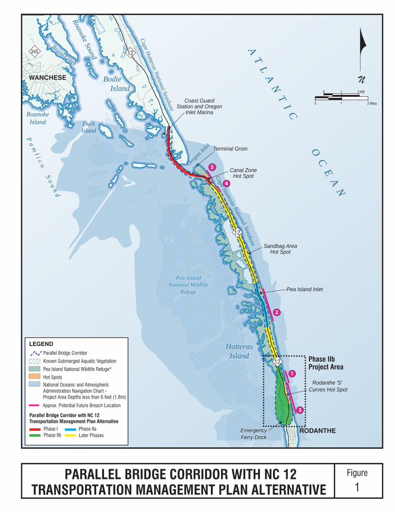
The project area for the Bonner Bridge Replacement Project (B‐2500) is shown in Figure
1, along with the locations of Phases I and II (both IIa and IIb) of the PBC/TMP
Alternative. The Phase IIb (B‐2500B) project area also is shown in Figure 1. The Bonner
Bridge Replacement Project (B‐2500) project area starts at the southern tip of Bodie
Island and extends south to the community of Rodanthe. The boundaries of the project
area were chosen to include the Bonner Bridge over Oregon Inlet, as well as NC 12
between Oregon Inlet and the community of Rodanthe, an area that is at risk because of
shoreline erosion. The Phase IIb project area includes the area between about the
southern end of the 2.1‐mile section of NC 12 in the southern half of the Refuge that is
not expected to be threatened by shoreline erosion prior to 2060 and NC 12’s intersection
with Myrna Peters Road (SR 1492) in Rodanthe. This area includes the Rodanthe breach
that was created by Hurricane Irene in August 2011, as well as the Rodanthe ‘S’ Curves
Hot Spot and two areas identified in the 2008 Final Environmental Impact Statement
(FEIS) as geologically susceptible to breaches (see Figure 1).
1.1 Purpose of the Environmental Assessment
The purpose of this EA for Phase IIb is to identify and assess changes in the setting,
project, and impacts that may have occurred since the 2010 ROD for the PBC/TMP
Alternative was issued on December 20, 2010. This EA for Phase IIb is established on
the previous NEPA documentation for the Bonner Bridge Replacement Project (B‐2500)
as its basis. The previous NEPA documentation includes:
Final Environmental Impact Statement (FEIS) and Section 4(f) Evaluation signed in
September 2008 (2008 FEIS).
Revised Final Section 4(f) Evaluation signed in October 2009.
Environmental Assessment signed in May 2010 (2010 EA).
Rodanthe 'S' Curves Hot Spot
Oregon
Inlet
AT
LA
NT
IC
OC
EA
N
Pa
ml i c
o S
ou
nd
Roanoke Sound
DuckIsland
Cape Hatteras National Seashore
Cape Hatteras National Seashore
Broad Creek
RoanokeIsland
HatterasIsland
Bodie Island
345
RODANTHE
WANCHESE
EmergencyFerry DockEmergencyFerry Dock
HatterasIsland
Coast GuardStation and Oregon
Inlet Marina
Pea IslandNational Wildlife
Refuge
Pea IslandNational Wildlife
Refuge
Canal ZoneHot Spot
Terminal Groin
Sandbag AreaHot Spot
Pea Island Inlet
Parallel Bridge Corridor
N
10
0 1 2 KM
2 Miles
Known Submerged Aquatic Vegetation
Pea Island National Wildlife Refuge*
Hot Spots
LEGEND
National Oceanic and AtmosphericAdministration Navigation Chart - Project Area Depths less than 6 feet (1.8m)
PARALLEL BRIDGE CORRIDOR WITH NC 12TRANSPORTATION MANAGEMENT PLAN ALTERNATIVE
Figure
1
Phase IIaPhase IPhase IIb Later Phases
Parallel Bridge Corridor with NC 12 Transportation Management Plan Alternative
12
12
12
Approx. Potential Future Breach Location
5
4
2
1
3
Phase IIbProject Area

Bonner Bridge Replacement EA NCDOT STIP Project Number B‐2500B
Phase IIb – Rodanthe Breach
1‐4
Record of Decision that selected the PBC/TMP Alternative issued in December 2010
(2010 ROD).
Environmental Assessment for Phase IIa signed in February 2013 (Phase IIa EA).
Record of Decision for Phase IIa issued in October 2013 (Phase IIa ROD).
The findings of these documents are incorporated into this EA by this reference. The
Phase IIa EA and the Phase IIa ROD are available on the compact disc (CD) that
accompanies this EA, at the public review locations listed in Section 6.6, and on the
NCDOT web site at http://www.ncdot.gov/projects/bonnerbridgephase2.
The purpose of this EA also is to provide documentation of compliance with NEPA in
accordance with the PBC/TMP Alternative. The limits of the Phase IIb project area in the
context of the PBC/TMP Alternative are shown in Figure 1. This EA includes the
following:
A description of the Phase IIb alternative screening process, including the steps
followed (including scoping), alternatives considered, screening findings, and
several additional studies conducted in the project area.
A description of the two detailed study alternatives for Phase IIb (Bridge within
Existing NC 12 Easement Alternative and Bridge on New Location Alternative) that
were selected by the project’s NEPA/Section 404 Merger Team for detailed study.
(See Section 6.2 for a description of the Merger Team process and Section 6.2.6 of the
Phase IIa EA for a description of the November 14, 2012 Merger Team meeting at
which these two alternatives were selected.) The decisions at the November 14, 2012
meeting relevant to Phase IIb are described in Section 6.2 of this EA. The
Concurrence Point No. 2 and 2A form for Phase IIb is included in Appendix A of this
EA. The Bridge within Existing NC 12 Easement Alternative is identified as the
Preferred Alternative in this EA.
An update of the assessment of the Phase IIb detailed study alternatives, including a
description of changes in the environmental setting since the release of the 2010
ROD; a description of the impacts of the two detailed study alternatives; a discussion
of costs and financing; and a discussion of the effects that the changes in setting,
Phase IIb impacts, and costs and financing findings have on the Bonner Bridge
Replacement Project (B‐2500) as a whole. Changes in the environmental setting since
the release of the 2010 ROD are primarily associated with on‐going beach erosion
and storm activity, including the formation of the Rodanthe breach during
Hurricane Irene in August 2011 (which was closed by NCDOT during repairs to
NC 12) and on‐going challenges of keeping NC 12 open at the Rodanthe ‘S’ Curves
Hot Spot during storm events.

Bonner Bridge Replacement EA NCDOT STIP Project Number B‐2500B
Phase IIb – Rodanthe Breach
1‐5
An evaluation of the October 2009 Revised Final Section 4(f) Evaluation (Revised 4(f)
Evaluation) that includes: a summary of the findings from the October 2009 Revised
4(f) Evaluation, a brief description of the two proposed detailed study alternatives
for Phase IIb, a description of the three Section 4(f) properties in the Phase IIb project
area, a discussion of the impacts to those Section 4(f) properties (a use or
constructive use would occur at only one of the three properties), an analysis of
avoidance alternatives, the least harm analysis, and all possible planning to
minimize harm.
A summary of public and agency scoping conducted during the consideration of
Phase II, including responses to scoping comments directly associated with Phase
IIb. The public and agency scoping program for Phase II was described in detail in
Chapter 6.0 of the Phase IIa EA. Responses to scoping comments related to Phase IIa
and Phase II in general also were presented in that document. Comments related to
Phase IIb that were raised at the Phase IIa public hearings and during the Phase IIa
comment period also are presented.
An analysis of and preliminary conclusion on the need to prepare a supplemental
Environmental Impact Statement (EIS).
The findings contained within this EA and subsequent review of this EA by the public
and environmental resource and regulatory agencies will be used to determine whether
or not these changes or circumstances would result in significant environmental impacts
in the Phase IIb project area that were not evaluated in the 2008 FEIS, the 2010 EA, and
the 2010 ROD, as well as to finalize a Selected Alternative for Phase IIb. If the agency
conclusion is that these changes or circumstances would result in significant
environmental impacts not evaluated in the previous NEPA documentation, then a
supplemental EIS will be prepared.
FHWA and NCDOT will make this EA available to provide resource agencies and the
public an opportunity to review and comment. Comments received will be reviewed
and taken into account prior either to the determination to prepare a supplemental EIS
or to the approval of a ROD for Phase IIb, which will identify the Selected Alternative
for Phase IIb.
1.2 Description of PBC/TMP Alternative
The PBC/TMP Alternative was identified in the 2010 ROD as the Selected Alternative for
the Bonner Bridge Replacement Project (B‐2500). The PBC/TMP Alternative includes the
replacement of the existing Bonner Bridge with a new Oregon Inlet bridge parallel to
and west of the Bonner Bridge as Phase I of the project, as well as the Phase IIa project
selected in the October Phase IIa ROD. A design‐build contract for Phase I was awarded
in July 2011.
Bonner Bridge Replacement EA NCDOT STIP Project Number B‐2500B
Phase IIb – Rodanthe Breach
1‐6
The PBC/TMP Alternative calls for the study and selection of future actions on Hatteras
Island beyond the limits of Phase I through a comprehensive NC 12 Transportation
Management Plan. The PBC/TMP Alternative includes the following measures
described in Section 3.3.2 of the 2010 ROD beginning on page 12:
NCDOT will fund and implement an on‐going coastal monitoring program on
Hatteras Island within the project study area (i.e., Oregon Inlet to Rodanthe). The
data to be gathered includes the extent and location of geomorphological features,
the relationship of NC 12 to those features, overwash occurrences, NC 12
maintenance data, dredge disposal and beach nourishment projects undertaken, and
storm event data. The results presented in the monitoring program’s annual reports
will be used to determine when planning of future phases of the project should
begin. The program was initiated in early 2011.
NCDOT will fund and implement a periodic Refuge habitat/NC 12 vulnerability
forecasting study in consultation with the US Fish and Wildlife Service (USFWS)
with at least a five‐year recurrence. Through this program, NCDOT and USFWS will
work together to develop and assess alternative future scenarios including possible
site‐specific events and remedies. This program is based on the on‐going findings of
the coastal monitoring program (as discussed in Section 2.6.3 of the Phase IIa EA).
With the current focus on developing for implementation the Phase II projects, the
vulnerability forecasting component of the PBC/TMP Alternative has not yet
formally begun. The coastal monitoring program results to date have, however,
identified potential areas within the Refuge where NC 12 is vulnerable. These areas
likely will be the initial focus of the first vulnerability forecasting study.
NCDOT and FHWA will use the results of the coastal monitoring program and the
periodic Refuge habitat/NC 12 vulnerability forecasting study to determine when the
environmental review for each phase (e.g., Phase III) should be initiated and what
alternative actions should be studied in detail. This assessment will be performed
after the completion of each report prepared as part of the coastal monitoring
program and after each iteration of the vulnerability study. In other words, based on
the measures included in the PBC/TMP Alternative, the conditions in the Bonner
Bridge Replacement Project (B‐2500) project area will be constantly re‐assessed to
determine whether the next project phase should be implemented until the full
PBC/TMP Alternative is completed.
The NEPA/Section 404 Merger Process will be used to study, select, and finalize
future phases. The NEPA/Section 404 Merger Process is described in Section 6.2.

Bonner Bridge Replacement EA NCDOT STIP Project Number B‐2500B
Phase IIb – Rodanthe Breach
2‐1
2.0 Description of Phase IIb Alternatives Analysis
2.1 NC 12 Alternatives Included in the Parallel Bridge Corridor with the PBC/TMP Alternative
The alternatives listed below were previously assessed within the Parallel Bridge
Corridor in the 2008 FEIS and 2010 EA. They are included in the PBC/TMP Alternative
as potential phases beyond Phase I and are representative of the range of potential
impacts of the PBC/TMP Alternative. Section 2.10 of the 2008 FEIS describes these
Parallel Bridge Corridor alternatives in detail. In addition, Section 2.1 of the 2010 EA
describes updates to the designs of several of these alternatives so as to address agency
concerns about impacts to the Rodanthe Historic District. These PBC/TMP Alternatives
are:
Nourishment Alternative – NC 12 would remain in its current location and beach
nourishment (combined with dune enhancement) would be used to maintain an
adequate protective beach and dune system. Nourishment would occur in four
locations, likely repeated at four‐year intervals.
Road North/Bridge South Alternative – NC 12 would be relocated as a road west of
the forecast 2060 high‐erosion shoreline in the north end of the Refuge. At the south
end of the Refuge and in Rodanthe, NC 12 would be placed on a bridge west of
Hatteras Island.
All Bridge Alternative – NC 12 would be relocated onto a bridge west of the forecast
2060 high‐erosion shoreline in the north end of the Refuge. At the south end of the
Refuge and in Rodanthe, NC 12 would be placed on a bridge west of Hatteras Island.
Phased Approach Alternatives – NC 12 would be elevated in its current easement
onto a series of bridges within the Refuge and in Rodanthe. There are two options
for the Phased Approach in Rodanthe. The Phased Approach/Rodanthe
Nourishment Alternative includes a bridge that ends just south of the Refuge
boundary and the use of beach nourishment to stabilize NC 12 in Rodanthe. The
Phased Approach/Rodanthe Bridge Alternative includes a bridge in Rodanthe that
ends just north of the Rodanthe Historic District (no beach nourishment). The
Selected Alternative in Phase IIa, the Bridge within Existing NC 12 Easement
Alternative, elevates NC 12 in its current easement in the area in the Refuge near the
Pea Island inlet.
All of these alternatives remain potential options for future phases, reflecting several
basic approaches to addressing project need, including: addressing the threat to existing

Bonner Bridge Replacement EA NCDOT STIP Project Number B‐2500B
Phase IIb – Rodanthe Breach
2‐2
NC 12 by protecting the road from the natural forces (e.g., ocean overwash and beach
erosion) that create the need for improvements, moving the road west on a road away
from the shoreline affected by current and future erosion, and moving NC 12 to a bridge
either in the existing easement or west away from the shoreline affected by current and
future erosion.
Based on the original alternatives listed above, four alternatives were considered as
possible long‐term improvements for the Phase IIb Rodanthe breach study area. As a
Phase IIb alternative, all four alternatives would extend from within the Refuge south to
the intersection of NC 12 and Myrna Peters Road (SR 1492) in Rodanthe. This distance
includes the Rodanthe ‘S’ Curves Hot Spot and two areas identified in the 2008 FEIS for
this study area as geologically susceptible to breaches (see Figure 1). The four
alternatives considered for study in the Rodanthe breach study area are:
1. Beach Nourishment
2. Bridge on New Location (from Road North/Bridge South and All Bridge
alternatives)
3. Bridge within Existing NC 12 Easement (part of Phase II of Phased
Approach/Rodanthe Bridge Alternative)
4. Bridge within Existing NC 12 Easement and Beach Nourishment (part of Phase II of
Phased Approach/Rodanthe Nourishment Alternative)
In the remainder of this EA for Phase IIb, these alternatives will be identified by their
Phase IIb descriptive names above rather that the names used in previous
environmental documentation. These four alternatives, which were assessed in the 2008
FEIS and 2010 EA, are illustrated in Figure 2.
This Phase IIb EA does not address alternatives to the PBC/TMP Alternative that were
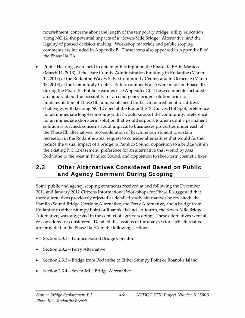
suggested during scoping for Phase II (i.e., the Pamlico Sound Bridge Corridor, the Ferry
Alternative, a bridge from Rodanthe to either Stumpy Point or Roanoke Island, and the
Seven‐Mile Bridge Alternative). Section 2.3 of the Phase IIa EA describes these
alternatives and the reasons each was not studied in detail in Phase II. Appendix C of
the Phase IIa ROD responds to additional comments advocating these alternatives that
were received during the public review process for the Phase IIa EA. Consideration of
these comments did not result in a change in the decision not to study these alternatives
in detail for Phase II.
2.2 Scoping
Scoping activities completed as part of Phase II included an October 18, 2011 Merger
Team meeting, an October 2011 Peer Exchange meeting, and three Citizens

APPROXIMATE SCALE IN MILES
0.500 0.25
Refuge Boundary
ChicamacomicoLife Saving
Station
EmergencyFerry Dock
LibertyServiceStation
Auto RepairBusiness
ChicamacomicoLife Saving
Station
RodantheHistoric District
RodantheHistoric District
Trailer Park
Dare County WaterTreatment Plant
Trailer Park
Cemetery
RODANTHE
A T L A N T I C O C E A N
Pea Island National Wildlife Refuge
1212
BRIDGE ON NEW LOCATION
P a m l i c o S o u n d
Sea Haven Dr
Laura Ln
Surfside Dr
Sea Oats Dr
America Dr
SR 1516 (E. Point Dr)
E. Beacon Dr
Pappy Ln
Banzai Landing
Wimble Shoals Dr
Corbina Dr
Midgett Dr
SR 1492(Myrna Peters Rd) SR 1445 (Cross o
f Honor Way)
END OF BRIDGE WITHIN EXISTING NC 12 EASEMENT
END OF BRIDGE WITHIN EXISTING NC 12 EASEMENTAND BEACH NOURISHMENT
BEACH NOURISHMENT AREA
BEACH NOURISHMENT AREA
NEW 20 FT HIGH DUNENEW 20 FT HIGH DUNE
Aerial date: April 13, 2013
Bridge on New Location
Bridge within ExistingNC 12 Easement
Bridge within Existing NC 12 Easement and Beach Nourishment
Beach Nourishment
PHASE IIb ALTERNATIVES CONSIDEREDFigure
2

Bonner Bridge Replacement EA NCDOT STIP Project Number B‐2500B
Phase IIb – Rodanthe Breach
2‐4
Informational Workshops:
The October 18, 2011 Merger Team meeting was an informational/scoping meeting.
The purposes of the meeting were for NCDOT to inform the Merger Team members
about the initiation of Phase II following Hurricane Irene, as well as to allow agency
representatives to provide scoping comments on impact issues and alternatives
related to the two breach sites (i.e., Pea Island inlet and Rodanthe). The action items
identified at the meeting were to: further address the merits of a Ferry Alternative
(see Section 2.3.2 of the Phase IIa EA), consult with the National Marine Fisheries
Service (NMFS) under Section 7 of the Endangered Species Act (ESA) of 1973
regarding the Atlantic sturgeon (see Sections 4.1.4 and 4.2.4.4 of the Phase IIa EA and
Section 4.1.6 and 4.2.5.4 of this EA), revisit the cost and financing of a bridge in the
Pamlico Sound Bridge Corridor (see Section 2.6.1 of the Phase IIa EA), and consider a
“Seven‐Mile Bridge Alternative” (see Section 2.3.4 of the Phase IIa EA). This meeting
is described in Section 6.2.2 of the Phase IIa EA.
The purposes of the October 24 and 25, 2011 Peer Exchange meeting were to get
feedback from a panel of coastal scientists and engineers on the four Parallel Bridge
Corridor alternatives under consideration for the Phase IIa and IIb project areas, as
well as to get their suggestions on other potential alternatives for consideration (see
Section 2.6.2 of the Phase IIa EA for a summary of the Peer Exchange meeting). In
response to this request, the USFWS‐Refuge representative suggested a “Seven‐Mile
Bridge Alternative” as a possible additional option. The USFWS‐Refuge
representative also mentioned this option at the October 18, 2011 Merger Team
meeting. Section 2.3.4 of the Phase IIa EA presents a detailed discussion of the
Seven‐Mile Bridge Alternative, including the additional coordination that took place
with USFWS‐Refuge related to this alternative).
Citizens Informational Workshops were held in Manteo (December 5, 2011) at the
Dare County Administration Building, in Rodanthe (December 6, 2011) at the
Rodanthe‐Waves‐Salvo Community Center, and in Ocracoke (January 5, 2012) at the
Community Center. The purposes of the three workshops were to provide the
public with an opportunity to review and revisit the alternatives considered in the
2008 FEIS and the 2010 EA, to consider their potential implementation at the two
breach sites, and to suggest other alternatives that might be considered.
Environmental issues also were discussed. These workshops are described in
Section 6.1.1 of the Phase IIa EA. Scoping comments were made related to project
need and timing, reconsideration of the Pamlico Sound Bridge Corridor,
reconsideration of a Ferry Alternative, consideration of bridges to Rodanthe
originating at either Stumpy Point or Roanoke Island, potential impacts and merits
of relocating NC 12 on a bridge either in a new NC 12 easement (within the Refuge
or Pamlico Sound) or in the existing easement, potential impacts and merits of
relocating NC 12 as a surface road, potential impacts and merits of beach
Bonner Bridge Replacement EA NCDOT STIP Project Number B‐2500B
Phase IIb – Rodanthe Breach
2‐5
nourishment, concerns about the length of the temporary bridge, utility relocation
along NC 12, the potential impacts of a “Seven‐Mile Bridge” Alternative, and the
legality of phased decision‐making. Workshop materials and public scoping
comments are included in Appendix B. These items also appeared in Appendix B of
the Phase IIa EA.
Public Hearings were held to obtain public input on the Phase IIa EA in Manteo
(March 11, 2013) at the Dare County Administration Building, in Rodanthe (March
12, 2013) at the Rodanthe‐Waves‐Salvo Community Center, and in Ocracoke (March
13, 2013) at the Community Center. Public comments also were made on Phase IIb
during the Phase IIa Public Hearings (see Appendix C). These comments included:
an inquiry about the possibility for an emergency bridge solution prior to
implementation of Phase IIb, immediate need for beach nourishment to address
challenges with keeping NC 12 open at the Rodanthe ‘S’ Curves Hot Spot, preference
for an immediate long‐term solution that would support the community, preference
for an immediate short‐term solution that would support tourism until a permanent
solution is reached, concerns about impacts to businesses properties under each of
the Phase IIb alternatives, reconsideration of beach renourishment to sustain
recreation in the Rodanthe area, request to consider alternatives that would further
reduce the visual impact of a bridge in Pamlico Sound, opposition to a bridge within
the existing NC 12 easement, preference for an alternative that would bypass
Rodanthe to the west in Pamlico Sound, and opposition to short‐term cosmetic fixes.
2.3 Other Alternatives Considered Based on Public and Agency Comment During Scoping
Some public and agency scoping comments received at and following the December
2011 and January 2012 Citizens Informational Workshops for Phase II suggested that
three alternatives previously rejected as detailed study alternatives be revisited: the
Pamlico Sound Bridge Corridor Alternative, the Ferry Alternative, and a bridge from
Rodanthe to either Stumpy Point or Roanoke Island. A fourth, the Seven‐Mile Bridge
Alternative, was suggested in the context of agency scoping. These alternatives were all
re‐considered or considered. Detailed discussions of the analyses for each alternative
are provided in the Phase IIa EA in the following sections:
Section 2.3.1 – Pamlico Sound Bridge Corridor
Section 2.3.2 – Ferry Alternative
Section 2.3.3 – Bridge from Rodanthe to Either Stumpy Point or Roanoke Island
Section 2.3.4 – Seven‐Mile Bridge Alternative

Bonner Bridge Replacement EA NCDOT STIP Project Number B‐2500B
Phase IIb – Rodanthe Breach
2‐6
The conclusion was reached that all four alternatives are unreasonable because they do
not meet the project purpose and need, are not affordable, and/or because of potential
environmental impacts. Appendix C of the Phase IIa ROD responds to additional
comments advocating the first three alternatives that were received during the public
and agency review process for the Phase IIa EA. The responses to those comments re‐
affirmed the reasons each was not a reasonable alternative.
2.4 Phase IIb Detailed Study Alternatives (Bridge on New Location and Bridge within Existing NC 12 Easement)
2.4.1 Detailed Study Alternative Selection
At the November 14, 2012 Merger Team meeting, the Team reached consensus that,
from among the alternatives described in the previous sections, the Bridge on New
Location and the Bridge within Existing NC 12 Easement alternatives (see Figure 3)
would be carried forward as the detailed study alternatives for Phase IIb. FHWA,
NCDOT, US Army Corps of Engineers (USACE), the North Carolina Department of
Environment and Natural Resources (NCDENR)‐Division of Water Quality (DWQ)
(now within NCDENR‐Division of Water Resources [DWR]), the North Carolina
Department of Cultural Resources (NCDCR), and NCDENR‐Division of Coastal
Management (DCM) signed the Merger Team concurrence forms. USEPA, USFWS,
USFWS‐Refuge, NMFS, the National Park Service (NPS), NCDENR‐Division of Marine
Fisheries (DMF), and the North Carolina Wildlife Resources Commission (NCWRC)
abstained (see Section 6.2 for the Merger Process definition of abstention). The
concurrence form is included in Appendix A of this Phase IIb EA.
The Phase IIb detailed study alternatives would involve building a bridge on new
location (part of Road North/Bridge South Alternative) or building a bridge in the
existing NC 12 easement (portion of Phase II of Phased Approach/Rodanthe Bridge
Alternative).
The Bridge on New Location Alternative, including the bridge and its associated
roadway approaches, is approximately 3.0 miles in length. The bridge portion of this
alternative is approximately 2.6 miles in length. The reasons the Bridge on New
Location Alternative was selected as a detailed study alternative are: it would avoid the
entire area considered geologically susceptible to breaches in the Phase IIb project area
(see Figure 3) and it would be less vulnerable to potential future changes in Hatteras
Island resulting from shoreline erosion than the Bridge within Existing NC 12 Easement
Alternative. Finally, it would remove the NC 12 transportation corridor from a portion
of the Refuge, allowing natural coastal processes to resume in that portion of the Refuge,
which is consistent with current Refuge management policy.

APPROXIMATE SCALE IN MILES
0.500 0.25
Refuge Boundary
ChicamacomicoLife Saving
Station
EmergencyFerry Dock
LibertyServiceStation
Auto RepairBusiness
ChicamacomicoLife Saving
Station
RodantheHistoric District
RodantheHistoric District
Trailer Park
Dare County WaterTreatment Plant
Trailer Park
Cemetery
RODANTHE
A T L A N T I C O C E A N
Pea Island National Wildlife Refuge
1212
BRIDGE ON NEW LOCATION
BRIDGE WITHIN EXISTING NC 12 EASEMENT
P a m l i c o S o u n d
Sea Haven Dr
Laura Ln
Surfside Dr
Sea Oats Dr
America Dr
SR 1516 (E. Point Dr)
E. Beacon Dr
Pappy Ln
Banzai Landing
Wimble Shoals Dr
Corbina Dr
Midgett Dr
SR 1492(Myrna Peters Rd) SR 1445 (Cross o
f Honor Way)
Bridge on New Location
Bridge within ExistingNC 12 Easement
Aerial date: April 13, 2013
PHASE IIb DETAILED STUDY ALTERNATIVESFigure
3

Bonner Bridge Replacement EA NCDOT STIP Project Number B‐2500B
Phase IIb – Rodanthe Breach
2‐8
The Bridge within Existing NC 12 Easement Alternative is approximately 2.5 miles in
length, including the roadway approaches to the bridge. The bridge portion of this
alternative is approximately 2.3 miles in length. The reasons the Bridge within Existing
NC 12 Easement Alternative was selected as a detailed study alternative are that it
would bridge over the entire area considered geologically susceptible to breaches in the
Phase IIb project area (see Figure 3) and it would not require a change in the existing
NC 12 easement within the Refuge.
The Phase IIb detailed study alternatives are described further in Chapter 3.0, and
potential impacts are discussed in Section 4.2. The remaining alternatives discussed in
Section 2.1 and the reasons that each was eliminated from further consideration are:
Beach Nourishment – This alternative was eliminated because of uncertainties
related to the availability of a suitable sand source over the project’s estimated 50‐
year life (i.e., through 2060); it would not adequately protect NC 12 from potential
future breaches/ inlets (either from the ocean or sound‐side [such as Hurricane Irene]
storm surges, although the dunes associated with this alternative would reduce the
risk of a breach occurring in this area since NC 12 would remain at‐grade; it would
not allow natural island processes to occur; and, based on the opinions of USFWS
representatives, it is not likely to be found compatible with the Refuge’s mission and
purpose. It also was a recommendation of the October 2011 Peer Exchange coastal
expert panel that a long‐term beach nourishment program not be implemented in
the Phase IIb project area because of the high rate of shoreline erosion in this area
(See Section 2.6.1).
Bridge within Existing NC 12 Easement and Beach Nourishment – This alternative
was eliminated because its nourishment component presented concerns similar to
the Beach Nourishment Alternative. The primary difference is that although the
availability of a suitable sand source is a concern, this alternative would require less
sand over the project’s estimated 50‐year life (i.e., through 2060) than the Beach
Nourishment (only) alternative, because a smaller area of beach would be nourished.
2.4.2 Development of Phase IIb Preliminary Design for Bridge on New Location Alternative
The preliminary design for the Bridge on New Location Alternative assessed in this EA
incorporates two changes from the Bridge South component of the Road North/Bridge
South Alternative that was assessed in the 2010 EA. First, the northern end was refined
in consultation with Refuge representatives to identify an alignment that minimized the
use of new Refuge lands while conforming to NCDOT design standards. The alignment
assessed in this EA would require 2.79 acres of new easement in the Refuge. The
alternative is designed to be entirely on structure when it leaves the existing NC 12
easement so that the direct impact to Refuge habitat would be limited to bridge piles
and shading from the bridge deck. Second, because in order for the alternative to

Bonner Bridge Replacement EA NCDOT STIP Project Number B‐2500B
Phase IIb – Rodanthe Breach
2‐9
continue to meet horizontal curve design speed requirements after the first change, the
alignment was further shifted approximately 930 to 950 feet further to the west in
Pamlico Sound. (See Figure 4.) The Bridge on New Location Alternative both begins
and terminates more than 230 feet soundward of the 2060 high erosion shoreline forecast
in 2012, NCDOT’s preferred criterion for minimizing the potential for impacts from
shoreline erosion prior to 2060.
2.4.3 Development of Phase IIb Preliminary Design for Bridge within Existing NC 12 Easement Alternative
The preliminary design for the Bridge within Existing NC 12 Easement Alternative
assessed in this EA incorporates three refinements from the Phased Approach/Rodanthe
Bridge Alternative assessed in the 2008 FEIS and 2010 EA. One design refinement is
within the Refuge, while the other two are in Rodanthe.
Within the Refuge, the bridge is lower in height. The additional site analysis performed
for necessary bridge heights by NCDOT for the Phase IIa project area applies to Phase
IIb in the Refuge (see Section 4.2.1 of the Phase IIa EA on page 4‐16). This analysis was
done in coordination with members of the committee who originally developed
Hurricane Katrina storm surge safety requirements. Based on the results of this
analysis, it was determined that it would be sufficient for the Phase IIb bridge to have
15.8 feet of clearance between mean high water and the bottom of the superstructure,
instead of 25 feet. In addition, the deck would be at 25 feet above mean sea level instead
of 33.5 feet.
Within Rodanthe, the bridge also is lower in height but not as low as in the Refuge. In
Rodanthe, motor vehicles operating on the one‐way frontage roads parallel to the bridge
need to make u‐turns under the bridge (see Figure 5 in Section 3.2 below). The frontage
roads would be provided to maintain access to private property on either side of NC 12.
The bridge clearance in Rodanthe needs to be high enough to accommodate large trucks
that might need to make a u‐turn under the bridge. In Rodanthe, the Phase IIb bridge
would have a minimum of 17 feet of clearance for motor vehicle traffic (between the
ground and the bottom of the superstructure). The deck would be 30 feet above mean
sea level instead of the 33.5 feet in the earlier design.
Also within Rodanthe, the design assessed in the 2010 EA ended the main (33.5‐foot‐
high) bridge at a point approximately 680 feet north of Myra Peters Road (SR 1492). The
design assessed in the 2010 EA avoided adverse impacts to the Chicamacomico Life
Saving Station and Rodanthe Historic District, but did not achieve the project goal of
placing the end of the main bridge 230 feet soundward of the forecast 2060 high‐erosion
shoreline used for the 2008 FEIS and 2010 EA. Under the 2010 design, the main bridge

APPROXIMATE SCALE IN MILES
0.500 0.25
Refuge Boundary
ChicamacomicoLife Saving
Station
EmergencyFerry Dock
LibertyServiceStation
Auto RepairBusiness
ChicamacomicoLife Saving
Station
RodantheHistoric District
RodantheHistoric District
Trailer Park
Dare County WaterTreatment Plant
Trailer Park
Cemetery
RODANTHE
A T L A N T I C O C E A N
Pea Island National Wildlife Refuge
1212
2013 BRIDGE ON NEW LOCATION
2010 “BRIDGE SOUTH” P a m l i c o S o u n d
Sea Haven Dr
Laura Ln
Surfside Dr
Sea Oats Dr
America Dr
SR 1516 (E. Point Dr)
E. Beacon Dr
Pappy Ln
Banzai Landing
Wimble Shoals Dr
Corbina Dr
Midgett Dr
SR 1492(Myrna Peters Rd) SR 1445 (Cross o
f Honor Way)
2013 Bridge on New Location Alternative
2010 “Bridge South” (2010 EA)
Aerial date: April 13, 2013
COMPARISON OF BRIDGE ON NEW LOCATION ALTERNATIVE AND “BRIDGE SOUTH” FROM 2010 EA
Figure
4

Bonner Bridge Replacement EA NCDOT STIP Project Number B‐2500B
Phase IIb – Rodanthe Breach
2‐11
ended approximately 250 feet seaward of the forecast 2060 high erosion shoreline
(between the forecast 2040 and 2050 high erosion shorelines). A slip ramp (ramp on the
sound side of and parallel to the main bridge) was used to bring traffic down to the
ground level before NC 12 reaches the historic district. The intent was that if high
erosion rates manifested themselves, or a breach occurred that put the slip ramp‐to‐
grade at risk, then, following additional environmental analysis, a new ramp could be
built off the end of the full height bridge and/or the full height bridge could be extended.
In terms of impacts to the Chicamacomico Life Saving Station and Rodanthe Historic
District, the then‐forecast 2060 high erosion shoreline placed almost all of the
Chicamacomico Life Saving Station and approximately half of the Rodanthe Historic
District in the Atlantic Ocean. FHWA and NCDOT planned to reassess the condition of
these historic resources prior to the implementation of any extension of this alternative
southward in response to shoreline erosion.
As shown in Figure D‐1 in Appendix D, the erosion in the Rodanthe area through 2060 is
now forecast to be less than was forecast for the 2008 FEIS and 2010 EA. This provides
an opportunity to alter the south end of the Bridge within Existing NC 12 Easement
Alternative to eliminate the slip ramp and bring the bridge down to grade before the
Rodanthe Historic District. This design reduces the community impacts that had
resulted from the wider NC 12 right‐of‐way needed to accommodate both the main
bridge and the slip ramp. In Rodanthe, the revised main bridge ends approximately 140
feet west of the 2060 high erosion shoreline forecast using data through 2012. The
approach bridge and fill then extend from the end of the main bridge. The revised
design also does not meet the original goal of placing the end of the main bridge 230 feet
soundward of the forecast 2060 high‐erosion shoreline, but it offers a reasonable balance
for this alternative between that goal and the objective of minimizing impacts to the
Chicamacomico Life Saving Station, and the Rodanthe Historic District. The northern
end of this alternative is more than 230 feet soundward of the forecast 2060 high erosion
shoreline.
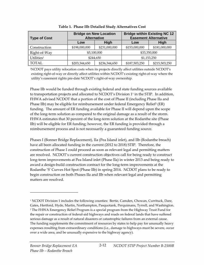
2.5 Phase IIb Detailed Study Alternatives Cost and Financing
Based on the revised designs, NCDOT updated the construction cost estimates for the
Phase IIb detailed study alternatives. Consistent with the cost estimates included in the
2008 FEIS, a “low” and “high” construction cost estimate was prepared to reflect a range
of possible structure types and construction techniques. These estimates are shown in
Table 1 and are subject to change as the final design is developed.
Bonner Bridge Replacement EA NCDOT STIP Project Number B‐2500B
Phase IIb – Rodanthe Breach
2‐12
Table 1. Phase IIb Detailed Study Alternatives Cost
Type of Cost Bridge on New Location
Alternative Bridge within Existing NC 12
Easement Alternative Low High Low High
Construction $198,000,000 $231,000,000 $153,000,000 $181,000,000
Right‐of‐Way $5,100,000 $33,350,000
Utilities1 $244,650 $1,153,250
TOTAL $203,344,650 $236,344,650 $187,503,250 $215,503,250
1NCDOT pays utility relocation costs when its projects directly affect utilities outside NCDOT’s
existing right‐of‐way or directly affect utilities within NCDOT’s existing right‐of‐way where the
utility’s easement rights pre‐date NCDOT’s right‐of‐way ownership.
Phase IIb would be funded through existing federal and state funding sources available
to transportation projects and allocated to NCDOT’s Division 11 in the STIP. In addition,
FHWA advised NCDOT that a portion of the cost of Phase II (including Phase IIa and
Phase IIb) may be eligible for reimbursement under federal Emergency Relief2 (ER)
funding. The amount of ER funding available for Phase II will depend upon the scope
of the long‐term solution as compared to the original damage as a result of the storm.
FHWA estimates that 30 percent of the long‐term solution at the Rodanthe site (Phase
IIb) will be eligible for ER funding; however, the ER funding is provided through a
reimbursement process and is not necessarily a guaranteed funding source.
Phases I (Bonner Bridge Replacement), IIa (Pea Island inlet), and IIb (Rodanthe breach)
have all been allocated funding in the current (2012 to 2018) STIP. Therefore, the
construction of Phase I could proceed as soon as relevant legal and permitting matters
are resolved. NCDOT’s current construction objectives call for being ready to construct
long‐term improvements at Pea Island inlet (Phase IIa) in winter 2013 and being ready to
award a design‐build construction contract for the long‐term improvements at the
Rodanthe ‘S’ Curves Hot Spot (Phase IIb) in spring 2014. NCDOT plans to be ready to
begin construction on both Phases IIa and IIb when relevant legal and permitting
matters are resolved.
1 NCDOT Division 1 includes the following counties: Bertie, Camden, Chowan, Currituck, Dare,
Gates, Hertford, Hyde, Martin, Northampton, Pasquotank, Perquimans, Tyrrell, and Washington. 2 The FHWA Emergency Relief Program is a special program from the Highway Trust Fund for
the repair or construction of federal‐aid highways and roads on federal lands that have suffered
serious damage as a result of natural disasters or catastrophic failures from an external cause.
The funding supplements the commitment of resources by states to help pay for unusually heavy
expenses resulting from extraordinary conditions (i.e., damage to highways must be severe, occur
over a wide area, and be unusually expensive to the highway agency).

Bonner Bridge Replacement EA NCDOT STIP Project Number B‐2500B
Phase IIb – Rodanthe Breach
2‐13
2.6 New Studies
2.6.1 Phase II New Studies Presented in the Phase IIa EA
The Phase IIa EA documented the following four new studies associated with Phase II:
New Cost Estimates for the Pamlico Sound Bridge Corridor are presented in Section
2.3.1 (beginning on page 2‐5).
Peer Exchange Meeting held in October 2011 to discuss the impacts of Hurricane
Irene as well as engineering and scientific concerns over proposed long‐term options
for NC 12; a summary of the meeting discussions and main conclusions related to
Phase IIa are presented in Section 2.6.2 (beginning on page 2‐29). Findings
pertaining to Phase IIb are:
The Panel agreed that the two breaches resulting from Hurricane Irene were not
caused by a storm surge from the ocean side, but rather from the sound side.
Also, they agreed that the storm surge flooded man‐made ditches to the west of
the Rodanthe breach location and continued to the ocean to create the Rodanthe
breach.
The Panel noted that because of the high shoreline erosion rate in the Phase IIb
project area, a bridge within the existing NC 12 easement would ultimately result
in the structure being in the ocean a notable distance from shore, as compared to
other locations where this alternative might be used. Thus, the Panel agreed that
from this perspective, the Bridge within Existing NC 12 Easement Alternative
would be not the best long‐term solution at the Rodanthe breach site.
The Panel agreed that from a coastal engineering perspective, placing NC 12 on a
bridge in Pamlico Sound (Bridge on New Location Alternative) would be a better
option than the Bridge within Existing NC 12 Easement Alternative because it
would be less vulnerable to potential future changes in Hatteras Island resulting
from shoreline erosion and breach formation.
The Panel recommended that beach nourishment should not be used as a long‐
term solution at the Rodanthe breach site because it would not address the area’s
susceptibility to inlet formation and because of the area’s high rate of shoreline
erosion.
The Panel indicated that the Bridge on New Location Alternative should be
considered, but the Panel acknowledged that impacts to the Refuge, wetlands,
and homes within Rodanthe are concerns with that alternative.
Updated 2060 Shoreline Forecast and Other Coastal Conditions Updates are
presented in Section 2.6.3 (beginning on page 2‐32). The 2060 high erosion forecast

Bonner Bridge Replacement EA NCDOT STIP Project Number B‐2500B
Phase IIb – Rodanthe Breach
2‐14
completed in 2011 as compared to the shoreline forecast used with the 2008 FEIS is
presented in Appendix D of the Phase IIa EA for the project area from Oregon Inlet
to Rodanthe. A new shoreline forecast adding 2012 erosion data was completed in
2013 and is illustrated in Appendix D of this EA along with the two previous
forecasts. Where forecast lines overlap, the most recent is shown. The biggest
change from the 2011 forecast is in Rodanthe where the 2060 high erosion shoreline
is approximately 40 to 80 feet further east.
Bird survey results are presented in Section 2.6.4 (beginning on page 2‐33).
2.6.2 Ongoing and Additional Phase II New Studies
2.6.2.1 On‐Going Bird Surveys
Semimonthly (twice a month) bird surveys conducted by NCDOT began in October 2011
to record shorebird utilization of the new habitat created by the formation of the Pea
Island inlet. Beginning in 2013, the monthly bird surveys included the entire length of
the Refuge and the Bodie Island spit on the north side of Oregon Inlet until that area was
closed for nesting birds. According to NPS data, four American oystercatcher nests
were in the spit closure, but no piping plover or black skimmer nests were found.
Piping plovers were observed at the spit area and in the area behind the (former) US
Coast Guard station on the south side of Oregon Inlet beginning in March 2013. As
many as seven piping plovers were observed at one time in the area behind the (former)
US Coast Guard station. American oystercatchers, black skimmers and least terns were
observed nesting in this area.
As of July 2013, there were five nesting closures on the Refuge’s beach between Oregon
Inlet and Rodanthe; most were for least terns, but at least one was for American
oystercatcher. NCDOT staff observed two American oystercatcher chicks in this closure
on June 20, 2013. Also on this date, at least 53 least terns were observed inside the
closures. Three nesting closures were south of the Pea Island Inlet area in the Phase IIb
project area, including one for an American oystercatcher nest and two (one east of
NC 12 and one west of NC 12) for primarily least terns (personal communication Dennis
Stewart, USFWS, refuge biologist, 17 September 2013).
In July, August, and September of 2013, NCDOT biologists observed four piping plovers
foraging in the area around the temporary bridge at Pea Island inlet (Phase IIa area). As
of the end of September 2013, no piping plovers have been observed in the Phase IIb
project area by NCDOT biologists. Since the Pea Island inlet closed in May 2013, the
area near the sound has become a location where many other birds rest and forage.
These include greater yellowlegs, great egrets, snowy egrets, great blue and tricolored
herons, white ibis, and black skimmers.

Bonner Bridge Replacement EA NCDOT STIP Project Number B‐2500B
Phase IIb – Rodanthe Breach
2‐15
2.6.2.2 USACE Rodanthe ‘S’ Curve Interim Maintenance Environmental Assessment
USACE was contracted by NCDOT to develop and conduct a one‐time beach
nourishment project that would be designed to help reduce the impact of storms on
NC 12 at the Rodanthe ‘S’ Curves Hot Spot for approximately three years. This project
is a maintenance activity and is not a part of the Bonner Bridge Replacement Project
(B‐2500), but this project is within the Phase IIb project area. A public notice was posted
on July 1, 2013 at http://www.saw.usace.army.mil/Missions/ RegulatoryPermitProgram
/PublicNotices/tabid/10057/Article/15690/saw‐2013‐01129.aspx. USACE approved the
EA for the project on October 15, 2013. USACE concluded that the project would have
no significant impacts.
Two alternatives to the nourishment program were considered:
Maintain NC 12 on its existing alignment with protective sandbags and dunes within
the existing NCDOT easement.
Install a temporary bridge west of the existing easement within the Pea Island
National Wildlife Refuge.
Nourishment was found to be the preferred alternative. To complete the project with
the preferred nourishment alternative, USACE estimates that 1.7 million cubic yards of
material would be needed. After investigating sand sources within Oregon Inlet and
offshore at Wimble Shoals, USACE identified sand sources within Wimble Shoals as
appropriate for the project.
Sand placement would be accomplished by means of hydraulic dredging, including
hopper and/or cutterhead suction dredging. The discharge pipe would be floated from
a seaward station to the nourishment project area beach face where heavy equipment
(e.g., bulldozers, front end loaders) would move and grade the discharged sand into the
desired beach profile. The project is estimated to be completed within 60 to 90 days
from initiation and is projected to begin no earlier than November 2013. The work
would be conducted 24 hours throughout a seven day work week.
The beach nourishment project design focuses the majority of the sand berm placement
within an 8,000 linear foot area located around the Rodanthe ‘S’ Curves Hot Spot/Mirlo
Beach area. The final beach width berm throughout the 8,000 foot critical zone would be
130 feet. North and south of this critical zone, the project would begin transitioning
with a tapered berm back to the existing shoreline. The northern transition zone would
include dune construction that is approximately 1,800 feet long. The total length of the
project, including the critical zone and transition areas, would be approximately 11,300
feet.
The sand utilized for this the beach nourishment project would come from an approved
borrow source that is currently being sampled for compatibility with the native beach

Bonner Bridge Replacement EA NCDOT STIP Project Number B‐2500B
Phase IIb – Rodanthe Breach
2‐16
sand in the project area. The proposed beach nourishment project would only utilize
borrow sand that meets federal and state compatibility requirements.
NCDOT has coordinated with NMFS and NCDENR‐DMF for consultation on impact
minimization. Essential fish habitat (EFH) consultation requirements under the
Magnuson‐Stevens Fishery Conservation and Management Act have been initiated.
USACE has determined that the proposed project would not affect historic resources
present in the proposed beach nourishment area. USACE has determined that the
effects determination for the proposed project is May Affect, Not Likely to Adversely
Affect federally listed endangered or threatened species or their formally designated
critical habitat. USACE has initiated consultation under Section 7 of the Endangered
Species Act.
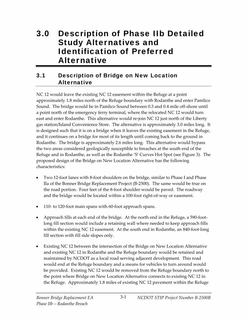
Bonner Bridge Replacement EA NCDOT STIP Project Number B‐2500B
Phase IIb – Rodanthe Breach
3‐1
3.0 Description of Phase IIb Detailed Study Alternatives and Identification of Preferred Alternative
3.1 Description of Bridge on New Location Alternative
NC 12 would leave the existing NC 12 easement within the Refuge at a point
approximately 1.8 miles north of the Refuge boundary with Rodanthe and enter Pamlico
Sound. The bridge would be in Pamlico Sound between 0.3 and 0.4 mile off‐shore until
a point north of the emergency ferry terminal, where the relocated NC 12 would turn
east and enter Rodanthe. This alternative would re‐join NC 12 just north of the Liberty
gas station/Island Convenience Store. The alternative is approximately 3.0 miles long. It
is designed such that it is on a bridge when it leaves the existing easement in the Refuge,
and it continues on a bridge for most of its length until coming back to the ground in
Rodanthe. The bridge is approximately 2.6 miles long. This alternative would bypass
the two areas considered geologically susceptible to breaches at the south end of the
Refuge and in Rodanthe, as well as the Rodanthe ‘S’ Curves Hot Spot (see Figure 3). The
proposed design of the Bridge on New Location Alternative has the following
characteristics:
Two 12‐foot lanes with 8‐foot shoulders on the bridge, similar to Phase I and Phase
IIa of the Bonner Bridge Replacement Project (B‐2500). The same would be true on
the road portion. Four feet of the 8‐foot shoulder would be paved. The roadway
and the bridge would be located within a 100‐foot right‐of‐way or easement.
110‐ to 120‐foot main spans with 60‐foot approach spans.
Approach fills at each end of the bridge. At the north end in the Refuge, a 590‐foot‐
long fill section would include a retaining wall where needed to keep approach fills
within the existing NC 12 easement. At the south end in Rodanthe, an 840‐foot‐long
fill section with fill side slopes only.
Existing NC 12 between the intersection of the Bridge on New Location Alternative
and existing NC 12 in Rodanthe and the Refuge boundary would be retained and
maintained by NCDOT as a local road serving adjacent development. This road
would end at the Refuge boundary and a means for vehicles to turn around would
be provided. Existing NC 12 would be removed from the Refuge boundary north to
the point where Bridge on New Location Alternative connects to existing NC 12 in
the Refuge. Approximately 1.8 miles of existing NC 12 pavement within the Refuge

Bonner Bridge Replacement EA NCDOT STIP Project Number B‐2500B
Phase IIb – Rodanthe Breach
3‐2
would be removed and that portion of the transportation easement would be
returned to the Refuge.
Pile foundations with a pile cap supporting the spans between the foundations.
There would be 15.8 feet of clearance under most of the bridge spans above mean
high water (17 feet from zero elevation), as with Phase IIa. The bridge deck would
be at an elevation of approximately 25 feet.
Bicycle safe bridge rail.
Runoff would be collected from the ends of the Phase IIb bridge and piped to a
riprap apron, which would drain to roadside swales to promote infiltration. Bridge
drainage for the main bridge spans would be from deck drains (openings) at the
outer edges of the deck. The bridge would be high enough to allow wind to disperse
the deck drain discharge before it reaches the ground or inlet surface. Roadway
runoff would drain into roadside ditches.
Construction activity would be primarily confined to the existing or new
easement/right‐of‐way except at the northern end (in the Refuge), where a
temporary construction easement would be needed for a temporary traffic
maintenance road to take traffic around the bridge approach. This temporary
easement would be approximately 0.63 acre in size.
Construction is anticipated to last between 3 and 3.5 years.
3.2 Description of Bridge within Existing NC 12 Easement Alternative
The Bridge within Existing NC 12 Easement Alternative (see Figure 3), would involve
building a bridge in the existing NC 12 easement to replace the existing surface road.
The total length of this alternative is approximately 2.5 miles. The bridge component,
approximately 2.3 miles in length, would bridge two areas considered geologically
susceptible to breaches at the south end of the Refuge and in Rodanthe, as well as the
Rodanthe ‘S’ Curves Hot Spot (see Figure 3). This alternative starts approximately 1.7
miles north of the Refuge boundary with Rodanthe. It continues to the south and ends
at a point on NC 12 approximately 170 feet north of Myrna Peters Road (SR 1492). The
Bridge within Existing NC 12 Easement Alternative has the following characteristics:
Two 12‐foot lanes with 8‐foot shoulders on the bridge, similar to Phase I and Phase
IIa of the Bonner Bridge Replacement Project (B‐2500 and B‐2500A).
Located on the ocean side of the NC 12 easement.

Bonner Bridge Replacement EA NCDOT STIP Project Number B‐2500B
Phase IIb – Rodanthe Breach
3‐3
110‐ to 120‐foot main spans with 60‐foot approach spans.
Approach fills at each end of the bridge (including an approximately 360‐foot‐long
fill section at the south end of the bridge and a 410‐foot‐long fill section at the north
end) with the fill held by a retaining wall where needed to keep approach fills within
the NC 12 easement/right‐of‐way.
Access to properties adjacent to the bridge in Rodanthe would be provided by a one‐
lane, one‐way frontage road on each side of the NC 12 bridge. The two frontage
roads would flare out and connect with NC 12 at a four‐legged intersection at the
south of the end of the project. Crossovers to provide access between the two
frontage roads underneath the NC 12 bridge were assumed to be provided in two
locations: just south of the Refuge boundary and across from Cross of Honor Way
(SR 1445). The frontage roads and a typical crossover are illustrated in Figure 5.
Pile foundations with a pile cap or footer cast on top of the piles at the existing
ground line topped by a pier used to support bridge spans. In the Refuge, there
would be 15.8 feet of clearance under most of the bridge spans above mean high
water (17 feet from zero elevation), as with Phase IIa. The bridge deck would be at
an elevation of approximately 25 feet. In Rodanthe, the bridge would have a
minimum of 17 feet of clearance for u‐turning motor vehicle traffic (between the
ground and the bottom of the superstructure). The bridge deck would be at an
elevation of approximately 30 feet.
New right‐of‐way would be required on each side of the existing NC 12 easement for
at‐grade frontage roads that provide access to side streets and properties adjacent to
the existing NC 12 easement. Additional right‐of‐way also would be needed for
bulb‐outs to accommodate turning traffic at intersections connecting the two one‐
way frontage roads to NC 12. The total new right‐of‐way purchased would be 2.83
acres. The purchase of utility easements 15 feet wide on either side of NC 12 also is
assumed. These easements would total 2.50 acres. An alternative would be to
mount electrical and telephone lines on the bridge. The easements primarily would
be used to relocate poles carrying electrical and telephone lines with no re‐grading of
land expected. However, 0.48 acres of the 2.5 acres also would serve as a
construction easement for grading the final slopes.
Bicycle safe bridge rail mounted on a 36‐inch parapet to partially block headlights
that otherwise could affect the success of turtle nesting on the beach.
Runoff would be collected from the ends of the Phase IIa bridge and piped to a
riprap apron, which would drain to roadside swales to promote infiltration. Bridge
drainage for the main bridge spans would be from deck drains (openings) at the
outer edges of the deck. The bridge would be high enough to allow wind to disperse
the deck drain discharge before it reaches the ground or inlet surface.

GUARDRAIL
PILE
ONE-WAY FRONTAGE ROAD SOUTHBOUND
ONE-WAY FRONTAGE ROAD NORTHBOUND
NC 12 ON BRIDGE
SHOULDER
SHOULDER
TRAVEL LANES
BRIDGE WITHIN EXISTING NC 12 EASEMENT WITH FRONTAGE ROADSFigure
5

Bonner Bridge Replacement EA NCDOT STIP Project Number B‐2500B
Phase IIb – Rodanthe Breach
3‐5
Construction activity would be primarily confined to the existing NC 12 easement,
including a temporary traffic maintenance road. However, approximately 2.06 acres
of temporary construction easement would be needed to construct Phase IIb in the
Refuge. In Rodanthe, 0.48 acre of the 2.5‐acre utility easement also would be used
for grading final slopes.
In the Refuge, an approximately 5‐foot‐wide temporary construction easement
would be needed for the entire length of the project on the sound side of the
existing NC 12 easement. The purpose of this narrow easement would be
primarily to provide room for construction workers to erect erosion control
measures (fencing) along the edge of the existing NC 12 easement. A pile jetting
pipe would be placed between NC 12 and the Pamlico Sound on a 10‐foot wide
temporary easement at what is currently expected to be three locations in the
Refuge.
In Rodanthe, the 0.48 acre of regrading in the utility easement would occur just
south of the Refuge border.
Construction is anticipated to last between 2 and 3 years.
3.3 Phase IIb Preferred Alternative
The Preferred Alternative is the Bridge within Existing NC 12 Easement Alternative. It
is preferred because it is entirely within the existing NC 12 easement and as such, would
require no new permanent NC 12 easement in the Refuge and avoids impacts in Pamlico
Sound.
Both detailed study alternatives would have differing types and levels of impact on
important project area features, including impacts to the Refuge (both as a wildlife
refuge and a historic resource), the community of Rodanthe, protected species, EFH, and
submerged aquatic vegetation (SAV). These impacts were taken into consideration in
identifying the Phase IIb Preferred Alternative. A final decision on the alternative to be
implemented (Selected Alternative) will be made after public and agency review of this
Phase IIb EA and will consider input from stakeholders. Consideration will be given to
comments received during the review period, including the views and preferences of
official(s) with jurisdiction over the management of the Refuge (USFWS‐Refuge), the
State Historic Preservation Officer (SHPO) under the Historic Preservation Act of 1966,
USFWS and NMFS under Section 7 of the Endangered Species Act, the NMFS and
Fisheries Management Council/Commissions (FMC) under Magnuson‐Stevens Fishery
Conservation and Management Act, and other state and federal environmental resource
and regulatory agencies. Additionally, consideration will be given to input from the
residents, business owners, and property owners of the portion of Rodanthe affected,
along with other public comments.

Bonner Bridge Replacement EA NCDOT STIP Project Number B‐2500B
Phase IIb – Rodanthe Breach
3‐6
The final decision and the reasons for the selection will be documented in a Phase IIb
ROD. The project’s NEPA/Section 404 Merger Team would be involved in the decision.
The Merger Team process is described in the introduction to Section 6.2.

Bonner Bridge Replacement EA NCDOT STIP Project Number B‐2500B
Phase IIb – Rodanthe Breach
4‐1
4.0 Environmental Update
4.1 Updated Affected Environment
This section updates affected environment information presented in Chapter 3 of the
2008 FEIS for the Phase IIb project area illustrated in Figure 1. The need for updates is
primarily the result of storms, particularly Hurricane Irene in August 2011, and other
coastal processes that caused changes in the affected environment. The effects of
Hurricane Sandy in October 2012 also are considered based on field observations and
post‐Hurricane Sandy aerial photography. This chapter includes updated information
on:
Community characteristics
Cultural resources
Parks and recreation/wildlife refuges
Coastal conditions
Wetlands and open water habitat
Protected species
Essential fish habitat (EFH)
4.1.1 Community Characteristics
According to Section 3.1.2 of the 2008 FEIS, commercial development in Rodanthe exists
along NC 12 and consists mostly of small service stations (including the Island
Convenience Store/Liberty service station in the Phase IIb project area), as well as
general stores, realty agencies, restaurants, and businesses for recreational activities.
Residential development focuses on the oceanfront on the east and Pamlico Sound on
the west. The development primarily consists of large, multiple‐story, multiple‐
bedroom rental vacation home neighborhoods; however, there also are scattered
neighborhoods of smaller, often one‐story, permanent homes. The Chicamacomico Life
Saving Station, a museum listed on the National Register of Historic Places (NRHP), is
located on the east side of NC 12 in the project area. The Rodanthe‐Waves‐Salvo
Community Center is located on the west side of NC 12 in the project area.
Land use in the Rodanthe portion of the project area is shown on Figure 6. The primary
changes in land use since the 2008 FEIS and 2010 ROD have been the construction of
some new vacation homes, the loss of some vacation homes due to storm events and
shoreline erosion, and the construction of a recreational campground.
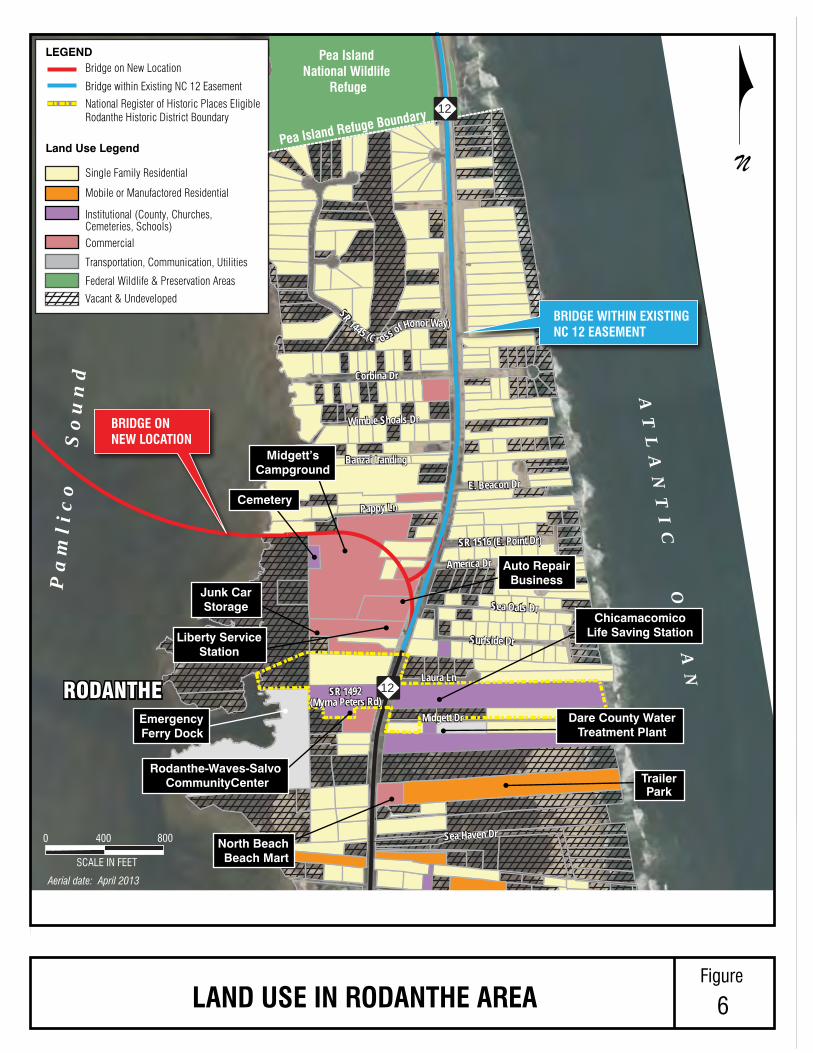
0
SCALE IN FEET
400 800
Pea Island Refuge Boundary
Bridge on New Location
Bridge within Existing NC 12 Easement
LEGEND
Land Use Legend
National Register of Historic Places EligibleRodanthe Historic District Boundary
Single Family Residential
Mobile or Manufactored Residential
Institutional (County, Churches, Cemeteries, Schools)Commercial
Transportation, Communication, Utilities
Vacant & Undeveloped
Federal Wildlife & Preservation Areas
BRIDGE ON NEW LOCATION
BRIDGE WITHIN EXISTING NC 12 EASEMENT
AT
LA
NT
IC
O
CE
AN
Pa
ml i
co
S
ou
nd
Pea Island National Wildlife
Refuge
12
12
Surfside Dr
Sea Oats Dr
America Dr
SR 1516 (E. Point Dr)
E. Beacon Dr
Pappy Ln
Banzai Landing
Wimble Shoals Dr
Pappy Ln
Banzai Landing
Wimble Shoals Dr
Corbina Dr
Surfside Dr
Sea Oats Dr
America Dr
SR 1516 (E. Point Dr)
E. Beacon Dr
Corbina Dr
SR 1445 (C r oss of Honor Way)
Sea Haven DrSea Haven Dr
Midgett Dr
SR 1492(Myrna Peters Rd)
SR 1492(Myrna Peters Rd)
Laura Ln
Midgett Dr
Laura Ln
SR 1445 (C r oss of Honor Way)
RODANTHERODANTHE
Liberty ServiceStation
Junk CarStorage
Rodanthe-Waves-Salvo CommunityCenter Trailer
Park
Auto RepairBusiness
ChicamacomicoLife Saving Station
Dare County WaterTreatment Plant
EmergencyFerry Dock
North BeachBeach Mart
Cemetery
Midgett’sCampground
N
LAND USE IN RODANTHE AREAFigure
6
Aerial date: April 2013
Bonner Bridge Replacement EA NCDOT STIP Project Number B‐2500B
Phase IIb – Rodanthe Breach
4‐3
4.1.2 Cultural Resources
There are three resources within the Phase IIb project area listed on or eligible for
inclusion in the National Register of Historic Places (NRHP):
Pea Island National Wildlife Refuge (Refuge) (eligible)
Chicamacomico Life Saving Station (listed)
Rodanthe Historic District (eligible)
These resources were described in detail in Section 3.4.1 of the 2008 FEIS, beginning on
page 3‐28. The Refuge within the Phase IIb project area is shown on Figure 3. The
boundaries of the Life Saving Station and the Rodanthe Historic District are shown in
Figure 6. Hurricanes Irene and Sandy had no effect on the features of the three
resources that make them eligible for inclusion in the NRHP.
4.1.3 Parks and Recreation/Wildlife Refuges
The Phase IIb project area is partially within the Pea Island National Wildlife Refuge
(Refuge), whose jurisdiction substantially overlaps with that of the Cape Hatteras
National Seashore (Seashore) (See Figure 7). The Refuge is characterized by ocean
beach, dunes, upland, fresh and brackish water ponds, salt flats, and salt marsh. It is
inhabited by an extensive number of bird species, as well as a variety of mammals,
reptiles, and amphibians. A variety of recreational opportunities also exist within the
Refuge, including fishing, birding, surfing, walking, kayaking, and going to the beach
(sunbathing). The detailed characteristics of the Refuge are described in Section 3.5.2 of
the 2008 FEIS, beginning on page 3‐40. Except for sand overwash and associated dune
loss and damage (both considered by USFWS‐Refuge staff to be a part of acceptable
natural processes), Hurricanes Irene and Sandy had a minimal effect on the Refuge in
the Phase IIb project area. Effects in the Phase IIb project area included NCDOT
construction activities and detours (in 2012 and 2013) following Hurricane Irene to close
the breach opened by the hurricane, restore the sandbag‐filled dune just north of
Rodanthe, and repair/clear and re‐open NC 12. For repairs following Hurricane Irene, a
CAMA major permit and a USFWS Special Use Permit were obtained. NCDOT also
prepared a CE for this work to fulfill the requirements of NEPA. The sandbag filled
dune and NC 12 were again repaired following Hurricane Sandy.
4.1.4 Coastal Conditions
Coastal processes drive the physical changes in the Phase IIb project area. This section
discusses existing conditions and trends in the Phase IIb project area, including:
Rodanthe breach resulting from Hurricane Irene and potential for breaching
Rodanthe ‘S’ Curves Hot Spot
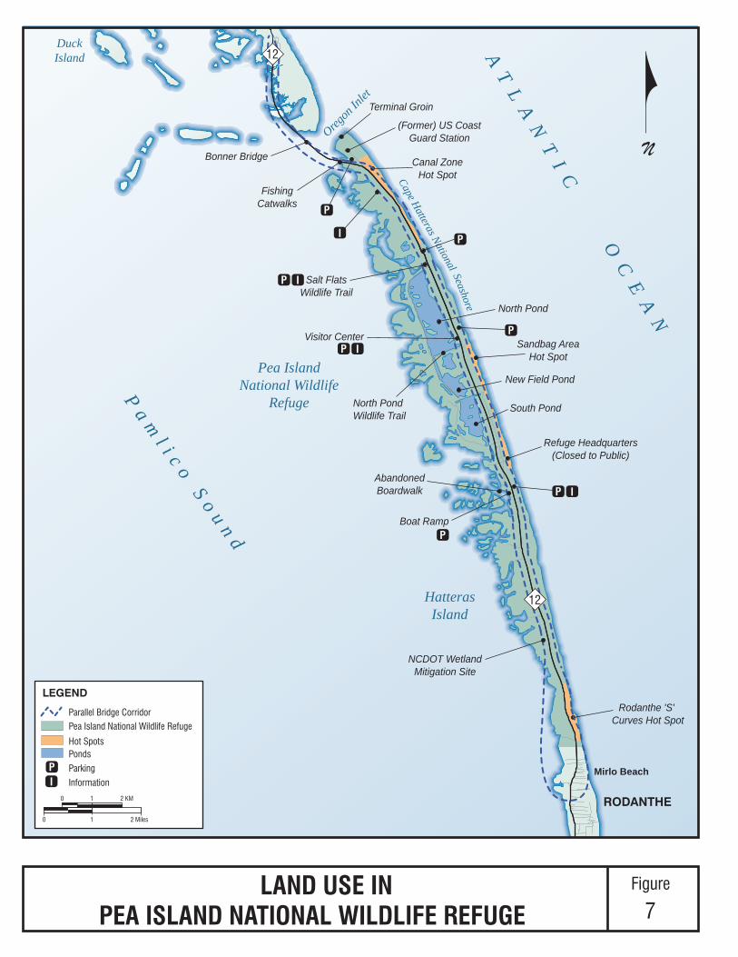
Canal ZoneHot Spot
(Former) US CoastGuard Station
Terminal Groin
Bonner Bridge
Sandbag AreaHot Spot
Visitor Center
Salt FlatsWildlife Trail
FishingCatwalks
Rodanthe 'S' Curves Hot Spot
South Pond
New Field Pond
North Pond
North PondWildlife Trail
Oregon
Inlet
AT
LA
NT
IC
OC
EA
N
Pa m
l i c o S o u n d
DuckIsland
Cape Hatteras National Seashore
12
12
RODANTHE
Mirlo Beach
HatterasIsland
Pea IslandNational Wildlife
Refuge
NCDOT WetlandMitigation Site
Boat Ramp
Refuge Headquarters(Closed to Public)
AbandonedBoardwalk
P
P I
P
P
P
P
I
P I
I
N
Pea Island National Wildlife Refuge
Hot SpotsPonds
Parking
Information
LEGEND
LAND USE INPEA ISLAND NATIONAL WILDLIFE REFUGE
Figure
7
PI
10
0 1 2 KM
2 Miles
Parallel Bridge Corridor

Bonner Bridge Replacement EA NCDOT STIP Project Number B‐2500B
Phase IIb – Rodanthe Breach
4‐5
Forecast shoreline changes through 2060
Existing coastal conditions for the entire Phase II project area are described in Section 3.6
of the 2008 FEIS; this discussion includes the location of floodplains, Oregon Inlet
migration, changes in the Oregon Inlet gorge (deepest part) alignment and location,
historical shoreline changes, factors that drive inlet and shoreline changes, the Hatteras
Island shoreline through 2060 (based on data through June 2004), potential breach
locations, and forecast Oregon Inlet movement through 2085. Recent updates related to
the formation of Pea Island inlet, potential for Pea Island inlet migration or closure
(closed as of the date of this Phase IIb EA), Pea Island inlet depth, and natural factors
affecting inlet and shoreline changes are presented in the Phase IIa EA in Section 4.1.2
beginning on page 4‐3.
Many of the decisions related to phasing and the starting and ending points of various
phases of the PBC/TMP Alternative were based on a forecast 2060 high‐erosion shoreline
from Oregon Inlet to Rodanthe and locations geologically susceptible to breaches. The
2060 high‐erosion shoreline forecast was updated in 2012 using shoreline change data
through the end of 2011 (Overton, 2013) and discussed in Section 4.1.2.6 of the Phase IIa
EA, beginning on page 4‐8. A new shoreline forecast adding 2012 erosion data was
completed in 2013 and is illustrated in Appendix D of this EA along with the two
previous forecasts. Where forecast lines overlap, the most recent is shown. The biggest
change from the 2011 forecast is in Rodanthe where the 2060 high erosion shoreline is
approximately 40 to 80 feet further east. Changes between the 2060 high‐erosion
shoreline assumed in the 2008 FEIS and the updated forecast for the Phase IIb project
area are presented for the Phase IIb project area in this section.
4.1.4.1 Rodanthe Breach
In August 2011, Hurricane Irene created breaches on NC 12 at two locations: within the
Refuge (Phase IIa project area) and within northern Rodanthe (Phase IIb project area,
including the Rodanthe ‘S’ Curves Hot Spot). Hurricane Irene produced a soundside
(western shore) storm surge. The Rodanthe breach occurred immediately north of
Rodanthe at the southern limit of the Refuge. As a part of restoring NC 12, NCDOT
closed the breach by filling it in with sand obtained from a site in Avon. NCDOT
prepared a Categorical Exclusion (CE) for this work to fulfill the requirements of NEPA.
The CE, approved in September 2011, demonstrated that this work would have no
significant environmental impact. Other actions taken as a result of Hurricane Irene to
restore NC 12 at the Rodanthe ‘S’ Curves Hot Spot are described in the next section.
During the Peer Exchange meeting in October 2011 (described in Section 2.6.2 of the
Phase IIa EA3), panel members agreed that the two breaches resulting from Hurricane
3 On October 24 and 25, 2011, NCDOT assembled a panel of coastal science and engineering
experts from FHWA, USACE, USFWS‐Refuge, and several universities. The purposes of the

Bonner Bridge Replacement EA NCDOT STIP Project Number B‐2500B
Phase IIb – Rodanthe Breach
4‐6
Irene were not caused by the storm surge on the ocean side. Also, they agreed that the
storm surge flooded man‐made ditches to the west of the Rodanthe breach location and
continued to the ocean to create the Rodanthe breach. The Phase IIb project area
contains two adjoining locations considered geologically susceptible to breaching that
encompass most of the Phase IIb project area (see Figure 3). These potential breach sites
were described in Section 3.6.3.4 of the 2008 FEIS beginning on page 3‐59.
4.1.4.2 Rodanthe ‘S’ Curves Hot Spot
In August 1991, the NCDOT sponsored a research project conducted by North Carolina
State University to identify critical sections of North Carolina’s coastal highways and
options available for maintaining these highway corridors. The study concluded that
NC 12 has six critical sections, or “hot spots,” between Oregon Inlet and the
southwestern tip of Ocracoke Island. Three of the hot spots are at the north end of
Hatteras Island (within the Bonner Bridge Replacement Project [B‐2500] project area):
Canal Zone, Sandbag Area, and Rodanthe ‘S’ Curves.
The Phase IIb project area, which includes the Rodanthe ‘S’ Curves Hot Spot, has the
highest erosion rates in the Bonner Bridge Replacement Project (B‐2500) project area.
The 2011 Peer Exchange meeting panel affirmed that erosion rates in Rodanthe (in
particular, at the Mirlo Beach subdivision) were amongst the highest rates along the
North Carolina coast. The subsurface rock structure (Wimble Shoals) in the vicinity of
the northern Rodanthe area concentrates wave energy in the area and leads to wave
refraction that contributes to high beach erosion and vulnerability for breaches. This also
contributes to the susceptibility of the area to ocean flooding and overwash.
Since 2006, NCDOT has conducted a series of repairs at the Rodanthe ‘S’ Curves Hot
Spot to restore/maintain NC 12 following major storm events:
November 2006 – Installed a 900‐foot section of sandbag‐filled dune adjacent to
NC 12 to protect the roadway.
November 2009 – Following Hurricane Ida, relocated approximately 1,860 feet of the
roadway 23 feet west, remaining within the existing NC 12 easement in the Refuge.
The 900 feet of sandbags built in 2006 were removed and replaced, and an additional
350‐foot section of sandbag‐filled dune was installed on the south end of the original
900 feet (total of 1,250 feet). In association with this effort, a beach habitat restoration
(nourishment) project took place at the Rodanthe ‘S’ Curves Hot Spot in 2010. The
meeting were to: 1) evaluate the changes in the setting at both Pea Island and at Rodanthe as a
result of Hurricane Irene, 2) provide engineering advice regarding the design constraints of long‐
term options at both locations. and 3) identify any concerns regarding the future maintenance of
NC 12.
Bonner Bridge Replacement EA NCDOT STIP Project Number B‐2500B
Phase IIb – Rodanthe Breach
4‐7
beach habitat restoration was done at the request of USFWS, through a condition of
the 2006 Special Use Permit authorizing the original sandbag project.
August 2011 – Severe damage to the sandbag‐filled dune area occurred as a result of
Hurricane Irene; the dune was rebuilt following the storm.
March 2013 ‐ Some sandbag‐filled dune loss occurred during Hurricane Sandy
(October 2012) and was repaired.
The Rodanthe ‘S’ Curves Hot Spot is currently the location on northern Hatteras Island
where NC 12 appears to be most vulnerable to storm damage.
4.1.4.3 Forecast Shoreline Changes through 2060 in the Phase IIb Project Area
As part of the coastal monitoring program, updated coastal conditions data for the
Bonner Bridge Replacement Project (B‐2500) project area were collected starting in early
2011. Background information and improvements to methodology, which are
applicable to both the Phase IIa and Phase IIb projects, are discussed in detail in Section
4.1.2.6 of the Phase IIa EA (beginning on page 4‐8).
In comparison to the 2008 FEIS shoreline forecasts (using data through June 2004), the
updated 2060 high‐erosion shoreline (using data through 2012) in the Phase IIb project
area shows similar forecast erosion in the Refuge portion of the Rodanthe ‘S’ Curves Hot
Spot and less erosion (approximately 300 to 570 feet less) in Rodanthe. The current
shoreline in the vicinity of the Refuge boundary is between the 2020 average‐erosion
shoreline and the 2010 high‐erosion shoreline presented in the 2008 FEIS.
A comparison of the 2060 high‐erosion shoreline forecast from the 2008 FEIS (using data
through June 2004), the updated forecast using data through 2011, and the updated
forecast using data through 2012 is shown for the Phase IIb project area in Figure D‐1 in
Appendix D.
4.1.5 Biotic Communities, Wetlands, and Open Water Habitat
Wetlands and open water habitat are discussed in Section 3.7.4 of the 2008 FEIS, as well
as Section 4.1 of the Natural Resources Technical Report (CZR, Incorporated, 2008). A total
of 20 biotic communities were mapped within the entire Bonner Bridge Replacement
Project (B‐2500) project area based on field surveys conducted between 2003 and 2005,
including ten wetland biotic communities and one jurisdictional open water community.
In 2012, NCDOT updated the wetland delineations. Section 404 jurisdictional and
Coastal Area Management Act (CAMA) coastal wetland boundaries were updated, and
NPS wetland boundaries were determined. The revised wetland boundaries were
approved by USACE, NCDENR‐DCM, and NPS. The Phase IIb impact assessment
presented herein uses these new wetland delineations. It should be noted that these
updates were completed and approved prior to Hurricane Sandy in October 2012. A

Bonner Bridge Replacement EA NCDOT STIP Project Number B‐2500B
Phase IIb – Rodanthe Breach
4‐8
review of aerial photography after Hurricane Sandy showed that in the Phase IIb project
area affected, new areas of overwash sand appeared, likely affecting a small amount of
wetland that was recently delineated. However, the total amount of overwash areas was
not calculated, nor was the depth of the overwash sand evaluated. Depending on the
depth of the sand, wetland communities could quickly recover or be turned into upland
communities.
As part of this updated analysis of jurisdictional areas within the Phase IIb project area,
some of the upland communities listed in the 2003 and 2005 survey results were
consolidated, and some wetland communities were also merged (e.g., black needle rush,
brackish marsh, and smooth cordgrass became marsh) because of the complex and
mosaic nature of the occurrence of these communities. In addition to marsh, several of
the previously described wetland biotic communities (salt shrub and grassland and a
combination of the two, and maritime shrub and grassland and a combination of the
two) were designated as additional CAMA variant communities. The CAMA
designation identifies communities that receive tidally influenced flooding and contain
species subject to regulation as “coastal wetlands,” a category of Areas of Environmental
Concern (AEC). These CAMA variant communities, plus the marsh community, contain
“AEC coastal wetlands” which are subject to NCDENR‐DCM jurisdiction under CAMA,
as well as Section 404.
Within the Phase IIb project area, Section 404 jurisdictional areas occur within 18
wetland biotic communities and four open water communities (see Table 2). Open
water categories consist of open water, pool, ditch, and culvert. Pools include several
small interdunal ponds between NC 12 and the primary dune field. Pools are not
regularly connected to other waters and are mostly permanent or frequently flooded.
Rainfall is the most common source of input for the pools. Ditches and culvert areas are
mostly maintained areas found in association with NC 12. All other open water areas
include the waters of Pamlico Sound, nearshore ocean, and some ditches that are
directly connected to the sound. Open water includes intertidal areas (including mud
flats) and some man‐modified areas (i.e., dug‐out or excavated areas within natural
marsh).
A comparison of the previous biotic communities mapping and the updated mapping
within the approximate 1028‐acre Phase IIb project area (see Table 2) shows Section 404
jurisdictional wetland areas (all wetlands, including CAMA wetlands) decreased 23.61
acres from 235.77 acres to 212.16 acres with the 2012 delineation and jurisdictional
waters (open water, culverts, ditches, pools) increased by 39.26 acres from 351.57 acres
to 390.83 acres. Additionally, areas regulated as CAMA AEC areas (CAMA
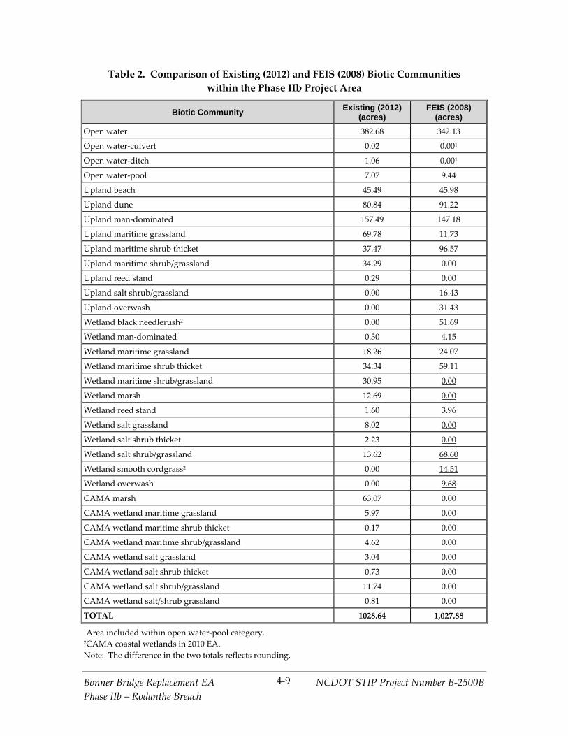
Bonner Bridge Replacement EA NCDOT STIP Project Number B‐2500B
Phase IIb – Rodanthe Breach
4‐9
Table 2. Comparison of Existing (2012) and FEIS (2008) Biotic Communities
within the Phase IIb Project Area
Biotic Community Existing (2012) (acres)
FEIS (2008) (acres)
Open water 382.68 342.13
Open water‐culvert 0.02 0.001
Open water‐ditch 1.06 0.001
Open water‐pool 7.07 9.44
Upland beach 45.49 45.98
Upland dune 80.84 91.22
Upland man‐dominated 157.49 147.18
Upland maritime grassland 69.78 11.73
Upland maritime shrub thicket 37.47 96.57
Upland maritime shrub/grassland 34.29 0.00
Upland reed stand 0.29 0.00
Upland salt shrub/grassland 0.00 16.43
Upland overwash 0.00 31.43
Wetland black needlerush2 0.00 51.69
Wetland man‐dominated 0.30 4.15
Wetland maritime grassland 18.26 24.07
Wetland maritime shrub thicket 34.34 59.11
Wetland maritime shrub/grassland 30.95 0.00
Wetland marsh 12.69 0.00
Wetland reed stand 1.60 3.96
Wetland salt grassland 8.02 0.00
Wetland salt shrub thicket 2.23 0.00
Wetland salt shrub/grassland 13.62 68.60
Wetland smooth cordgrass2 0.00 14.51
Wetland overwash 0.00 9.68
CAMA marsh 63.07 0.00
CAMA wetland maritime grassland 5.97 0.00
CAMA wetland maritime shrub thicket 0.17 0.00
CAMA wetland maritime shrub/grassland 4.62 0.00
CAMA wetland salt grassland 3.04 0.00
CAMA wetland salt shrub thicket 0.73 0.00
CAMA wetland salt shrub/grassland 11.74 0.00
CAMA wetland salt/shrub grassland 0.81 0.00
TOTAL 1028.64 1,027.88
1Area included within open water‐pool category. 2CAMA coastal wetlands in 2010 EA.
Note: The difference in the two totals reflects rounding.
Bonner Bridge Replacement EA NCDOT STIP Project Number B‐2500B
Phase IIb – Rodanthe Breach
4‐10
communities in the 2012 delineation and wetland black needlerush and wetland smooth
cordgrass in the previous delineation) increased by 23.95 acres from 66.20 acres to 90.15
acres. In general, most changes between the two evaluations are associated with shrub
thickets (upland and wetland), which occupied 15.15 percent of the project area in the
2008 FEIS, but occupy about 7.20 percent of the Phase IIb project area in 2012. The
reduction in the area of maritime shrub thickets may be as a result of less protection
from salt spray and/or storm damage, allowing grasses to become co‐dominant or more
prevalent within these former shrub‐dominated communities. Many areas formerly
occupied by maritime shrub thickets are now occupied by maritime shrub/grassland,
salt shrub/grassland, salt grassland, and maritime grassland communities.
4.1.6 Protected Species
The Biological Assessment (BA) (FHWA and NCDOT, 2008) for the Bonner Bridge
Replacement Project (B‐2500), as well as Section 3.7.7 of the 2008 FEIS, addressed 12
species granted protection under Section 7 of the ESA of 1973 and critical habitat for one
species, the piping plover, which occurs near Oregon Inlet. These protections were
designated by USFWS and/or NMFS, a division of the National Oceanic and
Atmospheric Administration (NOAA). In February of 2012, one additional species
beyond those assessed in the 2008 BA, the Atlantic sturgeon (Acipenser oxyrinchus), was
designated as “endangered” and granted protection by NMFS. The Atlantic sturgeon
was discussed in Section 4.2.4.4 of the Phase IIa EA and in a 2013 technical
memorandum for the Atlantic Sturgeon (CZR Incorporated, 2013). As previously
documented, the Phase IIb project area offers habitat for the following protected species:
Piping plover foraging habitat (beach)
Roseate tern (beach and interdune)
Five species of sea turtles:
Hawksbill sea turtle (ocean)
Kemp’s ridley sea turtle (ocean and sound)
Leatherback sea turtle (ocean, sound, and beach)
Green sea turtle (ocean, sound, and beach)
Loggerhead sea turtle (ocean, sound, and beach)
Two species of sturgeon
Shortnose sturgeon (ocean and sound)
Atlantic sturgeon (ocean and sound)

Bonner Bridge Replacement EA NCDOT STIP Project Number B‐2500B
Phase IIb – Rodanthe Breach
4‐11
Seabeach amaranth (beach and dunes)
New foraging and potential nesting habitat for piping plovers and other beach nesting
birds was created as a result of Hurricane Irene and subsequent storms, including
Hurricane Sandy. The open, bare sandy overwash areas east and west of NC 12 serve as
ephemeral habitat areas that provide potential nesting habitat for the piping plover and
other early successional beach nesters, such as the least tern (Sternula antillarum), the
American oystercatcher (Haematopus palliatus), and several other waterbird species.
There is little ideal habitat for piping plovers in the Phase IIb project area. Several least
tern nesting colonies, which sometimes nest in association with piping plovers, were
documented in the NCDOT bird surveys referenced in Section 2.6.4 of the Phase IIa EA
(conducted from December 2011 through November 2012) along NC 12 between Oregon
Inlet and the new Pea Island inlet. Updates to the bird surveys through August 2013 are
presented in Section 2.6.2.1 of this EA. Many least terns and at least one pair of
American oystercatchers also used as a nesting area in 2012 the area formerly occupied
by the Refuge headquarters buildings, just south of the Pea Island inlet. More nests
were found in 2013, but none were piping plover nests. The Phase IIb project area was
not surveyed during 2012 but was in 2013.
4.1.7 Essential Fish Habitat
Since the preparation of the Essential Fish Habitat Assessment (CZR, Incorporated, 2008)
for the Bonner Bridge Replacement Project (B‐2500), as well as Section 3.7.6.3 of the 2008
FEIS (beginning on page 3‐91), red drum (Sciaenops ocellatus) is no longer managed by
the South Atlantic Fisheries Management Council (SAFMC). No new species have
become managed by SAFMC or other state or federal fisheries management entities.
Red drum are still managed by the Atlantic States Marine Fisheries Commission
(ASMFC), which serves as a deliberative body, coordinating the conservation and
management of the states’ shared nearshore fishery resources and the NC Division of
Marine Fisheries.
Essential fish habitat in the Phase IIb project area has not substantially changed since the
2008 FEIS. It includes soundside wetlands (estuarine emergent), submerged aquatic
vegetation in the sound (seagrass), and open water in the sound (estuarine water
column).
In general in the Phase IIb project area, waters less than 6 feet deep within Pamlico
Sound are considered potential SAV habitat. The North Carolina Marine Fisheries
Commission (NCMFC) defines SAV habitat as an area that is currently vegetated with
one or more appropriate (native) SAV species, or an area that has been vegetated by one
or more appropriate species within the past 10 annual growing seasons and meets the
average growing conditions needed (water depth of 6 feet or less, average light
availability [Secchi depth of 1 foot or more], and limited wave exposure). The total
Pamlico Sound (open water) impacts reflect the impact to SAV habitat.

Bonner Bridge Replacement EA NCDOT STIP Project Number B‐2500B
Phase IIb – Rodanthe Breach
4‐12
Evaluation of SAV in the 2008 FEIS and 2010 EA was based on general DENR‐DMF
maps generated with pre‐2000 aerial data (the latest available at the time). NCDOT
conducted on‐site SAV surveys in the Rodanthe area in 2009, 2011, 2012, and 2013 and
generated a SAV map using 2012 aerial photography. NCDOT SAV data from 2009
through 2013 have documented more SAV in the Rodanthe area compared to the pre‐
2000 DENR‐ DMF SAV maps used in 2008 and 2010. Some of the additional SAV
coverage documented by NCDOT is likely the result of better aerial mapping tools and
data and more extensive on‐site surveys by NCDOT.
Based on the 2012 aerial SAV mapping, all open water of the Pamlico Sound crossed by
the Phase IIb Bridge on New Location Alternative contain either “patchy” or “sparse”
SAV. On‐site surveys from this area in 2013 documented that 88 percent of the surveyed
plots contained SAV, and of the plots with SAV, shoal grass (Halodule wrightii) was
found in 55 percent of the plots, widgeon grass (Ruppia maritime) was found in 55
percent of the plots, and eel grass (Zostera marina) was found in 46 percent of the plots.
The surveys found that 45 percent of the plots surveyed had 60 percent or greater
coverage. The 2013 SAV survey data also found that the southern half of the Bridge on
New Location Alternative alignment over the sound was comprised of generally deeper
water depths dominated by eel grass and widgeon grass, while the northern half
consisted of shallower water with firmer and sandier substrate and was dominated by
shoal grass.
4.2 Updated Impacts of the Phase IIb Detailed Study Alternatives
This section updates the impact discussions presented in Chapter 4 of the 2008 FEIS and
Section 2.3.3 of the 2010 EA. It focuses on updates relevant to Phase IIb of the Bonner
Bridge Replacement Project (B‐2500). The characteristics of the Phase IIb detailed study
alternatives evaluated in this EA, the Bridge on New Location Alternative and the
Bridge within Existing NC 12 Easement Alternative, would be similar to what was
defined in the 2008 FEIS as the Bridge South component of the Road North/Bridge South
and as the Phased Approach/ Rodanthe Bridge alternatives, respectively. Changes in
impacts are associated with minor changes in the characteristics of the project area and
refinements to the 2008 designs of the two detailed study alternatives. In general, these
changes reduced or did not substantially change impacts.
As a result of changes in project area conditions and in the designs of the detailed study
alternatives, some impacts have changed since they were last presented in the 2008 FEIS
and 2010 EA. This section addresses changes in the following types of impacts:
Community impacts
Visual impacts

Bonner Bridge Replacement EA NCDOT STIP Project Number B‐2500B
Phase IIb – Rodanthe Breach
4‐13
Cultural resource impacts
Parks and recreation impacts
Natural systems impacts
Noise impacts
Air quality impacts
Indirect and cumulative impacts findings contained in Section 4.12 of the 2008 FEIS are
unchanged. In terms of indirect impacts, as discussed in Section 4.12.5 of the 2008 FEIS,
construction of a project in the Parallel Bridge Corridor would not induce changes in
development trends, because the project does not have an economic development
purpose and is consistent with local area land use plans. In addition, it would not serve
a specific land development, would be unlikely to stimulate land development having
complementary functions, and would be unlikely to influence substantial intraregional
land development location decisions since it would replace an existing two‐lane facility
with a new two‐lane facility. Finally, it is not being introduced to an area with notable
natural features that could be lost to development.
In terms of cumulative impacts, based on discussions in Section 4.12.6 of the 2008 FEIS:
Phase IIb detailed study alternatives would not interfere with the Outer Banks Task
Force’s goal to implement a long‐term solution to the effect of shoreline erosion and
ocean overwash on NC 12 at the three hot spot locations in the Bonner Bridge
Replacement Project (B‐2500) project area. The Phase IIb detailed study alternatives
would in fact implement a long‐term solution to the effects of shoreline erosion and
ocean overwash on NC 12 at the Rodanthe ‘S’ Curves Hot Spot.
Phase IIb would change access within the Refuge in that there would be no direct
access to the Refuge between the ends of either detailed study alternative, as
described in Section 4.2.4.
Phase IIb detailed study alternatives would not interfere with the benefits to USACE
dredging offered by Phase I of the PBC/TMP Alternative.
Phase IIb detailed study alternatives would not change the potential impact of the
PBC/TMP on the preservation of the (former) Oregon Inlet US Coast Guard Station.
Phase IIb would help maintain access to the station from the southern part of
Hatteras Island.
Phase IIb detailed study alternatives would not change the need to retain the
terminal groin at Oregon Inlet that is associated with the PBC/TMP Alternative.

Bonner Bridge Replacement EA NCDOT STIP Project Number B‐2500B
Phase IIb – Rodanthe Breach
4‐14
With Phase IIb detailed study alternatives, the options for future relocation of
utilities along NC 12 (moving them back multiple times in response to shoreline
erosion or moving them back once to beyond the 2060 high‐erosion shoreline) would
still be available.
With the Phase IIb Bridge on New Location Alternative, the cumulative effects of
habitat loss or changes on the ecological integrity of the Outer Banks would be
nearly identical to the Bridge South component of the Road North/Bridge South
Alternative assessed in the 2008 FEIS. Like the Road North/Bridge South
Alternative, the Phase IIb Bridge on New Location Alternative would, at the south
end of the Refuge and in Rodanthe, place NC 12 on a bridge west of Hatteras Island.
This alternative would have direct impacts to natural habitat in the sound; however,
the natural shoreline erosion process would be allowed to take place without
affecting the integrity of NC 12.
With the Phase IIb Bridge within Existing NC 12 Easement Alternative, the
cumulative effect of habitat loss or change on the ecological integrity of the Outer
Banks would be nearly identical to the Phased Approach/Rodanthe Bridge
Alternative assessed in the 2008 FEIS. Like the Phased Approach/Rodanthe Bridge
Alternative, the Phase IIb Bridge within Existing NC 12 Easement Alternative would
place NC 12 on a bridge in the existing easement, resulting in the least initial direct
impact to natural habitat as compared to the other PBC/TMP Alternative future
phase options. Natural shoreline processes would be allowed to take place. The
shoreline would erode underneath the bridge. Like the Phased Approach/Rodanthe
Bridge Alternative, ultimately the Bridge within Existing NC 12 Easement
Alternative would have portions located over the beach and in the ocean, with the
associated direct impacts described later in Sections 4.2.4.2 and 4.2.5.
NCDOT also plans an NC 12 maintenance action associated with efforts to stabilize and
maintain the reliability of NC 12 at the Rodanthe ‘S’ Curve Hot Spot until the proposed
Phase IIb long‐term project is implemented. As an interim measure, it would likely
involve one round of beach nourishment. The USACE approved an EA for this interim
measure on October 15, 2013. USACE concluded that this project would have no
significant impacts. Other options considered were a temporary bridge or continuing to
maintain the existing sandbag dune (for which a CE was done in the context of
obtaining the Special Use Permit for the dune from the USFWS). Beach nourishment
was chosen as the preferred alternative.
The 2008 FEIS examined likely maintenance activities on NC 12 until the PBC/TMP
Alternative was completed (Section 4.6.8.6, beginning on page 4‐68) and their potential
impacts (Section 4.7.8, beginning on page 4‐115). The listing of potential maintenance
activities was developed by the study team’s coastal engineer; based on coastal data
available at the time, the need for interim nourishment was not forecast. The 2008 FEIS

Bonner Bridge Replacement EA NCDOT STIP Project Number B‐2500B
Phase IIb – Rodanthe Breach
4‐15
did, however, assess a long‐term Nourishment Alternative and its impacts are addressed
in Chapter 4 of the 2008 FEIS. An interim nourishment program essentially would be
one round of nourishment in one part of the Bonner Bridge Replacement Project (B‐2500)
project area. Therefore, the potential impacts of nourishment in the Rodanthe ‘S’ Curves
Hot Spot area are addressed in the 2008 FEIS and were taken into consideration in the
selection of the PBC/TMP Alternative in the 2010 ROD.
4.2.1 Community Impacts
This section discusses changes in relocation and other community impacts associated
with the two detailed study alternatives since the 2008 FEIS, as updated in the 2010 EA.
These changes result primarily from changes in the design of the Bridge within Existing
NC 12 Easement Alternative made in response to the 2060 high erosion shoreline
forecast completed in 2013. In addition, one business building now contains fewer
businesses than previously counted, and a camping trailer park (business) has been built
within the proposed right‐of‐way of the Bridge on New Location Alternative. The two
detailed study alternatives would result in the relocations shown in Table 3.
Table 3. Relocations
Detailed Study Alternatives Homes Businesses
2010 EA (Table 2‐1 on page 2‐7)
Bridge on New Location (Bridge South) 2 5
Bridge within Existing NC 12 Easement (Phased
Approach/Rodanthe Bridge) 6 7
Current Conditions/Detailed Study Alternatives Design
Bridge on New Location 21 2
Bridge within Existing NC 12 Easement 5 2
1This number does not include the relocation of camping trailers parked in the camping trailer
park (one business relocation). The owner of this business indicated that of the 23 sites,
approximately 12 to 14 are rented on a long‐term (yearly) basis, but that in accordance with Dare
County regulations, the sites are not used for permanent residence. Seven are currently
occupied within the acquisition area of this alternative. All but five of the 23 sites are affected by
the Bridge on New Location Alternative.
Updated NCDOT relocation reports, particularly addressing 2013 preliminary designs
for the detailed study alternatives, are included in Appendix E. Consistent with
relocation information documented in the 2008 FEIS, updated reports indicate that
impacts to minorities, large families, disabled persons, or others who would have special
problems being relocated would not be substantial. No special relocation services
would be necessary. Residential relocations would not cause a housing shortage. There

Bonner Bridge Replacement EA NCDOT STIP Project Number B‐2500B
Phase IIb – Rodanthe Breach
4‐16
is adequate decent, safe, and sanitary housing that is expected to be available during the
relocation period. There is a concern that if any of the residential buildings displaced
contain permanent residents, the replacement housing could be up to 5 to 10 miles away
because of the predominance of vacation homes in the Rodanthe area. Suitable sites for
relocation of the displaced businesses are also available and business services would still
be available after project implementation. Detailed information on the NCDOT policy to
ensure comparable replacement housing and the North Carolina Board of
Transportation’s programs to minimize the inconvenience of relocation is provided in
Section 4.1.1 of the 2008 FEIS.
The owner of the business building that houses an auto repair shop and the new
camping trailer park (business) is also the owner of the Liberty gas station/Island
Convenience Store in the same area on the west side of existing NC 12. The southern
termini of both detailed study alternatives are located in this area. The business
building was damaged in Hurricane Irene; it had previously housed several businesses,
but currently houses only an auto repair shop. The Bridge within Existing NC 12
Easement would require taking the Liberty gas station/ Island Convenience Store and
auto repair business, while the Bridge on New Location would require the taking of the
auto repair business and the campground. The owner of these businesses has indicated
a preference for the Bridge on New Location Alternative because of a desire to preserve
the Liberty gas station/ Island Convenience Store, which is the family’s main source of
income. Further, the Liberty gas station/ Island Convenience Store is an important part
of the Rodanthe community. Local residents depend on it for gas, groceries, and other
necessities. It provides a gathering spot for locals during non‐tourist season months.
The relocations do not represent a new significant impact because they are lower than
identified in the 2010 EA.
A gravesite on Seagull Street would be avoided by both detailed study alternatives.
Table 2‐1 of the 2010 EA also noted that what is now the Bridge on New Location
Alternative could cross a cemetery, but that no known gravesites would be affected.
Both the 2010 Bridge South design and the 2013 Bridge on New Location design show
the bridge approach passing close to the cemetery. The associated new right‐of‐way
includes a “cut‐out” that follows the cemetery boundary so that the right‐of‐way does
not take a portion of the cemetery property. This is important. Without this “cut‐out,”
any known graves in this portion of the cemetery would need to be relocated. If graves
were to be relocated, there appears to be available space in the western part of the
cemetery for the relocation of graves. If the Bridge on New Location Alternative
becomes the Selected Alternative, NCDOT would conduct research and field surveys to
determine precisely where graves are located to ensure no unmarked graves are
unintentionally disturbed. If a decision were made to relocate gravesites, the relocation
would take place under North Carolina Statute 65‐106, Removal of Graves. As required

Bonner Bridge Replacement EA NCDOT STIP Project Number B‐2500B
Phase IIb – Rodanthe Breach
4‐17
by law, descendents would be contacted, to the extent possible, prior to moving graves.
Descendents would be involved in relocation location decision.
4.2.2 Visual Impacts
With either detailed study alternative, a new bridge would affect the viewshed within
Rodanthe, although the affected views would differ between the alternatives. The visual
impacts described below do not represent significant new impacts. These impacts were
documented in the 2008 FEIS and 2010 EA, and are generally unchanged.
4.2.2.1 Bridge on New Location Alternative
Section 4.3.1.2 of the 2008 FEIS indicated the Bridge on New Location Alternative would
result in substantial changes to panoramic and unobstructed views of the Pamlico Sound
from homes along the sound’s shoreline (and second‐story homes farther away from the
Sound) in Rodanthe. The Rodanthe area bridge would be approximately 1,200 to 2,500
feet from the soundside shoreline and the homes located along the shoreline. Exceptions
would be two homes that would be adjacent (80 and 150 feet away) to the bridge where
it crosses the shoreline in Rodanthe. The design assessed in the 2010 EA was
approximately 1,200 to 1,600 feet from the shore with the exception of the same two
homes. The greater distance from the shoreline was an additional outcome of the
alignment adjustment made in the Refuge. Because of the greater distance, the bridge
would appear thinner and the visual impact would be somewhat less than documented
in the 2010 EA.
The intactness and unity of the view would be split by the line of the Rodanthe area
bridge across the full 180 degrees of the view. At night, the lights of motor vehicles
would be visible. Roadway lighting is not planned for the proposed bridge. An aerial
representation of the Bridge on New Location Alternative is shown in Figure 8.
4.2.2.2 Bridge within Existing NC 12 Easement Alternative
Section 4.3.1.2 of the 2008 FEIS on page 4‐29 indicated that the Bridge within Existing
NC 12 Easement Alternative would substantially affect the Rodanthe area, introducing
an elevated roadway into the community. This also was true for the revised design
assessed in the 2010 EA and is the case for the Phase IIb Bridge within Existing NC 12
Easement Alternative. A representation of the Bridge within Existing NC 12 Easement
Alternative is shown in Figure 9.
Over 50 residential and/or business structures are located along NC 12 between the
Refuge boundary and the proposed southern end of the bridge and would have direct
views of the bridge. The bridge also would be seen from most homes west of the
properties adjacent to NC 12, with sightlines between, and sometimes above, the homes
and businesses that line NC 12. The elevated structure would impede the viewshed of
the primary viewers looking east towards the Atlantic Ocean and ocean‐side viewers
looking west toward the sound. Views could be blocked by the bridge as high as the

Figure
8PHOTOSIMULATION OF THE BRIDGE ON NEW LOCATION ALTERNATIVE

Figure
9PHOTOSIMULATION OF BRIDGE
WITHIN EXISTING NC 12 EASEMENT ALTERNATIVE

Bonner Bridge Replacement EA NCDOT STIP Project Number B‐2500B
Phase IIb – Rodanthe Breach
4‐20
third or fourth story. At an elevation of approximately 30.0 feet above mean sea level
(approximately 26.5 feet above ground), the bridge would be a dominating presence at
ground level, particularly for those homes and businesses close to it. Despite the slightly
lower height compared with the 2008 FEIS and 2010 EA design (see Section 2.4.3), the
combination of the bridge’s height, length, structural characteristics, and materials
would still present a structure not in keeping with the existing character of the area.
As indicated in the 2008 FEIS in Section 4.3.1.2 on page 4‐30, the potential for beach
erosion is severe in the Rodanthe area. By 2060, as a result of the beach eroding under
the bridge, the majority of the bridge would be located in the ocean and would be a
presence within ocean views for properties currently located to the west of NC 12.
4.2.3 Cultural Resource Impacts
This section describes the effects of the Phase IIb detailed study alternatives on cultural
resources, in accordance with Section 106 of the National Historic Preservation Act of
1966 (36 Code of Federal Regulations [CFR] Part 800). The cultural resource impacts
described below do not represent significant new impacts. These impacts were
documented in the 2008 FEIS and 2010 EA and are generally unchanged. Both detailed
study alternatives would have an Adverse Effect on the Refuge. The nature of the
Adverse Effect would be the visual impact on the historic landscape of the Refuge and
loss of access to Refuge features. As discussed in Section 4.4.1.2 of the 2008 FEIS
(beginning on page 4‐36), bridges in the Refuge would be a sizable new, elevated, linear,
man‐made feature. Although adverse, the impact of Phase IIb would be less with the
Bridge on New Location Alternative, in that the bridge would be within the Refuge for
approximately 0.4 mile. With the Bridge within Existing NC 12 Easement Alternative, a
bridge would be introduced to Refuge views for approximately 1.8 miles.
As indicated in Table 2‐1 of the 2010 EA, the Bridge on New Location Alternative
(labeled in the table as Road North/Bridge South) and Bridge within Existing NC 12
Easement Alternative (labeled as Phased Approach/Rodanthe Bridge) would have No
Adverse Effect on the Rodanthe Historic District and Chicamacomico Life Saving Station
since the alternatives would be outside the district. Although the alternatives would be
within the view of the resources, this view also includes modern commercial and
residential structures. The current designs of the detailed study alternatives also remain
outside the district and remain in a view that includes modern commercial and
residential structures.
4.2.4 Parks and Recreation Impacts
The parks and recreation resource impacts described below do not represent significant
new impacts. These impacts were documented in the 2008 FEIS and 2010 EA and did
not substantially change with the design refinements associated with the two detailed
study alternatives for Phase IIb.
Bonner Bridge Replacement EA NCDOT STIP Project Number B‐2500B
Phase IIb – Rodanthe Breach
4‐21
4.2.4.1 Land Use
The Phase IIb detailed study alternatives would affect land from the Refuge in a manner
similar to the Bridge South component of the Road North/Bridge South Alternative and
the portion of the Phased Approach/Rodanthe Bridge Alternative within the Phase IIb
project area. Impacts would be:
Bridge on New Location Alternative:
2.79 acres of new permanent NC 12 easement
19.27 acres of existing NC 12 easement returned to the Refuge and restored
0.63 acres of temporary construction easement in the Refuge for a temporary
traffic maintenance road to take traffic around the proposed bridge approach
Bridge within Existing NC 12 Easement Alternative:
No new permanent NC 12 easement
2.06 acres of temporary construction easement in the Refuge. In the Refuge, an
approximately 5‐foot‐wide temporary construction easement would be needed
for the entire length of the project on the sound side of the existing NC 12
easement. The purpose of this narrow easement would be primarily to provide
room for construction workers to erect erosion control measures (fencing) along
the edge of the existing NC 12 easement. A pile jetting pipe would be placed
between NC 12 and the Pamlico Sound on a 10‐foot wide temporary easement at
what is currently expected to be three locations in the Refuge. The easement in
Rodanthe would be needed to provide room for construction equipment to
operate when completing grading in the NC 12 right‐of‐way.
4.2.4.2 Recreational Use
As with the Bridge South and Phased Approach alternatives discussed in the 2008 FEIS
in Section 4.5.3 (beginning on page 4‐44), direct motor vehicle access to the Refuge
would be eliminated for the length of the bridge component of the Phase IIb detailed
study alternatives (see Figure 3). Sacrificing direct motor vehicle access in favor of
eliminating the need for artificial dunes to maintain a surface road is the preference of
USFWS, which has indicated in the past that it will provide for some form of
replacement access to the Refuge and its facilities where direct access from a surface
road is lost in Phase II and in future phases of the Bonner Bridge Replacement Project
(B‐2500).
As the beach erodes as a part of natural coastal processes, the Bridge within Existing
NC 12 Easement Alternative’s bridge would be located first over the beach and then in
the ocean. As a result, several recreational activities that occur in this area, including

Bonner Bridge Replacement EA NCDOT STIP Project Number B‐2500B
Phase IIb – Rodanthe Breach
4‐22
fishing, hiking, surfing, wind surfing, kite boarding, swimming, ocean kayaking, and
birding, would be affected both by the presence of the bridge and the loss of direct
Refuge access, as discussed in Section 4.5.3.3 of the 2008 FEIS. As with the Phased
Approach alternatives discussed in the 2008 FEIS and the Phase IIa Selected Alternative,
bridge piles in the ocean could change the types of fish that congregate around the
shore. To the extent that certain sections of the bridged roadway would be over the
beach, beach and water activities would be affected, but not precluded where it is safe,
by the presence of the bridge and bridge piles. Once the bridge piles are located in the
ocean, the ability to surf in the area affected would be eliminated. Ultimately this would
be the case for almost all of the entire 2.27‐mile Bridge within Existing NC 12 Easement
Alternative bridge. The piles would change how and where the waves break, which
would interfere with the swells in such a way that the waves would no longer be
conducive to good surfing. In addition, the presence of bridge piles in areas where the
bridge would be less than 150 feet from shore would be a safety hazard to surfers and
other recreational ocean users.
The economic impact of eliminating the paved road access to the Refuge was assessed
(2008 FEIS, Section 4.1.5.3, beginning on page 4‐12). It was determined that on average,
the losses of tourism associated with loss of access to the Refuge “would not have a
major economic impact on the Outer Banks/Dare County area.” Recreational user
surveys conducted for the economic analysis, as documented in Section 3.5.2.4 of the
2008 FEIS (beginning on page 3‐43), observed fishing (particularly from the catwalks on
Bonner Bridge and the terminal groin/sea walls at Oregon Inlet), birding, surfing, beach
use (sunbathing), walking, and kayaking as activities in the Refuge (see Table 3‐10 of the
2008 FEIS, page 3‐44). Visitors also visited the Refuge’s visitor center. As indicated in
the 2008 FEIS study, the key question in terms of the economic impact to the Outer
Banks economy is what resource/activity is lost, or to which access is reduced or lost,
and whether there is no other location on the Outer Banks to participate in the activity.
Visitor survey results in Section 4.1.5.3 of the FEIS (page 4‐12) found that without any
paved road access to the Refuge, 9 percent of Refuge visitors would not visit the Refuge
and had no other location on the Outer Banks to conduct their activity. They would thus
not visit the Outer Banks and this loss of visitors would have an economic impact.
There are other locations on the Outer Banks, including Hatteras Island, and specifically
the Seashore, where one can use a beach (sunbathing), walk, kayak, and go birding
along a beach and other natural habitats. Thus, the loss of use of beach area for these
activities because of bridge piles on the beach or offshore is not expected to have a
notable economic impact on Dare County beyond the impact associated with changed
access.
Regarding surfing, during the Phase IIa scoping comments, the Outer Banks Chapter of
the Surfrider Foundation submitted a petition (with 1,148 signatures) in favor of giving
consideration to design options that, at a minimum, provide continued, if not improved,

Bonner Bridge Replacement EA NCDOT STIP Project Number B‐2500B
Phase IIb – Rodanthe Breach
4‐23
access to the Rodanthe ‘S’ Curves Hot Spot area for surfing. The petition did not
indicate support for a particular alternative, but it stated that the ‘S’ Curves Hot Spot
area is a top surfing spot in the United States. It also emphasized the contribution of
surfing to the local economy. There are other locations on the Outer Banks, including
Hatteras Island, and specifically the Seashore, where one can surf. Therefore, the loss of
use of beach area in the Refuge and at the ‘S’ Curves Hot Spot as a surfing opportunity
because of bridge piles on the beach or offshore is not expected to have a notable
economic impact on Dare County beyond the impact associated with changed access.
Of the Refuge activities listed above, three can occur only in the Refuge: 1) fishing from
the catwalks on Bonner Bridge (under Seashore jurisdiction) and terminal groin/seawalls
at Oregon Inlet, 2) birding at the managed impoundments and Oregon Inlet, and 3)
visiting the visitor center. The first is a unique place to fish. The managed
impoundments are unique in terms of the habitat provided and the diversity and
number of bird species using these areas. In addition to the impoundments, both sides
of Oregon Inlet and adjacent habitats often attract birds not commonly seen in other
places and are targeted by visiting birders. The visitor center is inherent to USFWS‐
Refuge’s mission. None of these locations is associated with the beach or specifically the
Phase IIb detailed study alternatives.
Fishing from the catwalks was discussed in Section 4.5.3.2 of the 2008 FEIS (beginning
on page 4‐46) and revisited in Section 2.3.2.1 of the 2010 EA (page 2‐17). Phase I of the
PBC/TMP Alternative will leave a part of Bonner Bridge in place as a pier that could be
used for recreation (specifically, fishing) and provide direct road access to an existing
parking lot. This parking lot is used by those who fish at Oregon Inlet, whether from the
existing catwalks or terminal groin/seawalls, and those who do birding at Oregon Inlet.
Formal consultation with NMFS in 2013 yielded a new concern related to the effect of
existing fishing at Oregon Inlet on protected sea turtles. NMFS indicated that there is
evidence that at least four sea turtles have been hooked during recreational fishing in
Oregon Inlet since 1989 and one hooking occurred from the existing bridge catwalks in
2012. As such, NCDOT will install “no fishing” signs to not allow fishing on the
catwalks during Oregon Inlet replacement bridge construction to satisfy NMFS concerns
and for safety reasons. To satisfy NMFS concerns, “no fishing” signs also will be
installed on the portion of Bonner Bridge that will be left in place as a pier. If and when
a decision is made to allow fishing on the pier, FHWA will initiate Section 7 consultation
with NMFS prior to the “no fishing” signs being removed. (See Protected Species under
Section 3.5.1 of the Phase IIa ROD, pages 25 and 26.) If fishing is not allowed on the pier,
there could be an economic impact on Dare County because fishing at Oregon Inlet is a
unique fishing opportunity that cannot be found elsewhere in Dare County. That
impact, however, is accounted for within the 9 percent loss of Refuge visitors associated
with changed access presented in the 2008 FEIS in Section 4.1.5.3.

Bonner Bridge Replacement EA NCDOT STIP Project Number B‐2500B
Phase IIb – Rodanthe Breach
4‐24
From the perspective of birding at the impoundments, none of the alternatives assessed
in the 2008 FEIS that are a part of the PBC/TMP Alternative would preclude birding at
the impoundments, although to the extent direct road access is lost as future phases of
the PBC/TMP Alternative are built, users will have to rely on alternate access provided
by USFWS‐Refuge, as USFWS‐Refuge has indicated it would do. This is documented in
the second paragraph of page 4‐12 of the 2008 FEIS.
Finally, the visitor center could be moved. In any event, the visitor center will likely
eventually be moved because its site is forecast to be in the ocean by 2060.
As noted above, if paved road access to the Refuge were lost completely, such as with
the Pamlico Sound Bridge Alternative, 9 percent of Refuge visitors may choose not to
come to the Outer Banks, which would have the associated economic impact
documented in 2008 FEIS Section 4.1.5.3 (page 4‐12). A full 9 percent loss of Refuge
visitors would not be the case with the PBC/TMP Alternative in that it would retain
direct road access to at least two locations based on 2060 shoreline forecasts: Oregon
Inlet and between Phase IIa and Phase IIb where, based on shoreline forecasts, no
improvements to NC 12 are needed. However, at this time there is a possibility that
fishing would not be allowed from the part of Bonner Bridge left as a pier because of a
past history of protected sea turtles being hooked by fishing at Oregon Inlet. Overall,
from the perspective of access, the loss of visitors to the Refuge would be less than 9
percent with the PBC/TMP Alternative.
4.2.5 Natural Systems Impacts
The natural systems impacts described below do not represent significant new impacts.
Similar impacts were documented in the 2008 FEIS and 2010 EA and did not
substantially change with the design refinements associated with the two Phase IIb
detailed study alternatives or with changes in the affected environment that have
occurred since the release of those documents.
4.2.5.1 Surface Waters and Water Quality
As discussed in Section 4.7.2 of the 2008 FEIS on page 4‐75 and Section 4.7.2.2 of the 2008
FEIS on page 4‐82, waters associated with Pamlico Sound are classified as SA waters
(Class A saltwaters) with a supplemental classification as High‐Quality Waters (HQW).
Construction‐related water quality impacts to the open water of the sound could result
in temporary increases in turbidity and a potential decrease in dissolved oxygen;
however, given the dynamic nature of the waters in the sound, a temporary increase in
turbidity likely would not be notable as the flux of water through the sound would
reduce the potential for any permanent water quality problems. Construction of the
entire Bridge within Existing NC 12 Easement Alternative would occur over land;
therefore, direct water quality impacts during construction would not occur. Most of the
Bridge on New Location Alternative would be built over water in Pamlico Sound;
therefore, direct water quality impacts during construction would occur. Impacts would

Bonner Bridge Replacement EA NCDOT STIP Project Number B‐2500B
Phase IIb – Rodanthe Breach
4‐25
be minimized by not using dredging during bridge construction and by containing pile
jetting spoil.
As discussed in Section 4.7.2.2 of the 2008 FEIS beginning on page 4‐82, runoff from the
bridges would be a potential source of pollutants to the Atlantic Ocean (in the case of the
Bridge within Existing NC 12 Easement Alterative, when beach erosion results in its
presence in the ocean) and Pamlico Sound (Bridge on New Location Alternative). To
minimize the potential impact of project pollutants, a Post‐Construction Stormwater
Program (PCSP) would be developed in association with NCDENR‐DWR (formerly
NCDENR‐DWQ) and other state and federal environmental resource and regulatory
agencies during final bridge design and in the process of obtaining related permits.
NCDOT’s PCSP for the Phase IIb bridges is expected to be the same as the stormwater
management plan set forth for Phase I (the new Oregon Inlet bridge) and Phase IIa.
Runoff would be collected from the ends of a Phase IIb bridge and piped to a riprap
apron, which would drain to roadside swales to promote infiltration. Bridge drainage
for the main bridge spans would be from deck drains (openings) at the outer edges of
the deck. The bridge would be high enough to allow wind to disperse the deck drain
discharge before it reaches the ground or water surface. Best Management Practices
(BMPs) discussed in Section 4.7.2.2 of the 2008 FEIS (pages 4‐83 to 4‐84) would apply to
both alternatives.
4.2.5.2 Biotic Communities
Biotic communities in the study area would be impacted permanently and temporarily
as a result of project construction. The impacts to biotic communities in the Phase IIb
project area are presented in Table 4.
Fill/pile and shading are two types of permanent impacts or effects associated with the
project. Permanent fill impacts involve changing the ground surface by earth moving or
placement of fill. Piles are a key component of bridge foundations or bents upon which
bridge spans rest. Permanent pile impacts are the area of land used by the piles if the
pile cap that connects the piles together is immediately under bridge spans and above
the ground. When the pile cap is at ground level or at the surface of open water, then
the area of the pile cap is considered the area of permanent impact. Shading is the area
of bridge deck less the pile impacts.
Consistent with the bridge foundation design used for the in‐easement (preferred)
alternative for the Phase IIa project, pile caps at ground level are assumed for the Phase
IIb Bridge within Existing NC 12 Easement Alternative. With the Bridge on New
Location Alternative, either location for the pile cap could be used. In the 2010 EA, the
pile cap was assumed to be just below the bridge spans in the impact assessment for the
Road North/Bridge South Alternative. Thus, the permanent impact of both
configurations of the bridge foundation described above is presented for the Bridge on
New Location Alternative. This distinction in permanent impacts is shown in Table 4.

Bonner Bridge Replacement EA NCDOT STIP Project Number B‐2500B
Phase IIb – Rodanthe Breach
4‐26
Table 4. Impacts to Biotic Communities in the Phase IIb Project Area
Biotic Community
Subject to
Section 404
Jurisdic-tions?
Bridge within Existing NC 12 Easement Alternative
Bridge on New Location Alternative
PermanentFill and Pile
(acres)
PermanentShading (acres)
TemporaryEasement (acres)1
PermanentFill and
Pile (acres)2
Permanent Shading (acres)
TemporaryEasement (acres)1
Open water Yes 0.00 0.00 0.04 0.11 (2.88) 11.23 (8.46) 0.00
Open water‐
culvert Yes 0.00 0.00 0.00 0 (0) 0 (0) 0.00
Open water‐
ditch Yes 0.00 0.00 0.00 0 (0) 0 (0) 0.00
Open water‐
pool Yes 0.02 0.00 0.03 0 (0) 0 (0) 0.00
Upland beach No 0.01 0.00 0.05 0 (0) 0 (0) 0.00
Upland dune No 0.44 1.09 0.35 0 (0) 0 (0) 0.00
Upland Man‐
Dominated No 2.86 7.57 0.37 3.02 (3.05) 0.35 (0.32) 0.00
Upland
maritime
grassland
No 0.15 1.07 1.13 0.01 (0.15) 0.51 (0.37) 0.45
Upland
maritime shrub
thicket
No 0.24 0.05 0.06 0 (0) 0 (0) 0.00
Upland
maritime
shrub/grassland
No 0.04 0.27 0.29 0.01 (0.12) 0.44 (0.33) 0.18
Upland reed
stand No 0.00 0.00 0.00 0 (0) 0 (0) 0.00
Wetland man‐
dominated Yes 0.00 0.00 0.00 0 (0) 0 (0) 0.00
Wetland
maritime
grassland
Yes 0.00 0.00 0.01 0.43 (0.43) 0 (0) 0.00
Wetland
maritime shrub
thicket
Yes 0.00 0.00 0.04 0 (0.04) 0.33 (0.3) 0.00
Wetland
maritime
shrub/grassland
Yes 0.05 0.00 0.05 0.01 (0.01) 0.04 (0.04) 0.00
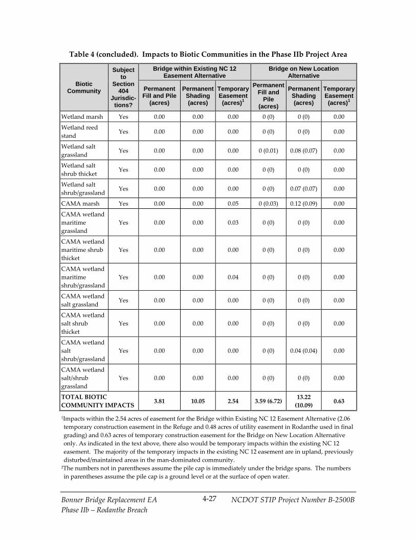
Bonner Bridge Replacement EA NCDOT STIP Project Number B‐2500B
Phase IIb – Rodanthe Breach
4‐27
Table 4 (concluded). Impacts to Biotic Communities in the Phase IIb Project Area
Biotic Community
Subject to
Section 404
Jurisdic-tions?
Bridge within Existing NC 12 Easement Alternative
Bridge on New Location Alternative
PermanentFill and Pile
(acres)
PermanentShading (acres)
TemporaryEasement (acres)1
PermanentFill and
Pile (acres)
Permanent Shading (acres)
TemporaryEasement (acres)1
Wetland marsh Yes 0.00 0.00 0.00 0 (0) 0 (0) 0.00
Wetland reed
stand Yes 0.00 0.00 0.00 0 (0) 0 (0) 0.00
Wetland salt
grassland Yes 0.00 0.00 0.00 0 (0.01) 0.08 (0.07) 0.00
Wetland salt
shrub thicket Yes 0.00 0.00 0.00 0 (0) 0 (0) 0.00
Wetland salt
shrub/grassland Yes 0.00 0.00 0.00 0 (0) 0.07 (0.07) 0.00
CAMA marsh Yes 0.00 0.00 0.05 0 (0.03) 0.12 (0.09) 0.00
CAMA wetland
maritime
grassland
Yes 0.00 0.00 0.03 0 (0) 0 (0) 0.00
CAMA wetland
maritime shrub
thicket
Yes 0.00 0.00 0.00 0 (0) 0 (0) 0.00
CAMA wetland
maritime
shrub/grassland
Yes 0.00 0.00 0.04 0 (0) 0 (0) 0.00
CAMA wetland
salt grassland Yes 0.00 0.00 0.00 0 (0) 0 (0) 0.00
CAMA wetland
salt shrub
thicket
Yes 0.00 0.00 0.00 0 (0) 0 (0) 0.00
CAMA wetland
salt
shrub/grassland
Yes 0.00 0.00 0.00 0 (0) 0.04 (0.04) 0.00
CAMA wetland
salt/shrub
grassland
Yes 0.00 0.00 0.00 0 (0) 0 (0) 0.00
TOTAL BIOTIC
COMMUNITY IMPACTS 3.81 10.05 2.54 3.59 (6.72)
13.22
(10.09) 0.63
1Impacts within the 2.54 acres of easement for the Bridge within Existing NC 12 Easement Alternative (2.06
temporary construction easement in the Refuge and 0.48 acres of utility easement in Rodanthe used in final
grading) and 0.63 acres of temporary construction easement for the Bridge on New Location Alternative
only. As indicated in the text above, there also would be temporary impacts within the existing NC 12
easement. The majority of the temporary impacts in the existing NC 12 easement are in upland, previously
disturbed/maintained areas in the man‐dominated community. 2The numbers not in parentheses assume the pile cap is immediately under the bridge spans. The numbers
in parentheses assume the pile cap is a ground level or at the surface of open water.

Bonner Bridge Replacement EA NCDOT STIP Project Number B‐2500B
Phase IIb – Rodanthe Breach
4‐28
With the Bridge within Existing NC 12 Easement Alternative, permanent impacts to
biotic communities would occur within the existing NC 12 easement. This alternative
would permanently impact 3.81 acres of biotic communities with fill and piles and
would shade another 10.05 acres. Of the 3.81 acres of permanent impacts,
approximately 75.1 percent (2.86 acres) would occur in man‐dominated areas. Of the
10.05 acres of shading impacts, 75.3 percent (7.57 acres) would occur in man‐dominated
areas.
Most of temporary impacts (total of 2.54 acres) are in upland (mainly grassland); 0.07
acre are in open water and 0.22 acre are in wetland.
With the Bridge on New Location Alternative, most of the permanent impacts to biotic
communities would occur outside of the existing NC 12 easement. This alternative
would permanently impact 3.59 acres of biotic communities with fill and piles and
would shade an additional 13.22 acres. The fill and pile impact of 3.59 acres assumes the
pile cap would be just under the bridge on new location spans (not in the water and
would not result in permanent impact), which was assumed in the 2010 EA in
calculating pile impacts for the Road North/Bridge South. The area of the bridge’s pile
caps is estimated to be 6.72 acres, which as indicated above would be a reasonable
representation of the fill and pile impact on land and in the sound if during final design,
the decision was made to place the pile cap at ground and water level. The larger fill
and pile impact would reduce the shading impact to 10.09 acres.
Of the permanent fill and pile impact of 3.59 acres, approximately 84.1 percent (3.02
acres) would occur in man‐dominated areas and 0.03 percent (0.11 acres) would occur in
open water. The 0.63 acre of temporary easement impacts to biotic communities would
occur within upland maritime grassland and upland maritime shrub/grassland.
4.2.5.3 Wetlands and Open Water Habitat
Given that the two detailed study alternatives are located similarly to their counterparts
in the 2008 FEIS and 2010 EA, their impacts to wetland and open water habitat would be
similar.
The Bridge within Existing NC 12 Easement Alternative would permanently impact 0.05
acre of wetlands and 0.02 acre of open waters (pool) with fill and pile; no wetlands or
open waters would be impacted by shading. This alternative would temporarily impact
0.01 acre of wetlands (maritime grassland) and 0.03 acre of open waters (pool). Neither
permanent nor temporary CAMA wetland impacts would occur.
The Bridge on New Location Alternative would permanently impact 0.44 acre of
wetlands and 0.11 acre of open waters with fill and pile. If the pile caps were placed at
ground or water level, this alternative would impact 0.52 acre of wetlands and 2.88 acres
of open water. Shading (the area of the bridge deck less the pile area) would affect 0.68
acre of wetlands and 11.23 acres of open water. If pile caps were placed on the ground
Bonner Bridge Replacement EA NCDOT STIP Project Number B‐2500B
Phase IIb – Rodanthe Breach
4‐29
or at water level, shading would affect 0.61 acre of wetlands and 8.46 acres of open
water). This alternative would permanently impact less than 0.01 acre of CAMA
wetlands with fill and pile (0.03 if using the larger pile cap area) and would shade 0.16
acre of CAMA wetlands (0.13 acre if using pile cap area). There would be no impact to
wetlands, including CAMA wetlands, from temporary fill.
4.2.5.4 Protected Species
Protected species and habitat for protected species addressed in the 2008 BA occur in the
Phase IIb project area. Descriptions and details on these species and associated habitat
are found in the 2008 FEIS (Section 4.7.9), the 2008 BA, as well as the 2013 technical
report on the Atlantic Sturgeon (CZR, Incorporated, 2013). Updated information is
found in the 2013 technical memorandum on threatened and endangered species for
Phase IIa (FHWA and NCDOT, 2013) and a similar document was prepared for Phase
IIb (FHWA and NCDOT, 2013). The current status of consultation under Section 7 of the
ESA of 1973 is described in Section 6.3.
Protected Species in an Aquatic Environment. The direct effects common to all sea
turtles identified in Section 7.2.1 of the 2008 BA remain applicable. The effects of noise,
lighting, and turbidity described in the 2008 BA for construction in Oregon Inlet also
would be applicable to the Phase IIb Bridge on New Location Alternative because this
alternative would include a bridge over Pamlico Sound, but because sea turtles occur
less frequently in the Bridge on New Location Alternative area, the chance of an effect is
less likely. There would be no dredging associated with in‐water construction with this
alternative. Shading and fill do not have a direct impact on sea turtles because they are
mobile organisms and can find other aquatic habitat.
Pamlico Sound open water habitats would be affected by jetting of piles with either
detailed study alternative. In the case of the Bridge on New Location Alternative, open
water habitats would be subject to jetting during construction; these effects would be
primarily short‐term and are not likely to adversely affect sea turtles. Jetting spoil
would be contained. For the Phase IIb Bridge within Existing NC 12 Easement
Alternative, NCDOT is planning to pump water from Pamlico Sound to the NC 12
easement to use in jetting piles. The pumping of water would be continuous while the
jetting equipment is running, and the volume of water needed to be pumped would be
about 1,000 to 1,500 gallons per minute. The internal diameter of the jetting pipes likely
would be about 2 to 2.5 inches and at least two pipes likely would be used. Turtles in
the water likely would avoid the area where the water is disturbed by the pumping of
water into the jetting pipes.
As documented in Appendix A of the 2008 BA for the Bridge within Existing NC 12
Easement Alternative (then the Phased Approach/Rodanthe Bridge Alternative), the
potential impacts with Phase IIb to sea turtles in the aquatic environment also would
occur when the Bridge within Existing NC 12 Easement Alternative bridge piles are in

Bonner Bridge Replacement EA NCDOT STIP Project Number B‐2500B
Phase IIb – Rodanthe Breach
4‐30
the ocean as a result of shoreline erosion. These impacts are highway run‐off and
predation on hatchlings by fish attracted to piling habitat.
The direct effects of the project on the shortnose sturgeon remain largely unchanged
from those listed in Section 8.2.1 of the 2008 BA and also would apply to the Atlantic
sturgeon. The effects of construction activities in Pamlico Sound with the Phase IIb
Bridge on New Location alternative would be similar to the effects of the construction of
the Phase I bridge over Oregon Inlet. Both would generate a short‐term localized
increase in noise, turbidity, and siltation. Again, there would be no dredging associated
with in‐water construction for Phase IIb, and NCDOT is planning to either pump water
from Pamlico Sound or jet piles in Pamlico Sound depending on the detailed study
alternative selected. However, the rarity of shortnose and Atlantic sturgeon in Albemarle
and Pamlico sounds, and their preference for deep spots during the day and tidal flats at
night in the summer and early fall (Jackson et al., 1992), makes the possibility that project
construction in Pamlico Sound would adversely affect this species discountable. In
addition, any occurrence of this species within the construction area likely would be short‐
term and in conjunction with annual spring migrations, further discounting the prospect
that project construction in Pamlico Sound would adversely affect these species. As was
indicated above for sea turtles, the Phase IIb Bridge on New Location Alternative would
permanently affect open water habitat in the Pamlico Sound by piles or shading
(including SAV). Piles would permanently occupy a discountable portion of the
potential soft‐bottom habitat for the shortnose and Atlantic sturgeon in Pamlico Sound.
Piles associated with the Bridge within Existing NC 12 Easement Alternative would
ultimately be in the Atlantic Ocean as a result of shoreline erosion. Sturgeon could be
affected by highway runoff with bridges over Pamlico Sound or the Atlantic Ocean.
Piles and highway runoff in either Pamlico Sound or the Atlantic Ocean are unlikely to
have any adverse effects on either of the two sturgeon species because they are mobile
organisms and can find other adjacent available aquatic habitat.
NMFS issued a letter on September 30, 2013 (see Appendix D of the Phase IIa ROD)
concluding formal consultation with FHWA on sea turtles and sturgeon. The focus of
the letter was on Oregon Inlet, where sea turtles and sturgeon are known to occur, and
the proposed Phase I replacement bridge over Oregon Inlet. The letter did not indicate
that a potential for impact to sea turtles or sturgeon existed for Phase IIb with either
detailed study alternative. Unlike the catwalks that provide fishing access at Oregon
Inlet, no fishing access facilities are planned as part of Phase IIb bridges.
The biological conclusion of May Affect, Not Likely to Adversely Affect for the Bonner
Bridge Replacement Project’s (B‐2500) PBC/TMP Alternative would not change because
of the characteristics of the Phase IIb alternatives.
Protected Species on Land. The Phase IIa and Phase I areas include beach habitat
suitable for nesting sea turtles. The Phase IIb project area also includes the same type of

Bonner Bridge Replacement EA NCDOT STIP Project Number B‐2500B
Phase IIb – Rodanthe Breach
4‐31
beach habitat. The effects of those projects and the PBC/TMP Alternative as a whole on
nesting sea turtles were described in the other the documents listed in the first
paragraph of this section. Because Phase IIb project impacts to sea turtles and their
habitat on land would be similar to those previously described in the other the
documents listed in the first paragraph of this section, there is no change in the effects
determinations for sea turtles for either Phase IIb detailed study alternative.
The Phase IIa and Phase I areas include habitat suitable for seabeach amaranth and the
effects of the projects on the plant and its habitat were described in the documents listed
in the first paragraph of this section. The Phase IIb project area also includes habitat
suitable for seabeach amaranth, and because the project impacts are similar to or less
than those previously evaluated in other documents, there is no change in the biological
conclusion of May Affect, Not Likely to Adversely Affect. The Phase IIb Bridge on New
Location Alternative would not have any impacts on the plant or its habitat because no
construction would occur on the beach. The Phase IIb Bridge within Existing Easement
would affect 0.01 acre beach habitat with fill and pile and 0.05 acre with temporary
impacts, and 0.25 acre of dune with fill and pile and 0.35 acre with temporary impacts.
An additional 1.09 acres of dune would be shaded by the bridge. Seabeach amaranth
has not been documented in the Phase IIb project area.
The Phase IIa area and the Phase I area include open water and adjacent shorelines that
include habitat suitable for piping plover nesting. The Phase IIb project area does not
include preferred nesting habitat. Monthly bird surveys have been conducted by
NCDOT biologists since January 2013. As of the date of this EA, no nests of piping
plover have been recorded in the Phase IIb area. While potential nesting and foraging
habitat has increased in the vicinity of the Pea Island inlet north of Phase IIb since the
2010 ROD, an incidental take of piping plover nests during construction would not
increase because no nests or nesting behavior have been documented near the Pea Island
inlet or the Phase IIb project area. Therefore, the biological conclusions for the piping
plover addressed in the 2008 BA and the Phase IIa EA also are assumed to remain
unchanged as a result of the Phase IIb alternatives.
4.2.5.5 Essential Fish Habitat
The potential impacts (short‐term, long‐term, permanent, and potential species‐specific)
to EFH addressed in the 2008 FEIS (Section 4.7.6.2) beginning on page 4‐104 and the
Essential Fish Habitat Assessment (CZR, Incorporated, 2008) as it relates to Phase I
(replacement of the Bonner Bridge) would be similar for the two detailed study
alternatives since both areas have the same EFH types. In addition, Phase I and the two
Phase IIb detailed study alternatives would involve the same type of activities in those
habitats. The Bridge on New Location Alternative, and to a lesser extent, the Bridge
within Existing NC 12 Easement Alternative, would affect EFH in Pamlico Sound. The
Bridge within Existing NC 12 Easement Alternative also would affect EFH once

Bonner Bridge Replacement EA NCDOT STIP Project Number B‐2500B
Phase IIb – Rodanthe Breach
4‐32
shoreline erosion results in the bridge being in the ocean. Permanent EFH impacts
would be the result of pile presence and bridge shading.
As indicated in Section 4.1.7, in general in the Phase IIb project area, waters less than 6
feet deep within Pamlico Sound are considered potential SAV habitat. Based on the
2012 aerial SAV mapping, all the open water of the Pamlico Sound crossed by the Phase
IIb Bridge on New Location Alternative contain either “patchy” or “sparse” SAV.
The pile impact to EFH and SAV habitat in Pamlico Sound (open water) would be 0.11
acre assuming the pile cap would be just under the bridge spans, which was assumed in
the 2010 EA in calculating pile impacts. The total area over the sound of the bridge’s
pile caps is estimated to be 2.88 acres, which although not set on the bottom, would be a
reasonable representation of the pile cap impact to EFH/SAV habitat if during final
design, the decision was made to place the pile cap at water level. The shading impact
(if the pile cap is placed directly under the bridge) to EFH/SAV habitat would be 11.23
acres. If 2.88 acres is the open water pile cap impact, the shading impact would be 8.46
acres. See the introduction to Section 4.2.5.2 for the reasons two different pile and
shading impacts are presented for the Bridge on New Location Alternative.
The bridge deck and pile presence impacts listed above would result in some loss of
EFH (under the piles) and in changes in light levels of the area underneath the bridge
and for some distance surrounding the bridge. These changes are expected to have a
minimal adverse effect on EFH, managed species, and SAV functions because of the
extensive distribution of SAV throughout the area and because the bridge would be over
15 feet above mean high water. SAV beds in this area are naturally patchy and function
as fragmented communities of varying density.
With the Bridge on New Location Alternative, temporary construction‐related impacts
on marine and estuarine waters could result from noise and turbidity, sediment
removal, and burial of organisms. Although some minor adverse impacts to EFH would
occur during the construction phases, the impacts would be temporary and are not
expected to result in significant short‐term or long‐term adverse effects on managed
species. A primary potential for construction impact within EFH for the Bridge on New
Location Alternative would be the pile jetting process, including increased turbidity and
burial of organisms by jetting spoil surrounding the pile being jetted into place. Jetting
uses high pressure water from pipes adjoining a pile to move the soil away from the tip
of the pile, allowing the pile to move into the hole created. When the high pressure
water is turned off, the surrounding soil settles around the pile. The soil that is
displaced by the pile is referred to as spoil. The water that is used in the jetting process
would come from the sound; as the USFWS and other agencies have previously
indicated, the placement of pipes and pumps associated with the jetting process cannot
be placed on the ocean beach. Depending upon the size of the pile and the depth at
which it needs to be placed, one bridge pile can be jetted into place in approximately 60

Bonner Bridge Replacement EA NCDOT STIP Project Number B‐2500B
Phase IIb – Rodanthe Breach
4‐33
minutes. Jetting operations likely would to occur over approximately half of the
construction period; and they would occur year round. Phase I of the PBC/TMP
Alternative also will involve jetting piles within EFH. A mitigation measure agreed to
with environmental resource and regulatory agencies in Phase I permit documents that
could be considered for the Bridge on New Location Alternative is minimizing turbidity
and water quality degradation by containment of the jetting spoil as a requirement in the
contractor’s contract. Primary and secondary containment systems could capture as
much of the jetting water as possible and re‐use it within the jetting operation in SAV
and wetland areas.
All spoil will be disposed of in an approved waste area. NCDOT will work with
NCDENR‐DCM, USFWS‐Refuge, and other agencies as needed on minimizing jetting
impacts to EFH, as well as jetting spoil disposal.
With the Bridge within Existing NC 12 Easement Alternative, jetting water would be
taken from the sound, likely at three locations, and would be transported through pipes
for use in jetting piles on land. This also will be done during the construction of the
Selected Alternative for the Phase IIa project. For the Phase IIa project, to minimize
impacts in the sound, a screen will be used on the intake of the jetting water pumping
operations to prevent the intake of larval species. Jetting spoils will be disposed of
within the NC 12 easement unless the Refuge accepts them for Refuge use. These
disposal measures also could apply to Phase IIb’s Bridge within Existing NC 12
Easement Alternative. There would be no other EFH impacts associated with the initial
construction of the Bridge within Existing NC 12 Alternative. Again, NCDOT will work
with NCDENR‐DCM, USFWS‐Refuge, and other agencies as needed on minimizing
jetting impacts to EFH, as well as jetting spoil disposal.
Impacts to EFH from Phase IIb’s Bridge within Existing NC 12 Easement Alternative
(plus any future phases involving a bridge in the existing NC 12 easement) would
eventually occur in the ocean as a result of shoreline erosion placing these alternatives in
the ocean. The impacts to EFH from bridge presence in the ocean are described in
Section 4.7.6.2 of the 2008 FEIS on page 4‐107. These impacts would include changes
related to water quality, water flow, sediment grain size and topography, bridge
shading, and potential long‐term impacts resulting from bridge maintenance activities
for portions of the bridge that over time would be located in the surf zone. A Bridge
within Existing NC 12 Easement Alternative would result in approximately 11.00 acres
of shading area over the Atlantic Ocean in 2060 as a result of shoreline erosion. There is
a potential to reduce habitat quality for larval and adult fish, as well as reduce
invertebrate species abundance and diversity. In addition, the introduction of bridge
piles would provide a type of hard substrate previously unavailable in the surf zone,
thereby increasing habitat complexity. Currently, the only wetland impact associated
with the Bridge within Existing NC 12 Easement Alternative would be 0.05 acre of
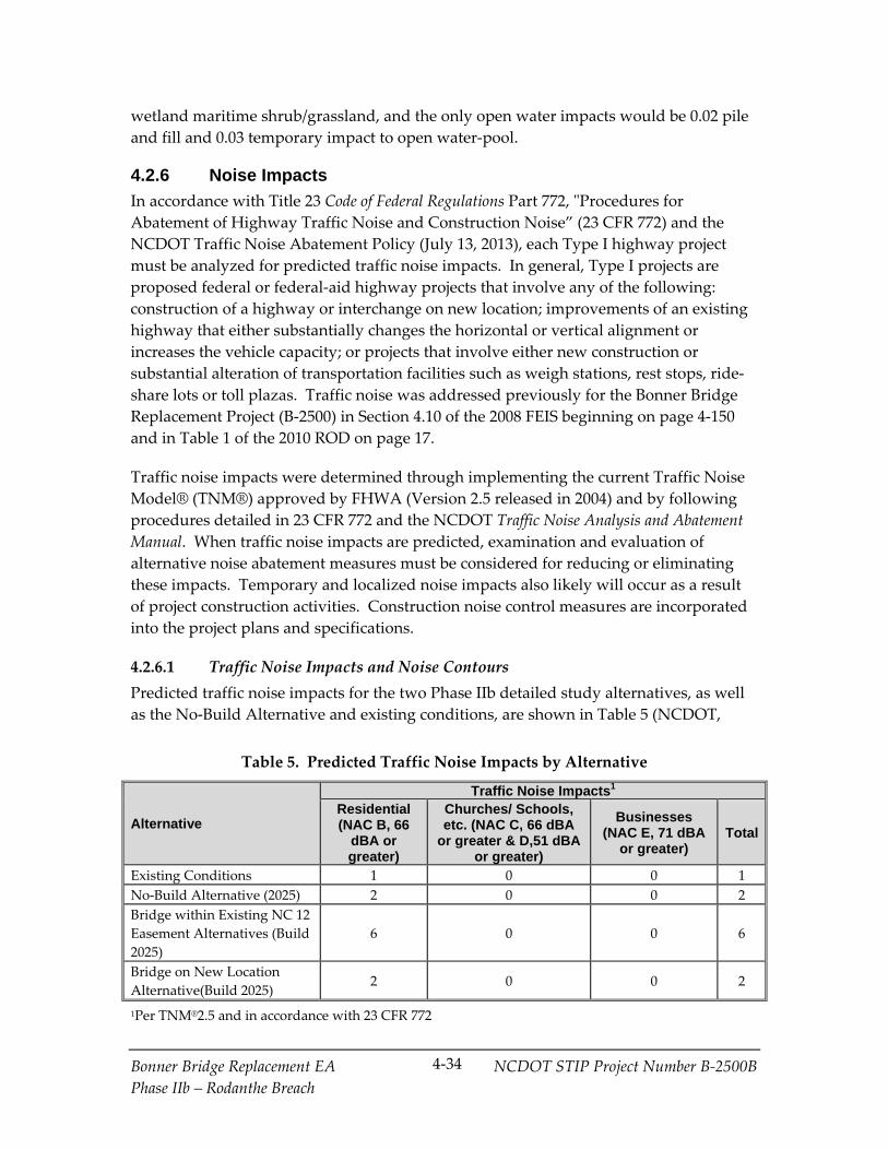
Bonner Bridge Replacement EA NCDOT STIP Project Number B‐2500B
Phase IIb – Rodanthe Breach
4‐34
wetland maritime shrub/grassland, and the only open water impacts would be 0.02 pile
and fill and 0.03 temporary impact to open water‐pool.
4.2.6 Noise Impacts
In accordance with Title 23 Code of Federal Regulations Part 772, ʺProcedures for
Abatement of Highway Traffic Noise and Construction Noise” (23 CFR 772) and the
NCDOT Traffic Noise Abatement Policy (July 13, 2013), each Type I highway project
must be analyzed for predicted traffic noise impacts. In general, Type I projects are
proposed federal or federal‐aid highway projects that involve any of the following:
construction of a highway or interchange on new location; improvements of an existing
highway that either substantially changes the horizontal or vertical alignment or
increases the vehicle capacity; or projects that involve either new construction or
substantial alteration of transportation facilities such as weigh stations, rest stops, ride‐
share lots or toll plazas. Traffic noise was addressed previously for the Bonner Bridge
Replacement Project (B‐2500) in Section 4.10 of the 2008 FEIS beginning on page 4‐150
and in Table 1 of the 2010 ROD on page 17.
Traffic noise impacts were determined through implementing the current Traffic Noise
Model® (TNM®) approved by FHWA (Version 2.5 released in 2004) and by following
procedures detailed in 23 CFR 772 and the NCDOT Traffic Noise Analysis and Abatement
Manual. When traffic noise impacts are predicted, examination and evaluation of
alternative noise abatement measures must be considered for reducing or eliminating
these impacts. Temporary and localized noise impacts also likely will occur as a result
of project construction activities. Construction noise control measures are incorporated
into the project plans and specifications.
4.2.6.1 Traffic Noise Impacts and Noise Contours
Predicted traffic noise impacts for the two Phase IIb detailed study alternatives, as well
as the No‐Build Alternative and existing conditions, are shown in Table 5 (NCDOT,
Table 5. Predicted Traffic Noise Impacts by Alternative
Alternative
Traffic Noise Impacts1 Residential (NAC B, 66
dBA or greater)
Churches/ Schools, etc. (NAC C, 66 dBA
or greater & D,51 dBA or greater)
Businesses (NAC E, 71 dBA
or greater) Total
Existing Conditions 1 0 0 1
No‐Build Alternative (2025) 2 0 0 2
Bridge within Existing NC 12
Easement Alternatives (Build
2025)
6 0 0 6
Bridge on New Location
Alternative(Build 2025) 2 0 0 2
1Per TNM®2.5 and in accordance with 23 CFR 772

Bonner Bridge Replacement EA NCDOT STIP Project Number B‐2500B
Phase IIb – Rodanthe Breach
4‐35
2013b). The Table 5 findings take into consideration the potential for receptors (persons
standing outside) to experience traffic noise impacts by either approaching or exceeding
the FHWA noise abatement criteria (NAC) or by a substantial increase in exterior noise
levels as defined in the NCDOT Traffic Noise Abatement Policy, for any activity
category listed in Table 6. All the impacts indicated in Table 5 result from traffic noise
impacts that approach (1 dB(A) below the NAC criteria) or exceed the NAC. For the
existing condition, one residential noise receptor was predicted to approach or exceed
the FHWA NAC for Activity Category B.
As shown in Table 1 of the 2010 ROD (page 17), the Road North/Bridge South
Alternative would have resulted in three residential noise receptors that approach or
exceed the FHWA NAC for Activity Category B; substantial noise increases would have
occurred at an additional three residential receptors (including one of the three that
exceeds the FHWA NAC for Activity Category B) and 1 business noise receptor
(Activity Category E). As indicated in Table 5 above, the equivalent Bridge on New
Location Alternative would result in two residential noise receptors that approach or
exceed the FHWA NAC for Activity Category B; a substantial increase in noise levels
between the existing condition and the design year is not predicted for any noise
receptor. Therefore, the Bridge on New Location alternative has a lower traffic noise
impact than the Road North/Bridge South Alternative included in the 2010 ROD.
As shown in Table 1 of the 2010 ROD (page 17), the Phased Approach/Rodanthe Bridge
Alternative would have resulted in three residential noise receptors that approach or
exceed the FHWA NAC for Activity Category B. As indicated in Table 5 above, the
equivalent Bridge within Existing NC 12 Easement Alternative would result in six
residential noise receptors that approach or exceed the FHWA NAC for Activity
Category B. This higher traffic noise impact is likely the result of changes in the specific
homes displaced, including homes formally displaced that now have noise impacts. No
substantial increases in noise levels would occur at any receptors with either the Bridge
within Existing NC 12 Easement Alternative or its equivalent in the 2010 ROD.
The maximum extent of the 71 and 66 dB(A)4 noise level contours5 measured from the
center of the proposed roadway is less than 20 and 56 feet, respectively, for the Bridge
within Existing NC 12 Easement Alternative. The maximum extent of the 71 and 66
4 dB stands for decibel. The A‐weighted sound level is a measure of sound intensity with
frequency characteristics that correspond to human subjective response to noise. For more detail,
see the 2008 FEIS, Section 3.10.1.4 on page 3‐112. 5 The 71 and 66 dB(A) noise contours are lines that illustrate the distance from each detailed study
alternative where the noise levels of 71 and 66 dB(A) are expected to occur, and corresponds to
the NAC for Activity Category E and B/C receptors, respectively.

Bonner Bridge Replacement EA NCDOT STIP Project Number B‐2500B
Phase IIb – Rodanthe Breach
4‐36
Table 6. Noise Abatement Criteria Noise Abatement Criteria
(Hourly Equivalent A‐Weighted Sound Level Decibels – dB(A))
Activity Category
Activity Criteria1 Leq(h)2
Evaluation Location
Activity Description
A 57 Exterior
Lands on which serenity and quiet are of extraordinary
significance and serve an important public need and where the
preservation of those qualities is essential if the area is to
continue to serve its intended purpose.
B3 67 Exterior Residential
C3 67 Exterior
Active sport areas, amphitheaters, auditoriums, campgrounds,
cemeteries, daycare centers, hospitals, libraries, medical
facilities, parks, picnic areas, places of worship, playgrounds,
public meeting rooms, public or nonprofit institutional
structures, radio studios, recording studios, recreation areas,
Section4(f) sites, schools, television studios, trails, and trail
crossings.
D 52 Interior
Auditoriums, day care centers, hospitals, libraries, medical
facilities, places of worship, public meeting rooms, public or
nonprofit institutional structures, radio studios, recording
studios, schools, and television studios.
E 72 Exterior Hotels, motels, offices, restaurants/bars, and other developed
lands, properties, or activities not included in A‐D or F.
F ‐‐ ‐‐
Agriculture, airports, bus yards, emergency services, industrial,
logging maintenance facilities, manufacturing, mining, rail
yards, retail facilities, shipyards, utilities (water resources,
water treatment, electrical), and warehousing.
G ‐‐ ‐‐ Undeveloped lands that are not permitted.
Source: NCDOT Traffic Noise Abatement Policy, effective July 20, 2011. 1The Leq(h) activity criteria values are for impact determination only, and are not design
standards for noise abatement measures. 2The equivalent steady‐state sound level which in a stated period of time contains the same
acoustic energy as the time‐varying sound level during the same time period, with Leq(h) being
the hourly value of Leq. 3Includes undeveloped lands permitted for this activity category.
Bonner Bridge Replacement EA NCDOT STIP Project Number B‐2500B
Phase IIb – Rodanthe Breach
4‐37
dB(A) noise level contours measured from the center of the proposed roadway is 20 feet
and 75 feet, respectively for the Bridge on New Location Alternative.
4.2.6.2 No‐Build Alternative Traffic Noise
The traffic noise analysis also considered traffic noise impacts for the No‐Build
Alternative. If the proposed Phase IIb project is not built, two receptors are predicted to
experience traffic noise impacts, and the future traffic noise levels will increase by
approximately 3 dB(A). Based upon research, humans barely detect noise level changes
of 2 to 3 dB(A). A 5 dB(A) change is more readily noticeable. Therefore, most people
working and living near NC 12 would not notice this predicted increase.
4.2.6.3 Traffic Noise Abatement Measures
Measures for reducing or eliminating the traffic noise impacts were considered for all
impacted receptors of each alternative. The primary noise abatement measures
evaluated for highway projects include highway alignment changes, traffic system
management measures, establishment of buffer zones, noise barriers, and noise
insulation (Activity Category D only). For each of these measures, benefits versus
allowable abatement measure quantity (reasonableness), engineering feasibility,
effectiveness and practicability and other factors are included in the noise abatement
considerations.
A highway alignment change is the only viable noise abatement measure of those listed
in the previous paragraph. Highway alignment changes for traffic noise abatement
involve modifying the alignment of a proposed road to minimize traffic noise at noise
sensitive receptors. The selection of alternative alignments for noise abatement
purposes must consider the balance between noise impacts and other engineering and
environmental parameters. The Bridge on New Location Alternative reflects a viable
option for locating the highway alignment to minimize noise impact, reducing impacts
from six receptors (with the Bridge within Existing NC 12 Easement Alternative) to two
receptors.
Traffic system management measures such as banning truck traffic, limiting times of
operation, or lowering the speed limit are not considered viable options since NC 12 is
the only through route on Hatteras Island. Costs to acquire buffer zones (essentially
displacing the impacted receptors) would exceed the NCDOT base quantity value of
$37,500 per benefited receptor, causing this abatement measure to be unreasonable.
Noise barriers include two basic types: earthen berms and noise walls. These structures
act to diffract, absorb, and reflect highway traffic noise. This project would remain an
uncontrolled right‐of‐way access road, meaning that most noise‐sensitive land uses
would have direct access connections to the proposed project, and intersections would
adjoin the project at grade. The traffic noise analysis confirmed that because regular
breaks would be required for driveways and street intersections, any potential noise
Bonner Bridge Replacement EA NCDOT STIP Project Number B‐2500B
Phase IIb – Rodanthe Breach
4‐38
barriers would not be reasonable or feasible as defined by the noise abatement measure
feasibility criteria of the NCDOT Traffic Noise Abatement Policy.
4.2.6.4 Traffic Noise Summary
The Bridge within Existing NC 12 Easement Alternative would result in six residential
noise receptor impacts compared to two for the Phased Approach/Rodanthe Bridge
Alternative. This is likely the result of changes in the specific homes displaced,
including homes formally displaced that now have noise impacts. The Bridge on New
Location Alternative would result in one less residential noise receptor impact (two
instead of three) compared to the Road North/Bridge South Alternative, and no
substantial noise level increases (compared to three substantial noise level increases for
the Road North/Bridge South Alternative).
Based on this preliminary study, traffic noise abatement is not recommended and no
noise abatement measures are proposed. This evaluation completes the highway traffic
noise requirements of 23 CFR 772. No additional noise analysis will be performed for
this project unless warranted by a substantial change in the project scope, vehicle
capacity, or alignment.
In accordance with NCDOT Traffic Noise Abatement Policy, the federal and North
Carolina governments are not responsible for providing noise abatement measures for
new development for which building permits are issued after the Date of Public
Knowledge. The Date of Public Knowledge of the proposed highway project will be the
approval date of the Record of Decision (ROD). For development occurring after this
date, local governing bodies are responsible to insure that noise compatible designs are
used along the proposed project.
4.2.6.5 Construction Noise
Construction noise was addressed in Section 4.13.3 of the 2008 FEIS beginning on page
4‐173. Compared to the Bridge on New Location Alternative, the Bridge within Existing
NC 12 Easement Alternative would have greater construction noise impacts on daily
activities in Rodanthe because construction would occur within Rodanthe, adjacent to
the numerous homes and businesses lining NC 12. Except where it reaches the shore
and enters Rodanthe, construction activities for the Bridge on New Location Alternative
would be approximately 1,200 to 2,500 feet from the soundside shoreline and the homes
located along the shoreline. In addition, the Bridge within Existing NC 12 Easement
Alternative would have a greater construction noise impact on the Refuge because it is
within the Refuge and not primarily offshore in the sound like the Bridge on New
Location Alternative.
The predominant construction activities associated with this project are expected to be
pile driving, impact hammers (jack hammer, hoe‐ram), earth removal, hauling, grading,
Bonner Bridge Replacement EA NCDOT STIP Project Number B‐2500B
Phase IIb – Rodanthe Breach
4‐39
and paving. Temporary and localized construction noise impacts likely will occur as a
result of these activities.
During daytime hours, the predicted effects of construction activities would be
temporary speech interference for passers‐by and those individuals living or working
near the project. During evening and nighttime hours, steady‐state construction noise
emissions, such as from paving operations would be audible, and could cause impacts to
activities such as sleep. Sporadic evening and nighttime construction equipment noise
emissions such as from backup alarms, lift gate closures (“slamming” of dump truck
gates), etc., would be perceived as distinctly louder than the steady‐state acoustic
environment, and would likely cause severe impacts to the general peace and usage of
noise sensitive areas – particularly residences.
Extremely loud construction noise activities such as the use of pile‐drivers and impact
hammers would provide sporadic and temporary construction noise impacts in the near
vicinity of those activities. Such an impact could be mitigated by scheduling
construction activities that would produce extremely loud noises during times of the
day when such noises would create as minimal disturbance as possible.
Generally, low‐cost and easily implemented construction noise control measures could
be incorporated into the project plans and specifications to the extent possible. These
measures include, but are not limited to, work‐hour limits, equipment exhaust muffler
requirements, haul road locations, elimination of “tail gate banging”, ambient‐sensitive
backup alarms, construction noise complaint mechanisms, and consistent and
transparent community communication.
4.2.7 Air Quality Impacts
Air quality impacts of the Bonner Bridge Replacement Project (B‐2500) were assessed in
Section 4.9 of the 2008 FEIS beginning on page 4‐141. That assessment concluded that
the proposed project would not cause or exacerbate a violation of National Ambient Air
Quality Standards (NAAQS), as established by the Clean Air Act of 1970 as amended. It
further concluded that the Bonner Bridge Replacement Project (B‐2500) conforms to the
State Implementation Plan (SIP) and the goals set forth in the Clean Air Act
Amendments (CAAA) and the Final Conformity Rule. It further concluded notable
changes in the emissions of Mobile Source Air Toxics (MSATs) are not expected. An
updated project‐level qualitative air quality analysis was prepared for Phase IIb
(NCDOT, September 20, 2013). This assessment of air quality impacts follows air quality
assessment procedures as they relate to determining compliance with NAAQS and
considering MSAT. No notable new air quality impacts were found. Specific findings of
the new qualitative air quality assessment for Phase IIb are presented in the following
sections.

Bonner Bridge Replacement EA NCDOT STIP Project Number B‐2500B
Phase IIb – Rodanthe Breach
4‐40
4.2.7.1 Attainment Status
The project is in Dare County, which complies with NAAQS. The Phase IIb project will
not add substantial new capacity or create a facility that is likely to meaningfully
increase emissions. Therefore, it is not anticipated to create any adverse effects on the
air quality of this attainment area.
4.2.7.2 Mobile Source Air Toxics (MSAT)
Controlling air toxic emissions became a national priority with the passage of the Clean
Air Act Amendments (CAAA) of 1990, whereby Congress mandated that the USEPA
regulate 188 air toxics. The USEPA rule on the Control of Hazardous Air Pollutants
from Mobile Sources (Federal Register, Vol. 72, No. 37, page 8430, February 26, 2007)
requires controls that will dramatically decrease MSAT emissions of motor vehicles
through cleaner fuels and cleaner engines. Based on a FHWA analysis using USEPAʹs
MOVES2010b motor vehicle emissions model (October 30, 2012), even if vehicle‐miles
traveled (VMT) increase by 102 percent (as assumed nationally from 2010 to 2050), a
combined reduction of 83 percent in the total annual emissions for the priority MSAT is
projected for the same time period.
The FHWA developed a tiered approach with three categories for analyzing MSAT in
NEPA documents, depending on specific project circumstances:
1. No analysis for projects with no potential for meaningful MSAT effects;
2. Qualitative analysis for projects with low potential MSAT effects; or
3. Quantitative analysis to differentiate alternatives for projects with higher potential
MSAT effects.
The Phase IIb project falls under Category 2 because it is intended to improve the
operations of a highway, transit, or freight without adding substantial new capacity or
without creating a facility that is likely to meaningfully increase emissions, and because
the design year traffic is not projected to meet or exceed the 140,000 to 150,000 AADT
criterion.
Qualitative MSAT Analysis. For Category 2 projects, a qualitative assessment of
emissions projections is conducted. A qualitative MSAT analysis provides a basis for
identifying and comparing the potential differences among MSAT emissions, if any,
from the various alternatives. For each alternative in this EA, the amount of MSAT
emitted would be proportional to the vehicle miles traveled, or VMT, assuming that
other variables such as fleet mix are the same for the alternative. Average daily VMT in
the Phase IIb project area is shown in Table 7.
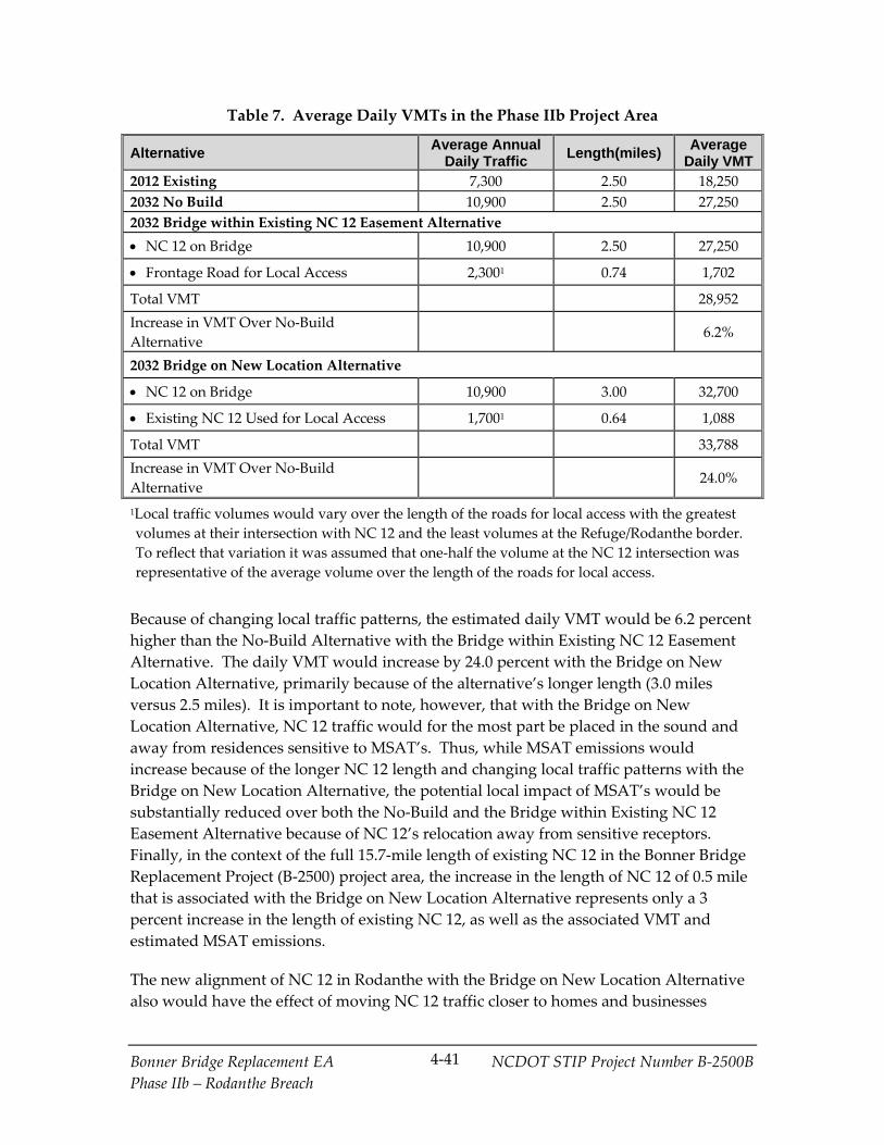
Bonner Bridge Replacement EA NCDOT STIP Project Number B‐2500B
Phase IIb – Rodanthe Breach
4‐41
Table 7. Average Daily VMTs in the Phase IIb Project Area
Alternative Average Annual
Daily Traffic Length(miles)
Average Daily VMT
2012 Existing 7,300 2.50 18,250
2032 No Build 10,900 2.50 27,250
2032 Bridge within Existing NC 12 Easement Alternative
NC 12 on Bridge 10,900 2.50 27,250
Frontage Road for Local Access 2,3001 0.74 1,702
Total VMT 28,952
Increase in VMT Over No‐Build
Alternative 6.2%
2032 Bridge on New Location Alternative
NC 12 on Bridge 10,900 3.00 32,700
Existing NC 12 Used for Local Access 1,7001 0.64 1,088
Total VMT 33,788
Increase in VMT Over No‐Build
Alternative 24.0%
1Local traffic volumes would vary over the length of the roads for local access with the greatest
volumes at their intersection with NC 12 and the least volumes at the Refuge/Rodanthe border.
To reflect that variation it was assumed that one‐half the volume at the NC 12 intersection was
representative of the average volume over the length of the roads for local access.
Because of changing local traffic patterns, the estimated daily VMT would be 6.2 percent
higher than the No‐Build Alternative with the Bridge within Existing NC 12 Easement
Alternative. The daily VMT would increase by 24.0 percent with the Bridge on New
Location Alternative, primarily because of the alternative’s longer length (3.0 miles
versus 2.5 miles). It is important to note, however, that with the Bridge on New
Location Alternative, NC 12 traffic would for the most part be placed in the sound and
away from residences sensitive to MSAT’s. Thus, while MSAT emissions would
increase because of the longer NC 12 length and changing local traffic patterns with the
Bridge on New Location Alternative, the potential local impact of MSAT’s would be
substantially reduced over both the No‐Build and the Bridge within Existing NC 12
Easement Alternative because of NC 12’s relocation away from sensitive receptors.
Finally, in the context of the full 15.7‐mile length of existing NC 12 in the Bonner Bridge
Replacement Project (B‐2500) project area, the increase in the length of NC 12 of 0.5 mile
that is associated with the Bridge on New Location Alternative represents only a 3
percent increase in the length of existing NC 12, as well as the associated VMT and
estimated MSAT emissions.
The new alignment of NC 12 in Rodanthe with the Bridge on New Location Alternative
also would have the effect of moving NC 12 traffic closer to homes and businesses

Bonner Bridge Replacement EA NCDOT STIP Project Number B‐2500B
Phase IIb – Rodanthe Breach
4‐42
between the sound and its intersection with NC 12, the southern terminus. The Bridge
within Existing NC 12 Easement Alternative would bring traffic closer to the upper story
living areas of homes along NC 12 and local traffic on at‐grade frontage roads closer to
the same homes. Therefore, under each alternative there may be localized areas where
ambient concentrations of MSAT could be higher.
Regardless of the alternative chosen, emissions will likely be lower than present levels in
the design year as a result of USEPAʹs national control programs that are projected to
reduce annual MSAT emissions by over 80 percent from 2010 to 2050. Local conditions
may differ from these national projections in terms of fleet mix and turnover, VMT
growth rates, and local control measures. However, the magnitude of the USEPA‐
projected reductions is so great (even after accounting for VMT growth) that MSAT
emissions in the Phase IIb project area are likely to be lower in the future in virtually all
locations.
Incomplete or Unavailable Information for Project‐Specific MSAT Health Impacts
Analysis. In FHWAʹs view, information is incomplete or unavailable to credibly predict
the project‐specific health impacts that would result from changes in MSAT emissions
associated with a proposed set of highway alternatives. The outcome of such an
assessment, adverse or not, would be influenced more by the uncertainty introduced
into the process through assumption and speculation rather than any genuine insight
into the actual health impacts directly attributable to MSAT exposure associated with a
proposed action. Further, because of the limitations in the methodologies for forecasting
health impacts, any predicted difference in health impacts between the detailed study
alternatives is likely to be much smaller than the uncertainties associated with predicting
the impacts. Consequently, the results of such assessments would not be useful to
decision makers, who would need to weigh this information against project benefits.
4.2.7.3 Construction Air Quality
The 2008 FEIS addressed construction‐related impacts on air quality in Section 4.13.2
(page 4‐173). Air quality impacts resulting from roadway construction activities are
typically not a concern when contractors utilize appropriate control measures. During
construction of the proposed project, all materials resulting from clearing and grubbing
(removing plant roots), demolition, or other operations would be removed, burned, or
otherwise disposed of by the contractor. Any burning done would be done in
accordance with applicable local laws and ordinances and regulations of the North
Carolina SIP for air quality in compliance with 15 NCAC 2D.0520. Care would be taken
to ensure burning would be done at the greatest distance practicable from dwellings,
and would not be done when atmospheric conditions are such as to create a hazard to
the public. Operational agreements that would reduce or redirect work or shift times to
avoid community exposures can reduce this impact. Burning would be performed
under constant surveillance. Also during construction, measures would be taken to
Bonner Bridge Replacement EA NCDOT STIP Project Number B‐2500B
Phase IIb – Rodanthe Breach
4‐43
reduce the dust generated by construction when the control of dust is necessary for the
protection and comfort of motorists or area residents.
4.3 Effect of the Phase IIb Detailed Study Alternatives on the PBC/TMP Alternative
Changes since the findings of the 2010 ROD based on the above analysis of the Phase IIb
detailed study alternatives are primarily associated with minor changes in the
characteristics of the project area and refinements to the 2010 designs of the two detailed
study alternatives. Changes in the characteristics of the Phase IIb project area resulted in
the following effects:
Updates to the forecast 2060 high‐erosion shoreline, with reduced potential erosion
(see Appendix D).
Altering the location of Hatteras Island habitat types.
Hurricane Irene in August 2011 or Hurricane Sandy in October 2012 introduced few
changed environmental elements to the Phase IIb project area. Beach erosion was
associated with both storms. Beach erosion is taken into consideration in the 2008 FEIS
and subsequent environmental documentation. Hurricane Irene created a breach, which
was closed by NCDOT. The 2008 FEIS and subsequent environmental documentation
take into consideration the potential for a breach in the Rodanthe area.
The design characteristics of the Phase IIb detailed study alternatives would be similar
to what was defined in the 2008 FEIS (as updated in the 2010 EA) as the Bridge South
component of the Road North/Bridge South Alternative (a bridge in the sound), and a
portion of Phase II of the Phased Approach/Rodanthe Bridge Alternative (a bridge
within the existing NC 12 easement). The minimal differences between the designs of
the two bridge alternatives are described in Sections 2.4.2 and 2.4.3 of this EA.
4.3.1 Updated Impacts in the Phase IIb Area
The above changes in the setting and design introduced the following notable changes
in potential impacts:
Reduced residential and business relocations.
Lessened, but still sizable, visual impacts on the Refuge. Phase IIb bridge height was
re‐evaluated during design of the Phase IIb detailed study alternatives (see Section
4.2.1) and is now lower than in the 2008 FEIS. Visual impacts contribute to the
conclusion that the Phase IIb detailed study alternatives would have an Adverse
Effect on the Refuge as a historic resource.

Bonner Bridge Replacement EA NCDOT STIP Project Number B‐2500B
Phase IIb – Rodanthe Breach
4‐44
Need for easements, including with the Bridge within Existing NC 12 Easement
Alternative 2.5 acres of utility easement (0.48 acres of which also will be used for
final grading) in Rodanthe and 2.06 acres of temporary contruction easement in the
Refuge and with the Bridge on New Location Alternative 0.63 acre of temporary
construction easement in the Refuge.
Lower noise impacts than presented in the 2010 ROD for the Bridge on New
Location Alternative (Road North/Bridge South in the 2010 ROD) and higher
impacts with the Bridge within Existing NC 12 Easement Alternative (Phased
Approach/Rodanthe Bridge in the 2010 ROD). The higher impact is likely the result
of changes in the specific homes displaced, including homes formally displaced that
now have noise impacts.
4.3.2 Updated Costs
Phase IIb detailed study alternatives are expected to cost $187.5 to $215.5 million for the
Bridge within Existing NC 12 Easement Alternative and $203.3 to $236.3 million for the
Bridge on New Location Alternative. Details on the costs are shown in Table 1. Both
detailed study alternatives are similar to alternatives assessed in the 2008 FEIS (as
updated in the 2010 EA). Neither the Phase IIb setting nor design for the detailed study
alternatives changed substantially since 2010 and thus, did not notably affect the overall
cost of the PBC/TMP Alternative. Thus, no notable changes to the overall cost of the
PBC/TMP are expected.
4.3.3 Impact of Implementation of All Phases of the PBC/TMP Alternative
This section addresses how the implementation of either one of the Phase IIb detailed
study alternatives would affect the potential total impact of all phases of the PBC/TMP
Alternative. The construction of either one of the Phase IIb detailed study alternatives
would have no potential effect on the environmental impacts of the implementation of
all phases of the PBC/TMP Alternative (selected for implementation in the 2010 ROD)
because both their southern and northern endpoints connect to a portion of existing
NC 12 for which no changes are planned or expected to be needed prior to 2060, The
northern terminus of both alternatives connects to a portion of NC 12 in the Refuge that
is not threatened by shoreline erosion prior to 2060 and where the island is not
susceptible to breaching. The southern terminus of both alternatives is at the southern
end of the Bonner Bridge Replacement Project (B‐2500) project area. Thus, because there
is no direct connection between Phase IIb and the locations where future phases of the
PBC/TMP alternative would occur, the selection of either Phase IIb detailed study
alternative would place no limits on the choices available for other future phases of the
PBC/TMP alternative, including the use of nourishment, road on new location, bridge on
new location, and bridge within the existing easement.

Bonner Bridge Replacement EA NCDOT STIP Project Number B‐2500B
Phase IIb – Rodanthe Breach
4‐45
In general, the PBC/TMP Alternative as described in the 2010 ROD calls for the study
and selection of future actions on Hatteras Island beyond the limits of Phase I, and now
beyond Phase II, through a comprehensive NC 12 Transportation Management Plan.
This approach takes into account the inherent uncertainty in predicting future
conditions within the dynamic coastal environment. The PBC/TMP Alternative and the
components of its comprehensive NC 12 Transportation Management Plan are described
in Section 1.2. The implementation of plan components began in early 2011 and will
continue until the PBC/TMP Alternative is completed.
Based on the above considerations, as well as the findings of Section 4.3.1, the expected
nature and extent of environmental impacts of the potential future phases of the
PBC/TMP Alternative are not expected to change with the implementation of either of
one the Phase IIb detailed study alternatives.
4.4 Phase IIb Permits and Approvals
Construction of either one of the Phase IIb detailed study alternatives would require the
permits and approvals listed below (with some differences between the two detailed
study alternatives). Federal funding for this project is expressly conditioned upon
compliance with all permitting terms and conditions.
US Coast Guard Permit
Under the authority of Section 9 of the Rivers and Harbors Act of 1899 and the General
Bridge Act of 1946 (as well as other legislation), the US Coast Guard (USCG) is
responsible for approving the locations and plans for bridges and causeways over
navigable waterways. NCDOT anticipates a USCG Permit under Title 33, Section 115.50
of the Code of Federal Regulations will be required for the bridge over Pamlico Sound with
the Bridge on New Location Alternative. This permit would not be needed for the
Bridge within Existing NC 12 Easement Alternative.
US Army Corps of Engineers Permits
Under Section 404 of the Clean Water Act, USACE is responsible for issuing permits for
discharges of dredged or fill material in waters of the United States, including fill placed
in connection with bridge and road construction and the disposal of construction debris.
The anticipated impacts to wetlands as a result of construction of the detailed study
alternatives are discussed in Section 4.1.5.
US Fish and Wildlife Service Permits and Approvals
A special use permit would be required for the temporary construction easements
necessary to construct either detailed study alternative and the new permanent
easement associated with the Bridge on New Location Alternative. The exact terms and
conditions, as well as appropriate compensatory mitigation, will be determined during
the permitting process.
Bonner Bridge Replacement EA NCDOT STIP Project Number B‐2500B
Phase IIb – Rodanthe Breach
4‐46
US Park Service Permits and Approvals
A special use permit could be required for the temporary construction easement and the
new permanent easement necessary to construct the Bridge within Existing NC 12
Easement Alternative because this alternative is near the ocean just north of Rodanthe
and could be outside USFWS jurisdiction but within NPS jurisdiction. The exact terms
and conditions, as well as appropriate compensatory mitigation, will be determined
during the permitting process.
Coastal Area Management Act Permit
A CAMA permit is required from NCDENR‐DCM since either alternative would
involve construction in AEC.
NCDENR‐Division of Water Quality Certification
A 401 Water Quality Certification (as mandated under Section 401 of the Clean Water
Act) would be required from NCDENR‐DWR. The 401 certification process is
coordinated with the 404 and CAMA processes and would be required with either
detailed study alternative.
NCDENR‐Division of Water Quality Stormwater Permit
Effective August 1, 2013, NCDOT is no longer required to submit State Stormwater
permit applications for projects discharging stormwater runoff in High Quality Waters
(HQW) and Outstanding Resource Waters (ORW) watersheds, because NCDOT is
regulated under its National Pollutant Discharge Elimination System (NPDES) permit.
Other Permitting/Approval Actions and Consultations
FHWA and NCDOT will continue to coordinate with the permitting agencies
throughout the Phase IIb final design and permitting process and during construction.
FHWA also will coordinate with USFWS and NMFS on any Section 7 of the ESA of 1973
concerns that arise during final design and construction; consultation under Section 7
will be re‐initiated with either of these agencies if it becomes necessary. FHWA and
NCDOT also will carry out the stipulations of the Section 106 National Historic
Preservation Act Programmatic Agreement (Appendix E of the Phase IIa ROD) and will
coordinate with the other Signatory and Concurring Parties, as necessary, during the
final design, permitting, and construction processes.

Bonner Bridge Replacement EA NCDOT STIP Project Number B‐2500B
Phase IIb – Rodanthe Breach
5‐1
5.0 Section 4(f) Evaluation for Phase IIb
The purpose of this chapter is to assess whether the detailed study alternatives being
considered for Phase IIb of the Bonner Bridge Replacement Project (B‐2500) in the
Rodanthe area affects the findings of the October 2009 Revised Final Section 4(f)
Evaluation (Revised 4(f) Evaluation) related to the entire PBC/TMP Alternative, by
determining if the Phase IIb detailed study alternatives, including the Preferred
Alternative, would use Section 4(f) property and providing the information and analysis
necessary for FHWA to approve any such use. The Revised 4(f) Evaluation was
included in the 2010 EA as Appendix B, and its findings are summarized below in
Section 5.1. The Phase IIb detailed study alternatives are described in Section 5.2.
Section 4(f) of the USDOT Act of 1966, as amended (49 U.S.C. § 303), states that USDOT
may not approve the use of land from a significant publicly owned park, recreation area,
or wildlife and waterfowl refuge, or any significant historic site, unless a determination
is made that the project will have a de minimis impact, or unless a determination is made
that:
1. There is no feasible and prudent avoidance alternative, as defined in 23 CFR 774.17,
to the use of land from the property; and
2. The action includes all possible planning, as defined in 23 CFR 774.17, to minimize
harm to the property resulting from such use.
The following sections are included in this chapter:
October 2009 Revised Final Section 4(f) Evaluation Findings
Proposed Detailed Study Alternatives for
Phase IIb
Section 4(f) Properties in the Phase IIb Project Area
Impact to Section 4(f) Properties
Analysis of Avoidance Alternatives
Effect on the Least Harm Analysis
Effect on All Possible Planning to Minimize Harm

Bonner Bridge Replacement EA NCDOT STIP Project Number B‐2500B
Phase IIb – Rodanthe Breach
5‐2
5.1 October 2009 Revised Final Section 4(f) Evaluation Findings as Updated in the Phase IIa EA
As discussed in Section 4.0 of the 2010 ROD, the Revised 4(f) Evaluation determined that
all six of the Parallel Bridge Corridor alternatives, including the PBC/TMP Alternative,
would require a use of the Refuge. The Refuge qualifies as a Section 4(f) property
because it is a wildlife refuge and a historic site that is eligible for the NRHP. The
Revised 4(f) Evaluation concluded that Section 4(f) applies to the Refuge as a historic
property (see pages 8 to 15 of the Revised 4(f) Evaluation [pages B‐8 to B‐15 of 2010 EA,
Appendix B]). The Revised 4(f) Evaluation determined that Phase I would use
approximately 3.2 acres of Refuge land. In addition, it was determined that for future
phases, all of the Parallel Bridge Corridor alternatives considered may have a use of
Refuge lands (see Table 1 of the 2010 ROD).
The Revised 4(f) Evaluation also determined that all six of the Parallel Bridge Corridor
alternatives, including the PBC/TMP Alternative, would use approximately 6.3 acres
from the Seashore, but that Section 4(f) is not applicable to this impact because the road
[now called NC 12] was concurrently and jointly planned and developed with the
establishment of the Seashore (see page B‐12 of the Revised Section 4(f) Evaluation in
Appendix B of the 2010 EA).
In addition to reaching the conclusions noted above, the Revised 4(f) Evaluation
identified the location and characteristics of the Section 4(f) properties in the project
area, described the applicability of Section 4(f) to these properties, discussed avoidance
alternatives, presented a least overall harm analysis, and addressed the measures taken
to minimize harm.
Based upon the Revised 4(f) Evaluation, FHWA determined in the 2010 ROD that there
was no feasible and prudent alternative to the use of land from the Pea Island National
Wildlife Refuge for the construction of Phase I of the project, and that the PBC/TMP
Alternative would cause the least overall harm and includes all possible planning to
minimize harm to the Refuge. Based upon the Revised 4(f) Evaluation and Chapter 5 of
the Phase IIa EA, FHWA re‐affirmed this finding in the Phase IIa ROD that there was no
feasible and prudent alternative to avoid the use of the Refuge and that the PBC/TMP
Alternative (including the Phase IIa Selected Alternative) causes the least overall harm.
In addition, it was concluded that the PBC/TMP Alternative (including the Phase IIa
Selected Alternative) includes all possible measures to minimize harm.
This chapter addresses, for Phase IIb, the Section 4(f) considerations related to the
Refuge, the Chicamacomico Life Saving Station, and the Rodanthe Historic District. No
changes in the characteristics of these resources that alter their eligibility for inclusion in
Bonner Bridge Replacement EA NCDOT STIP Project Number B‐2500B
Phase IIb – Rodanthe Breach
5‐3
the NRHP have occurred since the Revised 4(f) Evaluation, including the effects of
Hurricane Irene (August 2011) and Hurricane Sandy (October 2012).
5.2 Proposed Detailed Study Alternatives for Phase IIb
FHWA and NCDOT propose to advance Phase IIb of the PBC/TMP Alternative as a
long‐term solution to a section of NC 12 damaged by Hurricane Irene and that regularly
has been affected by wave overwash. The Phase IIb detailed study alternatives are
consistent with the objectives for later phases of the PBC/TMP Alternative as described
in Section 3.3.2 of the 2010 ROD.
The Bridge on New Location Alternative would be approximately 3.0 miles in length.
The bridge component would be approximately 2.6 miles. The reasons the Bridge on
New Location Alternative was selected as a detailed study alternative are: it would
avoid the entire area considered geologically susceptible to breaches in the Phase IIb
project area (see Figure 3), it would be less vulnerable to potential future changes in
Hatteras Island resulting from shoreline erosion, it would minimize visual impacts and
avoid impacts to businesses and property, and it would remove NC 12 and its effects for
1.8 miles in the Refuge.
The Bridge within Existing NC 12 Easement Alternative would be approximately 2.5
miles in length. The bridge component would be approximately 2.3 miles. The reasons
the Bridge within Existing NC 12 Easement Alternative was selected as a detailed study
alternative are: it would avoid the entire area considered geologically susceptible to
breaches in the Phase IIb project area (see Figure 3) and it would not require a change in
the existing NC 12 easement within the Refuge.
The characteristics of the two Phase IIb detailed study alternatives are described in
detail in Chapter 3.0.
5.3 Section 4(f) Properties in the Phase IIb Project Area
5.3.1 Description of Properties
There are four Section 4(f) properties in the Phase IIb project area: the Cape Hatteras
National Seashore (the Seashore), the Pea Island National Wildlife Refuge (the Refuge),
the Rodanthe Historic District, and the Chicamacomico Life Saving Station.
5.3.1.1 Cape Hatteras National Seashore
The Seashore stretches north to south across three islands: Bodie, Hatteras, and
Ocracoke. The Seashore contains 30,319 acres of land and 70 miles of open, virtually
unspoiled beach. The State of North Carolina donated approximately 10,000 acres of the

Bonner Bridge Replacement EA NCDOT STIP Project Number B‐2500B
Phase IIb – Rodanthe Breach
5‐4
Seashore’s land in 1937. The characteristics of the Seashore are described in detail in
Section 3.5.1 of the 2008 FEIS. The Revised 4(f) Evaluation determined that Section 4(f) is
not applicable to impacts to the Seashore because the Seashore and the transportation
facility now called NC 12 were concurrently and jointly planned and developed by the
federal and state governments working together to preserve land for wildlife, while
maintaining a means for safe and efficient vehicular transportation (see the Revised
Section 4(f) Evaluation in Appendix B of the 2010 EA on page B‐12).
5.3.1.2 Pea Island National Wildlife Refuge
The Refuge is located within the Seashore on Hatteras Island north of Rodanthe. The
primary purpose of the Refuge is to serve as a refuge and breeding ground for migratory
birds and other wildlife. The Refuge is comprised of ocean beach, dunes, upland, fresh
and brackish water ponds, salt flats, and salt marsh. The objectives of the Refuge are to:
Provide nesting, resting, and wintering habitat for migratory birds, including the
greater snow geese and other migratory waterfowl, shorebirds, wading birds,
raptors, and neotropical migrants.
Provide habitat and protection for endangered and threatened species.
Provide opportunities for public enjoyment of wildlife and wildlands resources.
Public use programs focus on interpretation, environmental education, wildlife
observation, wildlife photography, and fishing. (Pea Island National Wildlife
Refuge web site, August 18, 2008.)
In addition to being a wildlife refuge, the Refuge also is a significant publicly owned
recreation area and a significant historic site eligible for inclusion in the NRHP.
The characteristics of the Refuge are described in detail in Section 3.5.2 of the 2008 FEIS.
The Phase IIb project area is partially within the Refuge. The Revised 4(f) Evaluation
concluded that Section 4(f) applies to the Refuge as a historic property, but not as a
wildlife refuge because of joint planning (see pages 8 to 15 of the Revised 4(f) Evaluation
[pages B‐8 to B‐15 of 2010 EA Appendix B]).
5.3.1.3 Rodanthe Historic District
The Rodanthe Historic District boundaries are shown in Figure 6. The following six
buildings and associated resources are included in the Rodanthe Historic District: the
Levene W. (or Levine) Midgett House; the J. Frank Meekins Fish House; the (former)
Rodanthe School; the Chicamacomico Life Saving Station; the Cornelius P. Midgett (or
Payne) House, on its new site minus its boathouse and cemetery; and the John Allen
Midgett House. The components of the district generally line the east and west sides of
NC 12, in the Myrna Peters Road and Midgett Drive area. The principal access for most
of these resources is NC 12. The Phase IIb project area would be north of the Rodanthe
Historic District. Based on the finding of “No Adverse Effect” under Section 106, FHWA

Bonner Bridge Replacement EA NCDOT STIP Project Number B‐2500B
Phase IIb – Rodanthe Breach
5‐5
determined that the PBC/TMP Alternative would not use this property under Section
4(f) (see the Revised Section 4(f) Evaluation in Appendix B of the 2010 EA on page B‐16
and B‐17).
5.3.1.4 Chicamacomico Life Saving Station
The Chicamacomico Life Saving Station is a National Register‐listed resource contained
with the Rodanthe Historic District, and is illustrative of a property type unique to the
Outer Banks. The Station is the most complete of any of the life saving stations built
along the North Carolina barrier islands. In addition to its original 1874 board‐and‐
batten station and 1911 shingle‐style facility, the Station contains a detached frame
kitchen, cisterns, a flag tower, and several frame boathouses, all of which are well‐
preserved. The Phase IIb project area would be north of the Station. Based on the
finding of “No Adverse Effect” under Section 106, FHWA determined that the PBC/TMP
Alternative would not use this property under Section 4(f) (see the Revised Section 4(f)
Evaluation in Appendix B of the 2010 EA on page B‐16 and B‐17).
5.3.2 Effect of Hurricane Irene and Hurricane Sandy on Section 4(f) Properties in the Phase IIb Project Area
A breach was created within the Phase IIb project area by Hurricane Irene immediately
north of Rodanthe at the southern limit of the Refuge. Sand was used to close the
Rodanthe breach in order to re‐build the NC 12 roadbed. In addition, Hurricanes Irene
and Sandy both destroyed a sandbag dune built in the Phase IIb project area to prevent
high tides from overwashing NC 12 and damaging the road. This sandbag dune was
first built in 2006. The sandbag dune is mostly within the NC 12 easement. Repair of
storm damage to NC 12 in the portion of the Refuge within the Phase IIb project area
and elsewhere in the Refuge did not change the Refuge’s NRHP eligibility or the
features contributing to this eligibility.
Hurricanes Irene and Sandy, had little or no effect on the Rodanthe Historic District and
Chicamacomico Life Saving Station, including the structures and other features
associated with these resources’ NRHP eligibility and listing.
5.4 Impact to Section 4(f) Properties
The three potential uses of the Refuge as a historic resource are: permanent
incorporation of land, temporary use, and constructive use as defined in regulations (23
CFR 774.17). Permanent incorporation of land would occur when land is permanently
incorporated into a transportation facility. Temporary use is defined as a temporary
occupancy of land that is adverse in terms of the statute’s preservation purpose as
determined by the criteria within 23 CFR 774.13(d). Constructive use is determined by
the criteria within 23 CFR 774.15. A constructive use of a Section 4(f) property is only
possible in the absence of a permanent incorporation of land or a temporary occupancy
of the type that constitutes a Section 4(f) use. Constructive use occurs when the
Bonner Bridge Replacement EA NCDOT STIP Project Number B‐2500B
Phase IIb – Rodanthe Breach
5‐6
proximity impacts of a project on an adjacent or near‐by Section 4(f) property, after
incorporation of impact mitigation, are so severe that the activities, features, or attributes
that qualify the property for protection under Section 4(f) are substantially impaired.
Substantial impairment occurs when the protected activities, features, or attributes of the
Section 4(f) property are substantially diminished. As a general matter, this means that
the value of the resource, in terms of its Section 4(f) purpose and significance, will be
meaningfully reduced or lost.
5.4.1 Pea Island National Wildlife Refuge
5.4.1.1 Permanent Incorporation of Land
The Bridge on New Location Alternative, once completed, would require permanent
incorporation of land for the short section of the alternative (1,300 feet) that would be on
a bridge outside the NC 12 existing easement until that bridge is over Pamlico Sound
and outside the Refuge’s property. The right‐of‐way for this relocation would use 2.79
acres of Refuge land. Permanent loss of wildlife habitat in the Refuge would be 0.01 acre
of pile impact (0.30 acre if assuming the larger pile cap area). The bridge would shade
approximately 1.13 acres in the Refuge (0.84 acre if assuming the larger pile cap area )
The introduction of a bridge in the Refuge also would have visual impacts that were
found to be an Adverse Effect on the Refuge under Section 106 of the Historic
Preservation Act of 1966, as described below in Section 5.4.1.3.
The Bridge within Existing NC 12 Easement Alternative would be confined to the
existing NC 12 easement. Thus, there would be no permanent incorporation of land for
this alternative.
5.4.1.2 Temporary Occupancy
With the Bridge within Existing NC 12 Easement Alternative, it is currently expected
that a Special Use Permit for 2.06 acres of temporary construction easement would be
requested from the Refuge. This is expected to be comprised primarily of a narrow
temporary easement for the entire length of the Phase IIb project on one side. The
easement would be approximately 5 feet wide. The primary purpose of this narrow
easement would be to provide room for construction workers to erect erosion control
measures (fencing) along the edge of the existing NC 12 easement. In addition, pile
jetting pipes would be placed between NC 12 and the Pamlico Sound on a 10‐foot wide
easement at what is currently expected to be three locations. No construction staging
areas are currently expected to be requested in the Refuge.
With the Bridge on New Location Alternative, a temporary easement of 0.63 acre would
be needed for a temporary traffic maintenance road to take traffic around the northern
end of the new bridge.

Bonner Bridge Replacement EA NCDOT STIP Project Number B‐2500B
Phase IIb – Rodanthe Breach
5‐7
A temporary occupancy does not constitute a Section 4(f) use when all of five conditions
listed in 23 CFR 774.13(d) are satisfied. The five conditions and evidence that all five are
met in the case of the Phase IIb detailed study alternatives are:
1. Duration must be temporary, i.e., less than the time needed for construction of the
project, and there should be no change in ownership of the land.
Although the Special Use Permit would be for the duration of Phase IIb construction,
no one part of the permitted temporary construction easement would be used for the
entire duration of the project. For the Bridge within Existing NC 12 Easement
Alternative, the narrow 5‐foot‐wide easement would be used primarily during the
installation and removal of erosion control fencing at the beginning and end of the
construction period. The jetting pipe easements would be used only during bridge
pile placement. For the Bridge on New Location Alternative, the temporary
easement would be needed primarily near the end of the construction period when
the Bridge on New Location Alternative is being connected into existing NC 12.
2. Scope of the work must be minor, i.e., both the nature and the magnitude of the
changes to the Section 4(f) property are minimal.
The scope of work for the 0.63 to 2.06 acres of temporary construction easement,
depending on the alternative, is expected to be confined to use for the movement of
construction personnel, placement of jetting pipes, or traffic maintenance. No
features that contribute to the eligibility of the Refuge as a historic resource would be
affected.
3. There are no anticipated permanent adverse physical impacts, nor will there be
interference with the protected activities, features, or attributes of the property, on
either a temporary or permanent basis.
No features that contribute to the eligibility of the Refuge as a historic resource
would be adversely affected physically either on a temporary or permanent basis.
Coordination with the Refuge and the SHPO on the temporary easement will ensure
this occurs.
4. The land being used must be fully restored, i.e., the property must be returned to a
condition which is at least as good as that which existed prior to the project.
The wildlife habitat used would be restored as per the conditions of the Refuge and
its Special Use Permit.
5. There must be documented agreement of the officials with jurisdiction over the
Section 4(f) resource regarding the above conditions (in this instance, Refuge and the
North Carolina State Historic Preservation Officer [SHPO]).

Bonner Bridge Replacement EA NCDOT STIP Project Number B‐2500B
Phase IIb – Rodanthe Breach
5‐8
This documentation is pending and will be resolved prior to the release of a ROD for
the Phase IIb Project. With Phase IIa, the Refuge and SHPO agreed that a similar
type of temporary impact was not a Section 4(f) use.
Therefore, once the fifth condition is met, the temporary construction easement
associated with the construction of either of the two Phase IIb detailed study alternatives
would not constitute a Section 4(f) use. If the fifth condition is not met, a Section 4(f)
evaluation will be prepared for this temporary impact.
5.4.1.3 Constructive Use
Since the Bridge on New Location Alternative would permanently incorporate Refuge
lands, a constructive use of Section 4(f) property would not occur.
In the Revised 4(f) Evaluation, FHWA concluded that the Parallel Bridge Corridor with
Phased Approach/Rodanthe Bridge Alternative would constructively use the Refuge as
a historic property eligible for inclusion in the NRHP. The Bridge within Existing NC 12
Easement Alternative has similar characteristics to part of Phase II of the Parallel Bridge
Corridor with Phased Approach/Rodanthe Bridge Alternative, in that it is a bridge
within the existing easement. The only difference between the two designs in the
Refuge is the bridge height (the Phase IIb bridge would be lower).
As indicated in the Revised 4(f) Evaluation on page 17 (page B‐17 in the 2010 EA),
FHWA based its conclusions on review of available documentation pertaining to why
the Refuge is eligible for the NRHP: its significance, what elements of the historic
landscape were constructed by the Civilian Conservation Corps (and the extent to which
those elements still exist and have not been altered), and the proximity of the alternative
to the significant elements of the historic landscape that are still extant. FHWA also
considered the extent to which the visual impact of the alternative could be lessened
through mitigation measures, such as by requiring careful attention to the design details
of the bridge structure, or through landscaping. FHWA found that: the historic
landscape of the Refuge is a rare example of its type; it is nationally significant; a
number of contributing elements are extant and in fair condition; although threatened
by weather, the historic landscape is protected from development because of its location
within the Seashore and Refuge; and the introduction of a bridge structure up to 33 feet
in height across the entire length of the Refuge in a location nearly adjacent to most of
the significant contributing elements that still exist (dikes and dunes) would be a
substantial visual intrusion for which little mitigation is possible. Thus, the proximity
impacts from this alternative would be so severe that the protected activities, features, or
attributes that qualify the property for protection under Section 4(f) would be
substantially impaired.
As noted above, the Revised 4(f) Evaluation assumed a bridge deck height of 33 feet.
However, bridge heights were re‐evaluated during design of the alternative; as a result,

Bonner Bridge Replacement EA NCDOT STIP Project Number B‐2500B
Phase IIb – Rodanthe Breach
5‐9
the bridge deck would be approximately 23 feet high for much of the Bridge within
Existing NC 12 Easement Alternative for the 1.8 miles it is within the Refuge.
Despite the lower elevation of the Bridge within Existing NC 12 Easement Alternative’s
bridge, the still‐tall bridge structure would still stand in contrast with the natural
character of the Refuge and its historic landscape. A relatively tall bridge has never
previously been a part of Refuge views. The bridge would dominate views from the
dunes lining the beach and, as the dunes naturally reduce in size, migrate with the
shoreline, or disappear over time, it would also dominate views of the beach and
ultimately, the ocean. It would be uncharacteristic of the existing undeveloped and
protected setting of the Refuge that makes it rare along the eastern US seaboard in terms
of views and a resource for recreational activities. Therefore, the Bridge within Existing
NC 12 Easement Alternative would be a constructive use of the Refuge, just as was
found for the Parallel Bridge Corridor with Phased Approach/Rodanthe Bridge
Alternative in the Revised 4(f) Evaluation.
5.4.2 Rodanthe Historic District and Chicamacomico Life Saving Station
The southern termini of both the Bridge within Existing NC 12 Easement and Bridge on
New Location alternatives are located outside the Rodanthe Historic District and the
Chicamacomico Life Saving Station property. This is consistent with the alternatives
assessed in the Revised Section 4(f) Evaluation, the Phased Approach/Rodanthe Bridge
and the Bridge South component of the Road North/Bridge South alternatives,
respectively. Thus, there is no use of these properties by either of the detailed study
alternatives.
The location and design of the Bridge on New Location Alternative within the viewshed
of the Rodanthe Historic District and Chicamacomico Life Saving Station would be
virtually identical to the Bridge South component of the Road North/Bridge South
Alternative. The Bridge within Existing NC 12 Easement Alternative within the
viewshed of the Rodanthe Historic District and Chicamacomico Life Saving Station
would be substantially lower than that of the Phased Approach/Rodanthe Bridge. The
Phased Approach/Rodanthe Bridge design maintained a bridge 33.5 feet above the
existing ground elevation (mean sea level) to a point approximately 400 feet from the
Rodanthe Historic District and Chicamacomico Life Saving Station boundaries. A slip
ramp parallel to the 33.5‐foot high bridge was used to bring traffic down to grade just
before the boundaries. The Bridge within Existing NC 12 Easement Alternative would
begin to drop from a height of 30 feet above the existing ground elevation
approximately 1,180 feet from the Rodanthe Historic District and Chicamacomico Life
Saving Station boundaries. (See Section 2.4.3 regarding the reasons for the change in
bridge height from 33.5 to 30 feet.) The roadway would reach the existing ground
elevation approximately 110 feet from the Rodanthe Historic District and
Chicamacomico Life Saving Station boundaries. The changes in the design of the bridge

Bonner Bridge Replacement EA NCDOT STIP Project Number B‐2500B
Phase IIb – Rodanthe Breach
5‐10
at the southern terminus reduce the visual impact on the District and Life Saving
Station.
The Revised Section 4(f) Evaluation indicated that the SHPO, the Advisory Council on
Historic Preservation (ACHP), and consulting parties concluded “No Adverse Effect”
for all of the Parallel Bridge Corridor bridging alternatives on the Rodanthe Historic
District and the Chicamacomico Life Saving Station. Given that the visual impact on the
views from these two resources would be unchanged or less with the two Phase IIb
detailed study alternatives than their counterparts assessed in the Revised Section 4(f)
Evaluation, the two Phase IIb detail study alternatives also would have “No Adverse
Effect.” Neither of the two Phase IIb detailed study alternatives would constructively
use the Rodanthe Historic District and the Chicamacomico Life Saving Station.
Phase IIb is at the southern end of the Bonner Bridge Replacement Project (B‐2500)
project area. South of the Phase IIb and overall project area, NC 12 is not threatened by
shoreline erosion between now and 2060, as indicated by the current 2060 high erosion
shoreline shown in Figure D‐1a. Therefore, future phases of the Bonner Bridge
Replacement Project (B‐2500) are not expected to affect the Rodanthe Historic District or
the Chicamacomico Life Saving Station.
5.5 Analysis of Avoidance Alternatives
Circumstances have not changed such that feasible and prudent avoidance alternatives
exist. This section addresses the avoidance alternatives considered in the 2008 Final
Section 4(f) Evaluation (see Chapter 5 of the 2008 FEIS), in the Revised 4(f) Evaluation
for the Bonner Bridge Replacement Project (B‐2500), and in the Phase IIa EA; an
additional potential avoidance alternative applicable to Phase IIb only; and the No‐Build
Alternative. The focus of this analysis of avoidance alternatives is on the Seashore and
Refuge, since the two detailed study alternatives avoid the Rodanthe Historic District
and the Chicamacomico Life Saving Station.
5.5.1 Alternatives Previously Considered that are Not Avoidance Alternatives
A ferry from Bodie Island at Oregon Inlet to Rodanthe or a bridge or ferry from Stumpy
Point to Rodanthe would not be a Section 4(f) resource avoidance alternative. A
mainland bridge terminal at Stumpy Point would cause environmental impacts to
Alligator River National Wildlife Refuge (ARNWR) because of the anticipated upgrades
to US 264 and SR 1100, such as wider lanes and shallower curves that would be required
to safely accommodate increased traffic volumes. Such upgrades also would be
required to accommodate increased traffic volumes traveling to a ferry terminal at
Stumpy Point. (See Section 5.3.2 of the 2008 FEIS.)
The development of a ferry terminal on Bodie Island at Oregon Inlet would require land
from the Seashore, but as indicated in the 2009 Revised Section 4(f) Evaluation (see
Bonner Bridge Replacement EA NCDOT STIP Project Number B‐2500B
Phase IIb – Rodanthe Breach
5‐11
Appendix B of the 2010 EA beginning on page B‐9) Section 4(f) is not applicable to the
Seashore because there is a history of concurrent and joint planning between the
Seashore and provisions for transportation facilities. However, ferry service is not a
feasible and prudent alternative (as indicated in Section 2.3.2.6 of the Phase IIa EA on
page 2‐12) because:
A Ferry Alternative that accommodates the current annual traffic demand, 2 million
vehicles per year, would still diminish convenience to motorists because of vessel
travel speeds and loading logistics. Motorists wishing to access Hatteras Island and
Bodie Island would be forced to alter timing of trips or even forgo travel between the
islands at times. The provision of basic emergency, medical, and public services also
would be adversely affected.
Dredging that would be needed to construct and maintain an 18‐mile‐long route
from the Oregon Inlet Marina Complex (Bodie Island) to Rodanthe would
substantially and permanently impact SAV, shallow water habitat, primary and
secondary nursery areas, and shell bottom habitat.
A Ferry Alternative would be far more expensive than any other transportation
alternatives under consideration.
5.5.2 Avoidance Alternatives Previously Considered
Section 5.5.1 of the Phase IIa EA re‐considered avoidance alternatives addressed in the
2008 Final Section 4(f) Evaluation and the 2009 Revised Section 4(f) Evaluation,
including the Rehabilitate Bonner Bridge Avoidance Alternative, Bridge from Rodanthe
to Roanoke Island Avoidance Alternative, and Pamlico Sound Bridge Alternative. The
FHWA concluded that its previous determinations on these alternatives remain valid;
they would not be a feasible and prudent avoidance alternative as defined in 23 CFR
774.17. Comments on these conclusions were addressed in the Phase IIa ROD. No
events have occurred since the release of the Phase IIa EA and ROD that would change
FHWA’s conclusions in the Phase IIa EA related to these alternatives.
5.5.3 Potential for Additional Phase IIb Avoidance Alternatives
The use of the Refuge described above in Section 5.4.1.1 with the Bridge on New
Location Alternative would result from altering the alignment on NC 12 so that it
would leave the existing NC 12 easement within the Refuge at a point approximately 1.8
miles north of the Refuge boundary with Rodanthe and enter Pamlico Sound. This
would require 2.79 acres of new Refuge use and would result in the return of
approximately 19.27 acres of existing NC 12 easement to the Refuge. The re‐aligned
NC 12 would be on a bridge, which would be a visual impact from the perspective of the
Refuge as a historic resource.
The constructive use of the Refuge described above in Section 5.4.1.3 with Bridge within
Existing NC 12 Easement Alternative results from a substantial visual intrusion. That

Bonner Bridge Replacement EA NCDOT STIP Project Number B‐2500B
Phase IIb – Rodanthe Breach
5‐12
visual intrusion would be associated with the height of the bridge that makes up the
Bridge within Existing NC 12 Easement Alternative.
In order for an avoidance alternative to be feasible and prudent, it must first meet the
project’s purpose and need. The third purpose presented in Section 1.2 on page 1‐6 of
the 2008 FEIS applies the Phase IIb project. It states: “Provide a replacement crossing
that will not be endangered by shoreline movement through year 2050.” There are four
ways to meet the third project purpose:
1. Relocate all of NC 12 outside the Refuge.
2. Relocate NC 12 outside the existing easement and west of the forecast high erosion
shoreline on a bridge that spans the areas geologically susceptible to breaching.
3. Relocate NC 12 on a bridge within the existing NC 12 easement that spans the areas
geologically susceptible to breaching and the portions of the easement that are
forecast to be in ocean as a result of shoreline erosion.
4. Beach nourishment.
All four of these strategies have been considered. The first is not feasible and prudent as
re‐affirmed above in Section 5.5.2. The other three are not avoidance alternatives, as
they would all involve a use (either permanent or constructive) of Refuge land.
Therefore, there are no new avoidance alternatives that can be considered specifically for
Phase IIb.
5.5.4 No-Build Alternative
With the No‐Build Alternative, NCDOT would continue to keep NC 12 open within the
existing NC 12 easement in the Phase IIb project area by maintaining and rebuilding the
sandbag dune as needed and close any breaches that could open. Such an alternative
would not be feasible and prudent because it would not meet the third project purpose
presented in Section 1.2 of the 2008 FEIS: “Provide a replacement crossing that will not
be endangered by shoreline movement through year 2050.” The status quo would leave
NC 12 in the Phase IIb project area under regular threat from shoreline erosion and
severance during storm events. Further, the sandbag dune is permitted under North
Carolina’s Coastal Area Management Act as a temporary activity until a long‐term
improvement can be built; therefore, it cannot be maintained indefinitely.
5.5.5 Avoidance Alternatives Conclusion
Therefore, based on the determinations from the 2008 FEIS/Final Section 4(f) Evaluation,
the Revised 4(f) Evaluation, Chapter 5.0 of the Phase IIa EA, and the above findings,
there is no feasible and prudent avoidance alternative to the use of the Section 4(f)
property needed to construct Phase IIb of the PBC/TMP Alternative.

Bonner Bridge Replacement EA NCDOT STIP Project Number B‐2500B
Phase IIb – Rodanthe Breach
5‐13
5.6 Effect on the Least Harm Analysis
The 2008 FEIS, the 2010 EA, and the Revised 4(f) Evaluation all assessed the entire
Bonner Bridge Replacement Project (B‐2500) from the south end of Bodie Island to
Rodanthe. The least harm analysis presented on pages 22 to 27 of the Revised 4(f)
Evaluation (pages B‐22 to B‐27 of the 2010 EA) concluded on page B‐27 that the
PBC/TMP Alternative was the alternative that causes the least overall harm. That least
harm analysis used seven factors to reach a determination as to least overall harm.
These factors are:
1. The ability of the alternatives to mitigate adverse impacts to each Section 4(f)
property (including any measures that result in benefits to the property);
2. The relative severity of the remaining harm, after mitigation, to the protected
activities, attributes, or features that qualify each Section 4(f) property for protection;
3. The relative significance of each Section 4(f) property;
4. The views of the official(s) with jurisdiction over each Section 4(f) property;
5. The degree to which each alternative meets the purpose and need for the project;
6. After reasonable mitigation, the magnitude of any adverse impacts to resources not
protected by Section 4(f); and
7. Substantial differences in costs among the alternatives.
As stated in Section 5.6 of the Phase IIa EA, no changes have occurred in the Bonner
Bridge Replacement Project (B‐2500) project area or its potential PBC/TMP Alternative
phases related to those seven factors since the Revised 4(f) Evaluation that would alter
FHWA’s findings. The least harm analysis here focuses on whether the least harm to the
Refuge would result from the Bridge on New Location Alternative (use) or Bridge
within Existing NC 12 Easement Alternative (constructive use) or whether the two
alternatives would result in substantially equal harm.
Each of these factors is re‐evaluated for the two Phase IIb detailed study alternatives in
the sections that follow.
5.6.1 Factor #1: The ability of the alternatives to mitigate adverse impacts to each Section 4(f) property (including any measures that result in benefits to the property)
The primary impact of the Phase IIb detailed study alternatives on the activities,
attributes, or features that qualify the Refuge for Section 4(f) protection as a historic
resource would be the visual presence of the bridge. In addition, the two alternatives
differ in terms of changes in the NC 12 easement.

Bonner Bridge Replacement EA NCDOT STIP Project Number B‐2500B
Phase IIb – Rodanthe Breach
5‐14
5.6.1.1 Visual Impacts
In terms of visual impact, as indicated in Section 5.4.1.3, this bridge would stand in
contrast with the natural character of the Refuge and its historic features of dikes and
dunes. It would be uncharacteristic of the existing undeveloped and protected setting of
the Refuge that makes it rare along the eastern US seaboard in terms of views and a
resource for recreational activities. The visual impact of the Bridge within Existing
NC 12 Easement Alternative on the historic landscape would extend through the Refuge
for 1.8 miles. The same visual impact would be present with the Bridge on New
Location Alternative for 0.4 mile.
There are limited opportunities to directly mitigate the visual impact because the only
complete mitigation would be to place NC 12 at grade or completely outside the Refuge,
which is not feasible and prudent, as discussed in Section 5.5. Further, lowering the
bridge below the storm surge also would not be prudent, because it would put the
bridge spans at risk of damage during storms. In terms of mitigation, NCDOT, FHWA,
and SHPO have agreed in the 2013 first amendment to the 2010 Section 106
Programmatic Agreement (PA) (see Appendix E of the Phase IIa ROD), to using a bridge
rail with a bridge rail parapet height of 30 inches high for Phase I and up to 36 inches
high for Phase IIa. The original PA in Appendix D of the 2010 ROD includes other
mitigation stipulations related to management of NC 12, providing USFWS and NPS
with copies of cultural resource technical reports, installing signs directing people to the
Refuge’s visitor center and points of historic interest in the Refuge, and providing
exhibits and kiosks about the historic significance of the Civilian Conservation Corps’
work efforts in the Refuge.
5.6.1.2 Changes in NC 12 Easement
The Bridge on New Location Alternative would require permanent incorporation of
land for the short section of the alternative (1,300 feet) that would be on a bridge outside
the NC 12 existing easement until that bridge is over Pamlico Sound and outside the
Refuge’s property. An easement for this relocation would use 2.79 acres of Refuge land.
However, 19.27 acres of existing NC 12 easement would be returned to the Refuge and
restored, resulting in a net gain in Refuge land of 16.48 acres. With the Bridge within
Existing NC 12 Easement Alternative, no permanent changes would be made to the
location of the existing NC 12 easement. There would be no net gain in Refuge land.
5.6.2 Factor #2: The relative severity of the remaining harm, after mitigation, to the protected activities, attributes, or features that qualify each Section 4(f) property for protection.
The primary impact of the Phase IIb detailed study alternatives on the activities,
attributes, or features that qualify the Refuge for Section 4(f) protection as a historic
resource would be the visual presence of the bridge. This impact could not be directly
mitigated for the reasons noted in Section 5.6.1. Also as indicated in Section 5.6.1, the
severity of harm would be less with the Bridge on New Location Alternative on the
Bonner Bridge Replacement EA NCDOT STIP Project Number B‐2500B
Phase IIb – Rodanthe Breach
5‐15
Refuge as a historic resource because a bridge would be in the Refuge for 0.4 mile rather
than 1.8 miles. This 1.4‐mile difference would remain even if additional bridge were
built beyond that associated with Phase I, Phase IIa, and the Bridge on New Location
Alternative.
5.6.3 Factor #3: The relative significance of each Section 4(f) property
The Refuge is the only Section 4(f) property used by the two Phase IIb detailed study
alternatives. Thus, this factor does not apply to this least harm analysis.
5.6.4 Factor #4: The views of the official(s) with jurisdiction over each Section 4(f) property
The State Historic Preservation Officer (SHPO), whose jurisdiction over the Refuge
relates to its eligibility for the National Register of Historic Places, did concur at the
November 14, 2012 Merger Team meeting with the selection of the two Phase IIb
detailed study alternatives. The SHPO has not expressed a preference for one
alternative over another. The preference of the SHPO is expected to be an outcome of
the SHPO’s review of this EA during the public and agency comment period.
Responsible officials for the Refuge (represented by the Refuge manager) in a letter
dated July 22, 2013, indicated that a 2.87‐acre use of the Bridge on New Location
Alternative could likely be determined a minor modification of the existing NC 12
easement if adequate mitigation can achieve no net loss of habitat quantity and quality.
The current estimate of Refuge use is 2.79 acres. The Refuge manager also indicated that
the return and restoration of 18.68 acres of existing easement and nourishment of
estuarine shoreline (later dropped from consideration after discussions with the Merger
Team on July 15, 2013 [see Section 6.2]) would be appropriate for mitigation. The
current estimate of existing easement that could be returned is 19.27 acres. The Refuge
manager has not expressed a preference for one alternative over another. The
preference of the Refuge is expected to be an outcome of the Refuge’s review of this EA
during the public and agency comment period.
5.6.5 Factor #5: The degree to which each alternative meets the purpose and need for the project
Both Phase IIb two detailed study alternatives meet the purpose and need for the project
to the same degree. Thus, this factor does not apply to this least harm analysis.
5.6.6 Factor #6: After reasonable mitigation, the magnitude of any adverse impacts to resources not protected by Section 4(f)
A comparison of key impacts to resources not protected by Section 4(f) is presented in
Table 8.
For the two Phase IIb detailed study alternatives, the primary differences in the
magnitude of adverse impact after mitigation for these resources are the impacts to

Bonner Bridge Replacement EA NCDOT STIP Project Number B‐2500B
Phase IIb – Rodanthe Breach
5‐16
Table 8. Comparison of Key Impacts of the Phase IIb Alternatives
Impact Type Bridge on New Location Alternative Bridge within Existing NC 12 Easement
Alternative Wetlands
Jurisdictional
Wetlands (Permanent
Fill)
0.44 acres 0.05 acres
Rodanthe
Residential Relocation 2 5
Business Relocation 2 2
Local Access Changes
Between the project terminus and the
Refuge boundary, existing NC 12 would
serve homes and businesses
Local one‐way frontage roads to serve
homes and businesses currently served by
NC 12; community bisected by bridge
Visual Impacts
Bridge within views of Pamlico Sound
(1,400 to 1,700 feet from the shore except
when approaching shore)
Bridge substantial visual presence,
including homes less than 100 feet from
bridge with traffic seen from third floor
windows. Also, frontage roads for local
traffic at edge of existing right‐of‐way
Recreation impacts
Water recreation use limited by bridge
presence in Pamlico Sound, particularly
wind surfers and kite boarders
With shoreline erosion, beach and offshore
recreation on the Atlantic Ocean
ultimately affected by bridge presence
Noise Sensitive
Receptors Affected 2 homes 6 homes
Cemetery Bridge adjacent to cemetery No impact
Pea Island National Wildlife Refuge
New Permanent NC
12 Easement 2.79 acres 0.00 acres
Existing NC 12
Easement Returned to
Refuge
19.27 acres 0.00 acres
Temporary
Construction
Easement
0.63 acres 2.06 acres
Refuge recreation
Impacts Loss of direct road access for 1.8 miles
Loss of direct road access for 1.8 miles
plus with shoreline erosion, beach and
offshore recreation ultimately affected by
bridge pier presence
Protected Species Not Likely to Adversely Affect protected
species
Lights from the bridge are Likely to
Adversely Affect sea turtle hatchlings; like
Phase IIa could be mitigated by an up to
36‐inch bridge rail parapet and
construction lighting type, which will be
considered during Section 7 consultation
for this project.
Essential Fish Habitat
(EFH)/Submerged
Aquatic Vegetation
(SAV)
Pamlico Sound is EFH and contains SAV
or SAV habitat, would construct bridge
from work bridge and contain jetting
spoils to minimize impact. There would
be a permanent EFH impact of 11.34
acres, almost all associated with the
bridge deck shading EFH, SAV, and/or
SAV habitat.
Minor impact associated with pumping
pile jetting water from Pamlico Sound,
mitigated by screening if needed. In 2060,
when the bridge could be over the ocean,
there would be approximately 11.00 acres
of EFH shading.

Bonner Bridge Replacement EA NCDOT STIP Project Number B‐2500B
Phase IIb – Rodanthe Breach
5‐17
wetlands, the open waters of the Pamlico Sound, the community of Rodanthe, the Pea
Island National Wildlife Refuge, protected species, and essential fish habitat:
For both Phase IIb detailed study alternatives, less than 1 acre of jurisdictional
wetland would be filled.
In Rodanthe, the community impacts of the Bridge within Existing NC 12 Easement
Alternative would involve: bisecting the community, changing local property access
patterns, being a substantial visual presence in the midst of the community,
displacing five homes and two businesses, and affecting six noise sensitive receptors.
In the long‐term, beach and off‐shore recreation would be affected by bridge
presence as a result of shoreline erosion. The community impacts of the Bridge on
New Location Alternative would involve being within views of Pamlico Sound at a
location 1,400 to 1,700 feet from the shore, displacing two homes and two businesses,
and affecting two noise sensitive receptors. In addition, the bridge’s presence in the
sound would limit recreation use, particularly windsurfers and kite boarders. At the
December 2011 public meeting in Rodanthe, those commenters indicating a
preference for one of the two now detailed study alternatives were close to evenly
divided, as documented in Section C.1.1 of Appendix C of this Phase IIb EA.
The Bridge on New Location Alternative would require 2.79 acres of new permanent
NC 12 easement in the Refuge. The loss of habitat within the new easement would
be minimized because NC 12 would be entirely on a bridge within the new
easement; there is no other permanent fill of wetlands or other habitat within the
proposed new easement. As mitigation, NCDOT would return approximately 19.27
acres of existing NC 12 easement to the Refuge, removing the pavement and
restoring the habitat of the former easement per the direction of the USFWS. In a
letter dated July 22, 2013, the Refuge manager indicated that the 2.87‐acre use (later
revised to 2.79 with design refinements) of the Bridge on New Location Alternative
could likely be determined a minor modification of the existing NC 12 easement if
adequate mitigation can achieve no net loss of habitat quantity and quality.
The Bridge within Existing NC 12 Easement Alternative would be confined to the
existing NC 12 easement. No new permanent easement would be required. Both
alternatives would result in the loss of direct road access to the Refuge for 1.8 miles.
No Refuge facilities are in this area. As a result of long‐term shoreline erosion, the
Bridge on New Location Alternative would ultimately affect beach and off‐shore
recreation in this 1.8‐mile‐long portion of the Refuge. This impact could not be
mitigated. Refuge representatives have not expressed a preference for one
alternative over another. This impact to Atlantic Ocean beach and off‐shore
recreation would not occur with the Bridge on New Location Alternative.
The USFWS has previously indicated that the vehicle headlights from the bridge in
proximity to the ocean beach necessitate a May Affect, Likely to Adversely Affect for

Bonner Bridge Replacement EA NCDOT STIP Project Number B‐2500B
Phase IIb – Rodanthe Breach
5‐18
several species of sea turtles. In mitigation for this effect, NCDOT has agreed that
Phase IIa will include an up to 36‐inch high bridge rail parapet in order to minimize
the impact of vehicle headlights on nesting sea turtles and sea turtle hatchlings. This
approach could be used with Phase IIb, if needed. In addition, NCDOT will use a
type of construction lighting that minimizes the impacts to nesting sea turtles, per
commitment #26 in Appendix A of the Phase IIa ROD. SHPO also has agreed to the
bridge rail height in association with the consideration of its contribution to the
visual impacts described above under Factors #1, #2, and #4. These mitigation items
likely would primarily apply to the Bridge in Existing NC 12 Easement Alternative,
which is currently either close to the beach or will be as a result of shoreline erosion.
The Bridge on New Location Alternative would turn away from the beach, enter
Pamlico Sound, and end in Rodanthe; thus, this mitigation may only be needed at
the northern end of this alternative.
Construction impacts, including jetting, would affect EFH for the entire length of the
Bridge on New Location Alternative when it is in Pamlico Sound. Impacts would be
minimized by not using dredging during bridge construction, but instead using a
work bridge in areas too shallow for a work barge, and by containing pile jetting
spoil.
The Bridge on New Location Alternative also would permanently affect 11.23 acres
of EFH, SAV, and/or SAV habitat, primarily by shading. Pile presence may result in
changes to: water quality, water flow, sediment grain size and topography,
underneath the bridge and for some distance surrounding the bridge.
As a result of shoreline erosion, much of the Bridge within Existing NC 12 Easement
Alternative would eventually be over the ocean, affecting EFH habitat, including
again impacts related to water quality, water flow, sediment grain size and
topography, and bridge shading.
Best Management Practices (BMPs) would be used to mitigate water quality impacts
for the two alternatives. The other permanent impacts could not be mitigated. The
NCDENR‐DMF, NMFS, and FMCs have expressed no preference of one alternative
over the other as of the date of this Phase IIb EA.
5.6.7 Factor #7: Substantial Differences in costs among the alternatives
The Bridge on New Location Alternative would cost $203.3 to $236.3 million and the
Bridge within Existing Easement Alternative would cost $187.5 to $215.5 million. (See
Table 1.) Thus, the Bridge on New Location Alternative would cost 8 to 10 percent more
than the Bridge within Existing Easement Alternative.
5.6.8 Conclusion
The least harm analysis presented in the Revised 4(f) Evaluation included in the 2010 EA
concluded that the PBC/TMP Alternative was the alternative that causes the least overall

Bonner Bridge Replacement EA NCDOT STIP Project Number B‐2500B
Phase IIb – Rodanthe Breach
5‐19
harm. The least harm analysis presented in this Section 5.6 focuses on whether the least
harm to the Refuge would result from the Bridge on New Location Alternative (use) or
Bridge within Existing NC 12 Easement Alternative (constructive use) or whether the
two alternatives would result in substantially equal harm. Based on a reconsideration
and balancing of the seven factors above, FHWA and NCDOT have concluded that both
alternatives offer the lesser harm on some impact considerations and greater harm on
other impact considerations. Further, FHWA and NCDOT have concluded that, as with
the consideration of the least harm to the Refuge as a historic resource in Factor #4, the
views of the official(s) with jurisdiction over the management of the Refuge, USFWS
under Section 7 of the Endangered Species Act, and the NMFS and FMCs under
Magnuson‐Stevens Fishery Conservation and Management Act, as well as the residents,
business owners, property owners of the section of Rodanthe affected, and other
members of the public are important to finalizing a decision of least harm. The views of
these stakeholders, as well as the SHPO, are being solicited by the distribution of this
Phase IIb EA and will be taken into consideration in reaching a conclusion on least harm
that will be documented in a Phase IIb ROD or supplemental EIS.
5.7 Effect on All Possible Planning to Minimize Harm
The Revised 4(f) Evaluation identified project‐specific minimization of harm efforts for
Phase I and future phases of the Bonner Bridge Replacement Project (B‐2500). Section
5.7 of the Phase IIa EA updated or re‐affirmed the impacts and mitigation for Phase I
and documented impacts and mitigation for Phase IIa. These findings have not changed
substantially since the release of the Phase IIa EA with the following exceptions: bridge
rail design, Refuge parking lot replacement, and replacement or maintenance of access
to the Refuge boat ramp. The current status of these mitigation items is as follows:
Bridge Rail Design – The USFWS, SHPO, FHWA, and NCDOT agreed to a bridge
rail with an up to 36‐inch high parapet as a Section 7 of the ESA of 1973 conservation
measure related to a Likely Adverse Affect on protected nesting sea turtles.
Refuge Parking Lot Replacement – The existing parking lot on the east side of the
NC 12 and closest to the Pea Island inlet site would be fully removed along with all
construction materials, including concrete, asphalt, contaminated soils, and any
other material not naturally belonging on the site. At the end of construction, a
replacement parking lot would be built and the existing kiosk would be relocated or
reconstructed at a new site near the northern terminus of the Phase IIb project.
Refuge Boat Ramp Access or Replacement – The New Inlet boat ramp/parking lot on
the west side of NC 12 would be fully restored by NCDOT following construction.
An access road with a turnaround would be constructed from the southern terminus
of the new Phase IIa bridge to the boat ramp parking lot, within the existing NC 12
easement to the greatest extent possible. The only part of the completed access road

Bonner Bridge Replacement EA NCDOT STIP Project Number B‐2500B
Phase IIb – Rodanthe Breach
5‐20
that will be outside the existing NC 12 easement would be part of the intersection of
the access road and NC 12.
Table 7 of the Phase IIa EA summarized the measures to minimize harm that are also
listed on pages 27 to 34 of the Revised 4(f) Evaluation (pages B‐27 to B‐34 of the 2010 EA)
for Phase I and their current implementation status. As indicated, NCDOT has begun
work on the mitigation commitments made in the Programmatic Agreement (PA) as
amended that was signed by NCDOT, FHWA, SHPO, and ACHP. As noted in Table 7
of the Phase IIa EA, these commitments are currently being fulfilled and further efforts
to minimize harm are proceeding.
To the extent that the specific commitments to minimize harm apply to Phase IIb, they
will be implemented by NCDOT and FHWA, including:
Under Section 106 of the Historic Preservation Act of 1966, stipulations in the PA
presented in Appendix D of the 2010 ROD and its 2013 first amendment presented in
Appendix E of the Phase IIa ROD, in particular the bridge rail (stipulation #IIA).
Under Section 7 of the ESA of 1973, commitments included in Appendix A of the
Phase IIa ROD related to night‐time lighting (#11), manatee protection (#12), sea
turtle and sawfish protection (#13), and protected species conservation measures
(#20, #24, #25, #26).
Related to EFH, commitments included in Appendix A of the Phase IIa ROD for the
protection of SAVs (#3 and #27) and sedimentation and erosion control (#24).
Related to minimizing impact to the Refuge, the commitment included in Appendix
A of the Phase IIa ROD related to design coordination (#8).
NCDOT plans to minimize harm in relation to Phase IIb by:
Bridge on New Location Alternative
Confining construction to the existing NC 12 easement and the new easement, as
well as limited temporary easements. Traffic would be maintained on the
existing NC 12 roadway until construction is completed.
Return of 19.27 acres of existing NC 12 easement to the Refuge.
Adhering to the coastal and environmental monitoring commitment through the
coastal monitoring program (Project Commitment #17 in Appendix A of the
Phase IIa ROD).
Adhering to permit requirements with respect to dewatering and stormwater
discharges (and not pumping to wetlands and beach).

Bonner Bridge Replacement EA NCDOT STIP Project Number B‐2500B
Phase IIb – Rodanthe Breach
5‐21
Minimizing discharge of contaminates and trash.
Working with USFWS, NMFS, and NCDENR‐DCM to minimize the impacts of
the spoil that would be generated from jetting the bridge piles (impacts, water
source, and spoil disposal).
Bridge within Existing NC 12 Easement Alternative
Confining all construction and traffic maintenance to the existing NC 12
easement and limited temporary easements.
Adhering to the coastal and environmental monitoring commitment through the
coastal monitoring program (Project Commitment #17 in Appendix A of the
Phase IIa ROD).
Adhering to permit requirements with respect to dewatering and stormwater
discharges (and not pumping to wetlands and beach).
Minimizing discharge of contaminates and trash.
Working with USFWS, NMFS, and NCDENR‐DCM to minimize the impacts of
the spoil that would be generated from jetting the bridge piles (impacts, water
source, and spoil disposal).
Table 9 summarizes Phase IIb impacts and mitigation measures for the two detailed
study alternatives, and their current implementation status.
In addition to the general commitments listed above and in Table 9 for Phase IIb, FHWA
and NCDOT will work with the appropriate agencies to develop and implement specific
commitments that may come from planned additional consultation as the Phase IIb
design and permit processes progress. Therefore, all possible planning to minimize
harm has or will be done for Phase IIb.
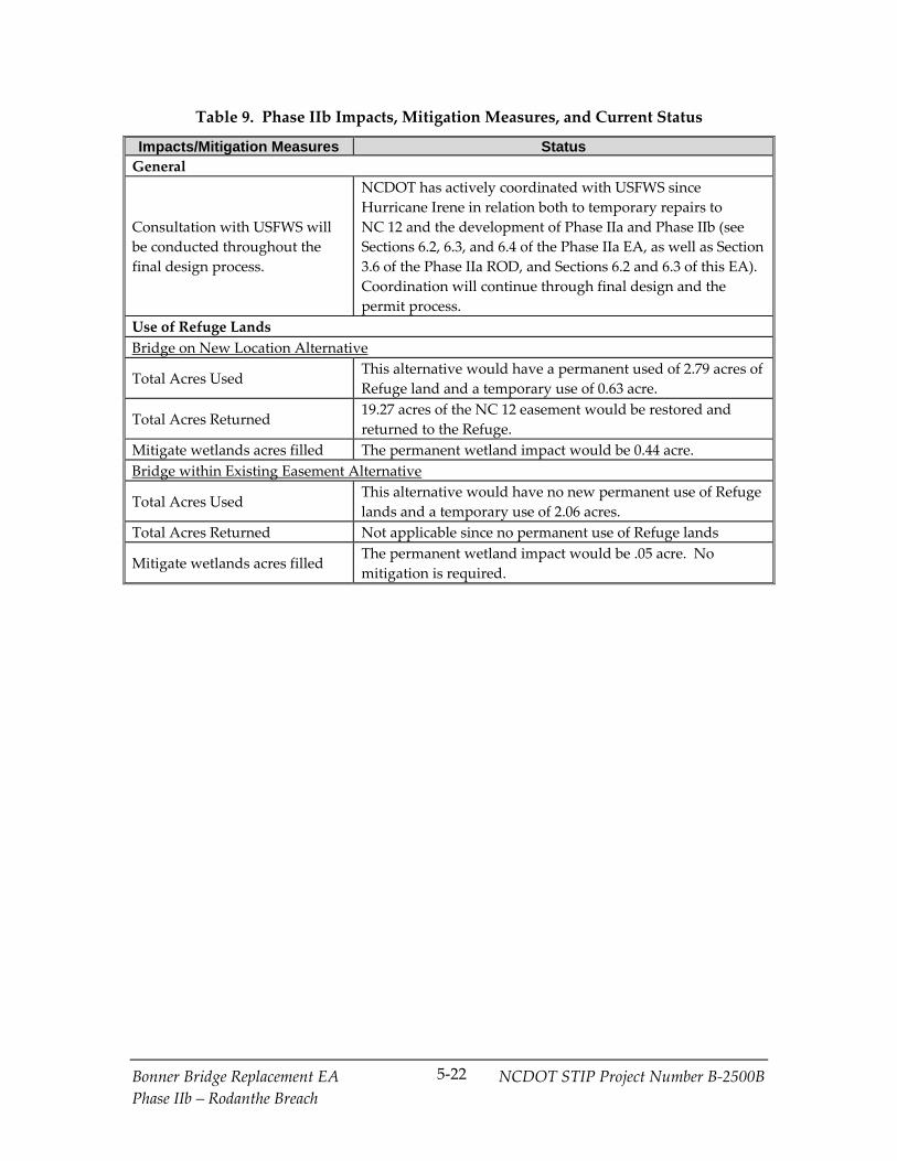
Bonner Bridge Replacement EA NCDOT STIP Project Number B‐2500B
Phase IIb – Rodanthe Breach
5‐22
Table 9. Phase IIb Impacts, Mitigation Measures, and Current Status
Impacts/Mitigation Measures Status General
Consultation with USFWS will
be conducted throughout the
final design process.
NCDOT has actively coordinated with USFWS since
Hurricane Irene in relation both to temporary repairs to
NC 12 and the development of Phase IIa and Phase IIb (see
Sections 6.2, 6.3, and 6.4 of the Phase IIa EA, as well as Section
3.6 of the Phase IIa ROD, and Sections 6.2 and 6.3 of this EA).
Coordination will continue through final design and the
permit process.
Use of Refuge Lands
Bridge on New Location Alternative
Total Acres Used This alternative would have a permanent used of 2.79 acres of
Refuge land and a temporary use of 0.63 acre.
Total Acres Returned 19.27 acres of the NC 12 easement would be restored and
returned to the Refuge.
Mitigate wetlands acres filled The permanent wetland impact would be 0.44 acre.
Bridge within Existing Easement Alternative
Total Acres Used This alternative would have no new permanent use of Refuge
lands and a temporary use of 2.06 acres.
Total Acres Returned Not applicable since no permanent use of Refuge lands
Mitigate wetlands acres filled The permanent wetland impact would be .05 acre. No
mitigation is required.
Bonner Bridge Replacement EA NCDOT STIP Project Number B‐2500B
Phase IIb – Rodanthe Breach
6‐1
6.0 Comments and Coordination
6.1 Public Meetings and Activities
6.1.1 Citizens Informational Workshops for Scoping
As a part of scoping for Phase II, three Citizens Informational Workshops were held in
December 2011 and January 2012 to provide the public with an opportunity to review
and revisit the alternatives considered in the 2008 FEIS and the 2010 EA for the locations
that were later breached by Hurricane Irene (Pea Island and Rodanthe) and to obtain
scoping feedback from the public regarding ideas, thoughts, and suggestions about
those alternatives and other alternatives that might be considered. A summary of these
workshops is presented in Section 6.1.1 of the Phase IIa EA, beginning on page 6‐1.
6.1.2 Phase IIa Public Hearings
Three Combined (Corridor and Design) Public Hearings were held on:
March 11, 2013 at the Dare County Administration Building in Manteo.
March 12, 2013 at the Rodanthe‐Waves‐Salvo Community Center in Rodanthe.
March 13, 2013 at the Ocracoke Community Center in Ocracoke.
The primary purpose of the public hearings was to receive public comment on the
findings of the Phase IIa EA. Each public hearing used an informal open‐house format
with no formal presentation. Opportunities were provided for making both oral and
written comments. The same project information was presented at all three meetings. A
total of approximately 382 people attended the hearings.
The public hearings updated the public on the status of the project since the release of
the Record of Decision (ROD) in December 2010 (2010 ROD) and presented the Preferred
Alternative for long‐term improvements in the Pea Island inlet area (Phase IIa). A
slideshow and handouts were provided. The meeting room included multiple stations
where project staff responded to questions and comments from the public. The primary
station focused on the proposed Phase IIa Preferred Alternative design (Selected
Alternative in the Phase IIa ROD). In anticipation of a high level of public interest,
informational stations on other aspects of NC 12 were also provided, including: the
status of Phase IIb (now the focus of this EA), the status of the Oregon Inlet Bridge
replacement (Phase I), other future NC 12 improvement projects south of Rodanthe, and
ferry service. Other stations included a social media table and an area to submit
comments.
The public comment period for the Phase IIa EA ended March 28, 2013. A total of 4,209
comments were received during the comment period; in addition, a petition was
Bonner Bridge Replacement EA NCDOT STIP Project Number B‐2500B
Phase IIb – Rodanthe Breach
6‐2
received containing 1,700 signatures. The comments covered a range of issues,
including the need for the project, the proposed new bridge at Pea Island inlet (Phase IIa
Preferred Alternative), the long‐term plans at Rodanthe, other needs along NC 12, and
recreational use of the area. There also were comments about whether a long bridge
(either a Pamlico Sound Bridge [Bodie Island to Rodanthe] or a bridge from the
mainland or Roanoke Island to Rodanthe) should be considered. NCDOT received 150
individual written comments, and one oral comment was recorded during the public
hearings. Most comments received were form e‐mails sent at the request of either the
Defenders of Wildlife in opposition to the project (1,597) or The Citizens Action
Committee to Replace the Herbert C. Bonner Bridge in favor of the project (2,461). The
North Carolina Conservation Network submitted a petition in opposition to the project
containing 1,700 signatures. Many of the form emails included additional comments
explaining the commenter’s position. Of the 4,209 comments received, most comments
expressed support for a long‐term solution for NC 12, although they offered differing
opinions about what the solution should be.
A full discussion of and response to comments received from members of the public, in
addition to comments received from non‐governmental organizations and from federal
and state environmental resource and regulatory agencies are presented in the Phase IIa
ROD. Public comments and responses related directly to Phase IIb are repeated in
Appendix C of this EA in Section C.3.
6.1.3 Newsletters
NCDOT issued a Bonner Bridge Update newsletter in February 2013. The newsletter
was mailed to everyone on the Bonner Bridge Replacement Project’s (B‐2500) mailing
list, which includes Hatteras Island property owners, individuals on the Refuge’s
mailing list, and individuals who attended past Citizens Informational Workshops.
The newsletter discussed the availability of the Phase IIa EA and described the Preferred
Alternative (Bridge within Existing NC 12 Easement Alternative) in the Pea Island inlet
area. The newsletter also informed the public of the public hearings that were scheduled
to be held March 11, 12, and 13, 2013, and indicated how to contact the study team,
including the toll‐free telephone number (see below). A copy of the newsletter is
included in Appendix B.
Another newsletter will be mailed prior to planned public hearings for Phase IIb.
6.1.4 Toll-Free Telephone Number
The project’s toll‐free telephone number was provided in the February 2013 newsletter.
It is answered by a senior member of NCDOT’s consultant team (led by Parsons
Brinckerhoff), and provides a means for citizens to obtain answers to questions about
the Bonner Bridge Replacement Project (B‐2500) and to make individual comments at
any time during the study. The phone number is 1‐866‐803‐0529, and it has been

Bonner Bridge Replacement EA NCDOT STIP Project Number B‐2500B
Phase IIb – Rodanthe Breach
6‐3
available throughout the 2005 SDEIS, 2007 SSDEIS, 2008 FEIS, 2010 EA, 2010 ROD, Phase
IIa EA, and Phase IIa ROD preparation portions of the study. This toll‐free telephone
number will continue to be open at least until the NEPA process associated with Phase
IIb is complete.
6.1.5 Web Sites
The newsletter provided a web site and social media resources by which those interested
could view information about the damage to NC 12 caused by Hurricane Irene,
Hurricane Sandy, and other storm events as well as NCDOT’s efforts to temporarily
restore NC 12 to service. The web sites and other social media resources are:
Bonner Bridge Replacement Project (B‐2500) Phase II Web Site – http://www.ncdot
.gov/projects/bonnerbridgephase2/
NC 12 Projects Web Site – http://www.ncdot.gov/nc12/. (Note that this web page
includes links to all NC 12‐related NCDOT projects, including the Phase II link
above and a link to information on Phase I, the new Oregon Inlet bridge.)
NC 12 Recovery Web Site – www.ncdot.org/travel/nc12recovery
NC 12 Twitter Feed – http://twitter.com/NCDOT_NC 12
Repairing NC 12 Blog – http://nc12repairs.blogspot.com/
NC 12 Facebook Page – https://www.facebook.com/NCDOT
6.2 NEPA/Section 404 Merger Team Meetings and Outcomes
The NEPA/Section 404 Merger Process is a streamlining effort that helps to avoid
duplication of effort between the NEPA and the Clean Water Act Section 404 processes,
since USACE must meet the requirements of NEPA in order to issue a dredge and fill
permit under the Clean Water Act. Stakeholders can reach concurrence or agreement; or
the Merger Process also may involve instances of non‐concurrence or abstention.6 The
goal of the Merger Process is to obtain stakeholder concurrence on key issues during the
NEPA study so that those decisions do not need to be revisited during application for a
USACE permit. The current Merger Team members are: NCDOT; FHWA; USACE;
6 The Merger Process guidelines define abstention as follows: “… abstain means that a team
member does not actively object to a concurrence point but the agency representative does not
sign the concurrence point form. The process may continue and the agency representative agrees
not to revisit the concurrence point. Written justification for abstaining from a concurrence point
should be provided to the project team within 5 days of the concurrence meeting.”
Bonner Bridge Replacement EA NCDOT STIP Project Number B‐2500B
Phase IIb – Rodanthe Breach
6‐4
USEPA; USFWS (Raleigh Office); USFWS—Pea Island National Wildlife Refuge; NMFS;
NPS—Cape Hatteras National Seashore; NCDENR‐DCM; NCDENR‐DMF; NCDENR‐
DWR; NCWRC; NCDCR; and the Albemarle Rural Planning Organization (RPO).
USCG is not a signing team member, but is sent information before and following all
NEPA/Section 404 Merger Team meetings.
The Merger Process includes the following concurrence points:
1. Concurrence on purpose and need;
2. Concurrence on the alternatives to be evaluated in detail in the environmental
document;
2A. Concurrence on the approximate length of any proposed bridges to minimize
impacts to wetlands and streams, and preliminary alignment review for each
detailed study alternative;
3. Concurrence on the Least Environmentally Damaging Practicable Alternative
(LEDPA);
4A. Concurrence that all efforts were made to avoid and minimize harm to USACE
jurisdictional resources (streams and wetlands) to the maximum extent practicable;
4B. Concurrence on the 30 percent complete hydraulic design; and
4C. Concurrence on permit drawings after the hydraulic design is complete and prior to
Section 404 permit application.
For more details on the Merger Process, see Section 8.3.1 of the 2008 FEIS.
The following Merger Team Meetings have been held to date for Phase II of the Bonner
Bridge Replacement Project (B‐2500):
August 31, 2011 Merger Team Meeting: This meeting was held to determine issues
and discuss response strategies for the emergency repair of the damage caused by
Hurricane Irene to NC 12 on Hatteras Island in order to re‐open NC 12 to traffic as
early as possible.
October 18, 2011 Merger Team Meeting: This was an informational/scoping meeting
for Phase II. The purpose of the meeting was for NCDOT to inform the Merger
Team members about the start of the Phase II studies of long‐term repairs at the two
areas along NC 12 that were breached by Hurricane Irene in August 2011 (i.e., Pea
Island inlet and Rodanthe). Agency representatives were asked to provide scoping
comments related to impact issues and alternatives related to the two breach sites
prior to NCDOT’s initiation of these studies.

Bonner Bridge Replacement EA NCDOT STIP Project Number B‐2500B
Phase IIb – Rodanthe Breach
6‐5
December 15, 2011 Merger Team Meeting: This meeting was the initial Concurrence
Point (CP) 2/2A meeting for Phase II of the Bonner Bridge Replacement Project
(B‐2500). The purposes of the meeting were to determine the alternatives to be
studied in detail (CP 2) for Phase II at the two breach areas (i.e., Pea Island inlet and
Rodanthe), as well as to discuss any additional bridging decisions associated with
the detailed study alternatives (CP 2A).
March 21, 2012 Merger Team Meeting: The purpose of this meeting was for the
Merger Team to discuss consensus on CP 2/2A, 3, and 4A for the Phase IIa project
and CP 2/2A for the Phase IIb project. Concurrence was not reached at this meeting.
Further studies were undertaken to address concerns raised by USACE and other
merger team members. The USACE indicated that NCDOT needed to complete a re‐
evaluation of the cost of the Pamlico Sound Bridge Corridor to determine if the
conclusion reached in the 2010 EA – that this alternative was not practicable from the
perspective of Section 404 of the Clean Water Act or feasible and prudent from the
perspective of Section 4(f) of the Department of Transportation Act of 1966 –
remained valid. Also discussed with the Merger Team was the agreement at the
December 15 Merger Team meeting to look at the merits of a Seven‐Mile Bridge, as
suggested by USFWS, that would address both parts of the Phase II study area.
May 16, 2012 Merger Team Meeting: The purpose of the meeting was informational.
NCDOT discussed with the Merger Team agencies, and received feedback
regarding, a design for NCDOT’s proposed Preferred Alternative for Phase IIa. The
design issues discussed would likely affect the permit applications for the proposed
project and would apply to the Phase IIb detailed study alternatives. These issues
include the use of temporary construction easements, utility placement, and use of
retaining walls, jetting, and other design‐related issues.
November 14, 2012 Merger Team Meeting: This meeting occurred after the
completion of additional studies requested at the May 21, 2012 meeting. The
updated cost analysis requested was completed in October 2012. The analysis
reaffirmed that NCDOT is unable to fully fund a Pamlico Sound bridge. The USACE
indicated their agreement with this conclusion at a meeting between NCDOT,
FHWA, and USACE on October 29, 2012. At the November Merger Team meeting,
FHWA, NCDOT, USACE, NCDENR‐DWQ (now NCDENR‐DWR), NCDCR, and
NCDENR‐DCM signed the Phase IIa concurrence forms for CP2, CP2A, and CP3, as
well as the Phase IIb concurrence form for CP2A. USEPA, USFWS, USFWS‐Refuge,
NMFS, NPS, NCDENR‐DMF, and NCWRC abstained. Issues related to CP4A were
also discussed. Concurrence was reached at this meeting that the Bridge within
Existing NC 12 Easement Alternative would be the sole detailed study alternative for
Phase IIa, and that two detailed study alternatives would be analyzed for Phase IIb:
the Bridge on New Location Alternative and the Bridge within Existing NC 12
Easement Alternative. Prior to this merger meeting, NCDOT met with FHWA and

Bonner Bridge Replacement EA NCDOT STIP Project Number B‐2500B
Phase IIb – Rodanthe Breach
6‐6
USACE on October 29, 2012 to discuss the re‐evaluation of alternatives for Phase II,
including the financial feasibility of the Pamlico Sound Bridge Corridor.
January 30, 2013 Merger Team Meeting: This meeting was held in order to finalize
concurrence on CP4A and to discuss CP4B and CP4C for Phase IIa. All members of
the Merger Team signed the CP4A concurrence form except for USEPA, which
abstained.
July 25, 2013 Merger Team Meeting: This meeting focused on potential mitigation
for impacts in the Refuge with the Bridge on New Location Alternative. The
USFWS‐Refuge had indicated that the Bridge on New Location Alternative likely
could be considered a minor modification of the existing NC 12 easement. It was
stated that NCDOT and USFWS have agreed that the section of existing NC 12
easement that is bypassed by the Bridge on New Location Alternative would be
restored and returned to the Refuge as mitigation. NCDOT noted that in previous
mitigation discussions with the Refuge, an idea also had been proposed by the
Refuge to “nourish” the estuarine (soundside) shoreline in order to build up and
support the natural migration of Hatteras Island. The following concerns were
raised by Merger Team members regarding this idea: it would impact SAV habitat,
it would be costly and risky in terms of unknown benefits and impacts, and it was
not needed from a USACE jurisdictional impacts perspective. The Merger Team
agreed that a soundside nourishment program could be considered as an option for
disposal of jetting spoils, but only after further coordination with the appropriate
agencies. The Refuge representative urged NCDOT to “think outside the box” on
means that might be used in the context of the Phase IIb project to facilitate accretion
on the sound side of Hatteras Island.
The summaries and concurrence forms for the meetings through November 14, 2012
were presented in the Phase IIa EA in Appendix A. The full meeting summary of the
July 25, 2013 meeting is included in Appendix A of this Phase IIb EA. Summaries of
additional meetings held with various agencies are included in Section 6.2 of the Phase
IIa EA, beginning on page 6‐3. The minutes and concurrence forms for the meeting on
January 20, 2013 were presented in Appendix D of the Phase IIa ROD. Summaries of
additional meetings held with various agencies are included in Section 3.6 of the Phase
IIa ROD beginning on page 25.
6.3 Endangered Species Act Consultation
As a part of finalizing the Phase II alternatives for implementation, including the Phase
IIb project that is the subject of this EA, FHWA has consulted with USFWS and NMFS in
compliance with Section 7 of the ESA of 1973.
During the planning and permitting processes for Phase I and IIa, NCDOT coordinated
with the USFWS and SHPO regarding specific design and construction issues, in
Bonner Bridge Replacement EA NCDOT STIP Project Number B‐2500B
Phase IIb – Rodanthe Breach
6‐7
keeping with the existing Section 7 and Section 106 agreements. To minimize impacts to
nesting sea turtles, NCDOT has committed to using approved lighting sources during
construction of bridges within the Refuge, which include either amber‐colored LED
lights (preferred) or low‐pressure sodium‐vapor lights. Additionally, NCDOT, FHWA,
USFWS, and SHPO agreed to a bridge rail design that is intended to shield sea turtle
hatchlings from car headlights on bridges. The bridge rail design is illustrated in Figure
3 of the Phase IIa EA. The lighting commitment would apply to either of the two
detailed study alternatives, while the bridge rail commitment most likely would apply
only to the Bridge within Existing NC 12 Easement alternative. The railing design
would have to be reviewed by USFWS and SHPO in compliance with the commitments.
FHWA also has completed formal consultation with NMFS on potential impacts to
sturgeon and sea turtles. Formal consultation concluded with the receipt of a letter from
NMFS on September 30, 2013 (see Appendix D of the Phase IIa ROD).
6.4 Essential Fish Habitat Coordination
As a part of finalizing the Phase II alternatives for implementation, including Phase IIb,
FHWA will coordinate with NMFS regarding EFH. The Magnuson‐Stevens Fishery
Conservation and Management Act (16 U.S.C. § 1801 et seq.) requires federal agencies to
consult with the US Secretary of Commerce on all actions or proposed actions
authorized, funded, or undertaken by the agency that might adversely affect EFH. This
is done through NMFS. NMFS is represented on the NEPA/Section 404 Merger Team.
As part of this coordination with NMFS for Phase IIb, NCDOT has developed an EFH
Assessment Addendum. This report focuses on the potential for EFH impacts
associated with the new Bridge on New Location Alternative, which was not evaluated
in the 2008 EFH Assessment, but is similar to the Bridge South component of the Road
North/Bridge South alternative evaluated in the 2008 FEIS. The Bridge within Existing
NC 12 Easement Alternative, which was considered as a part of the Phased Approach
Alternative in the 2008 EFH Assessment, also is addressed. In the Phase IIb project area
(the southern end of the Refuge and the Rodanthe area), there has been no substantial
change in EFH habitat since the 2008 FEIS. While Hurricane Irene created a breach in
the Rodanthe area in August 2011, the breach was filled by NCDOT and no new EFH
was established in this area.
6.5 Section 106 of the National Historic Preservation Act Coordination
Section 106 of the National Historic Preservation Act of 1966 as amended (16 U.S.C.
§ 470f) affords consideration of those properties that are listed or eligible for listing in
the NRHP. The Phase IIb detailed study alternatives are similar in characteristics to
alternatives previously described in the 2008 FEIS and in the 2010 EA; the Bridge within
Existing NC 12 Easement Alternative is similar to the Phased Approach/Rodanthe
Bridge Alternative, and the Bridge on New Location Alternative is similar to the Bridge

Bonner Bridge Replacement EA NCDOT STIP Project Number B‐2500B
Phase IIb – Rodanthe Breach
6‐8
South component of the Road North/Bridge South Alternative. Both of the Phase IIb
detailed study alternatives would have an Adverse Effect on the NRHP‐eligible Pea
Island National Wildlife Refuge. The nature of the Adverse Effect is the visual impact
on the historic landscape of the Refuge. This impact is described in Section 4.2.3 of this
EA.
As discussed in Project Commitment 23 in the Project Commitments in Appendix E of
the Phase IIa ROD, FHWA, SHPO, ACHP, and NCDOT, along with the consulting
parties (Dare County, the North Carolina Aquarium Society, USFWS, NPS, and the
Chicamacomico Historical Association), developed a Programmatic Agreement (PA)
stipulating measures that FHWA will ensure are carried out during the design and
construction of the PBC/TMP Alternative to mitigate adverse impacts to the historic
cultural resources. NCDOT, FHWA, and SHPO signed the Programmatic Agreement
(PA) on historic resource impacts and mitigation in November 2010 (see Appendix D of
the 2010 ROD). It was amended in 2013 to include a final agreement on the
characteristics of bridge rails in the Refuge for Phases I and IIa (see the paragraph at the
end of this section). NCDOT is in the process of fulfilling the commitments made in the
PA, as amended, in parallel with preparations to start construction of Phase I of the
Bonner Bridge Replacement Project (B‐2500). The PA is applicable to the entire Project,
and Stipulation #VI of the PA requires further consultation for future phases if there is:
A change in the historic status of properties.
Identification of a new alternative.
Change in an existing alternative that would result in a different “effects
determination” for a historic property.
Selection of a new Preferred Alternative.
None of these conditions apply to Phase IIb or to its current setting. A representative of
SHPO (from NCDCR) who serves on the NEPA/Section 404 Merger Team, concurred
with the detailed study alternatives for Phase IIb and has had an opportunity to indicate
if any of the above conditions were met or indicate that additional consultation was
desired.
Stipulation #IIA of the PA discusses bridge design within the Refuge, in particular the
design of the bridge rail. In accordance with this stipulation, further coordination about
the bridge rail occurred in 2013 between NCDOT, USFWS, NPS, and SHPO. The
agencies agreed on a parapet design of 30 inches high for Phase I and up to 36 inches
high for the bridge railing through the Refuge with Phase IIa, which shields sea turtle
hatchlings from headlight glare. This agreement resulted in the amendment to the PA
presented in Appendix E of the Phase IIa ROD.

Bonner Bridge Replacement EA NCDOT STIP Project Number B‐2500B
Phase IIb – Rodanthe Breach
6‐9
6.6 List of Agencies, Organizations, and Persons to Whom Copies of the Environmental Assessment are Sent
The agencies and interest groups listed below will be sent a copy of this EA with a
request for comments. These agencies and interest groups also were sent a copy of the
2008 FEIS, 2010 EA, 2010 ROD, Phase IIa EA, and Phase IIa ROD. The availability of the
EA will be announced via a newsletter sent to those on the project’s mailing list and in
advertisements within local media outlets. The EA also will be available on the project
web site (http://www.ncdot .gov/projects/bonnerbridgephase2/). Public hearings will be
held to gather additional comments on the EA. Comments on the EA will be addressed
in subsequent documentation.
Federal Agencies
Advisory Council on Historic
Preservation
Federal Emergency Management
Agency
US Army Corps of Engineers
US Coast Guard—5th District
US Department of Agriculture—Natural
Resources Conservation Service
US Department of Commerce—National
Oceanic and Atmospheric
Administration—National Marine
Fisheries Service
US Department of Health and Human
Services
US Department of Housing and Urban
Development
US Department of the Interior—Office
of the Secretary; US Fish and Wildlife
Service (Pea Island National Wildlife
Refuge and Raleigh Field Office);
Keeper of the National Register; and
National Park Service (Cape Hatteras
National Seashore)
US Environmental Protection Agency,
Region IV (Environmental Review
Branch)
State Agencies
North Carolina Department of
Administration—State Clearinghouse
and State Publications Clearing House
(State Library)
North Carolina Department of Cultural
Resources—Division of Archives and
History
North Carolina Department of
Environment and Natural Resources—
Division of Air Quality; Division of
Coastal Management; Division of Land
Resources; Division of Marine Fisheries;
Division of Parks and Recreation;
Division of Water Resources
Bonner Bridge Replacement EA NCDOT STIP Project Number B‐2500B
Phase IIb – Rodanthe Breach
6‐10
North Carolina Wildlife Resources
Commission
Local Governments and Agencies
Albemarle Regional Planning and
Development Commission (Albemarle
Rural Planning Organization)
County of Dare—Chair, Dare County
Commissioners; Dare County Manager;
Emergency Management Agency
Mayor of Duck
Mayor of Kill Devil Hills
Mayor of Kitty Hawk
Mayor of Manteo
Mayor of Nags Head
Mayor of Southern Shores
Oregon Inlet and Waterways
Commission
Local Interest Groups
Audubon North Carolina
Carolina Electric Cooperatives
Center for Biological Diversity
Coastal Wildlife Refuge Society
Conservation Council of North Carolina
Dare County Tourist Bureau
Defenders of Wildlife
Eastern Surfing Association, Outer
Banks District
Environmental Defense Fund
Hatteras Village Civic Association
National Parks Conservation
Association
North Carolina Coastal Federation
North Carolina Fisheries Association
Outer Banks Chamber of Commerce
Pamlico – Tar River Foundation
Sierra Club, North Carolina Chapter
Southern Albemarle Association
Southern Appalachian Biodiversity
Project
Southern Environmental Law Center
Surfrider Foundation, Outer Banks
Chapter

Bonner Bridge Replacement EA NCDOT STIP Project Number B‐2500B
Phase IIb – Rodanthe Breach
6‐1ƕ
Public Review Locations
Dare County Libraries in Hatteras
Village, Kill Devil Hills, and Manteo,
North Carolina
Dare County Planning and Inspections
Satellite Office in Frisco, North Carolina
Fessenden Recreation Center in Buxton,
North Carolina
NCDOT Resident Engineer’s Office in
Manteo, North Carolina
Ocracoke School and Community
Library in Ocracoke, North Carolina


Bonner Bridge Replacement EA NCDOT STIP Project Number B‐2500B
Phase IIb – Rodanthe Breach
7‐1
7.0 Conclusion This Environmental Assessment (EA) documents changes associated with the Bonner
Bridge Replacement Project (B‐2500), as well as changes to the project environment, as
they relate to the planned Phase IIb.
From the analysis contained in Chapter 4.0, FHWA believes that the Phase IIb
detailed study alternatives, including the Preferred Alternative, do not result in new,
significant impacts to the human and natural environments not previously identified
in the 2008 FEIS and 2010 EA. This is the case because these alternatives represent
portions of the Road North/Bridge South, All‐Bridge, and Phased Approach
alternatives assessed in their entirety in the 2008 FEIS and 2010 EA.
From the analysis contained in Chapter 5.0, FHWA believes that the conclusions in
the 2009 Revised Final Section 4(f) Evaluation (included as Appendix B in the 2010
EA) remain valid for the PBC/TMP Alternative and the analysis in Chapter 5.0 does
not suggest any new, significant impacts not previously identified in the 2008 FEIS,
2010 EA, and Phase IIa EA. It also concludes that both Phase IIb detailed study
alternatives would offer the lesser harm on some impact considerations and greater
harm on other impact considerations. Further, FHWA and NCDOT have concluded
that as with the consideration of the least harm to the Refuge as a historic resource in
Factor #4, the views of the official(s) with jurisdiction over the management of the
Refuge, USFWS under Section 7 of the Endangered Species Act, and the NMFS and
FMCs under Magnuson‐Stevens Fishery Conservation and Management Act, as well
as the residents, business owners, property owners of the section of Rodanthe
affected, and other members of the public are important to finalizing a decision of
least harm. The views of these stakeholders, as well as the SHPO, are being solicited
by the distribution of this Phase IIb EA and will be taken into consideration in
reaching a conclusion on least harm that will be documented in a Phase IIb ROD or
supplemental EIS.
Based on this analysis and in coordination with state and federal environmental
resource and regulatory agencies, FHWA believes that the changes identified and
assessed in this EA for the two Phase IIb detailed study alternatives, including the
Preferred Alternative (Bridge within Existing NC 12 Easement Alternative), would not
result in new, significant impacts not previously identified in the 2008 FEIS, 2010 EA,
2010 ROD, or Phase IIa EA.
FHWA now seeks input on the content and tentative conclusions identified in this EA.
Once public and agency input have been received and considered, FHWA will
determine whether a Supplemental EIS will be prepared.


Bonner Bridge Replacement EA NCDOT STIP Project Number B‐2500B
Phase IIb – Rodanthe Breach
8‐1
8.0 List of References CZR, Incorporated. 2008. Essential Fish Habitat Assessment for NC 12 Replacement of
Herbert C. Bonner Bridge. Prepared for the North Carolina Department of
Transportation.
CZR, Incorporated. 2008. Natural Resources Technical Report for NC 12 Replacement of
Herbert C. Bonner Bridge. Prepared for the North Carolina Department of
Transportation.
CZR, Incorporated. 2013. Essential Fish Habitat Assessment Addendum for Phase IIa of NC
12 Replacement of Herbert C. Bonner Bridge. Prepared for the North Carolina
Department of Transportation.
CZR, Incorporated. 2013. Essential Fish Habitat Assessment Addendum for Phase IIb of NC
12 Replacement of Herbert C. Bonner Bridge. Prepared for the North Carolina
Department of Transportation.
Federal Highway Administration and North Carolina Department of Transportation.
2005. Administrative Action Supplemental Draft Environmental Impact Statement and
Draft Section 4(f) Evaluation for NC 12 Replacement of Herbert C. Bonner Bridge.
Federal Highway Administration and North Carolina Department of Transportation.
2007. Administrative Action Supplement to the 2005 Supplemental Draft
Environmental Impact Statement and Draft Section 4(f) Evaluation for NC 12
Replacement of Herbert C. Bonner Bridge.
Federal Highway Administration and North Carolina Department of Transportation.
2008. Administrative Action Final Environmental Impact Statement and Section 4(f)
Evaluation for NC 12 Replacement of Herbert C. Bonner Bridge.
Federal Highway Administration and North Carolina Department of Transportation.
2008. Biological Assessment for NC 12 Replacement of Herbert C. Bonner Bridge.
Federal Highway Administration and North Carolina Department of Transportation.
2010. Administrative Action Environmental Assessment for NC 12 Replacement of
Herbert C. Bonner Bridge.
Federal Highway Administration and North Carolina Department of Transportation.
2010. Administrative Action Record of Decision for NC 12 Replacement of Herbert C.
Bonner Bridge.
Bonner Bridge Replacement EA NCDOT STIP Project Number B‐2500B
Phase IIb – Rodanthe Breach
8‐2
Federal Highway Administration and North Carolina Department of Transportation.
June 2012. NC 12 Transportation Management Plan – Phase II, Peer Exchange
Meeting for NC 12 Replacement of Herbert C. Bonner Bridge.
Federal Highway Administration and North Carolina Department of Transportation.
2012. Technical Memorandum on the Effects of Parallel Bridge Corridor with NC 12
Transportation Management Plan Alternative for NC 12 Replacement of Herbert C.
Bonner Bridge on Atlantic Sturgeon.
Federal Highway Administration and North Carolina Department of Transportation.
May 2013. Threatened and Endangered Species Technical Memorandum for Pea Island
Long‐Term Improvements Bonner Bridge Replacement Project Phase IIa.
Federal Highway Administration and North Carolina Department of Transportation.
2013. Threatened and Endangered Species Technical Memorandum for Pea Island Long‐
Term Improvements Bonner Bridge Replacement Project Phase IIb.
Jackson, J., K. Coder, R. Gilbert, T. Patrick, C. Rabolli, and L. Tankersley. 1992. Georgia’s
Endangered Animals and Plants. Cooperative Extension Service/University of
Georgia, College of Agricultural and Environmental Sciences, Athens, GA.
North Carolina Department of Transportation. 2013. Air Quality Analysis, NC 12 Long‐
Term Improvements in Rodanthe, Dare County.
North Carolina Department of Transportation. 2013. Traffic Noise Analysis, NC 12 Long‐
Term Improvements in Rodanthe, Dare County.
Overton, M. F. January 2013. Coastal Monitoring Program, NC 12 Transportation
Management Plan, TIP Project B‐2500, 2011 Update. Prepared for the North
Carolina Department of Transportation.
Overton and Fisher. June 2005. Parallel Bridge Corridor with NC 12 Maintenance –
Shoreline Change and Stabilization Analysis. Prepared for the North Carolina
Department of Transportation.


![Nicholas Sparks - Nopti in Rodanthe [Ibuc.info]](https://img.dokumen.tips/doc/110x75/563dbf86550346aa9ab0c0cd/nicholas-sparks-nopti-in-rodanthe-ibucinfo.jpg)
![Sparks Nicholas - Éjjel a parton (Nights in Rodanthe) [2008]](https://img.dokumen.tips/doc/110x75/577cd4ea1a28ab9e789975f8/sparks-nicholas-ejjel-a-parton-nights-in-rodanthe-2008.jpg)