Embed Size (px)
Citation preview
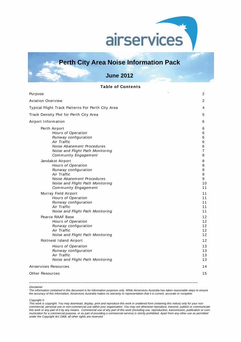
Table of Contents
Purpose ` 2
Aviation Overview 2
Typical Flight Track Patterns For Perth City Area 4
Track Density Plot for Perth City Area 5
Airport Information 6
Perth Airport 6 Hours of Operation 6 Runway configuration 6 Air Traffic 6 Noise Abatement Procedures 6 Noise and Flight Path Monitoring 7 Community Engagement 8
Jandakot Airport 8 Hours of Operation 8 Runway configuration 9 Air Traffic 9 Noise Abatement Procedures 9 Noise and Flight Path Monitoring 10 Community Engagement 11
Murray Field Airport 11 Hours of Operation 11 Runway configuration 11 Air Traffic 11 Noise and Flight Path Monitoring 11
Pearce RAAF Base 12 Hours of Operation 12 Runway configuration 12 Air Traffic 12 Noise and Flight Path Monitoring 12
Rottnest Island Airport 12
Hours of Operation 13 Runway configuration 13 Air Traffic 13 Noise and Flight Path Monitoring 13
Airservices Resources 14
Other Resources 15
_________________________________________________________________ Disclaimer The information contained in this document is for information purposes only. While Airservices Australia has taken reasonable steps to ensure the accuracy of this information, Airservices Australia makes no warranty or representation that it is current, accurate or complete. Copyright © This work is copyright. You may download, display, print and reproduce this work in unaltered form (retaining this notice) only for your non-commercial, personal use or non-commercial use within your organisation. You may not otherwise reproduce, transmit, publish or communicate this work or any part of it by any means. Commercial use of any part of this work (including use, reproduction, transmission, publication or com-munication for a commercial purpose, or as part of providing a commercial service) is strictly prohibited. Apart from any other use as permitted under the Copyright Act 1968, all other rights are reserved.
Perth City Area Noise Information Pack
June 2012
2
Purpose The purpose of this document is to provide information on aircraft operations throughout the Perth area to the community.
The Perth area is affected by aircraft noise from five airfields: Perth Airport, Jandakot Airport, Pearce RAAF Base, Murray Field Airport and Rottnest Island Airport. The location of these airfields is shown in Figure 1. In addition to aircraft operations to and from these airfields, other contributors to aircraft noise include helicopter operations which occur at hospitals or river front helipads.
Aviation Overview This section provides a summary of the key aspects of aviation that affect aircraft noise and operations in the Perth area.
Noise and Flight Path Monitoring
Airservices operates a Noise and Flight Path Monitoring System (NFPMS) based at Perth Airport. Flight tracks from any suitably equipped aircraft operating within 50km of Perth Airport are captured by the NFPMS. This includes all commercial and scheduled air traffic but may exclude some small fixed wing aircraft (if they are not equipped with a transponder or are outside radar coverage). As well as Perth Airport this includes operations at Jandakot Airport, RAAF Base Pearce and Rottnest Island. Noise monitors can be deployed throughout the coverage of the NFPMS to capture noise data of aircraft operations. There is an internet based component of this system, WebTrak, where details about individual flights can be obtained and an aircraft noise complaint can be lodged. Links to WebTrak are provided in the “Other Resources” section.
Figure 1: Location of airfields in the Perth city area

3
Runway Naming Convention
Runway names consist of the first two digits of the compass bearing for the runway direction. For instance if the runway bearing is 210o its name will be 21. At airports where there are parallel runways an additional character is added; L, C or R to distinguish between the left, centre or right runway.
Runway Selection
Runway selection is based on weather conditions, traffic volume and noise abatement procedures. As the wind changes the active runway may change as aircraft primarily take-off and land into the wind for safety and performance reasons. This often results in different areas around the airport being overflown by aircraft at different times of the day. This includes helicopter operations where pilots generally make their approach to or depart from the helipad into the prevailing wind.
At a busy airport the decision on which runway to use also takes into consideration the traffic numbers which may override weather considerations.
At some locations the proximity of other aerodromes and the weather conditions at those locations are also factors that affect runway selection. To maximise safety the aerodromes may need to operate in the same direction. An example is the proximity of Perth Airport and the RAAF Base at Pearce.
Navigation Aids and Standard Procedures Navigation aids are used to provide safe operations into and out of airports. As an example, during periods of limited visibility such as fog, a precision navigation aid is used by pilots to guide the aircraft to a point close to the runway. Other examples are radio beacons which, when overflown, inform the aircraft it is on track to the airport. The availability of different navigation aids varies between aerodromes and varies between runways at each aerodrome.
Standard flight paths are designed to around these navigation aids. At some aerodromes more advanced procedures that make use of GPS technology are used. These consist of a series of GPS coordinates (known as “waypoints”) that suitably equipped aircraft can overfly.
The standard flight paths are published and pilots are required to use them. Where Air Traffic Control services are available the standard flight paths can be modified to deal with high traffic scenarios, much the same way as traffic police override traffic lights.
Noise Abatement Procedures and Fly Neighbourly Agreements
Noise Abatement Procedures (NAP) are designed to help reduce the impact of aircraft noise on the community. They are made up of preferred runways, preferred flight paths and noise abatement areas. The latter have restrictions on what aircraft can operate within these areas. NAPs are implemented by Air Traffic Control (ATC) but all aircraft are expected to observe the NAPs outside of ATC hours or operation. The use of NAPs at any time are subject to the weather conditions and aircraft requirements. Their use is not mandatory.
At some airports Fly Neighbourly Agreements (FNA) exist between airport management and aircraft operators to help minimise the impact of aircraft noise on the surrounding community. These can apply to all operators at the airport or to specific operators. An airport can have both NAP and FNA.
4
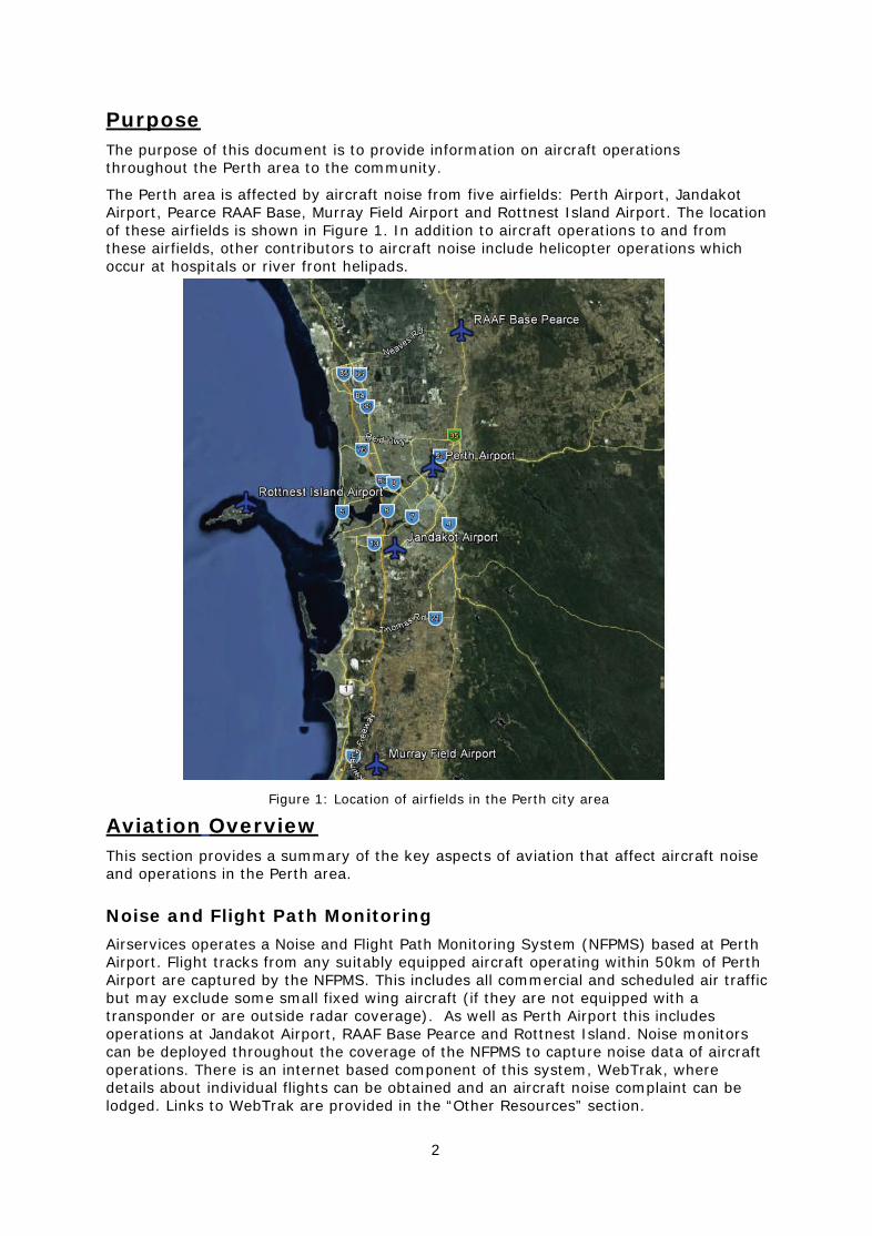
Typical Flight Track Patterns For Perth City Area The arrivals, departures and training operations at the four airfields which are covered by the Noise and Flight Path Monitoring System (NFPMS) within the Perth area (Perth, Jandakot, Pearce RAAF Base and Rottnest Island) over the period 1-3 June 2011 are shown in Figure 2 below. All commonly used arriving and departing tracks are depicted. Each line represents a track flown by one aircraft. Green tracks show departing aircraft and red tracks show arrivals. Blue tracks show small aircraft flying without flight plans (typically small fixed wing aircraft) and purple indicates a training operation (circuit training). This figure illustrates that aircraft fly over many Perth suburbs and surrounding areas and no area is immune from aircraft noise.
Figure 2: Flight tracks for three days over the Perth area, 1-3 June 2011
5
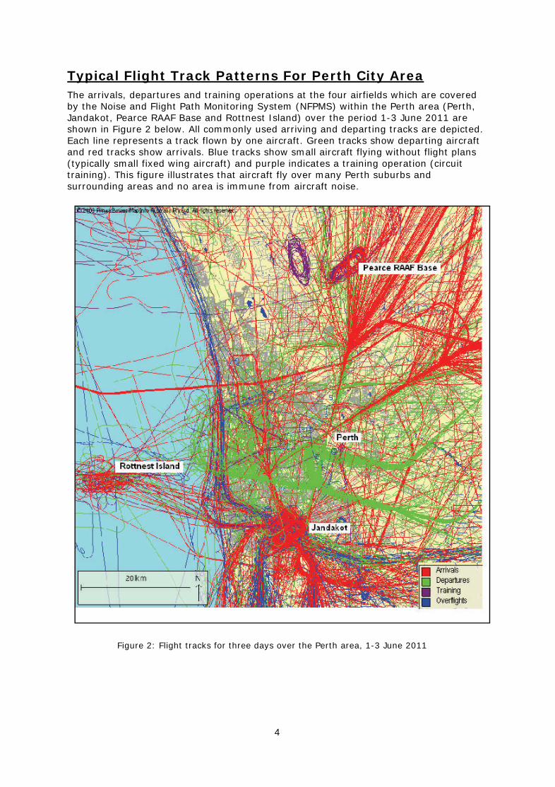
Track Density Plot for Perth City Area Track density plots display the pattern of regularly used flight tracks passing over a region during a specific period. Whilst these track plots show the most frequently used flight corridors in the region, aircraft fly over all areas of Perth, as shown in Figure 2.
Figure 3 below shows the three month track density plot for all aircraft operations for the period April-June 2011. The gray circles show the location of each Noise Monitoring Unit against their designated identifier for each terminal. (Note the Beechboro and Lathlain monitors were not in place during this period.)
The colour categories for the track density plot, varying from green to red, represent the average number of aircraft movements per day. These movements range from two overflights per day to 20 overflights per day, averaged over the three-month period. The absence of a coloured track over any given area does not necessarily mean that aircraft have not flown over that area. Where an area is not coloured there has been, on average, less than two flights per day during the period shown.
Traffic patterns vary significantly on a daily basis, such that some areas may receive days of zero movements and other days where there may be in excess of 100 over-flights. The total number of movements for the period has been averaged to show the most consistently used flight paths or corridors.
Figure 3: Track density for April-June 2011. Note Jandakot arrival paths and
departure paths are shown as red and black arrows respectively. Noise Monitoring Unit locations are: 1-Cannington, 2-Queens Park, 4-Greenmount and 5-Guildford.
6
Airport Information
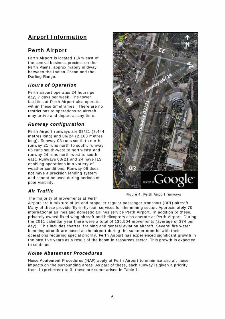
Perth Airport Perth Airport is located 11km east of the central business precinct on the Perth Plains, approximately midway between the Indian Ocean and the Darling Range.
Hours of Operation
Perth airport operates 24 hours per day, 7 days per week. The tower facilities at Perth Airport also operate within these timeframes. There are no restrictions to operations so aircraft may arrive and depart at any time.
Runway configuration
Perth Airport runways are 03/21 (3,444 metres long) and 06/24 (2,163 metres long). Runway 03 runs south to north, runway 21 runs north to south, runway 06 runs south-west to north-east and runway 24 runs north-west to south-east. Runways 03/21 and 24 have ILS enabling operations in a variety of weather conditions. Runway 06 does not have a precision landing system and cannot be used during periods of poor visibility.
Air Traffic
The majority of movements at Perth Airport are a mixture of jet and propeller regular passenger transport (RPT) aircraft. Many of these provide ‘fly-in fly-out’ services for the mining sector. Approximately 70 international airlines and domestic airlines service Perth Airport. In addition to these, privately owned fixed wing aircraft and helicopters also operate at Perth Airport. During the 2011 calendar year there were a total of 136,504 movements (average of 374 per day). This includes charter, training and general aviation aircraft. Several fire water bombing aircraft are based at the airport during the summer months with their operations requiring special priority. Perth Airport has experienced significant growth in the past five years as a result of the boom in resources sector. This growth is expected to continue.
Noise Abatement Procedures
Noise Abatement Procedures (NAP) apply at Perth Airport to minimise aircraft noise impacts on the surrounding areas. As part of these, each runway is given a priority from 1 (preferred) to 3, these are summarised in Table 1.
Figure 4: Perth Airport runways
7
Noise and Flight Path Monitoring
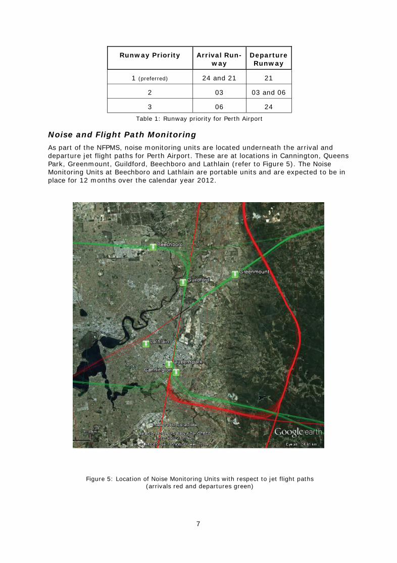
As part of the NFPMS, noise monitoring units are located underneath the arrival and departure jet flight paths for Perth Airport. These are at locations in Cannington, Queens Park, Greenmount, Guildford, Beechboro and Lathlain (refer to Figure 5). The Noise Monitoring Units at Beechboro and Lathlain are portable units and are expected to be in place for 12 months over the calendar year 2012.
Figure 5: Location of Noise Monitoring Units with respect to jet flight paths (arrivals red and departures green)
Runway Priority Arrival Run-way
Departure Runway
1 (preferred) 24 and 21 21
2 03 03 and 06
3 06 24
Table 1: Runway priority for Perth Airport
8
Community Engagement
Perth Airport provides and manages two main forums for community and stakeholder engagement:
1. Perth Airport Community Aviation Consultation Group (CACG)
2. Aircraft Noise Management Consultative Committee (ANMCC)
Community Aviation Consultation Group (CACG)
The CACG is the primary forum for community engagement with airport management and other industry stakeholders and was established in accordance with the Federal Government’s Aviation White Paper 2009.
The purpose of the CACG is to ensure community views are heard by the airport and to provide members of the community with an opportunity to obtain information about airport operations.
The CACG provides a forum to discuss a range of airport matters including aviation and non-aviation developments and planning or regulatory changes.
The Perth Airport CACG is run by an independent chair. Membership is determined by the CACG.
Aircraft Noise Management Consultative Committee (ANMCC)
The Aircraft Noise Management Consultative Committee includes representatives from Perth Airport management, Commonwealth, State and Local Government, airlines and community groups.
The ANMCC reports to the Perth Airport CACG and focuses solely on aircraft noise issues, which does include aspects of on-airport developments.
Further information on these community and stakeholder engagement forums is available on the airport’s website.
See: http://www.perthairport.com.au/AboutUs/NoiseManagement.aspx
Jandakot Airport Located 14km south of the central business precinct, Jandakot Airport is a major flight training airport. A large proportion of its operations involve circuit training. Essential service organisations such as the Royal Flying Doctor Service, Police Air Support Unit and the Conservation and Land Management Bushfire Water Bombers also operate out of Jandakot Airport.
Hours of operation
Jandakot Airport is open 24 hours per day, 7 days per week. For noise abatement, circuit training has specific hours of operations, as outlined in Table 2. Air Traffic Control hours are:
June to August Monday to Friday 7:00am-8:00pm Saturday & Sunday 8:00am-6:00pm September to May Monday to Friday 7:00am-9:00pm Saturday & Sunday 8:00am-6:00pm
9
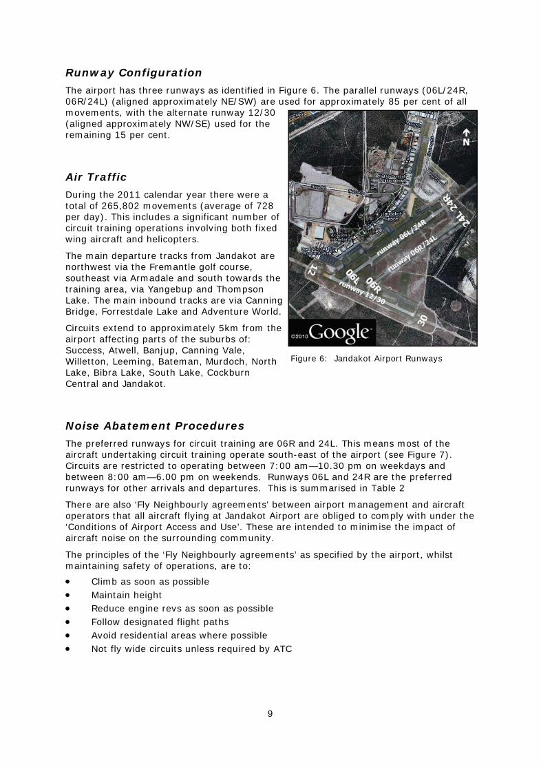
Runway Configuration
The airport has three runways as identified in Figure 6. The parallel runways (06L/24R, 06R/24L) (aligned approximately NE/SW) are used for approximately 85 per cent of all movements, with the alternate runway 12/30 (aligned approximately NW/SE) used for the remaining 15 per cent.
Air Traffic
During the 2011 calendar year there were a total of 265,802 movements (average of 728 per day). This includes a significant number of circuit training operations involving both fixed wing aircraft and helicopters.
The main departure tracks from Jandakot are northwest via the Fremantle golf course, southeast via Armadale and south towards the training area, via Yangebup and Thompson Lake. The main inbound tracks are via Canning Bridge, Forrestdale Lake and Adventure World.
Circuits extend to approximately 5km from the airport affecting parts of the suburbs of: Success, Atwell, Banjup, Canning Vale, Willetton, Leeming, Bateman, Murdoch, North Lake, Bibra Lake, South Lake, Cockburn Central and Jandakot.
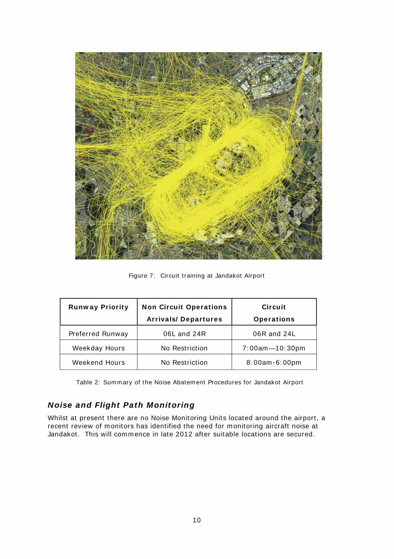
Noise Abatement Procedures
The preferred runways for circuit training are 06R and 24L. This means most of the aircraft undertaking circuit training operate south-east of the airport (see Figure 7). Circuits are restricted to operating between 7:00 am—10.30 pm on weekdays and between 8:00 am—6.00 pm on weekends. Runways 06L and 24R are the preferred runways for other arrivals and departures. This is summarised in Table 2
There are also ‘Fly Neighbourly agreements’ between airport management and aircraft operators that all aircraft flying at Jandakot Airport are obliged to comply with under the ‘Conditions of Airport Access and Use’. These are intended to minimise the impact of aircraft noise on the surrounding community.
The principles of the ‘Fly Neighbourly agreements’ as specified by the airport, whilst maintaining safety of operations, are to:
Climb as soon as possible Maintain height Reduce engine revs as soon as possible Follow designated flight paths Avoid residential areas where possible Not fly wide circuits unless required by ATC
Figure 6: Jandakot Airport Runways
10
Noise and Flight Path Monitoring
Whilst at present there are no Noise Monitoring Units located around the airport, a recent review of monitors has identified the need for monitoring aircraft noise at Jandakot. This will commence in late 2012 after suitable locations are secured.
Figure 7: Circuit training at Jandakot Airport
Runway Priority Non Circuit Operations
Arrivals/Departures
Circuit
Operations
Preferred Runway 06L and 24R 06R and 24L
Weekday Hours No Restriction 7:00am—10:30pm
Weekend Hours No Restriction 8:00am-6:00pm
Table 2: Summary of the Noise Abatement Procedures for Jandakot Airport

11
Community Engagement
The Jandakot Airport Community Aviation Consultative Group (CACG) is the primary forum for community engagement with airport management and other industry stakeholders. The group was established in accordance with the Federal Government’s Aviation White Paper, 2009.
The purpose of the CACG is to ensure community views are heard by the airport and to provide members of the community with an opportunity to obtain information about airport operations. The CACG provides a forum to discuss a range of airport matters including aviation and non-aviation developments and planning or regulatory changes.
The Jandakot Airport CACG is run by an independent chair. Membership is determined by the CACG.
Airservices attends CACG meetings and representatives provide regular reports to the group. Further information on community and stakeholder engagement forums is available on the airport’s website at: http://www.jandakotairport.com.au/other/id.php?ID=12
Murray Field Airport Murray Field airport is located at Lakes Road Mandurah, approximately 60km south of the Perth central business precinct. It is a registered airfield owned and operated by the Royal Aero Club of Western Australia (RACWA).
Hours of Operation
There are no restrictions on the hours of operations. There are no Air Traffic Control facilities at Murray Field Airport.
Runway Configuration
Murray Field Airport has a 1,100m sealed runway 05/23 and a 870m unsealed runway 09/27, see Figure 8.
Air Traffic
Small fixed wing aircraft are the primary users of this airport. There are approximately 40 aircraft operating a combination of club flying and pilot training activities based at Murray Field. Some night operations are associated with training. Prior permission from RACWA is required before operating at Murray Field.
Noise and Flight Path Monitoring Murray Field Airport is outside the range of Airservices’ NFPMS.
Figure 8: Murray Field Airport runways
12
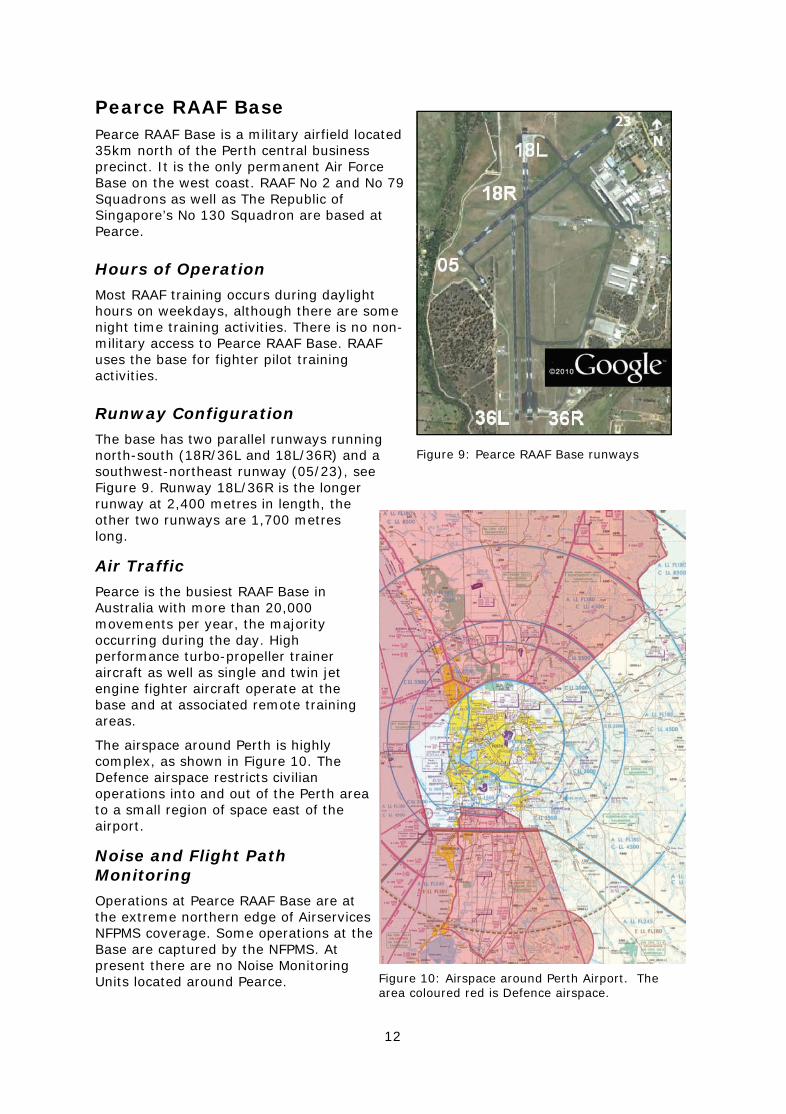
Pearce RAAF Base Pearce RAAF Base is a military airfield located 35km north of the Perth central business precinct. It is the only permanent Air Force Base on the west coast. RAAF No 2 and No 79 Squadrons as well as The Republic of Singapore’s No 130 Squadron are based at Pearce.
Hours of Operation
Most RAAF training occurs during daylight hours on weekdays, although there are some night time training activities. There is no non-military access to Pearce RAAF Base. RAAF uses the base for fighter pilot training activities.
Runway Configuration
The base has two parallel runways running north-south (18R/36L and 18L/36R) and a southwest-northeast runway (05/23), see Figure 9. Runway 18L/36R is the longer runway at 2,400 metres in length, the other two runways are 1,700 metres long.
Air Traffic
Pearce is the busiest RAAF Base in Australia with more than 20,000 movements per year, the majority occurring during the day. High performance turbo-propeller trainer aircraft as well as single and twin jet engine fighter aircraft operate at the base and at associated remote training areas.
The airspace around Perth is highly complex, as shown in Figure 10. The Defence airspace restricts civilian operations into and out of the Perth area to a small region of space east of the airport.
Noise and Flight Path Monitoring
Operations at Pearce RAAF Base are at the extreme northern edge of Airservices NFPMS coverage. Some operations at the Base are captured by the NFPMS. At present there are no Noise Monitoring Units located around Pearce.
Figure 9: Pearce RAAF Base runways
Figure 10: Airspace around Perth Airport. The area coloured red is Defence airspace.
13
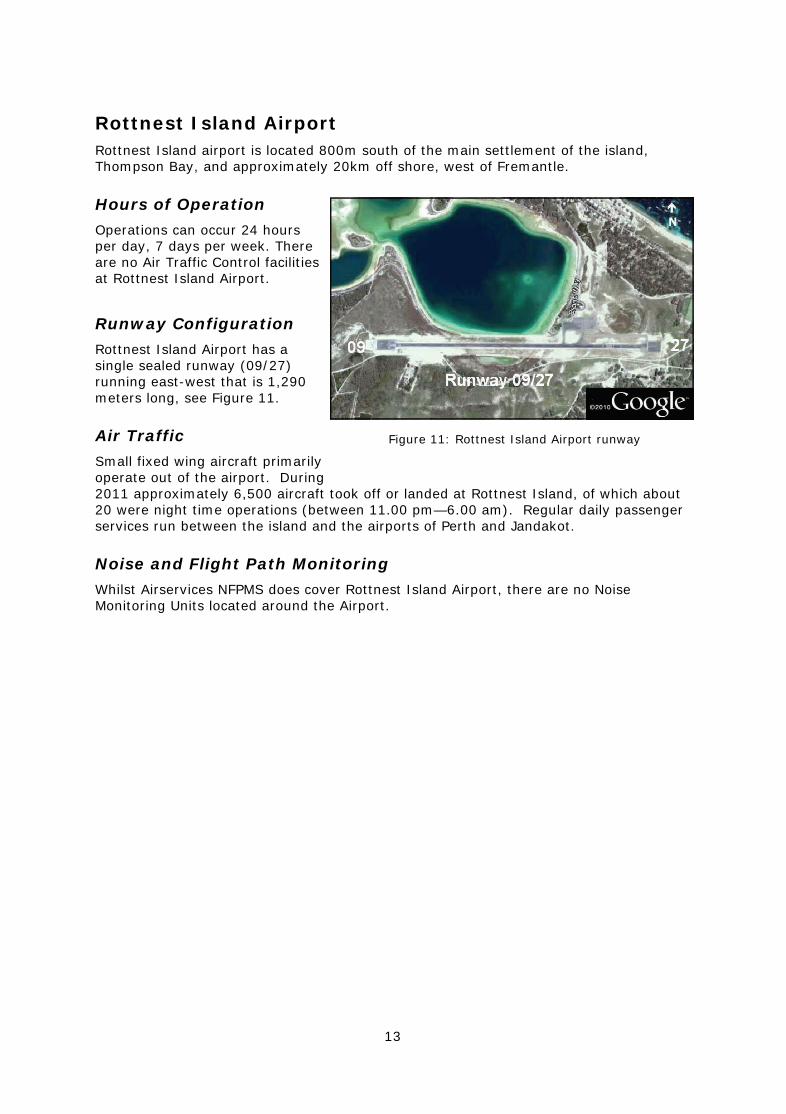
Rottnest Island Airport Rottnest Island airport is located 800m south of the main settlement of the island, Thompson Bay, and approximately 20km off shore, west of Fremantle.
Hours of Operation
Operations can occur 24 hours per day, 7 days per week. There are no Air Traffic Control facilities at Rottnest Island Airport.
Runway Configuration
Rottnest Island Airport has a single sealed runway (09/27) running east-west that is 1,290 meters long, see Figure 11.
Air Traffic
Small fixed wing aircraft primarily operate out of the airport. During 2011 approximately 6,500 aircraft took off or landed at Rottnest Island, of which about 20 were night time operations (between 11.00 pm—6.00 am). Regular daily passenger services run between the island and the airports of Perth and Jandakot.
Noise and Flight Path Monitoring
Whilst Airservices NFPMS does cover Rottnest Island Airport, there are no Noise Monitoring Units located around the Airport.
Figure 11: Rottnest Island Airport runway

14
Airservices Resources WebTrak
Airservices provides an internet based system called WebTrak which enables aircraft movements to be observed in near real-time at eight airports around Australia including Perth Airport (see Figure 12). Information on the site has a delay time of 40 minutes and can be viewed for the past three months. WebTrak provides information about individual aircraft such as aircraft type, altitude, destination and noise levels and presents this information on a map. WebTrak is available on the Airservices website at - http://www.airservicesaustralia.com/aviationenvironment/noise/webtrak/
Fact Sheets
Facts Sheets available on Airservices’ website contain information on commonly raised topics including management of complaint about aircraft noise, fundamentals of sound, circuit training and airport curfews: http://www.airservicesaustralia.com/aircraftnoise/airport-information/
Airservices Noise and Complaint Reports
Noise complaint and enquiry reports summarise the complaints received by Airservices Noise Complaints and Information Service (NCIS) for aircraft operations at Perth Airport. They include analysis of the issues of concern to NCIS clients, including any trends, and the number of clients raising the issues.
NFPMS reports provides technical information about aircraft noise and operations data collected by Airservices NFPMS.
Both reports can be found at:
http://www.airservicesaustralia.com/publications/reports-and-statistics/noise-reports/
Figure 12: Screen shot of WebTrak
15
Other Resources
Perth Airport
Provides information about aircraft noise in the vicinity of Perth Airport. http://www.perthairport.com.au/AboutUs/NoiseManagement.aspx
Noise Information Brochure
Details information on aircraft noise at Perth Airport.
http://www.perthairport.com.au/Files/Aircraft_Noise_Information_Brochure.pdf
Department of Infrastructure and Transport Website
Information on aircraft noise regulations, airport curfews, factsheets and aviation’s role in reducing carbon emissions is available from this website. This site also has a link to the Federal Government’s Aviation White Paper which details the Government’s aviation policy.
http://www.infrastructure.gov.au/aviation/
Civil Aviation Safety Authority Website
This site provides information on aircraft airworthiness and certification, airspace regulation and issues of aviation safety (for example the rules concerning low flying aircraft).
http://www.casa.gov.au/
Jandakot Airport Website
Provides information on the ‘Fly Neighbourly’ agreements, community consultation and operations at Jandakot airport.
http://www.jandakotairport.com.au/
Department of Defence
Outlines the noise complaints steps that can be taken to make a complaint about aircraft noise caused by aircraft operations at military airfields.
http://www.defence.gov.au/footer/contacts.htm#16