Embed Size (px)
Citation preview
Journal of the Korean Society of Surveying, Geodesy, Photogrammetry and CartographyVol. 32, No. 3, 271-279, 2014http://dx.doi.org/10.7848/ksgpc.2014.32.3.271
Performance Analysis of a Gravity Gradient Referenced Navigation System
Lee, Jisun 1)·Kwon, Jay Hyoun 2)
Abstract
As an alternative way to overcome the weakness of the global navigation satellite system (GNSS) in hostile situation, a gravity gradient referenced navigation (GGRN) has been developed. This paper analyzed the performance of GGRN with respect to the initial errors, DB resolution as well as update rates. On the basis of simulations, it was found that the performance of GGRN is getting worse when initial errors exist but the navigation results are rapidly converged. Also, GGRN generates better results when DB resolution is higher and update rates are shorter than 20 seconds. However, it is difficult to deduce the optimal parameters for the navigation because some trajectories show better performance in case low-resolution DB is applied or long update rate is supposed. Therefore, further analysis to derive specific update conditions to improve the performance has been performed. Those update conditions would not be generalized for all cases although maximum improvement rate is over 200% in certain case. In the future, some more developments and tests on the combination of various geophysical data and/or algorithms are necessary to construct more stable and reliable navigation system.
Keywords : Gravity Gradient, GGRN, EKF, Performance Analysis
271
ISSN 1598-4850(Print)ISSN 2288-260X(Online) Original article
Received 2014. 06. 02, Revised 2014. 06. 23, Accepted 2014. 06. 241) Member, Dept. of Geoinformatics, University of Seoul (E-mail : [email protected])2) Corresponding Author, Member, Dept. of Geoinformatics, University of Seoul (E-mail : [email protected])
This is an Open Access article distributed under the terms of the Creative Commons Attribution Non-Commercial License (http://creativecommons.org/licenses/by-nc/3.0) which permits unrestricted non-commercial use, distribution, and reproduction in any medium, provided the original work is properly cited.
1. Introduction
Recently, Global Navigation Satellite System (GNSS) is occasionally vulnerable to harsh environments, including signal jamming and solar storm, because the strength of the signal from the satellite is weak. For example, more than 1,400 GNSS receivers mounted on airplanes or ships were not working properly due to the jamming signal transmitted from the North Korea for the last three years. Korean Space Weather Center issued 3rd level solar warning alert 14 times in 2013 and five times so far this year (KSWC, 2014b). On January 8 2014, domestic airlines made a detour instead of polar route to avoid the largest solar storm since 2008 (KSWC, 2014a).
To overcome the weakness of GNSS, an alternative
method for determining accurate position and compensating for INS error is necessary. One such method is Database Referenced Navigation (DBRN) which uses certain geophysical information, such as gravity, magnetic, and terrain data, for navigation. Among DBRN methods, TRN techniques including terrain contour matching (TERCOM), Sandia inertial terrain-aided navigation (SITAN), and precise terrain-aided navigation (PTAN), have been studied from 1940’s. The position accuracy of these systems was known to be several tens of meters (Hollowell, 1990; Honeywell, 2005; Laur and Llanso, 1995). In recent years, the applicability of gravity gradient for navigation is rising due to the development of precise and small size gravity gradiometer. From mid 2000's, many papers deal with gravity gradient referenced navigation (GGRN) have been published

Journal of the Korean Society of Surveying, Geodesy, Photogrammetry and Cartography, Vol. 32, No. 3, 271-279, 2014
272
(DeGregoris, 2010; Liu et al., 2010; Richeson, 2008; Rogers, 2009). Because gravity gradiometer obtains five independent gravity gradients, GGRN is theoretically more beneficial and stable than other forms of DBRN (such as TRN) which uses only one measurement. Lee et al. (2014) modeled the gravity gradient and constructed GGRN algorithm based on an extended Kalman filter (EKF) for the first time in Korea. Then, simulation tests were conducted to evaluate the performance of the constructed GGRN with respect to DB/sensor errors, and altitude. The initial errors (i.e., position, velocity and attitude), DB resolution, and update rates are also affecting factors on the navigation performance. Especially, both DB resolution and update rates are related to the storage capacity and computation efficiency. In this study, therefore, the performance analysis in terms of initial errors, DB resolution, and update rates have been performed as a follow-up paper to Lee et al. (2014). In addition, a couple of update conditions were proposed and tested to improve the performance of the GGRN.
2. Methodologies
The purpose of this study is to analyze the effect of various factors into navigation results and to find a way to improve the navigation performance. Simulation tests were grouped into two stages; SimulationⅠdesigned to analyze the performance with respect to initial errors, DB resolution and updated rates. Firstly, 200 m horizontal and 15 m vertical initial position errors, 1 m/s horizontal and 2 m/s vertical velocity errors, and 0.1° roll and pitch error and 0.5° yaw error were supposed to check the influence of the initial errors on the navigation results. To ascertain the effects of these errors, the navigation results were compared with those obtained from no initial error conditions. Secondly, two different gravity gradient DBs (i.e., 9 arcsec and 60 arcsec resolution) were applied to determine the effect of DB resolution on the navigation performance. And, the simulation results were compared with those obtained from a traditional TRN. Lastly, the effects of update rates of 10 seconds, 20 seconds, and 50 seconds were analyzed.
Filter-based navigation can diverge or show poor performance when the slope of the physical data at the INS-
indicated position and that at the true position have different directions. In the simulation Ⅱ, two specific update conditions using the relation between filter measurements and DB/sensor errors, and the roughness of the gravity gradient were developed and tested to construct a more stable filter.
A series of tests has been performed based on the following settings to evaluate the navigation performance in respect of affecting factors and two updated conditions. It was assumed that an aircraft equipped with a navigation-grade INS, FTG gravity gradiometer, barometric altimeter sensor, and compass sensor. Also, six gravity gradient DBs were loaded into the aircraft navigation system. In the previous study, it was emphasized that DB and sensor errors in the GGRN should be the levels of 0.1 Eö and 0.01 Eö to obtain stable navigation results. Therefore, the DB and sensor errors were supposed to be 0.1 Eö and 0.01 Eö for whole simulation tests. For barometric altimeter and compass, 5 m and 5 deg error were applied. Here, the error of each sensor denotes the 1σ precision of the measurement. Then, the aircraft flies in a straight line with a speed of 350 km/h at an altitude of 3 km. As shown in middle of Fig. 1, a total of 14 trajectories (i.e., nine from south to north, four from west to east, and one from southwest to northeast) were generated. Please refer detailed sensor specification and algorithms in Lee et al. (2014).
The performance of the GGRN is evaluated on the basis of two-dimensional position errors with respect to the simulated true trajectories. The standard deviation of the horizontal error for whole trajectories is calculated using Eq.(1).
𝜎𝜎𝜎𝜎𝐻𝐻𝐻𝐻𝐻𝐻𝐻𝐻𝐻𝐻𝐻𝐻𝐻𝐻𝐻𝐻𝐻𝐻𝐻𝐻𝐻𝐻𝐻𝐻𝐻𝐻𝐻𝐻𝐻𝐻𝐻𝐻𝐻𝐻𝐻𝐻𝐻𝐻𝐻𝐻 = �∑(△ 𝑑𝑑𝑑𝑑 −△ 𝑑𝑑𝑑𝑑� )2
𝐻𝐻𝐻𝐻 − 1 (1)
△ 𝜑𝜑𝜑𝜑 △ 𝜆𝜆𝜆𝜆 △ 𝑑𝑑𝑑𝑑 △ 𝑑𝑑𝑑𝑑 = �△ 𝜑𝜑𝜑𝜑2 +△ 𝜆𝜆𝜆𝜆2, △ 𝑑𝑑𝑑𝑑� is
(1)
where,
𝜎𝜎𝜎𝜎𝐻𝐻𝐻𝐻𝐻𝐻𝐻𝐻𝐻𝐻𝐻𝐻𝐻𝐻𝐻𝐻𝐻𝐻𝐻𝐻𝐻𝐻𝐻𝐻𝐻𝐻𝐻𝐻𝐻𝐻𝐻𝐻𝐻𝐻𝐻𝐻𝐻𝐻𝐻𝐻 = �∑(△ 𝑑𝑑𝑑𝑑 −△ 𝑑𝑑𝑑𝑑� )2
𝐻𝐻𝐻𝐻 − 1 (1)
△ 𝜑𝜑𝜑𝜑 △ 𝜆𝜆𝜆𝜆 △ 𝑑𝑑𝑑𝑑 △ 𝑑𝑑𝑑𝑑 = �△ 𝜑𝜑𝜑𝜑2 +△ 𝜆𝜆𝜆𝜆2, △ 𝑑𝑑𝑑𝑑� is
and
𝜎𝜎𝜎𝜎𝐻𝐻𝐻𝐻𝐻𝐻𝐻𝐻𝐻𝐻𝐻𝐻𝐻𝐻𝐻𝐻𝐻𝐻𝐻𝐻𝐻𝐻𝐻𝐻𝐻𝐻𝐻𝐻𝐻𝐻𝐻𝐻𝐻𝐻𝐻𝐻𝐻𝐻𝐻𝐻 = �∑(△ 𝑑𝑑𝑑𝑑 −△ 𝑑𝑑𝑑𝑑� )2
𝐻𝐻𝐻𝐻 − 1 (1)
△ 𝜑𝜑𝜑𝜑 △ 𝜆𝜆𝜆𝜆 △ 𝑑𝑑𝑑𝑑 △ 𝑑𝑑𝑑𝑑 = �△ 𝜑𝜑𝜑𝜑2 +△ 𝜆𝜆𝜆𝜆2, △ 𝑑𝑑𝑑𝑑� is
are the position differences between GGRN estimated and true horizontal position in latitude and longitude, respectively,
𝜎𝜎𝜎𝜎𝐻𝐻𝐻𝐻𝐻𝐻𝐻𝐻𝐻𝐻𝐻𝐻𝐻𝐻𝐻𝐻𝐻𝐻𝐻𝐻𝐻𝐻𝐻𝐻𝐻𝐻𝐻𝐻𝐻𝐻𝐻𝐻𝐻𝐻𝐻𝐻𝐻𝐻𝐻𝐻 = �∑(△ 𝑑𝑑𝑑𝑑 −△ 𝑑𝑑𝑑𝑑� )2
𝐻𝐻𝐻𝐻 − 1 (1)
△ 𝜑𝜑𝜑𝜑 △ 𝜆𝜆𝜆𝜆 △ 𝑑𝑑𝑑𝑑 △ 𝑑𝑑𝑑𝑑 = �△ 𝜑𝜑𝜑𝜑2 +△ 𝜆𝜆𝜆𝜆2, △ 𝑑𝑑𝑑𝑑� is
is horizontal error which is calculated by
𝜎𝜎𝜎𝜎𝐻𝐻𝐻𝐻𝐻𝐻𝐻𝐻𝐻𝐻𝐻𝐻𝐻𝐻𝐻𝐻𝐻𝐻𝐻𝐻𝐻𝐻𝐻𝐻𝐻𝐻𝐻𝐻𝐻𝐻𝐻𝐻𝐻𝐻𝐻𝐻𝐻𝐻𝐻𝐻 = �∑(△ 𝑑𝑑𝑑𝑑 −△ 𝑑𝑑𝑑𝑑� )2
𝐻𝐻𝐻𝐻 − 1 (1)
△ 𝜑𝜑𝜑𝜑 △ 𝜆𝜆𝜆𝜆 △ 𝑑𝑑𝑑𝑑 △ 𝑑𝑑𝑑𝑑 = �△ 𝜑𝜑𝜑𝜑2 +△ 𝜆𝜆𝜆𝜆2, △ 𝑑𝑑𝑑𝑑� is
is mean of horizontal error, and n is the total number of epochs.
Fig. 1 shows summary of the simulation methodologies and environments. The construction DB/GGRN in Fig. 1 illustrates the specification of DB and sensors, and algorithms used for GGRN. The conditions of simulation tests are described in detail in the section of performance analysis.

Performance Analysis of a Gravity Gradient Referenced Navigation System
273
Fig.1. Summary of GGRN and methodologies of the study
Journal of the Korean Society of Surveying, Geodesy, Photogrammetry and Cartography, Vol. 32, No. 3, 271-279, 2014
274
3. Simulation Results
Before the analysis of simulation tests, it would be better to briefly explain the results obtained by the previous study.When aircraft flies with a precise gravity gradient DB and a gravity gradiometer (0.1 Eö and 0.01 Eö) at 3 km, the mean and the maximum horizontal error about 8 m and 15 m were obtained (Lee et al., 2014). It was supposed that the position and the attitude of the aircraft were updated every epoch. The results from the GGRN were better for 10 trajectories, which correspond to 70% of the test cases, compared with traditional TRN. The DB and sensor errors of TRN were supposed to 5 m and 10 m, respectively.
3.1 Simulation I : Analysis on the effects of
various factors
In GGRN, the gravity gradient values corresponding to the INS-indicated position are extracted from the gravity gradient DB when the measurements are obtained. Then, GGRN compensates the INS indicated position and attitude using the difference between the gravity gradient obtained from the gravity gradiometer and that obtained from the DB. Therefore, the reliability of the INS indicated position gives quite a large influence on the GGRN performance. In case initial position and attitude errors exist, position error would be much larger because the INS computes the current position, velocity, and attitude by integrating the IMU measurements based on the previous position, velocity and attitude. To check the stability and the convergence of the GGRN algorithm when initial errors exist, it was supposed that the aircraft started the flight at the wrong position, with wrong velocity and attitude. 200 m horizontal and 15 m vertical initial position errors, 1 m/s horizontal and 2 m/s vertical velocity errors, and 0.1° roll and pitch error and 0.5° yaw error were applied to the tests.
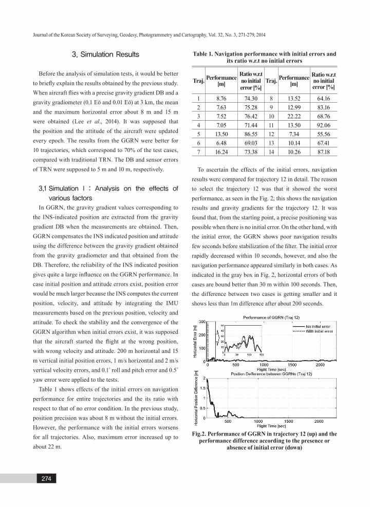
Table 1 shows effects of the initial errors on navigation performance for entire trajectories and the its ratio with respect to that of no error condition. In the previous study, position precision was about 8 m without the initial errors. However, the performance with the initial errors worsens for all trajectories. Also, maximum error increased up to about 22 m.
To ascertain the effects of the initial errors, navigation results were compared for trajectory 12 in detail. The reason to select the trajectory 12 was that it showed the worst performance, as seen in the Fig. 2; this shows the navigation results and gravity gradients for the trajectory 12. It was found that, from the starting point, a precise positioning was possible when there is no initial error. On the other hand, with the initial error, the GGRN shows poor navigation results few seconds before stabilization of the filter. The initial error rapidly decreased within 10 seconds, however, and also the navigation performance appeared similarly in both cases. As indicated in the gray box in Fig. 2, horizontal errors of both cases are bound better than 30 m within 100 seconds. Then, the difference between two cases is getting smaller and it shows less than 1m difference after about 200 seconds.
Fig.2. Performance of GGRN in trajectory 12 (up) and the performance difference according to the presence or
absence of initial error (down)
Table 1. Navigation performance with initial errors and its ratio w.r.t no initial errors
Traj. Performance[m]
Ratio w.r.t no initial error [%]
Traj. Performance [m]
Ratio w.r.t no initial error [%]
1 8.76 74.30 8 13.52 64.162 7.63 75.28 9 12.99 83.163 7.52 76.42 10 22.22 68.76 4 7.05 71.44 11 13.50 92.06 5 13.50 86.55 12 7.34 55.566 6.48 69.03 13 10.14 67.417 16.24 73.38 14 10.26 87.18
Performance Analysis of a Gravity Gradient Referenced Navigation System
275
In DBRN, a high-resolution DB is generally used to reflect the local variations in data for the navigation solution. However, a high-resolution DB is not always necessary, if the similar level of navigation performances can be obtained with the low-resolution DB. In this situation, using the low-resolution DB would be a better option in terms of the system storage capacity and computation efficiency. To determine the effect of the DB resolution on navigation results, two different gravity gradient DBs of 9 arcsec and 60 arcsec resolution were tested. Table 2 illustrates the navigation performance and its ratio with respect to the results referenced from the 30 arcsec DB. As expected, a better performance (except in the case of trajectory 9) appears when the high-resolution DB is used. Mean horizontal error in 9 arcsec resolution DB is 4.29 m and it is two times precise than the results obtained in 30 arcsec resolution.
However, the navigation performance does not always come poorly out with low-resolution DB, likely in the trajectory 9. The reason showing better result with low-resolution DB in trajectory 9 can be explained as follows. The key factor influencing the performance of DBRN is the preservation of linearity between measurements and states. If both true and INS-indicated positions are located on the same slope as the DB, linearity is guaranteed. However, these positions could be located on a different slope in the region when the data abruptly changes. In this situation, a better performance could be achieved when a lower resolution DB is applied because the irregular local variations become smooth in lower-resolution DB. Furthermore, both true and INS-indicated positions would refer to the same grid in a low-resolution DB if the position difference was relatively small.
Additionally, the navigation results with different resolution DB were compared with those obtained from TRN. In the case of the 9 arcsec resolution DB, total 13 trajectories showed better performance than TRN. It is notable improvement considering the navigation results based on 30 arcsec resolution DB because it showed better performance in 10 trajectories. In other words, 3 trajectories showed better performance due to use of high resolution DB. However, only 3 trajectories show better results in 60 arcsec resolution DB compared to the results from TRN. It can be interpreted as the DB resolution makes quite large impacts
on the navigation performance. Therefore, it is advisable using the high-resolution DB for the navigation to obtain stable performance.
Last affecting factor on the navigation performance is update rates. In general, geophysical sensors obtain the data every epoch. It would be unrealistic to update the INS position and attitude at every epoch if additional processing is applied to minimize the environmental errors on the measurements. For the similar perspective of the DB resolution, it would not be necessary to compensate the INS errors every epoch when similar navigation results appear with longer update rates. To analyze the influence of the update rates, 3 different update rates such as 10 seconds, 20 seconds, and 50 seconds were supposed. It should be reminded that the aircraft flies with the speed of 350 km/h, thus the above update rates assure to extract gravity gradient information at new grid at every update epoch. The 30 arcsec resolution DB was used for this test. Table 3 shows the performance and its ratio with respect to the results generated by updating the INS position and attitude every epoch. When the update rate of 10 seconds applied, the mean horizontal position error of about 7 m is obtained and all trajectories show better performance.
Table 2. Navigation performance in 9 arcsec and 60 arcsec DB and its ratio w.r.t 30 arcsec DB
Traj.Performance [m] Ratio w.r.t 30 arcsec [%]
9 60 9 60
1 3.24 12.33 201.14 52.77 2 3.21 9.39 179.16 61.22 3 3.85 9.47 149.13 60.66 4 2.70 6.25 186.36 80.60 5 7.86 18.17 148.55 64.28 6 3.42 8.50 130.99 52.65 7 4.59 25.07 259.82 47.55 8 3.93 17.55 220.80 49.43 9 5.20 10.50 207.52 102.82 10 6.52 45.08 234.38 33.8911 6.01 19.73 206.85 63.00 12 3.84 9.90 106.23 41.19 13 2.55 7.54 268.22 90.62 14 3.20 10.34 279.57 86.57

Journal of the Korean Society of Surveying, Geodesy, Photogrammetry and Cartography, Vol. 32, No. 3, 271-279, 2014
276
However, navigation performance is getting worse when the update rates become longer.
The reason for the better performance with the 10 seconds update rate is that this rate assures to use the gravity gradient values in different grid which reduces the risk of wrong error compensation caused by the broken of the linearity between the measurement and states. In other words, the update of every second has ten times higher risk than that of the 10 seconds if a wrong compensation occurs. Of course, the possibility of the wrong compensation gets higher at flat area
where the difference between the measured and extracted values is small and sometimes is within the error range.
However, horizontal errors would be larger if update rates became longer. This is basically due to the broken of the linearity between the measurements and states. That is, position could not be compensated properly because INS indicated position is too far away from the true position when update rate is too long. Once wrong correction is made, the aircraft flies to the wrong direction until the next update. In this situation, the filter would be diverged because the possibility of non-linearity between measurements and states gets higher. To check the effect of the update rates in more detail, the navigation results have been compared in trajectory 7. The reason to select trajectory 7 is that this trajectory shows better performance for all test cases despite longer update rate than the result obtained by every epoch update. Fig. 3 illustrates the navigation results and the gravity gradient variation in trajectory 7. As mentioned before, horizontal error increases at the flat area due to the difficulty of finding appropriate correction direction and its magnitude. In trajectory 7, not much variation in gravity gradients appears for the first few hundred seconds. This causes very large position errors if the position is updated every second. However, it was found that navigation results except the case of 50 seconds update rate show similar performance after filter convergence. On the other hand, after 500 seconds flight time, the horizontal error is still larger than 30 m in case of 50 seconds update rate. This analysis clearly illustrates that the update rate should be carefully decided with a consideration of changing the update rate adaptively reflecting the characteristics of the flight area.
Fig.3. Navigation performance in terms of update rates in trajectory 7 (up) and variation of gravity gradient (down)
Table 3. Navigation performance in terms of update rates and w.r.t every epoch update
Traj.Performance [m]
10 20 501 5.07 6.76 11.90 2 5.21 6.41 9.29 3 5.19 7.45 12.34 4 4.20 6.35 11.16 5 10.57 11.54 23.36 6 4.41 4.75 10.26 7 7.73 8.62 11.64 8 6.01 7.25 6.50 9 9.85 10.94 9.77 10 13.17 27.18 48.85 11 11.98 19.98 35.39 12 3.59 5.42 9.66 13 5.78 6.18 17.44 14 6.51 7.71 10.38
Traj.Ratio w.r.t. every epoch update [%]
10 20 501 128.40 96.33 54.69 2 110.34 89.65 61.86 3 110.77 77.13 46.53 4 120.10 79.40 45.17 5 110.46 101.26 50.00 6 101.39 94.26 43.62 7 154.17 138.37 102.43 8 144.22 119.62 133.48 9 109.68 98.72 110.54 10 116.03 56.21 31.28 11 103.78 62.21 35.13 12 113.58 75.19 42.21 13 118.32 110.66 39.1914 137.36 116.08 86.19

Performance Analysis of a Gravity Gradient Referenced Navigation System
277
3.2 Simulation Ⅱ: Analysis of update condition
As shown in the previous section, various factors make an effect on the navigation performance. Therefore, it is impossible to deduce an unique value for each factor which generates the optimal result. For example, the trajectory 9 shows the best navigation with the 50 seconds update rate. However, the worst performance is shown in trajectory 10 with the same condition. The key of EKF to assure precise navigation is the linearity between measurements and states. If the linearity is preserved, the GGRN correctly compensates the INS errors. Otherwise, a wrong correction is applied to the solution. Unfortunately, it would not be easy to figure out whether the linearity is preserved or not because we do not know the true position at the update time. Therefore, one has to try to reduce the possibility of wrong correction using some conditions.
In this study, two specific update conditions were developed and tested. The first condition has been deduced with a consideration of the relation between the filter measurements and DB/sensor errors. If the filter measurement (i.e., the difference between gravity gradiometer measurement and extracted gravity gradient from DBs) is smaller than the DB/sensor error, one cannot consider it as the filter measurement. Therefore, a condition would be set as the filter compensates the INS errors when the measurements are larger than the error calculated in combination with DB and sensor error. The purpose of this condition was to determine a specific update interval, so that full gravity gradients were used for the navigation in update time. The concept of the second condition is the selection and the use of part of the gravity gradient DBs. In general, worse navigation results appear in flat area, so that it would be better to use some gravity gradient DBs showing large variation. Based on this idea, only the selected gradient components were used to compensate the INS errors when the calculated standard deviation at the update time is larger than 10% of the one from whole area. For both cases, aircraft flies without update when update condition is not satisfied. Also, aircraft does not compensate the INS errors when the total number of selected DB is only one in update condition 2.
To evaluate the above two update conditions, simulation
tests were conducted in the same trajectories. DB and sensor errors were applied to 0.1 Eö and 0.01 Eö respectively, and gravity gradient DB of 30 arcsec resolution was used. Table 4 indicates the performance and its ratio with respect to the results obtained without update condition. As a result, 4 and 5 trajectories show improved navigation results respectively, when update conditions were applied.
In the case of the update condition 1, the trajectory 4 shows the most improved result with the ratio of 119%. During the entire flight, the trajectory 4 updates the position and the attitude only 1,071 times, which is only 31% of the total update time. When update condition 2 was applied, the most improved case was found in the trajectory 7. Among a total of 3,430 update times, it compensates the INS error 1,385 times with full tensor gravity gradients. Except 1,385 times, 5, 4, 3, and 2 components were used 698, 384, 324, and 274 times, respectively. Because the number of selected DB was one, aircraft flew without the update for 365 times.
It should be noted that it is difficult to generalize those update conditions to be applicable in all the cases although some trajectories showed significant improvement. However, it is expected that such update conditions would be useful at the stage of flight planning to construct more effective and accurate navigation strategy.
Table 4. Navigation performance in terms of update conditions and its ratio w.r.t without update condition
Traj.Performance [m]
with conditionRatio w.r.t without
update condition[%]1 2 1 2
1 9.08 9.56 71.68 68.07 2 6.21 6.48 92.58 88.68 3 6.21 6.39 92.46 89.90 4 4.23 4.79 119.03 105.23 5 14.88 5.88 78.48 198.74 6 4.87 5.85 91.92 76.47 7 10.58 5.93 112.65 201.11 8 8.11 10.56 106.91 82.139 14.41 7.58 74.91 142.50 10 16.64 11.36 91.81 134.47 11 13.52 97.30 91.96 12.78 12 4.68 4.39 87.02 92.94 13 9.30 11.27 73.48 60.65 14 8.55 12.31 104.69 72.66

Journal of the Korean Society of Surveying, Geodesy, Photogrammetry and Cartography, Vol. 32, No. 3, 271-279, 2014
278
4. Conclusion
In order to investigate impact of the GGRN filtering conditions (e.g., initial errors, DB resolution, and update rates) into their positioning accuracy, a series of simulation analysis has been carried out in this study. It was found that the better performance was achieved when no initial errors were supposed. However, the effect of initial error appeared mostly at the starting zone only, and performance was significantly improved once the filter was converged. Although better navigation results are generally expected when the DB resolution is higher, the navigation using the low-resolution DB shows better performance when the data abruptly changes. This is because the linearity between the observations and the states is broken.
The best navigation results were obtained when 10 seconds update rate was applied. It seems that the 10 seconds update assures to use the gravity gradient information in difference grid so that it reduces the risk of wrong compensation. Therefore, it is crucial to find an appropriate update rate to achieve better performance in the GGRN navigation.
To improve the navigation performance, two update conditions were developed and tested. Among 14 trajectories, about 30% of trajectories generated better results with respect to the case without the update conditions. Although it is difficult to generalize the condition to be suitable for all cases, it is meaningful due to the fact that the maximum performance improvement rate could be about 200%.
Therefore, those conditions would be applied in the stage of planning to design effective navigation system. In future, the combination of various geophysical data and/or algorithms is required to support more stable and precise navigation.
Acknowledgement
This work was supported by the 2013 Research Fund of the University of Seoul
References
DeGregoria, A. (2010), Gravity Gradiometry and Map
Matching: An Aid to Aircraft Inertial Navigation Systems, Master’s thesis, Graduate School of Engineering and Management, Air Force Institute of Technology, Wright-Patterson AFB, OH, USA, 130p.
Hollowell, J. (1990), HELI/SITAN: A terrain referenced navigation algorithm for helicopter, Proceedings of IEEE Position Location and Navigation Symposium, IEEE, 20-23 March, Las Vegas, NV, USA, pp. 616-625.
Honeywell (2005), Precision Terrain Aided Navigation (PTAN), Honeywell International Inc., New Jersey, NJ, USA, http://www.honeywell.com/sites/servlet/com.merx.npoint.servlets. DocumentServlet ?docid=D01BFCE4D-78D2-A2C0-D1D9-115FAEC2DCE7 (last date accessed: 24 January 2014).
KSWC (2014a), Status Report of 3rd Level Solar Storm on January 8 2014, Korean Space Weather Center, Jeju Special Self-Governing Province, http://www.spaceweather.go.kr/notification/notice/84 (last date accessed: 29 May 2014).
KSWC (2014b), Status Report of 3rd Level Solar Storm on April 25 2014, Korean Space Weather Center, Jeju Special Self-Governing Province, http://www.spaceweather.go.kr/notification/notice/92 (last data accessed: 29 May 2014).
Laur, T.M. and Llanso, S.L. (1995), Encyclopedia of Modern U.S. Military Weapons, The Army Times Publishing Company with Berkley Publishing Group, New York, NY, USA, 496p.
Lee, J.S., Kwon, J.H., and Yu. M. (2014), Development of gravity gradient referenced navigation its horizontal accuracy analysis, Journal of the Korean Society of Surveying, Geodesy, Photogrammetry and Cartography, Vol. 32, No. 1, pp. 1-8. (in Korean with English abstract)
Liu, F., Qian, D., Zhang, Y., and Li, Y. (2010), A computer simulation of the influence of GGI and inertial sensors on gravity gradient aided navigation, Proceedings of 2010 International Symposium on Systems and Control in Aeronautics and Astronautics, ISSCAA, 8-10 June, Harbin, China, pp.793-797.
Richeson, J.A. (2008), Gravity Gradiometer Aided Inertial Navigation Within Non-GNSS Environments, Ph. D. dissertation, University of Maryland, College Park, MD, USA, 405p.
Rogers, M.M. (2009), An Investigation into the Feasibility of

Performance Analysis of a Gravity Gradient Referenced Navigation System
279
Using a Modern Gravity Gradient Instrument for Passive Aircraft Navigation and Terrain Avoidance, Master’s thesis, Graduate School of Engineering and Management, Air Force Institute of Technology, Wright-Patterson AFB, OH, USA, 164p.


![[REDACTED] ENSR - PLATTEVILLE AQUIFER GRADIENT CONTROL … · 2020. 12. 14. · referenced case, enclosed is the "Platteville Aquifer Gradient Controi Well W434 Wellhouse Construction](https://img.dokumen.tips/doc/110x75/60fc82c0879c8a2f735d6af5/redacted-ensr-platteville-aquifer-gradient-control-2020-12-14-referenced.jpg)