Embed Size (px)
Citation preview

Perched Ponds: An Arctic Variety
H. J. WALKER and M. K. HARRIS
ABSTRACT. Data obtained during several seasons of field research on a small drainage basin in the Colville River delta of northern Alaska were used in a study of permafrost as an aquaclude for the maintenance of a pond above the regional water table. The development of the active layer of permafrost in the basin and the water budget of the pond were monitored. It was shown that the permafrost table enables the general form of the basin's subaerial surface to be maintained throughout the thaw season. The resulting prevention of percolation, when combined with a low evaporation rate, is sufficient to ensure that the pond is perennial.
RkSUMI?. &tangs sur4levés: une varikt4 arctique. Des données obtenues au cours de plusieurs saisons de recherches sur les lieux d'un petit bassin de drainage dans le delta de la rivikre Colville dans l'Alaska du Nord furent utilisées pour maintenir un étang au-dessus du niveau hydrostatique régional en se servant du pergélisol pour enfermer l'eau. Le développement de la couche active du pergélisol dans le bassin et la quantité d'eau de l'étang furent contrôlés et enregistrés. Il fut dhont ré que le niveau du pergélisol permet & la forme générale de la surface subaérienne du bassin de rester stable pendant toute la saison du dégel. L'absence d'infiltration qui en résulte, lorsqu'elle est combinée avec un taux bas d'évaporation, est suffisante pour assurer la perpétuité de l'étang.
INTRODUCTION
The Coastal Plain of northern Alaska is characterized by continuous permafrost, a thin active layer, a short snow-free period, cool summers, low evaporation rates, and tundra vegetation. Further, it possesses low-gradient slopes which, in combination with the above conditions, cause poor drainage and account for the numerous lakes and ponds characteristic of the region (Walker 1974). Lakes vary greatly in number and size across the Coastal Plain; in some regions they occupy as much as 90% of the surface area (Brewer 1958).
Thaw lakes, especially the oriented variety, have been studied by a number of researchers (Hopkins 1949; Carson and Hussey 1959; Hussey and Michelson 1966; Sellman et al. 1975). However, the other types of lakes in the Alaskan Arctic have been virtually ignored. In the glaciated portions of the Brooks Range

224 PERCHED PONDS
and Foothills glacial lakes are numerous (Hobbie 1974); along most rivers and in most deltas typical floodplain lakes are common (Walker 1974); and the centres of, and troughs between, ice-wedge polygons are frequently occupied by water.
A type of Arctic pond that has received little attention to date is one that exists in the sand dunes of the North Slope (Walker 1967). It might be considered an Arctic member‘of the family of perched lakes, which are common in many parts of the world.
Perched lakes Veatch and Humphreys (1964 p. 164) defined a perched lake as “. . . a perennial
lake which has a surface level lying at a considerably higher elevation than that of other waterbodies directly adjacent or closely associated.” In order for perched lakes to exist, an aquaclude must be present between the water table associated with the lake and the regional water table. Such aquacludes have been described many times and include glacial till (Veutch et ai. 1906), impervious clays (Stearns et al. 1939), humus-bound sand (“coffee rock”) and aeolianite (Jedngs 1957), organic cemented sand (Coaldrake 1960), glacial ice (Ricker 1962), playa clays (Motts 1965), and humate (Swanson and Palacas 1965), to mention but a few. Permafrost, the aquaclude discussed in this paper, contrasts with the other types just referred to, with the possible exception of glacial ice, in that its presence depends upon the temperature regime of, the lake site rather than depositional history.
PERMAFROST, THE ACTIVE LAYER, AND ARCTIC LAKES
Permafrost, defmed as any material in which the temperature has remained continuously below 0°C for two or more years (Muller 1947), “. . . acts as an impermeable barrier to the movement of ground water, because the pore spaces are generally iilled with ice within the zone of saturation” (Williams 1970 p. 2). Recharge, discharge, and movement of ground water are restricted, and therefore permafrost provides the potential for perching. Nonetheless, to date, the aquaclude nature of permafrost has not been singled out as a perching mechanism.
All of the North Slope is in the zone of continuous permafrost, .+.e., in the zone where climatic conditions are such that regionally the ground temperature remains continuously below 0°C. The only surface areas within this region not underlain by permafrost are those where deep bodies of water are present (for example, beneath deep river channels and deep lakes). In these locations there is a thaw bulb which may extend through the permafrost to the non-frozen layers beneath (Lachenbruch et al. 1962). The size and thickness of these non-permafrost zones depend on the dimensions of the water bodies and their age. On the average, water on the North Slope freezes to depths of two metres during winter. Water bodies deeper than 2-3 metres do not freeze to the bottom.
The active layer is an integral part of permafrost environments and is the layer which seasonally thaws and freezes. Its base is a permafrost table that may vary in depth slightly from year to year in response to climatic conditions. In any event, in the zone of continuous permafrost the concept of a regional water table has

PERCHED PONDS 225
little significance, for ground-water flow is limited to movement in the active layer (usually never more than two metres thick on the North Slope) during the few months of summer. Thus, most lakes, regardless of size, have essentially their own water table.
Permafrost effectively isolates nearly all lakes on the North Slope. The duration and abundance of lakes can be attributed mainly to the inhibited drainage caused by permafrost and to the relatively low levels of evaporation. Thaw lakes (the type of Arctic lake that has received the greatest attention to date) develop as a result of the subsidence that follows thawing of the permafrost (Hopkins 1949). In contrast, perched lakes, as discussed in this paper, develop when permafrost forms in a basin.
SAND DUNES AND PERCHED LAKES
Most lakes in the tundra do not have a surface level lying at a considerably higher elevation than adjacent waterbodies, as required by the definition of perched lakes quoted above. For such a condition to exist, a highly irregular local relief is necessary - a relief such as is found in moraine or dune topography. Moraine topography is conhed to the Foothills section north of the .Brooks Range and is not present on the Coastal Plain. However, the Coastal Plain does contain numerous sand dune areas in which local relief may reach ten metres (Black 195 1 ; Walker 1967).
Sand dunes are best developed along rivers or in association with large lakes. The prevailing winds on the Coastal Plain are from the northeast, so that dune areas tend to be found on the southwestern sides of river channels and lakes. The size of the dunes is mainly determined by the size of the sand bars upwind of the dune area.
Some of the best developed dunes to be found in northern Alaska are in the Colville River delta, where they line much of the left bank of most of the delta’s distributaries (Fig. 1) (Ritchie and Walker 1974). Stabilized and active dunes are both present, but the active dunes possess the greater amount of local relief. Stabilized dunes are covered with vegetation, have generally smooth, rounded shapes, and have few depressions in which water can accumulate. In contrast, active dunes possess a highly irregular relief and provide two types of closed basin: one, the interdune basin, which develops as a dune field moves inland from a river bar, is elongated parallel to the sand field, while the other develops within a dune field where blowouts are common. These blowout basins are usually elongated parallel to windflow, i.e., nearly perpendicular to the orientation of the dune field (Fig. 2), and are referred to as intradune basins (Walker 1967).
Delta dunes consist mainly of fine or very b e sand, although coarse sand and even fine gravel occur in the bowls of some of the blowouts. Organic matter is minimal, although willow roots and the roots of a variety of grasses help bind the sand in place.
In the Colville Delta nearly every dune system has both types of basin, and many of these contain ponds. Within 50 metres of Camp Putu (one of the field stations operated by the Naval Arctic Research Laboratory, Barrow, Alaska),
226 PERCHED PONDS
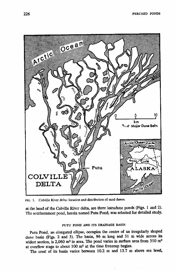
FIG. 1. Colville River delta: location and distribution of sand dunes.
at the head of the Colville River delta, are three intradune ponds (Figs. 1 and 2). The southernmost pond, herein named Putu Pond, was selected for detailed study.
PUTU POND AND ITS DRAINAGE BASIN
Putu Pond, an elongated ellipse, occupies the centre of an irregularly shaped dune basin (Figs. 2 and 3). The basin, 96 m long and 31 m wide across its widest section, is 2,060 m2 in area. The pond varies in surface area from 310 m2 at overflow stage to about 100 m2 at the time freezeup begins.
The crest of its basin varies between 10.2 m and 13.7 m above sea level,

PERCHED PONDS 227
FIO. 2. Camp Putu and intradune ponds. The overflow drainage channel is indicated by “a*’.
FIQ. 3. Map of Putu Pond and basin.
the lowest edge being about 6 m above the mudflat at the base of the dunes, 15 m away. The lowest part of the basin is 9.2 m above sea level, and maximum relief is more than 4 m. Pond depth varies during the summer between about 0.6 m and 1.3 m at the pond’s deepest spot.
The surface of the basin slopes, with various degrees of steepness, toward the

228 PERCHED PONDS
pond. Its surface is covered with a highly varied vegetation ranging from thick mats of moss, through grasses and flowering plants, to willows which, especially at the western end of the pond, are as much as 2 m tall (Fig. 4). Part of the surface is non-vegetated, although such areas often contain roots from adjacent plants. In this dune belt, willow roots occasionally extend horizontally more than 10 m just beneath the surface. The dune area is colonized by ground squirrels, which play a very important role in dune modification. Occasional caribou herds move across the surface, and birds frequently nest within the basin.
Virtually all characteristics of the pond and its basin are affected by the extreme seasonality that is typical of the Arctic. There are four periods of highly varied duration. During most of the year the basin is covered with a layer of snow and the pond and active layer are frozen. This period, winter, lasts between seven and eight months. Spring, the season of melting snow and ice within the basin, is short, lasting less than a month. Summer, which is characterized mainly by a gradual lowering of pond level and a gradually decreasing rate of active-layer development, extends from about mid-June to mid-September. Fall, like spring, is short and is the period during which the pond freezes and the snow cover begins to form.
From the standpoint of perching, the two most distinctive changes that occur within the basin are the development of the active layer and the seasonal water- budget cycle. Although in nature these two phenomena are not mutually exclusive, in this report they are separated for clarity of presentation.
DEVELOPMENT OF THE ACTIVE LAYER
Restricted thawing of the active layer in the basin ensures maintenance of the pond throughout the summer season. In order to monitor active-layer development,
Sand NO VEGETATION
Wittows DUNE VEGETATION
Mosses Grasses
WATER VEGETATION Coltho palustris Carex aquatilis
FIG. 4. Biotic maps, Putu Pond and basin.

PERCHED PONDS 229
depth measurements were made with a two-metre-long probe once a week at intervals of 1.5 m along six sections (Fig. 3) across the basin and three additional shorter sections across the pond.
Initiation of thaw appears to occur within a few hours of the hal removal of snow from the surface. From the monitoring of test plots on sand dunes during the snowmelt period it was shown that as long as snow is present, even though air temperatures may be quite high, the sand will thaw no more than a few centimetres (Fig. 5) . In the drainage basin of Putu Pond, the snow first disappears from the south-facing, steep slopes of non-vegetated sand. Removal occurred in some areas in early May; the last snow did not melt from beneath some willows near the head of the pond until over a month later. Thus, initiation of active-layer thaw ranges over a month in the basin.
0 I I I I I I 1 2 3 4 5 6 m
FIG. 5. Snowmelt and dune thaw with time (in hours) along a 6-metre section on a flat, bare surface, 23-26 May 1971.
In Fig. 6, the development of the active layer is illustrated for the third of the six sections for 1962. All six sections displayed a similar trend for the other years in which data were collected (1964, 1966, 197 1, and 1973). Along the third section in 1962, there was great variation in the date when the active layer reached

230
rn
l4 r
PERCHED PONDS
a. Overflow level
specific depths. For example, the date when the active layer had thawed to a depth of 20 cm ranged from 12 May under exposed sand surface to 13 June beneath the lake. The mean comparable date beneath moss- and willow-covered surfaces was 5 June. An active-layer thickness of one metre was reached on the southward-facing portion of the section under sand by mid-June, whereas such thickness never occurred beneath the pond.
In order to determine the relative rates of development, as between different areas within the basin, active-layer thaw values for all probes were divided into groups on the basis of surface cover (exposed sand, willow, moss, or water). It was found that beneath all types of cover the seasonal variation of thaw is similar in that, once thaw is initiated, it progresses rapidly until about the end
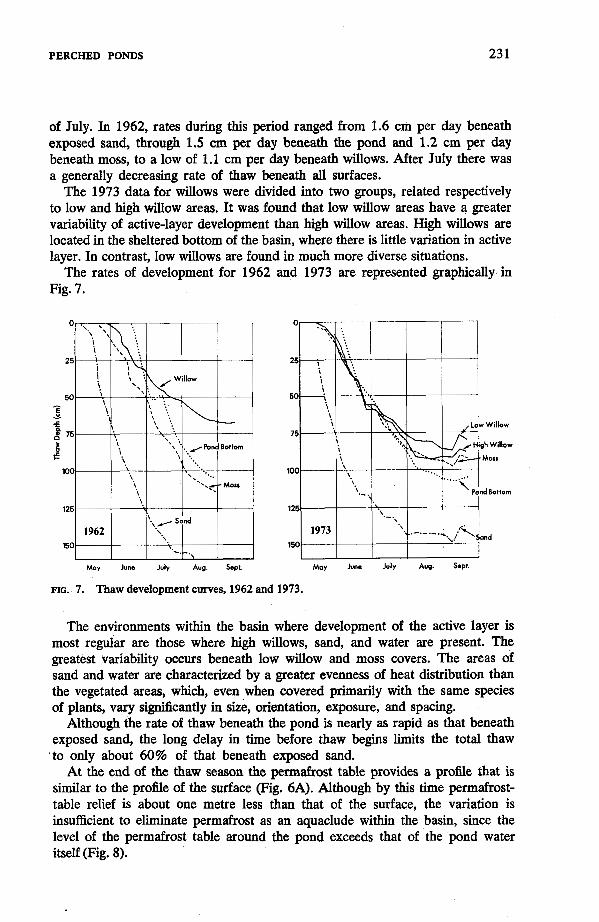
PERCHED PONDS 23 1
of July. In 1962, rates during this period ranged from 1.6 cm per day beneath exposed sand, through 1.5 cm per day beneath the pond and 1.2 cm per day beneath moss, to a low of 1.1 cm per day beneath willows. After July there was a generally decreasing rate of thaw beneath all surfaces.
The 1973 data for willows were divided into two groups, related respectively to low and high willow areas. It was found that low willow areas have a greater variability of active-layer development than high willow areas. High willows are located in the sheltered bottom of the basin, where there is little variation in active layer. In contrast, low willows are found in much more diverse situations.
The rates of development for 1962 and 1973 are represented graphically in Fig. 7.
May June July Aug. Sept. May June July Aug. Sept.
FIG. 7. Thaw development curves, 1962 and 1973.
The environments within the basin where development of the active layer is most regular are those where high willows, sand, and water are present. The greatest variability occurs beneath low willow and moss covers. The areas of sand and water are characterized by a greater evenness of heat distribution than the vegetated areas, which, even when covered primarily with the same species of plants, vary significantly in size, orientation, exposure, and spacing.
Although the rate of thaw beneath the pond is nearly as rapid as that beneath exposed sand, the long delay in time before thaw begins limits the total thaw to only about 60% of that beneath exposed sand.
At the end of the thaw season the permafrost table provides a proiile that is similar to the profile of the surface (Fig. 6A). Although by th is time permafrost- table relief is about one metre less than that of the surface, the variation is insufficient to eliminate permafrost as an aquaclude within the basin, since the level of the permafrost table around the pond exceeds that of the pond water itself (Fig. 8).

232
FIG. 8. Relation between thaw m depth in sand surrounding Putu Pond and water level (metres above mean sea level). ' ' r \ Base of thaw layer
10.51 \ r d sand
PERCHED PONDS
I I I I I I 0 25 50 75 l o o 125 1 5 0
ELAPSED DAYS
PUTU POND WATER BUDGET
Whereas the presence of a permafrost table which parellels the surface contours of the dunes is responsible for providing the aquaclude needed for perching, it is the nature of the water budget in the basin that ensures adequate water for maintenance of the pond. The several factors involved include snow accumulation during winter, sublimation of snow, runoff from the basin, temperature and evaporation, precipitation during summer, and lateral movement of water through the sand above the aquaclude.
Snow and ice Measurements of depth and density of snow were taken during several seasons
in Putu basin. The irregular surface of the basin results in an uneven distribution of snow (Fig. 6A). Even in midwinter, the snow is shallow along the crest, some portions of which are occasionally clear of it. Drifts accumulate to thicknesses of 1.75 m in the basin where, by midwinter, the amount of snow reaches nearly equilibrium conditions, with densities averaging 30-40%. The variability of snow density with depth, which is low in winter, increases as the melt season proceeds (Table 1).
In 1971, the quantity of snow remained basically the same until mid-May, when melting, evaporation, and sublimation began to increase in intensity (Table 2). During thaw, meltwater percolated down through the snow; much of it refroze in the bottom layers, and an increase in density resulted (Table 2). In 1962, prior to snowmelt, the basin contained 1,240 m3 of snow at an average density of 37% for a water equivalent of 459 ma.
The quantity of ice in the pond varies from year to year, depending upon water depth at the time of freezeup. In 1971, the volume of ice was 21 m3. Melting of pond ice is delayed because it is protected by the snow cover for many days (Fig. 6B).
Overflow Although much of the initial meltwater percolates into the snow and refreezes?

233
TABLE 1. Snow density and depth over pond centre
24 May 1971 13 May 1973
Depth Density Depth Density (cm) ( %) (cm) ( %) 5 42 5 40 20 39 20 42 35 34 50 45 65 49*
35 36 50 39 65 36 80 33 ’ 95 39
*Refrozen’ melted snow
TABLE 2. Snow characteristics, 1971
Volume Average density Water equivalent (m9 ( %) (ma)
25 April 948 33 312 15 May 896 36 323 23 May 457 46 210
it eventually begins to accumulate at the bottom of the pack. In the case of Putu Pond, meltwater gradually increases in depth at the base of the snow, especially on the surface of the ice. As the snow melts, the layer of water eventually reaches a level at which overflow occurs. The date on which overflow is initiated, and the duration of overflow, vary with the quantity of snow in the basin and with the nature of the temperature-and-precipitation regime during the melt season (Table 3). Overflow usually lasts less than two weeks.
Daily variations in flow correlate closely with temperature changes (Fig. 9). In 1971, for example, during the first two days of overflow (28-29 May) only about 6.5 ms were discharged. On neither day did the air temperature rise above 0°C. However, on 30 May the temperature reached 7OC and the discharge
TABLE 3. I Overflow characteristics
MaXimum Total
Year began ceased snow or tce (litrelmin.) (ms) 1962 29 May 14 June 18 June X X 1964 X 3 June 15 June X X 1966 X 14 June 19 June X X 1971 28 May 9 June 14 June 20 62.3 1973 28 May 12 June 12 June 13 43.9 X - Not observed
Date flow Date flow Date of last discharge discharge

234
-
PERCHED PONDS
I l0C L \ I I / \ I
Air Temperature- - 20
- 15 I4
5 -10 2 - 5 6 - 0
, " 5
28 29 30 31 1 ~~
2 3 4 5 6 7 8
M A Y JUNE
FIG. 9. Relation between air temperature ("C) and pond discharge (litres per minute), 1971.
reached 19 litres per minute (total for the day over 10 m3). The effect daily temperature has on overflow rates is well exemplified by records for 1 June. The temperature dropped below 0°C in the early morning and rose only a few degrees during the day. The overflow rate normally lags 1-3 hours behind temperature during high discharge and 4-5 hours during low discharge. The concentration of the bulk of the runoff within 2-4 days (Fig. 9) is representative in miniature of the regional hydrologic regime.
According to water-budget calculations for the basin for 1971, of the water available from snow and ice, 18% was lost by overflow and 45% by sublimation, evaporation, or percolation (Table 4). The amount of water perched in the basin at the end of the overflow period in 1971 was 126 m3, or 37% of the potential. The 153 m3 loss, caused mainly by sublimation, appears reasonable in that actual calculation of the water equivalent of snow five days before drainage began (23 May) showed that a loss of 113 ma had already occurred (Table 2).
Summer and fall The summer regime in the basin is considered to begin when overflow ceases,
even though there may still be a small amount of snow present. The water resulting from the melting of this residual snow is compensated for by evaporation,
TABLE 4. Water budget, 15 May-9 June 197 1 Putu Basin
Water Vol. equivalent (ma) Total (m3) Total % Total
Snow (15 May) 896 323
Ice (15 May)
Overflow (total)
21 917 18 341 100 1 0 0
62 18
- - -
Storage in basin at end of overflow period (9 June) 126 1188 188 - 37 55
and other processes 153 153 - 45 45
- Loss resulting from sublimation
- -
i
I
PERCHED PONDS 23 5
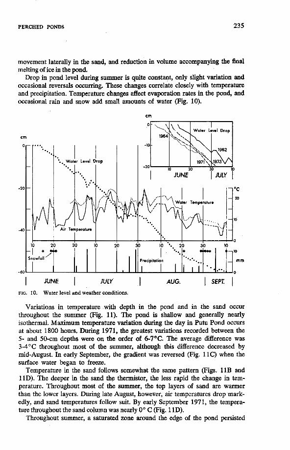
movement laterally in the sand, and reduction in volume accompanying the final melting of ice in the pond.
Drop in pond level during summer is quite constant, only slight variation and occasional reversals occurring. These changes correlate closely with temperature and precipitation. Temperature changes deet evaporation rates in the pond, and occasional rain and snow add small amounts of water (Fig. 10).
cm
0-
-
-20 -
-
-40 -
-
.,
- c IO
Snowfall
-60
I I I I
30 10 20
cm
I JUNE
I JUNE I JULY I AUG.
FIG. 10. Water level and weather conditions.
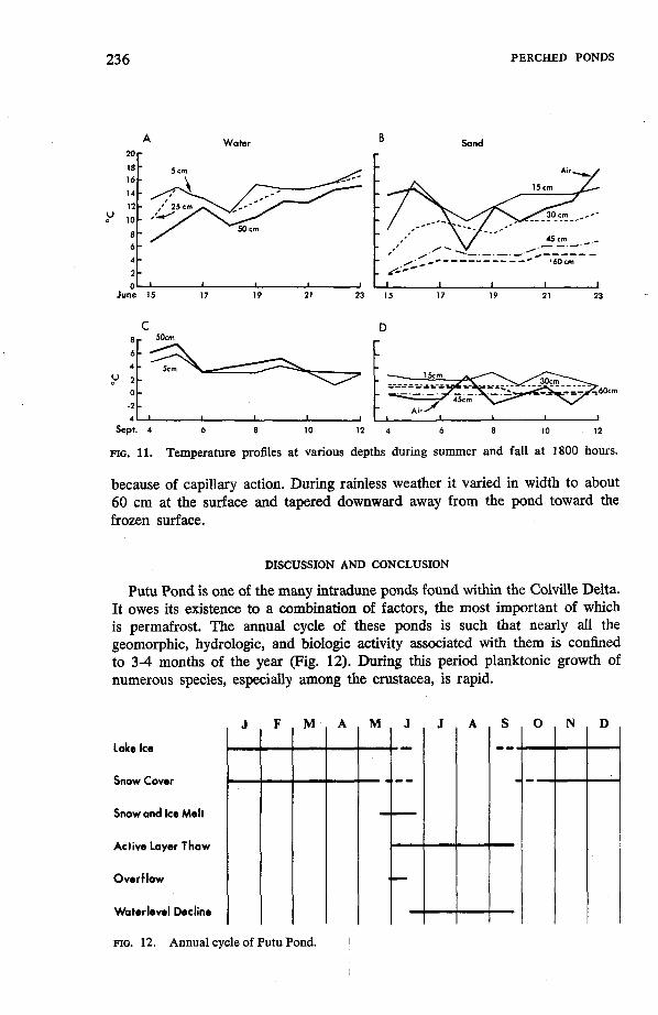
Variations in temperature with depth in the pond and in the sand occur throughout the summer (Fig. 11). The pond is shallow and generally nearly isothermal. Maximum temperature variation during the day in Putu Pond occurs at about 1800 hours. During 1971, the greatest variations recorded between the 5- and 50-cm depths were on the order of 6-7OC. The average difference was 3-4OC throughout most of the summer, although this difference decreased by mid-August. In early September, the gradient was reversed (Fig. 11C) when the surface water began to freeze.
Temperature in the sand follows somewhat the same pattern (Figs. 11B and 1 1D). The deeper in the sand the thermistor, the less rapid the change in tem- perature. Throughout most of the summer, the top layers of sand are warmer than the lower layers. During late August, however, air temperatures drop mark- edly, and sand temperatures follow suit. By early September 1971, the tempera- ture throughout the sand column was nearly 0" C (Fig. 11D).
Throughout summer, a saturated zone around the edge of the pond persisted
236
U
A Water
:t O L ' I I I I
June 15 17 19 21 23
PERCHED PONDS
L I I 1 I 1 17 19 21 15 23
C D
U
0 -2
Sept. 4 6 8 10 12 4 6 8 10 12
FIG. 11. Temperature profiles at various depths during summer and fall at 1800 hours.
because of capillary action. During rainless weather it varied in width to about 60 cm at the surface and tapered downward away from the pond toward the frozen surface.
DISCUSSION AND CONCLUSION
Putu Pond is one of the many intradune ponds found within the Colville Delta. It owes its existence to a combination of factors, the most important of which is permafrost. The annual cycle of these ponds is such that nearly all the geomorphic, hydrologic, and biologic activity associated with them is confined to 3-4 months of the year (Fig. 12). During this period planktonic growth of numerous species, especially among the crustacea, is rapid.
Lake Ice
Snow Cover
Snow and Ice Melt
Active Layer Thaw
Overflow
Waterlevel Decline
FIG. 12. Annual cycle of Putu Pond.

PERCHED PONDS 237
Although Putu Pond has been considered herein as a perennial pond, it is not a permanent feature of the landscape. Indeed, on almost any geomorphic time scale, it and all other intradune ponds are short-lived. In the case of Putu Pond there are at least two major processes leadiig to its extinction. The first process is the headward erosion of the overfiow drainage channel
(Fig. 2). This channel, which has a vertical drop of more than 1.0 m at its head, is eroding at a rate of about 0.7 m per year. Most of this retreat occurs. during the two weeks of overflow at the time of snowmelt.
The second process is the gradual filling of the pond by windblown sand. The nearly-complete vegetation cover over all but the steepest part of the basin, and the presence of water in the basin bottom, ensure that nearly all the sand that enters the basin is trapped. The unvegetated portions are on the steep southerly- facing portion of the basin (Fig. 4). In such a position the bare sand is protected from the prevailing (i.e., northeasterly) winds. The amount of sand added to the basin depends mainly on the strentgh and persistence of the wind during the snow-free period; During a series of windstorms in 1967 a 15-rn2 area at the eastern end of the basin was covered by a sand deposit that ranged up to 20 cm in thickness. The dunes northeast of Putu Pond are generally bare and are therefore excellent source areas (Fig. 2).
Although the two processes noted above are the major factors in reducing the longevity of the pond, the biota of the area are also significant. Upon dying, pond vegetation (Fig. 4) is added to the bottom. As the pond decreases in depth, water vegetation encroaches centreward. Squirrels are also effective agents because they bring to the surface much sand which moves downslope toward, and into, the pond.
Calculations based on data summarized in this paper show that Putu Pond will be drained before the year 2000.
ACKNOWLEDGEMENTS
We thank R. Hamilton, W. Lampa, L. McKenzie, D. Nemeth, J. Peake, and C. Wax for field assistance. This study was supported by the Arctic Program and Geography Programs, US. Office of Naval Research with the Coastal Studies Institute, Louisiana State University. Logistic support that made the fieldwork possible was provided by the Naval Arctic Research Laboratory, Barrow, Alaska.
REFERENCES
BLACK, R. F. 1951. Eolian deposits of Alaska. Arctic, 4 (2): 89-1 11. BREWER, M. c. 1958. The thermal regime of an arctic Lake. E@S: Transactions, American
Geophysical Union, 39 (2): 278-84. CARSON, E. C. and HUSSEY, K. M. 1959. The multiple-working hypothesis as applied to
Alaska's oriented lakes. Zowa Academy of Science, Proceedings, 6 6 336-45. COALDRAKE, J. E. 1960. The coastal sand dunes of southern Queensland. Royd Society of
Queensland, Proceedings, 72(7):101-21. HOBBIE, J. E. 1974. Arctic limnology: a review. In: Reed, J. C. and Sater, J. E. (eds.),
The Coast and Shelf of the Beaufort Sea; Proceedings of the Arctic Institute of North America Symposium on Beaufort Sea Coast and Shelf Research, Arliion, Va.: Arctic Institute of North America.

23 8 PERCHED PONDS
HOPKINS, D. M. 1949. Thaw lakes and thaw sinks in the Imuruk Lake area, Seward Peninsula,
HUSSEY, K. M. and MICHELSON, R. W. 1966. Tundra relief features near Point Barrow,
JENNINGS, J. N. 1957. Coastal dune lakes as exemplified from Kind Island. Geographical
Alaska. Journal of Geology, 57:119-31.
Alaska. Arctic, 19 (2): 162-84.
Journal, 12353-70.
in permafrost. Temperature -Its Measurement and Control in Science and Industry; Proceedings, 4th Symposium on Temperature. New York Reinhold Publishing Corporation,
MOTTS, w. s. 1965. Hydrologic types of playas and closed valleys and some relations in hydrology to playa geology. Geology, Mineralogy, and Hydrology of U.S. Playas. Bedford, Mass.: US. Air Force Cambridge Research Laboratories (Environmental Research Paper 96), pp. 75-103.
MULLER, s. w. 1947. Permafrost or Perennially Frozen Ground and Related Engineering Problems. Ann Arbor, Mich.: Edwards.
RICKER, K. 1962. Polar ice-dammed lakes. Canadian Alpine Journal, 45: 149-51. RITCHIE, w. and WALKER, H. J. 1974. Riverbank forms of the Colville River delta. In: Reed,
J. C. and Sakr, J. E. (eds.), The Coast and Shelf of the Beaufort Sea; Proceedings of the Arctic Znstitute of North America Symposium on Beaufort Sea Coast and Shelf Research, Arlington, Va.: Arctic Institute of North America, pp. 545-62.
SELLMANN, P. V., BROWN, J., LEWELLEN, R. I., MCKIM, H. and MERRY, C. 1975. The classifica- tion and geomorphic implications of thaw lakes on the arctic Coastal Plain, Alaska. Hanover, New Hampshire: U.S. Army Cold Regions Research and Engineering Laboratory (in print).
STEARNS, H. L., BRYAN, L. L. and CRONDEL, L. 1939. Geology and water resources of the Mud Lake region, Idaho, including the island park area. US., Geological Survey, Water Supply Paper no. 818.
SWANSON, v. E. and PALACAS, J. G. 1965. Humate in coastal sands of northwest Florida. U.S., Geological Survey, Bulletin no. 1214-B.
VEATCH, J. 0. and HUMPHREYS, C. R. 1964. Lake Terminology. East Lansing, Mich.: Michigan State University, Department of Resource Development, Agricultural Experiment Station (Water Bulletin no. 14).
ground water resources of Long Island, New York. U.S., Geological Survey, Professional Paper no. 44.
Coastal Studies Znstitute Bulletin, 1:7-14. 1974. The Colville River and the Beaufort Sea: some interactions. In: Reed,
J. C. and Sater, J. E. (eds.), The Coast and Shelf of the Beaufort Sea; Proceedings of the Arctic Institute of North America Symposium on Beaufort Sea Coast and Shelf Research, Arlington, Va.: Arctic Institute of North America, pp. 513-40.
WILLIAMS, J. R. 1970. Groundwater in the permafrost regions of Alaska. U.S., Geological Survey, Professional Paper no. 696.
LACHENBRUCH, A. H., BREWER, M. C., GREENE, G. W. and MARSHALL, B. V. 1962. Temperatures
pp. 791-803.
VEUTCH, A. C., SLICHTER, C. S., BOWMAN, I., CROSBY, W. D. and HORTON, R. E. 1906. Under-
WALKER, H. J. 1967. Riverbank dunes in the Colville Delta. Louisiana State University,