Embed Size (px)
Citation preview

CPAT Report No 1163
Pen-y-gaer Roman Vicus, Cwmdu, Powys: Excavation and survey 2005-2012
THE CLWYD-POWYS ARCHAEOLOGICAL TRUST

CPAT Report No 1163
Pen-y-gaer Roman Vicus, Cwmdu, Powys: Excavation and survey 2005-2012
N W Jones and R Hankinson August 2012
Report for Cadw
The Clwyd-Powys Archaeological Trust 7a Church Street, Welshpool, Powys, SY21 7DL
tel (01938) 553670, fax (01938) 552179 © CPAT 2012

CPAT Report No. 1163 Pen-y-gaer Roman Vicus, Cwmdu: Excavation and survey 2005-2012
CONTENTS
1 INTRODUCTION AND BACKGROUND 2 EXCAVATION 3 FINDS 4 CONCLUSIONS 5 ACKNOWLEDGEMENTS
6 REFERENCES
1

CPAT Report No. 1163 Pen-y-gaer Roman Vicus, Cwmdu: Excavation and survey 2005-2012
1 INTRODUCTION AND BACKGROUND 1.1 Pen-y-gaer Roman fort (Fig. 1; SO 168 219) stands on a small knoll about 2km to the east of a
pass between Buckland Hill and the Cefn Moel ridge, now occupied by the village of Bwlch in what was Brecknock but is now southern Powys. It lies approximately half way along the Roman route linking the larger forts at Brecon and Abergavenny.
Fig.1: Location of the fort, together with the excavations and areas of geophysical survey
1.2 The presence of a Roman fort here was probably first noted by Thomas Payne who directed and accompanied the Wiltshire antiquary, Sir Richard Colt Hoare, along with Richard Fenton, to the site in 1803 (Payne 1831; Thompson 1983, 238). The fort was subsequently referenced to by Colt Hoare’s local contemporary and fellow traveller, the Brecknock antiquary Theophilus Jones (1805-9, 499). Colt Hoare recognised the foundations of buildings in the surrounding fields and noted the occurrence of large quantities of brick and tile.
2

CPAT Report No. 1163 Pen-y-gaer Roman Vicus, Cwmdu: Excavation and survey 2005-2012
1.3 Payne’s interest in Pen-y-gaer may have been the result of the discovery in 1801 of a ‘kind of vault’ just outside the centre of the east defences, which he considered to have been an ossuary as human bones were found within it. Payne noted three coins from the site: Marcus Aurelius as Caesar (AD 145-61); Constantine I (c. AD 307 or 308); and Constantine II as Caesar (AD 332-3) (RCAHMW 1986, 147). A collection of Payne’s manuscripts (Powys Archive B/D/BM/A104) contains a survey of the fort conducted in 1803 which depicts the outline of the ‘Roman camp’ in an area now known to lie within the vicus, along with two sections of Roman road which were removed during the 1770s (Fig. 1). A version of the survey was published by Theophilus Jones, although it is the original, in Payne’s manuscripts, which is the more informative.
1.4 The authenticity of the fort was confirmed by excavations in 1966 (Jarrett 1969, 108-110)
which apparently revealed three phases of occupation dating from 80-130 AD. The writer considered that the abandonment of the fort occurred in the reign of Hadrian, although the results of the later work recorded below imply occupation from both slightly earlier and later periods (Burnham and Davies 2010, 276).
1.5 In more recent years several small-scale investigations and observations have been made within
the fort. In June 1987 during a visit by the Cardiff Archaeological Society it was noted that a long trench had been excavated through the fort, possibly for drainage, and subsequently backfilled. Investigation of the spoil identified a range of pottery, including the first Severn Valley ware to be recognised within the fort and a Central Gaulish samian bowl of form 37, dated AD 125-150 (Cox and Webster 1987). In 1995 an evaluation was conducted by the Dyfed Archaeological Trust prior to the construction of an extension to the house at Pen-y-gaer. Probable Roman features were identified at a depth of around 0.4m, including a mortar floor and a pit (Williams and Ludlow 1995). Finally, an evaluation was undertaken by Monmouth Archaeology in 2001 prior to the extension of Greenfield Farm, which revealed traces of timber buildings and a produced pottery assemblage (Clarke et al. 2001). The only other relevant work involved excavations carried out by CPAT in 1997 on the potential site of the bath-house, some 200m to the west-north-west of the fort, although the results of this work were inconclusive (Jones 1997).
1.6 A number of coins and other objects are recorded from the fort and its environs as a result of
metal detector finds reported through the Portable Antiquities Scheme (PAS): 1) Cast copper alloy miniature-terret, probably dating from the 1st century BC to the 1st
century AD. 2) Roman cast copper alloy military buckle, probably of mid 2nd to 3rd century AD date. 3) Denarius of Vespasian inscribed TRI-POT and depicting Vesta, dated to c. AD 70-2 4) Plated counterfeit denarius of Domitian inscribed ?TR?XIII, dated to AD 93 or later. 5) Domitian as. 6) Trajanic dupondius inscribed FELICITAS SENATVS POPVLVSQVE ROMANVS. 7) Hadrianic dupondius inscribed PONT MAX TR [POT COS II] SC //FORT RED.
1.7 Renewed interest in the site came with the completion by CPAT in 2006 of a programme of
geophysical survey in the area surrounding the fort (see Fig. 1), funded by Cadw. This identified an area in the field to the south of the fort which appeared to have significant archaeological potential (Hankinson and Silvester 2006), and included a possible building (Fig. 2; SO 16849 21796). However, the part of the field between this and the lane to the east was not thought at the time to present much potential, although recent reprocessing of the data suggested otherwise.
1.8 An excavation in 2007, again funded by Cadw, was fairly limited in nature, comprising a single
trench positioned to investigate the building identified by the geophysical survey (Fig. 3). The results confirmed the existence of stone walls associated with one or more buildings, together with a spread of roofing tile from a possible lean-to structure. A spread of smithing waste demonstrated industrial activity in this area (Hankinson 2007).
3

CPAT Report No. 1163 Pen-y-gaer Roman Vicus, Cwmdu: Excavation and survey 2005-2012
1.9 This report presents a summary of a second phase of excavation, conducted in May 2011, which investigated further the buildings identified in 2007. This involved the partial re-excavation of the original excavation, together with a broadening of the excavation area to the south (Hankinson and Jones 2011). It was followed by further work in June 2012 which extended the 2011 trench and examined two additional trenches adjacent to the lane that edges the east side of the field.
Fig. 2: Geophysics results from the field to the south of the fort with the location of the excavations of 2007, 2011 and 2012 superimposed
4

CPAT Report No. 1163 Pen-y-gaer Roman Vicus, Cwmdu: Excavation and survey 2005-2012
1.10 The 2011 and 2012 excavations were undertaken by volunteers from the Llangynidr Local History Society (LLHS), under the direction of CPAT, with additional assistance in 2012 by volunteers from Brecon U3A and the Monmouthshire Antiquarian Association. Grant aid for both the 2011 and 2012 excavations was provided by Cadw, with additional funding in 2011 by The Beacons Trust, arranged by Mrs Jan Bailey of LLHS. Both excavations offered an opportunity for the volunteers to enhance their excavation experience and to increase their knowledge of the archaeology of their Usk Valley locality.
Fig. 3: The 2007 excavation in Area A, viewed from the east. Photo CPAT 2481-0032 2 EXCAVATION 2.1 The following discussion amalgamates the results from three seasons of excavation undertaken
in the western of the two fields south of the fort, in 2007, 2011 and 2012, investigating three areas (see Fig. 00). In each season of excavation the topsoil was carefully removed by machine, with all subsequent excavation and cleaning carried out by hand. The excavations were generally restricted to the identification and recording of the uppermost Roman deposits, with only minimal investigation of the features that were exposed. The numbers in brackets in the following text refer to individual contexts recorded in the site archives for the three excavations, which have been combined into a single series to prevent confusion. The excavations revealed a sequence of buildings and other structures which are dealt with individually below.
5

CPAT Report No. 1163 Pen-y-gaer Roman Vicus, Cwmdu: Excavation and survey 2005-2012
Fig. 4: Composite plan of the 2007, 2011 and 2012 excavations in Area A
6

CPAT Report No. 1163 Pen-y-gaer Roman Vicus, Cwmdu: Excavation and survey 2005-2012
Area A 2.2 The 2007 excavation (Fig. 3) was aligned approximately east/west and measured 16.3m by
2.9m; it was overlapped on its south side by the 2011 excavation (Fig. 5) which examined an area of 17.9m east/west by 5.0m north/south, about 0.9m of their width being common to both areas. The east end of the 2011 excavation extended about 3m beyond that of 2007 and had a small extension at its south-east corner. In 2012 a single 33m-long trench, aligned north/south, was positioned across the area of the previous excavations (Fig. 6).
Fig. 5: The 2011 excavation in Area A, viewed from the east. Photo CPAT 3295-0193
2.3 It seems likely that the earliest building (58) was found at the western end of the 2007 and 2011 trenches and was represented by two parallel walls (25 and 45), respectively 1.1m and 0.8m in width. It was aligned roughly north/south and 5.8m apart, with both ends beyond the limits of excavation, demonstrating it was at least 7.0m long. The walls were of similar, un-mortared construction, utilising large boulders with small packing stones and silt in between. Only the basal courses of the walls survived and both were incomplete, having been partly robbed as well as having some stones displaced by the plough. The presence of a further structure to the west of the building is suggested by a possible robber trench (48), seen in 2011, running out to the west at right angles from wall (25), which may indicate the position of a further wall. In addition, there was the base of a relatively insubstantial wall (29) composed of a single alignment of stones, only seen only in 2007 (Fig. 8).
7
CPAT Report No. 1163 Pen-y-gaer Roman Vicus, Cwmdu: Excavation and survey 2005-2012
Fig. 6: The 2012 excavation in Area A, viewed from the north. Photo CPAT 3477-0061
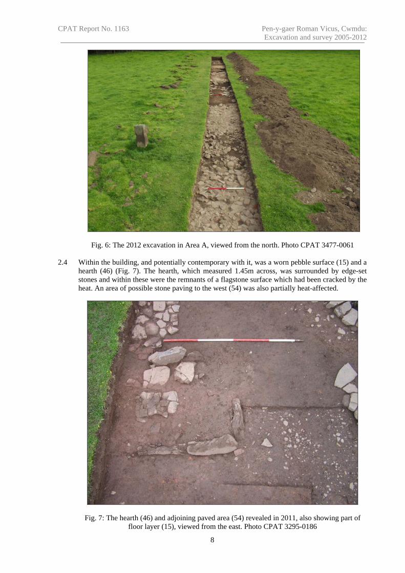
2.4 Within the building, and potentially contemporary with it, was a worn pebble surface (15) and a hearth (46) (Fig. 7). The hearth, which measured 1.45m across, was surrounded by edge-set stones and within these were the remnants of a flagstone surface which had been cracked by the heat. An area of possible stone paving to the west (54) was also partially heat-affected.
Fig. 7: The hearth (46) and adjoining paved area (54) revealed in 2011, also showing part of floor layer (15), viewed from the east. Photo CPAT 3295-0186
8

CPAT Report No. 1163 Pen-y-gaer Roman Vicus, Cwmdu: Excavation and survey 2005-2012
Fig.
8 D
etai
led
plan
of t
he 2
007
and
2011
exc
avat
ions
in A
rea
A
9

CPAT Report No. 1163 Pen-y-gaer Roman Vicus, Cwmdu: Excavation and survey 2005-2012
2.5 Also within the building, although without any stratigraphic relationship to confirm an association, was a small, stone-lined well (51) (Fig. 9). This was sub-circular in plan and measured up to 1.0m in diameter internally. Only the upper 0.5m of its voided rubble fill (52) was removed, and this was sufficient to confirm the nature of the feature. A spread of roof tiles (21) lay immediately to the north of the well and perhaps represented a lean-to structure or covered walkway placed on the inside (east) face of wall (25), implying it post-dated the occupation of the building. An area of stone (13) to the east, from which the bottom half of a rotary quern was recovered in 2007, may indicate the position of a rubble-filled pit within the area of the building, but its relationship was not determined.
Fig. 9: The well (51) and area of roof tile (21) on the east side of wall (25) exposed in 2011, viewed from the north. Photo CPAT 3295-0138
2.6 A second building (59) was identified less than 0.5m to the east of wall (45) of building (58), which respected both the position and alignment of the earlier building to such a degree that the two may have been standing at the same time. This had been built of higher quality masonry, using sandstone slabs to construct walls that were faced on either side, with occasional rubble infill where necessary. Again the walls were not mortared.
2.7 The layout was interesting in that it seemed to consist of a linear alignment of wall (5), around
0.7m thick, of which three courses survived to a height of around 0.4m above the stepped foundation, which itself extended for at least a further 0.2m in depth. Tied into this wall on its western side was a further wall (34) of similar construction that appeared with wall (81) to define a room measuring 3.5m east/west by almost 3.0m north/south. Although another wall (84) lay a further 4.7m to the south, so it is possible that the room formed part of a longer range measuring about 7.7m north/south (Fig. 10). A partially pebble-covered surface (83) lay immediately to the south of wall (81) and may have defined a doorway into the room. Around 3.6m to the north of wall (34) were the remains of another wall (10), 2.0m long (east/west). This did not appear to be tied in to wall (5) and may be a later addition. It is possible that
10

CPAT Report No. 1163 Pen-y-gaer Roman Vicus, Cwmdu: Excavation and survey 2005-2012
building (59) was in part open-fronted, with a combination of enclosed rooms and an open-sided yard facing west and partitioned by wall (10); its northern end is unlikely to have continued beyond a metalled surface or road (88, see below), thereby giving a maximum possible north/south dimension of 17.8m.
Fig. 10: The room in building (59) defined by wall (34), viewed from the west in 2011. Photo CPAT 3295-0121
2.8 The room contained a reasonable quantity of coal in its fill (35), and this was paralleled to the
north, where a deposit of industrial waste (11), comprising smithing slag, fragments of hearth base, hammer-scale and anthracite/coal was revealed beneath a significant quantity of rubble (36) from the demolition or collapse of the building. The nature of the industrial deposit indicates that somewhere in the locality there was a Roman smithy which used coal as its source of fuel. Wall (10) appeared to have been constructed on top of the waste material, confirming its later origin. Little roofing material was encountered, although this might be because the majority of the rubble was left in situ and not examined.
2.9 The industrial waste did not extend into the earlier building (58), to the west of wall (45),
although some of the material may have been spread across the line of the wall when stones were removed from it at a later date. Indeed, it seems likely that both buildings (58 and 59) were still standing when the smithy was in operation, the waste material being sealed beneath rubble from the collapse of the eastern structure (59).
2.10 A drain (38) lay immediately to the east of wall (5) and this appears to be the same as a feature
revealed by the geophysical survey, extending for at least 40m in a north/south direction. Its south end was no doubt at the stream, although the course of the Ewyn Brook in the Roman period has not been establish with any accuracy. Only limited excavations were undertaken to investigate the drain (Fig. 11), which indicated that it was at least 0.55m deep, with the lower fill including smithing waste (68), similar to the deposit (11) identified on the western side of
11

CPAT Report No. 1163 Pen-y-gaer Roman Vicus, Cwmdu: Excavation and survey 2005-2012
the wall. Interestingly, the external (east) face of wall (5) had been reinforced throughout by the later addition of a line of edge-set stones (65), which included a single Roman tile. The wall also incorporated a small culvert (56), which fed into the drain from the area to the north of wall (34) and this may have been partially responsible for the smithing waste in the drain fill.
Fig. 11: The drain (38) exposed in 2011, viewed from the north with wall (05) to the west and wall (37) to the east, showing the area of collapse. Photo CPAT 3295-0102
2.11 Over time the drain had evidently fallen out of use. It became completely infilled, and then its
eastern side was sealed beneath a masonry wall (37) which ran parallel to wall (5) and was of similar construction, perhaps representing the western side of a further building (60). Within the area excavated in 2011 the northern part of this wall had subsided into the drain, leading to its collapse (see Fig. 11).
2.12 To the east of the drain, in the south-east corner of the excavation, were the remains of what
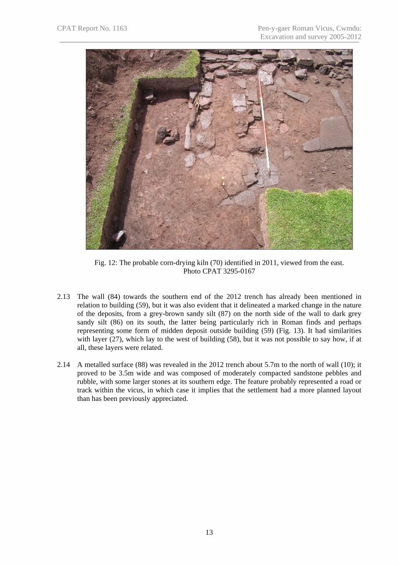
appears to have been a small corn-drying kiln (70). The flue consisted of two parallel walls with a surviving length of 1.8m and set 0.4m apart, aligned east/west. At the eastern end there was a floor formed by stone slabs, some of which were heavily fire-cracked, suggesting this was the stokehole (Fig. 12). Only the very base of the structure survived, although a post-hole (71) immediately to the south may have been associated with some form of wooden superstructure. It may be significant that one of the upper fills (66) of the drain (38) contained burnt material which could have originated from the kiln, and it seems almost certain that the western end of the kiln was truncated by the drain.
12
CPAT Report No. 1163 Pen-y-gaer Roman Vicus, Cwmdu: Excavation and survey 2005-2012
Fig. 12: The probable corn-drying kiln (70) identified in 2011, viewed from the east. Photo CPAT 3295-0167
2.13 The wall (84) towards the southern end of the 2012 trench has already been mentioned in relation to building (59), but it was also evident that it delineated a marked change in the nature of the deposits, from a grey-brown sandy silt (87) on the north side of the wall to dark grey sandy silt (86) on its south, the latter being particularly rich in Roman finds and perhaps representing some form of midden deposit outside building (59) (Fig. 13). It had similarities with layer (27), which lay to the west of building (58), but it was not possible to say how, if at all, these layers were related.
2.14 A metalled surface (88) was revealed in the 2012 trench about 5.7m to the north of wall (10); it
proved to be 3.5m wide and was composed of moderately compacted sandstone pebbles and rubble, with some larger stones at its southern edge. The feature probably represented a road or track within the vicus, in which case it implies that the settlement had a more planned layout than has been previously appreciated.
13

CPAT Report No. 1163 Pen-y-gaer Roman Vicus, Cwmdu: Excavation and survey 2005-2012
Fig. 13: The possible Roman midden deposit to the south of wall (84), from the south. Photo CPAT 3477-0026
Fig. 14: The possible road (88) within the vicus, from the east. Photo CPAT 3477-0026
14

CPAT Report No. 1163 Pen-y-gaer Roman Vicus, Cwmdu: Excavation and survey 2005-2012
Fig.
15
Plan
and
sect
ion
of A
rea
B
15

CPAT Report No. 1163 Pen-y-gaer Roman Vicus, Cwmdu: Excavation and survey 2005-2012
Area B (Fig. 15) 2.15 A trench, measuring 22m by 1.6m to 2.1m, was excavated in 2012 to investigate the potential
for development of the vicus along the road leading south from the fort, which is presumed to underly the existing lane. The presence of a slight earthwork terrace within the field, parallel to the lane, had been seen as potentially being part of the Roman road, although the excavation demonstrated that this was simply a spread of rubble from the roadside boundary wall. Unlike Area A, the overburden was deep, with up to 0.75m of material being removed by machine onto the surface of in-situ Roman deposits. At the eastern end of the trench machining included the removal of a layer of rubble (201) which was assumed to have been derived from a boundary wall, although possibly not that which survives today.
Fig. 16 Building 206 viewed from the south. Photo CPAT 3478-0066 2.16 A deposit of dark brown, clay silt (209, 210, 246) containing Roman pottery and other finds
was observed along the majority of the trench and was in part removed by the machine. Towards the western end of the trench this partly overlay the remains of a building (206) which, as in Area A, had been founded on stone sleeper walls (207 and 208) and is likely to have been of timber-frame construction, probably with a tiled roof (Fig. 16). Several courses of dry-stone, or perhaps clay-bonded walling survived, up to a height of around 0.4m. Within the confines of the trench it was not possible to determine with any certainty the dimensions of the building. It is possible that wall 207, aligned west to east, supported an outside wall, although since its northern side lay beyond the excavation this is only speculative. Similarly, wall 208, which formed the western end of the building, extended beyond the limits of excavation to the south. From the surviving remains of wall 207 it was clear, however, that the building was a minimum of 6m in length and extended at least as far as a deposit of dark brown, firm, sandy silt (227), which included the position of a stone displaced by the machine and may represent the position of a robbed wall.
16

CPAT Report No. 1163 Pen-y-gaer Roman Vicus, Cwmdu: Excavation and survey 2005-2012
Fig. 17 Oven 215 viewed from the north. Photo CPAT 3478-0068 2.17 Limited investigations within the building identified a small domestic oven (215) constructed in
stone and reused roofing tile (Fig. 17). Internally, the oven was around 0.25m in diameter and had a stokehole (218) at the western end, spanned by a stone lintel. A series of deposits were exposed between the oven and wall 208 following the removal of deposit 209, which post-dated the building. Some of these deposits, particularly 224, 225 and 226, may have been floor surfaces, perhaps reflecting areas of patching, while others, such as 221, 249 and 250 had the appearance of pits.
2.18 A series of deposits exposed in the base of the trench to the east of 227 may have been floor
layers which also lay within a building and included a large, fractured stone slab (205), overlying a deposit (229) containing roofing tile that may have lain within a pit. An area of in-situ burning (204) was also noted, although in section this clearly post-dated the Roman activity. The possible floor layers continued eastwards as far as a group of large boulders (203) surrounded by pink clay (231), which may be the remains of a wall. It was not possible to demonstrate that this was part of the same structure as walls 207 and 208, although if so this would give a length of around 13m for the building as a whole.
2.19 To the west of the building there was some evidence to suggest earlier phases of building,
including two sections of possible remnant walling (237 and 238). A general spread of stony material (252) and in particular a pebble surface (239) suggest that this area had formed by a yard. A concentration of stones (235), a number of which were on edge or tipping, suggests the presence of a large pit.
17

CPAT Report No. 1163 Pen-y-gaer Roman Vicus, Cwmdu: Excavation and survey 2005-2012
Fig. 18 Area B viewed from the west with
building 206 in the foreground. Photo CPAT 3478-0063
Fig. 19 Area B viewed from the east with possible
wall 203 beyond the scale. Photo CPAT 3478-0062
Area C (Fig. 20)
2.20 Area C, like Area B, was positioned to examine the potential for roadside occupation within the vicus. The trench, which measured 15.3m by 1.5m, was aligned west to east, and up to 0.6m of overburden was removed with a machine onto the surface of in situ Roman deposits. As in Area B a deposit of dark brown, sandy silt (304), up to 0.25m thick, was exposed containing Roman finds but post-dated any Roman activity.
2.21 Within this area, however, there was no obvious indication of a building, although the nature of
the deposits identified in the base of the trench was strongly suggestive of occupation, perhaps including floor layers. Two, or perhaps three, post-holes (308, 310 and 318) were identified, although it was not possible to determine whether they were associated.
2.22 A substantial area of stone rubble (307) at the eastern end of the trench provided hints of some
structure, although limited investigation failed to clarify the situation.
18

CPAT Report No. 1163 Pen-y-gaer Roman Vicus, Cwmdu: Excavation and survey 2005-2012
Fig.
20
Plan
of t
he 2
012
exca
vatio
ns in
Are
a C
19

CPAT Report No. 1163 Pen-y-gaer Roman Vicus, Cwmdu: Excavation and survey 2005-2012
Fig. 21 Area C viewed from the west. Photo
CPAT 3478-0081
Fig. 22 Area C viewed from the east with stone deposit 307 in the foreground. Photo
CPAT 3478-0087
3 THE FINDS
3.1 At the time of writing no detailed studies have been undertaken on any of the finds from the
three seasons of excavation. The metalwork is currently awaiting x-ray and assessment at the Department of History, Archaeology and Religion at Cardiff University. The excavations produced a reasonable assemblage of pottery, together with some glass, and included a number of diagnostic sherds which will assist with the overall dating of occupation in the areas investigated.
4 CONCLUSIONS 4.1 The three seasons of excavation to the south of Pen-y-gaer Roman fort have added significantly
to our understanding of extra-mural activity, and have confirmed the significance of a number of features which were initially identified through geophysical survey. Evidence from the excavations, together with antiquarian sources, indicates that a civilian settlement, or vicus, developed to the south of the fort, lying to the west and east of what is believed to be the via principalis, which was later adopted by a modern lane.
4.2 To the west of the road at least it is now clear that the area was occupied by a complex of
buildings which may have been laid out with respect to the Roman road, along with one or more side roads. Although the nature and extent of the occupation remains uncertain, it is clear that there was significant industrial activity, in the form of iron smithing, and it seems likely that the buildings in this area housed a variety of small-scale industries.
4.3 All of the buildings which have been identified to date appeared to have been constructed on
stone sleeper walls, which would have supported timber-framed structures with tiled roofs.
20

CPAT Report No. 1163 Pen-y-gaer Roman Vicus, Cwmdu: Excavation and survey 2005-2012
Domestic structures have also been recorded, including a small oven, a hearth and a well. The evidence from Area A indicates the presence of at least three buildings, each of which may be associated with a different phase of activity, suggesting some longevity to the occupation. It is hoped that the results from post-excavation analysis of the pottery will provide an indication of the period during which the vicus was occupied.
4.4 Despite the close proximity of some of the surviving remains to the present ground surface, the
preservation of Roman levels was generally good, although some plough scarring was evident where structures approached the surface and traces of stone robbing were also noted. The depth of the Roman deposits, however, remains to be confirmed since the approach adopted by the excavations was largely non-intrusive.
4.5 It is intended to conduct a programme of post-excavation analysis during 2013-14, leading to a
final publication in an appropriate journal. 5 ACKNOWLEDGEMENTS 5.1 The writers would like to thank the following: members of the Llangynidr Local History
Society, Monmouthshire Antiquarian Association and Brecon U3A for their assistance, interest and support during the excavations; Mr D Hingley for undertaking the metal detector surveys; and in particular the present landowner, Mr P Morris, and to the landowners at the time of the 2007 excavation, Mr and Mrs James, for their willingness to allow us to excavate.
6 REFERENCES
Burnham, B C and Davies, J L, (eds) 2010. Roman Frontiers in Wales and the Marches. Aberystwyth: RCAHMW, 276.
Clarke, S, Bray, J, Taylor, F and Milford, B, 2001. Bwlch, Greenhill Farm, Archaeology in
Wales 41, 139. Cox, M and Webster, P, 1987. Pen y Gaer, Archaeology in Wales 27, 44. Hankinson, R and Jones, N W, 2011. Pen-y-gaer Roman vicus, Cwmdu: Draft Interim Report.
CPAT Report No. 1107. Hankinson, R, and Silvester, R J, 2006. Roman Fort Environs. CPAT Report No 767. Hankinson, R, 2007. Pen-y-gaer, Bwlch, near Crickhowell, Powys: Archaeological evaluation.
CPAT Report No 904. Jones, N, 1997. Pen-y-Gaer Bath-house, Cwmdu, Archaeology in Wales 37, 78-9. Jones, T A, 1805-9. A History of the County of Brecknock. Jarrett, M G, 1969, The Roman Frontier in Wales. Cardiff: UWP. Payne, H T, 1831. Account of a Roman station near Crickhowel, in Brecknockshire,
Archaeologia Scotica 3, 91-98. RCAHMW 1986. An Investory of the Ancient Monuments in Brecknock (Brycheiniog). The
Prehistoric and Roman Monuments, Part II: Hill-forts and Roman Remains. HMSO.
21
CPAT Report No. 1163 Pen-y-gaer Roman Vicus, Cwmdu: Excavation and survey 2005-2012
Thompson, M W, 1983. The Journeys of Sir Richard Colt Hoare through Wales and England
1793-1810. Gloucester: Alan Sutton. Williams, G and Ludlow, N, 1995. Tretower, Pen-y-gaer, Archaeology in Wales 35, 50. Williams, G H, 1995. Pen-y-gaer Roman Fort, Llanfihangel Cwm-du, Brecknockshire. Dyfed
Archaeological Trust Report.
22