Embed Size (px)
Citation preview

Severe Weather Safety By: Christine Krause, Forecaster
Spring 2013
The Dryline
Inside this issue:
Severe Weather
Preparedness
2
Historic
Blizzard
3
Ping! 4
El Nino/
La Nina
5
Spring is a season characterized by warmer temperatures. In turn, people get reju-venated and ready for all the delights that warm weather affords us, especially after a long and cold winter. Springtime is also earmarked by wild swings in weather from warm and windy days, to cool evenings, to several rounds of thunderstorms. Thunderstorms are part of life in the Texas and Oklahoma Panhandles. In Amarillo, 87% of the annual rainfall is received from March through October, and almost all of this can be attributed to thunderstorms. Without this beneficial rain, the Panhan-dles would be a virtual desert.
...Severe Weather Safety continued on page 2...
February 25, 2013 Blizzard
A historic blizzard struck the Panhandles during the early morning hours of Monday, February 25 and continued through the afternoon hours. A very in-tense upper-level disturbance produced a band of heavy snow that set up over the central Panhandles from roughly Amarillo to Borger to Perryton during the early morning hours on Monday. Within this band of snow, snowfall rates ap-proached 2-3 inches per hour, thundersnow was observed, and extreme bliz-zard conditions were observed. As this band moved west to east during the morning hours, many locations from Hereford to Beaver received more than 10 inches of snow. The heavy snow and strong winds resulted in visibilities less than 50 feet at times for many of these locations. As a result, this crippled the entire area and made travel almost impossible. In fact, all roads in the Texas and Oklahoma Panhandles were closed, including Interstate 40 from the New Mexico border to the Oklahoma border and Interstate 27 from Amarillo to Lub-bock. Conditions were so severe that Texas Department of Transportation-crews were not able to work to keep the roads plowed. Rick Husband Interna-tional Airport in Amarillo was shut down for most of the day. 19 inches of snow accumulated at NWS Amarillo along with a peak wind gust of 75 mph late Monday morning. A peak wind gust of 77 mph was also recorded at the Pantex Nuclear facility. Unfortunately, many motorists were also stranded.
...For More Information and Pictures turn to page 3...

Page 2 The Dryline
Severe Weather Safety continued... By: Christine Krause, Forecaster
However, when thunderstorms do occur there are many hazards that can damage property or threaten lives. It is important that everyone be aware of these hazards and know how to protect themselves and their property.
Lightning is a part of EVERY thunderstorm and often strikes without warning. Lightning kills dozens of people
and injures hundreds more each year in the United States. Most deaths occur when people are caught outside with no shelter. It is important to remember that lightning can strike several miles away from the thunderstorm, so the best place to be is indoors. If you hear thunder, you are close enough to be struck by lightning and should seek shelter immediately!
Flooding causes more than 100 deaths each year in the United States and can occur almost anywhere. Most
flood related deaths occur in automobiles. Even if you don’t live near a river or stream, you can still be affected by flood waters. Flash flooding is an increased concern in the Texas and Oklahoma Panhandles during the sum-mer months when thunderstorms produce very heavy rainfall in a short amount of time. Drainage systems may not be able to handle all the water at once and roads and underpasses can quickly flood. If you run across water covering the road, you should turn around and find an alternate route. It only takes a foot or two of water to cause your vehicle to stall or float.
Severe Thunderstorms can produce large hail and damaging straight line winds. A severe thunderstorm is
defined as having hail one inch in diameter (the size of a quarter) or larger. (The straight line wind criterion of 58 mph or higher also defines a severe thunderstorm.) When severe thunderstorms approach, seek shelter in a sturdy building to avoid injury. Large hail can damage property and can cause injury to those caught outside. Strong straight line winds can occasionally exceed 100 mph and cause widespread damage equivalent to that of a tornado. These winds can destroy mobile homes and damage sturdy buildings.
Tornadoes are a very rare natural phenomenon associated with thunderstorms but occur in the Great Plains
region of the United States more than anywhere else in the world. In the Texas and Oklahoma Panhandles, tor-nadoes are most common in late spring and early summer. The strongest tornadoes can produce some of the strongest winds ever recorded at the Earth’s surface and completely destroy well-built structures. The best place to be during a tornado is in a basement or inside a small room inside a sturdy building and away from outside walls and windows. If caught outside with no shelter available, lie face down in a ditch or other low spot and cover your head. The first step in protecting yourself and your property is to know when a severe thunderstorm or tornado is ap-proaching. Understand the statements and warnings issued by the National Weather Service and have a reliable means of being alerted when these statements are issued. One of the best ways to make sure you know when a warning is issued is to have a NOAA All Hazards Weather Radio. These devices are inexpensive, are available at local electronic stores, and can be specially programmed to alert you when threatening weather is approaching.
WEATHER HAZARD WATCH WARNING
SEVERE
THUNDERSTORM
Conditions are favorable for the development of severe thunderstorms in
and close to the watch area.
Quarter size hail or winds greater than 58 mph is imminent or has been indicated by Doppler Radar or
reported by storm spotters.
TORNADO Conditions are favorable for the
development of tornadoes in and close to the watch area.
A tornado is imminent or has been indi-cated by Doppler Radar or reported
by storm spotters.
FLASH FLOOD or FLOOD Conditions are favorable for flash flooding Flash flooding or flooding is imminent
Page 3
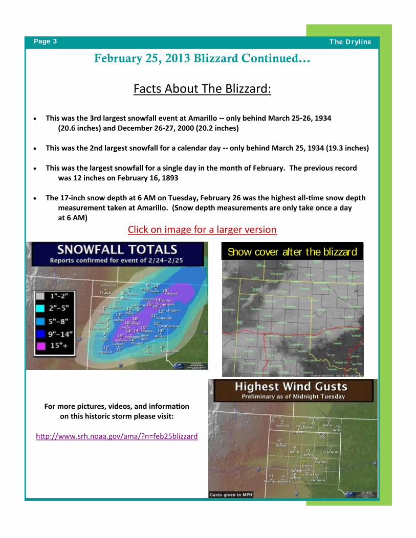
February 25, 2013 Blizzard Continued…
Facts About The Blizzard:
This was the 3rd largest snowfall event at Amarillo -- only behind March 25-26, 1934 (20.6 inches) and December 26-27, 2000 (20.2 inches) This was the 2nd largest snowfall for a calendar day -- only behind March 25, 1934 (19.3 inches)
This was the largest snowfall for a single day in the month of February. The previous record
was 12 inches on February 16, 1893 The 17-inch snow depth at 6 AM on Tuesday, February 26 was the highest all-time snow depth
measurement taken at Amarillo. (Snow depth measurements are only take once a day at 6 AM)
Click on image for a larger version
The Dryline
For more pictures, videos, and information on this historic storm please visit:
http://www.srh.noaa.gov/ama/?n=feb25blizzard
Snow cover after the blizzard
Page 4 The Dryline
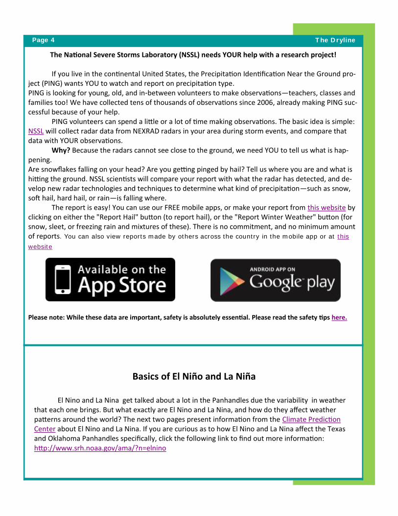
The National Severe Storms Laboratory (NSSL) needs YOUR help with a research project!
If you live in the continental United States, the Precipitation Identification Near the Ground pro-ject (PING) wants YOU to watch and report on precipitation type. PING is looking for young, old, and in-between volunteers to make observations—teachers, classes and families too! We have collected tens of thousands of observations since 2006, already making PING suc-cessful because of your help. PING volunteers can spend a little or a lot of time making observations. The basic idea is simple: NSSL will collect radar data from NEXRAD radars in your area during storm events, and compare that data with YOUR observations. Why? Because the radars cannot see close to the ground, we need YOU to tell us what is hap-pening. Are snowflakes falling on your head? Are you getting pinged by hail? Tell us where you are and what is hitting the ground. NSSL scientists will compare your report with what the radar has detected, and de-velop new radar technologies and techniques to determine what kind of precipitation—such as snow, soft hail, hard hail, or rain—is falling where. The report is easy! You can use our FREE mobile apps, or make your report from this website by clicking on either the "Report Hail" button (to report hail), or the "Report Winter Weather" button (for snow, sleet, or freezing rain and mixtures of these). There is no commitment, and no minimum amount of reports. You can also view reports made by others across the country in the mobile app or at this
website
Please note: While these data are important, safety is absolutely essential. Please read the safety tips here.
Basics of El Niño and La Niña
El Nino and La Nina get talked about a lot in the Panhandles due the variability in weather that each one brings. But what exactly are El Nino and La Nina, and how do they affect weather patterns around the world? The next two pages present information from the Climate Prediction Center about El Nino and La Nina. If you are curious as to how El Nino and La Nina affect the Texas and Oklahoma Panhandles specifically, click the following link to find out more information: http://www.srh.noaa.gov/ama/?n=elnino

March 2013
The El Niño – Southern Oscillation (ENSO) is a recurring climate pattern involving changes in the temperature of waters in the central and eastern tropical Pacific Ocean and the patterns of sea level pressure, lower- and upper-level winds, and tropical rainfall across the Pacific basin. On periods ranging from about two to seven years, the surface waters across a large swath of the tropical Pacific Ocean warm or cool by anywhere from 1°C to 3°C, compared to normal. This irregular oscillation between warm and cool patterns, referred to as the ENSO cycle, directly affects rainfall distribution in the tropics and can have a strong influence on weather across the United States and other parts of the world. El Niño and La Niña are the extreme phases of the ENSO cycle; between these two phases is a third phase called ENSO-neutral.
What is El Niño and La Niña?
Enso PhasesENSO-neutral: Normally, strong trade winds blow from the east along the equator, pushing warm water into the western Pacific Ocean.
El Niño conditions occur when abnormally warm waters accumulate in tropical latitudes of the central and eastern Pacific Ocean associated with a weakening of the low-level easterly winds. Consequently, tropical rains that usually fall over Indonesia shift eastward.
La Niña conditions occur when cooler-than-average waters accumulate in the central and eastern tropical Pacific, associated with a strengthening of the low-level easterly winds over the central tropical Pacific. Heavy rainfall occurs over Indonesia and Malaysia.
The Thermocline is a layer of water in which there is an abrupt change in temperature separating the warmer surface water from the colder deep water.
How do we tell what phase ENSO is in?NOAA’s Climate Prediction Center has determined the average monthly sea surface temperature for a particular swath [5°N-5°S, 170°W-120°W] of the tropical Pacific Ocean by averaging measurements collected there over the 30-year period 1981-2010. Scientists refer to that swath as the Niño 3.4 region. The observed difference from the average temperature in that region–whether warmer or cooler–is used to indicate the current phase of ENSO.
ENSO INDEX:Average sea surface temperature in the Niño 3.4 region is calculated for each month, and then averaged with values from the previous month and following month. This running three-month average value is compared with average sea surface temperature for the same three months during 1981 – 2010. The departure from the 30-year average of the three-month average is known as the Oceanic Niño Index or ONI.
• El Niño is characterized by a positive ONI greater than or equal to +0.5°C.
• La Niña is characterized by a negative ONI less than or equal to -0.5°C.
• Whenever the ONI is between +0.5 and -0.5, conditions are referred to as ENSO-neutral.
Source: Climate.gov
Source: NOAA/CPC

REAL-TIME MONITORINGOceanic and atmospheric conditions are updated weekly on the Climate Prediction Center (CPC) webpage: www.cpc.noaa.gov
Forecasts for the evolution of El Niño/La Niña are updated monthly in the Forecast Forum section of CPC’s Climate Diagnostics Bulletin (www.cpc.ncep.noaa.gov/products/CDB)
A monthly ENSO Diagnostics Discussion is also available on the CPC webpage. To receive an e-mail notification when the monthly ENSO Diagnostic Discussions are released, send an e-mail message to: [email protected]
ENSO GLOBAL IMPACTSEl Niño La Niña
Impacts in the United States During winterEl Niño episodes feature an equatorward-shifted, stronger-than-normal jet stream and wetter-than-average conditions across the southern part of the United States, and less storminess and milder-than-average conditions across the North.
La Niña episodes feature a wave-like jet stream flow over the United States and Canada, with colder and stormier than average conditions across the North, and warmer and less stormy conditions across the South.

weather.gov/ama
The Dryline............1900 English Road, Amarillo, TX 79108
Call us: 806.335.1121 E-mail us: [email protected]
Got a question for the Dryline editors? E-mail us at: [email protected]
• José Garcia—Publisher and Meteorologist-In-Charge • Andrew Moulton—Editor-in-Chief • Christine Krause—Editor David Wilburn—Editor • Nicholas Fenner—Editor Krissy Scotten—Warning Coordination Meteorologist Todd Lindley—Science and Operations Officer
Jose Garcia, John Harris, Steve Kersh, and Dave Oliver talk at the 2013 Severe Weather Workshop. They took questions from the audience and gave insight into what attracted
each of them to the field of meteorology.