Embed Size (px)
Citation preview
PART III Conclusions and Recommendations
Chapter1 Conclusion
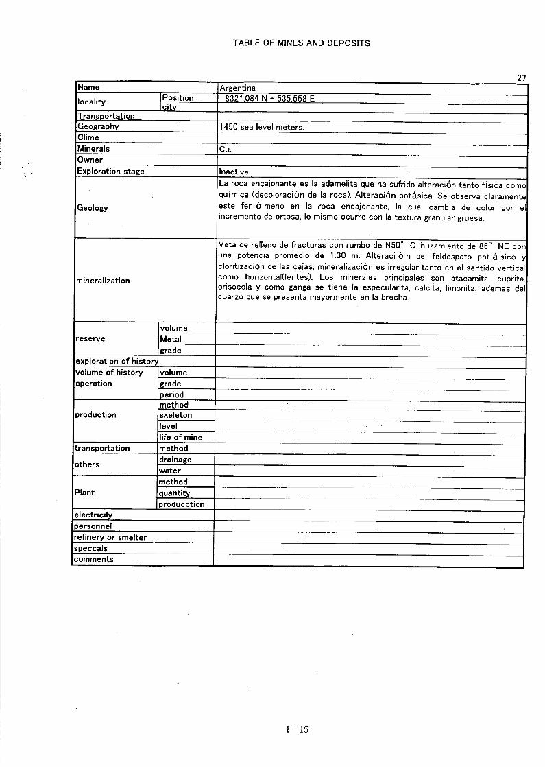
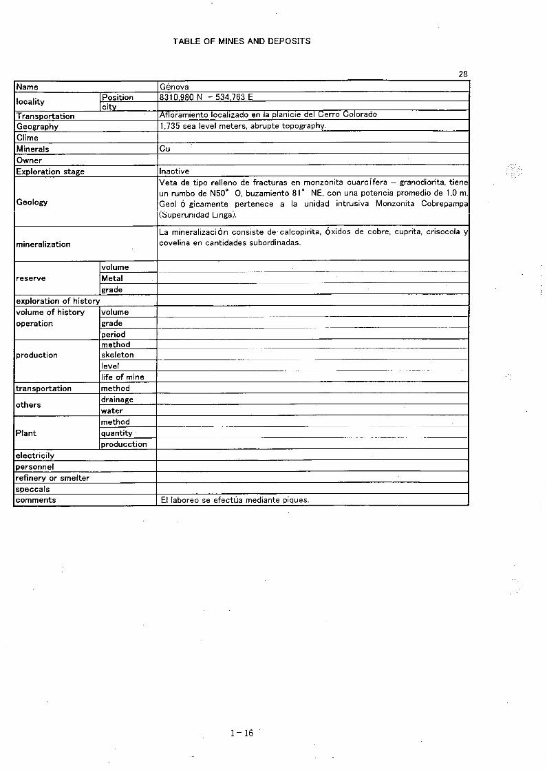
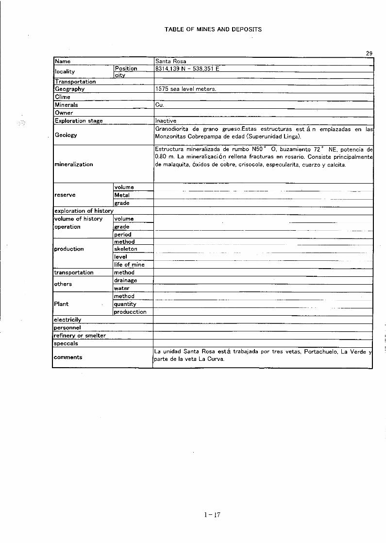
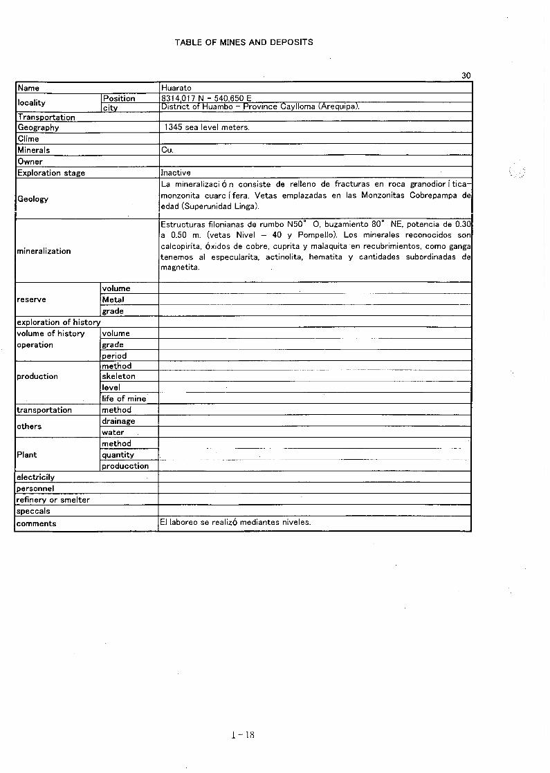
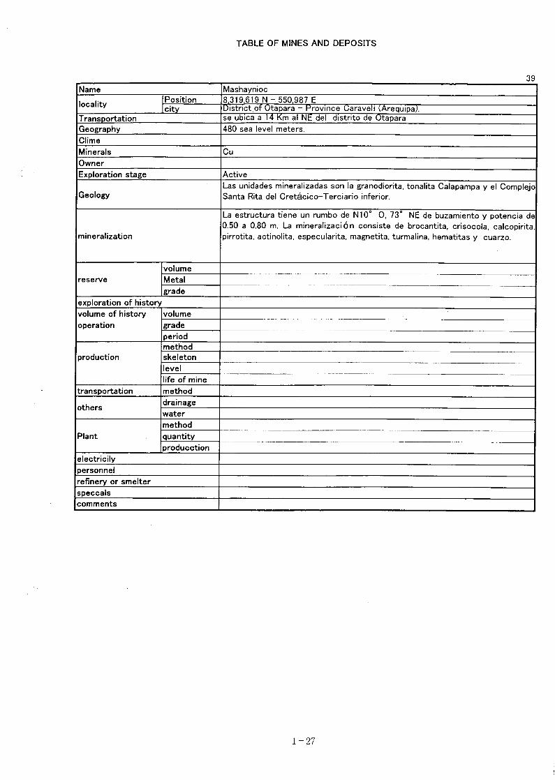
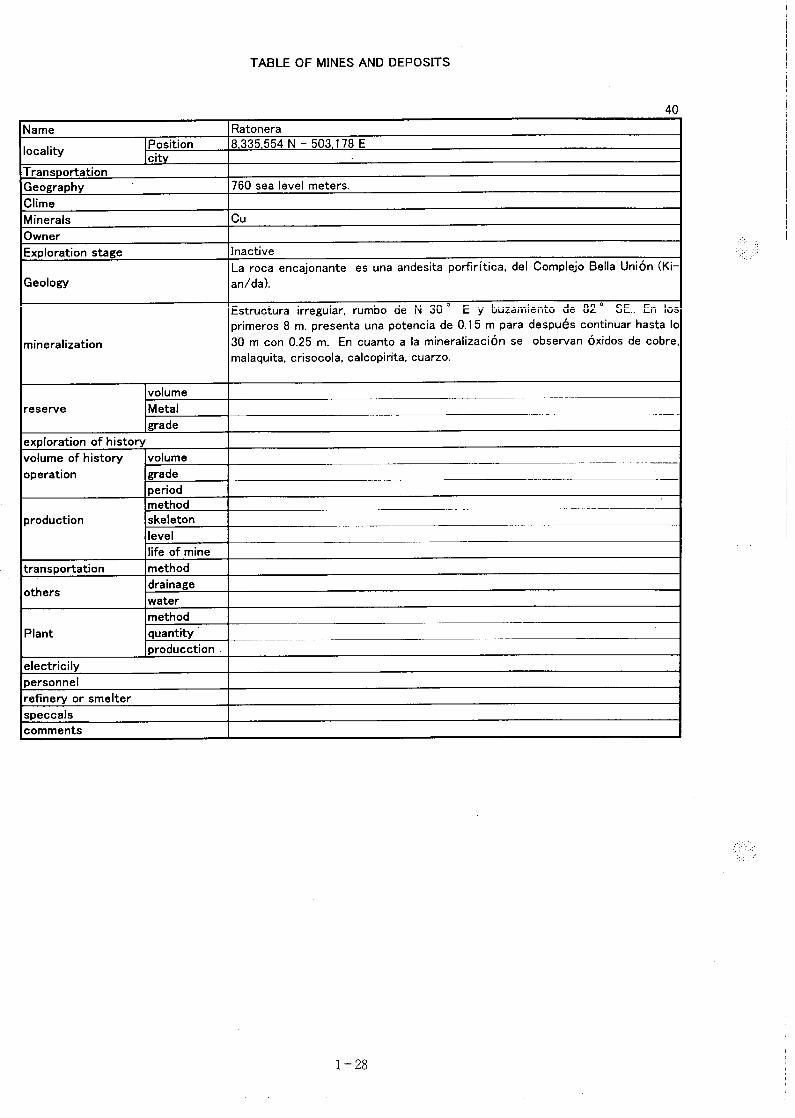
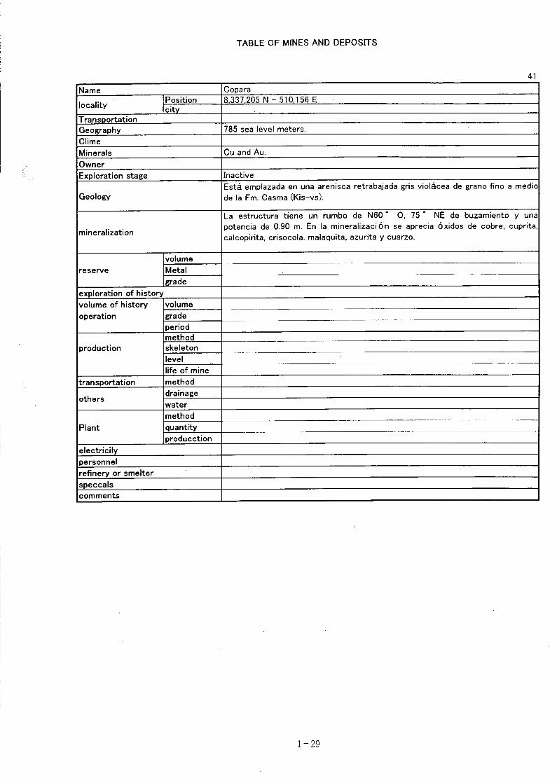
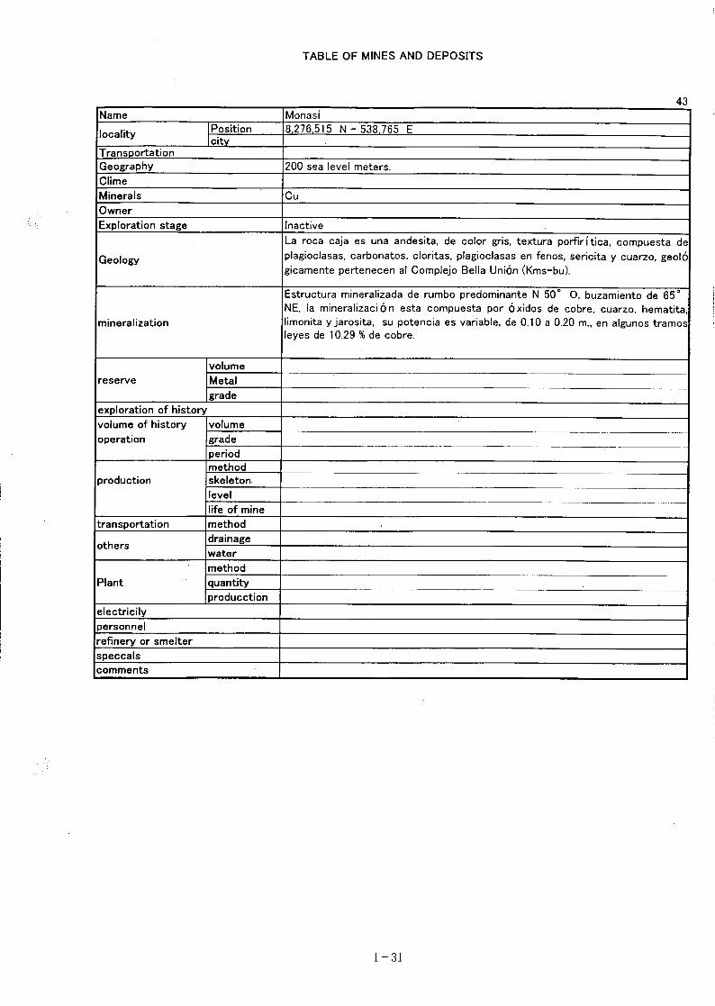
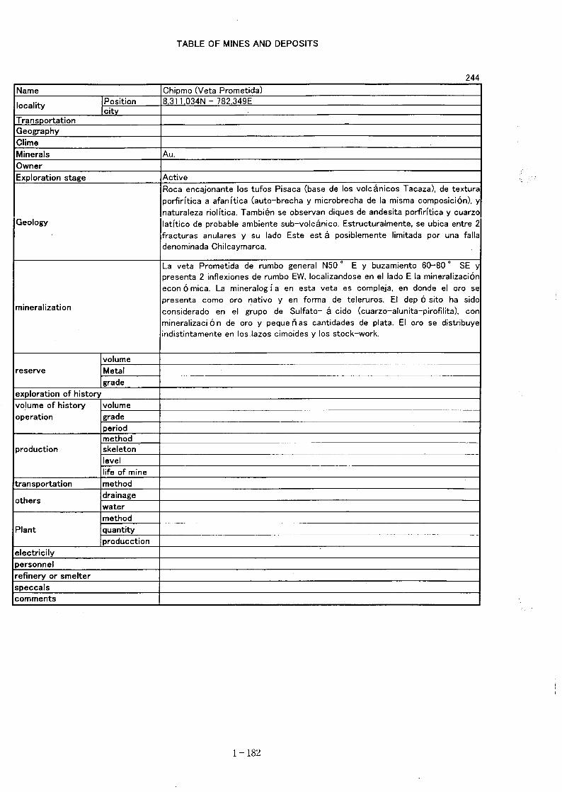
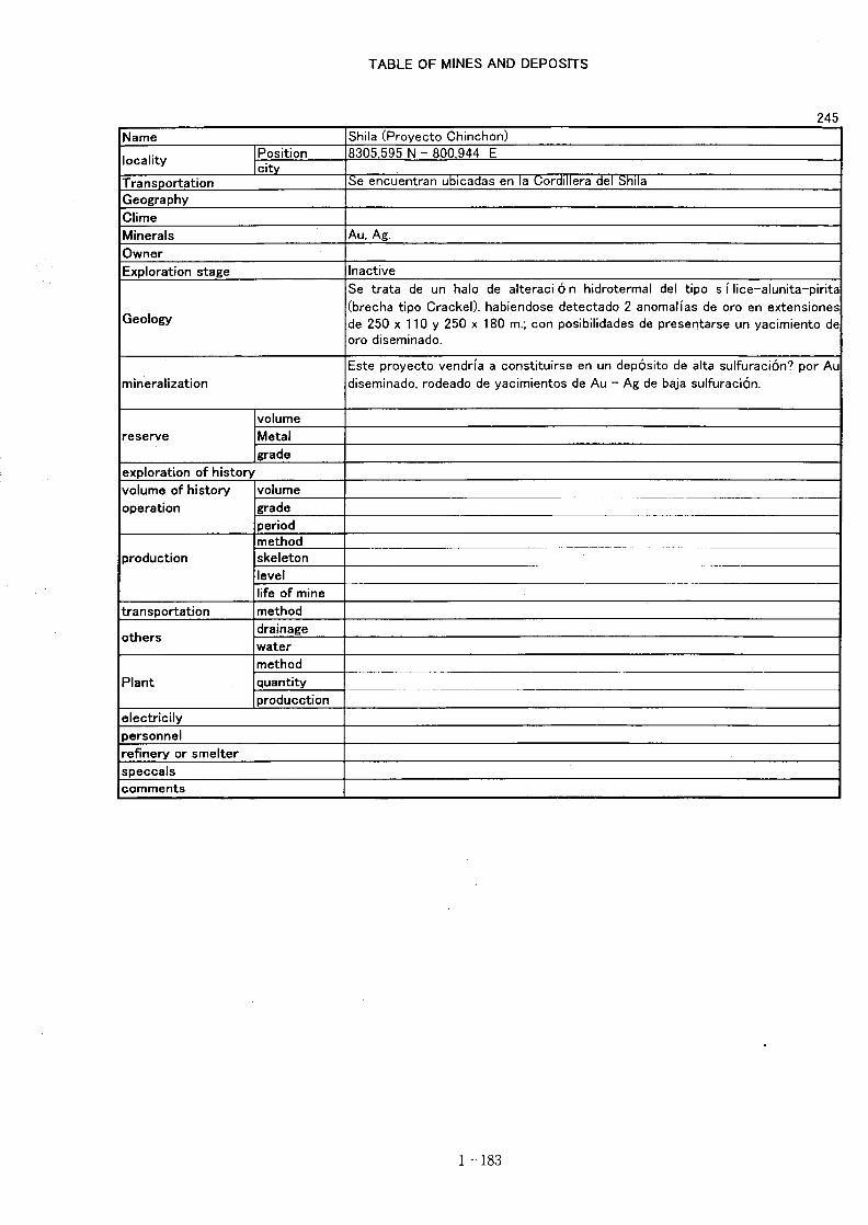
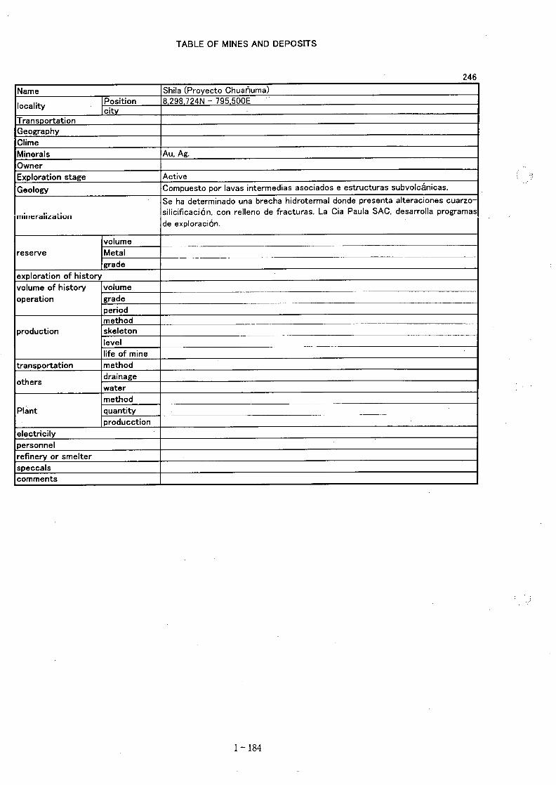
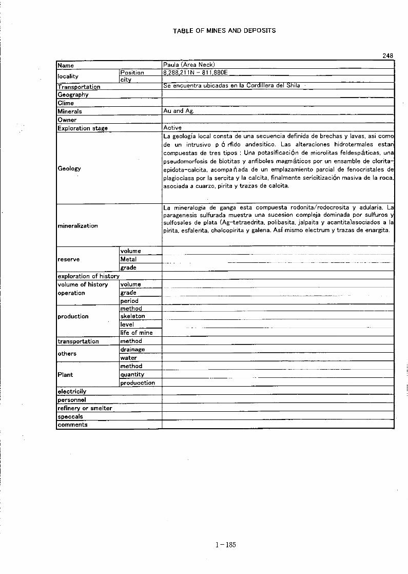
(1) Satellite Image Interpretation
As a result of rationing of satellite image interpretation of this year, a sizable anomaly of R21(iron oxide index) is distributed in the quadrangle of 32-q, 32-r and 31-r in the east of thesurvey area. The anomaly is tend to be larger in the geological units of PN-ta (Holocenepyroclastics) and tend to be smaller in Ks-ti (upper Cretaceous intrusives), JK-yu (Jurassic toCretaceous sediments), Ks-se (upper Cretaceous sediments) and Ks-ar (upper Cretaceoussediments).A sizable anomaly of R57 (clay mineral index) is distributed in the quadrangle of 32-q and 32-rin the east of the survey area, although the anomalies are distributed all over the survey area.They tend to be concentrated in the geological units of PeB (pre Cambrian metamorphics), JK-yu (Jurassic to Cretaceous sediments), Ks-ti (upper Cretaceous intrusives), PN-ta (Neogenevolcanics), NQ-ba (Quaternary volcanics) and Q-and (Holocene pyroclastics). Conspicuousanomalies are located in alluvium and along the existing river. In the east of the area,conspicuous anomalies are located in the units of JK-yu, PN-ta, QN-ba and Q-and.The lineaments of Andes trend (NW-SE) are predominantly distributed in the survey area.However, the lineament of E-W is predominantly distributed in the quadrangles 32-o and 32-p.This is probably due to the effect of Abancay Deflection which deflect the trend of strata to E-W from Andes trend (NW-SE) located to the north of the survey area. Pattern of lineamentdensity is generally conformable to the above-mentioned Andean trend and the deflection. Highlineament density area is coinciding with the area of the deflection. In comparison withgeologic units, the lineament density tend to be lower in the young geological unit e.g. Tertiarysystem and Quaternary system, while lineament density tend to be higher in the old geologicunits, consisting of Paleozoic and Mesozoic formations.Relationship between the result of image interpretation and known mineral showings aresummarized as follows:1. Although the vein type ore deposit predominates over the survey area, a correlationbetween lineament density and distribution of ore deposits is not clear.2. Between the location of vein type deposits and indices of iron oxide and clay mineral, thefollowing relationship is recognized in general.1) In case of ore deposit is located in Cenozoic formation, the ore deposit is accompanied by
either iron oxide index or clay mineral index in any case.2) In case ore deposit is located in Mesozoic or Paleozoic formation, the ore deposit is
accompanied by either index as the case may be.3. Location of manto type ore deposit coincides with the area of high lineament density.4. Neither iron oxide index nor clay mineral index appear in the area of manto type ore deposit.5. Ore deposit of disseminated type and stockwork type is located around the area of relativelyhigh lineament density.6. Ore deposit of disseminated type and stockwork type is commonly accompanied by eitheriron oxide index or clay mineral index even though they are weak. Particularly this is clear inthe case of ore deposit occurs in Cenozoic formation. (2) Existing Data Analysis
Metamorphic rocks, sedimentary rocks and volcanic rocks of pre Cambrian to Quaternary age,elongating northeast to southwest, are widely distributed in the survey area. Penetrating them,intrusive rocks of Ordovician to Silurian, Cretaceous to Paleogene and Neogene in age arelocated. In the southwest and east of the survey area pre-Cambrian metamorphics are
- 119 -
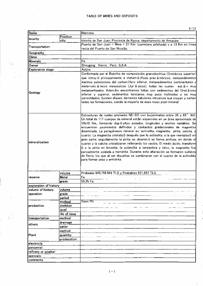
distributed, and the younger sediments and volcanics are orderly distributed to the north.The area is divided into the metallogenic zones of Paracas-Chala, Mala-Nazca, Nazca-Ocoñaand Puquio-Caylloma from the Pacific Ocean side to inland. In comparison with the previousPeruvian metallogenic provinces, Paracas-Chala metallogenic zone corresponds to the cupreoussub-province, the iron ore zone. Mala-Nazca metallogenic zone corresponds to the cupreoussub-province, the copper ore zone, Nazca-Ocoña metallogenic zone corresponds to the cupreoussub-province, the gold ore zone and Puquio-Caylloma metallogenic zone corresponds to thepolymetallic sub-province respectively.Number of ore deposits and mineral showings of this area totaled 260. Among them 238 is veintype deposit, of which 172 is gold vein or gold copper vein, that shows the character of Nazca-Ocoña metallogenic zone. 56 vein type copper deposits show the character of Mala-Nazcametallogenic zone. Manto type deposits totaled 15, of which 12 are manto type iron depositsand two are manto type iron copper deposits. Ore deposits of the Marcona mine, the onlyproducer of iron ore in Peru, are composed of the above two types of manto type deposits.Around the Marcona mine six iron ore veins and three iron copper ore veins are known to occurwhich show the character of Paracas-Chala metallogenic zone. Aside from them the existenceof four dissemination type deposits and three stockwork type deposits is known.Considering mineral paragenesis of those showings, it is very meaningful that a few mineralshowings with only gold occur in volcanic rock of Cenozoic age. That suggest the existence ofgold mineralization related to young volcanism can be expected. Since the host rock of theseshowings are the Tacaza group and the Camaná group of lower Miocene age, the Barroso groupof Pleistocene age, the gold mineralization seems to have taken place continuously fromMiocene to Holocene. The existence of stratabound type ore deposit in the area of gold vein inMesozoic sedimentary rocks is a subject worth studying as there is a description of a smallmanto type copper gold showing in the Seraj formation of Mesozoic age.Metallogenetic study on those ore deposits and mineral showings except for the Marcona minehas not been conducted. From the existing data and distribution of mineral showings,mineralization in the survey area is classified into the following types. · Manto type and vein type iron (copper) deposits related to andesitic intrusives of late
Mesozoic age. · Gold vein, gold-copper vein and copper vein related to the Coastal Batholith of late
Cretaceous to Paleogene age. · Vein type, dissemination type and stockwork type gold deposit related to volcanic rocks of
Miocene to Holocene age.Among the above types of mineralization, the target of this survey is to be placed primarily onthe gold deposit related to volcanics of Miocene to Holocene age and secondarily the gold veinrelated to the Coastal Batholith. (3) Overall Analysis
Based on the results of the satellite image analysis and existing data analysis,1) Iron oxide index anomaly obtained by satellite image analysis2) Clay mineral index anomaly obtained by satellite image analysis3) Density of lineament4) Distribution of volcanic rocks of Miocene to Pleistocene5) Distribution of the Guaneros formation, the Yura group and the Casma group of Mesozoic
age6) Location of known mineral showings
From the above basis the following five area s are selected as a promising area.
- 120 -

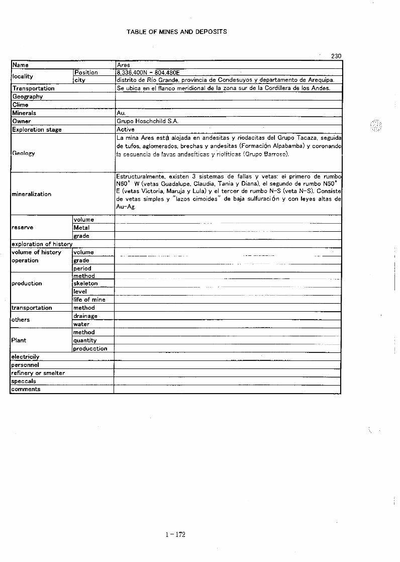
① Nazca area② Tocota area③ Chuquibamba area④ Andagua area⑤ Orcopampa area
Basis of the judgment is indicated in the following table.
Table of Promising Area
Area CenterCoordinates
R21(Iron
Oxide Index)
R57(Clay Mineral
Index)
LineamentDensity
ObjectiveCountry Rocks
KnownIndication
①Nazca 14゚25’S
75゚15’W
Weak nearYura Group
Small scaled inYura G., trends
NW-SE
High densitySummit
JK-yu(Yura Group)
Au Vein type
②Tocota 15゚40’S
74゚10’W
Small scaledwithin Guanero
s Formation
Medium scaledalong fault
system in Guaneros F.
High density3 summits
Js-gu(Guaneros F.)
JK-yu(Yura Group)
Au Vein type
③Chuqui-
bamba
15゚40’S
72゚45’W
Large scaledwithin Tacaza G
roup andcontinue to Barr
oso Group
Small scaledin Tacaza G.
and Barroso G.Overlap to R21
in part
Saddle Between highdensity summi
ts
PN-ta(Tacaza G.)
NQ-ba(Barroso G.)
AuDissemination
type
④Andagua 15゚30’S
72゚25’W
Large scaledwithin Tacaza G
roup andcontinue to Barr
oso Group
Small scaledin Tacaza G.
and Barroso G.Overlap to R21
in part
High density2 summits
PN-ta(Tacaza G.)
NQ-ba(Barroso G.)
nothing
⑤Orcopampa 15゚20’S
72゚15’W
Large scaledwithin Tacaza G
roup andcontinue to Barr
oso Group
Medium scaledin Tacaza G.
and Barroso G.Overlap to R21
in part
High density4 summits
PN-ta(Tacaza G.)
NQ-ba(Barroso G.)
Au Vein typeDissemination
typeStockwork
type
- 121 -
Chapter 2 Recommendation in Future
As this year’s survey and analysis revealed that the survey area is promising in potential formineral resources, a field survey to confirm the potential is to be conducted in future.In conducting the ground survey it is important not only to make a correct interpretation oneach geological fact, but also to consider the position of each geological fact in the wholegeological setting of the area. Understanding of the regional geological character is alsoimportant. The main objects of survey in the selected district are described as follows;
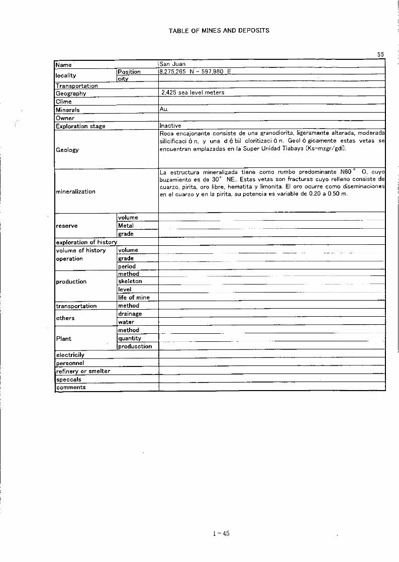
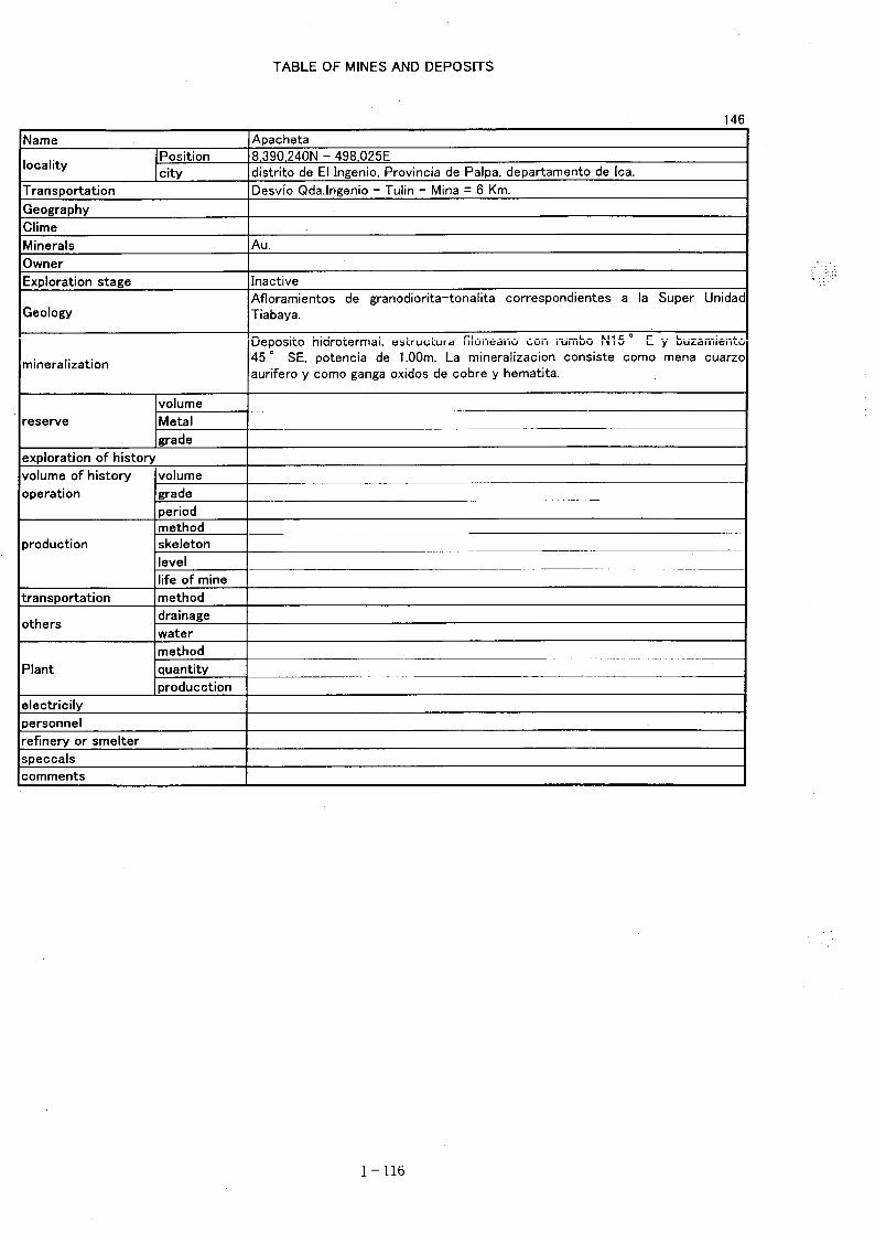
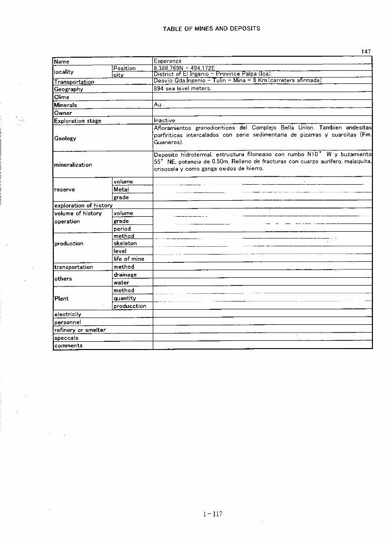
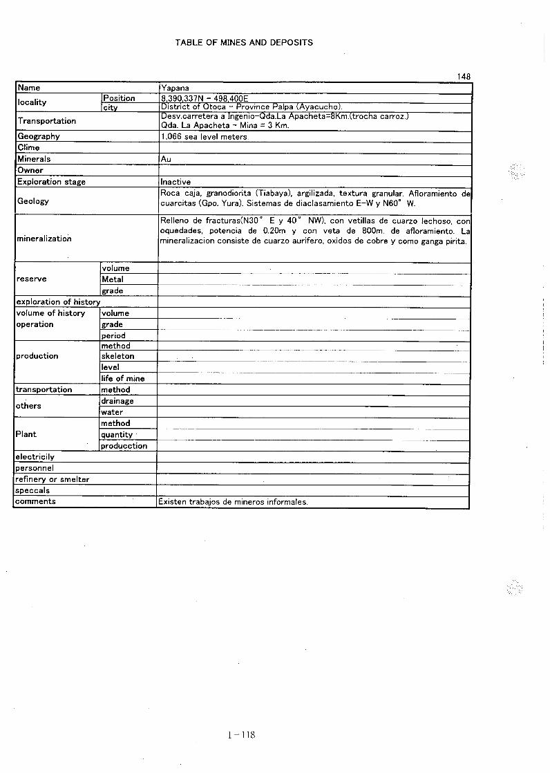
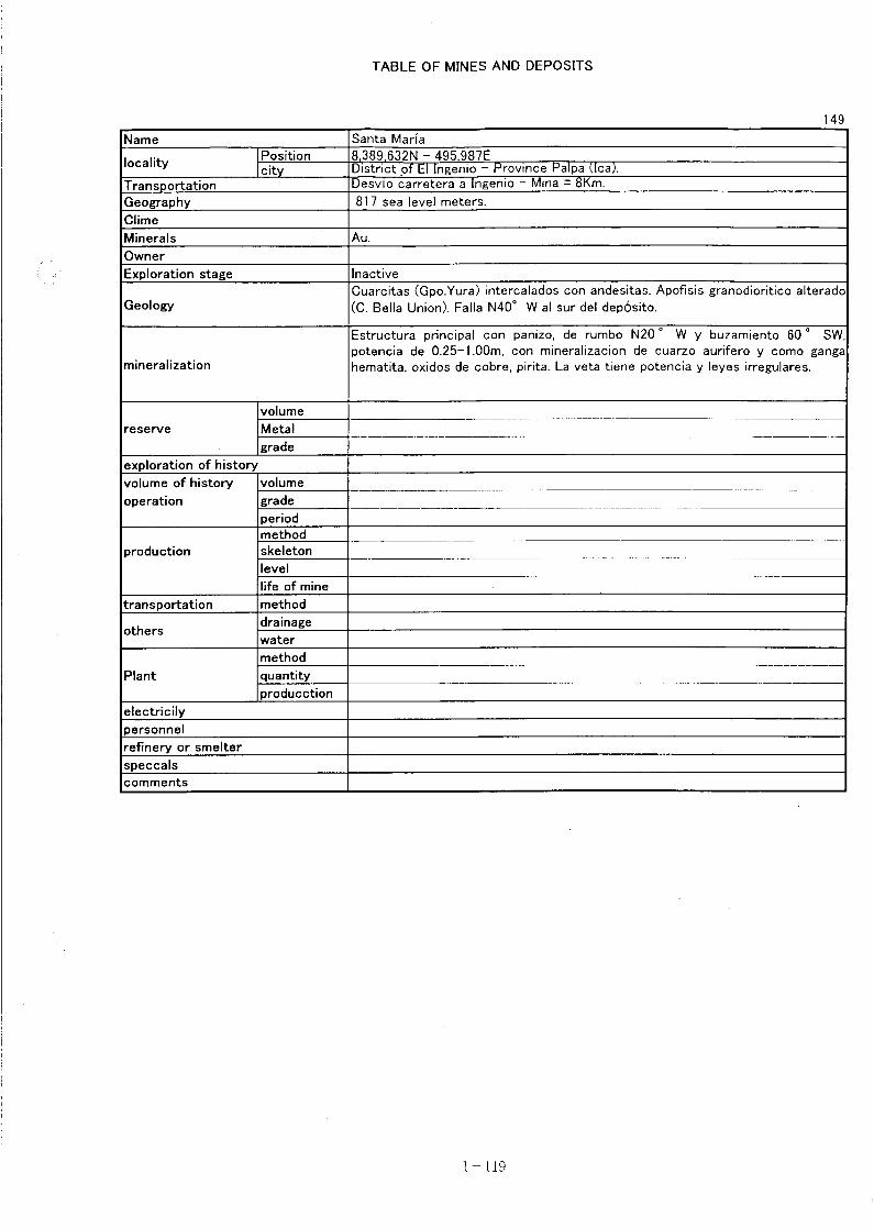
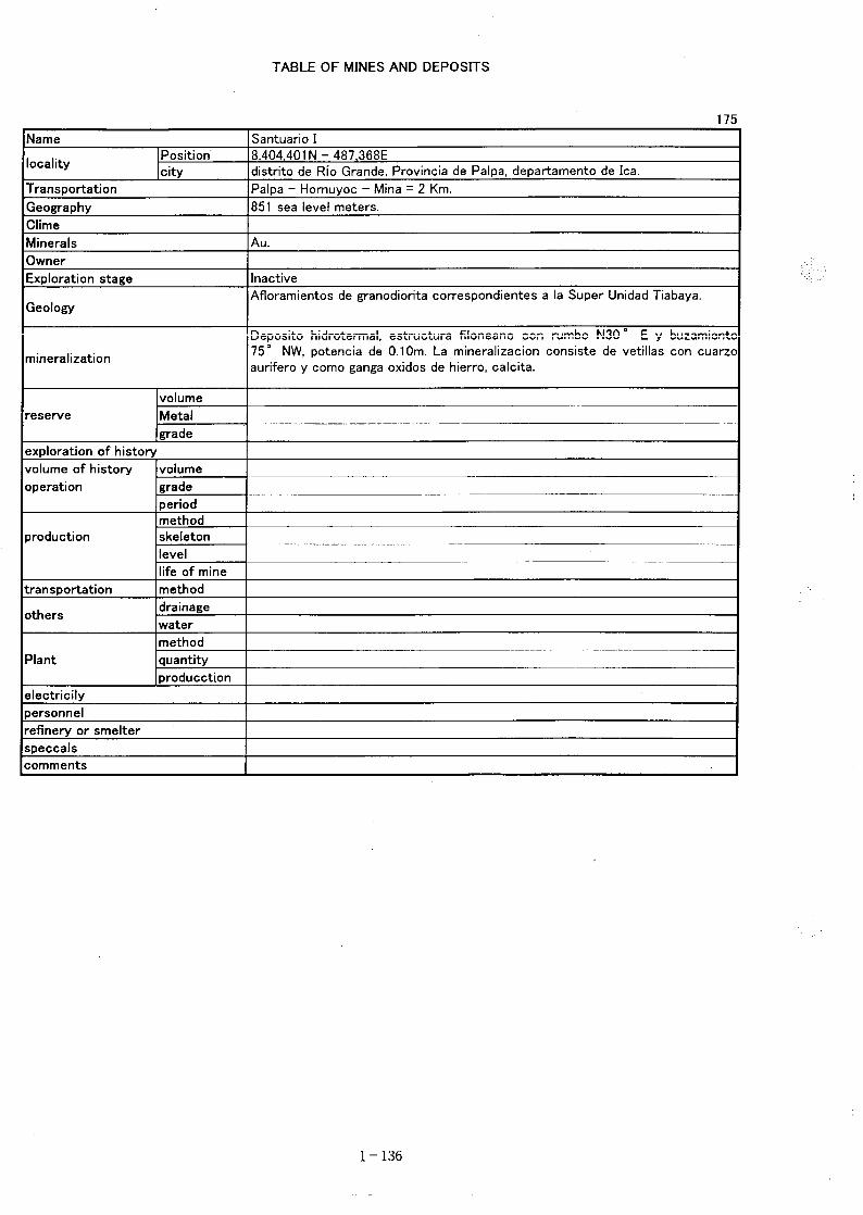
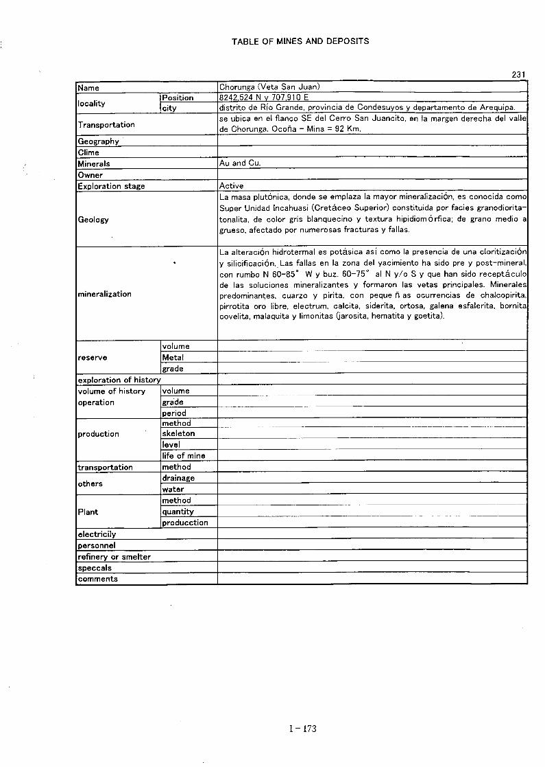
① Nazca areaThe district is widely underlain by the Yura group of Mesozoic age. Intrusive rock of the TibayaSuper unit is extensively distributed in the north and south of the district. Occurrence of anumber of vein type gold deposits is known.
Therefore, in order to obtain the data of gangue mineral composition, formation temperature ofore deposits, wall rock alteration, a field survey is to be conducted. Then the possibility ofexistence of concealed stratabound deposit is to be studied.
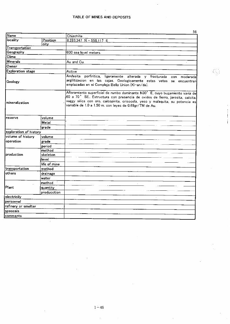
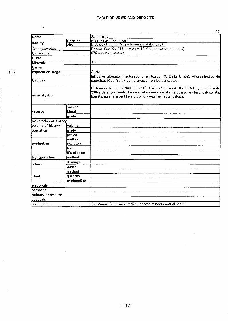
② Tocota areaThe area is widely underlain by the Guaneros formation. The Tibaya Super unit and the BellaUnion complex are distributed in the north of the area, where vein type gold deposits areconcentrated. A small anomaly of clay mineral index is located near the contact of the TibayaSuper unit in the east of the area. A part of the above anomaly is overlapped by the anomaly ofiron oxide index.
Therefore, in order to obtain the data of gangue mineral composition, formation temperature ofore deposits, wall rock alteration, a field survey is to be conducted. Then the possibility ofexistence of concealed stratabound deposits in the Guaneros formation and metasomaticdeposits in the eastern part of the area is to be studied.
③ Chuquibamba areaThe area is distributed by extensively the Miocene Tacaza group and the Pleistocene Barrosogroup. The district is located on the north of high density area of lineament. A number of ironoxide index anomalies are concentrated and a part of them are overlapped with a scattered claymineral index anomaly. Existence of an indication of disseminated type gold deposit is known.
Therefore, to verify wall rock alteration zone that was extracted from the image and to collectgeological data including rock specimen, a field survey is to be conducted. An overall analysisof the data of alteration mineral composition, formation temperature of alteration minerals,assay result of rock specimen etc. is to be conducted to find the possibility of existence ofepithermal gold deposit is to be studied.
④ Andagua areaThe area is overlain by the Miocene Tacaza group and the Pleistocene Barroso group. Theelevated lineament density zone including high lineament density peaks with trend of NW-SE islocated in the area. Small anomalies of iron oxide index are concentrated and a part of them areoverlapped with a scattered anomaly of clay mineral index. There is none of known mineralshowing.To verify wall rock alteration zone that was extracted from the image and to collect geologicaldata including rock specimen, a field survey is to be conducted. An overall analysis of the data
- 123 -
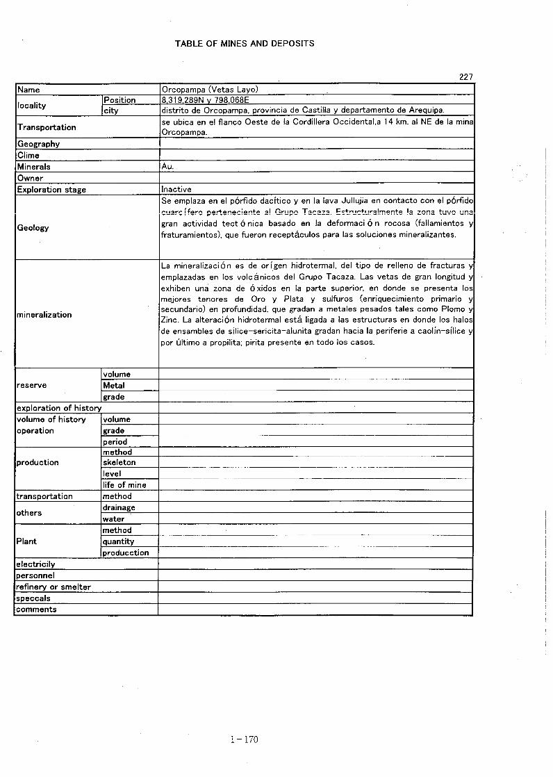
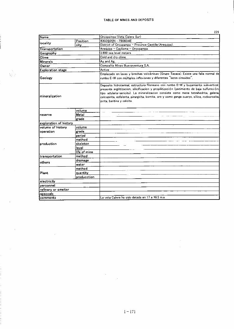
of alteration mineral composition, formation temperature of alteration mineral, assay result ofrock specimen etc. is to be conducted to find the possibility of existence of epithermal golddeposit is to be studied. ⑤ Orcopampa areaThe area is overlain by mainly the Miocene Tacaza group , the Pleistocene Barroso group andthe Holocene pyroclastics. And the area locates in the elevated zone of the lineament highdensity including high lineament density peaks. Concentration of anomalies of iron oxide indexis recognized. And a part of them are overlapped with the anomaly of clay mineral index. Thereis an operating mine in the area.Therefore, to verify the wall rock alteration zone, which was extracted from the image and tocollect geological data including rock specimen. A field survey is to be conducted. An overallanalysis of the data of alteration mineral composition, formation temperature of alterationmineral, assay result of rock specimen etc. is to be conducted to find the possibility of existenceof epithermal gold deposit.
It is recommended to conduct a field survey in consideration of the above-mentioned matter.
- 124 -
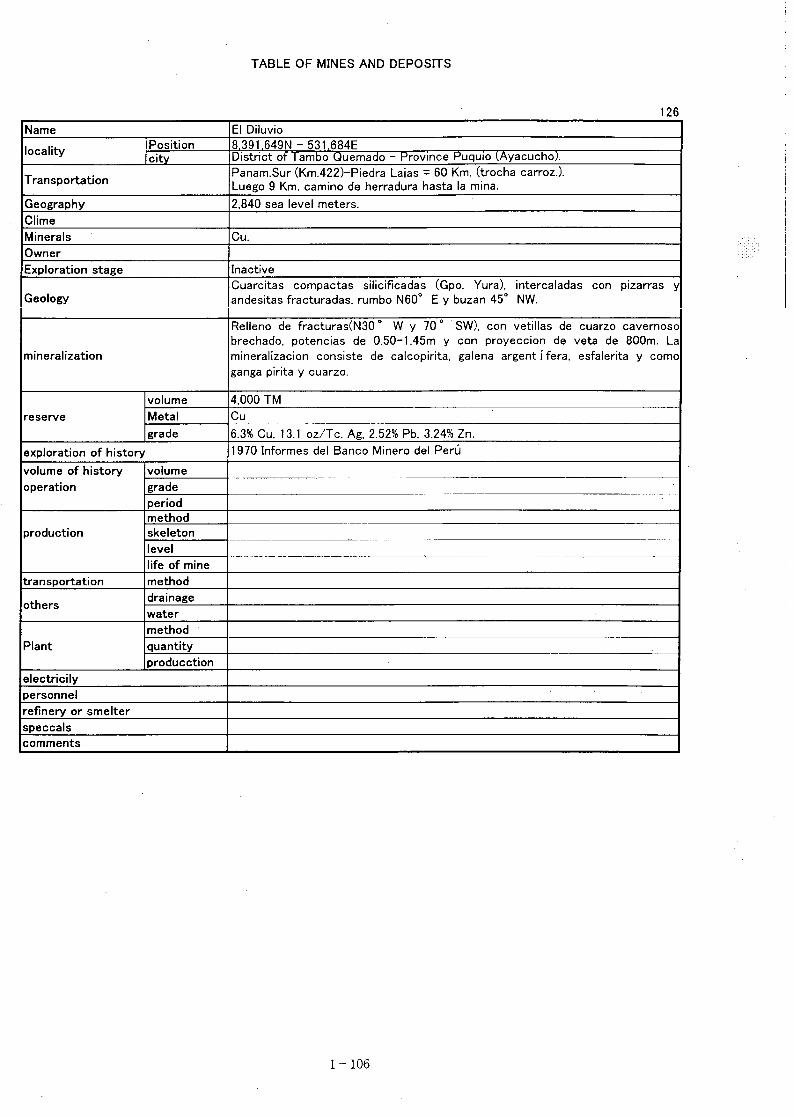
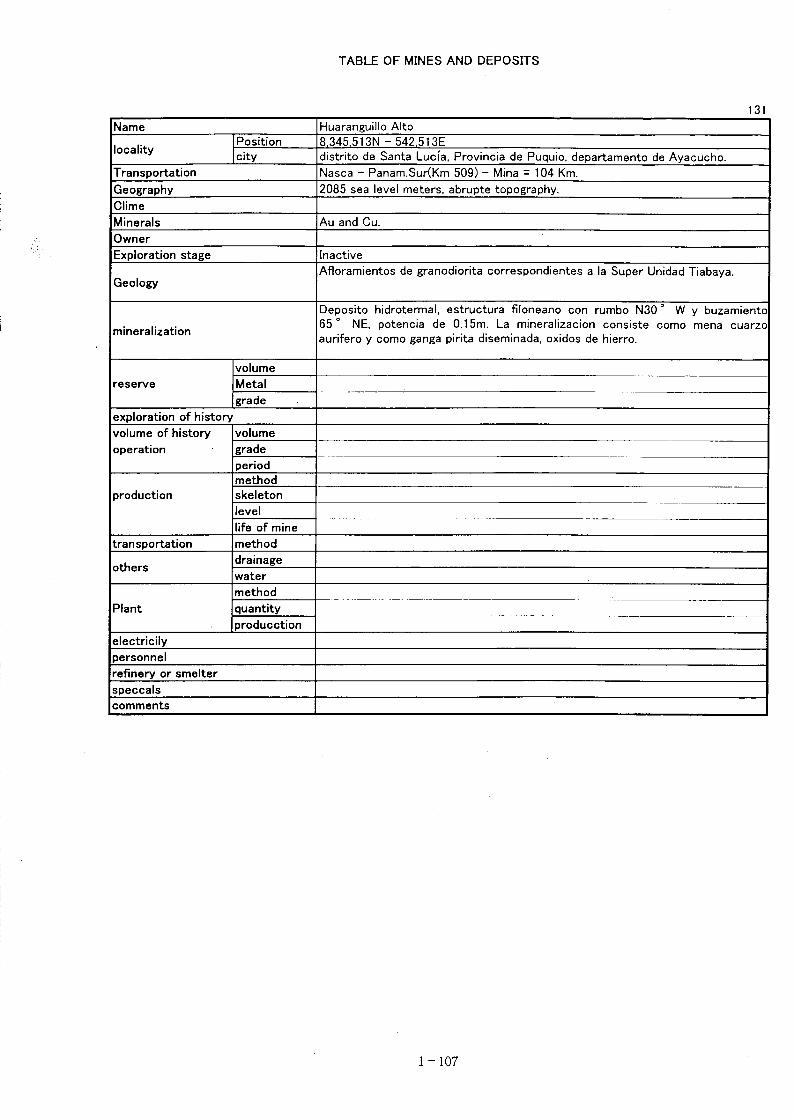
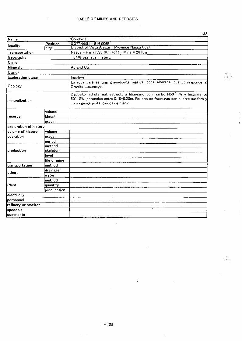
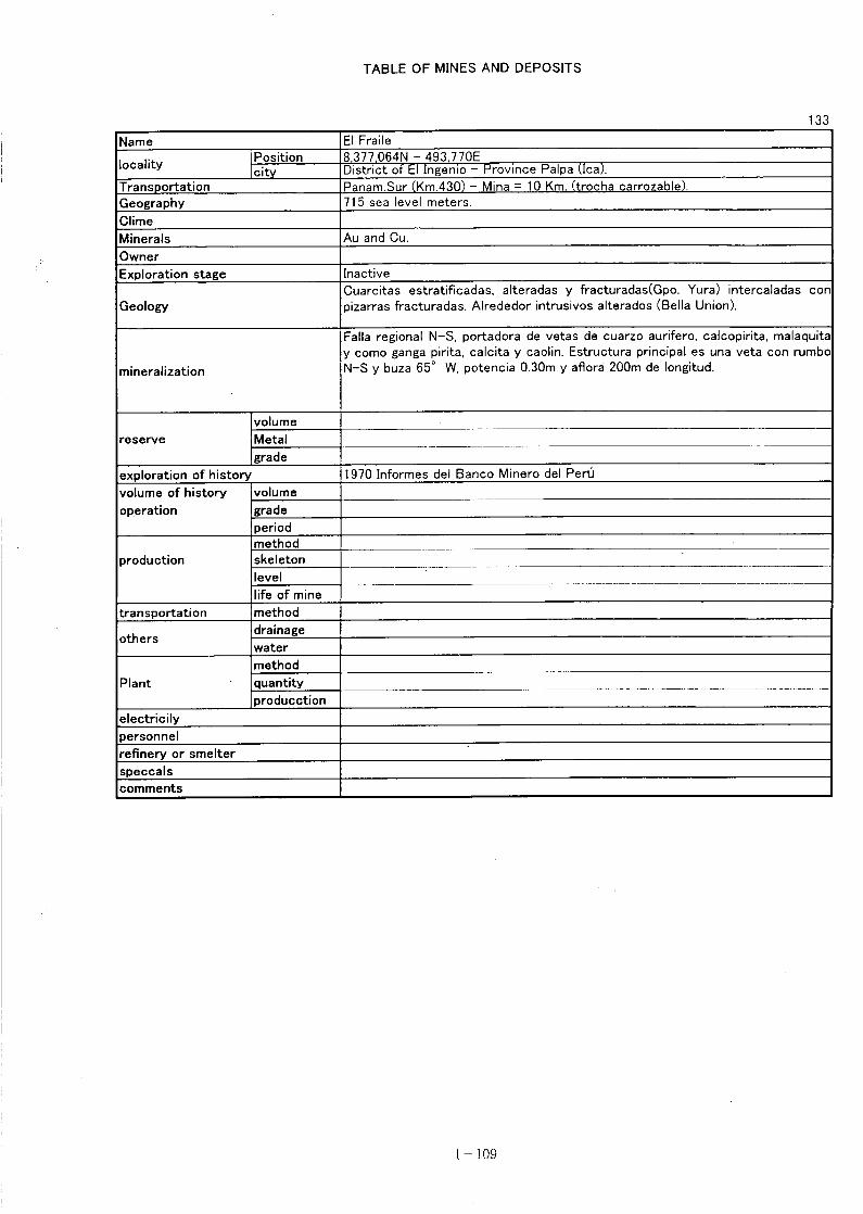
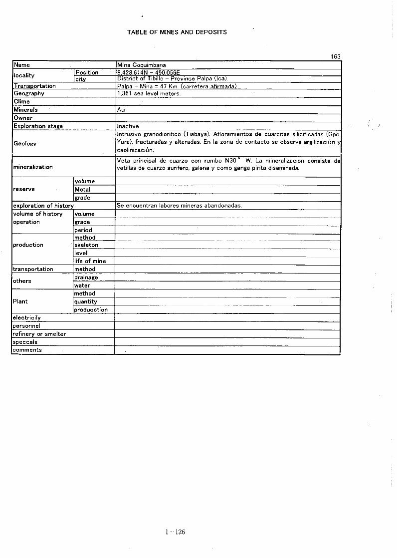
- 125 -
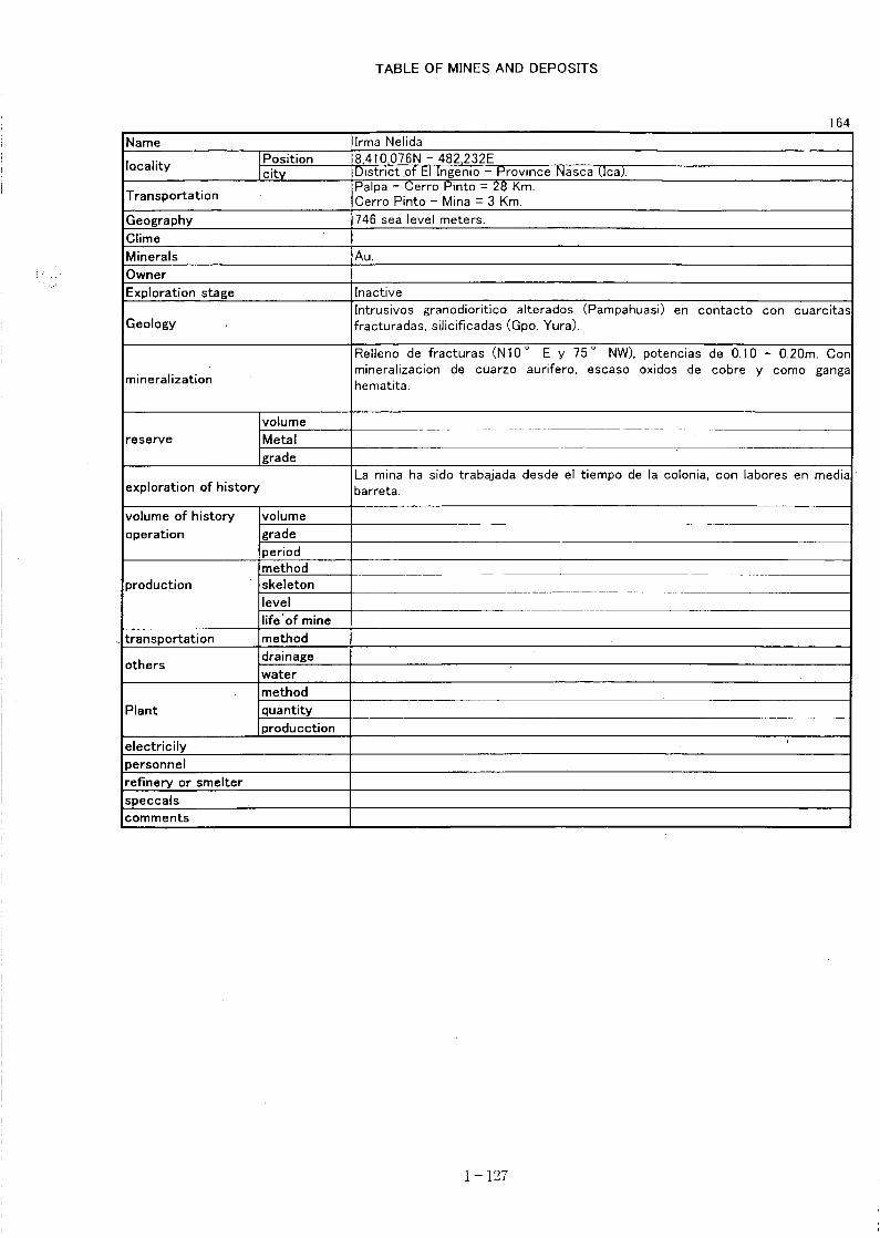
- 126 -
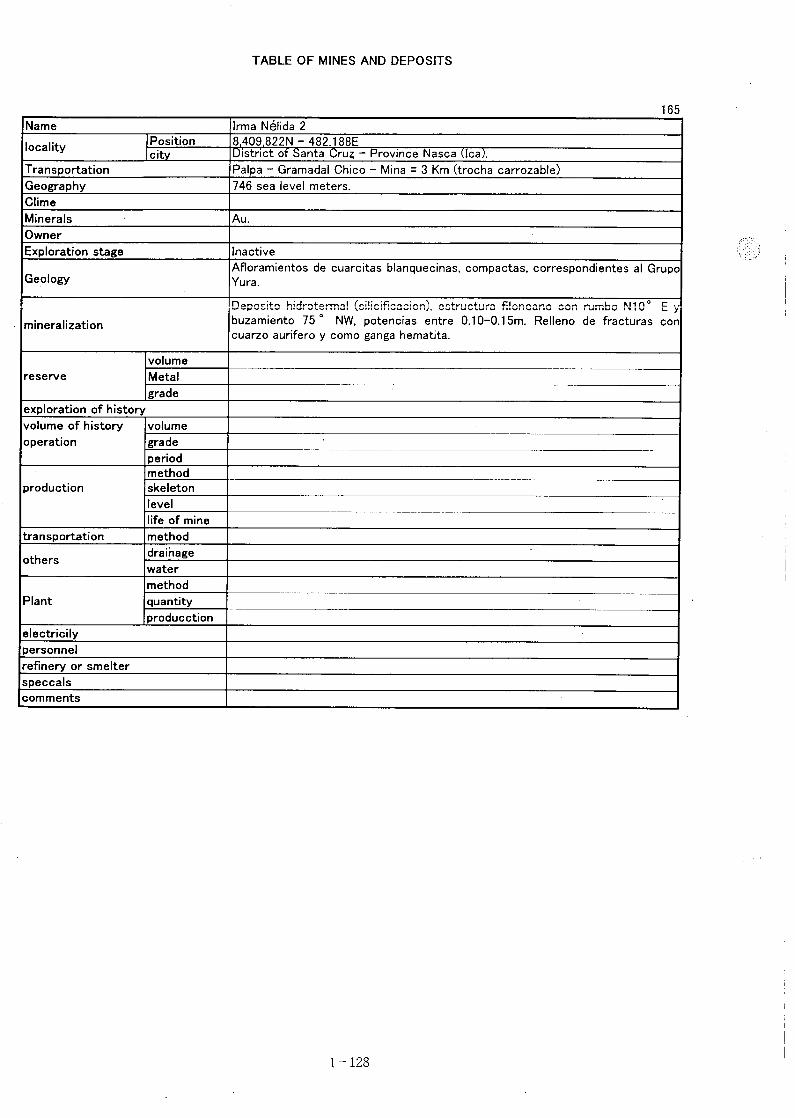
- 127 -

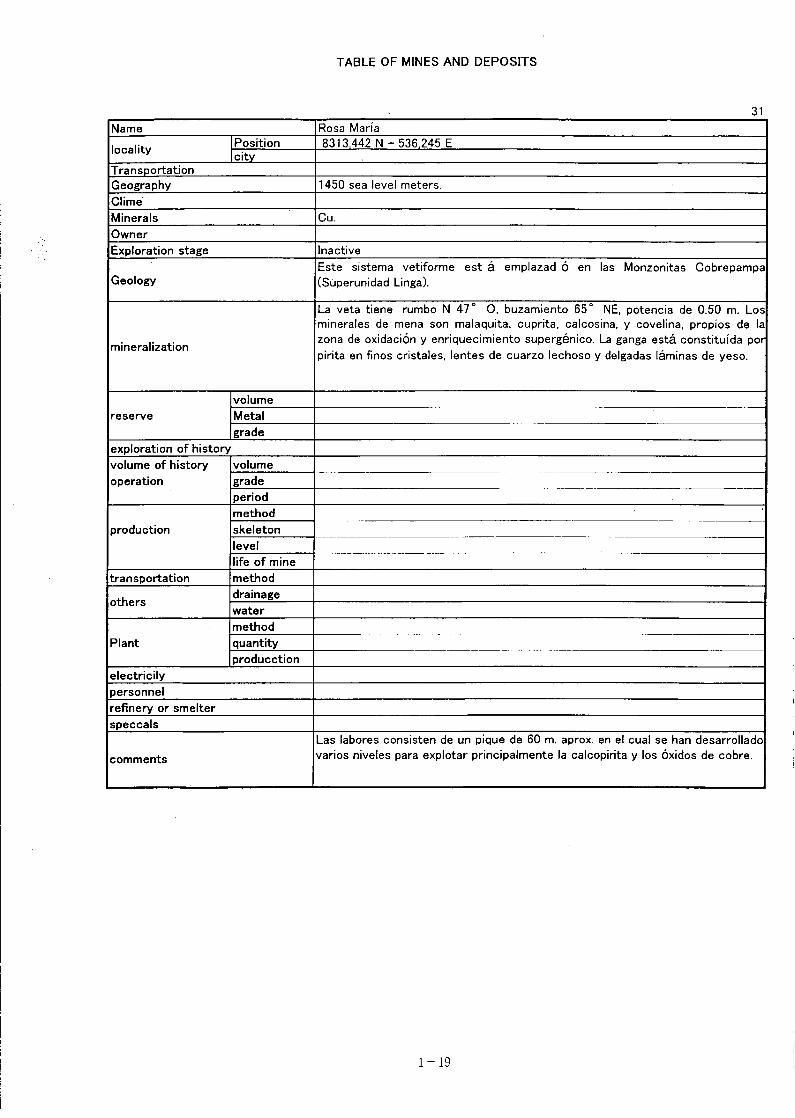
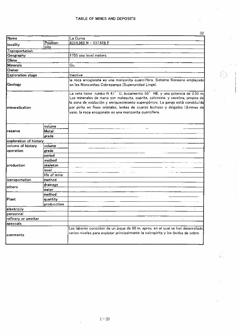
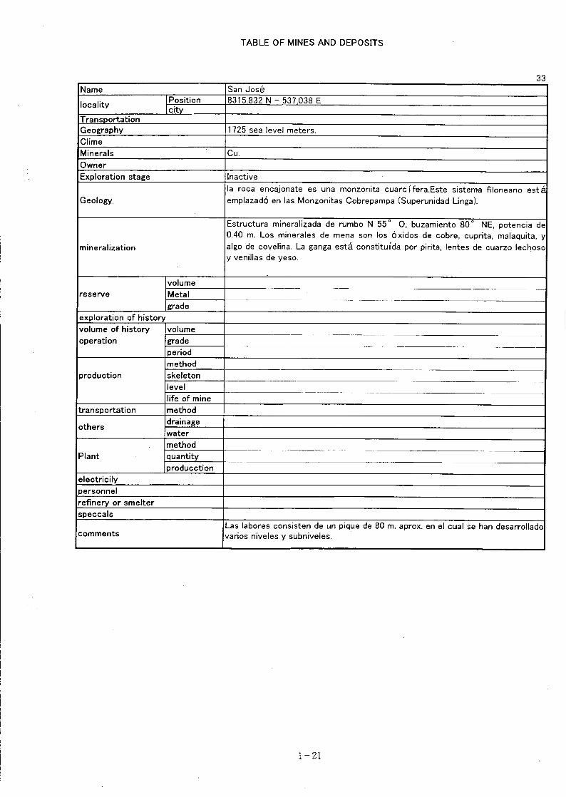
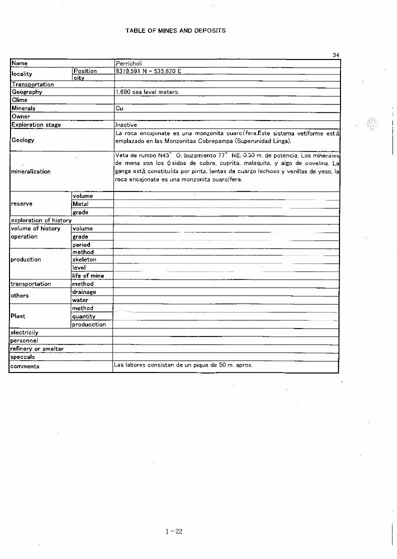


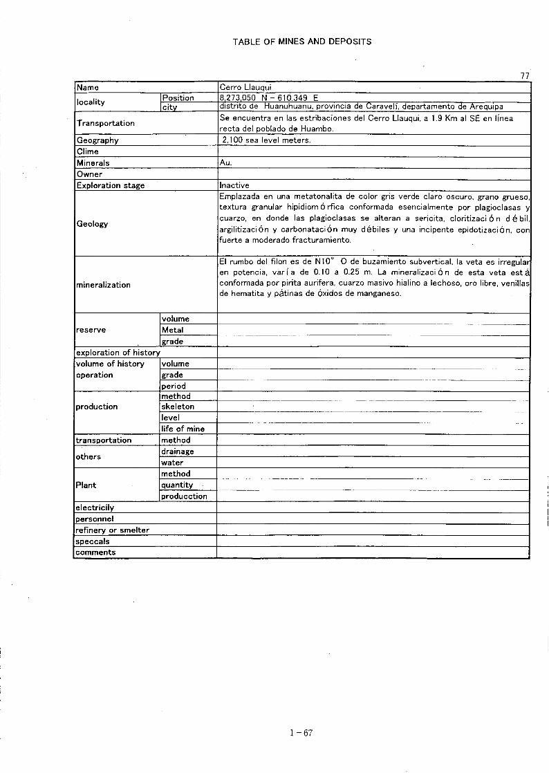
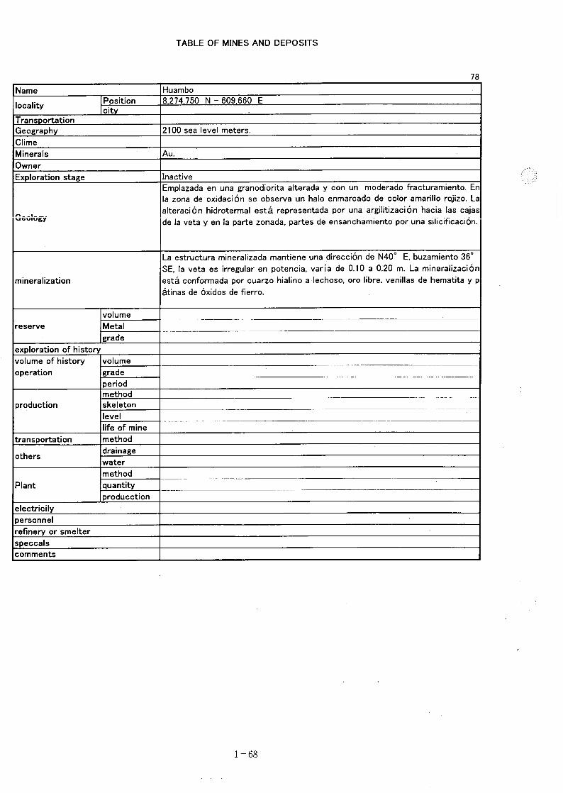
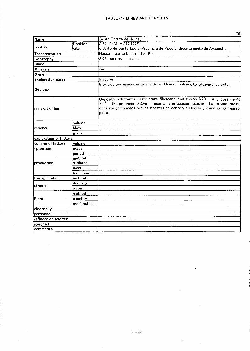
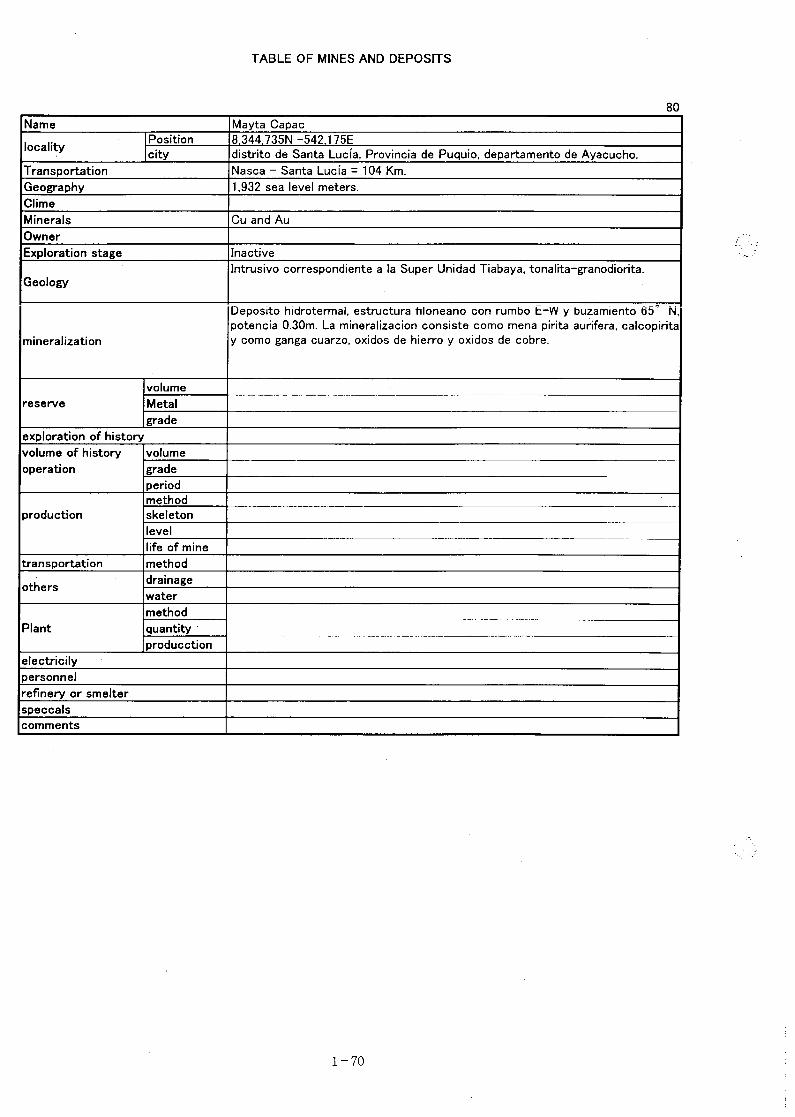


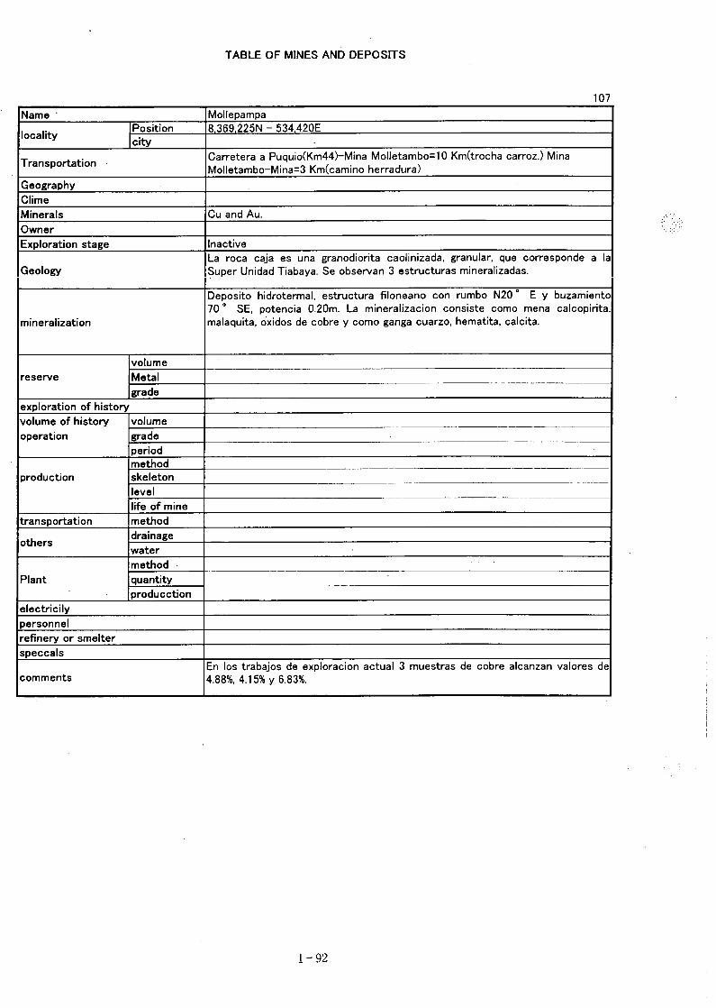
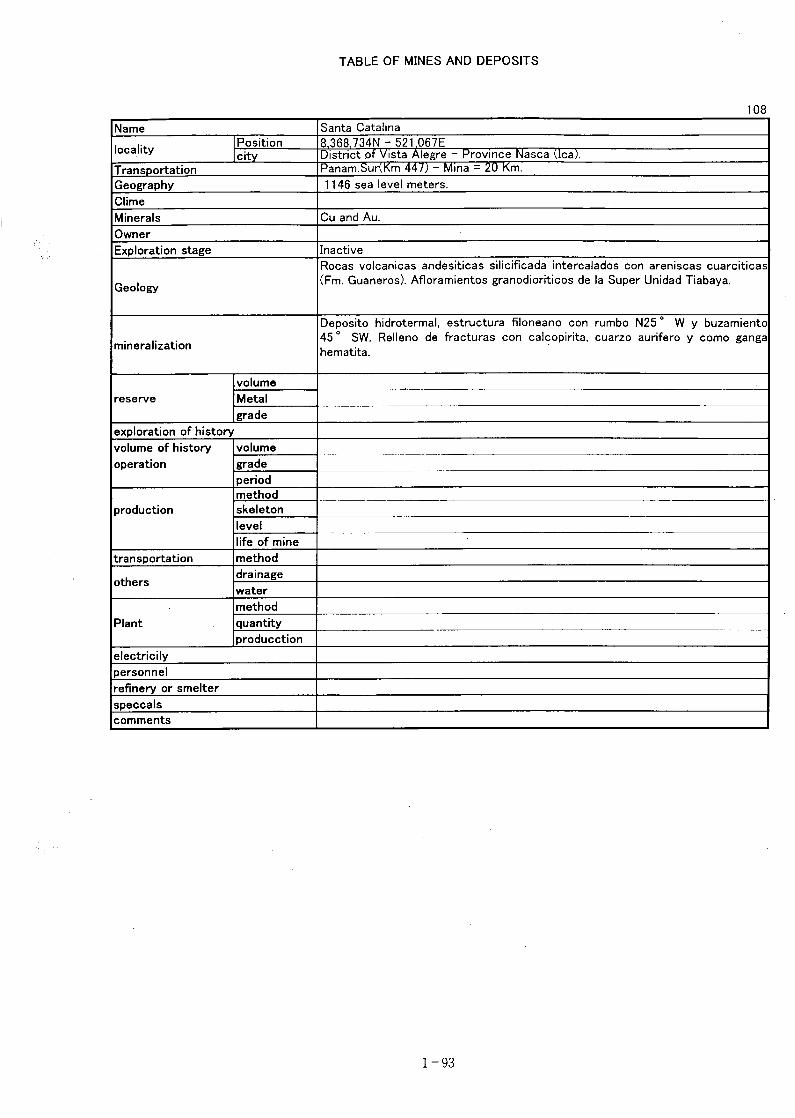
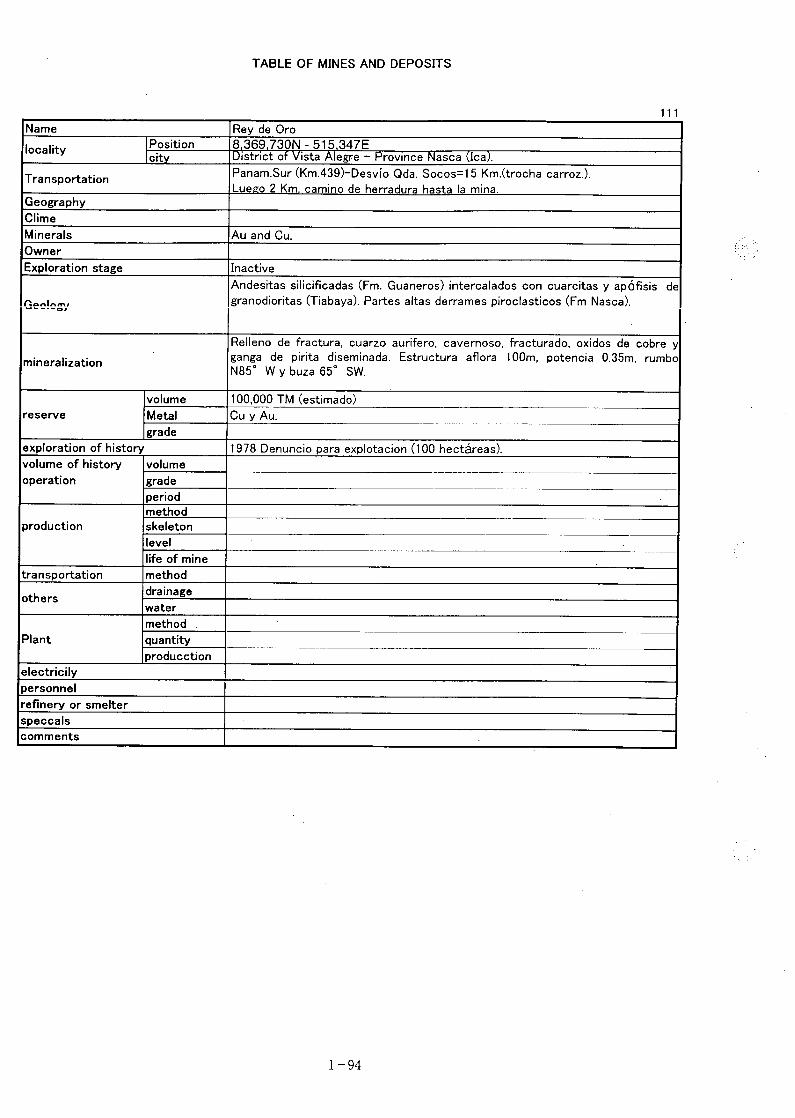
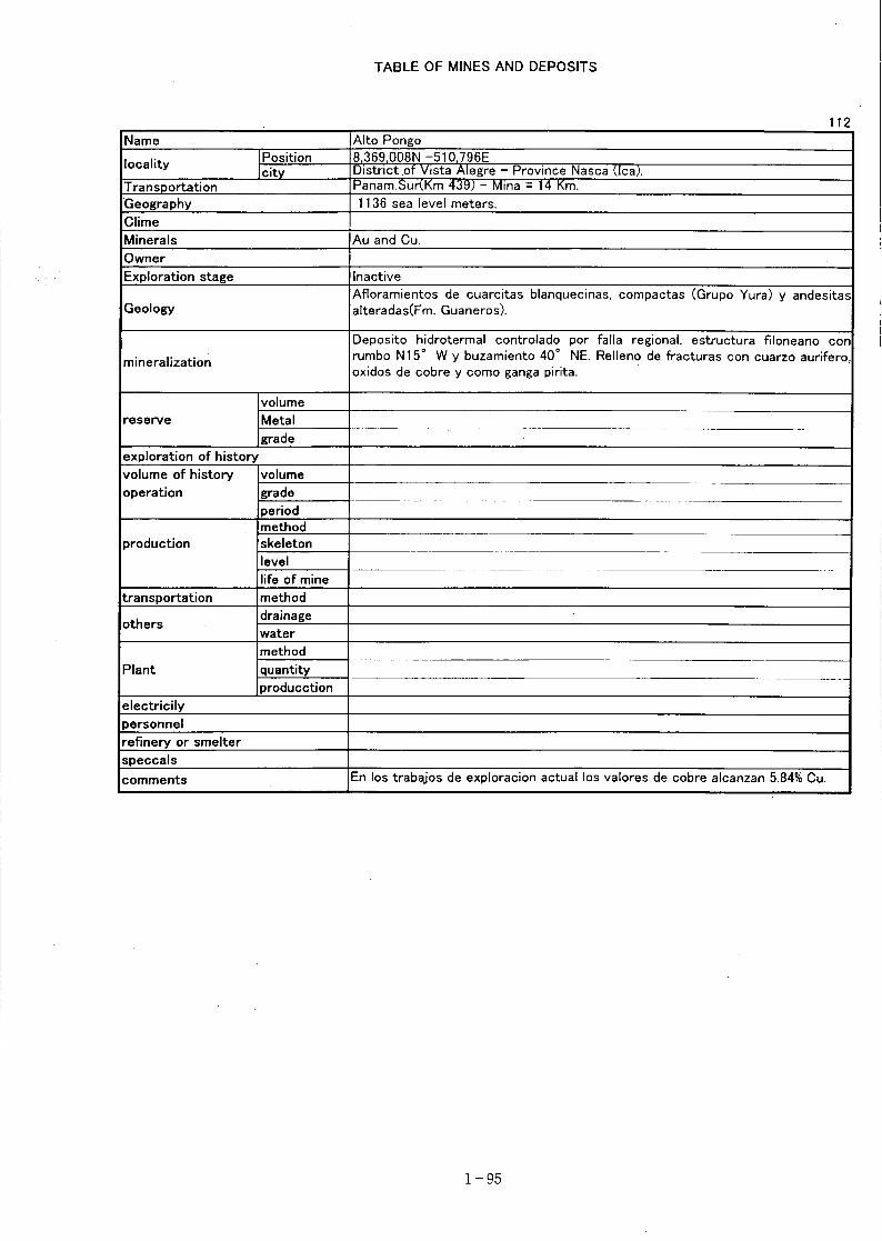


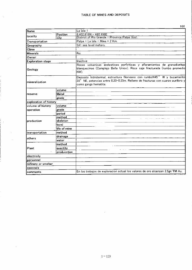


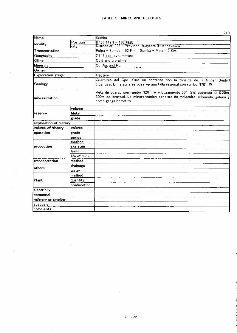
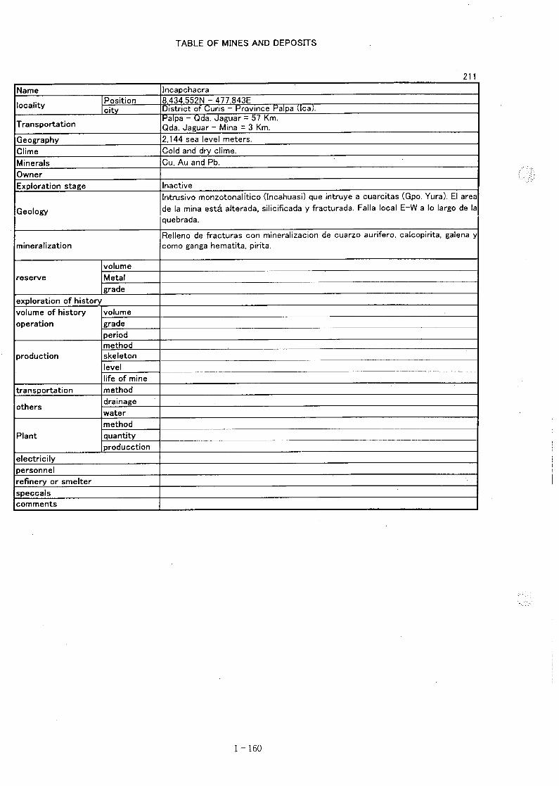


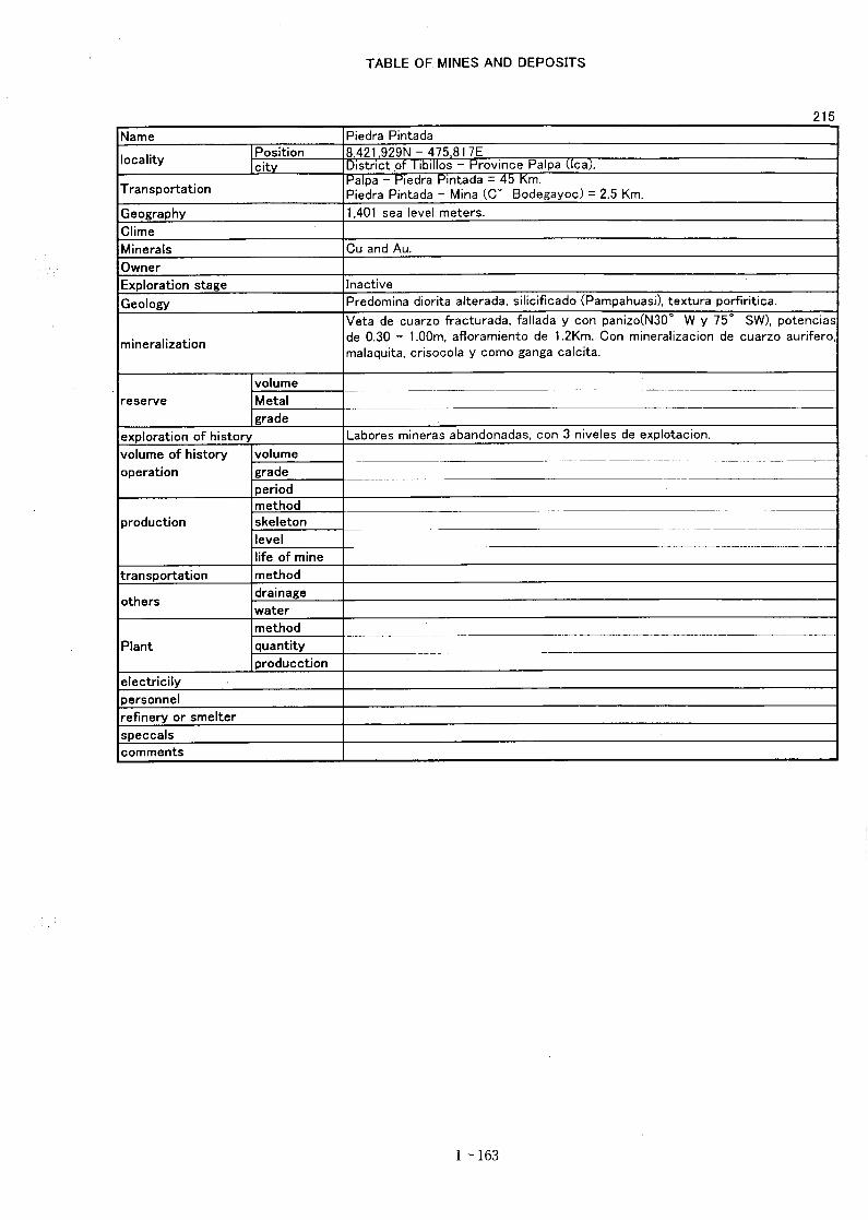
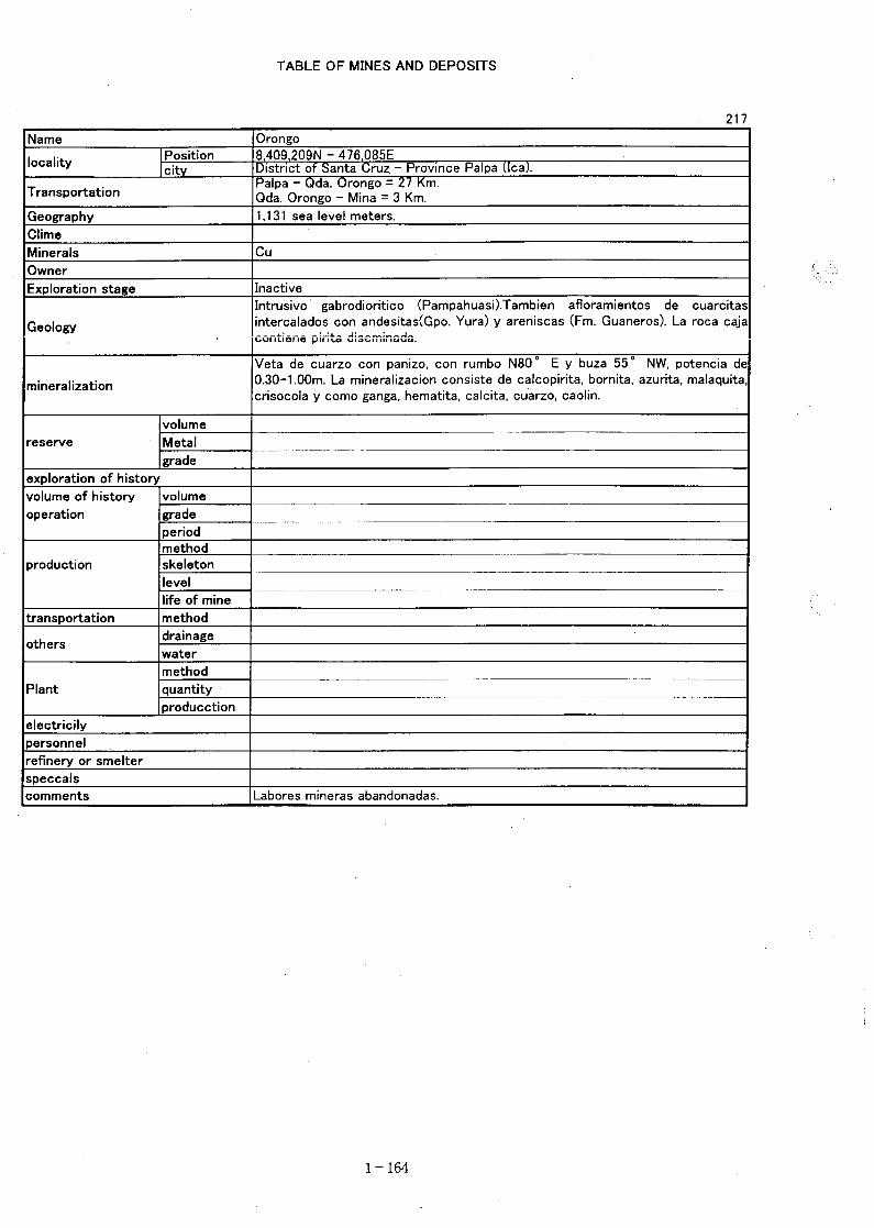
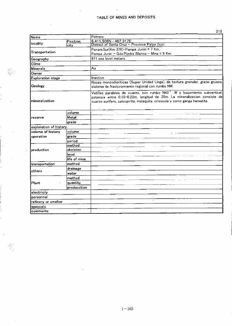

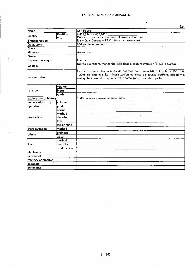
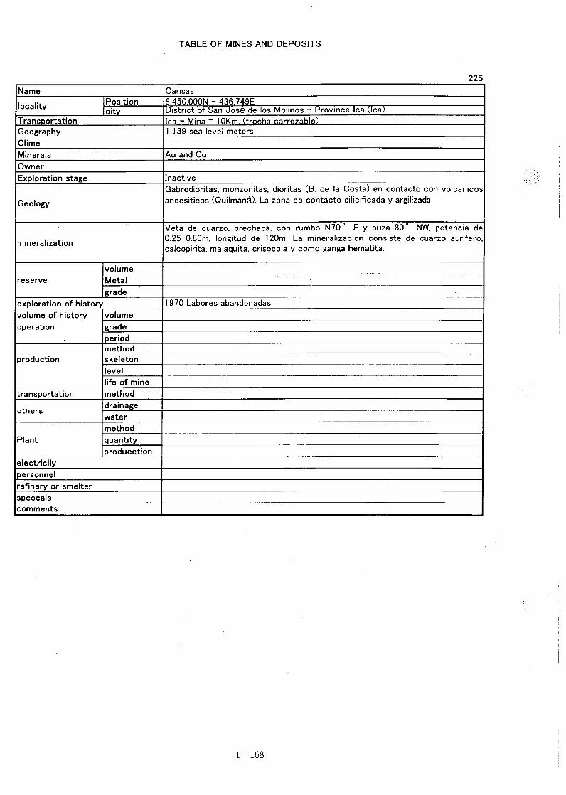
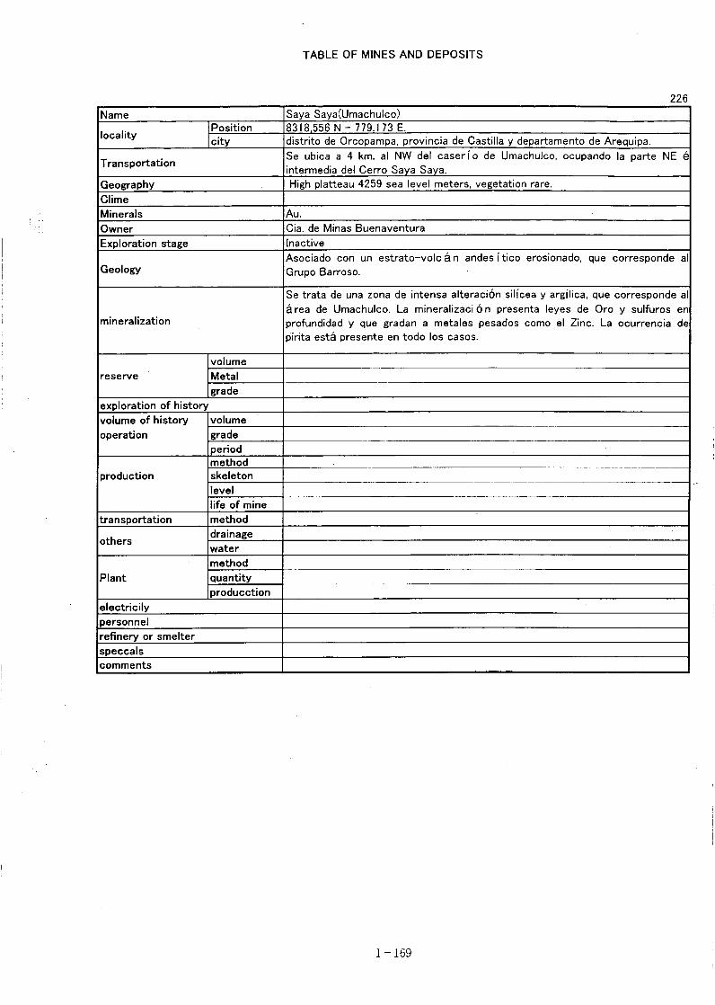
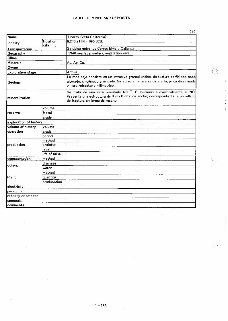
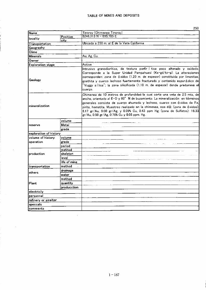
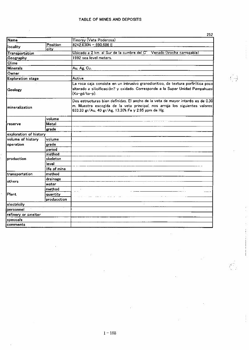
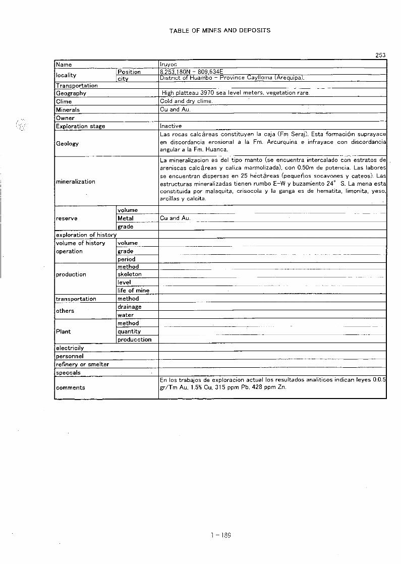


Confirmation Survey of the First Year Extracted Areas
In consideration of iron oxide index, lineament density which are obtained by satellite imageanalysis, and the age and rock facies of intrusives, character of the known mineral showingswhich are obtained from the existing data analysis, five districts namely Calhuahuacho, Livitaca,Macusani, Usicayas and Vilque were selected for a field survey to confirm the above geologicalfactors. The INGEMMET has conducted a field survey for 30 days in the above five districts,and prepared a report "Informe de la verificación de campo de las anomalías Espectrales -Franja 2". The field survey, using rock geochemical survey at the same time, was conducted inthe area of anomaly where mineral claim was not applied. 35 elements of which 34 are assayedby ICP, in addition to Au by fire assay. The assay result is shown in Table 1. The area ofselected districts and the surveyed districts is shown in Fig.1.Result of the field survey is as follows:
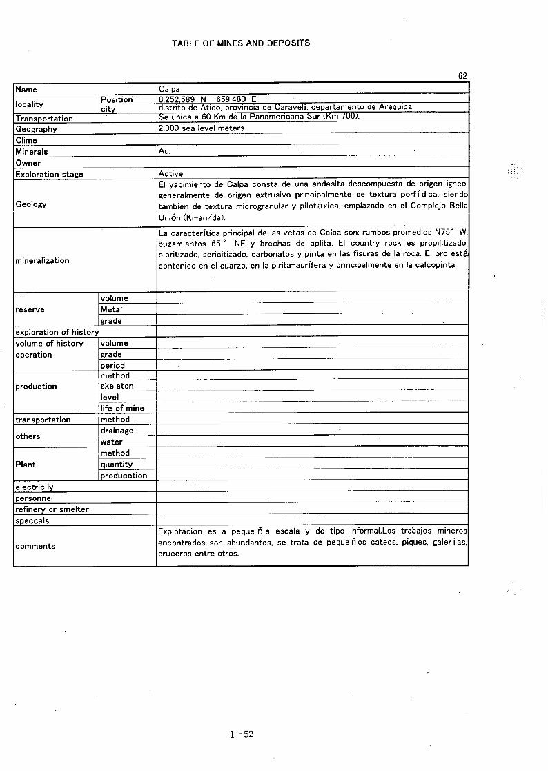
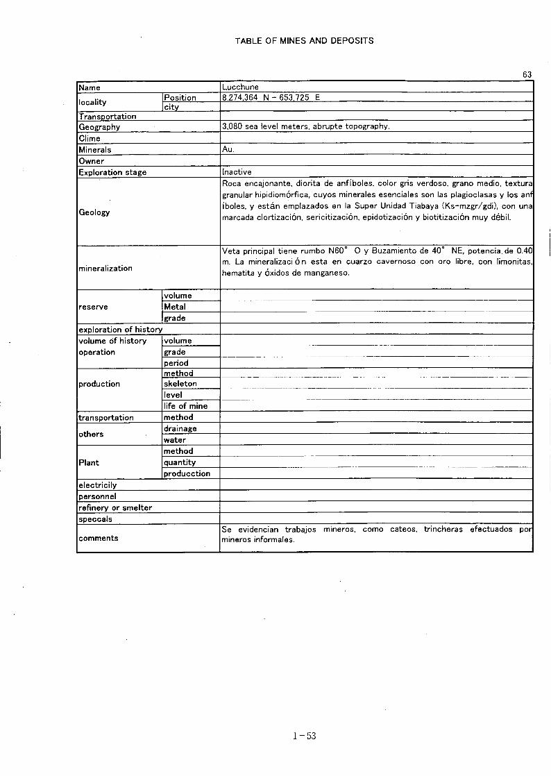
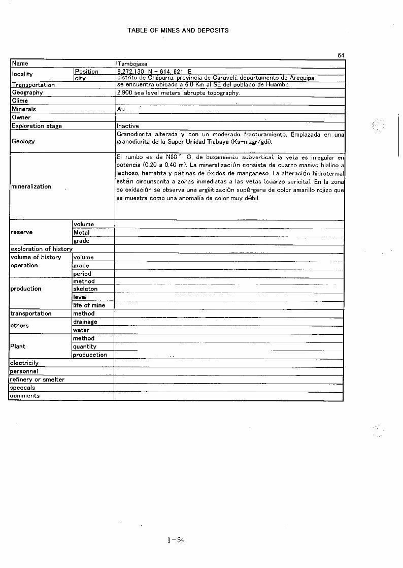
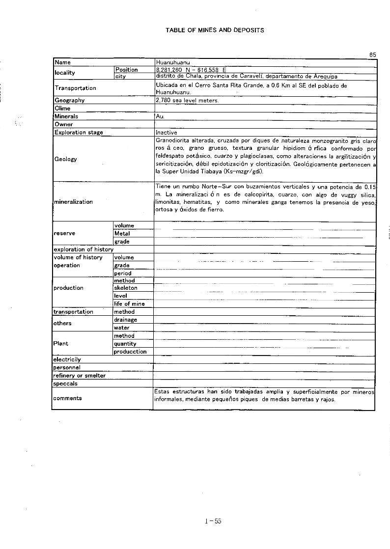
1. Calhuahuacho district (Fig.2, Fig.3)
The skarn type and hydrothermal strata-bound copper (and iron) deposits such as Ferrobamba,Chalcobamba, Sulfobamaba, Charcas are located in the north of the district. Result of imageanalysis showed that the area has a high potential for hydrothermal deposit as the lineamentdensity is high suitable for circulation of hydrothermal solution and the anomaly of the ironoxide index is located around the intrusives.The field survey has been conducted in three areas, and 12 samples were collected. As the resultof assay and field survey, it was concluded that the area is no longer interested. However,although the geological setting of the area is not clear, assay result of two samples shows highAs and Pb (100 times of the Clark Number) and Au is in the order of 100 ppb. Therefore, thecharacter and occurrence of the samples are to be studied prior to the final conclusion.Table 2 shows comparison of the selected area and the area of field survey carried out byINGEMMET. The area of field survey covers only 15% of the selected area. Therefore, it is toohasty to evaluate the whole area by the result of survey. On the southeast of the survey area 3,an anomaly of the iron oxide index in the Tertiary intrusives has been detected, a field surveyincluding this area is necessary.
2. Livitaca district (Fig.4)
The district was thought to has a high potential for existence of skarn type and/or vein typedeposits, as there are skarn type Fe deposit (Livitaca), Cu-Pb-Zn deposit (Lomas de Oro), high
- 2-1 -
lineament density and concentration of anomalies of iron oxide index around Tertiary intrusives.The field survey has been conducted in two area, the one is located within the selected districtand the other is located in outside of the selected district on the west adjacent to the above area .Four samples were collected and assayed in the area within the selected district. As a result theconclusion was negative. In the area outside of the district 14 samples were collected andassayed. As a result anomaly of rock geochemistry, of which Au, Ag, As, Ba, Pb, Zn assay are100 times of the Clarke number, was detected. It is concluded that the ANAD procedure (toprohibit application of mineral claim is to be taken and then a detailed field survey is to beconducted.As the area of field survey covers only 10% of the selected area, it is difficult to evaluate thewhole area. Occurrence of an iron oxide index anomaly in Tertiary intrusives has been known inthe survey area 4, and geochemical anomaly was found in the same area. The combination ofacidic intrusive rock and iron oxide anomaly is seems to be important in selecting a promisingarea.
3. Macusani district (Fig.5, Fig.6)
Occurrence of vein type deposit (San Rafael, Quenamari, etc.) and manto type deposit (Cerrodel Inca Nro. 28) in and around Tertiary intrusives is known. As the iron oxide index anomalytend to be concentrated around the intrusives and lineament density is also high, it was indicatedthat the iron oxide index anomaly is probably indicating the existence of mineralized alterationzone.The field survey has been conducted in three areas and 11 samples were collected and assayed.As a result it was concluded that none of the area need further investigation.However, although the geological setting of the area is not clear, assay result shows threesamples from two area are high in As and Pb corresponding to 100 times of the Clarke number,therefore the character and occurrence of the samples are to be studied prior to the finalconclusion.As the area of field survey covers only 6.36% the Macusani district, it is difficult to evaluate thedistrict from the survey result. Especially in and around Tertiary intrusives where the San Rafaeldeposit occur, is not included in the survey area probably due to the mineral claim. The mostimportant area has not been surveyed yet.
4. Usicayos district (Fig.7, Fig.8)
The district is located to the northeast of the Macusani district. A number of mineral showings
- 2-2 -
including polymetallic dissemination type deposit (Sarita) occur in the area. The area wasselected to a promising district as the lineament density is somewhat higher and there is aconcentration of iron oxide index anomalies in Carboniferous to Permian sediments.The field survey has been conducted in four areas and 15 samples were collected and assayed.As the result, it was concluded that none of the area needs further investigation.However, although the geological setting of the area is not clear, assay result of two samplesshowed high in As and Cu corresponding to 100 times of the Clarke number. Therefore thecharacter and occurrence of the samples are to be studied prior to final conclusion.Although it is difficult to evaluate the district from the survey result as the survey area coversonly 23.6% of the Usicayos district, the iron oxide index anomaly in this district may not alwaysindicate the presence of mineralization, since no geochemical anomaly was detected in thesurvey area, where iron oxide index anomalies were concentrated.
5. Vilque district (Fig.9, Fig.10)
The area was selected as a promising district due to that the occurrence of known mineralshowings are concentrated around Tertiary intrusives where iron oxide index anomalies are alsoconcentrated, and lineament density is slightly higher.The field survey has been conducted in two areas and nine samples were collected and assayed.It was concluded that no further investigation is required in both areas.Assay result of one sample shows high in As and Bi correspond to 100 times of the Clarkenumber and assay result of 17 ppb of Au was also obtained. Since there is a description of thepresence of a small vein and small mine site in the area where the above samples were collected,a relationship to the above sample is to be studied.Although it is difficult to evaluate this district from the survey result as the survey area coversonly 10.59% of the Vilque district, the iron oxide index anomaly in this district may not alwaysindicate the presence of mineralization, since none of geochemical anomaly was detected in thesurvey area 14 where iron oxide index anomalies were concentrated.
6. Consideration
Based on the result of last years survey and analysis, the field survey including rockgeochemical survey has been conducted in 16 areas in five district and total of 65 rock sampleswere collected assayed. As the result, it was concluded that further detailed survey is not worthto be conducted in 15 areas among them.In regard to the rock geochemical survey the assay result of a few samples shows an order of
- 2-3 -
100 times of the Clarke number. The meaning of such high assay value is to be clarified namelyan overall analysis on the assay value of each rock type, rock alteration, mode of occurrence ofthe sample and mineralized alteration of surrounding area, etc. is to be conducted.As shown in the Table 2, the area of survey covers only 11.69% of the total promising area, it isdifficult to evaluate every district from the survey result. Especially in the southeast of surveyarea 3 in the Calhuahuacho district and in the Macusani district a reconnaissance field survey isto be conducted in and around Tertiary intrusives where iron oxide index anomalies have beendetected.
- 2-4 -