Embed Size (px)
Citation preview

Georges River DCP 2021 – Part 3 General Planning Considerations – October 2021 1
Part 3 General Planning Considerations
Contents 3.1 Introduction ............................................................................................................. 3
3.2 Biodiversity ............................................................................................................. 3
3.2.1 Trees & Vegetation .......................................................................................... 3
3.2.2 Green Web ...................................................................................................... 4
3.3 Landscaping ........................................................................................................... 6
3.4 Bushfire Prone Land ............................................................................................... 7
3.5 Earthworks .............................................................................................................. 9
3.5.1 Excavation (including cut and fill) ..................................................................... 9
3.5.2 Construction Management / Erosion and Sediment Control ........................... 10
3.6 Contaminated Land ............................................................................................... 11
3.7 Heritage ................................................................................................................ 12
3.7.1 Aboriginal Cultural Heritage ........................................................................... 12
3.7.2 Non-Aboriginal Heritage ................................................................................. 12
3.7.3 Archaeological Management .......................................................................... 13
3.7.4 Heritage Items - Site Specific Requirements .................................................. 14
3.7.5 Heritage Conservation Areas ......................................................................... 14
3.7.6 Development in the vicinity of a Heritage Item or Heritage Conservation Area15
3.8 Views Impacts ....................................................................................................... 15
3.9 Coastal Hazards and Risks ................................................................................... 16
3.9.1 Coastal Management ..................................................................................... 16
3.9.2 Sea Level Rise ............................................................................................... 16
3.10 Water Management .............................................................................................. 18
3.11 Ecologically Sustainable Development .................................................................. 20
3.11.1 Energy and Water Efficiency .......................................................................... 20
3.12 Waste Management .............................................................................................. 22
3.13 Parking Access and Transport .............................................................................. 23
3.14 Utilities .................................................................................................................. 37
3.15 Public Domain ....................................................................................................... 38
3.15.1 Infrastructure.................................................................................................. 38
3.15.2 Public Art ....................................................................................................... 38
3.16 Subdivision ........................................................................................................... 40
3.16.1 Lot Size and Shape........................................................................................ 40
3.16.2 Roads, Vehicular Access and Car Parking ..................................................... 41
Georges River DCP 2021 – Part 3 General Planning Considerations – October 2021 2
3.16.3 Utilities and Services ...................................................................................... 41
3.16.4 Drainage ........................................................................................................ 42
3.17 Universal / Accessible Design ............................................................................... 43
3.18 Advertising and Signage ....................................................................................... 45
3.19 Crime Prevention / Safety and Security ................................................................. 49
3.20 Noise and Vibration ............................................................................................... 51
3.20.1 Aircraft Noise and OLS .................................................................................. 51
3.20.2 Development near Road and Rail Corridors ................................................... 51
3.20.3 Noise Generating Development ..................................................................... 52

Georges River DCP 2021 – Part 3 General Planning Considerations – October 2021 3
3.1 Introduction This part contains objectives and design controls for the protection of the environment and
applies to all forms of development.
Note: Where reference is made to a published Australian/New Zealand Standard, it is the
most recent version.
3.2 Biodiversity
3.2.1 Trees & Vegetation
Objectives
(a) Ensure the protection of existing trees which contribute to the visual amenity and
environment of the LGA.
(b) Protect trees within and adjacent to all development sites.
(c) Maximise healthy tree canopy coverage across the LGA, so as to maximise reduction
in the urban heat island effect.
(d) Identify responsibilities and requirements with respect to the protection, retention and
replacement of trees.
(e) Provide processes which enable and facilitate citizen compliance with these
provisions.
(f) Ensure all applications for tree removal and pruning are assessed on the basis of the
best practice tree management principles.
Controls
1. Development is to comply with the provisions of the State Environmental Planning
Policy (Vegetation in Non-Rural Areas) 2017.
2. Development is to comply with the provisions of the Biodiversity Conservation Act
2016 and the Biodiversity Regulation 2017.
3. Development is to comply with Council’s Tree Management Policy and Appendix 1 –
Green Web Map and Biodiversity Guide on Council’s website.

Georges River DCP 2021 – Part 3 General Planning Considerations – October 2021 4
3.2.2 Green Web
Introduction
The Green Web seeks to conserve and enhance Georges River’s bushland and biodiversity
by identifying and appropriately managing key areas of bushland habitat and establishing
and maintaining interconnecting linkages and corridors.
The Green Web is mapped to include:
• Habitat Corridor
• Habitat Reinforcement Corridor
The objectives and controls in this chapter will affect the siting of development on parcels of
land; determine what vegetation is retained and how the proposed landscape elements are
integrated with new development.
Objectives
(a) Prevent direct loss of habitat in and adjoining Green Web areas and enhance long
term sustainability.
(b) Prevent fragmentation of bushland.
(c) Enhance biodiversity and ensure ecological resilience through greater connectivity of
bushland areas.
(d) Improve the function of riparian zones and foreshores to provide linkages and corridors
between areas of habitat.
(e) Minimise weed invasion and spread within Green Web areas.
(f) Revegetate habitat or corridors to compensate for detrimental impacts accruing from
the development of land.
(g) Enhance vegetation corridors in urban areas
(h) Re-establish corridors in urban areas.
Controls
All Green Web Areas
1. Green Web areas are those areas mapped on the maps contained within Appendix 1.
2. Green Web areas are to be landscaped with species indigenous to the Georges River
Council area, listed in Council’s Backyard Biodiversity Guide on Council’s website and
Council’s Tree Management Policy (and its Appendix 1 – Tree Planting). Trees and
landscaping should be provided in a form and configuration that maintains and
enhances the core habitat and vegetated linkages.

Georges River DCP 2021 – Part 3 General Planning Considerations – October 2021 5
3. Development should contribute to the maintenance of local habitats and connectivity
between bushland remnants.
4. Development should seek to retain unique environmental features of the site including:
i. Rock outcrops;
ii. Wetlands and the like;
iii. Watercourses, drainage lines and riparian land;
iv. Groups of significant trees and vegetation; and
v. Mature trees with hollows and other fauna habitat features on the site.
5. Bushfire asset protection zones must not be in identified area of key habitat and
corridors, except in the case of development or redevelopment of single dwellings and
secondary dwellings on existing lots or alterations and additions to existing dwellings.
6. Development should ensure that off-site impacts into adjoining bushland are
minimised, such as weed invasion, increased runoff and stormwater pollutants.
Controls for Green Web Habitat Corridor Areas
7. Development should maintain habitats in a size and configuration that ensures their
ongoing viability and sustainability.
8. Development should ensure connectivity between bushland remnants. To achieve this,
corridors should be of a scale commensurate with the habitats they connect.
Controls for Green Web Habitat Reinforcement Corridor Areas
9. Development should, through its siting, design and landscape treatment, maximise
habitat values and minimise disruption to connectivity through:
i. Allocating one boundary of the site to planting of indigenous vegetation of a mix
of canopy species (over 3m height at maturity) and understorey species (less
than 3m height at maturity, or
ii. Retention and revegetation of remnant bushland elements.
10. The required treatment will depend upon the scale of the bushland remnants linked by
the land or the quality of the remnants to be retained on site.
Note:
No Green web mapping was previously undertaken for the former Hurstville LGA. As such
additional mapping will be required for the entire Georges River LGA.

Georges River DCP 2021 – Part 3 General Planning Considerations – October 2021 6
3.3 Landscaping Objectives
(a) Contribute to the creation of a distinct landscape character for the Georges River LGA.
(b) Protect existing significant trees and vegetation as outlined in Council’s Tree
Management Policy.
(c) Reduce the visual and environmental impact of buildings, structures and hardstand.
(d) Create attractive, comfortable, functional and safe streets, public domain and private
domain.
(e) Complement and enhance the function of communal open space, private open space
and setback areas.
(f) Provide potential habitat for local wildlife species.
(g) Encourage on site stormwater infiltration.
(h) Reduce the urban heat island effect.
Controls
1. Landscaping on site should be incorporated into the site planning of a development to
(where appropriate):
i. Reinforce the desired future character of the locality;
ii. Maintain significant landscape features;
iii. Be consistent with any dominant species in the adjoining area of ecological
significance;
iv. Incorporate fire resistant species in areas susceptible to bushfire hazard;
v. Provide planting within setback zones (setbacks identified within the relevant
applicable parts of the DCP);
vi. Soften the visual impact of buildings, carparks and roads;
vii. Cater for outdoor recreation areas;
viii. Separate conflicting uses;
ix. Screen undesirable elements;
x. Provide opportunities for on-site stormwater infiltration, in particular around
existing trees and vegetation;
xi. Consider the future maintenance requirements of landscaped areas;
xii. Protect the effective functioning of overhead, surface level or underground
utilities; and
xiii. Improve the aesthetic quality of the development.

Georges River DCP 2021 – Part 3 General Planning Considerations – October 2021 7
2. Landscape planting should achieve a mature height in scale with the structures on the
site.
3. Where canopy trees, shrubs and groundcovers are required, preference should be
given to incorporating locally indigenous plants listed in GRDCP 2021 Backyard
Biodiversity Guide on Council’s website and Council’s Tree Management Policy (and
its Appendix 1 – Tree Planting).
4. Hydrological issues should be considered at the early stages of design for
development around and close to trees on development sites.
5. Public domain works including street tree planting should comply with Council’s
relevant policies including:
i. Kogarah North Public Domain Plan
ii. Kogarah Street Tree Management Strategy and Masterplan 2009;
iii. Hurstville Street Tree Management Study 2015; and
iv. Georges River Public Domain Streetscape works specifications 2019.
6. Topsoil and mulch should be included in landscape areas and should contain organic
matter to support plant growth.
Planting on Structures
7. Where landscaping is provided in a structured environment such as a raised planter
box or ‘on slab’ they should include waterproofing, drainage and automatic irrigation.
The minimum plant material pot container sizes for trees should be 75 litres and
minimum soil depth for shrubs 200mm and groundcovers 150mm.
8. Green roofs and walls must be provided in higher density urban environments where
opportunities for deep soil landscaping are limited and/or where large walls face active
areas of the public domain.
Note: Trees rely on natural seepage for survival and placement of structures, dwellings etc.
can impede these flows and adversely impact tree health.
3.4 Bushfire Prone Land Objectives
(a) Locate and design development to minimise the risk to life and property from
bushfires.
(b) Balance the conservation of native vegetation and bushfire protection.
Georges River DCP 2021 – Part 3 General Planning Considerations – October 2021 8
Controls
1. Development should be located and designed to minimise the need for bushfire hazard
reduction within native vegetation areas.
2. Bushfire Asset Protection Zones should be located entirely within the development
site.
Note: Development on land identified as bushfire prone on Council’s Bushfire Prone Land
Map should address the bush fire protection measures in the publication Planning for
Bushfire Protection (2019).
Georges River DCP 2021 – Part 3 General Planning Considerations – October 2021 9
3.5 Earthworks
3.5.1 Excavation (including cut and fill)
Objectives
(a) Ensure that the natural topography and landform is maintained, and the amount of
excavation is minimised.
(b) Minimise the visual impact of new development, particularly when viewed from the
public domain.
(c) Minimise earthworks to maintain the existing landform and protect the integrity and
stability of geological elements in the vicinity of the site.
(d) Minimise impacts on surrounding vegetation and provide increased opportunities for
tree retention, including trees on neighbouring properties.
(e) Ensure earthworks do not detrimentally impact on stormwater flows or flood conditions
on adjacent land.
Controls
1. Natural ground level should be maintained within 900mm of a side and rear boundary.
2. Cut and fill should not alter natural or existing ground levels by more than 1m (see
Figure 1).
3. Habitable rooms (not including bathrooms, laundries and storerooms) are to be located
above existing ground level.
4. Rock outcrops, overhangs, boulders, sandstone platforms or sandstone retaining walls
are not to be removed or covered.
5. Development is to be located so that clearing of vegetation is avoided.
6. Cut and fill within a tree protection zone (TPZ) of a tree on the development site or
adjoining land, must be undertaken in accordance with Australian Standard AS 4970
(Protection of trees on development sites).
7. Soil depth around buildings should be capable of sustaining trees as well as shrubs
and smaller scale gardens.
8. Earthworks are not to increase or concentrate overland stormwater flow or aggravating
existing flood conditions, on adjacent land.
9. Fill material must be virgin excavated natural material (VENM) or fill that meets all of
the conditions of a recourse recovery order issued by the NSW Environmental
Protection Authority (EPA).
10. For sites identified as flood affected, any cut and fill works, included in the
development are to comply with the requirements of Council’s Stormwater
Management Policy, specifically Chapter 6 – Flooding and Overland Flow.

Georges River DCP 2021 – Part 3 General Planning Considerations – October 2021 10
Figure 1: Maximum Cut and Fill
3.5.2 Construction Management / Erosion and Sediment Control
Objectives
(a) Protect the environmental quality of waterways.
(b) Reduce erosion hazard and prevent soil, building material and pollutants leaving the
site and entering waterways.
(c) Prevent reduction in the hydraulic capacity of drainage systems.
(d) Enable the community to reuse, repair, recycle or dispose of waste at safe, clean and
easily accessible facilities.
Controls
1. Development must minimise any soil loss from the site to reduce impacts of
sedimentation on waterways through the use of the following:
• Sediment fencing
• Water diversion
• Single entry / exit points
• Filtration materials such as straw bales and turf strips
Refer to NSW Guidelines for Erosion and Sediment Control on Building Sites for
further guidance.
2. Development that involves site disturbance is to provide an erosion and sediment
control plan which details the proposed method of soil management and its
implementation. Such details are to be in accordance with The Blue Book – Managing
Urban Stormwater: Soils & Construction by Landcom.
3. Development is to minimise site disturbance, including impacts on vegetation and
significant trees and the need for cut and fill.

Georges River DCP 2021 – Part 3 General Planning Considerations – October 2021 11
4. Construction works within a tree protection zone (TPZ) of a tree on the development
site or adjoining land, must be undertaken in accordance with AS 4970 (Protection of
trees on development sites).
5. Development which has high potential risk to groundwater must submit a geotechnical
report to address how possible impacts on groundwater are minimised.
6. Work must not be carried out in a public road or footpath unless a permit has been
granted by Council (or other relevant roads authority) under s.138 of the Roads Act
1993, and / or s.68 of the Local Government Act 1993. These are separate approvals
to development consent or a Complying Development Certificate. Consult with Council
to determine if a permit is required.
3.6 Contaminated Land Objectives
(a) Ensure that the development of contaminated or potentially contaminated land does not pose a risk to human health or the environment
Controls
1. Each development application is to include information sufficient to allow Council to
meet its obligation to determine whether development should be restricted due to the
presence of contamination.
2. Proposals for the development of contaminated land or potentially contaminated land
will need to determine:
i. The extent to which land is contaminated (including both soil and groundwater
contamination);
ii. Whether the land is suitable in its contaminated state (or will be suitable after
remediation) for the purpose for which the development is proposed to be carried
out;
iii. Whether the land requires remediation to make the land suitable for the intended
use prior to that development being carried out; and
iv. If the land has been previously investigated or remediated, development cannot
be carried out until Council has considered the nature, distribution and levels of
residues remaining on the land and Council has determined that the land is
suitable for the intended use.
3. Operating practices and technology must be employed to prevent contamination of
groundwater.
Note: For requirements related to Contaminated Land, refer to State Environmental Planning
Policy No.55 – Remediation of Land (SEPP 55) and the Managing Land Contamination:
Planning Guidelines.

Georges River DCP 2021 – Part 3 General Planning Considerations – October 2021 12
3.7 Heritage Notes:
Any application for a property identified in the Georges River LEP 2021 as a heritage item or
in the vicinity of a heritage item or heritage conservation area, must be accompanied by a
Heritage impact statement. Refer to Council’s Development Application Guide for further
details.
A Conservation Management Plan (CMP) may be required for works relating to State
heritage items subject to advice from Council’s Heritage advisory service.
3.7.1 Aboriginal Cultural Heritage
Objectives
(a) Acknowledge the importance of Aboriginal heritage as part of Georges River heritage
resources.
(b) Protect Aboriginal objects and Aboriginal Places of heritage significance by minimising
the likelihood of disturbance from development.
(c) Minimise potential for interference with archaeological objects as a result of
development by encouraging relics to be preserved in-situ.
(d) Minimise disturbance and exposure of areas along the foreshore including excavations
for swimming pools, jetties, and boat sheds.
(e) Minimise disturbance to rock outcrops and overhangs.
Controls
1. Obtain relevant approvals from other agencies prior to commencing work where a site
contains, or has potential for Aboriginal objects.
2. Building and landscaping works, including paths and driveways are not to disturb any
Aboriginal objects.
3. New works including excavations for swimming pools, jetties and boat sheds is to be
sited away from the foreshore where possible.
4. New works are to be sited away from rock outcrops and overhangs.
3.7.2 Non-Aboriginal Heritage Objectives
(a) Ensure changes to heritage items are based on an understanding of the heritage
significance of the heritage item.

Georges River DCP 2021 – Part 3 General Planning Considerations – October 2021 13
(b) Allow change to occur to heritage items to meet amenity and contemporary safety,
sustainability or technological standards, provided that those changes are sympathetic
to and does not detrimentally affect the heritage significance of the heritage item.
(c) Ensure significance features of heritage items are retained and that development is
sympathetic to these features with particular regard to bulk, form, style, character,
scale, setbacks and materials.
(d) Acknowledge changes over time to heritage items, as subsequent layers may also be
of significance.
(e) Encourage reinstatement of missing details and the removal of past unsympathetic
changes, to improve overall outcomes to the heritage significance of the heritage item.
(f) Allow changes to the rear of heritage items where the new work does not impact the
heritage significance of the item.
(g) Ensure that new uses of heritage items are compatible with the fabric and heritage
significance of the item.
(h) Encourage changes to be reversible where possible and appropriate.
Controls
1. Retain features (including landscape features) that contribute to the significance of the
item.
2. Remove unsympathetic elements, especially where substantial changes are proposed
to a heritage item, and there is potential for an improved heritage outcome.
3. New work is to be consistent with the setback, massing, form and scale of the
significant features of the heritage item.
4. Retain significant fabric, features or parts of the heritage item that represent key
periods of the item’s history or development.
5. Locate change away from original areas of the heritage item that are intact. For
example, where a building’s significance is related to the front of a building, locate new
work to the rear.
6. All works are to be consistent with an adopted Conservation Management Plan/s
where applicable.
3.7.3 Archaeological Management Objectives
(a) Acknowledge the importance of archaeology as part of the Georges River heritage.
(b) Minimise potential for interference with archaeological heritage as a result of
development by encouraging relics to be preserve in-situ.
Georges River DCP 2021 – Part 3 General Planning Considerations – October 2021 14
Controls
1. Minimise the depth and extent of any excavation and locate new work away from
areas known to contain archaeological relics.
2. Ensure reversibility of changes (as relevant).
3.7.4 Heritage Items - Site Specific Requirements Note: The following site-specific requirements including diagrams are provided separately in
Appendix 2.
• No. 24 Penshurst Avenue, Penshurst
• No. 211-217 Rocky Point Road, Ramsgate
3.7.5 Heritage Conservation Areas Objectives
(a) Provide guidelines and controls which seek to protect the significant character of
Georges River Heritage Conservation Areas and which encourage design which
responds appropriately to the streetscape character.
(b) New development and / or alterations and additions in Heritage Conservation Areas
must respect the architectural character and complement and enhance the
significance of conservation areas and their settings.
(c) Existing dwellings in the Heritage Conservation Areas are to be retained.
(d) New dwellings in Heritage Conservation Areas must respect the architectural character
and complement and enhance the significance of conservation areas and their
settings.
Controls
1. Any development in the Heritage Conservation Areas is to address and respond to the
requirements of the relevant Heritage Conservation Area Guidelines contained in
Appendix 3.
2. New development must demonstrate how it respects the heritage values of the
Heritage Conservation Area (as detailed in the Heritage Conservation Area
guidelines).
3. Demolition of dwellings in the Heritage Conservation Areas identified as Contributory
or Neutral will generally not be supported, unless a structural assessment has been
undertaken by a suitably qualified professional and a report is submitted to Council
confirming that the building is structurally unsound.

Georges River DCP 2021 – Part 3 General Planning Considerations – October 2021 15
3.7.6 Development in the vicinity of a Heritage Item or Heritage
Conservation Area
Objectives
(a) Ensure development in the vicinity of a heritage item or heritage conservation area is
designed and sited to protect the heritage significance of the item or heritage
conservation area.
Controls
1. Respect and respond to the curtilage, setbacks, form, scale and style of the heritage
item or heritage conservation area in the design and siting of new work.
2. Maintain significant public domain views to and from the heritage item or heritage
conservation area.
3. Ensure compatibility with the orientation and alignment of the heritage item.
4. Provide an adequate area around the heritage item to allow for its interpretation.
5. Retain original or significant landscape features that are associated with the heritage
item or that contribute to its setting.
6. Protect and allow interpretation of archaeological features as appropriate.
Note: The following conservation areas guidelines are provided in Appendix 3.
• Penshurst Heritage Conservation Area
• Kogarah South Heritage Conservation Area
• O’Brien’s Estate Heritage Conservation Area
3.8 Views Impacts Objectives
(a) Protect vistas and public views from streets and public places.
(b) Ensure views to and from the site are considered at the site analysis stage.
(c) Recognise the value of views from private dwellings and encourage view sharing
based on the Tenacity Planning Principle.
(d) Recognise the value of view sharing whilst not restricting the reasonable development
potential of the site.

Georges River DCP 2021 – Part 3 General Planning Considerations – October 2021 16
Controls
1. Development shall provide for the reasonable sharing of views.
Note: Where a proposal is likely to adversely affect views from either private or public land,
assessment of applications will refer to the Planning Principle established by the Land and
Environment Court in Tenacity Consulting vs Warringah Council (2004) NSWLEC140. The
Planning Principle is available to view on the Land and Environment Court’s website at
www.lawlink.nsw.gov.au/lec
3.9 Coastal Hazards and Risks
3.9.1 Coastal Management
Objective
(a) Protect and manage the coastal environment of the LGA.
Control
1. Development is to comply with the provisions of the State Environmental Planning
Policy (Coastal Management) 2018 and the Coastal Management Act 2016.
3.9.2 Sea Level Rise
Objectives
(a) Ensure that development adequately considers and responds to sea level rise
projections, and the predicted effects on inundation, flooding, coastal and foreshore
recession, and on groundwater levels.
(b) Ensure that development on land vulnerable to sea level rise is situated and designed
to minimise the risk from future inundation, flooding, coastal and foreshore recession,
and from rises in groundwater levels during the expected life of the development.
(c) Ensure that development is designed to enable future adaptation if projections are
realised, or that measures are implemented to mitigate any adverse impacts of climate
change or sea level rise.
Controls
1. Development on land identified on the Georges River LEP 2021 ‘Coastal Hazard and
Risk Map’ must implement measures to mitigate the adverse effects of projected sea
level rise and increases in flood levels on the development.
2. Development should be designed and situated to reduce the risk from the effects of
sea level rise. For example, structures should be located on the highest part of the Lot

Georges River DCP 2021 – Part 3 General Planning Considerations – October 2021 17
and/ or located on the lot away from the foreshore or coastline while still satisfying
other controls and objectives of the DCP.
3. Development on land adjacent to tidal waters, including the Georges River and Salt
Pan Creek, should be designed to minimise the risk to property and the environment
from sea level rise in the event of a 1% AEP flood by:
i. Siting the floor level of habitable rooms, wet areas and other sensitive uses (e.g.
on-site wastewater disposal areas) 1.4m above the 1% AEP riverine flood level.
The 1.4m is to allow for the 2100 (year) NSW sea level rise planning benchmark
of 0.9m and 0.5m freeboard.
ii. Siting other non-habitable structures (e.g. sheds, decks, pergolas) 0.7m above
the 1% AEP riverine flood level. The 0.7m is to allow for the 2050 (year) NSW
sea level rise planning benchmark of 0.4m and 0.3m freeboard.
iii. Siting all garages and basements 1.2m above the 1% AEP riverine flood level.
The 1.2m is to allow for the 2100 (year) NSW sea level rise planning benchmark
of 0.9m including 0.3m freeboard.
Notes:
For best practice guidelines refer to:
i. NSW Floodplain Development Manual (2005),
ii. NSW Coastal Planning Guideline: Adapting to Sea Level Rise (2010),
iii. Flood Risk Management Guide – Incorporating sea level rise benchmarks in
flood assessments (2010), and
iv. Australian Rainfall and Runoff: A Guide to Flood Estimation
* AEP (measured as a percentage) is a term used to describe flood size. It is a means
of describing how likely a flood is to occur in a given year. For example, a 1% AEP
flood is a flood that has a 1% chance of occurring or being exceeded, in any one year.
* A Section 10.7 Planning Certificate will identify whether or not the site is subject to
exposure to tidal inundation and/ or flood hazard risk.
* In cases where land is also affected by overland flooding, the appropriate flood levels
will be the higher of the required floor levels as determined necessary due to overland
flooding and those determined through the application of Section 3.9 - Coastal
Hazards and Risks of the DCP.
Georges River DCP 2021 – Part 3 General Planning Considerations – October 2021 18
3.10 Water Management Objectives
(a) Ensure development has minimal impacts on the natural water cycle and the
environment, including natural water systems, water quality and surface / ground water
flow regimes.
(b) Ensure development has minimal impacts on Council’s existing drainage network.
(c) Minimise run-off volumes and discharge rates to ensure no ‘net’ increase in
stormwater drainage flows and flood risk in urban areas relative to the existing.
(d) Ensure the safety of people in flood risk areas and limit the potential damage to
property and infrastructure.
(e) Manage continuing flood risk and cumulative impacts of developments.
(f) Reduce the development’s reliance on mains supplied water and encourage more
efficient use of water.
(g) Encourage water conservation and reuse through the provision of water reuse
facilities, conservation practices, recycling and groundwater recharge.
(h) Minimise pollution from the development during and after construction.
(i) Minimise public drainage infrastructure costs.
Controls
Stormwater Management
1. Development must comply with Council’s Stormwater Management Policy 2020 which
provides detail of drainage requirements for different development types. Consultation
with Council is recommended.
2. Water Sensitive Urban Design (WSUD) principles are to be incorporated into the
design of stormwater drainage, on-site retention and detention, landscaping and within
the overall design of the development.
Flood Risk Management
3. Development must comply with the Flooding and Overland Flow Section of Council’s
Stormwater Management Policy which provides guidelines of controlling developments
in different flood risk areas. It should be read in conjunction with the NSW
Government’s ‘Floodplain Development Manual 2005’.
4. Flood risk areas are identified as follows:
i. Flood Planning Area has the same meaning as it has in the Floodplain
Development Manual.

Georges River DCP 2021 – Part 3 General Planning Considerations – October 2021 19
ii. 1% AEP flood event affected areas in Council’s adopted Overland Flow Flood
Studies. Refer to Council’s website www.georgesriver.nsw.gov.au, specifically
the Flood Management section.
iii. Probable maximum flood (PMF) affected areas in Council’s adopted Overland
Flow Flood Studies. Refer to Council’s website www.georgesriver.nsw.gov.au,
especially the Flood Management section.
5. Development consisting of sensitive land uses should not be undertaken in PMF
affected areas. In the case that such a development is permitted, the floor levels must
be set at 1% AEP floor level plus 500 mm freeboard or the PMF, whichever is the
greater. Sensitive land uses, in terms of flood consideration, means development for
the following purposes:
1. boarding houses,
2. caravan parks,
3. correctional centres,
4. early education and care facilities,
5. eco-tourist facilities,
6. educational establishments,
7. emergency services facilities,
8. group homes,
9. hazardous industries,
10. hazardous storage establishments,
11. hospitals,
12. hostels,
13. information and education facilities,
14. respite day care centres,
15. seniors housing,
16. sewerage systems,
17. tourist and visitor accommodation,
18. water supply systems.
Notes:
Refer to Council’s Stormwater Management Policy 2020, specifically Section 6 Flooding and
Overland Flow for further guidance.
Water Quality
6. Measures to control pollutants in stormwater discharge from development sites are to
be included in any development. Refer to Section 3.5.2 – Construction Management /
Erosion and Sediment Control of this DCP.
7. Runoff entering directly to waterways or bushland is to be treated to reduce erosion
and sedimentation, nutrient and seed dispersal.

Georges River DCP 2021 – Part 3 General Planning Considerations – October 2021 20
3.11 Ecologically Sustainable Development
3.11.1 Energy and Water Efficiency
Objectives
(a) Ensure development incorporates environmentally sustainable design and
construction.
(b) Reduce the impacts of development on the environment.
(c) Reduce the cause and impacts of the urban heat island effect.
(d) Increase the resilience of development to the effects of climate change.
(e) Ensure that greenhouse gas emissions will be reduced.
(f) Reduce the use of potable water.
(g) Ensure that development can adapt to climate change.
(h) Reduce the environmental impact from building materials through reduction, re-use
and recycling of materials, resources and building components.
Controls
Residential Buildings
1. All BASIX affected development must comply with SEPP (Building Sustainability Index:
BASIX) 2004.
Non BASIX Residential Buildings
2. Additional or replacement ceiling/roof and walls must be fitted with insulation.
Ceiling/roof insulation must be rated R3.0 or equivalent and wall insulation must have
an R1.5 or equivalent rating. Insulation of cavity brick walls is not required.
3. Any hot water system(s) installed as part of a development or as a replacement must
consider the most efficient option available to minimise greenhouse gas emissions.
4. Water Efficient Fixtures: where new or replacement fittings are required shower heads
shall be at least 3 star rated water efficient 4 star dual flush toilets and 4 star taps (for
all taps other than bath outlets and garden taps), bathroom and kitchen taps shall be
fitted with aerators; and water closets shall have a dual flush cistern.
5. Any products installed as part of a development or as a replacement that are regulated
for water efficiency under Water Efficiency Labelling and Standards (WELS) Scheme
must obtain a Minimum WELS rating of 4.5 stars. Products that carry a star water label
and are regulated under WELS include clothes washing machines and dishwashers.
The water star rating as well as date of purchase of the product should be visible on
the product at all times. The Federal Governments WELS website has a

Georges River DCP 2021 – Part 3 General Planning Considerations – October 2021 21
comprehensive list of efficient appliances based on star ratings available at
www.waterrating.gov.au.
6. Wherever practicable, orient the development to reduce the need for artificial lighting
by maximising daylight in habitable areas, whilst minimising heat and glare. Ways to
achieve this includes skylights, atriums or light shafts and adjustable shading.
Non-Residential Buildings
7. Development must comply with Clause 6.10 Design Excellence of Georges River LEP
2021.
8. All development must comply with Section J Energy Efficiency of the BCA/NCC.
9. The energy efficiency provisions of the Building Code of Australia should be
incorporated into the design of non-residential buildings. This may require the inclusion
of the following:
i. Windows that are appropriately sized and shaded to reduce summer heat load
and permit entry of winter sun.
ii. Building materials selected to assist thermal performance and ceiling insulation
used where appropriate.
iii. Natural ventilation.
iv. Buildings should have an area, orientation and roof pitch that is suitable for the
installation of solar collectors.
v. Low energy, high efficiency plant, fittings and appliances should be specified.
vi. The use of photovoltaic panels/solar collectors for hot water heating and power is
encouraged to reduce energy consumption.
10. Water conservation principles should be incorporated into non-residential
developments, including the following:
i. Water efficient fittings and appliances including: 4 star dual-flush toilets and taps,
3 star showerheads and urinals, water efficient washing machines and
dishwashers.
ii. Rainwater tanks should be provided to meet 80% of non-potable demand
including outdoor use, toilets and laundry.
iii. Cooling Towers are designed in accordance with best practice guidelines to
reduce potable water consumption.
iv. Water use within open spaces (for irrigation, water features etc.) should be
supplied from sources other than potable mains water (e.g. stormwater,
greywater or wastewater) to meet 80% water use demand.
11. Development is to demonstrate how the design has sought to reduce the urban heat
island effect through the following:

Georges River DCP 2021 – Part 3 General Planning Considerations – October 2021 22
i. Use of reflective or light coloured building materials;
ii. Provision of permeable surfaces; and
iii. Planting of increased vegetation to achieve substantial tree canopy and shading.
12. Building design is to demonstrate that the indoor environmental quality has been
considered through:
i. Use of passive design elements i.e. natural lighting and natural cross ventilation;
ii. Provision of shading devices to reduce heat load and for glare control; and
iii. Use of cross ventilation for thermal comfort.
13. Ecologically sustainable, second hand and recycled building materials should be
considered for use in building construction.
14. Developments should seek to reduce car dependence through the provision of end of
trip facilities, bicycle parking, car share and small vehicle parking spaces, electric
vehicle charging stations and green travel plans.
Note: In achieving the desired outcomes of this element, applicants for non-residential
developments are encouraged to demonstrate that the development is designed to
achieve a minimum 4 star rating under the Green Building Council of Australia’s Green
Star Rating Tool. Go to www.gbca.org.au for more details on the green star rating tool.
Sydney Water’s best practice guide for cooling towers is available at
www.sydneywater.com.au.
Photovoltaic solar panels
15. The use, location and placement of photovoltaic solar panels are to consider the
potential permissible building form on adjacent properties.
16. Where possible proposals for new buildings, alterations and additions and major tree
plantings are to maintain solar access to existing photovoltaic solar panels having
regard to the performance, efficiency, economic viability and reasonableness of their
location.
3.12 Waste Management For all development categories, the on-going management of waste must be considered.
This is not only a waste reduction initiative, but also a design measure ensuring that the
management and collection of waste and recyclables is user friendly for all stakeholders (i.e.
building occupants, neighbours, waste contractors, and other service providers).
Refer to Council’s website www.georgesriver.nsw.gov.au, specifically the Waste and
Recycling Section for waste bin requirements.
Objectives

Georges River DCP 2021 – Part 3 General Planning Considerations – October 2021 23
(a) Ensure that adequate provision is made for waste storage and recycling facilities within
development.
(b) Ensure that waste storage and recycling facilities are integrated into the design of new
development and do not have negative impacts on streetscape or the amenity of
neighbouring properties.
(c) Ensure that waste storage and recycling facilities are suitably sited for the convenience
of the occupants and servicing requirements.
(d) Maximise reuse and recycling of household waste and industrial / commercial waste.
Controls
1. Development must comply with Council’s Waste Management requirements regarding
construction waste and ongoing management of waste materials (see Appendix 4).
3.13 Parking Access and Transport Objectives
(a) Minimise traffic congestion and ensure adequate traffic safety and management.
(b) Ensure an adequate environmental quality of parking areas (including both safety and
amenity).
(c) Provide adequate car parking for building users and visitors, depending on building
use and proximity to public transport.
Controls
Parking Rates
1. The car parking rate for development types are outlined in Table 1 – Parking
Requirements. In the event of a discrepancy between the parking rates specified in
this Part of the DCP and any another, the specific requirements identified within the
detailed controls for a locality/area shall prevail.
2. Development types not listed in Table 1 would be subject to a merit assessment based
on the provisions set out in the Roads and Traffic Authority – Guide to Traffic
Generating Developments. Council may require a detailed Traffic & Parking Study to
be prepared for major development types or types of development not listed in the
Guide.
3. It should be noted that the parking spaces required by this DCP are minimum
numbers. Some uses, due to the nature of their operation, may warrant additional
parking spaces and these may be required by Council.
4. Where a development is unable to provide the number of off street parking spaces
required under Table 1, some of the required parking may be provided in the form of a

Georges River DCP 2021 – Part 3 General Planning Considerations – October 2021 24
contribution to public parking provision where required under an applicable Section
7.11 Plan.
5. In calculating the total number of car parking spaces required for a development type,
the total should be rounded up to the nearest whole number (i.e. 0.5 or greater).

Georges River DCP 2021 – Part 3 General Planning Considerations – October 2021 25
Land Use Types Parking Rate (Minimum)
Residential Accommodation
Attached Dwelling • 1 space per 1 and 2 beds
• 2 spaces per 3 beds or more
• 1 visitor space per 4 dwellings or part thereof for
developments of 4 dwellings or more
Boarding House • Refer to the car parking rates for boarding houses
in State Environmental Planning Policy (Affordable
Rental Housing) 2009.
• Clause 29(2) of the SEPP states:
A consent authority must not refuse consent to
development to which this Division applies of any of
the following grounds –
(e) parking
If–
(i) in the case of development carried out by or on
behalf of a social housing provider in an
accessible area – at least 0.2 parking spaces are
provided for each boarding room, and
(ii) in the case of development carried out by or on
behalf of a social housing provider not in an
accessible area – at least 0.4 parking spaces are
provided for each boarding room, and
(iia) in the case of development not carried out by or
on behalf of a social housing provider – at least
0.5 parking spaces are provided for each
boarding room, and
(iii) in the case of any development – not more than
1 parking space is provided for each person
employed in connection with the development
and who is resident on site.
Dual Occupancy • 1 garage space and 1 driveway space per dwelling
Dwelling House • 1 space per 1 and 2 beds
• 2 spaces per 3 beds or more
Group Homes • Refer to the car parking rates for boarding houses
in Statement Environmental Planning Policy
(Affordable Rental Housing) 2009
Hostels • Identify car parking demand through a Transport
and Parking Assessment Study based on a survey
of similar developments
Secondary Dwellings • N/A for secondary dwellings
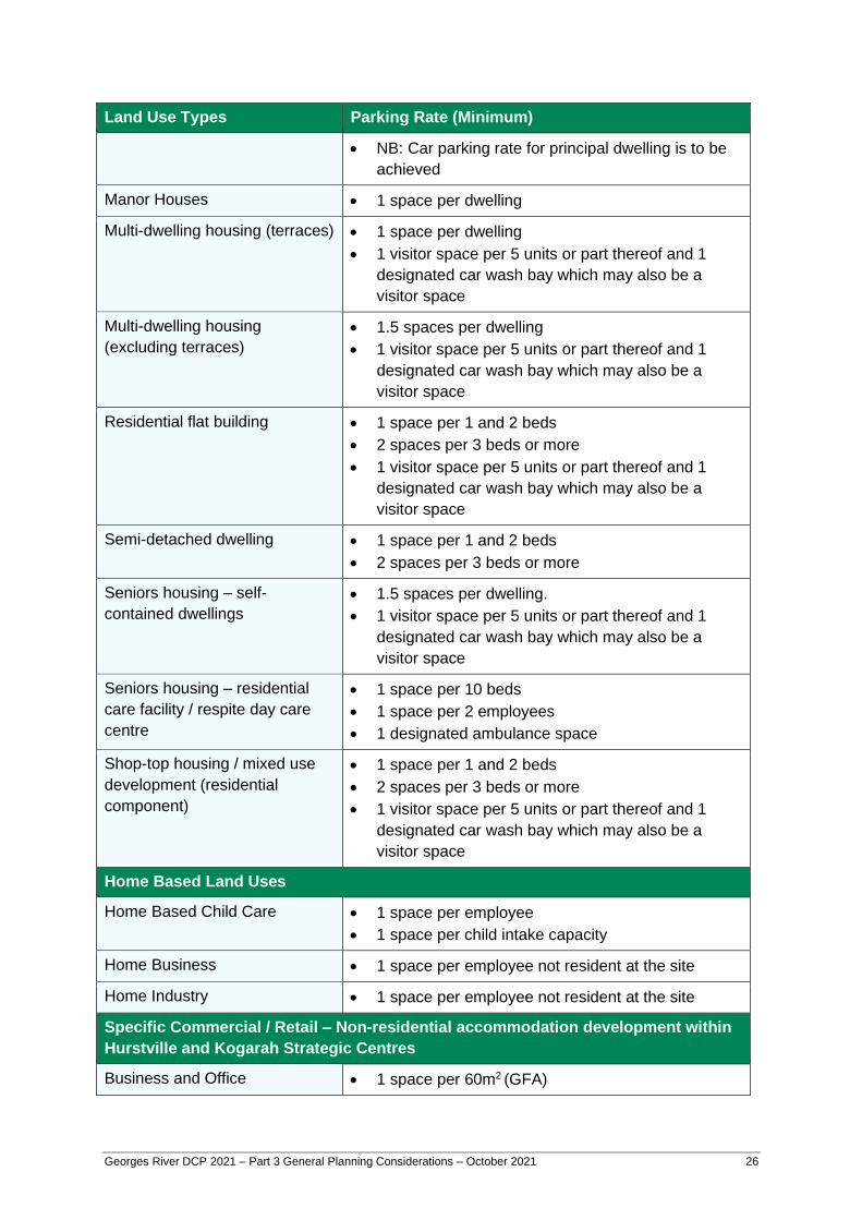
Georges River DCP 2021 – Part 3 General Planning Considerations – October 2021 26
Land Use Types Parking Rate (Minimum)
• NB: Car parking rate for principal dwelling is to be
achieved
Manor Houses • 1 space per dwelling
Multi-dwelling housing (terraces) • 1 space per dwelling
• 1 visitor space per 5 units or part thereof and 1
designated car wash bay which may also be a
visitor space
Multi-dwelling housing
(excluding terraces)
• 1.5 spaces per dwelling
• 1 visitor space per 5 units or part thereof and 1
designated car wash bay which may also be a
visitor space
Residential flat building • 1 space per 1 and 2 beds
• 2 spaces per 3 beds or more
• 1 visitor space per 5 units or part thereof and 1
designated car wash bay which may also be a
visitor space
Semi-detached dwelling • 1 space per 1 and 2 beds
• 2 spaces per 3 beds or more
Seniors housing – self-
contained dwellings
• 1.5 spaces per dwelling.
• 1 visitor space per 5 units or part thereof and 1
designated car wash bay which may also be a
visitor space
Seniors housing – residential
care facility / respite day care
centre
• 1 space per 10 beds
• 1 space per 2 employees
• 1 designated ambulance space
Shop-top housing / mixed use
development (residential
component)
• 1 space per 1 and 2 beds
• 2 spaces per 3 beds or more
• 1 visitor space per 5 units or part thereof and 1
designated car wash bay which may also be a
visitor space
Home Based Land Uses
Home Based Child Care • 1 space per employee
• 1 space per child intake capacity
Home Business • 1 space per employee not resident at the site
Home Industry • 1 space per employee not resident at the site
Specific Commercial / Retail – Non-residential accommodation development within
Hurstville and Kogarah Strategic Centres
Business and Office • 1 space per 60m2 (GFA)
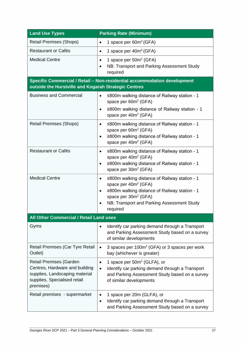
Georges River DCP 2021 – Part 3 General Planning Considerations – October 2021 27
Land Use Types Parking Rate (Minimum)
Retail Premises (Shops) • 1 space per 60m2 (GFA)
Restaurant or Cafés • 1 space per 40m2 (GFA)
Medical Centre • 1 space per 50m2 (GFA)
• NB: Transport and Parking Assessment Study
required
Specific Commercial / Retail – Non-residential accommodation development
outside the Hurstville and Kogarah Strategic Centres
Business and Commercial • ≤800m walking distance of Railway station - 1
space per 60m2 (GFA)
• ≥800m walking distance of Railway station - 1
space per 40m2 (GFA)
Retail Premises (Shops) • ≤800m walking distance of Railway station - 1
space per 60m2 (GFA)
• ≥800m walking distance of Railway station - 1
space per 40m2 (GFA)
Restaurant or Cafés • ≤800m walking distance of Railway station - 1
space per 40m2 (GFA)
• ≥800m walking distance of Railway station - 1
space per 30m2 (GFA)
Medical Centre • ≤800m walking distance of Railway station - 1
space per 40m2 (GFA)
• ≥800m walking distance of Railway station - 1
space per 30m2 (GFA)
• NB: Transport and Parking Assessment Study
required
All Other Commercial / Retail Land uses
Gyms • Identify car parking demand through a Transport
and Parking Assessment Study based on a survey
of similar developments
Retail Premises (Car Tyre Retail
Outlet)
• 3 spaces per 100m2 (GFA) or 3 spaces per work
bay (whichever is greater)
Retail Premises (Garden
Centres, Hardware and building
supplies, Landscaping material
supplies, Specialised retail
premises)
• 1 space per 50m2 (GLFA), or
• Identify car parking demand through a Transport
and Parking Assessment Study based on a survey
of similar developments
Retail premises - supermarket • 1 space per 20m (GLFA), or
• Identify car parking demand through a Transport
and Parking Assessment Study based on a survey

Georges River DCP 2021 – Part 3 General Planning Considerations – October 2021 28
Land Use Types Parking Rate (Minimum)
of similar developments
Retail Premises (Take away
food and drink premises)
Developments with no on-site seating or drive-through:
• 1 space per 100m2 (GFA)
Developments with no-site seating but no drive-
through:
• ≤800m walking distance of Railway station - 1
space per 40m2 (GFA)
• ≥800m walking distance of Railway station - 1
space per 30m2 (GFA)
Developments with on-site seating and drive-through:
• 1 space per 2 seats (internal), or
• 1 space per 3 seats (internal & external)
(whichever is the greater)
Service stations – convenience
store • 6 spaces per work bay (NB: stacked
parking acceptable)
• 1 space per 30m2 of convenience store (GFA)
Vehicle sales or hire premises • 1.5 spaces per 200m2 of site area,
• 6 spaces per work bay (NB: stacked
parking acceptable),
• 1 space per 25m2 of sales area (GFA)
• NB: Customer / visitor parking spaces must be
readily accessible from the principal road frontage
and appropriately signposted and marked. These
spaces must not be used for the display of vehicles
or other merchandise or for the loading/unloading
of vehicles onto or from car floats or trucks.
Tourist and Visitor Accommodation
Backpackers’ accommodation
• 1 space per manager
• 1 space per two employees
• 1 space for a mini-bus
Bed and Breakfast
accommodation • 1 space for resident owner or manager; plus
• 1 space per guest room
Hotel or motel accommodation
and serviced apartments • 1 space per 5 bedrooms / unit of accommodation
plus the requirements of any associated restaurant/
function room, etc.
• Provision to be made for off street accommodation
of buses and taxis.
Georges River DCP 2021 – Part 3 General Planning Considerations – October 2021 29
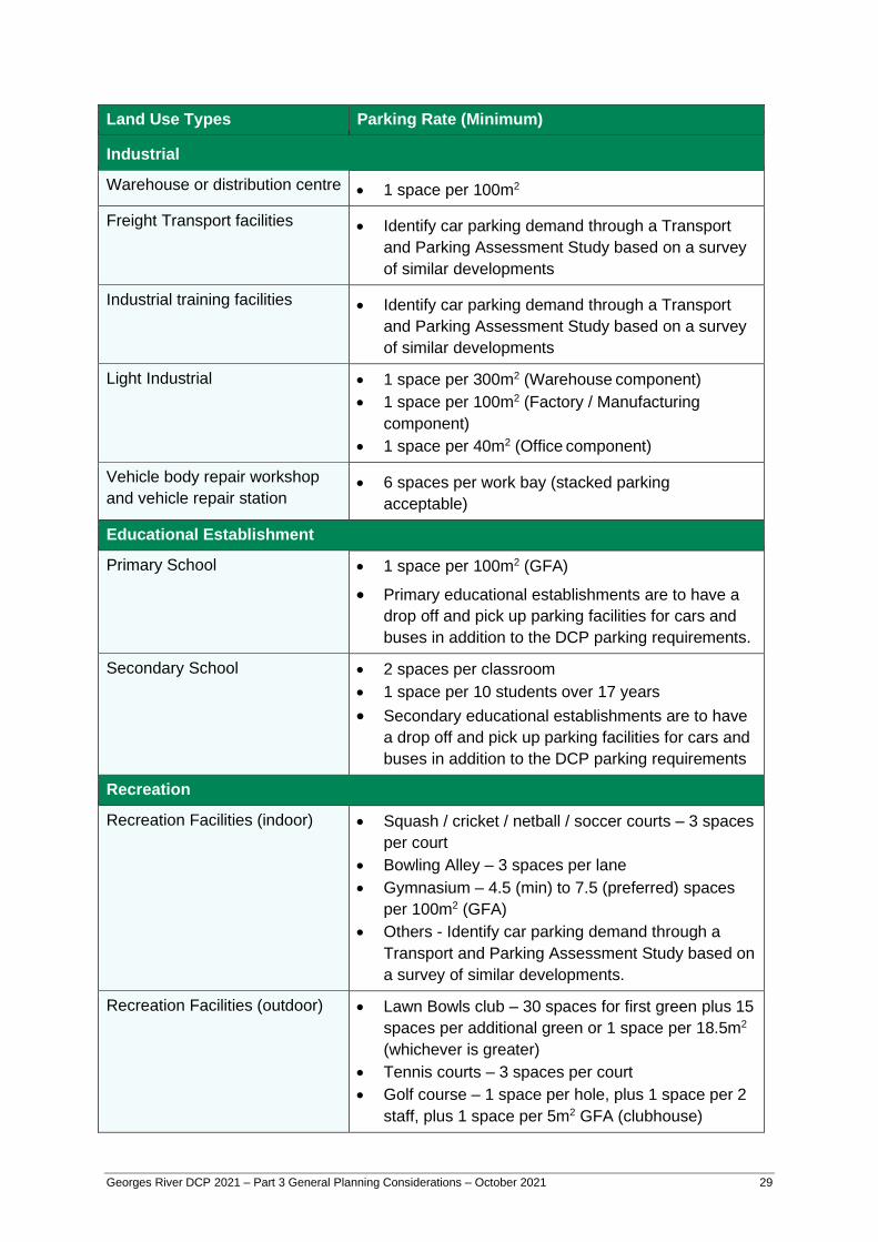
Land Use Types Parking Rate (Minimum)
Industrial
Warehouse or distribution centre • 1 space per 100m2
Freight Transport facilities • Identify car parking demand through a Transport
and Parking Assessment Study based on a survey
of similar developments
Industrial training facilities • Identify car parking demand through a Transport
and Parking Assessment Study based on a survey
of similar developments
Light Industrial • 1 space per 300m2 (Warehouse component)
• 1 space per 100m2 (Factory / Manufacturing
component)
• 1 space per 40m2 (Office component)
Vehicle body repair workshop
and vehicle repair station • 6 spaces per work bay (stacked parking
acceptable)
Educational Establishment
Primary School • 1 space per 100m2 (GFA)
• Primary educational establishments are to have a
drop off and pick up parking facilities for cars and
buses in addition to the DCP parking requirements.
Secondary School • 2 spaces per classroom
• 1 space per 10 students over 17 years
• Secondary educational establishments are to have
a drop off and pick up parking facilities for cars and
buses in addition to the DCP parking requirements
Recreation
Recreation Facilities (indoor) • Squash / cricket / netball / soccer courts – 3 spaces
per court
• Bowling Alley – 3 spaces per lane
• Gymnasium – 4.5 (min) to 7.5 (preferred) spaces
per 100m2 (GFA)
• Others - Identify car parking demand through a
Transport and Parking Assessment Study based on
a survey of similar developments.
Recreation Facilities (outdoor) • Lawn Bowls club – 30 spaces for first green plus 15
spaces per additional green or 1 space per 18.5m2
(whichever is greater)
• Tennis courts – 3 spaces per court
• Golf course – 1 space per hole, plus 1 space per 2
staff, plus 1 space per 5m2 GFA (clubhouse)
Georges River DCP 2021 – Part 3 General Planning Considerations – October 2021 30
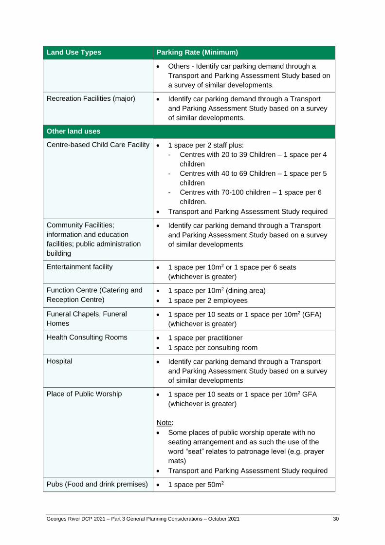
Land Use Types Parking Rate (Minimum)
• Others - Identify car parking demand through a
Transport and Parking Assessment Study based on
a survey of similar developments.
Recreation Facilities (major) • Identify car parking demand through a Transport
and Parking Assessment Study based on a survey
of similar developments.
Other land uses
Centre-based Child Care Facility • 1 space per 2 staff plus:
- Centres with 20 to 39 Children – 1 space per 4
children
- Centres with 40 to 69 Children – 1 space per 5
children
- Centres with 70-100 children – 1 space per 6
children.
• Transport and Parking Assessment Study required
Community Facilities;
information and education
facilities; public administration
building
• Identify car parking demand through a Transport
and Parking Assessment Study based on a survey
of similar developments
Entertainment facility • 1 space per 10m2 or 1 space per 6 seats
(whichever is greater)
Function Centre (Catering and
Reception Centre)
• 1 space per 10m2 (dining area)
• 1 space per 2 employees
Funeral Chapels, Funeral
Homes
• 1 space per 10 seats or 1 space per 10m2 (GFA)
(whichever is greater)
Health Consulting Rooms • 1 space per practitioner
• 1 space per consulting room
Hospital • Identify car parking demand through a Transport
and Parking Assessment Study based on a survey
of similar developments
Place of Public Worship • 1 space per 10 seats or 1 space per 10m2 GFA
(whichever is greater)
Note:
• Some places of public worship operate with no
seating arrangement and as such the use of the
word “seat” relates to patronage level (e.g. prayer
mats)
• Transport and Parking Assessment Study required
Pubs (Food and drink premises) • 1 space per 50m2

Georges River DCP 2021 – Part 3 General Planning Considerations – October 2021 31
Land Use Types Parking Rate (Minimum)
Restricted Premises • 1 space per 50m2 (excluding drive-in liquor stores)
• 1 space per 50m2 and queuing space for 3 vehicles
for drive-in liquor stores
Registered clubs (excluding
residential) and nightclubs
• Identify car parking demand through a Transport
and Parking Assessment Study based on a survey
of similar developments
Sex Services Premises • 1 space per 25m² (GFA)
Small Bar • Identify car parking demand through a Transport
and Parking Assessment Study based on a survey
of similar developments
Veterinary Hospitals • 1 space per practitioner
• 1 space per consulting room
Table 1: Off-street Car Parking requirements
Parking Credits
6. A parking credit is available when developing a site already occupied by a building.
Provided the development retains the structure of the existing building, the proposed
development will be exempted from the parking requirements for the existing floor
space.
7. Where the development is for the change of use of an existing building and the new
use requires more parking than the old use, the credit is for the original use, even
though the floor space may not be increasing. For example, converting a warehouse
with no parking into a shop, with no increase in floor space would still be required to
provide extra parking but this will be for the shop requirement minus the warehouse
requirement.
Bicycle Parking
8. All Commercial, Place of Public Worship, Residential flat building and Shop-top
housing development is to provide on-site bicycle parking as outlined in Table 2 –
Bicycle Parking Requirements.
Land use Bicycle Parking rate (minimum)
Commercial development including
commercial component of a mixed
use development
• 1 space per 5 car parking spaces
Places of Public Worship • 1 space per 5 car parking spaces

Georges River DCP 2021 – Part 3 General Planning Considerations – October 2021 32
Residential flat building • 1 space per 3 dwellings plus 1 space per 10
dwellings (visitors)
Shop-top housing / mixed use
development (residential
component)
• 1 space per 3 dwellings plus 1 space per 10
dwellings (visitors)
Table 2: Bicycle Parking requirements
9. In calculating the total number of bicycle spaces required for a development type, the
total should be rounded up to the nearest whole number (i.e. 0.5 or greater).
10. Bicycle parking facilities are to be designed in accordance with Australian Standard
AS2890.3 (Parking Facilities – Part 3 Bicycle Parking Facilities).
End of Trip Facilities
11. For non-residential uses, the following facilities for bike parking are to be provided at
the following rates:
i. 1 personal locker for each bike parking space;
ii. 1 shower and change cubicle for up to 10 bike parking spaces;
iii. 2 shower and change cubicles for 11 to 20 or more bike parking spaces are
provided;
iv. 2 additional showers and cubicles for each additional 20 bike parking spaces or
part thereof;
v. Showers and change facilities may be provided in the form of shower and
change cubicles in a unisex area in both female and male change rooms; and
vi. Locker, change room and shower facilities are to be located close to the bike
parking area, entry and exit points and within an area of security camera
surveillance where there are such building security systems.
Design and Layout of Car Parking Areas
12. Internal car park layouts, space dimensions, ramp grades, access driveways, internal
circulation aisles and service vehicle areas shall be designed in accordance with the
requirements set out in AS 2890.1 (2004) and AS 2890.2 (2002) for off street parking
and commercial vehicles.
13. Design vehicular access in accordance with the current Australian Standard for ‘off-
street parking (Part 1) ‘and ‘off-street carparking for commercial vehicles (Part 2)’.
14. For mixed use development, residential off-street parking facilities shall be separated
from the other uses and security roller doors shall be installed to provide security to
residents.

Georges River DCP 2021 – Part 3 General Planning Considerations – October 2021 33
Basement Parking
15. Basement car parking is preferable in commercial and residential flat buildings.
16. Basement car parking is to be located within the building footprint.
17. All basement parking areas are to have security doors.
18. Include natural ventilation to basement and semi basement car parking.
19. Integrate ventilation design into the façade of the building, or parking structure, treating
it with appropriate features such as louvres, well designed grilles, planting or other
landscaping elements.
At Grade Parking
20. Car parking areas may be designed as ground level parking provided that the design
results in building frontages level with the street.
21. Parking areas are to include:
i. Planting beds fronting a street or public place are to have a minimum width of 1
metre, unless otherwise specified elsewhere in this DCP.
ii. Shade trees are to be provided in open parking areas at the ratio of 1 shade tree
for every 6 spaces.
iii. Plants to avoid are those which have a short life, drop branches, gum or fruit or
those which interfere with underground pipes.
22. Parking areas are to incorporate a 150mm concrete kerb or edge treatment to reduce
the likelihood of vehicles damaging adjoining landscaped areas. The use of bollards
should also be considered.
Parking for People with a Disability
23. Parking complies with AS 1428 Design for access and mobility and AS/NZS 2890.6.
24. All off-street parking facilities shall allocate accessible parking spaces for people with
disabilities at the rate in accordance with Section 3.17 – Universal/ Accessible Design
of this DCP.
25. Accessible parking spaces shall be located close to an accessible lift, ramp or building
entrance and be provided with an accessible path of travel.
26. Accessible parking spaces shall be indicated by a permanent sign as specified in AS
1428.1.
27. For residential development, accessible car parking spaces are to be allocated to
adaptable unit, or as visitor parking.

Georges River DCP 2021 – Part 3 General Planning Considerations – October 2021 34
Car Washing Area
28. A designated car washing area (which may also be a designated visitor car space) is
required residential developments of four or more dwellings.
29. Car wash bays which collect waste water must be covered and discharge the water to
the sewer in accordance with the requirements of Sydney Water.
Pedestrian
30. Design parking to ensure pedestrian safety.
31. Pedestrian entrances and exits shall be separated from vehicular access paths.
Access
32. Design driveways to minimise visual impact on the street and maximise pedestrian
safety.
33. Ensure that all vehicles, including vehicles using loading bays, can enter and leave the
site in a forward direction.
34. Avoid locating accessways to driveways adjacent to the doors or windows of habitable
rooms.
Materials
35. All driveways are to be finished in plain concrete
36. In streets which have brick paved surfaces, driveways are constructed to Council’s
Engineering Specification including a concrete base with matching brick paving
surface.
37. Large areas of at grade carparking are to be constructed of concrete or a light
coloured material to minimise heat load. Tree planting within the carparking will be
required to provide shade.
Tandem, stacked and mechanical parking areas
Mechanical parking installations means mechanical car stackers, car lifts and turntables.
Stacked parking means sharing a parking space vertically through use of a mechanical car
stacker.
Tandem parking means two or more vehicles sharing a parking space at the same level
configured nose to tail.

Georges River DCP 2021 – Part 3 General Planning Considerations – October 2021 35
38. Where development includes a mechanical parking installation, such as car stackers,
turntables, car lifts or another automated parking system, the development application
is to include a Parking and Access Report including queuing analysis.
39. Access to mechanical parking installations is to be in accordance with the relevant
Australian Standards.
40. Tandem or stacked parking will only be permitted where:
i. Each tandem or stacked parking arrangement is limited to a maximum of two
spaces;
ii. The maximum parking limit for spaces is not exceeded;
iii. They are not used for service vehicle parking;
iv. The spaces are attached to the same strata title in residential buildings and small
commercial or retail developments;
v. In residential buildings and serviced apartments, they are used for tenant parking
only;
vi. In commercial or retail development, they are used for staff parking only; and
vii. The manoeuvring of and queuing for stacked vehicles are able to occur wholly
within the premises, without obstructing the entry or egress of other vehicles.
41. Mechanical parking installations will be considered for developments involving the
adaptive re-use of existing buildings where site or building constraints prevent
standard parking arrangements and no inconvenience arises from their use.
42. Mechanical parking installations, tandem or stacked parking are not to be used for
visitor parking or parking for car share schemes.
43. The minimum length of a tandem space is to be 10.8m.
44. Car lifts will only be considered where it can be demonstrated that a basement ramp is
not feasible/achievable.
45. Where a car lift is required, car lifts are to be provided at a minimum rate of 1 lift per 25
spaces or part thereof.
Note: Queuing analysis must be completed in accordance with Australian Standard
AS2890.1 and Ausroads “Guide to Traffic Management”. The assessment is to establish
whether the mechanical lift requires queuing to be accommodated on the property noting
that queuing of vehicles on public roads will not be supported.
Car share
46. Parking car share spaces are encouraged for:
i. Any residential development containing more than 25 residential units, or
ii. Any employment generating development with a floor space of 5,000m2, and

Georges River DCP 2021 – Part 3 General Planning Considerations – October 2021 36
iii. Is located within 800 metre radial catchment of a railway station, or within a
transit node entre that is serviced by a strategic bus corridor.
47. A car share parking proposal is to be supported by a parking study.
48. Council may consider car share spaces in lieu of some resident parking, subject to
evidence of an appropriate arrangement with a car share scheme provider.
49. Clearly marked plans identifying the location of all car share parking spaces must be
submitted with the development application.
50. All car share parking spaces are to be:
i. Publicly accessible 24 hours a day seven days a week;
ii. Located together;
iii. Located near and with access from a public road and integrated with the
streetscape through appropriate landscaping where the space is external; and
iv. Clearly designated by signs as being for car share scheme use.
51. Car share parking spaces located on private land are to be retained as common
property by the Owners Corporation of the site and not to be sold or leased to an
individual owner or occupier at any time.
Loading Requirements
52. Planning and design layout of loading and manoeuvring areas should be provided in
accordance with AS2890.2 and:
i. Preferably be located to the side or rear of buildings;
ii. Screened from view from local and main roads; and
iii. Located so that vehicles stand wholly within the dedicated loading/unloading
area and do not obstruct the car parking on the subject property or public road,
footway, laneway or service road.
53. Loading bay facilities are to be provided at the following rates:
Retail Floor area >100m2 to 500m2 – 1 bay required
Floor area > 500m2 to 1500m2 – 2 bays required
Commercial Floor area 1000m2 to 5000m2 – 1 bay required
Floor area > 5000m2 to 10000m2 – 2 bays required
Table 3: Loading bay parking requirements
54. The design of loading bay facilities are to be in accordance with Australian Standard
AS2890.2 and Table 4 below.

Georges River DCP 2021 – Part 3 General Planning Considerations – October 2021 37
Vehicle Class Bay length m
Min.
Platform height m Vertical Clearance m
Min.
SRV 7.4 0.75 to 0.90 3.5
MRV 9.8 0.95 to 1.10 4.5a
HRV 13.5 1.10 to 1.40 4.5a
AV 21.0 1.10 to 1.40 4.5a
a 4.8m for animal transport vehicles, vehicle carriers and 4.6m high vehicles or where access to the top
of a tall vehicle, e.g. pantechnicon or load is required.
Table 4: Service bay dimensions
3.14 Utilities Objectives
(a) Ensure that the necessary services are provided to cater for future occupants.
(b) Ensure that development that integrates required services in building and site design
to minimise impacts on the streetscape.
Controls
1. Applicants should consult service providers for energy, electricity, gas, water,
telephone, national broadband network (NBN) fibre cables and fire requirements.
2. Any services and structures required by the providers should be located within the
basement, or concealed within the facade, with appropriate access. Where this is not
possible, an alternative method of minimising street impact should be demonstrated,
such as screening with landscape or built elements.
3. With the exception of dwelling houses, all buildings should accommodate proposed or
future air conditioning units within the basement or on rooftops, with provision of
associated vertical/ horizontal stacks to all sections of the building.
4. Air conditioning units and mechanical plant located on the roof should be well
screened and integrated into the building form.
5. Air conditioning units and mechanical plant should be sited away from adjacent
sensitive land uses and/or screened by walls or other acoustic treatments.
6. Car parking areas are to be designed and constructed so that electric vehicle and
bicycle charging points can be installed now or at a later date. This will include the
provision of 3 phase power to car parking areas for residential flat buildings, shop top
housing and non-residential buildings.
7. For all future roaded subdivisions, electricity supply is to be installed underground.
8. The existing above ground electricity and telecommunication cables within the road
reserve and within the site will be replaced, at the applicant’s expense, by
Georges River DCP 2021 – Part 3 General Planning Considerations – October 2021 38
underground cable and appropriate street light standards, in accordance with the
Energy and Communication Provider’s guidelines.
3.15 Public Domain
3.15.1 Infrastructure
Objectives
(a) Create an integrated space that is attractive, legible, comfortable, safe and engaging.
(b) Encourage pedestrian and cyclist use.
(c) Increase the amount and quality of public leisure spaces.
(d) Ensure increased urban greening.
Controls
1. All proposed public domain works are to be undertaken in accordance with the
relevant Council Public Domain Plan.
2. Where there is no public domain plan for the precinct, a public domain plan for the site
and associated public domain is to be prepared and submitted with the development
application in consultation with Council.
3. Embellishment of the public domain should include new street furniture, new street
plantings and footpath improvements.
4. New street furniture should comply with the relevant Council Public Domain Plan in
respect of its material, colour, size, shape and location. This is subject to aspects of
safety and compatibility with the development and adjacent development being
considered.
5. Where there is no Public Domain plan, Council’s use of a particular style of street
furniture as a signature of the Council area or suburb must be respected.
6. The installation of hostile architectural features in areas accessible to the public is not
permitted. Hostile architecture includes a restriction on the design and installation of
items such as: slanted or curved benches, rocky pavements, spiked windowsills,
segmented benches, street spikes, awning gaps, barred corners, street dividers,
raised grate covers, tiered seating, fence grates, retractable spikes and the like.
7. The cost of all public domain works will be borne by the applicant.
3.15.2 Public Art Objectives
(a) Enhance the sense of place through the provision of public art.
Georges River DCP 2021 – Part 3 General Planning Considerations – October 2021 39
(b) Promote sustainability through public art in new development.
(c) Ensure that public art is an integrated and cohesive part of new development.
(d) Recognise and build on the cultural identity and diversity through interpretive public
art.
Controls
1. Major developments (commercial, public administration, and retail development) and
mixed-use developments with a capital investment value of $5 million or more are to
include an element of public art.
2. A minimum of 1% of the total cost of the development is to be allocated to the public
art budget.
3. Details of the nature of the work, its approximate location and size are to accompany
the development application.
4. Developers should consult the Georges River Council Public Art Guidelines, to
determine any requirements for including public art in new developments, and to
review what constitutes public art.
5. The application must include a Public Art Plan which addresses how the proposed
public art meets the following Design Selection Criteria:
i. Standards of excellence and innovation.
ii. Relevance and appropriateness of the work in relation to its site.
iii. Its contribution to creating sense of place, and integration into the built form.
iv. Where possible, participation of local artists, local groups, youth or indigenous
groups.
v. Consideration for public safety and the public’s use of and access to the public
space.
vi. Consideration of maintenance and durability requirements of materials, including
potential for vandalism and graffiti.
vii. Where applicable, consistency with current planning, heritage and environmental
policies and plans of management.
viii. Evidence of appropriate Public Liability Insurance to cover construction and
installation of work.

Georges River DCP 2021 – Part 3 General Planning Considerations – October 2021 40
3.16 Subdivision
3.16.1 Lot Size and Shape
Objectives
(a) Ensure that lot sizes and street frontages can support the desired building type and
use and achieve internal spaces appropriate to their function.
Controls
1. Development is to comply with the minimum Lot Standard as prescribed in Clauses 4.1
through to 4.1B of the Georges River LEP 2021 and associated maps where
applicable.
2. New allotments for dwelling houses are to have a minimum width of 15m for the entire
allotment.
3. Battle-axe allotments are to comply with the access requirements outlined below in
Table 5.
Zone Number of lots per
access corridor
(Maximum)
Width of access handle
(Minimum)
R2 Low Density Residential
R3 Medium Density Residential
6
≤ Two (2) lots – 3m
> Two (2) lots – 6m
IN2 Light Industrial 2 6m
Table 5: Battle-axe lots – access requirements
4. Easement widths are to comply with Council’s Stormwater Management Policy,
specifically 3.5.2 Required Easement Widths.
5. Where the topography of a site requires separate pedestrian access or is only
accessible by the use of an inclinator, an accessway with a minimum width of 2 metres
is to be provided.
6. Corner allotments may be required to provide a 3m x 3m splay corner (road to road),
or 1.5m x 1.5m (lane to road).
Note: Applicants are advised to consult with Council staff prior to lodgement of any
development application to determine specific requirements.
7. Newly created allotments must include an indicative building envelope to demonstrate
how solar access, vehicular access, setbacks, landscaped areas and tree preservation
can be achieved.
Georges River DCP 2021 – Part 3 General Planning Considerations – October 2021 41
3.16.2 Roads, Vehicular Access and Car Parking
Objectives
(a) Ensure road design takes into account connectivity, legibility and permeability whilst
catering for the safety of all road users (i.e. motor vehicles, pedestrians and cyclists).
(b) Ensure road construction meets minimum standards.
(c) Ensure adequate vehicular access and car parking is provided to allotments, relative to
subdivision type and site constraints without adversely impacting the natural
environment.
Controls
1. Public roads are to be constructed in accordance with the relevant Australian
Standards and relevant road authority’s policy and specifications on road design and
safety guidelines.
2. Pedestrian footpaths or shared pathways / cycle ways are to be designs in accordance
with AS 1428 Design for access and mobility.
3. Consent should be obtained from the relevant road authority under the Roads Act
1993 for each opening of a public road associated with development.
4. Driveways and car parking are to be constructed in accordance with AS 2890.1-
(2004), Parking facilities – Off-street car parking and with the relevant road authority’s
policy and specifications on vehicle and driveway crossings.
5. Driveways and car parking must satisfy the requirements in Section 3.13 – Parking
and Access of this DCP and comply with the relevant DCP controls according to the
development type.
3.16.3 Utilities and Services Objectives
(a) Ensure that allotments are adequately serviced by appropriate utility services.
Controls
1. Development is to comply with requirements outlined in Clause 6.9 Essential services
of the Georges River LEP 2021.
2. Service supply to multiple battle-axe subdivisions is to be provided by underground
cable. Confirmation that this has been arranged is required in writing from the relevant
authority before approval and release of plans.
3. Adequate space for the storage of waste and recycling bins is to be provided on the
site in an accessible location as outlined in Council’s Waste Management

Georges River DCP 2021 – Part 3 General Planning Considerations – October 2021 42
Requirements Policy (Appendix 4) and Section 3.12 – Waste Management of this
DCP.
3.16.4 Drainage Objectives
(a) Ensure subdivisions are fully drained to Council standards according to subdivision
type.
Controls
1. Comply with the requirements outlined in Council’s Stormwater Management Policy.

Georges River DCP 2021 – Part 3 General Planning Considerations – October 2021 43
3.17 Universal / Accessible Design Objectives
(a) Ensure all publicly accessible buildings provide a safe and continuous path of travel for
people with impaired mobility.
(b) Provide residential development that includes adaptable units and accessible
residential accommodation to address potential demand.
Controls
General
1. All new building work should comply with the accessibility provisions of the Building
Code of Australia (BCA) and the Disability (Access to Premises - Buildings) Standards
2010 where required.
2. Continuous unobstructed paths of travel should be provided from public footpaths,
accessible car parking, and set down areas to public building entrances. Paths of
travel should be designed in accordance with the Disability (Access to Premises -
Buildings) Standards 2010.
3. Accessways for pedestrians and for vehicles are to be separated.
Seniors Housing
4. Access is to be provided in accordance with the requirements of SEPP (Housing for
Seniors or People with a Disability) 2004.
Heritage Buildings
5. Access to heritage buildings should be provided that is sympathetic to the heritage
significance of the building and its curtilage.
Medium and High Density Residential Developments
6. Refer to detailed requirements outlined in Part 6.2 – Multi dwelling housing, Multi-
dwelling housing (terraces) and Manor Houses and 6.3 – Residential Flat Buildings of
this DCP and below in Table 6.
Accessible Parking
7. All off-street parking facilities shall allocate accessible parking spaces for people with
disabilities outlined below in Table 6.

Georges River DCP 2021 – Part 3 General Planning Considerations – October 2021 44
Land Uses Accessible Parking rate (minimum)
Commercial premises 1-2% of total car parking spaces
Passenger Transport Facility
e.g. railway stations, bus/ rail
interchanges
1-3% of total car parking spaces
Community and Recreation
Facilities e.g. civic centres and
gyms
2-3% of total car parking spaces
Educational Establishments 2-3% of total car parking spaces
Entertainment Facilities e.g.
theatres, libraries, sport centres
3-4% of total car parking spaces
Health Service Facilities e.g.
medical centres, clinics,
community health centres
3-4% of total car parking spaces
Places of Public Worship To be provided as needed in consultation with
management of the premises.
Medium and High Density
Residential Development
1 space per Adaptable unit as per AS2890.6
Table 6: Accessible parking requirements
Notes: For further information, refer to the Disability (Access to Premises - Buildings)
Standards 2010 available at www.ag.gov.au.
An access report, prepared by a relevantly qualified access consultant may be required for
development that involves the following:
i. Medium to high density residential developments with 10 or more dwellings, or
ii. Housing for Aged or People with Disabilities, or
iii. Other developments that are required to comply with the Disability (Access to
Premises - Buildings) Standards 2010.
Adaptable Housing is defined by Australian Standard AS 4299, which is specifically
designed to allow for the future adaptation of a dwelling to accommodate the occupant’s
needs.
Accessible Car Parking Provision Universal Design is an international design philosophy that
enables people to continue living in the same home by ensuring that apartments are able to
change with the needs of future occupants.
Universally designed apartments provide design features such as wider circulation spaces,
larger car parking spaces, reinforced bathroom walls and easy to reach and operate fixtures

Georges River DCP 2021 – Part 3 General Planning Considerations – October 2021 45
in accordance with the Liveable Housing Guidelines (2017) available online at
livablehousingaustralia.org.au.
3.18 Advertising and Signage Objectives
(a) Ensure signage is compatible with the character of the locality and protects the
amenity of the area.
(b) Promote signage that complements the scale, size and architecture of the building or
structure on which it is displayed.
(c) Ensure signage does not compromise pedestrian, cyclist or motorist safety.
Controls
1. Signs should be designed and located to:
i. Relate to the use of the premises.
ii. Be consistent with best practice guidelines.
iii. Be integrated with the architecture of the supporting building, not obscure
significant architectural features and maintain the dominance of the architecture.
iv. Be limited in number to avoid cluttering, distraction and unnecessary repetition.
v. Not cover mechanical ventilation inlets or outlets.
vi. Not comprise a roof sign.
vii. Not comprise an above awning sign.
viii. Not comprise a flag pole sign.
ix. Not compromise road or pedestrian safety including cyclists.
x. Be a minimum of 2.6 metres above any footpath where the sign is not flush with
the wall.
xi. Be at least 600mm from a kerb or roadway edge where the sign is over a public
road.
2. Signs must be securely fastened to the structure or building to which they are attached
and must comply with the applicable requirements of the BCA and relevant Australian
Standards.
3. In addition to the above, illumination of signage should:
i. Be integrated with the design of the sign.
ii. Not cause light spillage into nearby residential properties.
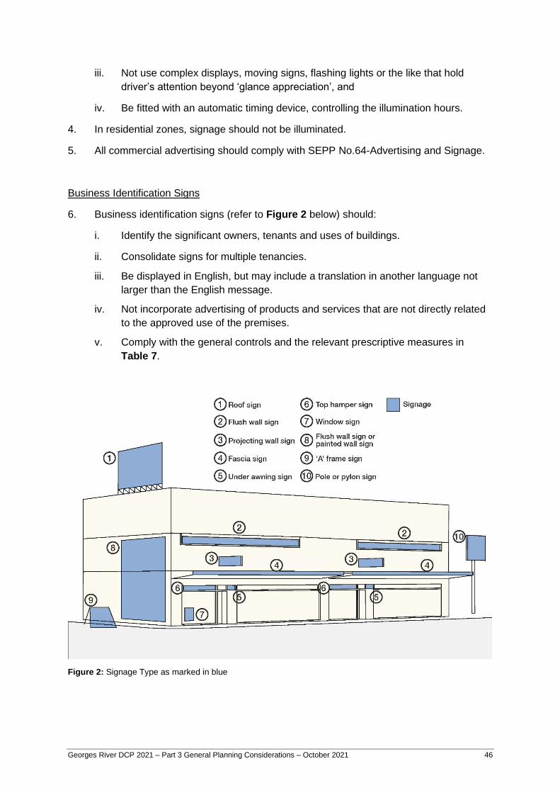
Georges River DCP 2021 – Part 3 General Planning Considerations – October 2021 46
iii. Not use complex displays, moving signs, flashing lights or the like that hold
driver’s attention beyond ‘glance appreciation’, and
iv. Be fitted with an automatic timing device, controlling the illumination hours.
4. In residential zones, signage should not be illuminated.
5. All commercial advertising should comply with SEPP No.64-Advertising and Signage.
Business Identification Signs
6. Business identification signs (refer to Figure 2 below) should:
i. Identify the significant owners, tenants and uses of buildings.
ii. Consolidate signs for multiple tenancies.
iii. Be displayed in English, but may include a translation in another language not
larger than the English message.
iv. Not incorporate advertising of products and services that are not directly related
to the approved use of the premises.
v. Comply with the general controls and the relevant prescriptive measures in
Table 7.
Figure 2: Signage Type as marked in blue
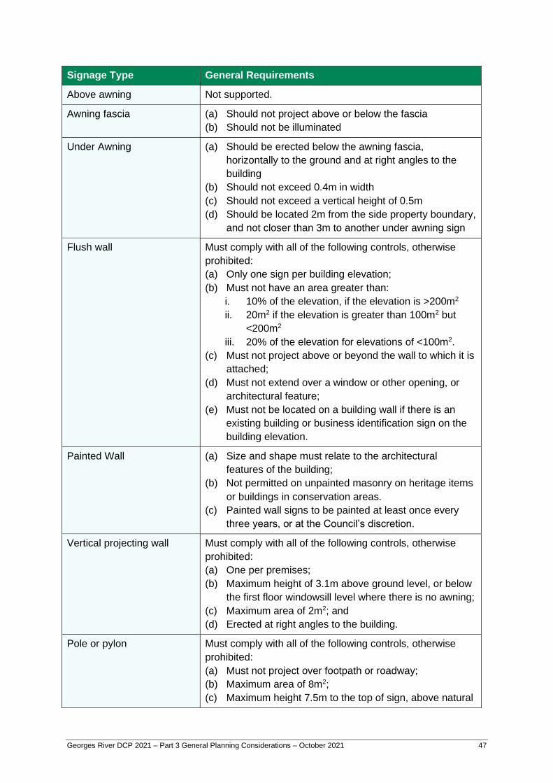
Georges River DCP 2021 – Part 3 General Planning Considerations – October 2021 47
Signage Type General Requirements
Above awning Not supported.
Awning fascia (a) Should not project above or below the fascia
(b) Should not be illuminated
Under Awning (a) Should be erected below the awning fascia,
horizontally to the ground and at right angles to the
building
(b) Should not exceed 0.4m in width
(c) Should not exceed a vertical height of 0.5m
(d) Should be located 2m from the side property boundary,
and not closer than 3m to another under awning sign
Flush wall Must comply with all of the following controls, otherwise
prohibited:
(a) Only one sign per building elevation;
(b) Must not have an area greater than:
i. 10% of the elevation, if the elevation is >200m2
ii. 20m2 if the elevation is greater than 100m2 but
<200m2
iii. 20% of the elevation for elevations of <100m2.
(c) Must not project above or beyond the wall to which it is
attached;
(d) Must not extend over a window or other opening, or
architectural feature;
(e) Must not be located on a building wall if there is an
existing building or business identification sign on the
building elevation.
Painted Wall (a) Size and shape must relate to the architectural
features of the building;
(b) Not permitted on unpainted masonry on heritage items
or buildings in conservation areas.
(c) Painted wall signs to be painted at least once every
three years, or at the Council’s discretion.
Vertical projecting wall Must comply with all of the following controls, otherwise
prohibited:
(a) One per premises;
(b) Maximum height of 3.1m above ground level, or below
the first floor windowsill level where there is no awning;
(c) Maximum area of 2m2; and
(d) Erected at right angles to the building.
Pole or pylon Must comply with all of the following controls, otherwise
prohibited:
(a) Must not project over footpath or roadway;
(b) Maximum area of 8m2;
(c) Maximum height 7.5m to the top of sign, above natural

Georges River DCP 2021 – Part 3 General Planning Considerations – October 2021 48
Signage Type General Requirements
ground level;
(d) Where more than one pole or pylon sign is provided,
they must have the same setback and be of uniform
design and spacing;
(e) Message must relate to use of the premises; and
(f) The requirements of SEPP 64 should also be
consulted.
Roof or Sky Sign Refer to SEPP 64, otherwise not supported.
A-frame, sandwich and
board signs
(a) Where site constraints make it difficult to provide a
fixed sign, a moveable sign may be supported.
(b) Sign must be portable, free standing, stable, windproof
and of high quality.
(c) Signs must be between 0.75m -1.1.m in height and a
maximum width of 0.65m.
(d) Should be located to maintain an unencumbered
pedestrian thoroughfare of 2 metres where located on
a public footpath.
(e) Maximum of one sign per street fronted premises
unless combined frontage exceeds 11m.
(f) Signs must only be displayed during approved trading
hours and are to be removed at the close of business.
(g) All signs must display a current Approved Sign/Stand
sticker (under development).
(h) Signs are not to be placed within 3 metres of a street
corner or an arcade.
(i) Signs must not be fixed to the footway, poles or
infrastructure
Moving sign/video
sign/electronic message
board
Well-designed “moving image” signs may be acceptable in
special circumstances where there is no nuisance to traffic
or pedestrians and where it can be considered as a
“landmark” sign.
Temporary Community
Banner
Refer to SEPP (Exempt and Complying Development
Codes) 2008.
Billboard (free standing) Refer to SEPP 64.
Business Directory Board Only one per premise.
Table 7: Signage Requirements
Signs on Parked Vehicles
7. Advertising signs on parked vehicles (cars, trucks, motorcycles, trailers etc.) are
prohibited where the vehicle is unregistered or the principal purpose of the vehicle is
for advertising purposes.
Georges River DCP 2021 – Part 3 General Planning Considerations – October 2021 49
Large Developments
8. Advertising signs for large commercial type developments and those that contain
multiple tenancies should be the subject of a co-ordinated approach to the design and
siting of signs.
New Developments
9. For new buildings, the location, type and total number of advertising signs should be
considered at the development application stage so that they can be integrated into
the design of buildings. This information is to be included as part of any development
application for a new building.
Specific Criteria for the Light Industrial Zone
10. The total advertising area on each site is not to exceed 0.5m2 per linear metre of road
frontage for premises with a single road frontage and 0.25m2 per linear metre for
premises with two street frontages.
11. Multiple occupancy buildings or sites may be identified at the entrance by freestanding
directory boards within the front setback, identifying the names and activities of
occupants.
12. Signs displayed on units in multiple occupancies should be of a uniform shape, size
and general presentation. No more than one identification sign and number is
permitted for each approved unit or occupancy.
13. No sign is permitted to stand higher than the roof line of the building to which it is
affixed.
14. The content of any advertising sign must relate to the premises on which the sign is
erected or the activities carried out within the premises, except in the case of a
Billboard Sign where it can be demonstrated that general advertising will have no
detrimental impact on nearby residential areas or pedestrians, or cause a distraction to
motorists.
3.19 Crime Prevention / Safety and Security Objectives
(a) Provide a safe environment and minimise opportunities for criminal and anti-social
behaviour.
Controls
Surveillance

Georges River DCP 2021 – Part 3 General Planning Considerations – October 2021 50
1. Active spaces and windows of habitable rooms within buildings are to be located to
maximise casual surveillance of streets, laneways, parking areas, public spaces and
communal courtyard space.
2. In commercial, retail or public buildings, facilities such as toilets and parents rooms are
to be conveniently located and designed to maximise casual surveillance to facility
entries.
3. Minimise blind-corners, recesses and other external areas that have the potential for
concealment or entrapment.
4. Building entries are to be clearly visible, unobstructed and easily identifiable from the
street, other public areas and other development. Where practicable lift lobbies,
stairwells, hallways and corridors should be visible from the public domain.
5. Ground floors of non-residential buildings, the non-residential component of mixed use
developments, and the foyers of residential buildings, are to be designed to enable
surveillance from the public domain to the inside of the building at night.
6. Pedestrian routes from car parking spaces to lift lobbies are to be as direct as possible
with clear lines of sight along the route.
Access Control
7. Where dwelling units have individual main entries directly from a public space, the
entry is to include a clearly defined transitional space between public and private
areas.
8. Development should comprise elements that contribute to effective access control by
creating:
i Landscapes and physical locations that channel and group people into public
areas;
ii Public spaces that attract, rather than discourage people from gathering; and
iii Restricted access to high crime risk areas such as car parks and other rarely
visited areas.
9. Building details such as fencing, drainpipes and landscaping are to be designed so
that illegitimate access is not facilitated by the opportunity for foot or hand-holds,
concealment and the like.
Territorial Reinforcement
10. Development should incorporate design elements that contribute to the creation of a
sense of community ownership of public spaces by:
i Encouraging people to gather in public spaces and feel some responsibility for its
use and condition;
Georges River DCP 2021 – Part 3 General Planning Considerations – October 2021 51
ii Clearly defining transitions and boundaries between public and private spaces;
and
iii Clearly defining the use of public spaces.
3.20 Noise and Vibration
3.20.1 Aircraft Noise and OLS
Objectives
(a) Minimise adverse impacts from noise from Sydney Airport and Bankstown Airport.
(b) Ensure that developments do not adversely impact on the Procedures for Air
Navigation Systems Operations (PANS-OPS) and Obstacle Limitation Surfaces (OLS)
for Sydney (Kingsford Smith) Airport and Bankstown Airport.
Controls
1. Buildings exposed to aircraft noise are to be designed and constructed in accordance
with the relevant Australian Standard (i.e. AS 2021-2000 – Acoustics- Aircraft noise
intrusion – Building siting and construction).
2. If the building is located within a specific area identified on the OLS map or seeks to
exceed the height limit specified in the map the application must be referred to Civil
Aviation Safety Authority and Airservices Australia for assessment.
3. Developments must consider the operating heights of all construction cranes or
machinery (short term controlled activities) that may exceed the OLS height limits
thereby penetrating the prescribed airspace. Consideration should be given to the
timing and location for the proposed controlled activity on site for referral to Civil
Aviation Safety Authority and Airservices Australia.
4. Approval to operate construction equipment (i.e. cranes) shall be obtained prior to any
commencement of construction, where the prescribed airspace is affected.
Note: Please contact Council for advice to whether or not your Development Application is
required to be referred to SACL. Proposals with a height of RL15.24 or greater will be
referred to SACL for approval.
3.20.2 Development near Road and Rail Corridors
Objectives
(a) Ensure an appropriate acoustic amenity can be achieved for development near
transport corridors, particularly residential development and other noise sensitive land
uses.
(b) Provide additional acoustic design or mitigation measures that may be necessary.

Georges River DCP 2021 – Part 3 General Planning Considerations – October 2021 52
(c) Development fronting a busy road or a rail corridor should be designed and sited to
minimise noise impacts.
Controls
1. Acoustic assessments for noise sensitive developments as defined in clauses 87 and
102 of the Infrastructure SEPP may be required if located in the vicinity of a rail
corridor or busy roads.
3.20.3 Noise Generating Development
Objectives
(a) Development designed and managed to minimise noise and vibration impacts on the
occupants of residential dwellings and other noise sensitive land uses.
Controls
1. Development should be sited and designed so that noise is kept to a minimum and
does not create offensive noise as defined by the Protection of the Environment
Operations Act 1997.
2. Noise generating developments should be accompanied by an acoustic report that
demonstrates the development is sited and designed to:
i. Minimise the effect of noise and vibration on surrounding sensitive landuses; and
ii. Comply with relevant State Government and Council guidelines.
3. The location and design of noise generating activities, such as loading and unloading
areas, garbage collection areas, driveways, parking areas, active recreation areas, air
conditioning or mechanical plants, should be sited away from adjacent sensitive
landuses and/or screened by walls or other acoustic treatments.
4. In addition to physical noise mitigation measures, noise impact management
measures should be used to further limit potential noise impacts on sensitive landuses
such as:
i. Scheduled times to undertake noise generating activities and/or use of noise
generating machinery; and
ii. Reasonable hours of operation including delivery hours. Notes: Noise generating
development may include, but is not limited to the following: child care centres,
schools, places of public worship, industrial uses, commercial developments,
hotels, backpackers’ accommodation, and some active recreational facilities.
For further information on relevant guidelines refer to:

Georges River DCP 2021 – Part 3 General Planning Considerations – October 2021 53
• State Government Guidelines, including the NSW Industrial Noise Policy (EPA 2000)
and the NSW Environmental Criteria for Road Traffic Noise (EPA 1999), available at
www.environment.nsw.gov.au; and
• SEPP (Infrastructure) and the associated guidelines Development Near Rail Corridors
and Busy Roads - Interim Guideline (DoP 2008) available at
www.planning.nsw.gov.au.