Embed Size (px)
Citation preview

– 13 –
Part 2. THE ASG-EUPOS SYSTEM – CURRENT STATUS
AND DEVELOPMENT PLANS
Artur Oruba Wiesław Graszka
Marcin Ryczywolski Szymon Wajda
Head Office of Geodesy and Cartography, Warsaw
1. INTRODUCTION
Since June 2nd, 2008 the ASG-EUPOS (Aktywna Sieć Geodezyjna – Active Geodetic Network) augmenting system for precise satellite positioning in Poland has been running at full operability. We now approach the moment when a certain resumé can be obtained and therefore future development plans can be stated. This paper gives the reader an overview of the ASG-EUPOS system in general, describes its structure and functioning services. Also, testing and quality control procedures and some usage statistics are presented. Additionally, current status of integrating of the ASG-EUPOS system with existing control geodetic network in one optimal reference frame, so called calibration campaign, has been presented. 2. SYSTEM DESCRIPTION – STRUCTURE AND FEATURES 2.1. Main system segments ASG-EUPOS is a multifunctional system augmenting precise satellite positioning based on international EUPOS standards. Its structure is divided into four basic components i.e. satellite, reference, management and user segment. Those elements working together provide an effective augmenting system for precise positioning in real-time and post-processing applications. The satellite (space) segment consists of Global Navigation Satellite Systems such as NAVSTAR GPS or GLONASS. It is also planned that when GALILEO becomes operable, it will be the main component of the satellite segment, supported by GPS and GLONASS. The reference segment consists of 98 national reference stations distributed regularly across Polish territory and 22 foreign stations in neighbouring countries. The final distribution of stations, typically the distance between points is ca. 70 km, assures maximized factor of network reliability and precision versus reasonable costs. The locations of the stations depend on local terrain topography, distribution of other existing GNSS stations nearby, etc. Among 98 national stations, 14 of them are equipped with GPS/GLONASS receivers. Although the inclusion of existing reference stations to the ASG-EUPOS enabled cost reduction, it also introduced of different type and manufacturer’s hardware (including GNSS antennas and receivers). The use of absolute antenna calibration models diminishes influence of heterogeneous equipment on overall network precision.

– 14 –
Beside national stations, in ASG-EUPOS system there are included 22 foreign reference stations that originate from similar systems in neighbouring countries: Czech Republic (CZEPOS), Germany (SAPOS), Lithuania (LITPOS), Slovakia (SKPOS). According to preliminary discussion with Ukrainian partners also some stations located in vicinity of Polish border are to be included into ASG-EUPOS. The international cross-border data exchange is accomplished according to bilateral agreements as well as EUPOS guidelines and standards. Including foreign stations to network solutions improves system’s reliability and precision in border zone. In ASG-EUPOS this data are used in generating network corrections in KODGIS, NAWGIS and NAWGEO services as well as in automated post-processing service POZGEO. Users who wish to get direct access to data from foreign stations are encouraged to contact the owners of the data i.e. institutions responsible for managing a particular foreign system. Table 1 below presents the list of foreign reference stations that are included into ASG-EUPOS system.
Table 1. The list of foreign ASG-EUPOS reference stations.
Country System ID City Type Czech Rep.. CZEPOS CBRU Bruntal GPS
CFRM Frýdek – Místek GPS CLIB Liberec GPS CPAR Pardubice GPS CSUM Šumperk GPS CSVI Svitavy GPS CTRU Trutnov GPS
Germany SAPOS 0014 Cottbus GPS/GLONASS 0017 Schwedt GPS/GLONASS 0022 Frankfurt GPS/GLONASS 0139 Rothenburg GPS 0147 Zittau GPS 0781 Ahlbeck GPS/GLONASS
Lithuania LITPOS MRJM Marijampole GPS VARN Varena GPS VEIS Veisiejai GPS
Slovakia SKPOS GANP Poprad Ganovce GPS/GLONASS KUZA Žilina GPS/GLONASS LIE1 Liesek GPS/GLONASS SKSK Svidnik GPS/GLONASS SKSL Stará L'ubovňa GPS/GLONASS SKSV Snina GPS/GLONASS
All reference stations of the ASG-EUPOS system are presented in Fig. 1. In addition to GNSS equipment, 14 reference stations are equipped with automated meteorological sensors, allowing near-real-time monitoring of the state of troposphere, namely temperature, air pressure and relative humidity. Modern Paroscientific MET-4A sensors are installed nearby GNSS antennas of stations: BOGI, BPDL, BYDG, GWWL, JOZ2, KATO, KRAW, LAMA, LODZ, REDZ, SWKI, USDL, WROC and ZYWI, where station BOR1 is equipped with its own, different set of meteorological sensors.

– 15 –
Fig. 1. ASG-EUPOS reference stations distribution Observation data from reference stations are processed and stored in a management centre which is divided into two locations – Warsaw (the main seat) and Katowice (the spare seat). Data security and real-time service continuity was the reason of development of the emergency centre in Katowice. In case of major malfunction of hardware or software in the main centre, all active services are quickly switched to the spare centre. Both centres work simultaneously so the services can be restored without any visible effect on system’s functionality. The proper work of the management centre is continuously supervised by a team of administrators that are responsible for monitoring the activity of all system modules, as well as technical assistance and support for users. In case of any problems, the administrators try to solve themselves, if this gives no positive outcome – the problem is being forwarded to the system provider and, depending on the severity of the problem, appropriate information is being posted to users on system website.

– 16 –
2.2. System services for positioning The ASG-EUPOS system has been established to provide the users with set of corrections (services) assisting them in various applications that require precise and reliable positioning or navigation. In order to fulfil the user needs, concerning precision, usage costs, availability, reliability etc, finally five standard positioning services have been developed (see Table 2).
Table 2. Positioning services of the ASG-EUPOS system.
General division Service Surveying
method
Data transmission
method
Estimated accuracy
Minimum hardware requirements
Real-time services
NAWGEO* Kinematic RTKN
GSM/ GPRSInternet
0,03 m (horizontal)
0,05 m (vertical)
L1/L2 receiver communication
modem
KODGIS Kinematic/
DGNSS
GSM/ GPRSInternet
FM/ VFM**
0,3 m L1 (P) receiver communication
modem
NAWGIS/ 3,0 m
L1 (CA) receiver communication
modem
Postprocessing services
POZGEO Static Internet/ hardcopy Internet/ hardcopy
0,01 m 0,1 m
L1/L2 receivers L1 receivers
POZGEO D Static/ kinematic
* All abbreviations given in Polish ** An optional solution, not used yet. Real-time services are based on the principle of differential observations using DGNSS (Differential GNSS) or RTK (Real-Time Kinematics) utilizing a reference stations network. The whole process of data exchange is being made in real time with the use of GPRS transmission via Internet, therefore the users receive their precise position in the field, in real time. Depending on the surveying method being used and hardware capabilities the accuracy of real-time services in ASG-EUPOS vary from 3 m to 0,03 mm. KODGIS and NAWGIS DGPS services are being used generally in GIS applications. The NAWGEO service is most commonly used in geodetic applications of all kinds. In NAWGEO service the user has the possibility to choose among various types of RTK corrections, starting with traditional corrections from a single base station, but mainly network corrections like MAC (Master and Auxiliary Concept), VRS (Virtual Reference Station), FKP (germ. Flächenkorrekturparameter) are used. The details are presented in the Table 3.

– 17 –
Table 3. RTK corrections distributed by ASG-EUPOS
Port No Correction type Data stream Correction format
8080 Networking NAWGEO_RTCM_3_1_VRS RTCM 3.1 NAWGEO_RTCM_3_1_MAC RTCM 3.1 NAWGEO_RTCM_2_3_FKP RTCM 2.3 NAWGEO_RTCM_2_3_VRS RTCM 2.3
8080 Single stations NAWGEO_RTCM_3_1_POJ RTCM 3.1 8082-8083 xxxx_RTCM_3_1* RTCM 3.1 8084- 8085 xxxx_RTCM_2_3* RTCM 2.3
* - xxxx – four digit station’s code The post-processing services are provided mostly for users that conduct static surveys in the field and demand most precise results. POZGEO service enables the user to send the observation file in RINEX format in order to receive automatically calculated coordinates of the measured point along with estimated precision of the solution. The last stage of calculation is transformation to the state coordinate system. The result is generated in the form of a report available for downloading via ASG-EUPOS website. In case some errors are discovered whole process is analysed by operators and an message is sent to the user. The POZGEO D service is meant for more advanced users that are able to utilize their own software to process GNSS observations or want to adjust GNSS networks. These users download observation files from ASG-EUPOS reference stations for their own processing. The user determines for whole period and from which stations data are to be processed. All services are available cost free by the webpage www.asgeupos.pl. 3. ASG-EUPOS CALIBRATION CAMPAIGN. ASSESSMENT OF COORDINATES. 3.1. A campaign general description. During the period of April 23 May 10, 2008 (DOY-s 114-131/2008) a field campaign was conducted aiming at determining the coordinates of ASG-EUPOS reference stations along with EUREF-POL, POLREF and EUVN ground control networks in one uniform reference frame of ETRF89. The whole ground control network was previously measured at least once each, but the main campaigns were performed in early 1990's when the precision of GPS measurements was significantly lower and processing algorithms were not optimized such as nowadays. Establishing a uniformly distributed network of permanent reference stations gave the opportunity and as well the need to once again process observations for the whole 1st order geodetic control network in one adjustment. The total of 284 points including: 97 ASG-EUPOS, 5 CZEPOS, 3 LITPOS, 4 SAPOS, 6 SKPOS, 8 EUREF-POL, 41 EUVN, 18 IGS/EPN (outside ASG-EUPOS), 102 POLREF, took part in the campaign. Except from EUREF-POL, EUVN and POLREF other points were observed permanently. All ground control was measured utilizing Trimble R8 GPS receivers in at least two independent 24h sessions (EUREF-POL points were measured in 7-day sessions). The processing was made utilizing Bernese GNSS Software 5.0. The observations were processed in ITRF2005, ep. 2008,33 (observation epoch); after processing they were
– 18 –
transformed to the ITRF2000, ETRF2005 and ETRF2000 (ep. 2008,33) using transformation parameters of Boucher and Altamimi (2006); the ETRF89 (ep. 1989) was realized by 7-parameter transformation on POLREF points.
Figures 2 and 3 show the main vectors on which the network processing was based. One can see that all Polish EPN stations are the root of the network and by them, all other minor points were connected to the network. The fix of the network was realized by all nearby IGS/EPN reference stations that have high long term stability and precise coordinates derived from long observations' time series (Fig. 3) Although the results show very good internal conformity on the level of 2-3 mm, the comparison with available sets of ground control points’ coordinates gives different results.
3.2. Result analysis and assessment of coordinates. One of the main goals of the calibration surveying campaign was to tie existing ground control in the reference frame used so far (EUREF’89 which is Polish realization of ETRF’89 ep. 1989) with new reference stations of ASG-EUPOS. It was essential to check whether, after realization of a region-wide adjustment, current coordinates of ground control are accurate enough to be bound with reference stations’ new coordinates. As a result of multiple analyses, following conclusions have been reached:
.Fig 2. Points and vectors taking part in the processing of the calibration campaign.

– 19 –
Fig. 3. The fixed points and defined vectors
- EUREF-POL, POLREF and EUVN ground control networks had been processed separately which only once so there are significant differences between them when compared with one common solution,
- the transformation of the campaign outcome using 7-parameter transformation to the
datum realized by POLREF control network is not acceptable due to significant scale and rotation value. In Fig. 4 is given the result of testing of a such solution on Trimble GPSNet Coordinate Monitor in relation to the coordinates of BOR1 station. It seems that this solution cannot be used directly in RTK network processing software due to significant at the Northwest and Southeast parts of Poland,

– 20 –
Fig. 4. The result of testing the reference stations’ coordinates transformed on POLREF
control points. Testing was conducted using Trimble GPSNet software, Coordinate Monitor module.
- various transformation models were tested concerning search for the best possible
match between ground control coordinates used so far and the new calculation resulting from the calibration campaign. The comparison leads to a general conclusion
- that although some of the tested transformations models give better match than the
other ones, the result is still not acceptable. Table 4 below presents the outcome of the test;
- the ETRF2000 coordinates of reference stations should be used on the epoch close to the epoch of the campaign. This assumption was made due to insufficient accuracy and distribution of velocity vectors. Only after a few years (at least 3 or 4) of observation one could determine quite well established velocities of the stations. Additionally the currently known velocities cannot be used because of:
o differences between velocities in various ITRS and ETRS realizations, o problems with choosing proper stations for estimation of the velocity fields.
– 21 –
Table 4. Differences between official EUREF89 coordinates of Polish ground control
points and various solutions tested for the best match with the ground control. EUREF-POL XYH
[cm] POLREF XYH [cm]
EUVN XYH [cm]
ETRF00 (2008.3) mean -0,3 1,7 3,8 -0,2 2,1 7,0 -0,5 2,2 3,8std. dev. 0,7 1,1 1,2 1,1 1,2 2,0 1,1 3,5 2,8
EUREF89 (POLREF)
mean 0,2 0,5 3,3 0,0 0,0 0,0 0,1 0,1 3,7 std. dev. 0,4 0,5 1,5 0,6 0,7 1,4 1,1 3,6 3,3
ETRF00 (1989.0) (VITRF05)
mean -0,1 1,0 4,4 0,0 1,4 7,7 -0,3 1,6 4,6std. dev. 0,8 1,3 2,4 1,1 1,4 3,0 1,1 3,5 2,9
ETRF00 (1989.0) (VITRF00)
mean -0,2 1,5 1,8 -0,1 1,2 5,1 -0,4 2,1 1,9std. dev. 0,9 1,6 1,9 1,2 1,6 2,2 1,1 3,6 2,7
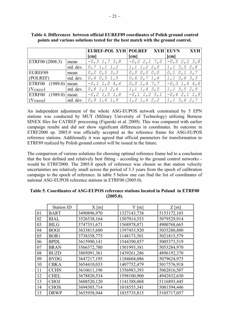
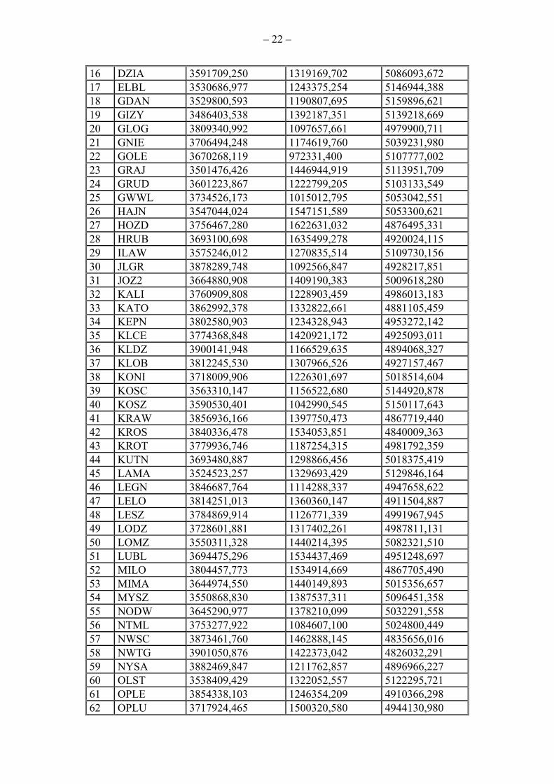
An independent adjustment of the whole ASG-EUPOS network constrained by 5 EPN stations was conducted by MUT (Military University of Technology) utilizing Bernese SINEX files for CATREF processing (Figurski et al. 2009). This was compared with earlier campaign results and did not show significant differences in coordinates. Its outcome in ETRF2000 ep. 2005.0 was officially accepted as the reference frame for ASG-EUPOS reference stations. Additionally it was agreed that official parameters for transformation to ETRF89 realized by Polish ground control will be issued in the future. The comparison of various solutions for choosing optimal reference frame led to a conclusion that the best defined and relatively best fitting - according to the ground control networks - would be ETRF2000. The 2005.0 epoch of reference was chosen so that station velocity uncertainties are relatively small across the period of 3.3 years from the epoch of calibration campaign to the epoch of reference. In table 5 below one can find the list of coordinates of national ASG-EUPOS reference stations in ETRF00 (2005.0).
Table 5. Coordinates of ASG-EUPOS reference stations located in Poland in ETRF00 (2005.0).
Station ID X [m] Y [m] Z [m]
01 BART 3490896,970 1327143,738 5153172,103 02 BIAL 3526538,164 1507014,553 5079529,914 03 BILG 3747351,671 1568978,071 4900768,665 04 BOGI 3633815,680 1397453,920 5035280,800 05 BOR1 3738358,775 1148173,501 5021815,579 06 BPDL 3615990,141 1544390,857 5005373,519 07 BRAN 3566372,780 1501993,381 5053284,970 08 BUZD 3805091,361 1439261,286 4896192,370 09 BYDG 3647217,195 1184604,086 5079624,975 10 CBKA 3654410,033 1407752,479 5017576,918 11 CCHN 3610611,196 1356983,393 5062816,507 12 CHEL 3678820,534 1598100,900 4942832,630 13 CHOJ 3608520,120 1141388,068 5116893,445 14 CHOS 3694305,714 1018555,341 5081594,446 15 DRWP 3655958,944 1035735,815 5105717,057
– 22 –
16 DZIA 3591709,250 1319169,702 5086093,672 17 ELBL 3530686,977 1243375,254 5146944,388 18 GDAN 3529800,593 1190807,695 5159896,621 19 GIZY 3486403,538 1392187,351 5139218,669 20 GLOG 3809340,992 1097657,661 4979900,711 21 GNIE 3706494,248 1174619,760 5039231,980 22 GOLE 3670268,119 972331,400 5107777,002 23 GRAJ 3501476,426 1446944,919 5113951,709 24 GRUD 3601223,867 1222799,205 5103133,549 25 GWWL 3734526,173 1015012,795 5053042,551 26 HAJN 3547044,024 1547151,589 5053300,621 27 HOZD 3756467,280 1622631,032 4876495,331 28 HRUB 3693100,698 1635499,278 4920024,115 29 ILAW 3575246,012 1270835,514 5109730,156 30 JLGR 3878289,748 1092566,847 4928217,851 31 JOZ2 3664880,908 1409190,383 5009618,280 32 KALI 3760909,808 1228903,459 4986013,183 33 KATO 3862992,378 1332822,661 4881105,459 34 KEPN 3802580,903 1234328,943 4953272,142 35 KLCE 3774368,848 1420921,172 4925093,011 36 KLDZ 3900141,948 1166529,635 4894068,327 37 KLOB 3812245,530 1307966,526 4927157,467 38 KONI 3718009,906 1226301,697 5018514,604 39 KOSC 3563310,147 1156522,680 5144920,878 40 KOSZ 3590530,401 1042990,545 5150117,643 41 KRAW 3856936,166 1397750,473 4867719,440 42 KROS 3840336,478 1534053,851 4840009,363 43 KROT 3779936,746 1187254,315 4981792,359 44 KUTN 3693480,887 1298866,456 5018375,419 45 LAMA 3524523,257 1329693,429 5129846,164 46 LEGN 3846687,764 1114288,337 4947658,622 47 LELO 3814251,013 1360360,147 4911504,887 48 LESZ 3784869,914 1126771,339 4991967,945 49 LODZ 3728601,881 1317402,261 4987811,131 50 LOMZ 3550311,328 1440214,395 5082321,510 51 LUBL 3694475,296 1534437,469 4951248,697 52 MILO 3804457,773 1534914,669 4867705,490 53 MIMA 3644974,550 1440149,893 5015356,657 54 MYSZ 3550868,830 1387537,311 5096451,358 55 NODW 3645290,977 1378210,099 5032291,558 56 NTML 3753277,922 1084607,100 5024800,449 57 NWSC 3873461,760 1462888,145 4835656,016 58 NWTG 3901050,876 1422373,042 4826032,291 59 NYSA 3882469,847 1211762,857 4896966,227 60 OLST 3538409,429 1322052,557 5122295,721 61 OPLE 3854338,103 1246354,209 4910366,298 62 OPLU 3717924,465 1500320,580 4944130,980
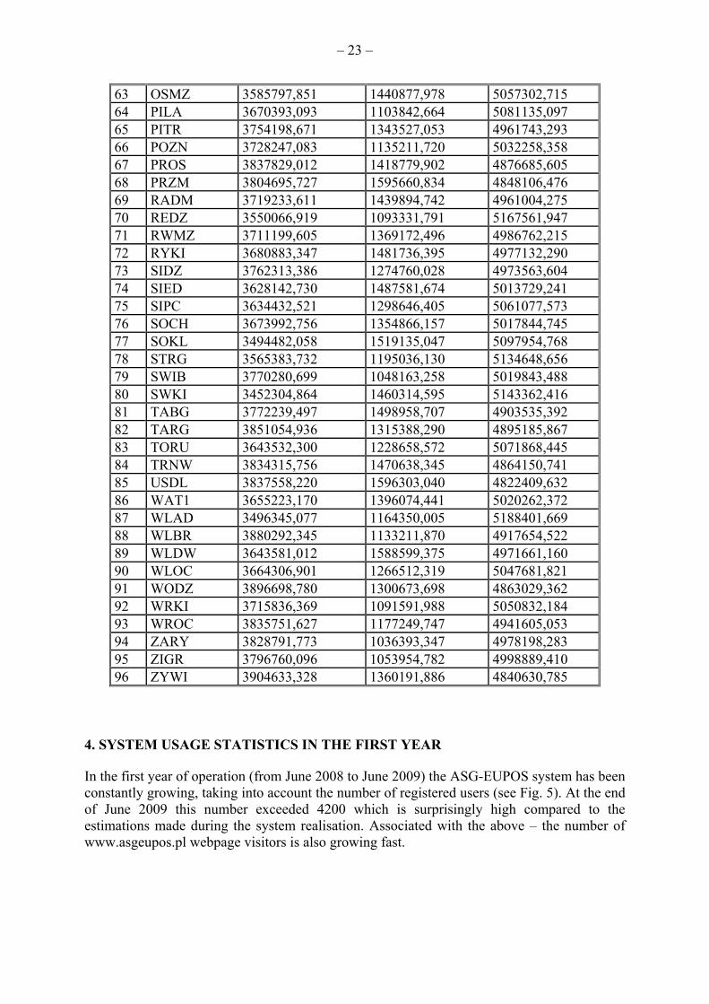
– 23 –
63 OSMZ 3585797,851 1440877,978 5057302,715 64 PILA 3670393,093 1103842,664 5081135,097 65 PITR 3754198,671 1343527,053 4961743,293 66 POZN 3728247,083 1135211,720 5032258,358 67 PROS 3837829,012 1418779,902 4876685,605 68 PRZM 3804695,727 1595660,834 4848106,476 69 RADM 3719233,611 1439894,742 4961004,275 70 REDZ 3550066,919 1093331,791 5167561,947 71 RWMZ 3711199,605 1369172,496 4986762,215 72 RYKI 3680883,347 1481736,395 4977132,290 73 SIDZ 3762313,386 1274760,028 4973563,604 74 SIED 3628142,730 1487581,674 5013729,241 75 SIPC 3634432,521 1298646,405 5061077,573 76 SOCH 3673992,756 1354866,157 5017844,745 77 SOKL 3494482,058 1519135,047 5097954,768 78 STRG 3565383,732 1195036,130 5134648,656 79 SWIB 3770280,699 1048163,258 5019843,488 80 SWKI 3452304,864 1460314,595 5143362,416 81 TABG 3772239,497 1498958,707 4903535,392 82 TARG 3851054,936 1315388,290 4895185,867 83 TORU 3643532,300 1228658,572 5071868,445 84 TRNW 3834315,756 1470638,345 4864150,741 85 USDL 3837558,220 1596303,040 4822409,632 86 WAT1 3655223,170 1396074,441 5020262,372 87 WLAD 3496345,077 1164350,005 5188401,669 88 WLBR 3880292,345 1133211,870 4917654,522 89 WLDW 3643581,012 1588599,375 4971661,160 90 WLOC 3664306,901 1266512,319 5047681,821 91 WODZ 3896698,780 1300673,698 4863029,362 92 WRKI 3715836,369 1091591,988 5050832,184 93 WROC 3835751,627 1177249,747 4941605,053 94 ZARY 3828791,773 1036393,347 4978198,283 95 ZIGR 3796760,096 1053954,782 4998889,410 96 ZYWI 3904633,328 1360191,886 4840630,785
4. SYSTEM USAGE STATISTICS IN THE FIRST YEAR In the first year of operation (from June 2008 to June 2009) the ASG-EUPOS system has been constantly growing, taking into account the number of registered users (see Fig. 5). At the end of June 2009 this number exceeded 4200 which is surprisingly high compared to the estimations made during the system realisation. Associated with the above – the number of www.asgeupos.pl webpage visitors is also growing fast.

– 24 –
Fig. 5. Number of registered users in each month. The red colour indicates total number
of system users. Only the first half year of system operation allowed to point out the areas of high interest in network corrections offered in NAWGEO service. Statistical data concerning approximate user position helped in creating a map of ASG-EUPOS services usage in Poland (Fig. 6). It is easily noticeable that GNSS surveys are concentrated in the areas of large cities as well as along large investments in roads and railways.

– 25 –
Fig. 6. The map of ASG-EUPOS system usage in Poland in 2008. The system is being mainly used by geodesists, as planned in the first period of operation, which is the reason for such imbalance of real-time services usage shown in Fig. 7. The users of other RT services – KODGIS and NAWGIS – mainly work in the field of navigation, GIS, vehicle tracking, etc.

– 26 –
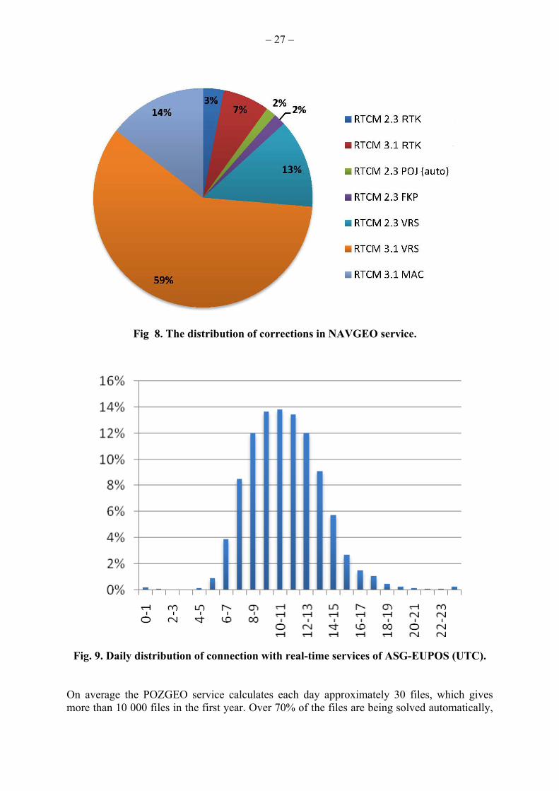
Fig. 7. The usage of ASG-EUPOS real-time services in the first year of operation. Among the NAWGEO precise corrections, the most popular are VRS network corrections in the RTCM SC 104 version 3.1 format. More than half of the users connect each day (1200 connections daily on average) to the system selecting this correction format. One should notice that RTCM 3.1 VRS corrections have not been proven to give better or more accurate results compared to other network corrections offered in the NAWGEO service portfolio. The graph presenting the distribution of corrections in NAWGEO service is shown in Fig. 8. Fig. 9 presents distribution of real-time connections during an average day. It shows the biggest concentration of measurements conducted between 7-15 h UTC.
– 27 –
Fig 8. The distribution of corrections in NAVGEO service.
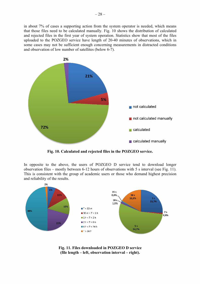
Fig. 9. Daily distribution of connection with real-time services of ASG-EUPOS (UTC). On average the POZGEO service calculates each day approximately 30 files, which gives more than 10 000 files in the first year. Over 70% of the files are being solved automatically,
– 28 –
in about 7% of cases a supporting action from the system operator is needed, which means that those files need to be calculated manually. Fig. 10 shows the distribution of calculated and rejected files in the first year of system operation. Statistics show that most of the files uploaded to the POZGEO service have length of 20-40 minutes of observations, which in some cases may not be sufficient enough concerning measurements in distracted conditions and observation of low number of satellites (below 6-7).
Fig. 10. Calculated and rejected files in the POZGEO service.
In opposite to the above, the users of POZGEO D service tend to download longer observation files – mostly between 6-12 hours of observations with 5 s interval (see Fig. 11). This is consistent with the group of academic users or those who demand highest precision and reliability of the results.
Fig. 11. Files downloaded in POZGEO D service (file length – left, observation interval – right).

– 29 –
5. CURRENT DEVELOPMENTS AND FUTURE PLANS The ASG-EUPOS system is an organism that needs constant improvements and implementation of recent technologies in order to remain competitive and useful. Currently a lot of effort is being made to more and more tailor system services to the user demands. For that, the system needs additional financing which is being searched among European Union programmes and funds. To help the users communicate better with the ASG-EUPOS administrators team and gain access to various resources associated with GNSS and ASG-EUPOS, a new, refreshed informative website has been created. It is accessible under the same address www.asgeupos.pl. Users can find there updated information on system status, its architecture and services. Additionally a user forum has been set up to allow users to exchange information concerning the system. Confronting numerous repeated problems and questions arising from ASG-EUPOS users, a list of Frequently Asked Questions has been prepared to help current and potential users in their work. The questions (FAQ) are listed on the updated website of the system (ASG-EUPOS, 2009). Current plans on system development, including densification of reference station network, transformation to partially and – eventually – fully support GLONASS and Galileo GNSS signals, further development and utilization of meteorological sensors collocated with GNSS receivers, supporting institutional users with dedicated services, are being transformed into project proposals and sufficient funding is being looked for. Additionally, a second stage of the calibration campaign is being started, including establishing of accessory points for reference stations to enable vertical measurements with classical methods to the stations. 6. CONLUSIONS Establishment of the ASG-EUPOS system enabled users in various sectors of Polish economy, to precisely and efficiently determine their spatial position. The uniformity of the system gives new opportunities, so far not accessible to the users. This is one of the reasons, why ASG-EUPOS system gained such a large number of customers in a relatively short time period. But the system needs constant evolution to fulfil the demands in the future. Current projects prepared by the Head Office of Geodesy and Cartography aim at further development of the system. BIBLIOGRAPHY
1. Bosy J., Graszka W., Leończyk M. (2007), ASG-EUPOS - A multifunctional precise satellite positioning system in Poland, European Journal of Navigation, vol. 5 (4) September 2007, pp. 2-6
2. Bosy J., Oruba A., Graszka W., Leończyk M., Ryczywolski M. (2008), ASG-EUPOS densification of EPN on the territory of Poland, EUREF 2008 Symposium, Brussels, Belgium, 12-21 June 2008
3. Szafranek K., Figurski M., Kamiński P., Kroszczyński K. (2009) ASG-EUPOS Monitoring with reference to EPN, EUREF 2009 Symposium, Florence, Italy, 27-30 May 2009

– 30 –
4. Graszka W. (2007), Wielofunkcyjny system precyzyjnego pozycjonowania satelitarnego ASG-EUPOS (Multifunctional precise satellite positioning system ASG-EUPOS), Geodeta, Geoinformational Magazine, vol. 2 (141), Feb. 2007, pp. 4-8
5. Graszka W., Leończyk M., Oruba A. (2009), Implementation of ASG-EUPOS within national control network, EUREF 2009 Symposium, Florence, Italy, 27-30 May 2009
6. Kryński J., Figurski M. (2006) , Results of re-processing of GPS data from EUREF-POL, POLREF and EUVN campaigns using EPN standards, Symposium of the IAG Subcommission for Europe, Riga, Latvia, 14-17 June 2006
7. Somla J., Wajda S., Oruba A., Ryczywolski M., Leończyk M., Bosy J. (2008), ASG-EUPOS w fazie testów (ASG-EUPOS testing in progress), Geodeta, Geoinformational Magazine, vol. 2. (153), Feb. 2008, pp. 4-8 (NAWI)
8. ASG-EUPOS (2009), Information about the ASG-EUPOS system, September 2009, http://www.asgeupos.pl/
9. GUGiK (2005), Technical project of multifunctional precise satellite positioning system ASG-EUPOS in Poland, Head Office of Geodesy and Cartography, 2005
10. PAS SRC (2008), Testing of reference stations and operative ASG-EUPOS system – report, Polish Academy of Sciences – Space Research Centre, 2008