Embed Size (px)
Citation preview

Environmental and Social Impact Assessment (Draft) Project Number: 47929 September 2013
PAK: Gulpur Hydropower Project Prepared by Mira Power Limited
The environment and social compliance audit report is a document of the borrower. The views expressed herein do not necessarily represent those of ADB's Board of Directors, Management, or staff, and may be preliminary in nature. Your attention is directed to the “Term of Use” section of this website.

ESIA of 100MW Gulpur Hydropower Project (GHPP) Kotli, Azad Jammu and Kashmir
| P a g e
September 20, 2013
Kotli, Azad Jammu and Kashmir - Pakistan
Environmental and Social
Impact Assessment (ESIA)
and
Environmental and Social
Management and
Monitoring Plan (ESMMP)
100MW Gulpur Hydropower Project
Ref: D3V01ESIA

ESIA of 100MW Gulpur Hydropower Project (GHPP) Kotli, Azad Jammu and Kashmir
Environmental and Social Impact Assessment (ESIA) and
Environmental and Social Management and
Monitoring Plan (ESMMP)
of
100MW Gulpur Hydropower Project
Kotli, Azad Jammu and Kashmir, Pakistan
September, 2013

ESIA of 100MW Gulpur Hydropower Project (GHPP) Kotli, Azad Jammu and Kashmir
Environmental and
Social Impact
Assessment (ESIA)
Volume 1
100MW Gulpur Hydropower Project
Kotli, Azad Jammu and Kashmir - Pakistan

ESIA of 100MW Gulpur Hydropower Project (GHPP) Kotli, Azad Jammu and Kashmir
Environmental and Social Impact Assessment (ESIA)
of
100MW Gulpur Hydropower Project
Kotli, Azad Jammu and Kashmir, Pakistan
Volume 1
September, 2013

ESIA of 100MW Gulpur Hydropower Project (GHPP) Kotli, Azad Jammu and Kashmir
i
LIST OF ACRONYMS
ADB Asian Development Bank
AJK Azad Jammu & Kashmir
AJK-EPA Azad Jammu & Kashmir Environmental Protection Agency
AJK-EPC Azad Jammu & Kashmir Environmental Protection Council
AJK-HEB Azad Jammu & Kashmir Hydro Electric Board
BACT Best Available Control Technology
BOD Biochemical Oxygen Demand
BOOT Build, Own, Operate and Transfer
BP Bank Procedures
BPEO Best Environmental Practicable Option
CBD Convention on Biological Diversity
CCGT Combined Cycle Gas Turbine
CDM Clean Development Mechanism
CEMP Construction Environmental Management Plan
CEO Chief Executive Officer
CFC Chlorofluorocarbon
cfu Colony Forming Unit
CITES Convention on International Trade in Endangered Species
CMP construction management plan
CMS Conservation of Migratory Species
COD Chemical oxygen demand
COO Chief Operating Officer
CSC Construction Supervision Contractor
CSR Corporate social responsibility
Cumecs Cubic Meter per Second
DHQ District Headquarter
EHS Environment, Health and Safety
EIA Environmental Impact Assessment
El. Elevation
EMMP Environmental Management and Monitoring Plan
EOS Earth Observing System
EOSDIS Earth Observing System Data and Information System
EPA Environmental Protection Agency
EPC Environmental Protection Council
EPC Engineering, Procurement and Construction
EPRRP Emergency Preparedness, Response and Recovery Plan
ER Encounter Rate
ESIA Environmental and Social Impact Assessment
ESMMP Environmental and Social Management and Monitoring Plan
FAP First Aid Post
FCCC Framework Convention on Climate Change

ESIA of 100MW Gulpur Hydropower Project (GHPP) Kotli, Azad Jammu and Kashmir
ii
FGDs Focused Group Discussions
GCP Ground Control Points
GHG Green House Gas
GHPP Gulpur Hydropower Project
GIIP Good International Industry Practice
GIS Geo Information System
GoP Government of Pakistan
GWh Gigawatt Hour
HCFC Hydro Chlorofluorocarbon
HSE Health Safety Equipment/ Health, Safety and Environment
IDC Indirect Costs
IEE Initial Environment Examination
IFC International Finance Cooperation
IP Indigenous Peoples
IPP Independent Power Producer
IR Involuntary Resettlement
IUCN International Union for Conservation of Nature
KDA Kotli Development Authority
KOSEP Korea South East Power Company
LAA Land Acquisition Act
LAC Land Acquisition Collector
LARP Land Acquisition and Resettlement Plan
LDL Lowest Detection Limit
LOI Letter of Interest
LOS Letter of Service
LPDAAC Land Processes Distributed Active Archive Center
LPG Liquid Petroleum Gas
M&E Maintenance and Engineering
MAF Million Acre-Foot
MCH Mother Child Health Care
MCM Million Cubic Meters
MPL Mira Power Limited
MSDS Material Safety Data Sheet
MW Megawatt
NASA National Aeronautics and Space Administration’s
NCS National Conservation Strategy
NDVI normalized difference vegetation index
NEQS National Environmental Quality Standards
NESPAK National Engineering Services Pakistan
NOC No Objection Certificate
NOL Normal Operation Level
OM Operations Manual
OP Operational Policy
PIC Prior Informed Consent

ESIA of 100MW Gulpur Hydropower Project (GHPP) Kotli, Azad Jammu and Kashmir
iii
PM Particulate Matter/Project Manager
PPE Personal Protective Equipment
PPIB Private Power & Infrastructure Board
PS Performance Standard
PWD Population Welfare Department
RCC Reinforced Cement Concrete
SCP Spill Contingency Plan
SPA Share Purchase Agreement
SPS Safeguard Policy Statement
SR Safeguards Requirement
SSC Species Survival Commission
TBT Tool Box Talks
TDS Total Dissolved Solids
TNTC Too Numerous to Count
USBR United States Bureau of Reclamation
WAPDA Water and Power Development Authority
WCMC World Conservation and Monitoring Centre
WWF World Wildlife Fund

ESIA of 100MW Gulpur Hydropower Project (GHPP) Kotli, Azad Jammu and Kashmir
iv
EXECUTIVE SUMMARY
Today Pakistan is facing multifarious problems and challenges. These challenges are not a product of
sudden incident; rather it is a cumulative outcome of lack of planning and misplaced priorities of the
state. Among these challenges, energy crises is the acute one as it is energy that derives the engine
of economy and overall functions of modern economic order. The power sector in Pakistan has been
facing shortages of electricity generating capacity due to low pace of development of new power
plants to meet the growing demand for electricity. This has been aggravated by the rising price of oil,
shortage of natural gas and lesser focus on hydropower development. The effect of the large gap
between demand and supply of electric power has led to massive load shedding in Pakistan and in
Azad Jammu and Kashmir. Due to the widening of this gap, all walks of life from industry to domestic
are being adversely affected.
The primary cause for this worse energy crisis among others is the expensive energy mix which is
predominantly fossil fuel based resulting heavy dependency on expensive oil imports and depleting
natural gas reserves. For the long term energy security of the country and to ensure sustainable
development of the country, hydropower development is considered as the most feasible option,
which is in abundance in Pakistan. Development of hydropower is also considered as attractive to
help improving the management of the national water resources which supports one of the largest
irrigation systems in the world, upon which agriculture of the country is heavily dependent. Given
the gravity of situation in energy sector and opportunities it provides for private sector to invest, a
100 MW Hydropower Project in Gulpur on the Poonch River is proposed by the Private Power &
Infrastructure Board (PPIB).
This study assesses the environmental and social impacts associated with the construction and
operation of the Gulpur Hydropower Project. The Environmental Social Impact Assessment (ESIA)
was performed in four main phases of scoping, baseline data collection, impact assessment and
documentation. Scoping phase entails project data compilations, review of published literature,
legislative review and identification of potential impacts. While preparing the report great attention
is paid to ensure that the ESIA process and results are prepared according to the relevant guidelines
set by the Environmental Protection Agency (EPA), ADB and IFC.
Policy, Legal and Administrative Framework
Any development initiative specially related to hydropower has to take into consideration the legal
responsibilities of the proponent in the context of the environment and sustainable development,
and the requirements of the institutions that may influence the environmental management of the
proposed project. The Pakistan National Conservation Strategy (NCS) that was approved by the
federal cabinet in March 1992 is the principal policy document on environmental issues in the
country as well as AJK (EUAD/IUCN, 1992). The core areas that are relevant in the context of the
proposed project are pollution prevention and abatement, restoration of rangelands, increasing
energy efficiency, conserving biodiversity, supporting forestry and plantations, and the preservation
of cultural heritage. The Government of Pakistan promulgated “Pakistan Environmental Protection
Act” in 1997. The same was adopted by the Government of AJK. However, this act was adapted to
meet the state’s requirements and notified in 2000 as Azad Jammu and Kashmir Environmental

ESIA of 100MW Gulpur Hydropower Project (GHPP) Kotli, Azad Jammu and Kashmir
v
Protection Act, 2000. Environmental Protection Agency headed by a Director General has the
responsibility for establishing Biodiversity Action Plan at a country level.
Under Section 11 of the 2000 Act, a project falling under any category (qualifying IEE or EIA) requires
the proponent to file IEE or EIA with the AJK-EPA. In the absence of AJK-EPA guidelines for
environmental assessment, those laid down by Pak- EPA have been followed. The Pak-EPA has
published a set of environmental guidelines for conducting environmental assessments and the
environmental management of different types of development projects. Other important policy
documents and legal requirements of the project are: National Environmental Quality Standards
(NEQS), National Resettlement Policy and Ordinance, The Land Acquisition Act, 1894, The Forest Act,
1927 and the Forest (Amendment) Act 2010, The Jammu and Kashmir Forest Regulations, 1930, The
AJK Wildlife (Protection, Preservation, Conservation and Management) Act, 1975, Azad Jammu and
Kashmir, Wildlife (Protection, Preservation, Conservation and Management) Ordinance, 2012, The
Antiquities Act, 1975, The Motor Vehicles Ordinance, 1965, and Rules, 1969, The Factories Act, 1934,
The Pakistan Penal Code, 1860, The Explosives Act, 1884
Owing to its magnitude the proposed project involves various stakeholders and institutions.
Therefore, it is indispensable to interaction with different agencies. This engagement will ensure
that the project complies with the laws and regulations controlling the environmental concerns of
dam construction and operation, and that all pre- construction requisites, such as permits and
clearances are met. Besides providing overview of Policy, Legal and Administrative Framework, the
section 2 also adumbrates guidelines of Asian Development Bank and requirements of IFC related to
the Project.
Project Description
The Gulpur Hydropower Project site is administratively located in Kotli District of Azad Jammu and
Kashmir. It is located at latitude 33°27’ and longitude 73°51’, which is about 5 km South of Kotli
Town. The site is approximately 167 km from Islamabad and 285 km from Lahore, and is accessible
directly from Islamabad and Lahore by a two-lane (and partially paved) mountainous road. The
proposed Gulpur Hydropower Project will exploit the water resources of the Poonch River for power
generation. It will comprise four main components, viz., Weir, Intake Structure, Power Tunnel and
Power House. The Weir will be located near Aghar Colony on the Poonch River at about 5 km
downstream of Kotli Town and about 250 m downstream of the confluence of Ban Nullah with the
river. The Intake Structure and intake portal of the Power Tunnel will be located on Ban Nullah about
2 km upstream of its confluence with the Poonch River. The Power House and outlet portal of the
Power Tunnel will be located on Poonch River about 6.5 km downstream of the Weir structure.
Land Acquisition requirements of the Project are directly related to the consideration of design
alternative to construct the earthen Dyke in the submerged area. The proponent has carried out
detailed analysis of land requirements and resettlement requirement under following the two
options. Under Option 1 an earthen Dyke shall be constructed in the submerged area to curtail the
land acquisition and land resettlement while under Option 2 “No Dyke” was proposed. Under the
selected Option 2 Under “No Dyke” option the project will consume 13% (113 Acres) of the total
area for building structures, reservoir, colony, and camp and approach roads. About 87 percent (804
Acres) of the land required for the proposed project will be utilized for the reservoir. In total the

ESIA of 100MW Gulpur Hydropower Project (GHPP) Kotli, Azad Jammu and Kashmir
vi
proposed project will required 920 Acres of land; major portion (74 percent) of this land is owned by
the Government while only 26 percent land in privately owned.
A 2-stage river diversion plan has been proposed for the construction of the Weir. The diversion will
be manipulated within the river section by constructing coffer dams. It is anticipated that the Project
would take about 45 months for its completion and commissioning.
It has been estimated that the project will employ about 700 skilled, semi-skilled and unskilled
workforces for its construction and commissioning. Majority of unskilled and to some extent semi-
skilled and skilled workforce will be employed from the local area. However, the contractor will
engage specialized workforce including engineers, geologists and construction management staff
from the outside area. The project falls in a terrain that is constituted of high hills having steep
slopes with narrow valleys in between. The contractor would need to develop access roads for all
the sites. The section on project description provides plan of alternative and access roads. The
Project will deploy various types of machineries for construction purposes. These will include
bulldozers, excavators, shovels, tunneling machine, dumpers, batching plant, tankers, trucks, etc.
The project cost will be approximately US$ 340.00 million.
Description of the Physical Environment
Baseline data on physical environment within the area of project influence has been compiled to
cover these areas: land, climate and meteorology, water (water resources, water quality, source of
pollution and hydrology and air Quality and Noise (noise levels). Some of these areas are directly
affected while others may be influenced indirectly. This section highlights the areas of most
concerns. Most of the potentially affected areas, except the ones related with the quarries, would
fall within a strip of about 4 km wide (on the average 2 km on either side of the Poonch River) and
about 10 km in length covering the river stretch from Kotli up to the Power House site.
The study area is a part of land formations developed at the foothills of Himalayan Ranges through
tectonic events subsequent to those that caused building of Himalaya. The Project area contains
middle Siwalik formations developed from the sedimentary deposits contributed by a number of
drainage channels from the uprising Himalayan Mountain Ranges. The rock formations include
extremely folded beds, having almost vertical dips, of various types of sandstones, clay-stones and
siltstones. Mostly the mountains are covered with primary soils, except along the river and nullahs
where the beds are almost devoid of soil material.
Major geological formations in the project area are; Pleistocene and Recent Deposits Overburden,
Secree, Talus and Vegetation, Classification of Rocks, Sandstone, and Clay stone/Siltstone. The
project area lies very close to the Riasi Thrust which is a branch of the Main Boundary Thrust (MBT).
Virtually, the former almost passes through or near to the course of the Poonch River, while the
latter bounds the Project area at a distance of about 5 km towards east. Consequently, the proposed
Project will be located in active seismic region that has experienced few large earthquakes with
magnitude greater than 7.
The towns of Poonch, Sehra, Tatta Pani and Kotli are situated on the banks of this river. It has two
major tributaries in Pakistan, Batar and Mendher. The Poonch River originates at an elevation of
more than 3500 m and traverses about 110 km from east to west up to the proposed weir site and

ESIA of 100MW Gulpur Hydropower Project (GHPP) Kotli, Azad Jammu and Kashmir
vii
fed by many big and small streams on both the banks. Most of the tributaries join the river on its
right bank. The relief in the catchment area of Poonch River varies from 200 m to 4500 m. This
elevation range was divided into 9 elevation bands with 500 m interval.
The texture of the primary soils varies from moderately fine to moderately coarse depending upon
the rock type from which these have developed. However, the secondary soils are mostly
moderately coarse textured. The soils of the raised terraces in floodplains are generally devoid of the
stony material. The soils of lower terraces generally contain varied quantities of pebbles, cobbles
and boulders.
Generally, the project area falls in sub-humid and sub-tropical zone. It has moderate summer and
cold winter. The climate is greatly influenced by monsoon in the months of July and August and
snowcapped mountains of Pir Panjal Range. The average annual precipitation in the area is 1,237
mm. Temperature in different parts of the tract varies according to the elevation. The data shows
that the average monthly mean maximum temperature varies from 17.6 °C in January to 38.4 °C in
June, whereas monthly mean minimum temperature ranges between 4.8 °C in January and 24.9 °C in
June.
Mean monthly discharges computed from the mean daily flows shows a minimum value of 12
cumecs observed in January 1966 and maximum value of 830 cumecs in September 1992. The data
depicts that mean monthly flows vary between 41 cumecs (106 MCM) in November to 279 cumecs
(746 MCM) in August.
Main water resources in the district Kotli are surface water and ground water. The microbiological
analysis of the water sample in the project area show that nearly every sample has some biological
contamination. Especially the drinking water in Jamal Pur and Aghar Colony has highest microbial
count. The analysis shows that hardness in all the samples ranged from 346 to 515 mg/l. Total
hardness of water as CaCO3 is within acceptable limits in most of the samples except for one.
No air quality monitoring data is available for the project area. In general there are no major sources
of air pollution, viz., industries, exist in the project area except road traffic in the valleys of Poonch
River and Nullahs. The ambient particulate matter PM10 was found 97.14 ug/m3 at proposed power
house site, 87.90 ug/m3 at proposed camp area, 75.19 ug/m3 at proposed weir site and 66.77ug/m3
at proposed batching plant are within standard value of 150 ug/m3.
The noise level was found in range of 59.7 to 68.1 (dBA) at proposed power house site, 37.0 to 57.0
(dBA) at proposed camp site, 37.3 to 54.8 (dBA) at proposed weir site and 35.9 to 48.9 (dBA) at
proposed batching plant.
Description of Biological Environment
The biological component of the study focused on the aquatic ecology, flora, mammals, birds, and
reptiles and amphibians. The forests of the area are characterized by the presence of subtropical
broad leaved vegetation and are fundamentally Chirpine forest type. These forests are mainly
dominated by Pinus roxburghii in an altitudinal range of 700-1800m. The sub-tropical forests of the
area were mainly dominated by Pinus roxburghii. But present figures show that Pinus-Themeda
community is becoming sparse which would eventually transform the area into a degraded scrub-

ESIA of 100MW Gulpur Hydropower Project (GHPP) Kotli, Azad Jammu and Kashmir
viii
land. Now, the area is characterized by the dominance of herb and shrub layer, comprising Themeda
anathera, Poa annua, Carissa opaca and Adhatoda vasica over Pinus roxburghii.
Most of the population of the area dwells in remote areas that are not easily accessible and thus left
with no other option but to rely on medicinal plants for general treatment. Notable among these
floras are Justicia adhatoda, Acacia nilotica, Calotropis procera, Ricinus communis, Morus nigra,
Dodonaea viscosa, Achyranthes aspera, Ipomoea carnea, Taraxacum officinale, Eriobotrya japonica,
Cissus carnosa, Melia azedarach, Eucalyptus citriodora and Ficus carica.
The data shows that these forests are faced with the problems of overgrazing and deforestation.
Regarding floral Diversity that a total of 186 vascular plant species were identified from the area
including 3 species of pteridophytes. The Leguminosae and Asteraceae were the largest families of
dicotyledons, whereas, Poaceae was largest of the monocotyledons. Biogeographically the area of
the Project falls into Irano-Turanian region Floristic region. The Himalayan endemics included 19
species, whose details are provided in the section. Among the rare species Fraxinus raiboearpa was
the plant that is confined to few localities in north Pakistan and Afghanistan. None of the species
found in GHPP study area is listed in the WCMC list in endangered categories.
The project area lies in the humid subtropical zone influenced by monsoon Mediterranean
disturbances as well. The forests can be grouped into and Subtropical Broadleaved Forest, and
Subtropical Pine Forests. The dominant land use at the project facilities will be
agriculture/settlements. Areas devoid of forest make about 25% of the land cover. Overall forest
cover is only 18 % that can be treated to be closest to primary; otherwise, the forest cover is not so
dense. Similarly for the direct impact areas (project facilities) the forest cover is around 35% with
only about 5% being dense.
River Poonch is generally rich in fish diversity and even 21 fish species have been recorded from a
stretch of about 10 km. This diversity is quite high for this small river stretch. Among the recorded
species, majority of fish fauna belongs to the family Cyprinidae which is comprised of 13 species.
Other 8 species are divided among seven families in such a way that five families are represented
only by one species and the rest two each by two species. Among the fish fauna of the project area,
two species are endemic in Pakistan including AJK, one is endangered, two are Vulnerable, and one
is Near Threatened. Quite a good number of species are commercially important. The species Tor
putitora and Clupisoma garua are considered among the esteemed fishes and have very high
commercial value.
The Project is located in the “Mahasher National Park” which was notified recently to protect the
Endangered Mahasher Fish (Tor putitora). The national park through relevant legislation restricts
various forms of species exploitation to ensure that the habitat remains pristine and congenial for
the indigenous species.
Thirty one families of macro-invertebrates were identified from 546 benthic macro-invertebrate
individuals collected during the whole study period. A number of mammalian species including
common leopard, black bear, barking deer, jackal, fox and rhesus monkey were reported from the
Kotli district of Azad Jammu and Kashmir in past. In order to assess human-wildlife interaction and
site two surveys were carried out. Jackal has highest annual sighting rate at 25 animals per

ESIA of 100MW Gulpur Hydropower Project (GHPP) Kotli, Azad Jammu and Kashmir
ix
respondent per year followed by fox; 4.7, and rhesus monkey; 2.8. Black bear, leopard cat and wild
boar have negligible sighting rates.
Only 12 cases of predation on livestock and poultry were recorded. Jackal was the main predator
responsible for almost 92% predations majority; 93%, of which was poultry while remaining were
goats. Goats were killed while grazing and poultry was capture from cage most of the time. Only one
case of common leopard depredation was reported in which predator attacked on a coral and killed
30 goats at a time.
Seventeen species of small mammals have been collected from the study area belonging to eleven
families and five orders. Among reptiles snakes and frogs of different are found in the area. Manzoor
et al. (2013) while assessing the biodiversity of the Pir Lasura National Park in District Kotli, Azad
Kashmir reported six amphibian and 24 reptilian species. No crocodilians and tortoises are found in
the study area; Kotli, AJK and the existing species in the study area include; freshwater turtles,
lizards and snakes. Some of the reptilian species are nocturnal in their feeding habits like gekkonid
lizards and elapide snakes whereas others are diurnal like agamid, lacertid, varanid and scincid
lizards, freshwater turtles and colubrine snakes. A number of surveys were carried out which
includes reptile and amphibian diversity survey. Total 21 species of herps including six amphibians
and 15 reptiles were recorded during the present study.
Analysis of data on residential status revealed that out of 61 bird’s species, 76% were year round
resident, remaining were summer breeders, winter visitors and passage migrant. In term of the
abundance of recorded species, the undisturbed area depicted the higher diversity of avian fauna.
The Habitat destruction, anthropogenic pressure in the form of tree cutting, firewood collection,
grass cutting, and cattle grazing were also observed in these study sites. Out of 21 species found in
Poonch River, 12 species are species of special importance. This section on Baseline Ecology provides
lists of the species.
Socio-Economic Environment
This section presents a description of the socioeconomic characteristics of the project area, and
where available utilizes national and regional level data for providing a more cogent understanding
of the context. Socio-economic survey in the project area covered 8 villages/settlements namely 1)
Aghar, 2) Barali, 3) Dharang and 4) Gulharin, 5) Hill Kalan, 6) Hill Khurd, 7) Jamal Pur and 8) Mandi.
The district Kotli is the second largest in terms of population in Azad Jammu and Kashmir. The
population of the district was 365,000 in 1981 and an increase of 54.37 percent was recorded over
the last seventeen (17) years i.e 1981-1998. The human habitation in district Kotli is predominantly
determined by its topography as the hilly mountainous terrain limits options for human habitation.
Hence, most of the human habitation in the project area is scattered.
Traditionally, the social set up of Kotli was largely based on kinship. The overall social arrangement
was based around different clans (baraderi). In the decades of 1960-70s migration of people to
abroad for earning shifted the basis of economy. With increasing exposure to market forces and
exogenous lifestyle the pattern of interface between different communities also witnessed drastic
changes. Despite modernization people still rely on pre-modernization social structure and social

ESIA of 100MW Gulpur Hydropower Project (GHPP) Kotli, Azad Jammu and Kashmir
x
interaction and politics is largely shaped by social dynamics and power relationships. However,
access of opportunities in the country and abroad enabled people to find increasing role in the
society. The major tribes residing in the district are Syed, Gujar, Jat, Rajput, Awan and Sudhan.
Hindko, Gojri and Pahari are the indigenous languages of the district.
Generally the area is peaceful as there are no chronic social and communal conflicts among the
communities living in the project area. Major crops are maize, wheat & rice whereas minor crops
include vegetables, grams, pulses (red lobia) and oil-seeds. Major fruits are apple, pears, apricot and
walnuts. The main economic activity in area remains in agriculture, livestock and service sectors. Of
the total land area of about 414,019 acres of Kotli District, 20% is available for cultivation while 80%
of the land bears forest, settlements, infrastructures or lie in the form of uncultivable waste land.
The survey results show that 11% of the male workforce is comprised of unskilled laborers, whereas
no female works as a laborer.
According to the information received from Department of Education AJK, apart from a campus of
University of Azad Jammu and Kashmir there is one post graduate college for men and 12 degree
colleges for men and women in the district. In the project area each settlement has primary level
government schools for boys and girls within an average distance of 2 km. Overall 27% of the
population falling above the eligible age of 10 years population is illiterate (20% men and 36%
women). Population Health Profile
There is one District Headquarter (DHQ) Hospital in District Kotli, three Rural Health centers, 20 First
Aid Posts (FAPs) and 16 Mother Child Health Care (MCH) Centers along with other health facilities at
grassroots level. The housing pattern is lavish in terms of size and construction as more than 88% of
the structures are pukka, made of cement and bricks with RCC structures. According to Government
of AJK, currently 80% of the urban population and 66% of rural population has been provided with a
piped water supply through house connections and public stands. The entire population (95%) in the
project area has access to drinking water in their houses. 23% use water from wells and 50% use
water from both wells and pipeline. 32% have facility of sewerage system, and 57% use septic tank.
7% percent use a pit latrine and 4% use open fields. The majority of households do not have
drainage facility (68%).
Electricity connection is available to all the households (100%) in the project area. The women have
no formal role in the authority structure of the nearby villages. They are about 48% of the
population in these villages; the literacy rate for above 10 years of female population is 67% (80% for
males). There is none falling under the category of ultra-poor as all the households have a monthly
income which is above PKR 5,000/- and expenditure accordingly. There are some shrines of saints.
Analysis of Alternatives
Alternatives are essentially, different ways through which the proponent can feasibly achieve
sustainable development by carrying out a different type of actions, choosing design alternatives or
adopting a different technology or design for the Project to create win-win scenario for all
stakeholders. Alternatives and mitigation, therefore, cover a spectrum ranging from a high level to
very detailed aspects of project design. This section of the report presents the analysis of the
alternatives considered for the proposed project. The different alternative proposed are: no project

ESIA of 100MW Gulpur Hydropower Project (GHPP) Kotli, Azad Jammu and Kashmir
xi
scenario, alternate methods of power generation, alternate location of the Project, design
alternatives and selection of access roads and alignment.
The “No Project” option is least considered option for Pakistan. The country is currently going
through the worse power crisis of the history. Energy crisis is considered as major development
hurdle in Pakistan and has resulted in massive load shedding in the country hugely deteriorating the
economic development and growth. In year 2012-13 reveal that the power shortfall touched the
figured of 6,390 MW with average shortfall of 3,886 MW. The total generation was 95,364 GWh
during year 2011-12 which represent only 47% capacity utilization. “No Project” scenario is
considered or adopted it would mean that the already power deficient economy would suffer even
more and at current rate if no power is added to the national grid. Given the gravity of energy crisis
and its repercussion on the economy, Pakistan cannot afford to deprive itself of a major project of
cheap source of electricity
There are different options available to generate electricity which include but are not limited to
production using furnace oil, natural gas, coal, solar and hydel. Out of total 95,364 GWh produced
during year 2011-12, only 30% has been generated by Hydel resources, 29% has been produced
using natural gas while the 35% generation was dependable on expensive furnace oil. The nuclear
energy contributed 5.5%, whereas a minor part of energy also came through diesel and coal.
Non-renewable options such as solar and wind are not brought into the national grid at any of the
location in Pakistan, however, few wind projects are at different stages of implementation/
construction. Pakistan imports oil from other countries to meet domestic needs whilst the gas
reserves of the country are fast depleting and hence cannot be presently considered as reliable
sources of power generation. The only coal used in Pakistan is imported from Indonesia and South
Africa. The Thar Coal resources are still in early stages of exploration and are yet to be further
evaluated for potential to generate electricity. Wind power is currently in the experimental stage
and few projects are under implementation and having lower efficiency and power potential cannot
be considered as a replacement or full time substitute of other sources of power generation.
Numerous perennial and seasonal rivers are flowing in the north south direction in Pakistan. Hence
Hydel power is considered a viable option for a country rich in surface water resources. For a
developing country like Pakistan minimum O&M cost makes the hydel power as a viable option.
Hydropower is the cheapest source of electricity in terms of per unit cost and maintenance of the
generation system when compared with other alternatives, such as the furnace oil or gas run power
plants. Hydropower requires significant initial investment compared with thermal options, however,
once the debts are paid back the cost of electricity generation reduces significantly resulting in long
term energy security of the country. A typical hydropower project in private sector has a levelized
cost around 8-9 US cents/KWh with a generation cost of about 3 US cents/KWh after debt
repayments are complete. In comparison the thermal projects (furnace oil based) currently have the
levelized cost of around 16.0 US cents/KWh and keep on increasing with time due to continuous
increase in oil prices.
In Pakistan the hydro power plants have a plant load factor in the tune of 50% - 60% which is slightly
lesser than that for conventional power generation sources with higher load factor of 60% - 80%.
However, it is higher than those of other renewable energy options such as wind and wave energy.

ESIA of 100MW Gulpur Hydropower Project (GHPP) Kotli, Azad Jammu and Kashmir
xii
The proposed project is located in a greener area where installation of a combustion based power
plant would only deteriorate the environment, while installation of hydro power station would not
have any greenhouse emissions from plant operations and the positive economic impact would help
reduce the pressure on the local natural resources. It is obvious that hydro power plants are the
lowest ranked in terms of greenhouse emissions into the environment while the coal power plants
are the most notorious when it comes to greenhouse gas emissions.
Series of technical feasibility studies have been carried out for the analysis of the optimum location
for the construction of the dam at Gulpur. Two alternative options were considered for possible
Poonch River development in two main combinations. Combination-A comprised four sites, which
include Sehra, Kotli, Barali and Rajdhani dam sites whereas Combination-B consisted of three sites
namely Sehra, Kotli and Gulpur dam sites. Further studies concluded that a new site, which is located
near Gulpur Village approximately 7 Km downstream of the Barali dam site which was different from
the earlier identified Gulpur site. During the initial stages of the feasibility study, it was noticed that
the reservoir level (El 475 m) of proposed Rajdhani Hydropower Project would submerge the newly
identified Gulpur site; therefore the site was shifted to an upstream location above the reservoir
level of Rajdhani Hydropower Project. During design stage, several locations were examined to find a
suitable site where a high storage dam could be built to maximize the power potential and final site
location will ensure that the Kotli and Rajdhani Dam can also be constructed along with the Gulpur
Dam. To ensure the natural and social environment are not disturbed numerous tweak in the design
are included.
During the finalization of the feasibility study of the Project Consultants initially recommended the
normal operating level (NOL) of reservoir at El. 550 m. The Project layout involved submergence of
about 646 houses and 1800 acres of inhabited area affecting nearly 5,000 people. In an effort to
reduce the environmental and social impacts three options were Option 1 was based on the earlier
concept where a 75m high dam with NOL at El. 550 m and an underground powerhouse was
proposed. Option 2 was essentially Option-1 but with a reduced dam height of 60 m and NOL at El.
535 m. Option 3 was based on the concept wherein the head is partly created by a weir and partly by
a tunnel utilizing the steep gradient of the river. Following the selection of Option 3 as the most
viable option, further design optimization and studies were based on such option under which
maximum reservoir level was fixed at El. 540.0 m to avoid submergence of surrounding villages and
Project was conceived as run-of river with small storage. In an effort to further curtail the
resettlement and minimizing environmental impacts for selected Option 3 (as explained above)
different options were further studied and it is proposed to build Earthen Protection dyke, Collection
Drain with Dewatering Arrangement were proposed in the expected resettlement area.
The EPC Contractor initially proposed the construction of temporary facilities and access roads at
those locations which were resulting in high resettlement in terms of houses, cultivable land and
other infrastructure and also having negative environmental impacts. The proponent and EPC
Contractor deliberated extensively on this matter to find the engineering solution which results in
lesser resettlement and lesser environmental impacts.

ESIA of 100MW Gulpur Hydropower Project (GHPP) Kotli, Azad Jammu and Kashmir
xiii
Stakeholder Consultations
Apart from gathering of quantitative data through household survey of the area of influence of the
project and 100% survey of project affected people a total of 16 consultations (qualitative) were
conducted with the affected persons and other local community to share the information about the
project and record their concerns/ feedback associated with this project. The consultation was in
two stages of scoping and stakeholder’s consultation. Consultative sessions discussed the topics
related to land acquisition and resettlement issues, employment and livelihoods of communities,
gender and women issues, contractor’s camp and access and environmental issues.
The section of stakeholder consultations provides details of outcomes of consultations and covers
issues and concerns showed by the stakeholders regarding land acquisition and resettlement. To
address the issues and concerns raised by the stakeholders a mitigation plan has been developed
and made part of the ESIA. The stakeholders supported the Gulpur Hydro Power project provided
that environmental and issues are addressed through mitigation measures. To address the issues an
ESIA and Land Acquisition and Resettlement Plan (LARP) are developed and shared with
stakeholders for their feedback and suggestions.
Impact Assessment and Mitigation
Environmental impacts have been and will continue to be considered, eliminated or reduced
throughout the lifecycle of the Project. The prediction and evaluation of impacts of the Project has
been considered against the baseline in the ESIA. The study has considered direct, indirect,
permanent and temporary impacts of the project. Each of the environmental impact are categorized
into two; beneficial and adverse impacts. Wherever, the Project is likely to result in unacceptable
impact on the environment, mitigation measures are proposed.
Potential impacts that may arise from the execution of the project activities can result in soil
contamination, soil erosion, water contamination, change in drainage pattern due to weir
construction, water resource depletion, fugitive dust emissions, vehicular and generator exhaust
emissions, damage to infrastructure due to blasting and noise nuisance due to blasting, drilling and
batching plant. To minimize the impact of environment the section on Impact Assessment and
Mitigation has identifies potential impacts and thorough suggested mitigation and good practice
measure, and monitoring.
The project area represents a human dominated landscape, and the vegetation has been subject to
human influence over a long period of time. There are no threatened plant species found in the
area. The dominant land use at the project facilities was agriculture/ settlements, and areas devoid
of forest make about 25% of the cover. Since the majority land cover impacted by the project will be
either cultivated land or sparse broad leave forest which already have poor ground cover, impacts of
the project on vegetation are anticipated to be minor.
Based on the factors described above other potential impacts identified are: land disturbance due to
construction and operation of project facilities resulting in disturbance, fragmentation, displacement
and direct loss of animal, plants, reptiles amphibian and birds; deterioration of area’s water
resources and river if pollutants are mixed with surface runoff during rain and, or if pollutants leach
into the ground or carried to River. Domestic waste (sanitary and kitchen discharge) or release of oil

ESIA of 100MW Gulpur Hydropower Project (GHPP) Kotli, Azad Jammu and Kashmir
xiv
and grease, fuel from project related machinery or equipment, and reduction in water flow beyond
weir, which can alter ecology of the area, and lead to decline in abundance of fishes, especially of
Mahasher, and imparts habitat fragmentation or affects connectivity of Mangla Reservoirs fishes to
Poonch River. To mitigate the threat a details measures and good practices has been suggested.
In order to minimize social impact of the projected it is suggested to appropriately follow the
operational manual and collaborate effectively with local communities in every phase of the project.
Operational impacts of the proposed project are associated with the movement of vehicular traffic
on it and allied activities. These include air and noise pollution, safety hazards and other similar
impacts. Potential socio-economic impacts that may arise from the execution of the project activities
are: provision of job opportunities, access to the health facilities, permanent acquisition of land and
non-land assets for the project, people lose their productive assets to the project, diseases
incidences, blockade of access of local community due construction activities, disturbance of privacy
and conflict between workers and local community.
Traffic Assessment Study
Currently the road(s) in the project area can cater for the needs of the traffic that is using these
approach roads but with the anticipated increase in heavy and light traffic there are likely to be
impacts on the existing road infrastructure. This study mainly focused on the routes that may be
used for project related traffic and the likely impacts that may be caused due to the proposed
project.
The site is located about 167 Km from Islamabad and 285 km from Lahore, it is directly approachable
from Islamabad and Lahore by a two-lane, all-weather paved road. Access to the Project site from
Islamabad is via Kahuta-Kotli to Gulpur. The other route is from Lahore via GT Road to Dina and then
to Gulpur via Mirpur. GT road is the main access route for all heavy transport vehicles for domestic
needs and also for transit trade with Afghanistan also is a main trade route for India and Indian held
Kashmir via AJK. Considering that most of the machinery and manpower would come from the
southern regions of the country and it would be easier for them to approach the project site via
Dina-Mangla-Mirpur-Kotli route. Machines for the proposed power plant would be imported via sea
and then transported by road from Karachi.
The study has not considered railway because AJK does not have railway track. This study advises on
the routes that are economic and time saving. The nearest international airport is located in
Islamabad that is around 150km (approx.). Traffic count surveys were conducted at three different
locations in and around Kotli. Data analysis of traffic reveals that the traffic activity varies with the
different times of the day starting from lower number of vehicle in early morning to gradually
increasing towards the mid-day and then there is a dip in the afternoon and then another rise in
traffic count in the evening and finally a drop towards the later of the evening and still lower in the
late night of the hours.
In terms of the traffic activity there are three main peaks first is around the 0900 hours which is
normally the time when people have to reach to the offices and business. Next surge is in the
afternoon lunch time around 1400 hours as that is lunch time in the offices and off time for
educational institutions and hence the greater activity. The last peak in the traffic activity is observed

ESIA of 100MW Gulpur Hydropower Project (GHPP) Kotli, Azad Jammu and Kashmir
xv
in the evening around the 1700 hours time mark because this is the time when people leave their
work places and rush towards their homes.
The traffic pattern in the opposite direction at the Gulpur Junction follows a slightly different pattern
in terms of the number of traffic peaks in which away traffic were three and here there are two clear
surges, one at the same time in the morning around the 1000 hours while the next one is observed
at around the 1600 hours.
If we compare the traffic patterns on two approach roads simultaneously it can be seen that the
volume of traffic attracted towards Gulpur and then traffic away from the Gulpur area is more or
less the same but the slight change is observed only in the timings of peak traffic hours. This is due
to the reason that people from the adjoining areas come to for business to Gulpur in the morning
and then go back and hence the greater activity in that direction.
The traffic counts may be higher for a hilly area but majority of the count accounts for motor bikes
which would, in the project scenario, be less of an issue with reference to the expected rise in traffic
volumes. Another important observation is that daily around 200 trucks are moving along the roads
which would be used for project activities, which means that the risks associated with the
movements of these vehicles are known to the people. Furthermore these roads are frequently used
by trucks so there would not be a need for roads improvement at least in the initial phases of the
project, in time if the requirement arises, different options can be assessed as per the demand of the
situation then.
The traffic baseline surveys and traffic assessment clearly suggest that the current road conditions
are appropriate for the project related traffic during the construction and operation. The traffic load
is also as calculated PCE values are very low in comparison to HCM 2000. With implementation of
the proposed mitigation measure and development and implementation of the project traffic
management plan the impact will be minimized.
Environmental and Social Management and Monitoring Plan
The section on Environmental and Social Management and Monitoring Plan (ESMMP) summarizes
the organizational requirements, management and monitoring plans. The environmental and social
management and monitoring plan (ESMMP) presented in this section is a component of the overall
environmental management that is particularly important with respect to this ESIA report as it
presents MPL’s commitments to address the impacts identified by the impact assessment process.
Effective implementation and functioning of the ESMMP depends on adequate human and financial
resources, clearly defined responsibilities for environmental and social management, appropriate
training and good communication. To be effective, this ESMMP must be viewed as a tool reflecting
to the contractors and sub-contractors overall commitment to environmental protection. This must
start at the most senior levels in the organization. Contractor management must provide strong and
visible leadership to promote a culture in which all employees share a commitment to
environmental awareness and protection. The study provides organization setup of MPL with
commitments to be achieved.

ESIA of 100MW Gulpur Hydropower Project (GHPP) Kotli, Azad Jammu and Kashmir
xvi
Issues related to environment have been embedded within the role and responsibilities of client,
contractor and sub-contractors. Environmental and social management plan includes impact
reference, description of the impact, mitigation/management measure, project phase and targeted
residual impact.
Monitoring of environmental components and mitigation measures during implementation and
operation stages is a key component of the ESMMP to safeguard the protection of environment.
Monitoring program includes regular monitoring of construction and commissioning activities for
their compliance with the environmental requirements as per relevant standards, specifications and
ESMMP. The purpose of such monitoring is to assess the performance of the undertaken mitigation
measures and to immediately formulate additional mitigation measures and/or modify the existing
ones aimed at meeting the environmental compliance as appropriate during construction.
The framework environmental monitoring plan is provided in the document. Data will be
documented and interpreted. Temporal and spatial trends in the data will be discerned and
compliance with relevant thresholds will be evaluated. Monitoring reports will be produced to meet
internal and external reporting requirements. If monitoring results indicate non-conformance with
stipulated thresholds or if a significant deteriorating trend is observed, it will be recorded as a non-
conformance and handled by the non-conformance and incident procedure. The tools and process
of monitoring involve preliminary monitoring programmes, documentation and Record Keeping,
non-conformances and incidents, formal audits and site inspections.
Cost estimates are prepared for all the mitigation and monitoring measures proposed in the ESMMP.
The budget has been calculated for a duration of 45 months of the construction phase. The costs for
implementation of environmental and social mitigations during the operational phase are not
included. The operational cost shall be calculated before the completion of construction phase after
consultation with stakeholders and regulatory authorities. The cost for land acquisition and
resettlement related activities are not included. This cost shall be calculated on actual basis after
detailed and specific surveys and completion of land acquisition and resettlement plan (LARP).
The cost estimates and the budget during design and construction phase for the mitigation and
monitoring measures is estimated to be around one and half million united states dollars (USD 1.5
million).
The cost estimates for control measures and some of the mitigation measures that were already part
of Engineers estimate are not included in the ESMMP. The cost estimates also includes the budget
for environmental monitoring, implementation, institutional strengthening and capacity building of
project staff and environmental enhancement/compensation measures.
Personnel, including contractors’ personnel, working for or on behalf of the Project will be informed
of potential significant environmental and social impacts and risks associated with the Project by
means of awareness training. Visitors to Project sites will also receive awareness training as part of
site induction training. Personnel, including contractors’ personnel, will be made aware of their
specific environmental and social management responsibilities. Training needs analyses will be
undertaken and personnel will be given adequate training to meet these responsibilities.

ESIA of 100MW Gulpur Hydropower Project (GHPP) Kotli, Azad Jammu and Kashmir
xvii
Spill Contingency Plan in the document devised a mechanism for identification of potentially
polluting substances and pollution scenarios and suggests spill prevention strategies and general
response action. The purpose of this section is to describe the preventive and planning measures
and the responding procedures for dealing with spills of pollutant substances during the execution of
the Project. Details of specific responsibilities and procedures to be followed during prevention,
planning, and spill response activities are given in the section.
The biodiversity conservation and management plan or which may refer to biodiversity action plan
will be integral part of the ESMMP and ESIA. As part of the ESIA completion an ecology survey of the
project area has been conducted. The survey included: qualitative and quantitative assessment of
flora, mammals, reptiles and birds; identification of key species, their population and their
conservation status in the area and reports of wildlife sightings and fish captured in the area by the
resident communities. Further surveys shall also be conducted as part of biodiversity action plan.
Air pollution plan aims to reduce the sources and amounts of pollutants responsible for the loss of
any air quality, acidification and global warming and to improve the quality of life, protecting their
health risks from air pollution. This Plan has also been the initial commitment of client to reduce
dust, greenhouse gases (GHGs) emissions in a context of sustainable development with economic
growth, social cohesion and environmental protection at the project level.
Waste management plan has been prepared to meet the Local regulatory requirement, equator
principle and EHS guideline of IFC and ABD. The Plan lays down measures to protect the
environment and human health by preventing or reducing the adverse impacts of the generation
and management of waste and by reducing the overall impacts of resource use and improving the
efficiency of such use. This Plan introduces an approach that takes into account the whole life-cycle
of products and processes and not only their waste phase. Waste management includes the
collection, temporary storage, transportation, recovery/recycle, treatment and disposal of waste
produced by activities in an effort to reduce their effects on human health and environment
throughout the entire cycle of life of their products or processes.
Waste management activities include medical waste management, final destination, waste
transportation, waste storage, waste segregation and collection, waste identification and
classification. Everyone who produced, handles, stores, transports or disposes of waste has a duty of
care to ensure that all reasonable steps are taken to ensure the waste is kept in a safe and secure
state, the waste does not cause pollution of the environment and the waste does not harm people.
The document also provides details of muck disposal plan, traffic management plan, health and
safety plan and emergency preparedness and response plan.

ESIA of 100MW Gulpur Hydropower Project (GHPP) Kotli, Azad Jammu and Kashmir
xviii
TABLE OF CONTENTS
Volume 1
List of Acronyms ........................................................................................................................... i
Executive Summary ..................................................................................................................... iv
Table of Contents ..................................................................................................................... xviii
List of Tables and Figures ......................................................................................................... xxiv
List of Tables ................................................................................................................................................... xxiv
List of Figures.................................................................................................................................................. xxvi
1 Introduction ...................................................................................................................... 1-1
1.1 Project Overview ................................................................................................................................ 1-2
1.2 Project Area ........................................................................................................................................ 1-2
1.3 Introduction of the ESIA ..................................................................................................................... 1-4
1.3.1 Objectives of the ESIA ................................................................................................................ 1-4 1.3.2 Approach and Methodology ...................................................................................................... 1-4 1.3.3 Organization of this Report ....................................................................................................... 1-5
2 Policy, Legal and Administrative Framework ...................................................................... 2-1
2.1 National Policy and Administrative Framework ................................................................................. 2-1
2.1.1 Overview .................................................................................................................................... 2-1 2.1.2 The AJK, Environmental Protection Act, 2000 ........................................................................... 2-2 2.1.3 Regulations for Environmental Assessment .............................................................................. 2-2 2.1.4 Guidelines for Environmental Assessment ................................................................................. 2-2 2.1.5 National Environmental Quality Standards (NEQS) ................................................................... 2-3 2.1.6 National Resettlement Policy and Ordinance ............................................................................ 2-3 2.1.7 The Land Acquisition Act, 1894.................................................................................................. 2-4 2.1.8 The Forest Act, 1927 and the Forest (Amendment) Act 2010 .................................................... 2-4 2.1.9 The Jammu and Kashmir Forest Regulations, 1930 ................................................................... 2-4 2.1.10 The AJK Wildlife (Protection, Preservation, Conservation and Management) Act, 1975 .......... 2-4 2.1.11 Azad Jammu and Kashmir, Wildlife (Protection, Preservation, Conservation and Management)
Ordinance, 2012 .......................................................................................................................................... 2-5 2.1.12 The Antiquities Act, 1975 ........................................................................................................... 2-6 2.1.13 The Motor Vehicles Ordinance, 1965, and Rules, 1969 ............................................................. 2-6 2.1.14 The Factories Act, 1934 ............................................................................................................. 2-6 2.1.15 The Pakistan Penal Code, 1860.................................................................................................. 2-7 2.1.16 The Explosives Act, 1884 ............................................................................................................ 2-7
2.2 Interaction with other Agencies ......................................................................................................... 2-8
2.2.1 AJK- EPA ..................................................................................................................................... 2-8 2.2.2 Revenue Departments of AJK .................................................................................................... 2-8 2.2.3 AJK of Forestry and Wildlife Departments ................................................................................. 2-8 2.2.4 Local Government and Municipalities ....................................................................................... 2-9
2.3 Applicable International Conventions ................................................................................................ 2-9
2.3.1 Montreal Protocol on Substances that Deplete the Ozone Layer .............................................. 2-9 2.3.2 UN (Rio) Convention on Biological Diversity .............................................................................. 2-9 2.3.3 The Convention on Wetlands of International Importance Especially as Waterfowl Habitat,
1971 (Ramsar Convention) ......................................................................................................................... 2-9 2.3.4 Conventions on the Conservation of Migratory Species of Wild Animals and Migratory Species
2-10 2.3.5 Convention on International Trade in Endangered Species of Wild Fauna and Flora ............. 2-10

ESIA of 100MW Gulpur Hydropower Project (GHPP) Kotli, Azad Jammu and Kashmir
xix
2.3.6 Kyoto Protocol ......................................................................................................................... 2-10 2.3.7 The Rotterdam Convention on the Prior Informed Consent (PIC) Procedure ........................... 2-10 2.3.8 International Labour Organization conventions ...................................................................... 2-10
2.4 IFC’s Requirements .......................................................................................................................... 2-11
2.4.1 IFC's Performance Standards on Social and Environmental Sustainability .............................. 2-11 2.4.2 Environmental, Health and Safety General Guidelines ............................................................ 2-12 2.4.3 IFC's Environment, Health and Safety Guidelines for Electric Power Transmission and
Distribution ............................................................................................................................................... 2-13 2.5 ADB Guidelines ................................................................................................................................. 2-13
2.5.1 ADB's Safeguard Policy Statement 2009 ................................................................................. 2-15 2.5.2 Social Protection Requirements ............................................................................................... 2-16 2.5.3 Public Communications Policy 2011 ........................................................................................ 2-17 2.5.4 Gender and Development Policy 1998..................................................................................... 2-17
3 Project Description ............................................................................................................ 3-1
3.1 Location of the Project ....................................................................................................................... 3-2
3.2 Land Required for Project .................................................................................................................. 3-3
3.3 Main Components of the Project ....................................................................................................... 3-4
3.3.1 The Weir .................................................................................................................................... 3-4 3.3.2 Power Tunnel and Penstocks ..................................................................................................... 3-5 3.3.3 Powerhouse ............................................................................................................................... 3-7 3.3.4 River Diversion ........................................................................................................................... 3-9 3.3.5 Dyke ......................................................................................................................................... 3-10
3.4 Construction Schedule ..................................................................................................................... 3-12
3.5 Construction Camp and Workforce .................................................................................................. 3-12
3.6 Access Routes for Construction Sites ............................................................................................... 3-13
3.7 Construction Material ...................................................................................................................... 3-15
3.8 Construction Machinery ................................................................................................................... 3-15
3.9 Excavated Material ........................................................................................................................... 3-16
3.10 Project Cost ...................................................................................................................................... 3-16
4 Description of the Physical Environment ............................................................................ 4-1
4.1 General ............................................................................................................................................... 4-1
4.2 Area of Study ...................................................................................................................................... 4-1
4.2.1 Delineation of the Study Area .................................................................................................... 4-2 4.3 Land Environment .............................................................................................................................. 4-4
4.3.1 Geology ...................................................................................................................................... 4-4 4.3.2 Seismicity ................................................................................................................................... 4-7 4.3.3 Drainage .................................................................................................................................... 4-9 4.3.4 Elevation Bands (Relief) ........................................................................................................... 4-11 4.3.5 Land Use and Land Cover ........................................................................................................ 4-12 4.3.6 Soil ........................................................................................................................................... 4-13
4.4 Climate and Meteorology ................................................................................................................ 4-14
4.4.1 Rainfall and Humidity .............................................................................................................. 4-15 4.4.2 Temperature ............................................................................................................................ 4-15 4.4.3 Wind ........................................................................................................................................ 4-16
4.5 Hydrology and Water Resources ...................................................................................................... 4-17
4.5.1 Hydrology ................................................................................................................................ 4-17 4.5.2 Water Resources ...................................................................................................................... 4-18 4.5.3 Water Quality .......................................................................................................................... 4-20
4.6 Air, Noise and Light .......................................................................................................................... 4-23

ESIA of 100MW Gulpur Hydropower Project (GHPP) Kotli, Azad Jammu and Kashmir
xx
4.6.1 Air Quality ................................................................................................................................ 4-24 4.6.2 Noise ........................................................................................................................................ 4-24 4.6.3 Light ......................................................................................................................................... 4-26
5 Description of Biological Environment ................................................................................ 5-1
5.1 Approach of the Ecological Study....................................................................................................... 5-2
5.2 Floral Diversity of the Area................................................................................................................. 5-2
5.2.1 Methodology ............................................................................................................................. 5-3 5.2.2 Floral Diversity and Biogeography ............................................................................................. 5-6 5.2.3 Vegetation Types ....................................................................................................................... 5-7 5.2.4 Vegetation at Project Facilities ................................................................................................ 5-10
5.3 Fish Fauna ........................................................................................................................................ 5-11
5.3.1 Methodology ........................................................................................................................... 5-11 5.3.2 Fish Diversity of the Project Area ............................................................................................. 5-13
5.4 Benthic Invertebrate Fauna ............................................................................................................. 5-16
5.4.1 Methodology ........................................................................................................................... 5-17 5.4.2 Macro-invertebrates Diversity ................................................................................................. 5-17
5.5 Large Mammals ................................................................................................................................ 5-19
5.5.1 Methodology ........................................................................................................................... 5-20 5.5.2 Status of Large Mammals in the Area ..................................................................................... 5-21 5.5.3 Human wildlife conflict ............................................................................................................ 5-24 5.5.4 Conclusion ............................................................................................................................... 5-25
5.6 Small Mammals ................................................................................................................................ 5-25
5.6.1 Methodology ........................................................................................................................... 5-26 5.6.2 Small Mammal Diversity .......................................................................................................... 5-28
5.7 Reptiles and Amphibians .................................................................................................................. 5-29
5.7.1 Methodology ........................................................................................................................... 5-30 5.7.2 Reptiles and Amphibians Diversity .......................................................................................... 5-34 5.7.3 Conclusions .............................................................................................................................. 5-36
5.8 Avifauna ........................................................................................................................................... 5-37
5.8.1 Methodology ........................................................................................................................... 5-37 5.8.2 Bird Diversity ........................................................................................................................... 5-38
5.9 Species OF Special Concern .............................................................................................................. 5-41
6 Description of Socio-Economic Environment ....................................................................... 6-1
6.1 Social Setting ...................................................................................................................................... 6-1
6.2 Demography ....................................................................................................................................... 6-2
6.3 Social Composition ............................................................................................................................. 6-4
6.4 Political and Administrative Set-up .................................................................................................... 6-4
6.5 Conflict and Social Tension ................................................................................................................ 6-5
6.6 Land Ownership and Tenure .............................................................................................................. 6-5
6.6.1 Landholding by size and category ............................................................................................. 6-6 6.7 Economic Profile ................................................................................................................................ 6-7
6.8 Education ......................................................................................................................................... 6-10
6.9 Population Health Profile ................................................................................................................. 6-11
6.10 Housing ............................................................................................................................................ 6-11
6.10.1 Water Supply and Sanitation ................................................................................................... 6-12 6.10.2 Source of Energy ...................................................................................................................... 6-12
6.11 Gender Issues ................................................................................................................................... 6-13
6.12 Vulnerable Groups ........................................................................................................................... 6-13

ESIA of 100MW Gulpur Hydropower Project (GHPP) Kotli, Azad Jammu and Kashmir
xxi
6.13 Cultural Heritage .............................................................................................................................. 6-14
6.14 Community Health, Safety and Security .......................................................................................... 6-14
7 Analysis of Alternatives ..................................................................................................... 7-1
7.1 No Project Scenario ............................................................................................................................ 7-1
7.2 Alternate Methods of Power Generation .......................................................................................... 7-2
7.2.1 Electricity Generation Options ................................................................................................... 7-2 7.2.2 Cost for Electricity Generation ................................................................................................... 7-3 7.2.3 Reliability of Power Generation ................................................................................................. 7-3 7.2.4 Green House Gas Emissions ....................................................................................................... 7-4 7.2.5 Rationale for Selection of Hydro Power Generation Option ...................................................... 7-5
7.3 Alternate Location for the Project ..................................................................................................... 7-6
7.4 Design Alternatives ............................................................................................................................ 7-7
7.4.1 Option-1: Earthen Dyke with Collection Drain and Dewatering ................................................ 7-9 7.4.2 Option-2: Concrete Retaining Wall with Collection Drain and ................................................ 7-10 7.4.3 Option-3: Earthen Filling with Earthen Dyke and Collection Drain .......................................... 7-10 7.4.4 No Dyke Option........................................................................................................................ 7-12
8 Stakeholder Consultations ................................................................................................. 8-1
8.1 General ............................................................................................................................................... 8-1
8.2 Identification of Stakeholders ............................................................................................................ 8-1
8.2.1 Primary stakeholders. ................................................................................................................ 8-1 8.2.2 Secondary stakeholders ............................................................................................................. 8-1
8.3 Stakeholder Consultation Process...................................................................................................... 8-1
8.4 Primary Stakeholders Consultation .................................................................................................... 8-2
8.4.1 Topics for Discussion .................................................................................................................. 8-4 8.4.2 Outcomes of Consultations ........................................................................................................ 8-4 8.4.3 Consultation Teams ................................................................................................................... 8-5 8.4.4 Future Consultations ................................................................................................................. 8-5
8.5 Land Acquisition and Resettlement–Related Concerns ..................................................................... 8-5
8.6 Addressing Stakeholders Concerns .................................................................................................... 8-5
8.7 Meetings with Secondary Stakeholders ............................................................................................. 8-5
9 Impact Assessment and Mitigation .................................................................................... 9-1
9.1 Impact Assessment Methodology ...................................................................................................... 9-1
9.1.1 Project Area ............................................................................................................................... 9-1 9.1.2 Establishment of the Existing Environment ............................................................................... 9-1 9.1.3 Prediction / Evaluation of Impacts ............................................................................................ 9-1
9.2 Impacts on Physical Environmental ................................................................................................... 9-5
9.2.1 Soil Quality ................................................................................................................................. 9-6 9.2.2 Soil Erosion ................................................................................................................................ 9-7 9.2.3 Water Contamination ................................................................................................................ 9-8 9.2.4 Change in Drainage Pattern ...................................................................................................... 9-9 9.2.5 Water Resource Depletion ....................................................................................................... 9-10 9.2.6 Fugitive Dust Emissions ........................................................................................................... 9-11 9.2.7 Vehicular and Generator Exhaust Emissions ........................................................................... 9-12 9.2.8 Damage to Infrastructure due to Blasting ............................................................................... 9-13 9.2.9 Noise Nuisance ........................................................................................................................ 9-14 9.2.10 Construction of Earthen Dyke .................................................................................................. 9-15
9.3 Impacts on Ecology and Biodiversity ................................................................................................ 9-16
9.3.1 Land Disturbance ..................................................................................................................... 9-18

ESIA of 100MW Gulpur Hydropower Project (GHPP) Kotli, Azad Jammu and Kashmir
xxii
9.3.2 Deterioration of Area’s Water Resources and River ................................................................ 9-19 9.3.3 Reduction in Water Flow beyond Weir .................................................................................... 9-20
9.4 Impacts on Socio-Economic Environment ........................................................................................ 9-23
9.4.1 Economic Opportunities .......................................................................................................... 9-24 9.4.2 Improved Healthcare ............................................................................................................... 9-25 9.4.3 Acquisition of Land and non-Land Assets for the Project ........................................................ 9-26 9.4.4 Loss of Livelihoods ................................................................................................................... 9-30 9.4.5 Disease Incidence .................................................................................................................... 9-31 9.4.6 Access blockade ....................................................................................................................... 9-32 9.4.7 Privacy ..................................................................................................................................... 9-33 9.4.8 Conflicts with local population ................................................................................................ 9-34
10 Traffic Assessment Study ................................................................................................. 10-1
10.1 Introduction ..................................................................................................................................... 10-1
10.2 Objectives ......................................................................................................................................... 10-1
10.3 Access Route Options ....................................................................................................................... 10-1
10.4 Traffic Survey ................................................................................................................................... 10-3
10.4.1 Location 1: Gulpur Junction ..................................................................................................... 10-3 10.4.2 Location 2: Palak Junction ....................................................................................................... 10-5 10.4.3 Location 3: Near Proposed Project Site ................................................................................... 10-6
10.5 Potential Impacts ............................................................................................................................. 10-9
10.6 Mitigation Measures ........................................................................................................................ 10-9
10.7 Conclusions .................................................................................................................................... 10-10
Volume 2
11 Environmental and Social Management and Monitoring Plan ........................................... 11-1
11.1 Institutional Implementation of ESMMP ......................................................................................... 11-1
11.1.1 Management Commitment ..................................................................................................... 11-2 11.1.2 Roles and Responsibilities ........................................................................................................ 11-3
11.2 Mitigation and Management Plan ................................................................................................... 11-6
11.3 Monitoring Plan ............................................................................................................................. 11-18
11.3.1 Site inspections ...................................................................................................................... 11-18 11.3.2 Formal audits ......................................................................................................................... 11-19 11.3.3 Non-conformances and incidents .......................................................................................... 11-19 11.3.4 Documentation and Record Keeping ..................................................................................... 11-20 11.3.5 Preliminary monitoring programmes .................................................................................... 11-20
11.4 Cost Estimates ................................................................................................................................ 11-24
11.5 Environmental Training .................................................................................................................. 11-25
11.6 Construction Management Plan .................................................................................................... 11-25
11.7 Spill Contingency Plan .................................................................................................................... 11-29
11.7.1 Identification of Potentially Polluting Substances and Pollution Scenarios ........................... 11-30 11.7.2 Spill Prevention Strategies and General Response Action ..................................................... 11-34
11.8 Biodiversity Conservation and Management Plan ......................................................................... 11-44
11.9 Air Pollution Control Plan ............................................................................................................... 11-44
11.10 Waste Management Plan ............................................................................................................... 11-46
11.10.2 Waste Management Activities .............................................................................................. 11-48 11.10.3 Duty of Care ........................................................................................................................... 11-52 11.10.4 Training ................................................................................................................................. 11-53 11.10.5 Inspection and Audit .............................................................................................................. 11-53 11.10.6 Reporting ............................................................................................................................... 11-53

ESIA of 100MW Gulpur Hydropower Project (GHPP) Kotli, Azad Jammu and Kashmir
xxiii
11.11 Muck Disposal Plan ........................................................................................................................ 11-54
11.12 Traffic Management Plan ............................................................................................................... 11-54
11.13 Health and Safety Plan ................................................................................................................... 11-55
11.14 Emergency Preparedness and Response Plan................................................................................ 11-56
Volume 3
References ................................................................................................................................... 1
Annexures .................................................................................................................................... I
Annexure 1: Seismic Hazard Study ...................................................................................................................... I
Annexure 2: Hydrometeorological Data .............................................................................................................. I
Annexure 3: Water Availability Study.................................................................................................................. I
Annexure 4: Environmental Monitoring Report .................................................................................................. I
Annexure 5A: Species Checklist and Auxiliary Data ............................................................................................ I
Annexure 5B: Description of Species of Concern ................................................................................................ I

ESIA of 100MW Gulpur Hydropower Project (GHPP) Kotli, Azad Jammu and Kashmir
xxiv
LIST OF TABLES AND FIGURES
List of Tables
Table 2.1: Sector-Wise Legislation ....................................................................................................... 2-7
Table 2.2: Selected NEQS for Waste Effluents ................................................................................... 2-18
Table 2.3: NEQS for Industrial Gaseous Emissions ............................................................................ 2-19
Table 2.4: National Environmental Quality Standards for Ambient Air ............................................. 2-20
Table 2.5: NEQS for Motor Vehicles Exhaust and Noise for In-use Vehicles ..................................... 2-21
Table 2.6: NEQS for Motor Vehicles Exhaust and Noise for New Diesel Vehicles, Passenger Cars and
Light Commercial Vehicles (g/Km) ..................................................................................................... 2-21
Table 2.7: NEQS for Motor Vehicles Exhaust and Noise for New Diesel Vehicles, Heavy Duty Diesel
Engines and Large Goods Vehicles (g/Kwh) ....................................................................................... 2-22
Table 2.8: NEQS for Motor Vehicles Exhaust and Noise for New Petrol Vehicles (g/km) ................. 2-22
Table 2.9: National Standards for Drinking Water Quality ................................................................ 2-23
Table 2.10: National Environmental Quality Standards for Noise ..................................................... 2-24
Table 3.1: Area Requirement for the Proposed Project ...................................................................... 3-3
Table 3.2: Summary of Construction Periods .................................................................................... 3-12
Table 3.3: Project Construction Roads, Lengths & Gradients ............................................................ 3-14
Table 3.4: Quantities AND Sources OF Construction Material .......................................................... 3-15
Table 3.5: Rock Excavation Quantities and Periods ........................................................................... 3-16
Table 4.1: Area and Percentage of Different Elevation Bands of Catchment Area ........................... 4-11
Table 4.2: Soil Analysis Results .......................................................................................................... 4-13
Table 4.3: Summary Table for Average Monthly Rainfall at Rehman Bridge Station ........................ 4-15
Table 4.4: Summary Table for Max/Min Average Monthly at Kotli ................................................... 4-16
Table 4.5: Wind Data at the Proposed Project Site ........................................................................... 4-17
Table 4.6: Summary of Mean Monthly Flows of Punch River at Rehman Bridge (1960-2011) ......... 4-18
Table 4.7: Microbiological Contaminant in Drinking Water .............................................................. 4-20
Table 4.8: Chemical Analysis of Drinking Water ................................................................................ 4-21
Table 4.9: Average Obtained Concentrations of Priority Air Pollutants ............................................ 4-24
Table 4.10: WHO Guideline Values for Community Noise in Specific Environments ........................ 4-25
Table 4.11: Instant Lux Monitoring .................................................................................................... 4-26
Table 5.1: Land Cover for Each Project Area...................................................................................... 5-10
Table 5.2: Fish Fauna recorded from the Gulpur Hydropower Project Area ..................................... 5-14
Table 5.3: Data regarding Number of Benthic Macro-invertebrate .................................................. 5-18
Table 5.4: Annual Sighting Rate of Different Mammalian Species in the Area. ................................ 5-22
Table 5.5: Public Perception of Mammal’s Population in the Area. .................................................. 5-22
Table 5.6: Spatial Pattern of Jackal and Fox Occupancy in the Study Area ....................................... 5-25
Table 5.7: Conservation status of the reptile and amphibian species ............................................... 5-35
Table 5.8: Species of Concern Found in the Gulpur Hydropower Project Area ................................. 5-41
Table 6.1: Villages/Settlements in the Project Area ............................................................................ 6-1
Table 6.2: Demography of AJK ............................................................................................................. 6-2
Table 6.3: Population Data ................................................................................................................... 6-2
Table 6.4: Age Distribution in the Project Area ................................................................................... 6-3

ESIA of 100MW Gulpur Hydropower Project (GHPP) Kotli, Azad Jammu and Kashmir
xxv
Table 6.5: Administrative Setup (2006) ............................................................................................... 6-4
Table 6.6: Divisions, Districts & Sub-Divisions of AJK .......................................................................... 6-5
Table 6.7: Cultivable Land Holding....................................................................................................... 6-6
Table 6.8: Land by Types in Sample Villages ........................................................................................ 6-6
Table 6.9: Average Landholdings by Area ............................................................................................ 6-7
Table 6.10: Economic Situation of Project Area Population ................................................................ 6-8
Table 6.11: Earning and Spending Characteristics of Project Area Population ................................... 6-8
Table 6.12: Income Ranges .................................................................................................................. 6-9
Table 6.13: Educational Institutions in Kotli ...................................................................................... 6-10
Table 6.14: Schools and Education Facilities in Kotli ......................................................................... 6-10
Table 6.15: Literacy Level of Project Area Population ....................................................................... 6-10
Table 6.16: Health Facilities in Kotli ................................................................................................... 6-11
Table 6.17: Health Status ................................................................................................................... 6-11
Table 6.18: Housing Characteristics in the Area ................................................................................ 6-11
Table 6.19: Water Supply and Sanitation .......................................................................................... 6-12
Table 6.20: Sources of energy for cooking and heating ..................................................................... 6-13
Table 7.1: Electricity generation by Source 2012-13 ........................................................................... 7-3
Table 7.2: Plant Load Factors ............................................................................................................... 7-4
Table 7.3: Lifecycle Greenhouse Gas Emissions by Electricity Source ................................................. 7-4
Table 7.4: Screening of Available Options for Right bank .................................................................... 7-8
Table 7.5: Optimization of Option 1 .................................................................................................. 7-10
Table 8.1: Process of stakeholder’s consultations ............................................................................... 8-1
Table 8.2: List of Primary Stakeholder’s Consultations in the Project Area ........................................ 8-2
Table 9.1: Method for Rating the Significance of Impacts ................................................................... 9-3
Table 11.1: Environmental and Social Management Plan ................................................................. 11-8
Table 11.2: Preliminary Environmental Monitoring Program ......................................................... 11-21
Table 11.3: Indicative Budget and Breakdown ................................................................................ 11-24
Table 11.4: Aspects and Objectives of Construction Management Plan ......................................... 11-26
Table 11.5: Classification of Spill Contingencies .............................................................................. 11-32
Table 11.6: SMART Objectives ......................................................................................................... 11-48
Table 11.7: Waste Identification and Classification ......................................................................... 11-49

ESIA of 100MW Gulpur Hydropower Project (GHPP) Kotli, Azad Jammu and Kashmir
xxvi
List of Figures
Figure 1.1: Project Location and Components ..................................................................................... 1-3
Figure 3.1: Project General Layout Plan ............................................................................................... 3-1
Figure 3.2: Inundated Land/Houses by the Reservoir ......................................................................... 3-2
Figure 3.3: Project Location ................................................................................................................. 3-3
Figure 3.4: Details of Weir Structure ................................................................................................... 3-4
Figure 3.5: Details of Tunnel Intake ..................................................................................................... 3-6
Figure 3.6: Penstock Profile and Details .............................................................................................. 3-6
Figure 3.7: Power House Security Plan ................................................................................................ 3-8
Figure 3.8: Power House Plan .............................................................................................................. 3-8
Figure 3.9: Power House Longitudinal Section .................................................................................... 3-9
Figure 3.10: Diversion Scheme for Weir Sluesway ............................................................................ 3-10
Figure 3.11: Zones for Dyke Structure ............................................................................................... 3-11
Figure 3.12: Different Options for Dykes ........................................................................................... 3-12
Figure 3.13: Project Area Access Roads ............................................................................................. 3-14
Figure 4.1: Project Location and Components ..................................................................................... 4-2
Figure 4.2: Area of Influence for the Propose Project ......................................................................... 4-4
Figure 4.3: Regional Geological Map of the Area. ............................................................................... 4-5
Figure 4.4: Geological Map of the Project Area ................................................................................... 4-7
Figure 4.5: Seismotectonic Map of the Area ....................................................................................... 4-8
Figure 4.6: Micro-seismicity of the Project Area ................................................................................. 4-9
Figure 4.7: Poonch River Catchment Area with Highlighted Catchments of Tributaries ................... 4-10
Figure 4.8: Area Profile under Different Elevation Bands .................................................................. 4-11
Figure 4.9: Elevation Band Map of Catchment Area of Poonch River ............................................... 4-12
Figure 4.10: Soil Sampling Locations .................................................................................................. 4-13
Figure 4.11: Average Monthly Rainfall and Evaporation ................................................................... 4-15
Figure 4.12: Average Monthly Temperatures in ºC ........................................................................... 4-16
Figure 4.13: Monthly Flows and Runoff of Punch River .................................................................... 4-18
Figure 4.14: Mean Annual Flows of Punch River ............................................................................... 4-18
Figure 4.15: Drinking Water Sampling Locations ............................................................................... 4-20
Figure 4.16: Water Hardness in the Various Sampling Sites Area ..................................................... 4-22
Figure 4.17: Chloride and Sulfate Concentration in the Drinking Water ........................................... 4-23
Figure 4.18: Lead and Arsenic Concentration in the Drinking Water ................................................ 4-23
Figure 4.19: Noise Level at Proposed Powerhouse Site .................................................................... 4-25
Figure 4.20: Noise Level at Proposed Camp Area .............................................................................. 4-25
Figure 4.21: Noise Level at Proposed Weir Site ................................................................................. 4-26
Figure 4.22: Noise Level at Proposed Batching Plant ........................................................................ 4-26
Figure 5.1: Study Area for the Ecological Baseline Study .................................................................... 5-1
Figure 5.2: Vegetation Sampling Sites ................................................................................................. 5-4
Figure 5.3: A Summary of Plants Identified from GHPP Study Area .................................................... 5-6
Figure 5.4: Landcover Map of the Study Area ..................................................................................... 5-9
Figure 5.5: Habitat Wise Comparison of Species Diversity .................................................................. 5-9
Figure 5.6: Representative Photos of Vegetation Types in the Study Area ....................................... 5-10

ESIA of 100MW Gulpur Hydropower Project (GHPP) Kotli, Azad Jammu and Kashmir
xxvii
Figure 5.7: Fish Sampling Locations ................................................................................................... 5-13
Figure 5.8: Spatial Pattern of Occurrence of Species of Concern in the Study Area. ........................ 5-15
Figure 5.9: Spatial Pattern of Abundance of Selected Species in the Study Area. ............................ 5-16
Figure 5.10: Map of the Study Area Showing Site Occupancy Survey Points. ................................... 5-21
Figure 5.11: Status of Different Mammalian Species by Local People. ............................................. 5-22
Figure 5.12: Spatial Pattern of Jackal and Fox Occupancy in the Study Area .................................... 5-24
Figure 5.13: Traps Used in Small Mammal Surveys ........................................................................... 5-26
Figure 5.14: Small Mammal Survey Sites ........................................................................................... 5-27
Figure 5.15: Family and Order Wise Distribution of Mammals Found in the Study Area ................. 5-29
Figure 5.16: Survey Locations of Amphibians and Reptiles, with Species Diversity and Abundance 5-33
Figure 5.17: Photographs of Reptile and Amphibian Species Recorded in the Area ......................... 5-35
Figure 5.18: Bird Survey Locations, along with Species Diversity and relative Abundance .............. 5-38
Figure 5.19: Encounter Rate of Bird Families ..................................................................................... 5-39
Figure 6.1: Age Distribution based on Gender in the Project Area ..................................................... 6-3
Figure 6.2: Occupation of Household Members (Above 19 years) ...................................................... 6-8
Figure 6.3: Infrastructure and Cultural Heritage ............................................................................... 6-14
Figure 7.1: Lifecycle GHG Emissions Intensity of Electricity Generation Methods .............................. 7-5
Figure 7.2: Conceptual Plan for Resettlement Curtailment Option 1 and 2 ...................................... 7-11
Figure 7.3: Conceptual Plan for Resettlement Curtailment Option 3 ................................................ 7-12
Figure 10.1: Access Route Options for Gulpur Site ............................................................................ 10-2
Figure 10.2: Out at Gulpur Junction (Towards Mirpur-Rawalpindi Traffic) ....................................... 10-3
Figure 10.3: In at Gulpur Junction (From Mirpur-Rawalpindi to Kotli Traffic) ................................... 10-4
Figure 10.4: Traffic in/out at Gulpur Junction.................................................................................... 10-4
Figure 10.5: Out at Palak Junction (From Kotli to Dadyal-Mirpur Traffic) ......................................... 10-5
Figure 10.6: In at Palak Junction (From Dadyal-Mirpur on Kotli Road Traffic) .................................. 10-5
Figure 10.7: Traffic In/Out at Palak Station ....................................................................................... 10-6
Figure 10.8: In at Project Site (Towards Kotli City Traffic) ................................................................. 10-6
Figure 10.9: Out At Project site (Away from Kotli on Rawalpindi-Mirpur Road Traffic) .................... 10-7
Figure 10.10: Traffic Towards and Away from the Proposed Project Site ......................................... 10-7
Figure 10.11: Traffic Flow by Vehicle Type ........................................................................................ 10-8
Figure 11.1: Organization Setup of MPL ............................................................................................ 11-2
Figure 11.2: Hazardous Storage Area and Diesel Tanks Containment Basin ................................... 11-36
Figure 11.3: Environmental Awareness Signboards ........................................................................ 11-37
Figure 11.4: Drip Trays under Fuel Hoses and Drums Stored Temporarily ..................................... 11-38
Figure 11.5: Equipment Washed in a Dedicated Area inside Drip Tray ........................................... 11-39
Figure 11.6: Spill Response Kit ......................................................................................................... 11-41
Figure 11.7: Process and Parties Responsibilities for Waste Management..................................... 11-52
ESIA of 100MW Gulpur Hydropower Project (GHPP) Kotli, Azad Jammu and Kashmir
1-1
1 INTRODUCTION
Mira Power Limited (MPL) is an Independent Power Producer (IPP), which is planning to develop
Gulpur Hydropower Project in the Azad Jammu & Kashmir (AJK). This is a run-of-the-river project
that will be developed in private sector on Build, Own, Operate and Transfer (BOOT) basis under the
Policy for Power Generation Projects 2002 formulated by Government of Pakistan and adapted in
the AJK.
The power sector in Pakistan has been facing shortages of electricity generating capacity due to low
pace of development of new power plants to meet the growing demand for electricity. This has been
aggravated by the rising price of oil, shortage of natural gas and lesser focus on hydropower
development. The effect of the large gap between demand and supply of electric power has led to
massive load shedding in Pakistan and in AJK. Due to the widening of this gap; all walks of life from
industry to domestic are being adversely affected. Presently, hydropower projects contribute about
6,500 MW of power as installed capacity and mostly are owned and run by WAPDA. Only about 10%
of the achievable hydropower potential has been utilized so far. The lower values for coal and hydro
in the energy mix and major reliance on use of imported oil for electricity generation has caused a
spurt in the price of electricity and highlights the potential role and importance that both coal and
renewable energy could play in meeting the future energy needs of Pakistan.
Development of hydropower is also considered as attractive to help improving the management of
the national water resources which supports one of the largest irrigation systems in the world, upon
which agriculture of the country is heavily dependent.
In order to increase the share of hydropower, optimal utilization of the country’s hydroelectric
potential has been given priority in the future power development strategy. Accordingly, the Private
Power & Infrastructure Board (PPIB) has identified a number of potential sites attractive for their
hydropower potential. According to the same strategy, one particular site located on the Poonch
River in AJK, i.e., 100 MW Gulpur Hydropower Project was offered for development to the private
sector.
The Letter of Interest (LOI) for the development of the Project was issued to MPL on March 12, 2005
vide Letter No. 1(101) PPIB-1017/05/PRJ by the PPIB, Ministry of Water & Power, and Government
of Pakistan under the Power Policy 2002.
As per the terms of the LOI and the Power Policy 2002, the sponsors appointed a consortium
comprising of ACE Pakistan Limited, NESPAK and NorConsult International as consultants to conduct
a feasibility study for the Project which, after subsequent comments of the PPIB Panel of Experts was
approved by PPIB.
In an effort to help Pakistan in its energy crisis and to ensure the expeditious development of the
Project a renowned South Korean Consortium comprising of Korea South East Power Co. Ltd.
(KOSEP), Sambu Construction Co. Ltd. (Sambu), Lotte Construction Co Ltd (Lotte) and Daelim Group
expressed their desire to fully acquire the Project and in this respect formal Share Purchase

ESIA of 100MW Gulpur Hydropower Project (GHPP) Kotli, Azad Jammu and Kashmir
1-2
Agreement (the SPA) was signed with the previous sponsors on 1 October 2012 after the completion
of extensive financial, technical and legal due diligence.
Following the completion of various codal formalities including satisfying the prequalification
requirements the PPIB issued the no objection certificate to Korean Consortium to acquire the
Project on 30 July 2012 followed by the issuance of amended LOS on 19 December 2012.
The acquisition process was fully completed on 31 December 2012 after the satisfaction of
remaining conditions precedents of the SPA.
The new Sponsors embarked on the process of full scale project development immediately and
achieved considerable progress in short span of time including the completion of EPC bidding and
securing the initial interest of leading multilateral banks.
Keeping in view the progress achieved by the new Sponsors in a short span of time and to allow
reasonable time to the new Sponsors to achieve the financial closing, the Company’s request for
extension of LOS until 29 April 2014 has been approved by PPIB.
The project requires Environmental and Social Impact Assessment (ESIA) to fulfill the requirements
of laws of government of Pakistan and AJK, and project lenders including International Finance
Cooperation (IFC) and Asian Development Bank (ADB).
1.1 Project Overview
The proposed project will have 100 megawatt (MW) power generation capacity with annual
generation capability of 465 gigawatt-hour (GWh). The Project site falls administratively in the Kotli
district of AJK and located about 5 km south of Kotli town on the Poonch River, a tributary of Jhelum
River. The site is about 170 km from Islamabad and 285 km from Lahore. The Project will require
construction of a weir on the Poonch River just downstream of its confluence with Bann Nullah. The
dam will create a reservoir in the Poonch River and the Bann Nullah with a volume of 21.9 million
cubic meters. The water from the reservoir will be diverted to a 3.1 km head race tunnel. The intake
of the tunnel will be located in the Bann Nullah about 2 km upstream of the confluence of the Bann
Nullah with the Poonch River. A powerhouse will be constructed on the left bank of Poonch River
about 6 km downstream of the weir. The water, after passing through the powerhouse, will be
discharged back into the Poonch River.
1.2 Project Area
The project area refers to the geographical area in which the activities related to the construction
and operation of the project are proposed to take place and in which the environmental impacts of
the activities are likely to happen. Unless otherwise specified or implied by context, the term ‘project
area’ will refer to the area in the surrounding of each proposed component.

ESIA of 100MW Gulpur Hydropower Project (GHPP) Kotli, Azad Jammu and Kashmir
1-3
The project will utilize the flow of the Poonch River, the full length of which within AJK has been
notified as a national park by the AJK Wildlife and Fisheries Department in the year 2010.1 Keeping in
view the environmental sensitivity of the area, the company is giving greater focus and consideration
for environmental assessments of the proposed project in consultation with project lenders.
The location and components of the proposed project are shown in Figure 1.1.
Figure 1.1: Project Location and Components
1 Notification from Secretariat Forests/KLASC/Wildlife & Fisheries, Azad Government the State of Jammu &
Kashmir. NO. SF/PA/11358-72/2010.

ESIA of 100MW Gulpur Hydropower Project (GHPP) Kotli, Azad Jammu and Kashmir
1-4
1.3 Introduction of the ESIA
1.3.1 Objectives of the ESIA
The objective of the study is to assess the environmental and social impacts associated with the
construction and operation of the Gulpur Hydroelectric Power Project (hereafter described simply as
the ‘Gulpur Project’ or ‘the project’ or ‘GHPP’).
The objectives of this ESIA were to:
• Assess the existing environmental conditions in the project area, including the identification
of environmentally sensitive areas.
• Assess the proposed activities to identify their potential impacts, evaluate the impacts, and
determine their significance.
• Propose appropriate mitigation and monitoring measures that can be incorporated into the
design of the proposed activities to minimize any damaging effects or any lasting negative
consequences identified by the assessment.
• Assess the proposed activities and determine whether they comply with the relevant
environmental regulations in Pakistan and requirements of project lenders including ADB
and IFC.
• Prepare an ESIA report for submittal to the Azad Jammu & Kashmir Environmental
Protection Agency (AJK EPA), ADB and IFC.
The study will result in the following deliverables:
• Environmental and Social Impact Assessment (ESIA) Report; and a
• Environmental and Social Management and Monitoring Plan (ESMMP);
1.3.2 Approach and Methodology
The ESIA was performed in four main phases, which are described below.
1.3.2.1 Scoping
The key activities of this phase included:
Project Data Compilation: A generic description of the proposed activities relevant to environmental
assessment was compiled with the help of the proponent.
Published Literature Review: Secondary data on weather, soil, water resources, wildlife, and
vegetation were reviewed and compiled.
Legislative Review: Information on relevant legislation, regulations, guidelines, and standards was
reviewed and compiled.
Identification of Potential Impacts: The information collected in the previous steps was reviewed
and potential environmental issues identified.

ESIA of 100MW Gulpur Hydropower Project (GHPP) Kotli, Azad Jammu and Kashmir
1-5
1.3.2.2 Baseline Data Collection
No considerable amount of baseline information on the project area was available from existing
literature. Therefore a detailed field visit was conducted to collect primary data on the proposed site
and alternatives of the power plant.
1.3.2.3 Impact Assessment
The environmental, socio-economic, and project information collected was used to assess the
potential impacts of the proposed activities. The issues studied included potential project impacts
on:
• Land Resource and Geomorphology
• Groundwater and surface water quality
• Ambient air quality, greenhouse gas emissions and ambient noise levels
• The ecology of the area, including flora and fauna especially the aquatic ecosystem
• Local communities
• A rapid cumulative impact assessment of multiple hydroelectric projects in the catchment of
Poonch River.
Wherever possible and applicable, the discussion covers the following aspects:
• The present baseline conditions
• The potential change in environmental parameters likely to be effected by project related
activities
• The identification of potential impacts
• The evaluation of the likelihood and significance of potential impacts
• The defining of mitigation measures to reduce impacts to as low as practicable
• The prediction of any residual impacts, including all long-term and short-term, direct and
indirect, and beneficial and adverse impacts
• The monitoring of residual impacts.
1.3.2.4 Documentation
This report documents the ESIA process and results are prepared according to the relevant
guidelines set by the Environmental Protection Agency (EPA), ADB and IFC. A term of reference for
this study was developed and agreed jointly by the ADB, IFC and the Company. Two separate
assessments are to be incorporated with this report upon the finalization which includes: a critical
habitat assessment and a rapid cumulative impact assessment.
1.3.3 Organization of this Report
Section 2 (Policy, Statutory, and Institutional Framework) briefly discusses existing national policy
and resulting legislation for sustainable development and environmental protection, and then
presents the legislative requirements and the requirements of ADB and IFC that need to be followed
while conducting an ESIA.
Section 3 (Project Description) describes the proposed Project.

ESIA of 100MW Gulpur Hydropower Project (GHPP) Kotli, Azad Jammu and Kashmir
1-6
Section 4 to 6 (Description of the Environment) details the project area’s existing physical, biological,
and socioeconomic condition, including geomorphology and soils, water resources, and air quality,
flora and fauna, and demography.
Section 7 (Analyses of Alternatives) presents the project alternatives that were considered, and the
reasons for their selection or rejection.
Section 8 (Stakeholder Consultation) explains the process of public consultation and disclosure of
the report at the District Council Office as well as important public library(s). It makes this document
a legal public document.
Section 9 (Impacts Assessment and Mitigation) presents an assessment of the project’s impact and
their required mitigation measures to the physical, biological, and socioeconomic environment.
Section 10 (Traffic Assessment Study) reviews, assesses and proposes the existing and potential
traffic conditions of the road network available to the proposed project site.
Section 11 (Environmental and Social Management and Monitoring Plan) contains comprehensive
prescriptions regarding environmental and social impacts and their mitigation. This also includes
institutional arrangements and various monitoring, control and management plans.

ESIA of 100MW Gulpur Hydropower Project (GHPP) Kotli, Azad Jammu and Kashmir
2-1
2 POLICY, LEGAL AND ADMINISTRATIVE
FRAMEWORK
‘Sustainable Development’ is a concept that has emerged over the past three decades to describe a
new framework that aims at economic and social development, while maintaining the long-term
integrity of the ecological system. The principles of sustainable development are in the process of
being incorporated into national policies and legislation in Pakistan through various statutory
instruments. This chapter describes the current legal responsibilities of the proponent in the context
of the environment and sustainable development, and the requirements of the institutions that may
influence the environmental management of the proposed project.
2.1 National Policy and Administrative Framework
2.1.1 Overview
The Pakistan National Conservation Strategy (NCS) that was approved by the federal cabinet in
March 1992 is the principal policy document on environmental issues in the country as well as AJK
(EUAD/IUCN, 1992). The NCS outlines the country’s primary approach towards encouraging
sustainable development, conserving natural resources, and improving efficiency in the use and
management of resources. The NCS has 68 specific programs in 14 core areas in which policy
intervention is considered crucial for the preservation of Pakistan’s natural and physical
environment. The core areas that are relevant in the context of the proposed project are pollution
prevention and abatement, restoration of rangelands, increasing energy efficiency, conserving
biodiversity, supporting forestry and plantations, and the preservation of cultural heritage. The
Government of Pakistan promulgated “Pakistan Environmental Protection Act” in 1997. The same
was adopted by the Government of AJK. However, this act was adapted to meet the state’s
requirements and notified in 2000 as Azad Jammu and Kashmir Environmental Protection Act, 2000.
This was made effective with the establishment of the Environmental Protection Council (AJK-EPC)
which is the policy formulating body and Environmental Protection Agency (AJK- EPA), which is an
implementing agency. Prime Minister of AJK is the Chairman and the Minister of Environment is the
Vice Chairman of the AJK EPC. Environmental Protection Agency headed by a Director General has
the responsibility for establishing Biodiversity Action Plan.
Pakistan is a signatory to the Convention on Biological Diversity, and is thereby obligated to develop
a national strategy for the conservation of biodiversity. The Government of Pakistan has constituted
a Biodiversity Working Group under the auspices of the Ministry of Environment, Local Government
and Rural Development to develop a Biodiversity Action Plan for the country. After an extensive
consultative exercise, a draft Action Plan has been developed. The draft Plan2, which has been
designed to complement the NCS and the proposed provincial conservation strategies, identifies the
causes of biodiversity loss in Pakistan and suggests a series of proposals for action to conserve
biodiversity in the country.
2 The plan needs approval from the Ministry of Environment.

ESIA of 100MW Gulpur Hydropower Project (GHPP) Kotli, Azad Jammu and Kashmir
2-2
2.1.2 The AJK, Environmental Protection Act, 2000
The AJK, Environmental Protection Act, 2000 empowers the AJK –EPA to:
• Administer and implement the provisions of the Act and the rules and regulations made
there-under to comply with the environmental policies approved by the Council;
• Enforce the provisions of the Act through environmental protection orders and
environmental tribunals headed by magistrates with wide-ranging powers, including the
right to fine violators of the Act.
• Prepare or revise, and establish the Environmental Quality Standards with the approval of
the Council;
• Develop environmental emission standards for parameters such as air, water and land.
• Identify categories of projects to which the Initial Environment Examination (IEE) or
Environmental Impact Assessment (EIA) will apply.
• Develop guidelines for conducting initial environmental examinations (IEE) and EIA’s and
procedures for the submission, review and approval of the same.
• Review IEE or EIA with the objectives that these meet the requirements of the Act.
• Public participation shall be ensured during review process of IEE or EIA reports.
2.1.3 Regulations for Environmental Assessment
Under Section 11 of the 2000 Act, a project falling under any category (qualifying IEE or EIA) requires
the proponent to file IEE or EIA with the AJK-EPA. Within stipulated time the agency will confirm that
the document submitted is complete for the purpose of review. During this time, should the agency
require the proponent to submit any additional information, it will return the IEE or EIA to the
proponent for revision, clearly listing those aspects that need further discussion. Subsequently, the
agency shall make every effort to complete an IEE or EIA review within four months of filing the case.
2.1.4 Guidelines for Environmental Assessment
In the absence of AJK-EPA guidelines for environmental assessment, those laid down by Pak- EPA
have been followed.
The Pak-EPA has published a set of environmental guidelines for conducting environmental
assessments and the environmental management of different types of development projects. The
guidelines that are relevant to the proposed project are listed below, followed by comments on their
relevance to the proposed project:
A. GUIDELINES FOR THE PREPARATION AND REVIEW OF ENVIRONMENTAL REPORT:
The guidelines on the preparation and review of environmental reports target the project
proponents, and specify;
• The nature of the information to be included in environmental reports
• The minimum qualifications of the EIA team appointed.
• The need to incorporate suitable mitigation measures at every stage of project
implementation.
• The need to specify monitoring procedures.

ESIA of 100MW Gulpur Hydropower Project (GHPP) Kotli, Azad Jammu and Kashmir
2-3
• The terms of reference for the reports are to be prepared by the project proponents
themselves. The report must contain baseline data on the project area, detailed assessment
thereof, and mitigation measures.
B. GUIDELINES FOR PUBLIC CONSULTATION:
These guidelines deal with possible approaches to public consultation and techniques for designing
an effective program of consultation that reaches out to all major stakeholders and ensures that
their concerns are incorporated in any impact assessment study.
2.1.5 National Environmental Quality Standards (NEQS)
The National Environmental Quality Standards (NEQs) specify the following standards:
• Maximum allowable contamination of pollutants (32 parameters) in emission and liquid
industrial effluents discharged to inland water.
• Maximum allowable concentration of pollutant (16 parameters) in gaseous emission from
sources other than vehicles.
• Maximum allowable concentration of pollutants in gaseous emissions from vehicle exhaust
and noise emission from vehicles.
• Maximum allowable noise level from vehicles.
• Ambient noise standards
• Ambient air quality standards.
These standards apply to gaseous emissions and liquid effluents discharged by batching plants,
asphalt plants, camp sites, construction machinery, and vehicles. The standards for vehicle, noise
wastewater and drinking water will apply during the construction as well as operational phase of the
project.
These NEQS are presented in Table 2.2 to Table 2.10.
2.1.6 National Resettlement Policy and Ordinance
At this point, the only legislation relating to land acquisition and compensation is the Land
Acquisition Act (LAA) of 1894. The LAA is, however, limited to a cash compensation policy for the
acquisition of land and built-up property, and damage to other assets, such as crops, trees, and
infrastructure based on market prices. The LAA does not consider the rehabilitation and
resettlement of disrupted populations and the restoration of their livelihoods.
Experience with large-scale infrastructure development projects implemented by institutions such as
the Pakistan Water and Power Development Authority (WAPDA) has demonstrated the need for a
cohesive national policy for resettlement. In spite of the fact that a National Resettlement Policy and
related legislation has been drafted, it has not been officially notified. In the absence of this, the
safeguard policy of the World Bank as spelled out in OP/BP 4.12 will form the basis for managing the
resettlement needs arising from the project.

ESIA of 100MW Gulpur Hydropower Project (GHPP) Kotli, Azad Jammu and Kashmir
2-4
2.1.7 The Land Acquisition Act, 1894
The law deals with the matters related with acquisition of private land and other immovable
properties existing on the land required for the project. The public purpose, inter alia, includes the
construction of development projects including related roads, quarry areas, colonies, etc. For that
matter it may also be applicable at private level provided the public utility of the project is
established. As the land is a provincial subject, the proponent has to acquire the land for the project
through the provincial governments.
2.1.8 The Forest Act, 1927 and the Forest (Amendment) Act 2010
The Act, inter alia, deals with the matters related with protection and conservation of natural
vegetation/habitats. In that matter it empowers the concerned agency to declare protected and
reserved forest areas and maintaining these. In spite of the fact that it recognizes the right of people
for access to the natural resources for their household use, it prohibits unlawful cutting of trees and
other vegetation.
Therefore, for cutting trees for the construction purposes or otherwise, prior permission is required
from the forest department of the concerned province.
2.1.9 The Jammu and Kashmir Forest Regulations, 1930
The main legislation for management and protection of forest and rangeland in AJK is the Jammu
and Kashmir Forest Regulation of 1930 and its later amendments of 1973, 1976, 1977 and 1980. The
amendments are mostly related with penal provisions for forest offences. According to the AJK
Forest Regulations, the forests are designated as ‘Demarcated” or “Un-demarcated”. The former
forests, like Reserved Forests under Forest Act of 1927 that is in vogue in Pakistan, are under the
control of Forest Department, while the latter are under the control of Board of Revenue through
Deputy Commissioner. There are two other categories of forests in AJK denominated as “Village
Forests” and “Private Forests”. The former are established under Section 14 (a) of the AJK Forest
Regulations, while the latter are established under the Private Forest Rules of AJK Land Revenue Act
1955. Moreover, “Tree Plantation & Maintenance Act 1977 has been enacted to ensure planting and
maintenance of at least 3 trees per acre in farmland.
Under the provision of the forest related legislations there are regulations on usufruct right of the
communities or individual for using the area for grazing, acquiring wood for fuel wood or timber.
However, for cutting trees for the construction of a project special permission would be needed
from the Forest Department and Revenue Department/Local Administration depending upon the
type of forest encountered.
2.1.10 The AJK Wildlife (Protection, Preservation, Conservation and
Management) Act, 1975
In addition to empowering AJK wildlife department to establish game reserves, parks, and wildlife
sanctuaries, this Act regulates the hunting and disturbance of wildlife. While reviewing the ESIA, the
AJK-EPA may consult the AJK wildlife department in case the project has an impact on wildlife.

ESIA of 100MW Gulpur Hydropower Project (GHPP) Kotli, Azad Jammu and Kashmir
2-5
The AJK-EPA may require the proponent to coordinate with the AJK wildlife department for the
implementation of the project and monitoring activities during construction and operation of the
project.
2.1.11 Azad Jammu and Kashmir, Wildlife (Protection, Preservation,
Conservation and Management) Ordinance, 2012
The Chapter VI of the ordinance is on Protected Areas. Section 43 of the ordinance is covering
National parks. The department of wildlife and fisheries shall be responsible to ensure the
implementation of this ordinance as per rules of business. The section 43 of the ordinance of
National Park States that:
1. With a view to the protection and preservation of landscape, flora, fauna, geological
features of special significance and biological diversity in the natural state, the government
may, by notification in the official Gazette, declare any area to be a National Park and may
demarcate it in such a manner as may be prescribed.
2. A National Park shall be accessible to public for recreation; education and research purposes
subject to such restrictions as the government may impose.
3. The provision for access roads to and construction of rest houses, hostels and other
buildings in the national park along with amenities for public may be so made, as not to
impair the object of the establishment of the National Park.
4. Any facility provided under Sub-Sections (2) and (3) shall be in conformity with the
recommendations of the Environmental Impact Assessment or Initial Environmental
Examination under AJK Environment Protection Act, 2001 and amendments made
thereunder.
5. The following acts shall be prohibited in a National Park;
i. Hunting, shooting, trapping, killing or capturing of any wild animal;
ii. carrying of arms, pet animals, livestock, firing any gun or doing any other act which
may disturb any wild animal or doing any act which interferes with the serenity and
tranquility of the park and breeding places of wild animals;
iii. logging, felling, tapping, burning or in any way damaging or destroying, taking,
collecting or removing any plant or tree;
iv. grazing of livestock;
v. fishing;
vi. clearing or breaking up any land for cultivation; mining or quarrying of stones for any
other purpose;
vii. polluting or poisoning water flowing in and through the National Park;
viii. littering and dumping of waste;
ix. writing, in scripting, carving, disfiguring, defacing, painting, chalking, advertising;
x. use of vehicular transport except on recognized roads and routes;
xi. blowing of pressure horns within one kilometer radius of the park boundary; and
xii. playing music or using radios, or making noise.
6. The Department may, however for scientific purpose or betterment of the National Park or
for providing incentives or concessions to the communities for participatory management,
authorize doing of one or more acts mentioned in sub-Section (5) on an explicit written

ESIA of 100MW Gulpur Hydropower Project (GHPP) Kotli, Azad Jammu and Kashmir
2-6
request made to the Head of the Department justifying the need for such an action and
certifying that it does not impair the objectives of establishment of the park, in a specified
manner.
7. Whoever contravenes or fails to comply with any of the provisions of this Section or abets in
commission or furtherance of any such acts shall be punishable with imprisonment, which
shall not be less than six months and may extend to one year, or with fine which shall not be
less than rupees ten thousand and may extend to rupees thirty thousand, or with both, in
addition to such compensation as the convicting court may direct to be paid, which shall not
be less than the value of the damage assessed by the department.
8. In case offense is proved to be followed by award of punishment by the court, all animals,
tools, implements, carriages, including mechanically propelled vehicles, pack animal, arms,
ammunitions and other equipments and conveyances used in the commission or
furtherance of an offence shall stand confiscated in favor of the government, in addition to
the punishment awarded under this Section.
9. If a woman, is charged for any of the offense under this Ordinance, the court may, after the
reasons to be recorded in writing, dispense with her physical presence before the court
while permitting her to appear by an agent duly authorized in writing under the signature or
thumb-impression of such accused having woman, attested by a respectable person of the
area concerned.
2.1.12 The Antiquities Act, 1975
The Act deals with the matters relating to the protection, preservation and conservation of
archaeological/ historical sites and monuments. It prohibits construction (or any other damaging)
activity within 200 meters of such sites unless prior permission is obtained from the Federal
Department of Archaeology and Museums. Invariably, for the implementation of new projects an
archeological survey is required and in the light of this clearance is sought from the federal. In spite
of the fact that Provincial Archaeological Departments exists, the pertinent authority for issuing
clearance is the Federal Department.
2.1.13 The Motor Vehicles Ordinance, 1965, and Rules, 1969
The Motor Vehicles Ordinance, 1965, has been extended with effect from March 05, 1978, to the
whole of Pakistan. It deals with the licensing requirement for driving; powers of licensing authority,
Regional Transport Authority and those of Court vis-à-vis disqualification for license and registration
requirements to control road transport; compensations for the death of or injury to a passenger of
public carrier; powers of Road Transport Corporation; traffic rules, power to limit speed, weight, use
of vehicles; power to erect traffic signs; specific duties of drivers in case of accident and powers of
police officers to check and penalize traffic offenders.
2.1.14 The Factories Act, 1934
The pertinent clauses of the Act are those that deal with health, safety and welfare of the workers,
disposal of solid waste and effluent, and damage to private and public property. It also deals with
the regulations for handling and disposing of toxic and hazardous materials. As the construction
activity has also been classified as an ‘industry’, the regulations will be applicable to the Contractors.

ESIA of 100MW Gulpur Hydropower Project (GHPP) Kotli, Azad Jammu and Kashmir
2-7
2.1.15 The Pakistan Penal Code, 1860
The Act deals with the offences where public or private properties and human lives are affected due
to intentional or accidental misconduct of an individual or a mass of people. It also addresses
violation to any law of the country.
2.1.16 The Explosives Act, 1884
It provides regulations for handling, transportation and use of explosives. The contractors have to
abide by the regulation during quarrying, blasting and for other purposes.
Sector-wise legislation applicable in Pakistan is given in Table 2.1.
Table 2.1: Sector-Wise Legislation
Serial Sector Legislation
1 Environmental protection The Pakistan Penal Code (1860)
Pakistan Environmental Protection Act (2000)
2 Land use
The Land Improvement Loans Act (1883)
The West Pakistan Agricultural Pests Ordinance (1959) and Rules (1960)
The Regulation of Mines and Oil-Fields and Mineral Development (Government Control) Act, 1946.
3 Water quality and resources
The Pakistan Penal Code (1860)
The Canal and Drainage Act (1873)
The Factories Act (1934)
On-Farm Water Management and Water Users’ Associations Ordinance (1981)
Indus River Water Apportionment Accord (1991)
4 Air quality
The Pakistan Penal Code (1860)
The Factories Act (1934)
The Motor Vehicles Ordinance (1965) and Rules (1969)
5 Noise
The West Pakistan Regulation and Control of Loudspeakers and Sound Amplifiers Ordinance (1965)
The Motor Vehicle Ordinance (1965) and Rules (1969)
NEQS, 2000
6 Toxic or hazardous substance
The Pakistan Penal Code (1890)
The Explosives Act (1884)
The Factories Act (1934)
The Agricultural Pesticides Ordinance (1971) and Rules (1973)
7 Solid wastes and effluents The Factories Act (1934)
Pakistan Environmental Protection Act (2000)
8 Forest conservation
The Forest Act (1927)
The West Pakistan Firewood and Charcoal (Restrictions) Act (1964)
The Cutting of Trees (Prohibition) Act (1975)
9 Parks and wildlife conservation protection
The West Pakistan Ordinance (1959)
10 Cultural environment The Antiquities Act (1975)
11 Livestock
West Pakistan Goats (Restriction) Ordinance (1959)
The Grazing of Cattle in the Protected Forests (Range Lands) Rules (1978)
Pakistan Animal Quarantine (Import and Export of Animals and Animal Products) Ordinance (1979/80)
12 Public health and safety The Pakistan Penal Code (1860)
The Boilers Act (1923)

ESIA of 100MW Gulpur Hydropower Project (GHPP) Kotli, Azad Jammu and Kashmir
2-8
Serial Sector Legislation
The Public Health (Emergency Provisions) Ordinance (1944)
The West Pakistan Factories Canteen Rules (1959)
The West Pakistan Epidemic Diseases Act (1979/80)
2.2 Interaction with other Agencies
The proponent is responsible for ensuring that the project complies with the laws and regulations
controlling the environmental concerns of dam construction and operation, and that all pre-
construction requisites, such as permits and clearances are met. This section describes the nature of
the relationship between the proponent and line departments.
2.2.1 AJK- EPA
The proponent is responsible for preparing the complete environmental documentation required by
the AJK-EPA and remain committed for getting clearance from it. Moreover, it is also desirable that
once clearance from AJK - EPA is obtained, the proponent should remain committed to the approved
project design. No deviation is permitted in design and scope of rehabilitation during project
implementation without the prior and explicit permission of the EPAs.
2.2.2 Revenue Departments of AJK
Under the national law, matters relating to land use and ownership are provincial subjects, and for
the purposes of this project, the respective Revenue Departments of AJK are empowered to carry
out the acquisition of private land or built-up property for public purposes. In order to depute land
acquisition collectors (LACs) and other revenue staff who will be responsible for handling matters
related to acquisition of land and the disbursement of compensation, the proponent must lodge
applications with the AJK government.
The proponent will provide logistical support and assist in preparing the documents necessary for
notification. It will also need to liaise with the departments of agriculture, horticulture, and forestry
in order to evaluate affected vegetation resources, such as trees and crops, etc., for compensation
purposes. Where public buildings/infrastructure is involved, the proponent will approach the
relevant departments for valuation of the affected building or infrastructure before removing the
facilities.
Likewise, the proponent will liaise with other relevant departments/agencies for relocation of public
facilities such as electricity and telephone poles, public water supply schemes, public buildings, etc.
2.2.3 AJK of Forestry and Wildlife Departments
The project is expected to involve clearing of vegetation and trees within the proposed project area.
The project contractor will be responsible for acquiring a ‘No-Objection Certificate’ (NOC) from the
respective Forest Departments and Local Administration depending upon the type of forest, viz.,
demarcated, un-demarcated or individual forests under threat. The application for an NOC will need
to be endorsed by the proponent.

ESIA of 100MW Gulpur Hydropower Project (GHPP) Kotli, Azad Jammu and Kashmir
2-9
Where construction is to be carried out in close proximity of protected forests and wildlife areas, the
proponent is required to coordinate with the departments to ensure that impacts on vegetation and
wildlife are minimized.
2.2.4 Local Government and Municipalities
The proponent and its contractors must ensure that the project meets the criteria of the
governments of AJK for the establishment of construction camps and plants, use of the water
resources and the safe disposal of wastewater, and toxic materials. These matters lie in the
jurisdiction of Local Governments. Therefore, the Contractor should liaise closely with the concerned
body. The project Proponent will coordinate and monitor environment-related issues.
The project proponent will liaise with local government/administration and municipalities on the
matters related to resettlement of squatters and removal of encroachments or sources of
congestion. In specific cases, the project proponent will enter into agreements with the municipality,
local government, or other service provider on the resettlement of displaced squatters.
2.3 Applicable International Conventions
Environmental problems which migrate beyond the jurisdiction (Trans-boundary) require power to
control such issues through international co-operation by either becoming a Contracting Party (CP)
i.e. ratifying treaties or as a signatory by officially signing the treaties and agreeing to carry out
provisions of various treaties on environment and social safeguards. The relevant international
conventions are as provided.
2.3.1 Montreal Protocol on Substances that Deplete the Ozone Layer
Pakistan ratified its accession of the Montreal Protocol along with its London Amendment on 18 Dec
1992 and also ratified the Copenhagen, Montreal and Beijing Amendments of 2003. The Montreal
Protocol on Substances that Deplete the Ozone Layer regulates many radioactively powerful
greenhouse gases for the primary purpose of lowering stratospheric chlorine and bromine
concentrations. These gases include the CFCs, HCFCs, chlorocarbons, bromocarbons and halons.
2.3.2 UN (Rio) Convention on Biological Diversity
Pakistan is a signatory to this convention since 5 June 1992 and ratified the convention on 26 July
1994. The Convention on Biological Diversity (CBD) entered into force on 29 December 1993. It has 3
main objectives: 1. the conservation of biological diversity, 2. the sustainable use of the components
of biological diversity and 3. The fair and equitable sharing of the benefits arising out of the
utilization of genetic resources
2.3.3 The Convention on Wetlands of International Importance
Especially as Waterfowl Habitat, 1971 (Ramsar Convention)
Pakistan ratified the Ramsar Convention in 1975 and there are currently 19 Ramsar sites in Pakistan,
covering an area of 1,343,627 hectares (3,320,170 acres). The convention requires protection of
identified wetlands of international importance as identified under Ramsar convention. The Ramsar
Convention (formally, the Convention on Wetlands of International Importance, especially as

ESIA of 100MW Gulpur Hydropower Project (GHPP) Kotli, Azad Jammu and Kashmir
2-10
Waterfowl Habitat) is an international treaty for the conservation and sustainable utilization of
wetlands.
2.3.4 Conventions on the Conservation of Migratory Species of Wild
Animals and Migratory Species
The Convention on the Conservation of Migratory Species of Wild Animals (also known as CMS or
Bonn Convention) aims to conserve terrestrial, aquatic and avian migratory species throughout their
range.
2.3.5 Convention on International Trade in Endangered Species of Wild
Fauna and Flora
Pakistan is a party to CITES, with the conventions implementation through “Pakistan Trade Control
of Wild Fauna and Flora Act (2012)”. CITES (the Convention on International Trade in Endangered
Species of Wild Fauna and Flora) is an international agreement between governments. Its aim is to
ensure that international trade in specimens of wild animals and plants does not threaten their
survival.
2.3.6 Kyoto Protocol
The Kyoto protocol was signed by Pakistan in 2005 and in February, 2006, the national CDM
operational strategy was approved. The convention pertains to the United Nations framework on
Climate Change. The 3rd Conference of the Parties to the Framework Convention on Climate Change
(FCCC) in Kyoto in December 1997 introduced the Clean Development Mechanism (CDM) as a new
concept for voluntary greenhouse-gas emission reduction agreements between industrialized and
developing countries on the project level.
2.3.7 The Rotterdam Convention on the Prior Informed Consent (PIC)
Procedure
Pakistan signed the Rotterdam Convention on the Prior Informed Consent (PIC) Procedure on 9
September 1999 and subsequently ratified the convention on 14 July 2005. The Rotterdam
Convention (formally, the Rotterdam Convention on the Prior Informed Consent Procedure for
Certain Hazardous Chemicals and Pesticides in International Trade) is a multilateral treaty to
promote shared responsibilities in relation to importation of hazardous chemicals. The convention
promotes open exchange of information and calls on exporters of hazardous chemicals to use proper
labeling, include directions on safe handling, and inform purchasers of any known restrictions or
bans. Signatory nations can decide whether to allow or ban the importation of chemicals listed in the
treaty, and exporting countries are obliged make sure that producers within their jurisdiction
comply.
2.3.8 International Labour Organization conventions
Pakistan has also ratified many of the International Labor Organization conventions that are relevant
to the Project including:
• C1 Hours of Work (Industry) Convention, 1919;
• C5 Minimum Age (Industry) Convention, 1919:

ESIA of 100MW Gulpur Hydropower Project (GHPP) Kotli, Azad Jammu and Kashmir
2-11
• C11 Right of Association (Agriculture) Convention, 1921:
• C14 Weekly Rest (Industry) Convention, 1921;
• C29 Forced Labor Convention, 1930 & C105 Abolition of Forced Labor Convention, 1957;
• C100 Equal Remuneration Convention, 1951;
• C107 Indigenous and Tribal Populations Convention, 1957
• C111 Discrimination (Employment and Occupation) Convention, 1958
2.4 IFC’s Requirements
IFC applies the Performance Standards to manage social and environmental risks and impacts and to
enhance development opportunities in its private sector financing in its member countries eligible
for financing. The Performance Standards may also be applied by other financial institutions electing
to apply them to projects in emerging markets. Together, the eight Performance Standards establish
standards that the client is to meet throughout the life of an investment by IFC or other relevant
financial institution:
• Performance Standard 1: Social and Environmental Assessment and Management System
• Performance Standard 2: Labor and Working Conditions
• Performance Standard 3: Pollution Prevention and Abatement
• Performance Standard 4: Community Health, Safety and Security
• Performance Standard 5: Land Acquisition and Involuntary Resettlement
• Performance Standard 6: Biodiversity Conservation and Sustainable Natural Resource
Management
• Performance Standard 7: Indigenous Peoples
• Performance Standard 8: Cultural Heritage
2.4.1 IFC's Performance Standards on Social and Environmental
Sustainability
International Finance Corporation applies the Performance Standards to manage social and
environmental risks and impacts and to enhance development opportunities in its private sector
financing in its member countries eligible for financing. Together, the eight Performance Standards
establish standards that the client is required to meet throughout the life by IFC or other relevant
financial institution.
PS 1 Social and Environmental Assessment and Management System- It establishes the importance
of integrated assessment to identify the social and environmental impacts, risks, and opportunities
in the project's area of influence. PS 1 requires Social and Environmental Assessment and
Management Systems for managing social and environmental performance throughout the life cycle
of this Project and runs through all subsequent PSs. The main elements of PS 1 includes following
elements: (i) Social and Environmental Assessment; (ii) Management program; (iii) organizational
capacity; (iv)training; (v) community engagement; (vi) monitoring; and (vii) reporting.
PS 2 Labor and working conditions- requires that worker-management relationship is established
and maintained, compliance with national labor and employment laws and safe and healthy working
conditions are ensured for the workers.

ESIA of 100MW Gulpur Hydropower Project (GHPP) Kotli, Azad Jammu and Kashmir
2-12
PS 3 Pollution prevention and Abatement- outlines approach to pollution prevention and
abatement in line with Internationally disseminated technologies and practices with objectives to a)
avoid or minimize adverse impacts on human health and the environment by avoiding or minimizing
pollution from activities; and b) promote the reduction of emissions that contribute to climate
change. It requires a project to avoid, minimize, or reduce adverse impacts on human health and the
environment by avoiding or minimizing pollution from project activities.
PS 4 Community health, safety and security- concentrates on the responsibility that must be
undertaken by the client to avoid or minimize the risks and impacts to the community's health,
safety and security that may arise from project activities.
PS 5 Land Acquisition and Involuntary Resettlement- This standard requires that project does not
result in involuntary resettlement or at least if unavoidable it is minimized by exploring alternative
project designs. Also the project will ensure that social and economic impacts from land acquisition
or restrictions on affected persons' use of land are mitigated.
PS 6 Biodiversity Conservation and Sustainable Natural Resource Management- aims at protecting
and conserving biodiversity, the variety of life in all its forms, including genetic, species and
ecosystem diversity and its ability to change and evolve, is fundamental to sustainable development.
This PS addresses how clients can avoid or mitigate threats to biodiversity arising from their
operations as well as incorporate sustainable management of renewable natural resources.
PS 7 Indigenous Peoples- acknowledges the possibility of vulnerability of indigenous people owing to
their culture, beliefs, institutions and living standards and that it may further get compromised by
one or other project activity throughout the life cycle of the project. The PS underlines the
requirement of minimizing adverse impacts an indigenous people in the project area, respecting the
local culture and customs, fostering good relationship and ensuring that development benefits are
provided to improve their standard of living and livelihoods.
PS 8 Cultural Heritage- aims to protect the irreplaceable cultural heritage and to guide clients on
protecting cultural heritage in the course of their business operations.
The applicability of these Performance Standards is established during the Social and Environmental
Impact Assessment process, while implementation of the actions is necessary to meet the
requirements of IFC, the Performance Standards are managed through the owner's Social and
Environmental Management System.
GHPP will have to follow all the Performance Standards of IFC for this project and should also ensure
that the contractors / subcontracts (subcontractors of the contracts) appointed by MPL all follow the
IFC performance standards on Environmental and Social Sustainability.
2.4.2 Environmental, Health and Safety General Guidelines
The EHS Guidelines are technical reference documents with general and industry-specific examples
of Good International Industry Practice (GIIP). The applicability of the EHS Guidelines should be
tailored to the hazards and risks established for each project on the basis of the results of an
environmental assessment in which site-specific variables, such as host country context, assimilative
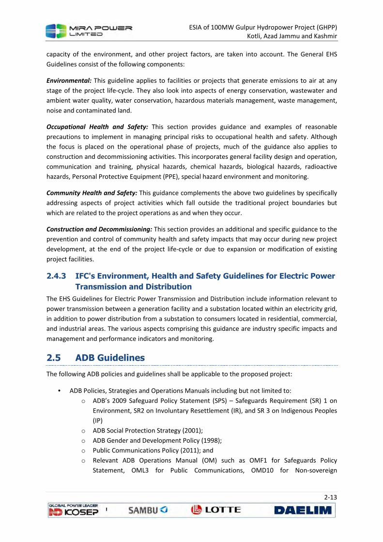
ESIA of 100MW Gulpur Hydropower Project (GHPP) Kotli, Azad Jammu and Kashmir
2-13
capacity of the environment, and other project factors, are taken into account. The General EHS
Guidelines consist of the following components:
Environmental: This guideline applies to facilities or projects that generate emissions to air at any
stage of the project life-cycle. They also look into aspects of energy conservation, wastewater and
ambient water quality, water conservation, hazardous materials management, waste management,
noise and contaminated land.
Occupational Health and Safety: This section provides guidance and examples of reasonable
precautions to implement in managing principal risks to occupational health and safety. Although
the focus is placed on the operational phase of projects, much of the guidance also applies to
construction and decommissioning activities. This incorporates general facility design and operation,
communication and training, physical hazards, chemical hazards, biological hazards, radioactive
hazards, Personal Protective Equipment (PPE), special hazard environment and monitoring.
Community Health and Safety: This guidance complements the above two guidelines by specifically
addressing aspects of project activities which fall outside the traditional project boundaries but
which are related to the project operations as and when they occur.
Construction and Decommissioning: This section provides an additional and specific guidance to the
prevention and control of community health and safety impacts that may occur during new project
development, at the end of the project life-cycle or due to expansion or modification of existing
project facilities.
2.4.3 IFC's Environment, Health and Safety Guidelines for Electric Power
Transmission and Distribution
The EHS Guidelines for Electric Power Transmission and Distribution include information relevant to
power transmission between a generation facility and a substation located within an electricity grid,
in addition to power distribution from a substation to consumers located in residential, commercial,
and industrial areas. The various aspects comprising this guidance are industry specific impacts and
management and performance indicators and monitoring.
2.5 ADB Guidelines
The following ADB policies and guidelines shall be applicable to the proposed project:
• ADB Policies, Strategies and Operations Manuals including but not limited to:
o ADB’s 2009 Safeguard Policy Statement (SPS) – Safeguards Requirement (SR) 1 on
Environment, SR2 on Involuntary Resettlement (IR), and SR 3 on Indigenous Peoples
(IP)
o ADB Social Protection Strategy (2001);
o ADB Gender and Development Policy (1998);
o Public Communications Policy (2011); and
o Relevant ADB Operations Manual (OM) such as OMF1 for Safeguards Policy
Statement, OML3 for Public Communications, OMD10 for Non-sovereign

ESIA of 100MW Gulpur Hydropower Project (GHPP) Kotli, Azad Jammu and Kashmir
2-14
Operations, OMC3 for Incorporation of Social Dimensions into ADB Operations,
OMC2 for Gender and Development; 3
The ADB’s environmental policy is grounded in its Poverty Reduction Strategy and its Long-Terms
Strategic Framework. To ensure the reduction of poverty through environmentally sustainable
development, the ADB’s Environment Policy contains five main elements: (i) promoting environment
and natural resource management interventions to reduce poverty directly, (ii) assisting developing
member countries to mainstream environmental considerations in economic growth, (iii) helping
maintain global and regional life support systems that underpin future development prospects, (iv)
building partnerships to maximize the impact of ADB lending and non-lending activities, and (v)
integrating environmental considerations across all ADB operations.
Under the last element, the ADB pledges to address the environmental aspects of its operations
through the systematic application of procedures for (i) environmental analysis for country strategy
and programming; (ii) environmental assessment of project loans, program loans, sector loans, loans
involving financial intermediaries, and private sector loans; (iii) monitoring and evaluation of
compliance with environmental requirements of loans; and (iv) implementation of procedures for
environmentally responsible procurement. In the context of policy-based lending and policy
dialogue, the ADB will identify opportunities to introduce policy reforms that provide incentives to
improve environmental quality and enhance the sustainability of natural resource management.
ADB classifies projects into category A (with potentially significant environmental impact); category
B (with potentially less significant environmental impact); or, category C (unlikely to have significant
environmental impact).4 An IEE is required for category B projects and an ESIA, requiring greater
depth of analysis, for category A projects. No environmental assessment is required for category C
projects although their environmental implications nevertheless need to be reviewed. The proposed
project has been classified as a category A project for environment.
The ADB’s requirements for environmental assessment are specified in its Environmental
Assessment Guidelines. 5 The ADB requires that an environmental assessment report and a summary
ESIA report be prepared for a Category A project. Important considerations in preparing the
environmental assessment include assessing induced, indirect, and cumulative impact, examining
alternatives, achieving environmental standards, designing least-cost mitigation measures,
developing appropriate environmental management plans and monitoring requirements,
formulating institutional arrangements, and ensuring meaningful public consultation. The format of
the environment assessment report for program loans is flexible, but includes a matrix describing
the environmental consequences and mitigation measures for the policy actions underpinning the
program loan.
The ADB requires public consultation and access to information in the environment assessment
process. For a Category A project, it is required that the groups affected by the proposed project and
3 Available from http://www.adb.org/Documents/Manuals/Operations/default.asp
4 A fourth category, FI (credit line for subprojects through a financial intermediary, or equity investment in a
financial intermediary), requires that an appropriate environmental management system should be developed and assessment carried out. 5 ADB. 2003. Environmental Assessment Guidelines. Manila: ADB.

ESIA of 100MW Gulpur Hydropower Project (GHPP) Kotli, Azad Jammu and Kashmir
2-15
local NGOs be consulted at least twice: (i) once during the early stages of ESIA field work; and (ii)
once when the draft ESIA report is available, and prior to loan appraisal by the ADB. The public
consultation process needs to be described in the ESIA and summary ESIA reports.
The EMMP is a key component of the ESIA. The ADB places strong emphasis on the preparation of
EMMPs during project processing. The EMMP sets out conditions and targets to be met during
project implementation. It is also required to develop procedures and plans to ensure that the
mitigation measures and monitoring requirements approved during the environmental compliance
review will actually be carried out in subsequent stages of the project.
The ADB, however, recognizes that the specific construction and operational activities may not be
well enough defined at the feasibility stage of the project cycle to provide the details required for an
effective EMMP. The ADB therefore requires that the Borrower ensure that a revised EMMP be
prepared at the beginning of the implementation stage. The Company will be the project proponent
and will be responsible for preparing the revised EMMP.
2.5.1 ADB's Safeguard Policy Statement 2009
Built upon the three previous safeguard policies on the Involuntary Resettlement Policy (1995), the
Policy on Indigenous Peoples (1998) and the Environment Policy (2002), the Safeguard Policy
Statement was approved in 2009. The safeguard policies are operational policies that seek to avoid,
minimize or mitigate adverse environmental and social impacts including protecting the rights of
those likely to be affected or marginalized by the developmental process. ADB's safeguard policy
framework consists of three operational policies on the environment, indigenous peoples and
involuntary resettlement. A brief detail of all three operational policies have been mentioned below:
Environmental Safeguard: This safeguard is meant to ensure the environmental soundness and
sustainability of projects and to support the integration of environmental considerations into the
project decision making process.
Involuntary Resettlement Safeguard: This safeguard has been placed in order to avoid involuntary
resettlement whenever possible; to minimize involuntary resettlement by exploring project and
design alternatives; to enhance, or at least restore, the livelihoods of all displaced persons in real
terms relative to pre- project levels; and to improve the standards of living of the displaced poor and
other vulnerable groups.
Indigenous Peoples Safeguard: This safeguard looks at designing and implementing projects in a
way that fosters full respect for Indigenous Peoples' identity, dignity, human rights, livelihood
systems and cultural uniqueness as defined by the Indigenous Peoples themselves so that they
receive culturally appropriate social and economic benefits; do not suffer adverse impacts as a result
of projects; and participate actively in projects that affect them.
Information, Consultation and Disclosure: Consultation and participation are essential in achieving
the safeguard policy objectives. This implies that there is a need for prior and informed consultation
with affected persons and communities in the context of safeguard planning and for continued
consultation during project implementation to identify and help address safeguard issues that may
arise. The consultation process begins early in the project preparation stage and is carried out on an

ESIA of 100MW Gulpur Hydropower Project (GHPP) Kotli, Azad Jammu and Kashmir
2-16
ongoing basis throughout the project cycle. It provides timely disclosure of relevant and adequate
information that is understandable and readily accessible to affected people and is undertaken in an
atmosphere free of intimidation or coercion. In addition, it is gender inclusive and responsive and
tailored to the needs of disadvantaged and vulnerable groups and enables the incorporation of all
relevant views of affected people and other stakeholders into decision making. ADB requires the
borrowers/clients to engage with communities, groups or people affected by proposed projects and
with civil society through information disclosure, consultation and informed participation in a
manner commensurate with the risks to and impacts on affected communities. For projects with
significant adverse environmental, involuntary resettlement or Indigenous Peoples impacts, ADB
project teams will participate in consultation activities to understand the concerns of affected
people and ensure that such concerns are addressed in project design and safeguard plans.
2.5.2 Social Protection Requirements
ADB's Social Protection Strategy (2001 SPS) requires the Borrower to comply with applicable labor
laws in relation to the Project, and take the following measures to comply with the core labor
standards6 for the ADB financed portion of the Project:
a. carry out its activities consistent with the intent of ensuring legally permissible equal
opportunity, fair treatment and non-discrimination in relation to recruitment and hiring,
compensation, working conditions and terms of employment for its workers (including
prohibiting any form of discrimination against women during hiring and providing equal
work for equal pay for men and women engaged by the Borrower);
b. not restrict its workers from developing a legally permissible means of expressing their
grievances and protecting their rights regarding working conditions and terms of
employment;
c. engage contractors and other providers of goods and services:
(i) who do not employ child Iabor7 or forced labor;8
(ii) who have appropriate management systems that will allow them to operate in a
manner which is consistent with the intent of (A) ensuring legally permissible equal
opportunity and fair treatment and non-discrimination for their workers, and (B) not
restricting their workers from developing a legally permissible means of expressing
their grievances and protecting their rights regarding working conditions and terms
of employment; and
(iii) whose subcontracts contain provisions which are consistent with paragraphs (i) and
(ii) above.
6 the core labor standards are the elimination of all forms of forced or compulsory labor; the abolition of child
labor; elimination of discrimination in respect of employment and occupation; and freedom of association and the effective recognition of the right to collective bargaining, as per the relevant conventions of the International Labor Organization; 7 child labour means the employment of children whose age is below the statutory minimum age of
employment in the relevant country, or employment of children in contravention of International Labour Organization Convention No. 138 'Minimum Age Convention" (www.ioo.org) 8 forced labour means all work or services not voluntarily performed, that is, extracted from individuals under
threat of force or penalty

ESIA of 100MW Gulpur Hydropower Project (GHPP) Kotli, Azad Jammu and Kashmir
2-17
2.5.3 Public Communications Policy 2011
The Public Communications Policy (PCP) of ADB, originally formulated in 2005 and revised in 2011, is
aimed at promoting improved access to information about ADB's operations related to funded
projects. It endorses greater transparency and accountability to stakeholders involved in a project.
The PCP establishes the disclosure requirements for documents and information related to projects.
It mandates project-related documents normally produced during the project cycle to be posted on
the web.
2.5.4 Gender and Development Policy 1998
ADB's Gender and Development Policy (1998) adopts gender mainstreaming as a key strategy for
promoting gender equity, and for ensuring that women participate in and that their needs are
explicitly addressed in the decision-making process for development activities. The key elements of
ADBs gender policy are: (i) Gender sensitivity, to observe how the project affects women and men
differently and to take account of their different needs and perspectives in resettlement planning;
(ii) Gender analysis, which refers to the systematic assessment of the project impact on men and
women and on the economic and social relationships between them; (iii) Gender planning, which
refers to the formulation of specific strategies to bring about equal opportunities to men and
women; and (iv) Mainstreaming, to consider gender issues in all aspects of ADB operations,
accompanied by efforts to encourage women's participation in the decision-making process in
development activities.
The SPS and safeguards requirements also reiterate the importance of including gender issues in the
preparation of safeguards documents at all stages to ensure that gender concerns are incorporated,
including gender-specific consultation and information disclosure. This includes special attention to
guarantee women's assets, property, and land-use rights and restoration/improvement of their
living standards; and to ensure that women will receive project benefits.

ESIA of 100MW Gulpur Hydropower Project (GHPP) Kotli, Azad Jammu and Kashmir
2-18
Table 2.2: Selected NEQS for Waste Effluents
Parameter Unit Standards (maximum allowable
limit)
Temperature increase °C < 3
pH value (acidity/basicity) pH 6/9
5-day biochemical oxygen demand (BOD) at 20 °C
mg/l 80
Chemical oxygen demand (COD) mg/l 150
Total suspended solids mg/l 200
Total dissolved solids mg/l 3,500
Grease and oil mg/l 10
Phenolic compounds (as phenol) mg/l 0.1
Chloride (as Cl) mg/l 1,000
Fluoride (as F) mg/l 10
Sulfate (SO4) mg/l 600
Sulfide (S) mg/l 1.0
Ammonia (NH3) mg/l 40
Cadmium mg/l 0.1
Chromium (trivalent and hexavalent) mg/l 1.0
Copper mg/l 1.0
Lead mg/l 0.5
Mercury mg/l 0.01
Selenium mg/l 0.5
Nickel mg/l 1.0
Silver mg/l 1.0
Total toxic metals mg/l 2.0
Zinc mg/l 5.0
Arsenic mg/l 1.0
Barium mg/l 1.5
Iron mg/l 8.0
Manganese mg/l 1.5
Boron mg/l 6.0
Chlorine mg/l 1.0 Notes:
1. The standard assumes that dilution of 1:10 on discharge is available. That is, for each cubic meter of treated effluent, the recipient water body should have 10 m3 of water for dilution of this effluent.
2. Toxic metals include cadmium, chromium, copper, lead, mercury, selenium, nickel and silver. The effluent should meet the individual standards for these metals as well as the standard for total toxic metal concentration. Source: Government of Pakistan (2000) (SRO 549 (I)/2000).

ESIA of 100MW Gulpur Hydropower Project (GHPP) Kotli, Azad Jammu and Kashmir
2-19
Table 2.3: NEQS for Industrial Gaseous Emissions
Parameter Source of Emission Standards (maximum
allowable limit)
Smoke Smoke opacity not to exceed 40% or 2 Ringlemann Scale or
equivalent smoke number
Particulate matter 1
(a) Boilers and furnaces:
i. Oil fired 300
ii. Coal fired 500
iii. Cement Kilns 300
(b) Grinding, crushing, clinker coolers and related processes, metallurgical processes, converters, blast furnaces and cupolas
500
Hydrogen Chloride Any 400
Chlorine Any 150
Hydrogen fluoride Any 150
Hydrogen sulphide Any 10
Sulphur Oxides 2, 3
Sulfuric acid/Sulphonic acid plants 5,000
Other Plants except power Plants operating on oil and coal
1,700
Carbon Monoxide Any 800
Lead Any 50
Mercury Any 10
Cadmium Any 20
Arsenic Any 20
Copper Any 50
Antimony Any 20
Zinc Any 200
Oxides of Nitrogen 3
Nitric acid manufacturing unit 3,000
Other plants except power plants operating on oil or coal:
i. Gas fired 400
ii. Oil fired 600
iii. Coal fired 1,200 Explanations:
1. Based on the assumption that the size of the particulate is 10 micron or more. 2. Based on 1% Sulphur content in fuel oil. Higher content of Sulphur will cause standards to be pro-rated. 3. In respect of emissions of Sulphur dioxide and nitrogen oxides, the power plants operating on oil and coal as fuel
shall in addition to NEQS specified above, comply with the standards provided separately. 4. Units are in mg/Nm
3 unless otherwise stated
Source: Government of Pakistan (2000) (SRO 549 (I)/2000).

ESIA of 100MW Gulpur Hydropower Project (GHPP) Kotli, Azad Jammu and Kashmir
2-20
Table 2.4: National Environmental Quality Standards for Ambient Air9
Pollutants Time-
Weighted Average
Concentration in Ambient Air
Method of Measurement Effective from1st
July 2010
Effective from 1
st January 2013
Sulfur Dioxide (SO2)
Annual Average*
80 µg/m3 80 µg/m
3
Ultraviolet Fluorescence
24 hours** 120 µg/m3 120 µg/m
3
Oxides of Nitrogen as (NO)
Annual Average*
40 µg/m3 40 µg/m
3 Gas Phase
Chemiluminescence 24 hours** 40 µg/m
3 40 µg/m
3
Oxides of Nitrogen as (NO2)
Annual Average*
40 µg/m3 40 µg/m
3 Gas Phase
Chemiluminescence 24 hours** 80 µg/m
3 80 µg/m
3
Ozone (O3) 1 hour 180 µg/m3 130 µg/m
3
Non-dispersive UV absorption
Suspended Particulate Matter (SPM)
Annual Average*
400 µg/m3 360 µg/m
3
High Volume Sampling, (Average flow rate not
less than1.1 m3/minute). 24 hours** 550 µg/m
3 500 µg/m
3
Respirable Particulate Matter. PM10
Annual Average*
200 µg/m3 120 µg/m
3
β Ray absorption
24 hours** 250 µg/m3 150 µg/m
3
Respirable Particulate Matter. PM2.5
Annual Average*
25 µg/m3 15 µg/m
3
β Ray absorption 24 hours** 40 µg/m
3 35 µg/m
3
1 hour 25 µg/m3 15 µg/m
3
Lead (Pb)
Annual Average*
1.5 µg/m3 1.0 µg/m
3
ASS Method after sampling using EPM 2000 or equivalent Filter paper 24 hours** 2.0 µg/m
3 1.5 µg/m
3
Carbon Monoxide (CO)
8 hours** 5 mg/m3 5 mg/m
3 Non-Dispersive Infra-Red
(NDIR) 1 hour 10 mg/m3 10 mg/m
3
* Annual arithmetic mean of minimum 104 measurements in a year taken twice a week 24 hourly at uniform interval.
** 24 hourly /8 hourly values should be met 98% of the in a year. 2% of the time, it may exceed but not on two consecutive days. Source: Government of Pakistan (2010) (SRO 1062 (I)/2010).
9Full text of the Standards is available at the Pak-EPA website:
(http://www.environment.gov.pk/info.htm).

ESIA of 100MW Gulpur Hydropower Project (GHPP) Kotli, Azad Jammu and Kashmir
2-21
Table 2.5: NEQS for Motor Vehicles Exhaust and Noise for In-use Vehicles10
Sr.
No. Parameter
Standard (Maximum
Permissible Limit) Measuring Method Applicability
1 Smoke 40% or 2 on the Ringlemann Scale during engine acceleration mode.
To be compared with Ringlemann Chart at a distance 6 or more.
Immediate effect 2
Carbon Monoxide
6% Under idling conditions: Non-dispersive infrared detection through gas analyzer.
3 Noise 85 dB (A). Sound meter at 7.5 meters from the source.
Table 2.6: NEQS for Motor Vehicles Exhaust and Noise for New Diesel Vehicles, Passenger Cars and Light Commercial Vehicles (g/Km)
Type of Vehicle
Category/Class Tiers CO HC+ NOx
PM Measuring
Method Applicability
Passenger Cars
M 1: with reference mass (RW) up to 2500 kg. Cars with RW over 2500 kg to meet NI category standards.
Pak-II IDI 1.00 0.70 0.08 NEDC (ECE
15+ EUDCL)
All imported and local
manufactured diesel vehicles
with effect from 01-07-
2012
Pak-II DI 1.00 0.90 0.10
Light Commercial Vehicles
NI-I (RW<1250 kg) Pak-II IDI 1.00 0.70 0.08
Pak-II DI 1.00 0.90 0.10
NI-II (1250 kg< RW <1700 kg0
Pak-II IDI 1.25 1.00 0.12
Pak-II DI 1.25 1.30 0.14
NI-III (RW>1700 kg) Pak-II IDI 1.50 1.20 0.17
Pak-II DI 1.50 1.60 0.20
Parameter Standard (maximum permissible limit) Measuring Method
Noise 85 dB (A) Sound meter at 7.5 meters from the
source.
10
Full text of the Standards is available at the Pak-EPA website: (http://www.environment.gov.pk/info.htm).

ESIA of 100MW Gulpur Hydropower Project (GHPP) Kotli, Azad Jammu and Kashmir
2-22
Table 2.7: NEQS for Motor Vehicles Exhaust and Noise for New Diesel Vehicles, Heavy Duty Diesel Engines and Large Goods Vehicles (g/Kwh)
Type of
Vehicle
Category/
Class Tiers CO HC NOx PM
Measuring
Method Applicability
Heavy Duty Diesel Engines
Trucks and Buses
Pak-II 4.0 1.1 7.0 0.15 ECE-R-49
All Imported and local manufactured diesel vehicles with the effect 1-7-2012
Large goods Vehicles
N2 (2000 and up
Pak-II 4.0 7.0 1.1 0.15 EDC
Parameter Standard (maximum permissible limit) Measuring Method
Noise 85 dB (A) Sound meter at 7.5 meters from the source.
Table 2.8: NEQS for Motor Vehicles Exhaust and Noise for New Petrol Vehicles (g/km)
Type of Vehicle
Category / Class Tiers CO HC+ NOx
Measuring Method
Applicability
Passenger
M 1: With reference mass (RW) up to 2500 kg. Cars with RW over 2500 kg. to meet N1 category standards
Pak-II 2.20 0.50
NEDC (ECE 15 + EUDCL)
All imported and new models* locally manufactured petrol vehicles with effect from 1
st
July, 2009**
Light Commercial
Vehicles
N1-I (RW<1250 kg) Pak-II 2.20 0.50
N1-II (1250 kg>RW <1700 kg)
Pak-II 4.00 0.65
N1-III (RW>1700 kg) Pak-II 5.00 0.80
Motor Rickshaws &
motor Cycles
2.4 strokes <150 cc Pak-II 5.50 1.50
ECER 40 2.4 strokes>150 cc Pak-II 5.50 1.30
Parameters Standard (maximum permissible limit) Measuring Method
Noise 85 dB (A) Sound meter at 7.5 meters from the
source Explanations for Table 2.4 to 2.7: DI: Direct Injection IDI: Indirect Injection EUDCL: Extra Urban Driving Cycle NEDC: New Urban Driving Cycle M: Vehicles designed and constructed for the carriage of passengers and comprising no more than eight seats in
addition to the driver's seat N: Motor vehicles with at least four wheels designed and constructed for the carriage of goods. * New model means both model and engine type change ** The existing models of petrol driven vehicles locally manufactured will immediately switch ever to Pak-II emission
standards but not later than 30th June, 2012 Source: Government of Pakistan (2009) (SRO 72 (KE)/2009).

ESIA of 100MW Gulpur Hydropower Project (GHPP) Kotli, Azad Jammu and Kashmir
2-23
Table 2.9: National Standards for Drinking Water Quality11
Properties/Parameters Standard Values for Pakistan
Bacterial
All water intended for drinking (E. Coli or Thermo tolerant Coliform bacteria)
Must not be detectable in any 100 ml samples
Treated water entering the distribution system (E. Coli or thermo-tolerant coliform and total coliform bacteria)
Must not be detectable in any 100 ml samples
Treated water in the distribution system (E. Coli or thermo tolerant coliform and total coliform bacteria)
Must not be detectable in any 100 ml samples In case of large supplies, where sufficient samples are examined, must not be present in 95% of the samples
taken throughout any 12- month period.
Physical
Color ≤15 TCU
Taste Non-objectionable/Accept able
Odor Non-objectionable/Accept able
Turbidity < 5 NTU
Total hardness as CaCO3 < 500 mg/l
TDS < 1000
pH 6.5 – 8.5
Chemical
Essential Inorganic mg/Liter
Aluminum (Al) ≤0.2
Antimony (Sb) ≤0.005 (P)
Arsenic (As) ≤ 0.05 (P)
Barium (Ba) 0.7
Boron (B) 0.3
Cadmium (Cd) 0.01
Chloride (Cl) <250
Chromium (Cr) ≤0.05
Copper (Cu) 2
Toxic Inorganic mg/Liter
Cyanide (Cn) ≤0.05
Fluoride (F)* ≤1.5
Lead (Pb) ≤0.05
Manganese (Mn) ≤ 0.5
Mercury (Hg) ≤0.001
Nickel (Ni) ≤0.02
Nitrate (NO3)* ≤50
Nitrite (NO2)* ≤3 (P)
Selenium (Se) 0.01 (P)
Residual chlorine 0.2-0.5 at consumer end; 0.5-1.5 at source
Zinc (Zn) 5.0
Organic
Pesticides mg/l PSQCA No. 4639-2004, Page No. 4 Table No. 3 Serial
No. 20- 58 may be consulted**
Phenolic compound (as phenols) mg/l WHO standards: ≤ 0.002
Polynuclear Aromatic hydrocarbon (as PAH) g/L WHO standards: ≤ 0.01v(by GC/MS method)
Radioactive
Alpha Emitters bq/L or pCi 0.1
Beta Emitters 1
11
Full text of the Standards is available at the Pak-EPA website: (http://www.environment.gov.pk/info.htm).

ESIA of 100MW Gulpur Hydropower Project (GHPP) Kotli, Azad Jammu and Kashmir
2-24
* indicates priority health related inorganic constituents which need regular monitoring. ** PSQCA: Pakistan Standards Quality Control Authority.
Source: Government of Pakistan (2010) (SRO 1063(I)/2010).
Table 2.10: National Environmental Quality Standards for Noise12
Category of Area/Zone
Limit in dB(A) Leq*
Effective from 1st
July 2010 Effective from 1st
July 2012
Day time Night time Day time Night time
Residential area 65 50 55 45
Commercial area 70 60 65 55
Industrial area 80 75 75 65
Silence zone 55 45 50 45 Notes: 1. Day time hours: 6:00 a.m. to 10:00 p.m. 2. Night time hours: 10:00 p.m. to 6:00 a.m. 3. Silence zone: Zones that are declared as such by the competent authority. An area comprising not less than 100
m around the hospitals, educational institutions, and courts. 4. Mixed categories of areas may be declared as one of the four above-listed categories by the competent
authority. * dB(A) Leq: Time weighted average of the level of sound in decibels on Scale A which is relatable to human
hearing. Source: Government of Pakistan (2010) (SRO 1064(I)/2010).
12
Full text of the Standards is available at the Pak-EPA website: (http://www.environment.gov.pk/info.htm).

ESIA of 100MW Gulpur Hydropower Project (GHPP) Kotli, Azad Jammu and Kashmir
3-1
3 PROJECT DESCRIPTION
The Gulpur Hydropower Project will exploit the water resources of the Poonch River for power
generation. It will comprise four main components, viz., Weir, Intake Structure, Power Tunnel and
Power House. The Weir will be located near Aghar Colony on the Poonch River at about 5 km
downstream of Kotli Town and about 250 m downstream of the confluence of Ban Nullah with the
river. The Intake Structure and intake portal of the Power Tunnel will be located on Ban Nullah about
2 km upstream of its confluence with the Poonch River. The Power House and outlet portal of the
Power Tunnel will be located on Poonch River about 6.5 km downstream of the Weir structure.
Figure 3.1 illustrates the layout plan of the Project.
Figure 3.1: Project General Layout Plan
The Normal Operating Level (NOL) of the Project shall be at El. 540 m. At present a freeboard of 2
meters is proposed for the land acquisition and resettlement. Figure 3.2 shows the inundation area
at El. 542.0 m.

ESIA of 100MW Gulpur Hydropower Project (GHPP) Kotli, Azad Jammu and Kashmir
3-2
Figure 3.2: Inundated Land/Houses by the Reservoir
3.1 Location of the Project
The Project site administratively belongs to Kotli District, Azad Jammu and Kashmir. It is located at
latitude 33°27’ and longitude 73°51’, which is about 5 km South of Kotli Town. The site is
approximately 167 km from Islamabad and 285 km from Lahore, and is accessible directly from
Islamabad and Lahore by a two-lane (and partially paved) mountainous road. It can be also accessed
from Islamabad via Kahuta or from Lahore using a GT road to reach Dina where connects to Mirpur
first and then Gulpur. At the Project site, river flows in a narrow gorge at a slope of about 1V:200H.

ESIA of 100MW Gulpur Hydropower Project (GHPP) Kotli, Azad Jammu and Kashmir
3-3
Figure 3.3: Project Location
3.2 Land Required for Project
The area to be consumed by the Project structures, reservoir, colony, and camp and approach roads
is given in Table 3.1 below. The table shows that the private land constitutes about 26.4 percent of
the total area to be consumed by the Project. It is only this area that is privately owned, while the
rest of the area is government land. About 88 percent (803 Acres) of the land required for the
proposed project will be utilized for the reservoir. In total the proposed project will required 919.85
Acres of land, major portion (74 percent) of this requirement will be fulfilled through usage of
government wasteland.
Table 3.1: Area Requirement for the Proposed Project
S.
No. Structure/ Item
Total
Area
(Acres)
Private Land Government Land
Ownership Shamilat Auqaf KDA Forest Wasteland
1 Power Complex 2 - - - - - 2
2 Weir 10 - - - - - 10
3 Intake 1 - - - - - 1
4 Reservoir 803.85 127.64 84.80 39 57.25 8.81 486.36
5 Spoil Dumping Areas 36 3 1 - - 14 18
6 Colonies/Camps/Stores/Workshops
54 24 2 - - 2 26
7 Access Roads for Power House
13 - - - - - 13
Total 919.85 154.64 87.80 39 57.25 24.81 556.36
Percentages 100% 16.8% 9.5% 4.2% 6.2% 2.7% 60.5%

ESIA of 100MW Gulpur Hydropower Project (GHPP) Kotli, Azad Jammu and Kashmir
3-4
3.3 Main Components of the Project
3.3.1 The Weir
The weir type has been determined as concrete gravity dam (CGD) with dimensions of W45.0 m ×
L237.0 m to prevent overflow even in case of probable maximum flood (PMF). 100-year frequency
flood (13,334 m3/s) has been applied to the spillway overflow section, and spillway type has been
determined as radial gate type in consideration of economic aspects, constructability, functionality
and Q&M. The discharge capacity of the spillway has been designed to maintain the normal
operation level (EL.540.0 m) in case of the 100-year frequency flood. Eight gates (W 11.5 m ×H 26.0
m EA) are installed inside the weir body to prevent overflowing the weir crest (El.545.0 m) even in
case of probable maximum flood (PMF). A 9.5 m wide roadway bridge with its crest at El. 545.0 m
will provide access from one bank to other bank of the river. Bridge shall also be used to operate
gate hosting equipment.
Ogee shaped crests for weir portion is connected to submerged roller bucket type energy dissipater
through concrete chutes. The project site displays an extremely high downstream level due to
relatively large amount of flow compared to the river width. It was observed that the downstream
level becomes higher than the water level after hydraulic jump in case of floods higher than 2- year
frequency flood (4,190 m3/s). Submerged roller bucket type has been chosen as a result due to
excessive excavation and absence of major structures at downstream.
Figure 3.4: Details of Weir Structure

ESIA of 100MW Gulpur Hydropower Project (GHPP) Kotli, Azad Jammu and Kashmir
3-5
3.3.2 Power Tunnel and Penstocks
The power tunnel off-takes from the left bank of Bann Nullah at a location about 2 km upstream of
its confluence with Poonch River. The tunnel will be concrete lined and circular in shape having a
total length of 3.04 Km. The invert of tunnel intake is kept at El. 523 m to avoid vortices and air
entrance. The intake structure will have a bell-mouthed entrance with trash-rack and a gate shaft. A
road along the left bank of Bann Nullah will be constructed for operation & maintenance of this
structure. The intake arrangements are shown on Figure 3.5 and Figure 3.6.
First part of the power tunnel is designed as a low pressure tunnel of 8.0 m dia, concrete lined,
almost bored straight in the hill up to a 62.64 m high surge shaft. Downstream of surge shaft, tunnel
will connect to a vertical pressure tunnel which will connect to an 8.0 m dia steel penstock which will
be divided into three steel penstocks each 3.75 m dia up to the powerhouse.
Hydraulic features of the power tunnel/penstocks are as given below:
Design discharge 198 cumecs
Shape and size of tunnel Circular, concrete lined, 8 m
Slope of tunnel invert 0.0025
Length of tunnel 3.04 km
Invert elevation
Upstream El. 523.0 m
Downstream El. 514.0 m
Size of penstock 8 m Ø, circular, steel pipe converted into 3.75 m pipe
Length of penstock 62 m
Head Loss
Tunnel 5.69 m
Penstocks 0.85 m
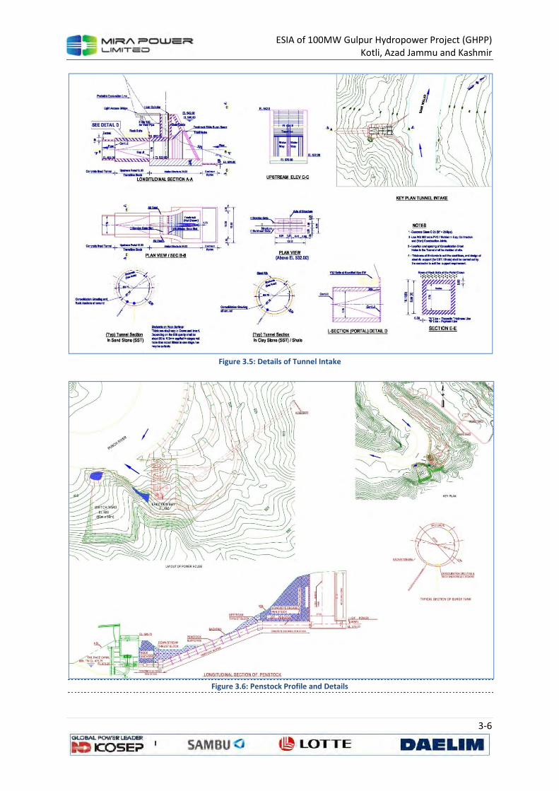
ESIA of 100MW Gulpur Hydropower Project (GHPP) Kotli, Azad Jammu and Kashmir
3-6
Figure 3.5: Details of Tunnel Intake
Figure 3.6: Penstock Profile and Details

ESIA of 100MW Gulpur Hydropower Project (GHPP) Kotli, Azad Jammu and Kashmir
3-7
3.3.3 Powerhouse
The priority for the horizontal alignment of the tunnel was to set the length as shortest as possible,
but a curvature was inevitable due to the relocation of the tunnel (84 m downstream from the
Feasibility Study location). The radius of the curvature has been determined as 300 m in order to
provide sufficient space additionally to the minimum turning radius required for the excavation
equipment and steel form (200 m). The tunnel alignment has been designed to cross where the
ground condition is sounder, and for the tunnel axis to intersect with major fault zones as
perpendicularly as possible. Sufficient cover thickness was also taken into account in case the tunnel
route crosses below gullies or valleys. Total installed capacity of the powerhouse is 100 MW and
power will be generated with the help of 3 vertical axis Francis turbines. The powerhouse is 80 m
long and 42.3 m wide. Water from draft tubes will be released back into the river with the help of a
tailrace channel. A retaining wall has been proposed to protect the powerhouse from high tailwater
level during floods.
The proposed powerhouse is a surface type and will be located on left bank of the river at a massive
bed of sandstone. Layout of the powerhouse is shown in Figure 3.7, Figure 3.8 and Figure 3.9. The
basic parameters are given below:
Power Station and Equipment
Structure
Powerhouse Surface type
Number of Units 3
Distance between centerline of units 15.0 m
Overall length 42.3 m
Width
Overall height 59.55 m
Turbines
Type Francis (Vertical Shaft)
Discharge at rated head 33~66 m3/s
Rated net head 55.8 MW
Output at rated net head 34.0 MW
Specific speed 227.3 rpm
Synchronize speed 187.5 rpm
Runaway speed
Runner diameter 3.0 m

ESIA of 100MW Gulpur Hydropower Project (GHPP) Kotli, Azad Jammu and Kashmir
3-8
Figure 3.7: Power House Security Plan
Figure 3.8: Power House Plan

ESIA of 100MW Gulpur Hydropower Project (GHPP) Kotli, Azad Jammu and Kashmir
3-9
Figure 3.9: Power House Longitudinal Section
3.3.4 River Diversion
A 2-stage river diversion plan has been proposed for the construction of the Weir. The diversion will
be manipulated within the river section by constructing coffer dams. This will save the additional
cost of diversion tunnels. Two coffer dams will also be provided for the construction of other
components, one for Intake Structure for the Power Tunnel and the other for Power House.
Diversion of river flows during construction is required at three locations:
1. At the weir
2. At intake structure of power tunnel in Bann Nullah and
3. At powerhouse
To facilitate the construction of weir, diversion installation consists of 1st cofferdam and 2nd
cofferdam. The crests of the first and second cofferdams have been computed by using HEC-RAS
based on the 1-year frequency flood. Firstly, 1st cofferdam is constructed on the left bank. As a
result of water levels estimated for the design flood, the crest of the 1st cofferdam has been
determined as EL.525.0 m due to the water level of EL.524.02 at the 1st cofferdam upstream, and
the water level of EL.524.0 m has been determined separately for the downstream where the water
level is EL.523.44m. Due to the narrow river width, the 2nd cofferdam is installed by connecting a
retaining wall to the structure installed during construction of the 1st cofferdam, and water flow is
induced into the weir structure installed. The water level was computed as EL.525.3 m and the crest
has been determined as EL.526.0 m. The intake structure of the power tunnels will be separated
from Ban Nullah by constructing a cofferdam around the intake area. Similarly the powerhouse will
be isolated from the main river through another cofferdam.

ESIA of 100MW Gulpur Hydropower Project (GHPP) Kotli, Azad Jammu and Kashmir
3-10
Figure 3.10: Diversion Scheme for Weir Sluesway
3.3.4.1 River Flows and Cofferdams Heights
Weir
The construction work on weir structure will be carried out during low flow period of nine months
extending from October to June and during the main flood months of July, August and September
construction activity will cease and construction machinery and equipment will be retrieved to
higher ground.
Power Tunnel Intake Structure
Work on intake structure of the power tunnel is an independent activity and can be accomplished
during the low flow period of October through June. Cofferdam has been designed to isolate the
intake structure area from nullah flows. Crest of the cofferdams is worked out as El. 527.0 m.
Powerhouse
Construction work on powerhouse will be continued throughout the year. The crest of cofferdam
has been worked out as El. 485.0 m.
3.3.5 Dyke
In order to minimize resettlement due to inundation of the cultivated land and the number of
houses, MWH/NESPAK conducted a study and concluded a technically viable option. MWH/NESPAK
applied these studies to minimize the resettlement on the right as well as left bank of the upstream
submerged area and emphasized to save Hill Kalan, Hill Khurd, KDA and Mandi Juzvi on the right
bank (Zone-A), Laloi area (Zone B) & Mandi area (Zone C) on the left bank of the river.

ESIA of 100MW Gulpur Hydropower Project (GHPP) Kotli, Azad Jammu and Kashmir
3-11
Figure 3.11: Zones for Dyke Structure
NESPAK has recommended earthen filled dyke and varied the length of the dyke on the right bank of
river to get optimum solution by comparing it with that of tentative resettlement cost and
recommended best suitable length for building of earthen filled dyke on right bank of the river. In
order to take care of catchment water of mountains and other area, NESPAK has divided the whole
catchment area into two portions by proposing a Collection Drain at about El. 540 m. to get the
catchment water of the mountains and areas above 540 level to this Collection Drain and throw the
same into the river without any de-watering arrangement. For remaining catchment areas of about
70 Acres (from dyke to 540 level), another drain is proposed adjacent to the dyke which will be
catered through some de-watering arrangements or through flip-flop valves in the dyke. (Figure 3.12
showing different options for dykes)

ESIA of 100MW Gulpur Hydropower Project (GHPP) Kotli, Azad Jammu and Kashmir
3-12
Figure 3.12: Different Options for Dykes
3.4 Construction Schedule
It is anticipated that the Project would take about 45 months for its completion and commissioning.
The construction period for each project has been presented in Table 3.2.
Table 3.2: Summary of Construction Periods
Feature Time (Months)
Weir 30
Intake 8
Power Tunnel 32
Powerhouse construction and installation 24
Switchyard installation 7
Surge Shaft 4
Penstock liners 12
Control Gates 12
Commissioning (Dry & Wet) 10
3.5 Construction Camp and Workforce
A large workforce, together with supervisory and support staff, will be required for the Project. It has
been estimated that the Project will employ about 700 skilled, semi-skilled and unskilled workforce
for its construction. Majority of unskilled and to some extent semi-skilled and skilled workforce will
be employed from the local area. However, the contractor will engage specialized workforce
including engineers, geologists and construction management staff from the outside area. While
most of the local workforce will go back to their dwellings on daily basis, the remaining will be
accommodated in three camps located near construction sites at Weir, Intake and Power House.

ESIA of 100MW Gulpur Hydropower Project (GHPP) Kotli, Azad Jammu and Kashmir
3-13
Adequate temporary camps, offices and ancillary facilities at convenient locations near the site will
be required. Owing to the hilly terrains, there is a limitation in the availability of ample areas at the
sites near the Weir and Power House for establishing residences, workshops, batching plants and
material storage areas separately. However, a sizeable nearly leveled terrace is available across the
Ban Nullah at the Intake site where the contractor can establish residential colony as well as other
facilities. Moreover, modern houses are also available in Kotli Town on rental basis. The contractor
may hire these for establishing main office and hostels for the workforce.
3.6 Access Routes for Construction Sites
The Project falls in a terrain that is constituted of high hills having steep slopes with narrow valleys in
between. Though the Weir and Power House sites lie close to the main road leading from Kotli to
Mirpur, the sites are located down the hills having very steep slopes. On the other hand the Intake
site is located about 2 km away from the main road devoid of any motor-able access. The contractor
would need to develop access roads for all the sites.
The site is located about 170 Km from Islamabad and 285 km from Lahore, it is directly approachable
from Islamabad and Lahore by a two-lane, all-weather paved mountainous road. Access to the
Project site from Islamabad is via Kahuta to Kotli and to Gulpur. The other route is from Lahore via
GT Road to Dina and then to Mirpur and to Gulpur. During rainy season, traffic is susceptible to
occasional disruptions due to landslides.
To carry out construction of Project components, there will be a need for temporary access roads
connecting stockpile areas, work areas such as cofferdams, tunnel portal, batching plant(s) and site
workshops for hauling labour and materials within the jobsite. Access roads required for
construction of various Project components are planned and shown in Figure 3.13.

ESIA of 100MW Gulpur Hydropower Project (GHPP) Kotli, Azad Jammu and Kashmir
3-14
Figure 3.13: Project Area Access Roads
These roads are planned along the shortest and practicable route at reasonable grades, maximum
allowed grade is 6%, nevertheless, ramps may be steeper. Details are given in Table 3.3.
Table 3.3: Project Construction Roads, Lengths & Gradients
Roads Length (km) Elevation (m) Gradient
From To From To From To
ROADS TO INTAKE PORTAL AREA
Main Kotli Road Construction Camp 0+000 0+500 570 575 1.00
Main Kotli Road Construction Camp 0+500 1+000 575 595 4.00
Main Kotli Road Intake Portal 0+500 1+450 575 520 5.80
Rehman Bridge Intake Portal 0+000 1+350 550 520 2.25
Alternate Camps Intake Portal 0+000 1+050 565 520 4.30
ROADS TO WEIR
Main Kotli Road Construction Camp
Weir Upstream 0+000 0+620 525 500 4.05
Main Kotli Road Construction Camp
Weir Downstream 0+000 1+300 560 500 4.65
ROADS TO POWERHOUSE
Main Kotli Road Powerhouse 0+000 2+200 600 475 5.70
Main Kotli Road Concrete Mixing Plant & Powerhouse
0+000 2+300 600 475 5.45
Concrete Mixing Plant Main Kotli Road for going to weir & Intake Portal
0+000 1+1000 575 630 5.50

ESIA of 100MW Gulpur Hydropower Project (GHPP) Kotli, Azad Jammu and Kashmir
3-15
3.7 Construction Material
The materials used for the construction of the proposed project include coarse aggregates, fine
aggregates (sand), rock for stone pitching and riprap, earth, water, cement and steel. Tentative
quantities of various materials along with the source are depicted in Table 3.4:
Table 3.4: Quantities AND Sources OF Construction Material
Sr.
No. Item Quantity Source
1 Coarse Aggregate 300,000 cu m
The material will be borrowed from the following sources:
• River Bed boulders, gravels, cobles. Crushers are already in operation near Kotli and Gulpur Towns.
• Sandstone from excavation of weir, tunnel and power house areas
• Quarrying limestone from Sawar (22 km from Kotli on Kotli-Tatapani Road), Dandli (16 km from Kotli on Dandli-Ghoi Road), Jhanjora (34 km from Kotli on Tatapani-Ghoi Road) Small scale quarrying is already being done on these sites by a local contractor for road and building construction.
2 Fine Aggregate (Sand) 150,000 cu m
Sand is though available in the river bed, its quality is not suitable for the Project construction. Moreover its quantities are small. Therefore, it has to be either transported from Lawrencepur and Qibla Bandi located in Attock District about 200 km from Kotli or manufactured locally from limestone sources.
3 Rock Material for Stone pitching and Riprap
5,000 cu m
Rock material will generally be available from the excavation for the construction of weir, power house and tunnel.
4 Cement (including Portland (60,000 tonnes and Slag 30,000 tonnes)
90,000 tonnes
There is no cement factory in AJK. The Portland cement will be transported from Islamabad, Nowshera and Attock on the average located at a distance of 200 to 300 km from Kotli. Slag Cement will be transported from Karachi (about 1500 km from Kotli) through rail and road transportation. The road network is available from the factories up to construction sites. However, its transportation on large truck-trailers will be difficult as about 100 km of the road passes through hilly terrains, encountering very sharp turns and having rather steep gradients at places. Therefore, a caravan of about 30 trucks would be required to meet daily requirement of cement of about 300 tonnes.
5 Reinforcement Steel 15,000 tons
The steel of the desired specification will be transported from re-rolling mills located at Lahore and Rawalpindi.
6
Water (including concreting, water sprinkling, compaction of earth/rock fill for cofferdams)
100,000 cu m
The project area is almost devoid of groundwater source. Therefore, the Poonch River and Ban Nullah are the only sources for water. The water from the river and nullah would however need some sort of treatment to make it silt and sulphate free for its use in concreting.
3.8 Construction Machinery
The Project will deploy various types of machineries for construction purposes. These will include
bulldozers, excavators, shovels, tunneling machine, dumpers, batching plant, tankers, trucks, etc.

ESIA of 100MW Gulpur Hydropower Project (GHPP) Kotli, Azad Jammu and Kashmir
3-16
3.9 Excavated Material
The Project will generate about 1.0 M cum of rock material (mostly constituted of sandstone and
siltstone) from excavation for the Project components. Excavation for Weir will generate a quantity
of about 0.56 M cu m, Power Tunnel 0.211 M cu m and Power House 0.20 M cu m. Depending upon
the quality of the excavated stone material, some quantity will be used to meet the requirement of
aggregate, rock fill at cofferdams, stone pitching, etc. However, bulk of the excavated material will
need to be disposed off. The configuration of the land mass in vicinity of the project structures and
in the surroundings is such that limited appropriate area would be available for disposal of the waste
material. The area is mostly constituted of high hills that are generally occupied by forests, limited
area of nearly flat benches that are occupied partly by settlements and partly used for cultivation,
and narrow river and nullah gorges. None of these really contain suitable areas for dumping the
waste material. Through a reconnaissance of the areas it has been inferred that the well stabilized
gullies in the forest areas and open wasteland benches along the river may be used for the purpose.
In this respect, the matter was discussed with the officials of the Forest Department. They have
given consent that under special case the Department would allow using these gullies provided a
written request is forwarded in advance so that the plantation from the dumping area may be
removed. It will also be required that these areas are re-vegetated with the trees after appropriately
dumping and leveling of the material. Some gullies are also available in civil area near the power
house that can be used for the purpose. Many of the drainage channels from the hills are having
very steep slopes. These may also be used for dumping purposes off course with a plan that their
slopes become milder without impeding their drainage characteristic. Details of excavated rock
material are given in Table 3.5.
Table 3.5: Rock Excavation Quantities and Periods
Feature Estimated Quantity
(m3)
Time
(months)
Peak Quantity
m3/day
Weir 475,000 14 1600
Tunnel 268,000 21 600
Intake 13,715 2 600
Powerhouse 95,000 4 1200
Surge Shaft 3,000 1.5 100
Penstock 40,000 2.5 750
Switchyard 90,000 4 1100
3.10 Project Cost
The Project cost will be approximately US$ 340.00 million.

ESIA of 100MW Gulpur Hydropower Project (GHPP) Kotli, Azad Jammu and Kashmir
4-1
4 DESCRIPTION OF THE PHYSICAL
ENVIRONMENT
4.1 General
This chapter summarizes the available baseline data on physical environment within the principal
area of interest i.e. the area of project influence. Reconnaissance visits and physical field surveys
were carried out in August 2013. Validation of this information was done through the data from
secondary sources, satellite imagery study and published literature. The identification of physical
characteristics of the region and assessing their existing conditions is imperative to predict the
possible environmental impacts of the proposed hydropower project.
The baseline environmental data has been compiled to cover the following areas:
• Land;
• Climate and Meteorology;
• Water (water resources, water quality, source of pollution and hydrology);
• Air Quality and Noise (noise levels);
4.2 Area of Study
Gulpur Hydropower Project site is located on Poonch River, which is a left bank tributary of Jhelum
River. Four hydropower projects are planned along the Poonch River; Sehra, Kotali, Gulpur and
Rajdhani13 . In the vicinity of the project site, Poonch River flows through a deep gorge at a slope of
about 1V:200H. Mountains on both sides are more than 100 meter high; valley is narrow and banks
are steep. Width of the river varies from 60 to 90 m. Kotli-Gulpur road runs along the left bank at
about 60 to 80 m above the riverbed. Ranger Nullah on the right bank and Bann Nullah on the left
bank are two main perennial tributaries, which join the river downstream of Kotli Town. Several
villages are located on both banks of the river and along both nullahs. Majority of the settlements is
above El 540 m.
The site of Gulpur Hydropower Project is located downstream of Kotli and upstream of the proposed
Rajdhani Hydropower Project. Minimum tail water level of Kotli Hydropower Project is fixed at El 550
m. Whereas, maximum reservoir level of Rajdhani Hydropower Project is fixed at El 473.5 m.
Location and reservoir levels of these projects are shown in Figure 4.1.
13
P&D-AJK’s Year Book 2011.

ESIA of 100MW Gulpur Hydropower Project (GHPP) Kotli, Azad Jammu and Kashmir
4-2
Figure 4.1: Project Location and Components
4.2.1 Delineation of the Study Area
From environmental view the study area is defined as the areas of project influence. Some of these
areas are directly affected while others may be influenced indirectly. For this Project the areas of
most concerns are as follows:
• Areas falling in the vicinity of the structures, viz., Weir, Power House, and upstream and
downstream portals of the Power Tunnel,
• Areas to be used for establishing construction camps and colony,
• Areas likely to be submerged by water impoundment,

ESIA of 100MW Gulpur Hydropower Project (GHPP) Kotli, Azad Jammu and Kashmir
4-3
• Areas likely to be used for dumping of spoil material from excavation of tunnel, weir and
power house,
• Areas to be used for developing haul tracks,
• Quarry areas,
• About 6.5 km stretch of the river reach from Weir up to the Power House that is going to be
deprived from the river flows during low-flow season for its diversion into the Power Tunnel
for power generation,
• Areas located on high-benches through which the Power Tunnel is going to be excavated.
These areas are not going to be directly affected, but it is likely that the settlements on these
benches may be disrupted due to vibrations from blasting and drilling at the Power Tunnel.
• Kotli Town is not going to be directly affected by the project; however, the area is likely to
have indirect effects of mixed type. Primarily, the induction of heavy machinery and
vehicles, particularly when transporting construction material from quarries falling on other
side of the town, will cause traffic congestions and hazards, while on the other hand the
induction of outside workforce will be beneficial in boosting the local business.
• The population residing on the right side of the Poonch River is dependent on Kotli for
business, service, shopping, etc is going to be affected due to break in the communication by
the creation of the reservoir.
Most of the potentially affected areas, except the ones related with the quarries, would fall within a
strip of about 4 km wide (on the average 2 km on either side of the Poonch River) and about 10 km
in length covering the river stretch from Kotli up to the Power House site. As such, the study area
comes to about 50 sq. km. The quarry sites have presently been excluded from the study area as the
sites indicated for quarrying are tentative and would be finalized when the contractor is mobilized
(Figure 4.2).

ESIA of 100MW Gulpur Hydropower Project (GHPP) Kotli, Azad Jammu and Kashmir
4-4
Figure 4.2: Area of Influence for the Propose Project
4.3 Land Environment
The different geological and physiographic features of the project area were analyzed using GIS tools
and interpretation of the spatial databases were completed through secondary data like Survey of
Pakistan toposheets, satellite imagery and other available data sources.
4.3.1 Geology
The study area is a part of land formations developed at the foothills of Himalayan Ranges through
tectonic events subsequent to those that caused building of Himalaya. The Project area contains
middle Siwalik formations developed from the sedimentary deposits contributed by a number of
drainage channels from the uprising Himalayan Mountain Ranges. The rock formations include
extremely folded beds, having almost vertical dips, of various types of sandstones, clay-stones and
siltstones. As compared to Himalayan Ranges, the mountains of the project area have low to
medium surface relief. The Poonch River and nullahs generally pass through deep and narrow gorges
having almost vertical slopes. Occasionally, relatively wide valleys are also encountered here and
there which are being used for settlements and agricultural activities. The typical examples in the
project area are Kotli and Gulpur towns. Similarly, some open and relative flat areas are also

ESIA of 100MW Gulpur Hydropower Project (GHPP) Kotli, Azad Jammu and Kashmir
4-5
encountered on the raised benches/terraces on the mountains. Invariably these areas are also used
for settlement and agricultural activities. The typical examples of the raised benches are the Barali
Village in the vicinity of the Power House and Dheri and Banor Ki Dhok near the Intake of the Power
Tunnel.
Mostly the mountains are covered with primary soils, except along the river and nullahs where the
beds are almost devoid of soil material either for steep slopes or for the scouring action of the
river/nullahs flows. Within the flood plains where slopes are milder to nearly level deposits of
secondary soils are met with. Such areas include Mandi, Mandi Juzvi, Hill Kalan, and Laloi areas of
Kotli Town and a small bench near Jamalpur Village, part of which are used for agricultural purposes.
Figure 4.3: Regional Geological Map of the Area.

ESIA of 100MW Gulpur Hydropower Project (GHPP) Kotli, Azad Jammu and Kashmir
4-6
Major geological formations in the project area are;
4.3.1.1 Pliestocene and Recent Deposits Overburden
The overburden present in the area is river alluvial material and overburden on the terraces. River
alluvial material is present in the river bed, and along the slopes of the river valley. The thickness of
alluvial material in the river bed is between 3.0 m to 5.0 m. This material consists of sandy gravels,
cobbles and some boulders, which are rounded to sub-rounded, few sub-angular, semi spherical,
some platy and oblonged, generally of igneous and metamorphic origin, some sedimentary
(sandstone and limestone) origin are also present. The overburden on the terraces and especially
along the alignment of power tunnel and around the proposed portal consists of weathered clay and
siltstone with pieces of sandstone. The terraces in and around to Barali village area consist of sand,
gravel and silt.
4.3.1.2 Secree, Talus and Vegetation
Overburden on the slopes of the river valley is of detritus and detached blocks and boulders of
sandstone, at places mixed with weathered and eroded siltstone and claystones. The material is
mostly composed of different sizes of broken pieces of rocks due to weathering effect on parent
rock. The vegetation consists of self-grown plants and grass, thorny bushes and small trees planted
by WAPDA Watershed Management and Forest Department.
4.3.1.3 Classification of Rocks
Petrographically, this part of Nagri Stage of Siwaliks also has three main units of rocks which are:
a. Sandstones of various strength and cementation
b. Claystones
c. Siltstones
4.3.1.4 Sandstone
Sandstones of this part of Nagri (middle Siwaliks) have also been classified into three categories:
1. Sandstone-1 (Sst-1). This type of sandstone is always present in the form of ribs and
lenses in the main beds of sandstone-2.
2. Sandstone-2 (Sst-2). Moderately strong to strong, dirty greenish grey to light brownish
grey, medium to coarse grained, moderately to well cemented and cross bedded.
3. Sandstone-3 (Sst-3). Moderately weak to moderate strong, light brownish grey to grey,
fine grained, at places silty, slightly to moderately weathered, highly weathered at
places, thinly bedded, closely jointed and fractured generally present in thick beds of
clay and siltstone.
4.3.1.5 Claystone/Siltstone
Alternate beds of Cst/Mst of various shades vary in thickness from place to place. Siltstone is
moderately weak to moderate strong, various shades of brown and brownish grey, moderate thick
to thinly bedded partly laminated, moderately weathered at exposed surfaces, moderately to closely
jointed and moderate fractured.

ESIA of 100MW Gulpur Hydropower Project (GHPP) Kotli, Azad Jammu and Kashmir
4-7
Figure 4.4: Geological Map of the Project Area
4.3.2 Seismicity
Earthquakes pose a multitude of hazard to dams, either by direct loading of the structures or by
initiating a sequence of events that may lead to dam failure. The project area lies very close to the
Riasi Thrust which is a branch of the Main Boundary Thrust (MBT). Virtually, the former almost

ESIA of 100MW Gulpur Hydropower Project (GHPP) Kotli, Azad Jammu and Kashmir
4-8
passes through or near to the course of the Poonch River, while the latter bounds the Project area at
a distance of about 5 km towards east. Consequently, the proposed Project will be located in active
seismic region that has experienced numerous large earthquakes with magnitude greater than 7
(Figure 4.5). These are believed to be associated with MBT in Himalayan range. A detailed study of
seismic hazard is provided in Annexure 1.
Figure 4.5: Seismotectonic Map of the Area
The micro-seismic data of the region indicate that the region is very active on a micro-seismic level
with frequent earthquakes of magnitude greater than 4. The largest earthquake recorded by
regional network is the Kangra earthquake of magnitude Ms=8.0 occurred on 4th April 1905 about
200 km southeast of the project. Two earthquakes of magnitude greater than 6 have also been
recorded in this area.
Figure 4.6 shows distribution of seismicity with depth in the region as recorded by Mangla
microseismic network. Major concentration of earthquakes is within upper 20 km. It is important to
note that all the events having magnitude 5 or greater are originated within shallow depth (< 20 km).
This aspect of seismicity depicts that seismic forces are active at shallow depth, which increases
earthquake hazard within this region. Majority of the events falls within focal depths less than 30
km. Though, events with magnitude greater than 5 do not seem to occur beyond 30 km depth,
nevertheless, events with magnitude 4 to 5 do occur at depths up to as much as 60 km. There is only
one earthquake that was located at focal depth of 79.3 km.

ESIA of 100MW Gulpur Hydropower Project (GHPP) Kotli, Azad Jammu and Kashmir
4-9
Figure 4.6: Micro-seismicity of the Project Area
4.3.3 Drainage
Situated in the Jammu and Kashmir region, catchment of the Poonch River down to the proposed
weir is about 3800 km2, with many snow fed and rain fed rivulets/streams with dendritic drainage
pattern. It originates in the western foothills of Pir Panjal range, in the areas of Neel-Kanth Gali and
Jamian Gali. It is called 'Siran' in this area. It flows to the north west. At first flowing southwards it
enters Mangla Lake near Chomukh. The towns of Poonch, Sehra, Tatta Pani and Kotli are situated on
the banks of this river. It has two major tributaries in Pakistan, Batar and Mendher. The Poonch River
originates at an elevation of more than 3500 m and traverses about 110 km from east to west up to
the proposed weir site and fed by many big and small streams on both the banks. Most of the
tributaries join the river on its right bank (Figure 4.7).
-90
-80
-70
-60
-50
-40
-30
-20
-10
0
3.5 4 4.5 5 5.5 6D
ep
th (
kms)
Magnitude

ESIA of 100MW Gulpur Hydropower Project (GHPP) Kotli, Azad Jammu and Kashmir
4-10
Figure 4.7: Poonch River Catchment Area with Highlighted Catchments of Tributaries
Bann Nullah: A left bank tributary has a relatively steep gradient. It joins the Poonch River at the
proposed weir site. Catchment area of the nullah is about 423 km2 and mean annual runoff is about
450 Million Cubic Meters (MCM).
Rangur Nullah: About 3 km upstream form the proposed weir site, this ephemeral tributary joins
Poonch River at right bank near Kotli. With a catchment area of about 400 km2 it is also joined by
smaller tributaries like Sarsawah Nullah.
Mendher River: It is a snow fed perennial right bank tributary of Poonch. It joins Poonch River near
Sehra about 33 km upstream from proposed wear site.
Rangar Nullah: It runs about 18 km from its point of origin, before joining Poonch River on right
bank, about 42 km upstream of the proposed project site, near Sehr Kakota. This is the last major
tributary of Poonch in Azad Kashmir. The settlement of Hajira is also located on this tributary.
Rangun Nullah: It is about 19 km ephemeral tributary. It originates in AJK, near the villages of Bandi
and Jhaniwala and joins Poonch River, on right bank.

ESIA of 100MW Gulpur Hydropower Project (GHPP) Kotli, Azad Jammu and Kashmir
4-11
Batar Nullah: This is a perennial right bank tributary of Poonch River fed by many small nullahs. It
joins the Poonch River about 56 km upstream from the proposed project site.
Mandi River/Suran River: About 10 km upstream from Poonch city, the river split into two perennial
tributaries the northern tributary is Mandi River and the southern tributary is Suran River. The major
tributary Suran River is the source of Poonch River, having its source, 39.5 km upstream from the
junction point, in the Pir Panjal range. The total catchment area of these rivers is about 1260 km2.
4.3.4 Elevation Bands (Relief)
The relief in the catchment area of Poonch River varies from 200 m to 4500 m. This elevation range
was divided into 9 elevation bands with 500 m interval (Figure 4.9). The area of catchment area (in
terms of sq. kms and percentage) which comes under these 9 elevation bands is given in Table 4.1
and depicted in Figure 4.8. It is clear from the graph that most of the catchment area of proposed
project (approximately 67%) has an elevation in the range of 500-2500m. The proposed location of
project site has an elevation of 500 m ±50 m.
Table 4.1: Area and Percentage of Different Elevation Bands of Catchment Area
Elevation Band Catchment Area
Area (Sq. Kms) Percentage (%)
0-500 22.72 0.59
501-1000 719.57 18.69
1001-1500 832.76 21.63
1501-2000 590.98 15.35
2001-2500 433.51 11.26
2501-3000 372.68 9.68
3001-3500 321.48 8.35
3501-4000 291.06 7.56
4001-4500 265.27 6.89
Figure 4.8: Area Profile under Different Elevation Bands
0.00 100.00 200.00 300.00 400.00 500.00 600.00 700.00 800.00 900.00
0-500501-1000
1001-15001501-20002001-25002501-30003001-35003501-40004001-4500
Area (Sq.Kms)

ESIA of 100MW Gulpur Hydropower Project (GHPP) Kotli, Azad Jammu and Kashmir
4-12
Figure 4.9: Elevation Band Map of Catchment Area of Poonch River
4.3.5 Land Use and Land Cover
The lands on the hills generally belong to the Forestry Department and bear forests of pine trees.
The lands on the high benches within hilly areas, however proprietary, are used for cultivation and
settlements. The river and nullah beds along with the adjacent slopes are again the government
property. As such, the proposed project components, viz., Weir, Intake structure including intake
portal of the Power Tunnel and Power House including penstocks, will be located on the government
land. Though some proprietary land exists in the area of Intake structure, it lies on a quite high
bench and will not be affected by the construction activities. Similarly, the Power Tunnel will pass
underneath the lands belonging either to the Forestry Department or to individual owners of the
Barali Village. Either of these lands would not be affected by the Project as the tunnel will be many
tens of meters below the natural surface. Similarly, the land required for construction camps and
colony has been proposed to be acquired from the land available on the raised benches near the
structures.

ESIA of 100MW Gulpur Hydropower Project (GHPP) Kotli, Azad Jammu and Kashmir
4-13
On the other hand, the reservoir will consume both government and proprietary lands. Of this,
however, the major chunk is the government land. Majority of the terrace land falling in the
floodplain of the Poonch River in the Kotli Valley belongs to Auqaf Department attached with a
shrine that was inundated and demolished by 1992 flood. Thus the proprietary land likely to be
submerged by the reservoir will be a small fraction of the total reservoir area.
4.3.6 Soil
The texture of the primary soils varies
from moderately fine to moderately
coarse depending upon the rock type
from which these have developed.
However, the secondary soils are mostly
moderately coarse textured. The soils of
the raised terraces in floodplains are
generally devoid of the stony material.
The soils of lower terraces generally
contain varied quantities of pebbles,
cobbles and boulders.
During site visit conducted in August
2013, soil samples were collected from
the following 5 locations:
1. Barali village;
2. Gulhar;
3. Mandi Juzvi;
4. Jamal Pur;
5. Weir Site;
The sample locations were well distributed to represent the project area; Figure 4.10 shows the
sampling locations. Test results of these samples have been presented in Table 4.2. TKN (Nitrogen)
and Phosphorous contents of the samples indicate moderate fertility of soil. Though the metallic
content of the soil samples is higher than average, these concentrations pose no threat to human
health.
Table 4.2: Soil Analysis Results
Sr.
# Parameters Method Unit LDL
Test Results
Barali Gulhar Mandi
Juzvi Jamal Pur Weir Site
1 Nitrogen (TKN)
Based on APHA-4500 Norg B
mg/kg 0.1 1.53 3.02 1.86 1.38 1.8
2 Phosphorous Based on APHA-4500 P C
mg/kg 0.05 2 1.72 2.6 2.6 2.36
3 Cadmium (Cd)
+2
USEPA 3050 B
mg/kg 0.5 3.55 <0.50 <0.50 <0.50 <0.50
4 Chromium USEPA 3050 mg/kg 0.5 19.32 15.76 25.27 28.65 26.11
Figure 4.10: Soil Sampling Locations

ESIA of 100MW Gulpur Hydropower Project (GHPP) Kotli, Azad Jammu and Kashmir
4-14
Sr.
# Parameters Method Unit LDL
Test Results
Barali Gulhar Mandi
Juzvi Jamal Pur Weir Site
(Cr) B
5 Lead (Pb)+2
USEPA 3050 B
mg/kg 0.5 75.16 95.19 77.76 100.9 76.69
6 Iron as (Fe)
+3/+2
USEPA 3050 B
mg/kg 0.02 27153.91 21934.86 25545.5 26119.6 25842.05
7 Aluminium (Al)
+2
USEPA 3050 B
mg/kg 0.5 <0.5 <0.5 <0.5 <0.5 <0.5
8 Sulfate (SO4)-2
In-House /Gravimetric
mg/kg 5 299.18 213.73 311.39 201.15 102.07
9 Total Dissolved Solids (TDS)
In-House /Gravimetric
mg/kg 5 989.70 1193.51 796.81 688.10 994.91
* Source, physical baseline survey, sampling, testing and analysis conducted in August 2013, (LDL: Lowest
Detection Limit <: Less Than)
4.4 Climate and Meteorology
There are number of meteorological stations within and in the vicinity of the catchment area where
data is available for meteorological parameters. These include Sehr Kakota, Plandari, Mangla, Bagh,
Rawalakot and Khandar. Kotli is the representative station for which meteorological parameters like
temperature, precipitation, humidity and evaporation are available. This part of the report will
provide a baseline of climate and meteorology of the area, for a detailed study refer to Annexure 2.
Generally, the project area falls in sub-humid and sub-tropical zone. It has moderate summer and
cold winter. The climate is greatly influenced by monsoon in the months of July and August and
snowcapped mountains of Pir Panjal Range. Consequently the weather is pleasant in the months of
March to May and August to October.
Winter Season: Though the duration of winter season depends on altitude, it generally lasts from
November to February in proposed project area. It is characterized by heavy frost in the lower areas
and some snowfall at higher elevation. Rain and snow during winter season come from north-
western air currents, and snowfall starts at higher elevations towards the end of November or early
in December
Spring Season: Though there is no characterized spring season in the area, but the weather is
pleasant in the months of March to April. This period is of intense phonological activity at the higher
elevations and can be termed as spring.
Summer Season: This is characterized by dry spells in April to June followed by frequent showers in
the moist or wet zone. At this time of the year the lower valleys are hot. Hot winds from Punjab and
sunny weather in arid and semi-arid parts cause intense summers.
Rainy Season: It starts with the advent of monsoons either towards the end of June or early in July
and lasts till middle or sometimes up to the end of September. The bulk of rainfall is received during
this period in the wet zone. After the rainy season, the sky becomes clear and there is very little rain,

ESIA of 100MW Gulpur Hydropower Project (GHPP) Kotli, Azad Jammu and Kashmir
4-15
if any, during October to November. In these months the diurnal range of temperature is quite
marked.
4.4.1 Rainfall and Humidity
The average annual precipitation in the area is 1,237 mm. However, there is a great seasonal
variation. The maximum rainfall occurs during the months of July and August when the average
precipitation is 266 mm and 271 mm, respectively. Minimum rainfall is experienced in November
with the average of 24 mm (Table 4.3). Figure 4.11 presents the yearly precipitation and evaporation
trend in project area.
Mangla Reservoir is the nearest station where the evaporation data was available. Climatic
conditions of this reservoir are similar to that of Kotli and as such this data has been utilized for Kotli.
Mean monthly maximum and minimum evaporation at Mangla Reservoir is 229 mm and 46 mm,
respectively.
Table 4.3: Summary Table for Average Monthly Rainfall at Rehman Bridge Station
Year Jan Feb Mar Apr May Jun Jul Aug Sep Oct Nov Dec Year
Average Monthly Rainfall (mm) (1953-1996)
81.4 96.9 119.9 77.9 46.8 76.6 293.9 292.0 104.3 38.6 25.0 53.0 1,289
Average Monthly Rainfall (mm) (2003-2012)
69.0 111.6 79.9 50.7 44.5 95.0 214.0 200.5 83.8 24.2 17.2 42.0 1032.3
Average Monthly Rainfall (mm) (1960-2012)
75.2 101.2 113.9 73.3 49.5 85.6 266.0 270.8 93.5 32.2 24.1 51.7 1236.9
Evaporation (mm) 48 68 108 158 226 229 157 123 111 89 66 46 1,427
* Source Pakistan Water and Power Development Authority14
(data not available from 1997 to 2002)
Figure 4.11: Average Monthly Rainfall and Evaporation
4.4.2 Temperature
Temperature in different parts of the tract varies according to the elevation. Temperature begins to
rise rapidly from the end of March, till June, which is the warmest month. The temperature remains
14
Annual Report on River and Climatology Data of Pakistan (WAPDA)
0
50
100
150
200
250
300
350
Jan Feb Mar Apr May Jun Jul Aug Sep Oct Nov Dec
Average Monthly Rainfall (mm) (1953-1996)
Average Monthly Rainfall (mm) (2003-2012)
Average Monthly Rainfall (mm) (1960-2012)
Evaporation (mm)

ESIA of 100MW Gulpur Hydropower Project (GHPP) Kotli, Azad Jammu and Kashmir
4-16
high during July to September in the arid zone, because it lies beyond the reach of the monsoons.
With the onset of southwest monsoon by the end of June, the temperature begins to decrease
gradually; however, the drop is rapid only after October. January is the coolest month. The data
shows that the average monthly mean maximum temperature varies from 17.6 oC in January to 38.4 oC in June, whereas monthly mean minimum temperature ranges between 4.8 oC in January and 24.9 oC in June. (Table 4.4 and Figure 4.12)
Table 4.4: Summary Table for Max/Min Average Monthly at Kotli
Year Jan Feb Mar Apr May Jun Jul Aug Sep Oct Nov Dec Year
Max Temperature
(oC)
17.6 19.6 24.1 30 35.3 38.4 34.2 32.9 32.8 30.6 25.4 20.0 28.4
Min Temperature
(oC)
4.8 7.37 11.9 16.9 21.46 24.94 24.2 23.44 21.4 16.35 9.9 5.5 15.6
* Source Pakistan Water and Power Development Authority
Figure 4.12: Average Monthly Temperatures in ºC
4.4.3 Wind
Winds decide the dispersion of air pollutants and are an important aspect in any environmental
impact assessment study. Movement of air pollutant is dependent on the wind speed and wind
direction, the temperature and humidity also affects the dispersion of pollution. There is no
complete data set available for wind speed and direction in the proposed project area. To provide a
general picture of these factors, stations were established and observations were carried out during
the physical survey of the proposed project area.
Because of the physiographic features of the project area, wind direction is East/Westerly at the
proposed powerhouse and camp site, whereas, wind direction is predominantly North/Easterly at
the proposed weir and batching plant site. The detailed wind speed, direction, humidity and
temperature data are provided in Table 4.5.
0
5
10
15
20
25
30
35
40
45
Jan Feb Mar Apr May Jun Jul Aug Sep Oct Nov Dec
Max Temperature Min Temperature

ESIA of 100MW Gulpur Hydropower Project (GHPP) Kotli, Azad Jammu and Kashmir
4-17
Table 4.5: Wind Data at the Proposed Project Site
Time
Proposed Power House Site Proposed Camp Area Proposed Weir Site Proposed Batching Plant
Direc
tion
Wind
Speed
Humidi
ty Directi
on
Wind
Speed
Humidi
ty Directi
on
Wind
Speed
Humidi
ty Directi
on
Wind
Speed
Humidi
ty
m/s % m/s % m/s % m/s %
15:00 W 5.4 63 W 2.7 52 N 5.3 40 E 2.8 42
16:00 W 4.3 60 W 2.8 55 N 4.6 45 E 2.4 43
17:00 W 4.7 58 W 4.5 54 N 5.5 48 E 4.5 45
18:00 WE 5.9 68 WE 4.9 57 NW 4 52 E 4.3 46
19:00 WE 5 70 E 5.2 58 N 3.8 52 E 4 48
20:00 WE 3.8 72 E 5 58 N 1 53 E 5.2 53
21:00 W 3 78 W 4.6 59 N 3.2 55 NE 5.4 56
22:00 W 4.7 79 E 3.8 63 N 1.8 57 NE 4.8 58
23:00 W 5.8 80 E 2 64 N 1.4 60 NE 3.1 59
24:00 W 5.3 84 E 1.8 66 NW 2.4 61 E 2 60
1:00 W 4.8 80 WE 1.8 67 NW 2.2 63 E 1.9 62
2:00 W 4.6 78 E 1.3 69 NW 2 64 E 1.4 63
3:00 W 4.2 65 E 1 75 N 1.7 68 E 0.9 65
4:00 WE 4 63 E 0.8 74 N 2.8 67 E 1.8 68
5:00 WE 4.8 62 WE 2.4 78 N 2.2 65 E 1.2 69
6:00 WE 5.3 60 W 2.8 78 N 5 64 NE 1.1 66
7:00 WE 4.9 58 W 3.7 82 N 4.2 63 NE 2.6 64
8:00 W 4.5 57 W 2.2 80 N 3.9 61 NE 2.8 63
9:00 W 3 55 WE 4 64 NE 3.5 59 NE 3.5 60
10:00 W 3.8 53 WE 4.3 62 NE 3 58 E 4.8 57
11:00 WE 3.1 52 WE 5.3 60 N 4.6 57 E 4.6 56
12:00 WE 3 50 W 5 55 N 5.1 55 E 4 55
13:00 W 2.9 48 W 5.1 52 NE 5.4 53 E 4.4 54
14:00 W 3.8 45 W 4.7 50 NE 4.8 52 E 4.1 52
* Source, physical baseline survey, sampling, testing and analysis conducted in August 2013
4.5 Hydrology and Water Resources
4.5.1 Hydrology
A stream gauging station on Poonch River has been maintained at Rehman Bridge by SWHP of
WAPDA since 1960. Measurements include stream flows and suspended sediment concentrations.
Complete water availability study is provided in Annexure 3. Rehman Bridge Gauging Station is
located just downstream of Bann Nullah about 5 Km south east of Kotli Town. Between Rehman
Bridge gauge site and proposed weir site, there are no major tributary/nullahs joining the main river,
thus discharge and sediment data available at Rehman Bridge gauge is directly applicable for the
proposed project. Stream flow record of Poonch River at Rehman Bridge for the period 1960 to 2011
available in the form of mean daily flows has been used to present inflow time series. Mean monthly
discharges computed from the mean daily flows are given in Table 4.6, which shows a minimum
value of 12 cumecs observed in January 1966 and maximum value of 830 cumecs in September
1992. Mean monthly flows (in cumecs) and monthly runoff (in MCM) are graphically shown in Figure
4.13 and Figure 4.14. This figure depicts that mean monthly flows vary between 41 cumecs (106
MCM) in November to 279 cumecs (746 MCM) in August. Additionally Punch River drains south side
of Pir Panjal range and flows through Azad Kashmir in deep canyons with young easily erodible rocks
and carries large amount of sediment load.

ESIA of 100MW Gulpur Hydropower Project (GHPP) Kotli, Azad Jammu and Kashmir
4-18
Table 4.6: Summary of Mean Monthly Flows of Punch River at Rehman Bridge (1960-2011)
Year Mean Monthly Flow (Cumecs) Annual Flow
Jan Feb Mar Apr May Jun Jul Aug Sep Oct Nov Dec Cumecs MCM (MAF)
Maximum 156 293 402 396 221 263 633 665 830 220 162 187 260 8215 6.66
Minimum 12 21 27 53 53 56 80 90 45 19 15 15 66 2086 1.69
Runoff 144 272 375 343 168 207 553 575 785 201 147 172 194 6129 4.97
Mean 53 100 177 165 119 116 225 264 141 57 41 47 126 3966 3.22
* Source Pakistan Water and Power Development Authority (Cumecs: Cubic Meters per Second MCM: Million
Cubic Meters MAF:Million Acre-Foot)
Figure 4.13: Monthly Flows and Runoff of Punch River
Figure 4.14: Mean Annual Flows of Punch River
4.5.2 Water Resources
4.5.2.1 Surface Water
The main surface water resource of the project area is the Poonch River, which flows along Kotli-
Mirpur Road and enters into Mangla Reservoir. Poonch River is a main tributary of Jhelum River. The
Project is going to utilize the flows of the Poonch River that initiates from the Indian Held Kashmir
0
100
200
300
400
500
600
700
800
900
1 2 3 4 5 6 7 8 9 10 11 12
Mea
n M
on
thly
Flo
w (
Cu
mec
s)
Maximum Minimum Runoff Mean
0
50
100
150
200
250
300
19
60
19
62
19
64
19
66
19
68
19
70
19
72
19
74
19
76
19
78
19
80
19
82
19
84
19
86
19
88
19
90
19
92
19
94
19
96
19
98
20
00
20
02
20
04
20
06
20
08
20
10
Year
ly F
low
(C
um
ecs)
Annual Flow Mean Flow for Last 50 Years Maximum Minimum

ESIA of 100MW Gulpur Hydropower Project (GHPP) Kotli, Azad Jammu and Kashmir
4-19
draining south side of Pir Panjal Range. The total catchment area of the river at the Project weir site
is about 3,800 km2. Besides the discharge of main trunk, the river receives discharge of many natural
streams (Nullahs). Bann Nullah is one of these, which have its confluence with the river about 200 m
upstream the Project Weir and where the intake of the power tunnel is going to be located. Other
tributary of the river that falls in the Project area is Rangur Nullah that has its confluence with river
at about 2 km upstream of Weir site.
Like other rivers of Pakistan and AJK, Poonch River exhibits seasonal variations in the discharges. The
daily mean river flow data recorded at gauge station located about 50 m upstream of the proposed
weir location has been collected for a period of 43 years (from 1960 through 2011). The analysis of
data shows that monthly mean discharges varied from 41 cumecs (cubic meter per second) in
November to 279 cumecs in August, while the annual mean had been 128 cumecs during this period.
On the whole, the river discharges varied from a minimum of 12 cumecs in January 1966 to a
maximum of 830 cumecs in September 1992. However, the annual mean minimum and maximum
flows had been 69 cumecs and 260 cumecs, respectively. The annual mean had been 128 cumecs
that corresponds to a runoff of 4,044 MCM or 3.28 MAF.
The Poonch River and most of its tributaries originate from mountains ranging in elevation from
3,000 m to 4,500 m above mean sea level. Consequently, the mountains remain covered with snow
cap for part of the year that contributes to the river discharges. However, the major contribution in
the annual flows comes from the monsoon rains that are spread from July to September. The
configuration of the drainage area combined with the cloud bursts during monsoon results in
instantaneous flood peaks in the Poonch River in a short period after the rains. The historical
instantaneous flood peaks experienced at the weir site during the reference period from 1960 to
2011 had been in the range of 878 cumecs (on 2nd August, 1979) to 12,150 cumecs (on 10th
September, 1992) with an average of 4,671 cumecs. The Project has been designed for probable
maximum flood. The study has shown that the figure for 100 year flood comes to about 13,340
cumecs, while the PMF has been estimated to be 21,640 cumecs. The combined capacity of the main
and undersluice weirs are enough to efficiently pass more than the design discharge (about 15,000
cumecs).
The water quality of the river is generally fresh that can be used for irrigation and other non-
consumptive purposes. However, the river water is contaminated from the disposal of wastewater
effluent from towns, villages and settlements established along the river as well as located in the
river drainage area. This particularly implies for the Kotli Town.
4.5.2.2 Ground Water
The project area in Kotli District is devoid any true aquifer. This is because of the stony formation of
the area and steep slopes of the mountains. The rain water seeps into the grounds at the mountains
oozes out at places in the form of springs. However, limited quantity of groundwater is available in
Kotli Valley that is exploited for supply of potable water to the town. The consumptive requirement
of the communities at other places is generally met from the spring water. It has been observed that
the settlements are located where spring water is available in addition to the availability of level
ground for housing and cultivation.

ESIA of 100MW Gulpur Hydropower Project (GHPP) Kotli, Azad Jammu and Kashmir
4-20
4.5.3 Water Quality
Water quality parameters of the surface/spring water, which is the main source of water in the
project area; have been studied to evaluate its suitability for drinking purpose along with anticipated
impacts of the proposed project on water environment. The sampling and analysis was conducted
for ESIA. Water quality can be expressed in terms of physical, chemical and biological characteristics.
Essential characteristics like pH, color, odor and total suspended solid are covered under physical
analysis; dissolved solids, total hardness, Calcium, Magnesium, Sulphates, Nitrates, Chloride,
Fluoride and heavy metals under chemical analysis and Biological Oxygen Demand (BOD), Chemical
Oxygen Demand (COD), Coliforms under biological/ bacteriological analysis.
To generate baseline data for existing
quality of water in the project area, 25
water samples (composite) were
collected (Figure 4.15) and analyzed as
per the procedure specified in standard
methods for examination of water and
wastewater. Representative samples
from source and household use water
were also taken at various points,
considering its importance during project
activities. To establish the ground water
quality, samples major springs in nearby
villages were also collected. Almost all
the important physico-chemical
attributes as well as microbiological
parameters were analyzed for all the 25
samples collected. The results of the
analysis carried out for the sampling
undertaken are summarized in Table 4.7
and Table 4.8. Some of the important
results are also discussed below.
E. coli or Thermo tolerant Coliform Bacteria must not be detected in all water intended for drinking,
but the microbiological analysis of the sample in the project area show that nearly every sample has
some biological contamination. Especially the drinking water in Jamal Pur and Aghar Colony has
highest microbial count.
Table 4.7: Microbiological Contaminant in Drinking Water
Parameter Total Colony
Count
Total Coli
Forms
Faecal coli
Forms (E. coli)
Faecal
Streptococci/
Enterococci
Procedure APHA: 9215 B APHA: 9222 B APHA: 9222 D APHA: 9230 C
Permissible Limits < 500 cfu / ml 0 cfu / 100ml 0 cfu / 100ml 0 cfu / 100ml
Barali Spring 2.9x10⁵ 56 41 Absent
Barali (Spring Neeara) 4.2x10⁴ 49 Absent 2
Dharang Spring 2.8x10⁴ 79 2 16
Mandi Juzvi (Spring Water) 1.1x10⁴ 45 Absent 11
Figure 4.15: Drinking Water Sampling Locations

ESIA of 100MW Gulpur Hydropower Project (GHPP) Kotli, Azad Jammu and Kashmir
4-21
Parameter Total Colony
Count
Total Coli
Forms
Faecal coli
Forms (E. coli)
Faecal
Streptococci/
Enterococci
Mandi Juzvi (Spring Water) 9.9x10⁴ 52 Absent 24
Mandi Juzvi (Spring Water) 9.1x10⁴ 48 Absent 48
Hill Kalan (Spring Water) 1.1x10⁵ 70 12 48
Hill Kalan (Spring Water) 6.2x10⁴ 74 Absent 18
Hill Kalan (Spring Water) 1.4x10⁵ 65 6 12
Hill Khurd (Spring Water) 1.1x10⁵ 55 4 14
Hill Khurd (Spring Water) 9.5x10⁴ 57 Absent 40
Hill Khurd (Spring Water) 8.3x10⁴ 63 18 22
M. Asif S/O M. Sadiq (Gulhar Colony) 2.9x10⁵ 8 Absent 4
Mr. Abdullah S/O M. Hussain (Gulhar Colony) 1.6x10³ 2 Absent Absent
Mr. Waseem S/O Abdul Karim (Gulhar Colony) 2.1x10⁴ 6 Absent 2
Mr. lrshad S/O M. Nazir (Gulhar Colony) 1.7x10⁵ 7 Absent 1
Mr. Afaq S/O Mr. Haider (Gulhar Colony) 3.9x10⁴ 58 Absent Absent
M. Shafiq S/O M. Usman (Dharang) 7.3x10⁴ 64 Absent 12
Mr. Haider S/O M. Abdullah (Dharang) 1.5x10⁴ 37 Absent 8
Jamal Pur 3.9x10⁴ TNTC Absent 16
Jamal Pur 4.3x10⁴ 14 Absent 62
Jamal Pur 4.9x10⁴ TNTC 24 50
Aghar Colony 6.5x10⁴ TNTC 40 68
Aghar Colony 4.2x10⁴ TNTC 34 44
Aghar Colony 4.3x10⁴ TNTC 58 30
* Source, physical baseline survey, sampling, testing and analysis conducted in August 2013, (cfu: colony
forming unit TNTC: Too Numerous to Count)
Table 4.8: Chemical Analysis of Drinking Water
Parameters pH @
25 °C
Solids,
Total
dissolv
ed
(TDS)
Hardn
ess,
Total
as
CaCO3
Alkalin
ity,
Total
as
CaCO3
Chlorid
e (Cl)-1
Sulfate
(SO4)-2
Lead
( Pb )+2
Arsenic
(As)+3
Total
Iron as
(Fe)+3/+
2
Sodiu
m
(Na)+1
Potassi
um
(K)+1
Method APHA-4500H
+ B
AP HA-2540 C
APHA-2340 B
& C
APHA-2320 B
APHA-4500CI
- B
APHA-4500-SO4 C
APHA-3111 B
APHA-3120 B
APHA-3111 B
APHA-3111 B
APHA-3111 B
Unit - mg/L mg/L mg/L mg/L mg/L mg/L mg/L mg/L mg/L mg/L
LDL 0.1 5 0.5 0.5 0.5 5 0.01 0.005 0.02 1 0.2
Limits As Per NEQS 6.5-8.5 <1000 <500 NS <250 NS ≤0.05 0.01 NS NS NS
Barali Spring 7.66 640 405.9 486 19.56 41.57 0.027 <
0.005 0.033 83.76 3.869
Barali (Spring Neeara) 7.7 618 425.7 507.6 19.56 47.33 <0.01 <
0.005 0.041 83.6 3.805
Dharang Spring 7.68 832 356.4 378 127.19 171.63 0.021 0.034 0.7 191.85 7.026
Mandi Juzvi (Spring Water)
7.69 595 455.4 351 44.02 48.56 0.04 <
0.005 0.075 47.74 4.912
Mandi Juzvi (Spring Water)
7.16 590 455.4 356.4 39.13 59.68 <0.01 <
0.005 0.038 48 4.778
Mandi Juzvi (Spring Water)
7.17 600 455.4 351 44.02 59.68 <0.01 <
0.005 0.021 48.06 4.775
Hill Kalan (Spring Water)
7.72 601 485.1 351 44.02 56.38 0.041 <
0.005 0.033 48.2 4.798
Hill Kalan (Spring Water)
7.8 580 435.6 340.2 44.02 52.27 <0.01 <
0.005 0.546 47.84 4.753
Hill Kalan (Spring Water)
7.8 590 504.9 334.8 39.13 51.45 <0.01 <
0.005 0.026 47.66 4.763
Hill Khurd (Spring Water)
7.45 589 485.1 351 44.02 46.51 0.08 <
0.005 0.024 48.46 4.784
Hill Khurd (Spring Water)
7.62 866 346.5 361.8 132.08 171.22 0.023 0.018 0.333 190.95 6.358
Hill Khurd (Spring Water)
7.67 602 485.1 351 44.02 51.45 0.04 <
0.005 0.028 47.5 4.774
M. Asif S/O M. Sadiq 7.57 427 346.5 324 29.35 27.16 <0.01 < 0.022 31.1 2.52

ESIA of 100MW Gulpur Hydropower Project (GHPP) Kotli, Azad Jammu and Kashmir
4-22
Parameters pH @
25 °C
Solids,
Total
dissolv
ed
(TDS)
Hardn
ess,
Total
as
CaCO3
Alkalin
ity,
Total
as
CaCO3
Chlorid
e (Cl)-1
Sulfate
(SO4)-2
Lead
( Pb )+2
Arsenic
(As)+3
Total
Iron as
(Fe)+3/+
2
Sodiu
m
(Na)+1
Potassi
um
(K)+1
(Gulhar Colony) 0.005
Mr. Abdullah S/O M. Hussain (Gulhar Colony)
7.61 410 356.4 313.2 24.46 23.87 0.037 <
0.005 0.02 31.94 2.515
Mr. Waseem S/O Abdul Karim (Gulhar Colony)
7.64 424 366.3 324 29.35 27.16 0.061 <
0.005 0.033 32.76 2.619
Mr. lrshad S/O M. Nazir (Gulhar Colony)
7.58 726 514.8 486 53.81 53.5 0.061 <
0.005 <0.02 82.12 9.282
Mr. Afaq S/O Mr. Haider (Gulhar Colony)
7.55 701 475.2 464.4 48.92 61.17 <0.01 <
0.005 0.052 81.28 8.716
M. Shafiq S/O M. Usman (Dharang)
7.79 716 504.9 399.6 58.7 49.39 0.052 <
0.005 0.038 56.64 4.995
Mr. Haider S/O M. Abdullah (Dharang)
7.81 698 495 378 53.81 51.45 0.025 <
0.005 0.029 57.06 5
Jamal Pur 7.83 498 386.1 324 24.46 25.51 0.021 <
0.005 0.027 31.1 2.71
Jamal Pur 7.52 494 405.9 329.4 24.46 22.63 0.101 <
0.005 0.03 32.28 2.71
Jamal Pur 7.67 508 366.3 313.2 29.35 24.28 0.021 <
0.005 0.039 32.2 2.708
Aghar Colony 7.63 508 396 324 19.56 23.87 0.041 <
0.005 0.038 33.92 2.69
Aghar Colony 7.8 506 386.1 334.8 29.35 20.58 0.041 <
0.005 0.029 31.24 2.67
Aghar Colony 7.81 494 386.1 334.8 24.46 23.46 <0.01 <
0.005 0.046 31.5 2.69
* Source, physical baseline survey, sampling, testing and analysis conducted in August 2013 (LDL: Lowest
Detection Limit NS: Not Specified)
Total dissolved solids and pH level in all samples were observed to be within normal limits. The
analysis shows that hardness in all the samples ranged from 346 to 515 mg/l. Total hardness of
water as CaCO3 is within acceptable limits in most of the samples except for one (Figure 4.16).
Figure 4.16: Water Hardness in the Various Sampling Sites Area
0
100
200
300
400
500
600
BS
BSN D
S
MJ
MJ
MJ
HK
L
HK
L
HK
L
HK
H
HK
H
HK
H
GC
GC
GC
GC
GC
DV
DV JP JP JP AC
AC
AC
Hardness, Total as CaCO3 NEQS Limit

ESIA of 100MW Gulpur Hydropower Project (GHPP) Kotli, Azad Jammu and Kashmir
4-23
Chloride (Cl)-1 and Sulfate (SO4)-2 ranged from 19.56 to 132.08 mg/l and 20.58 to 171.63 mg/l
respectively. The values are well within the permissible NEQS Limits (Figure 4.17).
Figure 4.17: Chloride and Sulfate Concentration in the Drinking Water
Lead (Pb) and Arsenic (As) concentration ranged from 0.01 to 0.101 mg/l and 0.005 to 0.034 mg/l
respectively for the analysis (Figure 4.18). There are four sample with lead concentration above
acceptable limits and two samples with arsenic concentration above acceptable limits. Both these
elements are highly toxic and carcinogenic. Therefore, this points to poor quality of water.
Figure 4.18: Lead and Arsenic Concentration in the Drinking Water
4.6 Air, Noise and Light
No air quality monitoring data is available for the project area. In general there are no major sources
of air pollution, viz., industries, exist in the project area except road traffic in the valleys of Poonch
River and Nullahs. The ambient air quality monitoring within the project area was carried out
through monitoring stations. Representative samples of the ambient air quality in the project area
were analyzed, which would also help in assessing the conformity to standards of the ambient air
quality during the construction and operation of the project. The existing ambient air quality of the
0
50
100
150
200
250
300
BS
BSN D
S
MJ
MJ
MJ
HK
L
HK
L
HK
L
HK
H
HK
H
HK
H
GC
GC
GC
GC
GC
DV
DV JP JP JP AC
AC
AC
Chloride (Cl)-1 Sulfate (SO4)-2 NEQS Limit
0
0.02
0.04
0.06
0.08
0.1
0.12
BS
BSN D
S
MJ
MJ
MJ
HK
L
HK
L
HK
L
HK
H
HK
H
HK
H
GC
GC
GC
GC
GC
DV
DV JP JP JP AC
AC
AC
Lead (Pb)+2 Arsenic (As)+3 NEQS (Pb) Limit NEQS (As) Limit

ESIA of 100MW Gulpur Hydropower Project (GHPP) Kotli, Azad Jammu and Kashmir
4-24
study area serves as an index for assessing the pollution load and the assimilative capacity of any
region and forms an important tool for planning further development in the area.
4.6.1 Air Quality
Air quality monitoring was carried out in August 2013 for the following four parameters:
• Carbon Monoxide (CO),
• Nitrogen Dioxide (NO2),
• Sulphur Dioxide (SO2) and
• Particulate Matter (PM10)
The average concentration of carbon monoxide (CO) for 08 hrs according to the National
Environmental Quality Standards (NEQS) for Ambient Air should not exceed from 5.0 mg/m3. The
values obtained are in compliance with National Environmental Quality Standards (NEQS).
Table 4.9: Average Obtained Concentrations of Priority Air Pollutants
Parameter
Carbon
Monoxide
(CO)
Nitrogen
Dioxide(NO2)
Sulfur
Dioxide (SO2)
Particulate
Matter
(PM10)
Unit mg/m3 ug/m
3 ug/m
3 ug/m
3
Duration 24 Hours 24 Hours 24 Hours 24 Hours
Lowest Detection Limit 0.01 5 5 2
National Environmental Quality Standards 5 80 120 150
Average Obtained Concentration
Proposed Power House Site
0.85 <5.0 <5.0 97.14
Proposed Camp Area 0.82 <5.0 <5.0 87.9
Proposed Weir Site 0.72 <5.0 <5.0 75.19
Proposed Batching Plant 0.93 <5.0 <5.0 66.77
* Source, physical baseline survey, sampling, testing and analysis conducted in August 2013
Average 24 hrs concentrations in Environmental Quality Standards (NEQS) for Ambient Air for
Nitrogen Dioxide (NO2) is 80 ug/m3 and average concentrations of Nitrogen Dioxide (NO2) measured
during monitoring were found in compliance with National Environmental Quality Standards.
According to standard the 24 hrs concentration of Sulphur Dioxide (SO2) in ambient air should not
exceed from 120 ug/m3, while concentration obtained was found within limit of National
Environmental Quality Standards (NEQS).
The ambient particulate matter PM10 was found 97.14 ug/m3 at proposed power house site,
87.90ug/m3 at proposed camp area, 75.19 ug/m3 at proposed weir site and 66.77ug/m3 at proposed
batching plant are within standard value of 150 ug/m3.
4.6.2 Noise
Noise level monitoring was conducted at the same location where the ambient air quality was
monitored. The noise level was found in range of 59.7 to 68.1 (dBA) at proposed power house site,
37.0 to 57.0 (dBA) at proposed camp site, 37.3 to 54.8 (dBA) at proposed weir site and 35.9 to 48.9
(dBA) at proposed batching plant. Figure 4.19 to Figure 4.22 shows the values obtained during noise
level monitoring at project sites respectively.

ESIA of 100MW Gulpur Hydropower Project (GHPP) Kotli, Azad Jammu and Kashmir
4-25
Table 4.10: WHO Guideline Values for Community Noise in Specific Environments
Specific Environment Leq (dB) LAmax fast (dB)
Outdoor living area 55 -
School class rooms and pre-schools (indoors) 35 -
School, playground (outdoors) 55 -
Hospital, ward rooms (indoors) 30 40
Hospital, treatment rooms (indoors) 1 -
Industrial, commercial, shopping and traffic areas (indoors and outdoors) 70 110
Figure 4.19: Noise Level at Proposed Powerhouse Site
Figure 4.20: Noise Level at Proposed Camp Area
0
10
20
30
40
50
60
15
:00
16
:00
17
:00
18
:00
19
:00
20
:00
21
:00
22
:00
23
:00
24
:00
1:0
0
2:0
0
3:0
0
4:0
0
5:0
0
6:0
0
7:0
0
8:0
0
9:0
0
10
:00
11
:00
12
:00
13
:00
14
:00
Reading 1 (dBA) Reading 2 (dBA) Reading 3 (dBA)
0
10
20
30
40
50
60
15
:00
16
:00
17
:00
18
:00
19
:00
20
:00
21
:00
22
:00
23
:00
24
:00
1:0
0
2:0
0
3:0
0
4:0
0
5:0
0
6:0
0
7:0
0
8:0
0
9:0
0
10
:00
11
:00
12
:00
13
:00
14
:00
Reading 1 (dBA) Reading 2 (dBA) Reading 3 (dBA)

ESIA of 100MW Gulpur Hydropower Project (GHPP) Kotli, Azad Jammu and Kashmir
4-26
Figure 4.21: Noise Level at Proposed Weir Site
Figure 4.22: Noise Level at Proposed Batching Plant
4.6.3 Light
Lux monitoring was also monitored at a location near the community area. The monitoring results
are provided in the Table 4.11.
Table 4.11: Instant Lux Monitoring
Sr. # Sampling Point Method / Technique Unit Results
01. Near Community Area Illuminance Meter LUX 1165 * Source, physical baseline survey, sampling, testing and analysis conducted in August 2013
0
10
20
30
40
50
60
15
:00
16
:00
17
:00
18
:00
19
:00
20
:00
21
:00
22
:00
23
:00
24
:00
1:0
0
2:0
0
3:0
0
4:0
0
5:0
0
6:0
0
7:0
0
8:0
0
9:0
0
10
:00
11
:00
12
:00
13
:00
14
:00
Reading 1 (dBA) Reading 2 (dBA) Reading 3 (dBA)
0
10
20
30
40
50
60
15
:00
16
:00
17
:00
18
:00
19
:00
20
:00
21
:00
22
:00
23
:00
24
:00
1:0
0
2:0
0
3:0
0
4:0
0
5:0
0
6:0
0
7:0
0
8:0
0
9:0
0
10
:00
11
:00
12
:00
13
:00
14
:00
Reading 1 (dBA) Reading 2 (dBA) Reading 3 (dBA)

ESIA of 100MW Gulpur Hydropower Project (GHPP) Kotli, Azad Jammu and Kashmir
5-1
5 DESCRIPTION OF BIOLOGICAL ENVIRONMENT
This section describes the ecological conditions in the study area (defined below, and shown in
Figure 5.1), focusing on the aquatic ecology, flora, mammals, birds, and reptiles and amphibians. The
diversity in these groups has been described along with the population and conservation status of
the species. The habitat of the study area has been characterized on the basis of biological and
physical factors and its spatial delineation is provided. Annexure 5A provides checklists of recorded
flora and fauna, along with other auxiliary data. Annexure 5B provides description of species of
concern.
Figure 5.1: Study Area for the Ecological Baseline Study

ESIA of 100MW Gulpur Hydropower Project (GHPP) Kotli, Azad Jammu and Kashmir
5-2
5.1 Approach of the Ecological Study
The ecological baseline study focused on the following components:
• Assessment of vegetation and land cover classification
• A thorough investigation of aquatic ecology particularly fish and invertebrates
• Assessment of wildlife, on each of the following components;
o Large mammals (carnivores/ungulates)
o Small mammals
o Birds
o Reptiles and Amphibians
The field survey was carried around the project facilities, and a five-kilometer buffer was added to
explore status of ecological receptors on a broader area of about 228 km2 (Figure 5.1). In order to
systematically cover the area, 1-km grid around the project facilities and 2-km grid in rest of the area
was placed. At least one sample was taken in each grid, however fish and macro-invertebrate
sampling was limited to aquatic the habitat.
Specific methodology was adapted for each component of the study, which will appear in the
following sections.
5.2 Floral Diversity of the Area
The forests of the area are characterized by the presence of subtropical broad leaved vegetation
(Shaheen et al., 2011a) and is fundamentally Chirpine forest type (Malik & Malik, 2004). These
forests are mainly dominated by Pinus roxburghii in an altitudinal range of 700-1800m Ahmad et al.,
2012. Several environmental and anthropogenic factors regulate the composition and community
structure Doležal & Šrůtek, 2002. Malik & Malik, 2004 have reported seven plant communities in the
area viz, Adiantum olea, Acacia modesta, Dodonaea-Acacia- Themeda, Pinus-Themeda, Imperata-
Pinus, Pinus roxburghii and Pinus-Carissa-Themeda recognized in Kotli Hills during monsoon, 2000.
Nazir et al., 2012 have classified the vegetation of the area into tree layer consisting Ficus palmata,
Dalbergia sissoo, Acacia nilotica, Pinus roxburghii and Flacourtia indica; a shrub layer of Adhatoda
vasica, Dodonaea viscosa, Carissa opaca, Maytenus royleanus, Otostegia limbata, Punica granatum;
and herb layer dominated by Themeda anathera and Poa annua.
The sub-tropical forests of the area were mainly dominated by Pinus roxburghii Champion et al.,
1965. But present figures show that Pinus-Themeda community is becoming sparse which would
eventually transform the area into a degraded scrub-land. Now, the area is characterized by the
dominance of herb and shrub layer, comprising Themeda anathera, Poa annua, Carissa opaca and
Adhatoda vasica over Pinus roxburghii (Nazir et al., 2012). Radically, Pinus has a broad ecological
amplitude and specialized niche in the subtropical zone and therefore cannot be out-competed by
associated species. However the depletion of forest crown canopy over time as a consequence of
factors like deforestation, overgrazing and forest fires have resulted in the shift from Pinus to ground
and shrub flora (Ahmad, et al., 2012). Environmental factors such as low fertility (P and K) and soil
moisture have also contributed to the situation (Dasti & Malik, 2000).

ESIA of 100MW Gulpur Hydropower Project (GHPP) Kotli, Azad Jammu and Kashmir
5-3
There are a number of studies focusing indigenous knowledge of flora. The study conducted by
Ahmad, et al. (2012) of ethno botanical inventory about plants paves way to assess their usage and
impacts associated thereof. A total of 66 plant species are reported to be used as folk medicine for
curing different diseases in the village of Barali Kass and adjacent areas of District Kotli, AJK (Ur-
Rehman, 2006). Most of the population of the area dwells in remote areas that are not easily
accessible and thus left with no other option but to rely on medicinal plants for general treatment.
Notable among these floras are Justicia adhatoda, Acacia nilotica, Calotropis procera, Ricinus
communis, Morus nigra, Dodonaea viscosa, Achyranthes aspera, Ipomoea carnea, Taraxacum
officinale, Eriobotrya japonica, Cissus carnosa, Melia azedarach, Eucalyptus citriodora and Ficus
carica (Ahmad, et al., 2012). Pinus roxburghii is used as antiseptic, diaphoretic, diuretic, rubefacient,
tonic and vermifuge. It is also used as charcoal, pigment, herbicide, resin and wood (Muhammad et
al., 2012).
The data shows that these forests are faced with the problems of overgrazing and deforestation
(Malik & Malik, 2004). The factors like poverty, over population, lack of access to remote areas,
unavailability of alternates of energy sources are major causes for severe depletion of Himalayan
forests. The local communities use forest species as their main source of fuel wood, timber and
fodder. The simultaneous increase in the demand of forest products and population has not only
deteriorated the condition of these subtropical forests but also affected the species diversity and
community structure.
5.2.1 Methodology
Different vegetation types identified on the physiognomic basis were sampled using circular
quadrats of 100 m2 for trees, 25 m2 for shrubs and 1 m2 for herbaceous layer (Figure 5.2). The data
recorded within each quadrat included a complete inventory of vascular plants as well as visual
estimation of ground area covered by each species. Due to prevailing weather situation, only a
modest effort to sample each landcover type could be performed, mainly emphasizing project
components such as spoil tip areas, camping sites, and proposed new roads etc. as well as,
submersion zone of the reservoir.
The plant specimens were collected for identification and voucher numbers were added to facilitate
their identification as well as their geographic location was noted down using handheld GPS device.
The identification of flora was carried out with the help of published literature and identification
keys. The main sources of information included Flora of West Pakistan fascicles (Nasir et al., 1970),
online edition of the Flora of Pakistan (www.efloras.org). In addition, Jstor Plant Science archive was
also consulted (http://plants.jstor.org/).
5.2.1.1 Species diversity
The notes on distribution of plants were documented during transect walks at suitable locations
identified on the basis of change in habitat reflected by occurrence of new species. The association
of different species with a particular habitat type was tabulated and species diversity was calculated
for each of the habitat types using Shannon-Weaver diversity index (Hˊ) or simply Shannon index,
(Shannon & Weaver, 1948). It is calculated as:

ESIA of 100MW Gulpur Hydropower Project (GHPP) Kotli, Azad Jammu and Kashmir
5-4
i
s
ii ppH ln
1∑
=
−=′
Where: Hˊ = Shannon-Wiener diversity index, s = number of species, pi = the proportion of
individuals or the abundance of the ith species expressed as proportion of total cover, ln = log basen
Figure 5.2: Vegetation Sampling Sites
5.2.1.2 Biogeography
The plant species recorded from the study area were assigned to respective chorotypes based upon
their distribution (Annexure 5A, Exhibit 5A.1). Most important literature consulted includes:

ESIA of 100MW Gulpur Hydropower Project (GHPP) Kotli, Azad Jammu and Kashmir
5-5
Dickoré, 1991; Dickore & Miehe, 2002; Dickoré & Nüsser, 2000; Hara, 1966; Meusel, 1972; Nasir, et
al., 1970; Nasir et al., 1972; Ohashi, 1975; Polunin et al., 1987; Rafiq, 1996.
5.2.1.3 Landcover Mapping
The landcover map was prepared using Landsat satellite image (path 150 row 037 dated June 15,
2011) and ancillary data, subset to the extent of project area and its immediate vicinities (30 m
resolution). The map was prepared using statistical modeling approach by including ancillary data
such as elevation, aspect and slope coupled with satellite derived indices. The quantitative analysis
of remotely sensed data in mountainous regions is often affected by topographic effects, thus land
surface reflectance in the image was corrected through Pixel-based Minnaert correction method (Lu
et al., 2008).
The statistical models were developed for each of the landcover classes subjectively defined during
the fieldwork. These classes were used as response variable in a statistical model against a predictor
dataset and the classes included: Agriculture (AGR), Riverine (RIV), Open areas (OPA), Settlements
(SET), Broadleaved and Conifer forests with Sparse (<30%), Medium (30-75%) and Dense (>75%)
crown cover. Notes on major floral associates of these landcover classes were also prepared.
The ground control points (GCP) for the areas representing particular landcover class were marked
during the field visits using handheld GPS receiver. Some additional locations were inferred by visual
interpretation of high resolution satellite imagery (Google Earth) supplemented with GPS labeled
photographic documentation and field sketches. The number of GCPs utilized to map the respective
landcover class has been provided in Annexure 5A.
The explanatory variable data including extracted from digital elevation model of the study area
(elevation, slope, aspect and topographic wetness index) and satellite image (normalized difference
vegetation index (NDVI), Tasseled cap greenness, and Soil brightness (Crist & Cicone, 1984))
corresponding to these locations were extracted in GIS and used to develop statistical model for
each of the landcover class. The satellite data that was used consisted of Landsat 5 scene (L1T
processed - radiometrically and geometrically correct) dated: 15th June 2010 (WRS II path 150, row
037) having <1% cloud cover for GHPP area. The image was obtained from Land Processes
Distributed Active Archive Center (LPDAAC) of National Aeronautics and Space Administration’s
(NASA) Earth Observing System (EOS) Data and Information System (EOSDIS). The necessary image
processing was done using ERDAS IMAGINE ® ver. 9.2 and elevation data in ArcGIS ver. 9.2.
The generalized additive models (GAM) were fitted for each of landcover using GRASP (Generalized
Regression Analysis and Spatial Prediction) package (Lehmann et al., 2002) in software S-PLUS ver. 8
and their accuracy was statistically tested using the area under the curve (AUC) of the Receiver
Operating Characteristic ROC (Fielding & Bell, 1997).
The fitted landcover models for each of the classes were exported as a ‘lookup tables’ from S-Plus
software and processed in ArcView GIS software ver. 3.1 (ESRI, 1992) with an Avenue script program
(GRASPIT - available with GRASP package) to produce landcover maps for individual categories.
These individual maps were then combined in a GIS to produce final landcover map based on
probability of occurrence of landcover classes.

ESIA of 100MW Gulpur Hydropower Project (GHPP) Kotli, Azad Jammu and Kashmir
5-6
5.2.2 Floral Diversity and Biogeography
A total of 186 vascular plant species were identified from the area including 3 species of
pteridophytes (Figure 5.3; Annexure 5B). The Leguminosae and Asteraceae were the largest families
of dicotyledons, whereas, Poaceae was largest of the monocotyledons.
Biogeographically the area of the Project falls into Irano-Turanian region Floristic region (Ali, 1978). It
was found that the majority of the species were of the tropical origin or introduced/cultivated
category. This signifies that the flora of the area is much disturbed. The Himalayan endemics
included 19 species viz., Ajuga bracteosa var. densiflora Wall., Asparagus filicinus var. brevipes
Buch.-Ham. Ex, Dalbergia sissoo Roxb. ex DC., Duchesnea indica var. microphylla (Andr.) Focke,
Erigeron bellidioides (Buch.-Ham. ex D. Don) Benth., Galium acutum Edgew., Geranium wallichianum
D. Don ex Sweet, Grewia optiva J. R. Drumm. ex Burret, Juglans regia var. kamaonia L., Kickxia
ramosissima (Wall.) Janchen, Mentha royleana var. royleana Benth. Mimosa himalayana Gamble,
Morus serrata Roxb., Olea ferruginea Royle, Otostegia limbata (Benth.) Boiss. Pinus roxburghii Sarg.,
Rubia wallichiana Decne., and Sauromatum venosum (Aiton) Kunth. However, none of them is
narrow endemic and have relatively wider distribution.
Figure 5.3: A Summary of Plants Identified from GHPP Study Area
3 1
153
29
2 1
121
27
1 1
55
5
0
50
100
150
200
Pteridophyte Gymnosperms Dicots Monocots
Nu
mb
er
of
taxa
Group
Species Genera Families
0
5
10
15
20
25
Legu
min
ose
ae
Ast
erac
eae
Lab
iata
e
Mo
race
ae
Ro
sace
ae
Sola
nac
eae
Eup
ho
rbia
ceae
Salic
acea
e
Asc
lep
iad
ace
ae
Bo
ragi
nac
eae
Scro
ph
ula
riac
eae
Co
nvo
lvu
lace
ae
Rh
amn
acea
e
Aca
nth
ace
ae
Am
aran
thac
eae
Bra
ssic
acea
e
Mal
vace
ae
Me
liace
ae
Po
lygo
nac
eae
Ru
bia
ceae
Ger
ania
ceae
Po
ace
ae
Cyp
erac
eae
Nu
mb
er
of
taxa
Families
Species Genera

ESIA of 100MW Gulpur Hydropower Project (GHPP) Kotli, Azad Jammu and Kashmir
5-7
5.2.2.1 Rare Species
Fraxinus raiboearpa was the plant that is confined to few localities in north Pakistan and E
Afghanistan.
5.2.2.2 Threatened Species
World Conservation and Monitoring Centre (WCMC) and Species Survival Commission (SSC) of IUCN
has prepared a list of species with different categories of threats in their wild habitats. None of the
species found in GHPP study area is listed in the WCMC list in endangered categories.
There are several taxa for which sufficient information is not available but they are threatened or
vulnerable in other countries in their distribution range.
5.2.3 Vegetation Types
The project area lies in the humid subtropical zone influenced by monsoon Mediterranean
disturbances as well. The forests can be grouped into and Subtropical Broadleaved Forest, and
Subtropical Pine Forests.
5.2.3.1 Subtropical Broadleaved Forest
This is a scrub type forest with Olea ferruginea, Acacia modesta and Dalbergia sissoo as key species.
It occupies altitude ranging from 450 to c. El. 1000 m. Acacia dominates dry slopes whereas Olea
finds its space in moist depressions. Both species admix with each other in varying proportions,
depending upon site conditions. The principal associates include Adhatoda vasica, Mallotus
philippinensis, Dalbergia sissoo, Cassia fistula, Punica granatum, Ficus spp and Nerium odorum. Such
a kind of vegetation may transform into a Dodonaea viscosa type Scrub on the base of forest or
disturbed localities due to heavy cutting and grazing. The depressions and cool moist slopes may
dominate with Dalbergia sissoo. The broadleaved forest terminate into Chir pine forest above.
5.2.3.2 Subtropical Chir Pine Forest
The Pinus roxburghii stands occur singly or in groups with an irregular deciduous lower storey, often
best developed in depressions and on sheltered aspects. The main species associated with the pine
include Mallotus philippinensis, Pyrus sp, Ficus sp., Flacourtia sp., Berberis sp., Gymnosporia sp. and
Rubus.
The main habitat types zones that can be delimited in the study area may include:
• b : Broad leaved forest
o Fbl liana (woody climber)
o Fbo open space/forest clearing
o Fbr rock inside forest
o Fbs shady floor
• Fc : Coniferous forest
o Fcs shady floor
o Fco open space/forest clearing
o Fcl liana (woody climber)
• Fm : Mixed broad-leaved/coniferous
o Fms shady floor

ESIA of 100MW Gulpur Hydropower Project (GHPP) Kotli, Azad Jammu and Kashmir
5-8
o Fmo open space/forest clearing
• S : Shrubland or Shrubberies
o Sl climber
o So open shrubland
o Sp parasite
• : Open land
o Os slope/ pasture/ meadow/ridge
o Ot terrace/flatland
o Or rock/rocky/ landslide area/slope
• C : Cultivated land
o Ck Irrigated land
o Cb Non irrigated land
o Cc cultivated crop
o Cp planted for fodder, shade, medicine etc.
• U : Urban/Settlement area
o Ug garden/avenue/pot
o Ut wall, etc.
o Uw waste-land
• R : Riverine (River belt, flood plain etc)
o Rs river/streamside
o Rss shady river/stream side, ravine
o Rc irrigation canal/running water
o Rsr river/streamside rocky area
The land cover map of the study area, developed from landsat data, and map showing above
described vegetation types, is provided in Figure 5.4. The associated species of each habitat type
have been documented in Exhibit 5A.4 (Annexure 5A).
With respect to diversity, the habitat agricultural and open areas were found to be most diverse with
H′ 4.19 and 4.25 respectively (Figure 5.5). The broadleaved forests also had value close to 4. The
conifer forest and shrubs habitat types were having lowest values for diversity. There can be two
reasons for this difference. The first being the fact that most of the sampling efforts and ecological
observations were made in the broad leaved forest type vegetation for the reason that the dam
components were located within these habitat types. Secondly there is a great diversity of habitats
in this zone and due to edge effect there could be higher species diversity.
The representative photo of each vegetation type is given in Figure 5.6.

ESIA of 100MW Gulpur Hydropower Project (GHPP) Kotli, Azad Jammu and Kashmir
5-9
Figure 5.4: Landcover Map of the Study Area
Figure 5.5: Habitat Wise Comparison of
Species Diversity
Forest clearing has given way to
broadleaves
Conifer forest
Mix forest
Habitat Category Shannon Diversity
Fb 3.99
FB 2.77
FBL 1.10
FBO 3.53
FBR 0.00
FBS 3.00
Fc 2.64
FCS 2.08
FCO 1.61
FCL 0.00
Fm 1.33
FMS 1.39
FMO 0.69
S 2.93
SI 0.69
SO 2.89
SP 1.10
O 4.25
OS 4.01
OT 3.14
OR 3.43
C 4.19
CK 2.94
CB 3.91
CC 1.95
CP 2.77
U 3.43
UG 2.08
UT 1.95
UW 3.04
R 3.55
RS 3.40
RSS 0.00
RSR 1.61
U
R
Fb
Fc
Fm
S
O
C

ESIA of 100MW Gulpur Hydropower Project (GHPP)
Kotli, Azad Jammu and Kashmir
5-10
The vanishing forest closer to
the settlements
Broadleaved forest
Open Areas
Broadleaved sparse
Agriculture/settlements
Riverine
Figure 5.6: Representative Photos of Vegetation Types in the Study Area
5.2.4 Vegetation at Project Facilities
The existing land cover of at proposed project facilities is summarized in Table 5.1 (and facility wise
detail of land use is provided in Annexure 5A). The dominant land use at the project facilities was
agriculture/settlements. Areas devoid of forest make about 25% of the land cover. Overall forest
cover is only 18 % that can be treated to be closest to primary; otherwise, the forest cover is not so
dense. Similarly for the direct impact areas (project facilities) the forest cover is around 35% with
only about 5% being dense.
Table 5.1: Land Cover for Each Project Area
S.No Landcover/Landuse Code Total Area (ha) Area (ha) Project components
1 Agriculture AGR 5562.344 59.368
2 Riverine RIV 303.515 54.947
3 Open areas OPA 1269.516 9.413
4 Settlements SET 4294.065 43.570
5 Broadleaved (Sparse) BLS 3484.192 94.043
6 Broadleaved (Medium) BLM 800.600 16.588
7 Broadleaved (Dense) BLD 28.612 0.101
8 Conifer (Sparse) CNS 5292.298 -
9 Conifer (Medium) CNM 3500.617 -
10 Conifer (Dense) CND 372.395 -
Generally, the landcover class representing sparse broadleaves will be the most affected landcover
due by all components except camping sites (of Power house, and Weir) and Spoil tip2 that will
mainly affect agriculture and medium cover broadleaves. The overall impact by the project
components in ascending order is Broadleaved (Dense) < Open areas < Broadleaved (Medium) <

ESIA of 100MW Gulpur Hydropower Project (GHPP)
Kotli, Azad Jammu and Kashmir
5-11
Settlements < Riverine < Agriculture < Broadleaved (Sparse). The breakup of area that will be
impacted by each component of the project is summarized in Exhibit 5A.5 (Annexure 5A).
5.3 Fish Fauna
The Poonch River originates in the western foothills of Pir Panjal Range, in the areas of Neel-Kanth
Gali and Jamian Gali. The steep slopes of the Pir Panjal form the upper catchment of this river. It is a
small gurgling water channel in this tract and descends along a very steep gradient until it reaches in
the foothill areas. The river widens as more and more tributaries from both sides enter into Main
River. The valley also opens up and Poonch River begins to flow in a leisurely manner in its middle
and lower reaches. The upper catchment is covered by dense forests while the vegetation of the
middle and lower region is under intense biotic pressure. Poonch River from the line of control to
Kotli town has steep slope (6.9-8.3 m/km) and the valley is narrow. Below Kotli, the river gradient is
relatively mild (3.7m/km). The river ultimately joins the Mangla Lake near Chomukh in Mirpur
district of Azad Jammu and Kashmir.
The Poonch is the warm water river and the water temperature approaches to 30o C during the
summer months. Water in the Jhelum River has the intermediate temperature and the reaching up
to 25o C during the summer months. Due to this temperature and topographical differences
between two rivers, fish fauna of the Poonch River is more representative of Mangla Reservoir than
that of Jhelum River. A reasonable number of riverine fish species found in the reservoir move
upstream on the onset of summer season for breeding and feeding and in the reservoir for
wintering.
5.3.1 Methodology
5.3.1.1 Selection of Sampling Stations
A general survey of the study area was conducted to identify sampling sites. The sampling sites were
selected keeping in mind the major activity areas of the Gulpur Hydropower Project. Special
concentration was paid on the sites where the Weir is going to be constructed, the downstream
areas of the Weir up to Gulpur and various nullahs (tributaries) meeting the river as they are major
breeding grounds of the fish of the Poonch River (Figure 5.7, shows locations of fish sampling sites).
5.3.1.2 Fish Sampling Strategy
Recognized techniques for fish surveys include bank-side counts, trapping, cast netting, seine
netting, gill netting, and electro-fishing. Bank–side counts are preferred on the banks of clear
shallow streams, and would not suitable given the torrential nature and turbidity of the water in the
Poonch River. Trapping is suitable for specific species using specific baits. Gill netting and seine
netting is mainly done in lakes, slow moving rivers or side pools along the river side. Electro–fishing
is suitable for shallow streams with limited width. Keeping in mind the constraints regarding
different sampling strategies, cast netting technique was used as it requires a minimum amount of
time with good results.
5.3.1.3 Cast Netting
The fish fauna in running waters was collected using cast with mesh sizes 2 x 2 cm, having a
circumference of 4m. The cast net had the lead weight so that it could not float with the fast flowing

ESIA of 100MW Gulpur Hydropower Project (GHPP)
Kotli, Azad Jammu and Kashmir
5-12
water. The net was not immediately dragged after cast but was delayed so that maximum fish could
be trapped in the pockets. One cast of net was made at about 10 meter apart from the first one. In
this way 10 casts of net were made along a length of 100 m, starting from downstream to upstream
to minimize the impact of adjacent netting. The cast nets which were entangled in the rocks or were
not cast in a proper way were not counted but the alternate net was cast at a distance of 10m
upstream as the net once cast, disturb the area and fish moves from that spot.
5.3.1.4 Specimens Handling
The specimens collected from each sampling point were collected in a bucket, and were
photographed and identified in the field. Number of specimens of each species was counted and
then released. The voucher specimens were preserved in 10% formaldehyde solution in the field.
Large specimens were given an incision in the belly to ensure proper preservation. All the specimen
data and the relevant auxiliary information were recorded in the data sheet specially designed for
these studies.

ESIA of 100MW Gulpur Hydropower Project (GHPP)
Kotli, Azad Jammu and Kashmir
5-13
Figure 5.7: Fish Sampling Locations
5.3.2 Fish Diversity of the Project Area
River Poonch is generally rich in fish diversity and even 21 fish species have been recorded from a
stretch of about 10 km (Figure 5.2). This diversity is quite high for this small river stretch. The reason
is generally prevailing topography and water temperature of the river Poonch. The Poonch flows
gently in a vast and flat valley which provides numerous breeding grounds for the reproduction of
fish. High temperature and gravely, rocky and the sandy riverbed of the river Poonch not only helps
for high river productivity but also enhance the breeding capacity of aquatic organisms and their
subsequent survival.

ESIA of 100MW Gulpur Hydropower Project (GHPP)
Kotli, Azad Jammu and Kashmir
5-14
Among the recorded species, majority of fish fauna belongs to the family Cyprinidae which is
comprised of 13 species. Other 8 species are divided among seven families in such a way that five
families are represented only by one species and the rest two each by two species. Among the fish
fauna of the project area, two species are endemic in Pakistan including AJK, one is endangered, two
are Vulnerable, and one is Near Threatened. Quite a good number of species are commercially
important. The species Tor putitora and Clupisoma garua are considered among the esteemed fishes
and have very high commercial value. The fishes Labeo dyocheilus, Cyprinus carpio, Cirrhinus reba,
Labeo dero, Ompok bimaculatus and Mastacembelus armatus are also quality food fishes. In
addition to the above documented 21 species, the field team collected another specimen, for which
identification is not clear at this stage. Additional field surveys and lab work will be required to
confirm identification of this species.
A detail description of species of concern is provided in Annexure 5B, whereas Figure 5.8 provides
photographs of important species and spatial pattern of their occurrence in the study area. Figure
5.9 shows spatial pattern of abundance of selective species in the study area. Species abundance is
expressed as netting success, defined as chance (%) of capturing a species per netting effort. This
statistics was calculated from a data of ten netting efforts at each sampling location. Species
captured at ≥5 locations are selected for spatial analysis of abundance. Inverse Distance Weighting
interpolation technique in Arc GIS 10 was used to generate maps of spatial abundance. A 250 m
buffer was added to river to improve visibility of the pattern.
Table 5.2: Fish Fauna recorded from the Gulpur Hydropower Project Area
Scientific Name Family Common
Name
English
Name
Distributional
status IUCN Status
Commercial
value
1 Securicula gora Cyprinidae Bidda Gora Chela Wide Least concerned (LC)
Low
2 Salmophasia
bacaila Cyprinidae Chal
Large razorbelly minnow
Wide LC Low
3 Aspidoparia
morar Cyprinidae Chilwa Aspidoparia Wide LC Low
4 Barilius
pakistanicus Cyprinidae Chal
Pakistani baril
Endemic Not determined (ND)
Low
5 Cirrhinus reba Cyprinidae Sunni Reba carp Wide LC Fairly good
6 Cyprinion
watsoni Cyprinidae Sabzal Cyprinion Wide ND Low
7 Labeo dero Cyprinidae Chali Kalbans Wide LC Fairly good
8 Labeo dyocheilus Cyprinidae Torki Pakistani Labeo
Wide LC High
9 Osteobrama
cotio Cyprinidae Palero Cotio Wide LC Low
10 Tor putitora Cyprinidae Mahasheer Mahaseer Wide Endangered Very high
11 Crossocheilus
latius Cyprinidae Chilwa
Gangetic latia
Wide LC Low
12 Garra gotyla Cyprinidae Pathar Chat Sucker head Wide LC Low
13 Cyprinus carpio Cyprinidae Carp Common carp
Exotic Vulnerable High
14 Acanthocobitis
botia Noemacheilidae Kangi
Mottled Loach
Wide LC Low
15 Schistura
punjabensis Noemacheilidae Loach
Hillstream loach
Endemic ND Low

ESIA of 100MW Gulpur Hydropower Project (GHPP)
Kotli, Azad Jammu and Kashmir
5-15
Scientific Name Family Common
Name
English
Name
Distributional
status IUCN Status
Commercial
value
16 Botia rostrata Cobitidae Loach Twin-banded
Loach Wide Vulnerable Low
17 Clupisoma garua Schilbeidae Jhalli Garua
bachwaa Wide LC Very high
18 Ompok
bimaculatus Siluridae Palu
Butter
catfish Wide
Near
threatened Low
19 Glyptothorax
pectinopterus Sisoridae Sangi
Flat head
catfish Wide LC Low
20 Mastacembelus
armatus Mastacembelidae Groje
Tire-track
spiny eel Wide LC High
21 Channa gachua Channidae Dola Dwarf
Snakehead Wide LC Low
Figure 5.8: Spatial Pattern of Occurrence of Species of Concern in the Study Area.

ESIA of 100MW Gulpur Hydropower Project (GHPP)
Kotli, Azad Jammu and Kashmir
5-16
Figure 5.9: Spatial Pattern of Abundance of Selected Species in the Study Area.
15
Notes: Species abundance is expressed as netting success, defined as chance (%) of capturing a
species per netting effort. Species captured at ≥5 locations are selected for spatial analysis of
abundance.
5.4 Benthic Invertebrate Fauna
Benthic macro invertebrates are an important part of the food chain, especially for fish. Many
invertebrates feed on algae and bacteria, which are on the lower end of the food chain. Some shred
and eat leaves and other organic matter that enters the water. Because of their abundance and
position as ‘middlemen, in the aquatic food chain, benthos plays a critical role in the natural flow of
energy and nutrients (Williams & Feltmate, 1992). Ali (1971) reported five orders of benthic
invertebrates including Oligocheats, Ephemeroptera, Trichoptera, Chironomidae and Tabanidae
from Poonch River. But it provided very limited information about assemblage benthic macro
invertebrates and organisms were identified up to order level. Present study provides first
comprehensive account on benthic macro invertebrate fauna of the area.
15
Species abundance is expressed as netting success, defined as chance (%) of capturing a species per netting effort. Species captured at ≥5 locations are selected for spatial analysis of abundance.

ESIA of 100MW Gulpur Hydropower Project (GHPP)
Kotli, Azad Jammu and Kashmir
5-17
5.4.1 Methodology
Sampling was conducted during the flood season. Locations of the sampling sites are shown in
Figure 5.7. The location of individual sampling sites was influenced by accessibility to the rivers, as
certain segments of the both rivers have steep banks, or are located at a distance from the access
road.
The sampling sites are representative for the river-segment (Frissell et al., 1986) and the purpose of
the study. Sampling was started at the downstream end of the stretch and progressed upstream.
The river section to be sampled was disturbed by physical contact. The sampling area of each
sampling unit was covered by a quadratic area in the front of the opening of the surber net (32.5
30.5 cm). When kick-sampling was necessary (e.g. in deep sections), the D frame dip net were held
vertically with the frame at a right angle to the current, downstream from sample collector boots
(991.25 cm2 sampling area), and the river/stream bed was disturbed vigorously by kicking or
rotating the heel of your boot to dislodge the substratum and the fauna.
After at least every three sampling units (or more frequently if necessary) collected material was
rinsed by running clean stream water through the surber of D frame dip net two to three times.
Sampling material was transferred into a large (white) tray or a bucket. The final multi-habitat
sample was comprised of 20 pooled sampling units. The samples were combined to obtain a single,
homogeneous sample at each sampling station. The sample was then transferred to white enamel
tray and thoroughly checked to remove large debris. The sample was then transferred to a container
and covered with 10% formalin.
In the laboratory, each sample was passed through a sieve of 500 m mesh size and rinsed with
running water (to remove traces of formalin). Macro-invertebrates were sorted out from the
samples and identified to family level using a Kyowa Stereozoom Microscope and the identification
keys given in (Edmondson 1959; Ali 1967, 1970, and 1971; Hartmann 2007; Khatoon & Ali 1975,
1976, and 1977; Bouchard 2004). The benthic macroinvertebrate data was presented in the form of
number of individuals per square meter. Organism’s pollution tolerance was taken from HKHbios
scoring list (Hindukush Himalayan Score Bioassessment, Hartmann et al., Deliverable 10).
5.4.2 Macro-invertebrates Diversity
Table 5.3 show the overall picture of macro-invertebrates families collected from six sampling
stations. Thirty one families of macro-invertebrates were identified from 546 benthic macro-
invertebrate individuals collected during the whole study period. Ali (1971) reported five orders of
benthic invertebrates including Oligocheats, Ephemeroptera, Trichoptera, Chironomidae and
Tabanidae from Poonch River, however the present documents higher diversity.
There was high flood in Poonch on 13th August 2013 due to monsoon rains, which resulted in bank
full flow in channel. Therefore no macroinvertebrate were recovered from samples collected on the
same day (station S1 & S2, Table 5.3). The number of benthic macroinvertebrates was comparatively
higher at S3 because of two reasons. First, sample was collected from standing water pool formed as
a result of River seepage water. Secondly, it is mostly populated by lentic ecosystem loving pollution
tolerant taxa including Culicidae, Chironomidae, Erpobdellidae and Ceratopogonidae etc. The
samples S4, S5 and S6 were collected from running water (stream & river). The number individuals

ESIA of 100MW Gulpur Hydropower Project (GHPP)
Kotli, Azad Jammu and Kashmir
5-18
were relatively lower at these stations because of recent flood in river. Floods usually dislodge the
habitat available to benthic macroinvertebrates during ordinary flow conditions. Results also
indicate that running water accommodate Neoperla, Acentrella, Rhithrogena, Atherix, Elmidae and
Scirtidae.
Among the documented benthic macro-invertebrate fauna:
• Culicidae (14% of total count) was most dominant genus followed by Chironomidae (8.4 % of
total count) and Hydropsyche sp. (7.9 % of total count) at Poonch River.
• Eight taxa including Neoperla (Plecoptera: Perlidae), Acentrella (Baetidae: Ephemeroptera),
Heptagenia, Rhithrogena (Heptageniidae: Ephemeroptera), Ephemera (Ephemeridae:
Ephemeroptera), Atherix (Athericidae: Diptera), Scirtidae (Coleoptera), Elmide (Coleoptera)
were highly sensitive to pollution and represent small proportion of the benthic invertebrate
population sampled at Poonch river. Highly pollution tolerant taxon was Culicidae,
Chironomidae, Planorbidae, Physidae and Ceratopogonidae which represent approximately
34 percent of the total count.
• Major functional feeding group was predators which were 28.7% followed by unknown
22.4%, and collector gatherers 17.3% of entire sample collected.
Table 5.3: Data regarding Number of Benthic Macro-invertebrate16
S.
No. Taxa (Family) Genus S1 S2 S3 S4 S5 S6
Total no. of
Individuals
Feeding
Habit
HKH Bios
pollution
tolerance
values
1 Perlidae Neoperla - - - - 6
(6.7)
10
(15.1) 16 (2.9) Predator 8
2 Baetidae Acentrella - - - 6
(11.1) - - 6 (1.1)
Collector
gatherer 8
3 Baetis - - 10
(18.5)
8
(8.9)
12
(18.2) 30 (5.5)
Collector
gatherer -
4 Centroptilum - - 29
(8.6)
4
(7.4) - - 33 (6.0)
Collector
gatherer -
5 Caenidae Caenis - - - 2
(3.7) - - 2 (0.4)
Collector
gatherer 7
6 Heptageniidae Heptagenia - - - 10
(18.5)
18
(20.2)
10
(15.1) 38 (6.9) Scraper 8
7 Rithrogena - - - - 7
(7.8) - 7 (1.3) Scraper 9
8 Leptophebiidae Choroterpes - - - 8
(14.8)
5
(5.6) - 13 (2.3)
Collector
gatherer 7
9 Ephemeridae Ephemera - - - 6
(11.1) - - 6 (1.1)
Collector
gatherer 8
10 Hydropsychidae Hydropsyche - - - - 15
(16.8)
28
(42.4) 43 (7.9)
Collector
filterer 7
11 Chironimidae - - - 54
(16.1) -
10
(11.2) - 64 (8.4) Unknown 1
12 Ceratopogonidae - - - 42
(12.5) - - - 42 (7.7) Predator 2
13 Tipulidae Antocha - - - 5
(9.2) - - 5 (0.9)
Collector
gatherer 7
14 Simulidae - - - 23
(6.8) - - - 23 (4.2)
Collector
filterer 7
15 Athericidae Atherix - - - - 9
(10.1) - 9 (1.1) Predator 9
16 Culicidae - - - 76 - - - 76 (14.0) Unknown 2
16
Benthic Macro-invertebrate individuals per 991.25 cm2 of Poonch River from different sampling stations
(data with in parenthesis indicate percent abundance).

ESIA of 100MW Gulpur Hydropower Project (GHPP)
Kotli, Azad Jammu and Kashmir
5-19
S.
No. Taxa (Family) Genus S1 S2 S3 S4 S5 S6
Total no. of
Individuals
Feeding
Habit
HKH Bios
pollution
tolerance
values
(22.5)
17 Elmidae - - - - - 5
(5.6) - 5 (0.9) Scraper 8
18 Scirtidae - - - - - - 2
(3.0) 2 (0.4) Unknown 8
19 Dytiscidae - - - 23
(6.8) - - - 23 (4.2) Predator 5
20 Hydrophilidae - - - 14
(4.2) - - - 14 (2.5) Predator 6
21 Aphelocheiridae Aphelocheirus - - - - 6
(6.7) - 6 (1.1) Predator 7
22 Notonectidae - - - 10
(3.0) - - - 10 (1.8) Predator 3
23 Naucoridae - - - 3
(0.8) - - - 3(0.5) Predator 7
24 Gerridae - - - 16
(4.7) - - - 16 (2.9) Predator -
25 Pleidae - - - 5
(1.5) - - - 5 (0.9) Predator 4
26 Corydalidae Corydalus - - - - - 2
(3.0) 2 (0.4) Predator 7
27 Gomphidae - - - - - - 2
(3.0) 2 (0.4) Predator -
28 Libellulidae Pantala - - 7
(2.1)
3
(5.6) - - 10 (1.8) Predator 6
29 Physidae - - - 12
(3.6) - - - 12 (2..2) Scraper 2
30 Planorbidae - - - 20
(5.9) - - - 20 (3.6) Scraper 4
31 Erpobdellidae - - - 3
(0.8) - - - 3 (0.5) Predator -
Total no. of Individuals 337 54 89 66 546
Number of taxa 15 9 10 7
5.5 Large Mammals
Large mammals, especially carnivores, are hard to grasp directly in the field. Therefore it is
challenging to study these animals particularly when their numbers are too small and populations
are scattered. So, the best way is to go with some indirect approaches like sign surveys are
interviews from local people to get maximum information about these species. A number of
mammalian species including common leopard, black bear, barking deer, jackal, fox and rhesus
monkey were reported from the Kotli district of Azad Jammu and Kashmir in past(Akbar and Anwar
2011; Roberts 2005). Status of most of these species is still unknown in the area due to lack of
scientific studies in the area.
This study was conducted in Gulpur Hydropower Project area in the surroundings of Kotli city to
assess the status and occupancy of different mammalian species in the area. Study covered the
project area and its buffer zone. The main objectives of the present study were to collect
information about their presence and absence in the area, human-wildlife conflicts, threats to
different mammalian species and the proportion of the area occupied by each species. Two methods
were used; a standardized questionnaire survey to collect information on status of species and its
conflict with local people while site occupancy surveys were used to measure the proportion of the
area occupied by different species.

ESIA of 100MW Gulpur Hydropower Project (GHPP)
Kotli, Azad Jammu and Kashmir
5-20
The findings of the study will be helpful in future actions about different species and their
conservation in the area. It will also be helpful in measuring the impact of hydropower project on
existing wildlife of the area.
5.5.1 Methodology
5.5.1.1 Human-Carnivore Interaction Survey
Human-wildlife interaction surveys were conducted to measure the human conflict with large and
medium sized mammals like black bear, common leopard, jackal, fox, otter, rhesus monkey and
Indian wild boar. Whole area was considered as one unit. Thirty respondents, each representing a
separate household, were interviewed from different villages/localities. People were asked about
their previous record of sighting of different large mammals in five years, status of large mammals,
their perception about different species of large mammals, and intensity of danger of large
mammals according to them. Information on killings of livestock and poultry different by carnivores
for last five years (2008-2013), was also collected. Attacks of any large mammal species on human
and number of large mammals killed during past five years were also recorded. Respondents were
also asked for a guestimate of population of different large mammal species in their areas according
to their knowledge.
5.5.1.2 Site Occupancy Survey
Site occupancy surveys (MacKenzie and Nichols 2004) were conducted from August 12, 2013 to
August 19, 2013 to assess the occupancy of different medium and large sized mammalian species in
the surroundings of Kotli city. Global Information System (GIS) maps of the area were developed by
dividing the area into 2×2 km grid cells while Gulpur Hydropower Project area was further divided
into 1×1 km grid cells (Figure 5.10). Each grid was accessed by Global Positioning System (GPS) and
points (repeat surveys) were selected on the basis of favorable routs of different species, habitats
and topographic features. Different points were surveyed depending upon the accessibility,
settlements and disturbance. Total 43 grids were accessed by excluding settlements, and 2-10 points
were explored in different grids. Signs were searched along ridges, valleys, draws, cliff bases and
river banks. Signs of different mammalian species were recorded on data forms along with the
necessary information like species name, sign age (guessed by freshness of a sign), and substrate
type. Sign were categories in three age groups; “fresh”= < 10 days, “old”= <30 days and “very old”=
>30 days.
Detection or non-detection of species signs on each of the point was recorded as 1s and 0s in a
matrix of sites vs. replicates (points) (McKenzie et al. (2002). Survey covariates like terrain
brokenness (1-4), topography, habitat were also recorded during the survey while the Normalized
Difference Vegetation Index (NDVI), slope, altitude, distance from roads and distance from
settlements at site level, calculated from GIS, were used as site covariates .
After preparing data matrix for detection/non-detection and appropriate survey covariates and site
covariates, it was analyzed using software PRESENCE (Hines, 2006). Different combinations survey
and site covariates were compared to find the model that best explains the variation in probability of
detection and markability, and occupancy of the different species at the site level. The best fitting
model was determined using the Akaike Information Criteria (AIC). The model that has the best fit

ESIA of 100MW Gulpur Hydropower Project (GHPP)
Kotli, Azad Jammu and Kashmir
5-21
(likelihood) and minimum number of parameters obtains the minimum value of AIC value (Akaike
1974; Burnham and Anderson 2002).
Figure 5.10: Map of the Study Area Showing Site Occupancy Survey Points.
5.5.2 Status of Large Mammals in the Area
5.5.2.1 Public Perception on Status of Large Mammals
Local people were asked about the sightings of different mammalian species in the area for past five
years (2008-2013). Jackal has highest annual sighting rate at 25 animals per respondent per year

ESIA of 100MW Gulpur Hydropower Project (GHPP)
Kotli, Azad Jammu and Kashmir
5-22
followed by fox; 4.7, and rhesus monkey; 2.8. Black bear, leopard cat and wild boar have negligible
sighting rates (Table 5.4).
Table 5.4: Annual Sighting Rate of Different Mammalian Species in the Area.
Species Annual Sighting Rate
Black bear 0.0
Common leopard 0.1
Leopard cat 0.0
Otter 0.2
Jackal 25.0
Fox 4.7
Rhesus monkey 2.8
Wild boar 0.0
Public perception about presence of mammals in the area is summarized in Figure 5.11. Among the
species questioned, jackal was considered as most common species of the area while leopard cat
was considered completely absent from the area. For the common leopard, people believe it is
either extirpated or very rare in neighboring forest areas.
Figure 5.11: Status of Different Mammalian Species by Local People.
Local people were also asked to provide a guestimates of different mammalian species in the area. A
range of figure was quoted by local people which is given in Table 5.5.
Table 5.5: Public Perception of Mammal’s Population in the Area.
Species Reported Population
Black bear 0
Common leopard 0
Leopard cat 0
Jackal up to 1000
Fox up to 500
Wild boar 0-25
Barking deer 0
Mongoose up to 300
0
50
100
Black Bear CommonLeopard
Otter Leopard Cat Jackal Fox RhesusMonkey
Indian Boar
%
Absent
Rare
Common

ESIA of 100MW Gulpur Hydropower Project (GHPP)
Kotli, Azad Jammu and Kashmir
5-23
Species Reported Population
Flying Squirrel up to 200
Porcupine up to 250
5.5.2.2 Relative abundance through Sigh Surveys
Different types of signs belonging to different mammalian species were detected in the area but
signs frequencies were very low. Jackal was dominating in field signs, followed by fox. No reliable
sign or sighting of common leopard, black bear, leopard cat, rhesus monkey and wild boar was
recorded.
Occupancy analysis was done in Program PRESENCE (Hines, 2006) to find out the occupancy of
different mammalian species in the study area. Due to low sign detection for majority of the species,
estimates were possible for jackal and fox only. A summary of occupancy models tested for jackal
and fox is given in Exhibit 5A.8 and Exhibit 5A.9 (Annexure 5A). Figure 5.12 shows spatial pattern of
jackal and fox occupancy in the study area.
Occupancy of Jackal in the area
Naïve estimate for jackal was 0.3256 which showed an overall low sign detection of the animal in
area at that time. Among 43 surveyed sites 22 fresh signs of jackal were detected including feces and
pugmarks while total signs detected were 25 which by including old and very old signs. Sites
occupancy estimates (psi) were calculated by PRESENCE (Hines 2006) and found an estimate at an
average 0.6 ± 0.2135SE for top model; psi (road-qd), p (terr), which means almost 60% area was
occupied by the jackal at the time of survey. Various models were compared with different
combination of survey and site covariates (Exhibit 5A.8). No single model supported adequately to
estimate the occupancy of jackal therefore model averaging was used to get an averaged estimate of
different models at site level. Distance from the road and terrain brokenness affected the occupancy
and detection of signs. Terrain brokenness had a positive effect while distance from road had a
negative effect.
Occupancy of fox in the area
Signs detection for fox was much lower than that of jackal. Only 9 (both old and fresh) signs of fox
were detected in the study area among them 7 were fresh. Naive occupancy estimate was very low;
0.1163 due to low sign detections. Different models with different combinations of site and survey
covariates were used but none of them have enough weightage (Exhibit 5A.8). Top model was; psi
(.), p (terr) with constant occupancy (psi) and detection probability (p) was influenced by terrain
brokenness. The model gave an occupancy estimate of 0.2278 ± 0.1213SE which means that almost
23% area was occupied by the fox at the time of survey. To estimate the site level occupancy
estimate of fox, model averaging was used to get an average estimate of different models used.

ESIA of 100MW Gulpur Hydropower Project (GHPP)
Kotli, Azad Jammu and Kashmir
5-24
Figure 5.12: Spatial Pattern of Jackal and Fox Occupancy in the Study Area
5.5.3 Human wildlife conflict
Only 12 cases of predation on livestock and poultry were recorded. Jackal was the main predator
responsible for almost 92% predations majority; 93%, of which was poultry while remaining were
goats. Goats were killed while grazing and poultry was capture from cage most of the time. Only one
case of common leopard depredation was reported in which predator attacked on a coral and killed
30 goats at a time.
5.5.3.1 Economic Loss by Mammals due to Crop Damage
Porcupine was mainly responsible for crop damages in the area. An estimated 2300 PKR were lost in
past one year to each household by porcupine which attacks on maize crop in summer. In one case
wild boar was also considered for crop damage.
5.5.3.2 Attacks on Humans
Local people were asked about the attacks of large mammals on humans which may be fatal or non-
fatal. Three animals were found to be involved in attacks on humans. There were two attacked by
common leopard and jackal each. All of these were non-fatal but a case from nearby area was died
of common leopard attack. One non-fatal attack was also reported to wild boar.

ESIA of 100MW Gulpur Hydropower Project (GHPP)
Kotli, Azad Jammu and Kashmir
5-25
5.5.3.3 Killings of Large Mammals by Local People
At least 95 jackals were killed by local people in past five years in different localities followed by 15
porcupines (Table 5.6). At least four common leopards were killed in the study area and two cubs of
common leopard were killed in the adjacent area (Annexure 5A).
Table 5.6: Spatial Pattern of Jackal and Fox Occupancy in the Study Area
Mammalian Species Killed in past five years
Black bear 0
Common leopard 04-07
Leopard cat 0
Jackal 95
Fox 09
Porcupine 15
5.5.4 Conclusion
Overall diversity of large mammals was much lower as compared to adjacent areas like Pir Lasura
National Park where 45 barking deer are residing (Zulfiqar et al. 2011) and frequent sightings of
yellow-throated marten, small Kashmiri flying squirrel and common leopard are reported (Manzoor
et al. 2013).
Both questionnaire survey and sign based site occupancy survey revealed the rarity of the most of
the species. Low sighting and sign detections were mainly because of small populations, and
disturbances imposed numerous human settlements in the area. Signs were destroyed due to
human and livestock movements, and weather conditions. Human-wildlife conflicts also make area
hostile for carnivores. Killings of large mammals especially of predators explain absence of majority
of large mammals.
Project area and its surroundings is dominated by adaptable species like fox and jack, while the
species which either pose danger (eg, leopard) or have economic value (ungulates) seems to be
locally extirpated. The species of large home ranges like common leopard gets killed if some
individuals enter into to the area while dispersing from main populations (Annexure 5A, Exhibit
5A.10)
5.6 Small Mammals
Nestled in the famous Siwalik Range of the Pir Panjal Hills, the project area has good biodiversity
with meager forests around. There is abundant aquatic vegetation mixed with agriculture fields on
the sides of both sides of the Poonch River having perennial and deciduous scrub forest on the
hillsides providing enough shelter and food to the terrestrial fauna.
As the area is thickly populated, the forest around the project area is over-exploited by livestock
grazing, firewood cutting and encroachment etc. which results in the depletion of suitable habitat
for wildlife, coupled with the indiscriminate killing of the animals. Most of the local people in vicinity
of project area keep fighting and hunting dogs and hunt animals mainly predator species like foxes,
rabbits and jackals just for fun.

ESIA of 100MW Gulpur Hydropower Project (GHPP)
Kotli, Azad Jammu and Kashmir
5-26
There are several scattered reports on the study of small mammals of Pakistan (Ahmad and Ghalib,
1979; Akhtar, 1958-60; Anthony, 1950; Baig et al, 1986; Banerji, 1955; Beg, et al., 1975, 1986; Frantz,
1973; Fulk et al., 1981; Mehmood et al., 1986; Mian, 1986; Mirza, 1969; Parrack, 1966; Roberts,
1972, 1973; Siddiqui, 1970; Thomas, 1920a,b,1923; Wagle, 1927; Walton, 1973 and Wroughton,
1911,1920) but the most comprehensive and consolidate work is that of Roberts (1997). Roberts
(1997) compiled all the information available on the mammalian fauna of Pakistan. After that Woods
et al. (1997 a,b) gave a very detailed account on the small mammals of Pakistan but their work was
restricted to the northern mountain region of Pakistan. None of these studies has specifically
addressed the mammals of project area.
5.6.1 Methodology
Following method for the study of small mammals was adopted.
5.6.1.1 Trapping
Bait used: A mixture of different food grains mixed with fragrant seeds was used as bait in Sherman
Traps for the attraction of the small mammals. Wheat and rice were used as food grains while
peanut butter, coriander, oats and onion were used for fragrance. For Snap Traps mixture of peanut
butter and oats was used as bait.
Traps and trapping procedure: Sherman traps and Snap traps (Figure 5.13) were used for the
present studies to collect the live specimens. Fifty traps were set at each location (Figure 5.14) in a
grid of 10X10 m. The snap traps were set in line transect of 100 m setting each trap 2 m apart. The
traps were checked on the next day. The trapped animals were carefully transferred one after the
other into an already weighed transparent polythene bag. Utmost care was done to avoid direct
handling and harassing of the specimens. The sex, weight, breeding status, habitat and other
necessary data of the specimen were noted. The voucher specimens collected were subsequently
preserved in 10% formaldehyde.
Snap trap
Sherman trap
Figure 5.13: Traps Used in Small Mammal Surveys

ESIA of 100MW Gulpur Hydropower Project (GHPP)
Kotli, Azad Jammu and Kashmir
5-27
5.6.1.2 Indirect Methods
The mammals’ presence was also documented through indirect methods like burrows, footprints,
droppings, and road kills. Some of the species were directly sighted in the field and whenever
possible photographs were also taken
Whenever necessary the records of specimens were verified from the already published literature or
distribution maps of different species.
Figure 5.14: Small Mammal Survey Sites

ESIA of 100MW Gulpur Hydropower Project (GHPP)
Kotli, Azad Jammu and Kashmir
5-28
5.6.2 Small Mammal Diversity
Seventeen species of small mammals have been collected from the study area belonging to eleven
families and five orders (Figure 5.15). The species Rattus rattus, Mus musculus and Suncus murinus
are the dominant rodent and insectivore species, Pipistrellus kuhlii and Scotophilus heathii are
common chiroperan species and Lutra lutra represents the rare but widely distributed carnivore
species in the study area. The species Lutrogale perspicillata (Otter) is Vulnerable species (IUCN
2010). This species is reported in good numbers in the study area due to easy availability of the food
in the form of large sized fish and also due to availability of shelter for this species in the form of
crevices in the hills found in and around the Poonch River. The species Herpestes edwardsi and
Herpestes javanicus are included in the CITES APPENDIX III. These species have a trade pressure for
their skins exported to different countries. These skins are used for manufacturing the purses and
the decoration pieces. None of the other species of small mammals have any conservation status
and are also common in the area. The species of fruit bats, viz., Rousettus leschenaultii (Fulvous Fruit
Bat) is quite common in the area found hanging on the fig trees.
The area forms a transitional and overlapping zone between the fauna of plain areas in the south
and that of the Himalayas in the North. This phenomenon is reflected from the distribution of many
species in the project area. The small mammal species Rattus pyctoris (Turkistan Rat) is distributed in
the Himalayas and the project area forms the southernmost distribution limit of this species. The
area provides the first record of this species at this lower altitude of 700 m and the previous lowest
altitude recoded for this species is 2300 m. The species Suncus murinus (House shrew), on the
contrary, is distributed in the plain areas and the project area forms the North most limit for
distribution of this species in AJK. Similarly the species Mus booduga (Little Indian field mouse) is
distributed in the plain areas and the project area forms the North most limit for distribution of this
species in AJK. The bat Pipistrellus tenuis (Least pipistrelle) is found in the plain areas and generally
avoids hilly areas but was observed in the project area indicating its north most limit in Himalayan
region. The Indian Fox, Vulpes bengalensis, is distributed in Southern parts of the country and has
the last northward distribution limit in the project area. Smooth coated otter, Lutrogale perspicillata,
is found in plain areas but has been reported in the project area forming its north most distribution
limit. Two species of Mongoose, Herpestes edwardsii and H. javanicus are also found in plain areas
and were recorded in the project area forming its north most distribution limit. The Jungle cat also
has the north most distribution limit in the area.

ESIA of 100MW Gulpur Hydropower Project (GHPP)
Kotli, Azad Jammu and Kashmir
5-29
Figure 5.15: Family and Order Wise Distribution of Mammals Found in the Study Area
5.7 Reptiles and Amphibians
The available works on the herpetology of the proposed Gulpur Hydro-Power Project in District Kotli,
AJK include those by Khan (1989, 1998, 1999, 2000), Khan (1996) and Manzoor et al. (2013). Khan
and Khan (2000) described a new subspecies of Coluber snake Coluber rhodorachis kashmirensis
from Kotli, Azad Kashmir. Khan (1999) described two new species and a subspecies of blind snakes of
Genus Typhlops from Kotli, Azad Kashmir and Punjab. The new species included; Typhlops
madgemintonai and the subspecies included; Typhlops madgemintonai shermanai. The Holotype of
the other new species Typhlops ahsanai was also collected from Kotli, Azad Kashmir. Khan (1998)
described a new subspecies of Diard’s blind snake Typhlops diardi platyventris belonging to the
Genus Typhlops from Kotli, Azad Kashmir. Khan and Khan (1996) described the Ophidian fauna of the
State of Azad Jammu and Kashmir and recorded 25 ophidian species belonging to five families and
17 genera. Khan and Tasnim (1989) described a new species of frog of the Genus Rana, Subgenus
Paa from Southwestern Azad Kashmir including the Gulpur Hydro-Power Project in District Kotli.
Manzoor et al. (2013) while assessing the biodiversity of the Pir Lasura National Park in District Kotli,
Azad Kashmir reported six amphibian and 24 reptilian species.
0
1
2
3N
o. o
f Sp
eci
es
Famalies
0
1
2
3
4
5
Rodentia Lagomorpha Carnivora Insectivora Chiroptera
No
. of
Spe
cie
s
Orders

ESIA of 100MW Gulpur Hydropower Project (GHPP)
Kotli, Azad Jammu and Kashmir
5-30
5.7.1 Methodology
The study area represents different types of habitats and terrains including cultivated lands, wild
lands, wetlands and forests. Similarly, some of the herpetological elements are nocturnal in feeding
habits whereas others are diurnal; therefore, different direct and indirect methods were applied to
study various groups of the herps in the study area. Field visits were carried out between 9:00 am to
4:00 pm for diurnal species and for two hours after dusk for the nocturnal species. Detailed
methodology applied for studying the herpetological diversity in the study area is given below.
Survey locations of Reptiles and Amphibians are shown in Figure 5.16.
5.7.1.1 Secondary Data
To record every possible species in the study area, the available literature was collected and
reviewed. The literature included published and unpublished reports and books of private and
government conservation organizations, gazetteers, research articles, popular articles and
newspapers. Based on the available literature, a checklist of different species was developed which
was confirmed through observing different species during the survey.
5.7.1.2 Interviews with Local Residents
Interviews with local residents are valuable not only for identifying the potential sites in the study
area but also a good source of primary data about the existing wildlife of an area. This method was
used for locating different amphibian and reptilian species in the study area. The relevant people in
the study area for the interviews included; field biologists, local hunters, local fishermen, fish
farmers, agriculturists and officials from fisheries, wildlife, forest and irrigation departments in the
study area. A questionnaire was also developed before interviewing different people for
herpetological survey. However, despite the effectiveness of this method, minimal emphasis was
placed on this source regarding the populations of different animals as it is assumed that the data
regarding the population estimates could be biased.
5.7.1.3 Amphibians’ Survey
Indirect Evidences
Since the survey was planned during the breeding season of amphibians (August), therefore
different indirect evidences of existence of different species were available in the study area
including amphibians’ eggs, tadpoles and their mating calls. To locate different amphibian species
and their identification at the project area, following indirect methods were be applied.
Amphibian Eggs: Amphibian eggs are the best indication of the presence of different species at a
particular site. Medium sized eggs of Fejervarya, Euphlyctis and Sphaeroteca are found in jelly
patches, normally floating at water surface. Large Hoplobatrachus eggs are mostly attached in 1-5s
to the submerged marginal grass blades. Much smaller, greenish-brown eggs of Uperodon and
Microhyla are about 1/4th of the size of that of other species, float in small patches of thick jelly at
water surface. Toads’ spawn of black eggs are strung in a double string of jelly, wound round
submerged vegetation. During the present survey, amphibian eggs were actively searched along
ponds, puddles and roadside water reservoirs in order to locate any amphibian species.
Amphibian Tadpoles: Temporal breeding sites of amphibians are the major source of bulk of
tadpoles and the tadpoles can also be an indication of different species. For example, dark brown to

ESIA of 100MW Gulpur Hydropower Project (GHPP)
Kotli, Azad Jammu and Kashmir
5-31
black Bufo and Pseudepidalea tadpoles are most common, usually fringe the marginal water. They
move in deeper water as they grow older and lighter in color. Schools of transparent Microhyla and
Uperodon tadpoles swim at mid-stream. While different species of Ranoid tadpoles occupy different
niches in the pond. Euphlyctis are confined to the bottom, Fejervarya under submerged vegetation;
Hoplobatrachus and Sphaerotheca keep to the marginal deep water. Of the mountain tadpoles;
Allopaa develop in pools in the course of streams, taking refuge among crevices and holes along
marginal stones, when the stream is in flood. Chrysopaa tadpoles remain in deep water pools
confined under floating algal sheets. During the present survey, amphibian tadpoles were actively
searched in ponds, puddles and roadside water reservoirs in order to locate any amphibian species.
Tadpoles of Euphlyctis cyanophlyctis, Hoplobatrachus tigerinus and Microhyla ornata were observed
at eight different locations in the study area.
Mating Calls: Amphibian species can also be identified through their mating calls during night and
this method was also applied during night search at four out of the 18 study sites in the project area.
Active Search
It is an effective way to search amphibians during the daytime. This method is equally applicable for
both nocturnal and diurnal species. The study area was actively searched for potential breeding
areas of amphibians like small water pools, water channels, roadside ponds and puddles and suitable
microhabitats for amphibians e.g. stones, pond bunds, crevices, leaf litter, debris, rotten log etc.
These places are deliberately uncovered to search the amphibians hiding under such covers. Active
searching was carried out at all the sites with focus on suitable microhabitats. Search for the
nocturnal amphibians was carried out in exposed areas of their potential habitats on the ground,
along the path or the pond or stream bank.
Amphibians were also observed during day time as well as at night around their feeding grounds i.e.
under light posts etc. and around breeding sites like ponds, puddles and streams where they
advertise their presence by their crocks. All the amphibian species found during the study, were
identified at the spot and photographed to record the evidences of their existence.
Collection and Preservation of Amphibians
Monsoon rains are the best time for study amphibians as they breed usually during monsoon when
water as a medium for their breeding is available easily. Amphibians are specialized vertebrates,
occupying special habitat in ecosystem where they forage, follow their breeding rituals, lay eggs and
where their tadpoles feed and develop. A few specimens were collected, preserved, tagged and
deposited/donated to the Pakistan Museum of Natural History as reference material for future
researchers.
To keep track of a preserved specimen and related field information, every collected specimen was
allotted a specific number written on a tag tied to the specimen. Tags were prepared by using water
/ formalin resistant paper, strung on a strong silken cord. The number was written on the tag with a
water / formalin resistant ink or with lead pencil. The prepared tag with number was then tied at
knee joint or around waist of the specimen. Field notes were taken and data was entered in the
notebook under each tag number. The field notes included; date of collection (day / month / year),
time of collection, name of the collector, name of the locality from where the specimen was

ESIA of 100MW Gulpur Hydropower Project (GHPP)
Kotli, Azad Jammu and Kashmir
5-32
collected including district, province and distance and direction from nearest town by using a
standard map and the ecological data including habitat, vegetation, temperature, humidity,
substratum and elevation from sea level.
Photography
A close up color photograph of the specimen in its natural habitat or a series of photographs or a
short movie can contribute to understand morphology, breeding, spawning and feeding habits of the
animal. Therefore, photographs of all the specimens were taken in their natural habitats not only for
their identification purposes but also as an evidence of their existence.

ESIA of 100MW Gulpur Hydropower Project (GHPP)
Kotli, Azad Jammu and Kashmir
5-33
Figure 5.16: Survey Locations of Amphibians and Reptiles, with Species Diversity and Abundance
5.7.1.4 Reptiles’ Survey Methodology
According to a preliminary review of literature, it was found that no crocodilians and tortoises are
found in the study area; Kotli, AJK and the existing species in the study area include; freshwater
turtles, lizards and snakes. Some of the reptilian species are nocturnal in their feeding habits like
gekkonid lizards and elapide snakes whereas others are diurnal like agamid, lacertid, varanid and
scincid lizards, freshwater turtles and colubrine snakes. Therefore, different direct and indirect

ESIA of 100MW Gulpur Hydropower Project (GHPP)
Kotli, Azad Jammu and Kashmir
5-34
methods were applied to study various groups of the reptilian fauna at the study area. Field visits
were carried out between 10:00 am to 3:00 pm for diurnal species and for 2-3 hours after dusk for
the nocturnal species.
Field Identification of Reptiles
Different habitats in the study area were searched for any reptilian species both during day time and
night. Stone turning, looking at and through bushes, searching basking agamas on stones and
boulders and walking along microhabitats were the means to find out all possible reptiles in the
study area. Freshwater turtles were observed from the banks of the water bodies. All the reptiles
encountered during the survey were photographed and field notes for each specimen were
recorded. However, the specimens that could not be identified on the spot or the specimens
identified but require detailed study for their confirmation as a sub-species were collected and
preserved for their identification in the lab. For the identification of different species, Amphibians
and Reptiles of Pakistan, by Khan (2006) was used.
Collection Methods for Reptiles
Hand picking through bare hands or with the help of long forceps or snake clutch has always been
the most efficient way of collecting different species of reptiles. The larger species like monitor lizard
and rock-agama, noose traps were used. For handling snakes, especially poisonous ones, snake
clutches / sticks were used. In addition to Hand picking, “Scoop nets” for shallow water and “cast
nets” in large water bodies were also used for aquatic reptiles. Fast moving Agamid and Lacertid
lizards were also collected by striking with stick. Some specimens were pulled out with the help of
long forceps from crevices in stones while a few were collected by hand from under the bushes.
Snakes were mostly collected using snake catcher and every snake being collected was considered as
poisonous in order to avoid any mishap.
The collected lizards were killed by injecting concentrated formalin at the site of heart and then the
formalin was injected in belly, neck, legs and tail for preservation. A tag number was allotted to each
specimen and tied with the left hind limb for identification and later detailed studies. Preserved
specimens were stored in 10% formalin in air-tight plastic jars.
5.7.2 Reptiles and Amphibians Diversity
A total 21 species of herps belonging to three orders, 13 families and 18 genera are found in the
study area including six amphibians and 15 reptiles. Amphibians included two toads and four frogs
whereas; reptiles included one turtle, nine lizard and five snake species (Annexure 5A). Two species
out of the five recorded snakes are poisonous rests all the amphibian and reptiles are non-
poisonous. According to a preliminary review of literature, no crocodilians and tortoises are found in
the study area.
Most of the species were observed directly whereas some were detected through indirect evidences
like tracks, burrows, molts and interviews with local residents. All the amphibians and lizards were
observed directly. The existence of five species including one turtle (Lissemys punctata andersoni)
and four snakes (Typhlops ductuliformes, Eryx johnii, Xenochrophis piscator and Naja oxiana) was
confirmed after interviewing a number of local residents including farmers, hunters and teachers.

ESIA of 100MW Gulpur Hydropower Project (GHPP)
Kotli, Azad Jammu and Kashmir
5-35
Common Krait (Bungarus
caeruleus )
Brown Cobra (Naja oxiana)
Checkered Keeled back
Snake (Xenochrophis
piscator)
Himalayan Rock Agama (Laudakia himalayana)
Tadpoles of Microhyla ornata
Figure 5.17: Photographs of Reptile and Amphibian Species Recorded in the Area
5.7.2.1 Conservation Status of the Recorded Species
All the species recorded during the survey were commonly found at all the study sites, with mostly
Not Evaluated species (52%) according to IUCN 2013 or having Least Concern status (42%) with
stable population trend (Table 5.7). Only one species, Brown Cobra (Naja oxiana) was found Data
Deficient with unknown population trend. None of the recorded species is protected under the AJK
Wildlife Act 1975 or AJK Wildlife Ordinance 2013.
Six of the recorded 21 species are CITES Species with one (Varanus bengalensis) enlisted in Appendix
I, four species (Hoplobatrachus tigerinus, Lissemys punctata, Eryx johnii, Naja oxiana) are enlisted in
Appendix II while one species (Xenochrophis piscator) is enlisted in Appendix III of the CITES category
2013.
Table 5.7: Conservation status of the reptile and amphibian species
Sr.
No. Zoological Name
Local
Status
CITES
Category
IUCN
Status(2013)
Population Trend IUCN,
2013
1 Bufo stomaticus Abundant - Least Concern Stable
2 Bufo melanostictus Rare - Least Concern Increasing
3 Microhyla ornata Fair - Least Concern Stable
4 Euphlyctis
cyanophlyctis Common - Least Concern Stable
5 Fejevarya limnocharis Rare - Not evaluated Not evaluated
6 Hoplobatrachus
tigerinus Common II Least Concern Stable
7 Lissemys punctata Occasional II Least Concern Unknown
8 Laudakia agrorensis Common - Not evaluated Not evaluated
9 Laudakia himalayana Common - Not evaluated Not evaluated
10 Eublepharis macularius Occasional - Least Concern Unknown

ESIA of 100MW Gulpur Hydropower Project (GHPP)
Kotli, Azad Jammu and Kashmir
5-36
Sr.
No. Zoological Name
Local
Status
CITES
Category
IUCN
Status(2013)
Population Trend IUCN,
2013
11 Hemidactylus
flaviviridis Abundant - Not evaluated Not evaluated
12 Hemidactylus brookii Abundant - Not evaluated Not evaluated
13 Indogekko rohtasfortai Common - Not evaluated Not evaluated
14 Ophisops jerdonii Common - Least Concern Stable
15 Eutropis dissimilis Fair - Not evaluated Not evaluated
16 Varanus bengalensis Common I Least Concern Decreasing
17 Typhlops ductuliformes Common - Not evaluated Not evaluated
18 Eryx johnii Fair II Not evaluated Not evaluated
19 Xenochrophis piscator Common III Not evaluated Not evaluated
20 Bungarus caeruleus Fair - Not evaluated Not evaluated
21 Naja oxiana Fair II Data Deficient Unknown
5.7.2.2 Local Status of the Recorded Species
The local status of the recorded species in the project area was determined following five categories
based on their appearance at different locations in the project area;
• Abundant: if the species appeared in almost all the study sites visited during the study
• Common: if the species appeared in almost 50 % study sites visited during the study
• Fair: if the species appeared in almost 25 % study sites visited during the study
• Rare: if the bird appeared in 5 to 10 % study sites visited during the study
• Occasional: if the species appeared at only one or two study sites during the study
Following the criteria given above, three species were evaluated as Abundant, nine species as
Common, five species as Fair, two species as Rare and two species as Occasional (Table 5.7).
5.7.2.3 Endemic Species at the Project Site
Out of the recorded 21 species, three are endemic to Pakistan including two lizards; Agrore valley
agama (Laudakia agrorensis) and Rohtas gecko (Indogekko rohtasfortai) and one snake; Slender
blind snake (Typhlops ductuliformes). All the three endemic species were commonly found at the
project site.
5.7.3 Conclusions
Total 21 species of herps including six amphibians and 15 reptiles were recorded during the present
study. Out of the recorded 21 species, three are endemic to Pakistan including two lizards; Agrore
valley agama (Laudakia agrorensis) and Rohtas gecko (Indogekko rohtasfortai) and one snake;
Slender blind snake (Typhlops ductuliformes). The recorded three endemic species were not only
found commonly at the project site but also these species occupy a vast distribution range in the
country. Laudakia agrorensis is found in almost all the mountainous areas, Indogekko rohtasfortai
occupies vast distribution range in the Salt Range whereas; Typhlops ductuliformes is a common
species in plain areas.
None of the three recorded endemic species during the survey have yet been evaluated by IUCN or
listed for evaluation of their conservation status in IUCN Red List of Threatened Species. None of
these endemic species are protected under the AJK Wildlife Act 1975 or AJK Wildlife Ordinance

ESIA of 100MW Gulpur Hydropower Project (GHPP)
Kotli, Azad Jammu and Kashmir
5-37
2013. The recorded endemic species are none CITES species i.e. none of these is enlisted in any
Appendix of CITES category 2013.
5.8 Avifauna
Birds are considered as important health indicators of the ecological conditions and productivity of
an ecosystem (Li and Mundkur, 2007). While addressing the environmental problems of an area,
birds can be used as very appropriate bio-indicators suggesting the status of biodiversity in general
(Bhatt and Joshi, 2011).
Of the total Pakistan’s bird species, 30% visit the country for a significant period of the year as long
distance migrants, 43% are either Palearctic species visiting Pakistan only for breeding and 28% are
regular winter visitors, which breed mainly in trans-Himalayan northern regions (Roberts, 1992). The
information about avian distribution across different habitats and Himalayan elevation zones across
the region is scarce, fragmented and preliminary (Ali & Ripley, 1998). The study area is unexplored in
terms of avifauna and old documentation of the bird diversity specific to the study area exist.
5.8.1 Methodology
The present study was carried out using 500 m transects, spread across the study area (Figure 5.18).
Transects were rightfully separated (about 400 m) to shun the double counting of birds. The other
most important aspect kept in consideration while surveying for the birds was the activity period of
birds. The peak activity of birds lasts for 1 or 2 hours after sunrise or before sunset, so recording of
birds were done either in early morning or late evening hours (Thakur et al., 2002). Survey was done
between 0530–1100 hrs and 1530–1830 hrs during the dusk and dawn, respectively. It helped to
note the movements and calls of the birds, which were noticed easily to draw data more accurately.
All birds seen while walking along transects, including those flying, were recorded. All observations
were made by using binocular and photographic documentation was done by using digital camera. In
the field, the birds were identified using an authentic field guide (Grimmett, et al., 2008). By using
Shannon's Diversity Index (H'), data was analyzed for species diversity and relative abundance.
Pi (Relative abundance) = ni /N H' (Shannon diversity index) = -Σ (pi*ln*pi) E (Evenness) = H'/LnS Whereas, Pi = relative abundance of species, i=1, ni = Number of individuals of species, N = total
number of individuals of all species, H'= the Shannon Diversity Index, S = Total number of species, Ln
= Log with base 'e' (Natural logarithm)

ESIA of 100MW Gulpur Hydropower Project (GHPP)
Kotli, Azad Jammu and Kashmir
5-38
Figure 5.18: Bird Survey Locations, along with Species Diversity and relative Abundance
5.8.2 Bird Diversity
A total of 61 species belonging to 32 families were recorded during the present study (Annexure 5A).
The area is a transitional zone between plains and foot hills of Himalayas. It provide the diverse
habitat to the birds species such as winter migrant from higher altitude and summer migrant from
lower altitudes. This renders higher bird diversity and species richness. Analysis of data on
residential status revealed that out of 61 bird’s species, 76% were year round resident, remaining
were summer breeders, winter visitors and passage migrant. The order Passeriformes was the most

ESIA of 100MW Gulpur Hydropower Project (GHPP)
Kotli, Azad Jammu and Kashmir
5-39
dominant order with highest value of relative abundance. The passerine birds dominated the
diversity with 40 species as compared to non-passerines, which were 21 in number.
Passeriformes have highest relative abundance (pi) and encounter rate (ER) (pi= 74.8134: ER=
53.4667/km) followed by Falconiformes (pi= 7.8358: ER= 5.6/km) and Coraciiformes (pi= 6.1567: ER=
4.400/km) respectively. The family Accipitridae dominate the study area in terms of total bird
counts, followed by Muscicapidae, Corvidae. The family Corvidae has highest relative abundance and
encounter rate (pi=15.02: ER=10.73/km) followed by Muscicapidae (pi=12.22: ER=8.73/km) and
Accipitridae (pi=7.74: ER=5.53/km) (Figure 5.19). The diversity of species in a particular area
depends not only on the number of species found, but also on their individuals’ counts.
Figure 5.19: Encounter Rate of Bird Families
The critically endangered species, the white rumped vulture (Gyps bengalensis) and endangered
Egyptian Vulture (Neophron percnopterus) were also recorded from the study area. The species of
vultures are highly threatened different factors. The major cause of mortality is diclofenac
10.73
8.73
5.53
5.47
5.13
4.00
3.40
3.13
2.93
2.40
2.27
1.80
1.73
1.73
1.67
1.47
1.27
1.20
0.87
0.73
0.73
0.73
0.60
0.60
0.53
0.53
0.40
0.40
0.33
0.27
0.07
0.07
0.00 2.00 4.00 6.00 8.00 10.00 12.00
Corvidae
Muscicapidae
Accipitridae
Timaliidae
Cisticolidae
Pycnonotidae
Passeridae
Meropidae
Apodidae
Estrildidae
Dicruridae
Columbidae
Laniidae
Motacillidae
Paridae
Sturnidae
Sylviidae
Sturnidae
Psittacidae
Sylviidae
Turdidae
Phasianidae
Coraciidae
Picidae
Cuculidae
Strigidae
Alaudidae
Alcedinidae
Nectaribiidae
Upupidae
Monarchidae
Falconidae

ESIA of 100MW Gulpur Hydropower Project (GHPP)
Kotli, Azad Jammu and Kashmir
5-40
contamination of livestock carcasses (Green et al., 2006). The other causes such as habitat
destruction, food shortage, human persecution, poisoning and pesticide use may have caused a
gradual decline in vulture populations (Birdlife International, 2010). The abundance of Egyptian
Vulture, Black kite (Milvus migrans) and crow species was higher near the waste and garbage stored
land. The habitat overlapping of Jungle crow (Corvus macrorhynchos), Common raven (Corvus corax)
and House crow (Corvus splendens) was also observed in the study area with equally distribution
status of both species. The house crow proliferates in human settlements and disturbed habitats and
is especially suited to coastal settlements.
We also studied the species diversity in selected sites of study area. Irrespective of altitudinal
variation house sparrow was dominant species in urban areas. Similarly the Indian roller (Coracias
benghalensis), red vented bulbul (Pycnonotus cafer) and white cheeked bulbul (Pycnonotus
leucogenys) were also recorded across the study area. The two species of woodpecker, scaly bellied
woodpecker (Picus squamatus) and grey capped pygmy woodpecker (dendrocopos canicapillus) and
Jungle babbler (Turdoides striatus) dominated the forest area (dominated by chir pine). Green bee
eater (Merops orientalis), pied Cuckoo (Clamator jacobinus), rose ringed Parakeet (Psittacula
krameri), common myna (Acridotheres tristis), Brahminy starling (Sturnus pagodarum) and scaly
breasted munia (Lonchura punctulata) were dominated in the agricultural lands. A single sighting of
Asian paradise flycatcher (Terpsiphone paradisi) was also recorded while surveying the study area.
The transitional habitat between cultivated land and thick forest of chir pine dominated the diversity
of passerines birds such as the species of common stone chat, pied bush chat, Indian robin,
flycatcher and warbler. The species of wagtail were also recorded near the water resources. Rollers
inhabit scattered trees, scrublands, cultivated fields and urban parks or gardens. The main threats
include loss of suitable habitat due to changing agricultural practices, loss of nest sites and use of
pesticides (Kovacs et al., 2008).
In term of the abundance of recorded species, the undisturbed area depicted the higher diversity of
avian fauna. That was probably because forest areas with low human occupation provide breeding
ground and roosting places for various birds species.
The Habitat destruction, anthropogenic pressure in the form of tree cutting, firewood collection,
grass cutting, and cattle grazing were also observed in these study sites. At several locations, nests of
various bird species were observed on ground as well in bushes and on the other hand grazing
pressure and cutting of bushes was quite evident. This indicates a serious threat to the breeding
activity of birds in the area. The rivers and stream provide suitable habitat for grassland species as
well as stream dwellers and migratory water birds. These areas are open to human access and
interference. The human related threats in these areas include include water pollution by sewage
drainage, industrial waste, eutrophication caused by sewage effluent and agricultural seepage
carrying fertilizers and stone crushing.
Intensive biomass extraction (mainly through grazing and fuel wood collection) can bring change in
vegetation structure and composition of the forest, leading to changes in bird species composition
(Shahabuddin and Kumar 2005).

ESIA of 100MW Gulpur Hydropower Project (GHPP)
Kotli, Azad Jammu and Kashmir
5-41
5.9 Species OF Special Concern
Out of 21 species found in Poonch River, 12 species viz., Barilius pakistanicus, Schistura punjabensis,
Cirrhinus reba, Labeo dero, Labeo dyocheilus, Tor putitora, Cyprinus carpio, Botia rostrata, Clupisoma
garua, Ompok bimaculatus, Mastacembelus armatus are species of special importance (Table 5.8). A
detailed description of these species is provided in Annexure 5B. The species, Barilius pakistanicus
and Schistura punjabensis are endemic in Pakistan including AJK. Four species, Tor putitora
(Endangered), Cyprinus carpio (Vulnerable), Botia rostrata (Vulnerable), Ompok bimaculatus
(Vulnerable) and Ompok bimaculatus (Near Threatened) have special IUCN status. Out these, Tor
putitora, Cyprinus carpio and Ompok bimaculatus are commercially important. The other
commercially important species are Clupisoma garua, and Mastacembelus armatus.
Table 5.8: Species of Concern Found in the Gulpur Hydropower Project Area
Nos. Scientific Name Distributional
status IUCN Status
Commercial
value
Max.
Length (cm)
Max.
Weight (Kg)
1 Barilius pakistanicus Endemic - - - -
2 Schistura punjabensis Endemic - - - -
3 Cirrhinus reba - - Fairly good 30 0.3
4 Labeo dero - - Fairly good 75 0.2
5 Labeo dyocheilus - - High 90 5
6 Tor putitora - Endangered Very high 275 54
7 Cyprinus carpio - Vulnerable High 110 40.1
8 Botia rostrata - Vulnerable - - -
9 Clupisoma garua - - Very high 61 0.5
10 Ompok bimaculatus - Near
threatened Fairly good 45 0.2
11 Mastacembelus armatus - - High 90 0.5 g


![Workshop Hydropower and Fish.pptx [Schreibgeschützt] - Workshop Hydropower and Fish... · Workshop Hydropower and Fish Existing hydropower facilities: ... spawning grounds and shelter](https://img.dokumen.tips/doc/110x75/5a8733247f8b9afc5d8da3c5/workshop-hydropower-and-fishpptx-schreibgeschtzt-workshop-hydropower-and-fishworkshop.jpg)