Embed Size (px)
Citation preview

Date: June 6, 1979 1
Fi le : 0346052 92-64 P 27
Fr: A.P. Kohut S r . Geologi cal Engineer Groundwater Section
Re: Gabriola Island Community Plan, Fault Zones
As requested by Mr. G . Tonn, Planner w i t h the Islands Trust, a review has been undertaken of avai 1 able hydrogeologi c information per ta i n i ng t o four " f au l t zones" designated i n the map accompanying the Gabriola Island Community Plan (1978). These l inear zones (700-foot wide strip) have been included i n the community p l a n under Resource Protection Areas (20-acre m i n i m u m l o t s i z e ) , as " l inear areas of rock f rac ture w h i c h allow surface and sub-surface water to penetrate t o underground water sources known as aquifers". Available well log data, ex is t ing geology and groundwater reports and a i r photographs were examined i n conjunction w i t h a f i e l d visi t of the area on May 30, 1979 to assess the hydro1 ogi c s i gni f i cance of these " f au l t I' des i gnated zones. purposes of discussion the four linear zones have been a r b i t r a r i l y designated areas A, B , C and D (Figure 1 ) . A brief description of each zone is given below following a general discussion on f a u l t terminology.
For
FAULT TERMINOLOGY
Faults are f ractures i n rocks along which the opposite walls have moved past each other t o produce a displacement (Badgley, 1965). Geologic f a u l t s have been recognized by geologists mapping the distri- bution and s t ruc tu ra l geology of bedrock formations i n the G u l f Islands, b u t the relat ionship of major f a u l t s and the ro l e they may play i n affect ing groundwater recharge , movement and groundwater discharge ( i . e . , groundwater flow systems) on the is land is not f u l l y understood a t this time. Faults may be discernible as lineaments on a i r photo- graphs and f a u l t evidence is generally recognizahle i n the f i e ld by: the displacement of rock formations adjacent t o a f a u l t ; repe t i t ion o r omission of rock s t r a t a i n an area; abrupt changes in bedding a t t i - tudes ; occurrence of topographic f a u l t scarps ; occurrence of intensely fractured and sheared rock zones; and presence of deformational struc- tures such as sl ickensides ( s t r i a t e d and polished rock surfaces) o r presence of f a u l t gouge ( layers of ground rock along f a u l t planes).
Dr. J.C. Foweraker, Head Groundwater Section Hydro1 ogy D i v i s i on Water Investigations Branch
. . . : . . 2

- 2 -
Individual f au l t s and/or f a u l t zones may range from a fract ion of an inch to several thousand f e e t i n w i d t h .
Other prominent 1 inear s t ruc tura l features such as jo in t s and bedding planes are common i n the bedrock of the Gulf Islands. systems ( f rac tures o r cracks e x h i b i t i n g no visible displacement o f adjacent rock masses) may be associated w i t h f a u l t s , f o l d i n g of s t r a t a o r may be topographically controlled t o some extent as a result of pressure r e l i e f from the removal of rock through erosion and u p l i f t o r the removal of g lac ie r loading. Jo in ts generally occur i n paral le l arrays const i tut ing a s e t (H i l l s , 1963). Two or more prominent.inter- sect ing s e t s make u p a j o i n t system.
Jo in ts and j o i n t
The permeability o r a b i l i t y of a f a u l t zone o r f racture system t o transmit water depends upon the open w i d t h , continuity, degree of inter- connection and number of f ractures per u n i t volume of rock. The accumu- l a t ion of groundwater i n an area (quantity i n storage) depends upon regional f rac ture pat terns , f rac ture geometry and degree of inter- connection between open f au l t s , j o i n t s and beddi n g plane contacts. Depending upon the permeability of a f rac ture zone and contrasting permeability of adjacent rock masses, f a u l t s may a c t as drains o r conduits ( h i g h permeability zones) in te rsec t ing , fo r example, j o i n t system control led aquifers , as subsurface dams (low permeability zones) by juxtaposi t ioning impermeable bar r ie rs t o the flow of groundwater; and as s iphons (Schoeller, 1977). Groundwater flow c i rcu la t ing through f a u l t zones may not be uniform and may frequently be localized because f a u l t zones a re not necessarily open a t a l l places o r i n a l l d i rect ions (Schoel l e r , 1977). The effectiveness of a f a u l t zone i n faci 1 i t a t ing groundwater recharge depends i n pa r t upon the permeability of the zone, topographic set t ing and local re l ief , surface water drainage, and the nature of overlying so i l and vegetation cover. In summary, there a re several physical factors which determine whether a f a u l t zone may be an important source f o r groundwater recharge.
ZONE A: (Le Boeuf Bay t o Descanso Bay)
The northern portion of this zone which s t raddles the centre of Section 22 l ies along a steep southeasterly facing bedrock escarpment comprised pr incipal ly of sandstones of the Gabriola Formation (Muller and Jeletzky, 1970) underlain by shales of the Spray Formation. T h e bedding i n the units d ips towards the northwest. Apart from the topographic r e l i e f which suggests the presence of a f a u l t scarp, i t i s improbable tha t this zone ac ts as a major source fo r groundwater recharge. f a u l t t race , i f present, probably l i e s a t the base of the escarpment. Geologic mapping by Muller and Jeletzky (1970) does not indicate a major f a u l t a t this locale . Towards the southwest there i s no s i g n i f i - cant evidence (topographic o r geologic) t o indicate extension of a
The actual
. . . . . . 3

- 3 -
f a u l t zone i n t o the Descanso Bay area. there are on the other hand numerous s t ruc tura l lineaments evident in the area (Figure 2 ) . (curved lineaments) and t races of j o i n t s the l a t t e r of which southwest t o northeast and northwest t o southeast trending s e t s a re predominant. There is no hydrogeol ogi c evidence f o r d i f f e ren t i a t i ng the Resource Protection Area i n the northeast portion of Section 20 from adjacent Rural designated areas (10-acre m i n i m u m l o t s i z e ) .
From a i r photograph analysis
These for the most par t r e f l e c t bedding planes
T h i s east-west trending zone (Figure 1 ) l i e s w i t h i n a major valley trend, para l le l ing North Road. major f a u l t occurring along this trend. Several domestic wells have been d r i l l e d on properties adjacent t o North Road and f o r the most par t well y ie lds a re low. Some wells up t o 212 f e e t deep i n Section 20 adjacent t o the f a u l t zone have been reported dry. In Section 19 there is some evidence of good capacity from a deep well (grea te r t h a n 200 f e e t i n depth) on the north s ide o f the valley. water levels in ex is t ing wells suggests t ha t groundwater recharge i s taking place on the upland areas adjacent t o the valley and in the upper portions of the watershed and groundwater flow is in to the main valley and westerly down the topographic gradient. Local springs are evident i n the valley i n Section 20. valley above elevation 300 f e e t and underlain by the f a u l t zone may be an important area o f groundwater recharge, p r o v i d i n g the f a u l t zone is re1 a t i vely permeable.
Muller and Jeletzky (1970) indicate a
The areal d i s t r ibu t ion of
In Section 19 the upper reaches of the
ZONE C: (North half of Section 6)
T h i s northeasterly striking zone forms the northern extension of a major s t ruc tura l lineament c lear ly evident i n ai r photographs of the i s land . The lineament has been mapped as a major transverse f a u l t by Muller and Jeletzky (1970). occupies a topographic low (saddle) between two ridges. A few shallow wells ( l e s s than 110 f e e t ) have been completed i n the zone, showing moderate well y ie lds up t o 5 gpm, w i t h water levels ranging from 30 to 50 f e e t below ground surface. Flowing ar tes ian conditions have been encountered north o f the f a u l t zone where i t i n t e r sec t s Peterson Road. Where the f a u l t zone in t e r sec t s the coast1 i ne, several para1 le1 embay- ments occupied by shear j o i n t s were observed dur ing the f i e l d examina- t ion . These zones which para l le l the f a u l t trend do not appear par t i - cular ly permeable (c lay gouge observed on shear planes) , although the zones are l i t ho log ica l ly weaker and more suscept ible to erosion than adjacent rock masses. Some sa l ine groundwater having a spec i f i c con- ductance of 4 000 micromhos/cm and chloride concentration of 1 300 mg/L has been delineated along the coast near the f a u l t zone (Figure 2 ) .
In the northeastern par t of Section 6 the zone
. . . . . :4

- 4 -
ZONE D: (North half of western boundary of Section 5)
T h i s north-south striking zone follows a major s t ruc tura l lineament evident on a i r photographs of the area, although this fea ture has not been mapped as a f a u l t by Muller and Jeletzky (1970). been iden t i f i ed as a f a u . l t o r f rac ture zone by Brown and Erdman (1975). The nothern portion of the zone occurs along a topographic d i v i d e and may therefore be important as a source area f o r groundwater recharge f o r the coastal areas t o the north and e a s t , providing the zone i s r e l a t ive ly permeable i n this area.
T h i s zone has
SUMMARY AND RECOMMENDATIONS
The hydrologic ro le of major geologic f au l t s t o groundwater flow systems can be varied depending upon topographic considerations, degree of permeabi 1 i t y w i t h i n the f a u l t zone, contras t i ng permeabi 1 i ty between the f a u l t zone and adjacent areas , and hydraulic re la t ionship t o other s t ruc tura l bedrock features such as j o i n t s and bedding planes. From avai lable evidence the only f a u l t areas examined which may be important sources f o r groundwater recharge, providing they a re re1 a t ive ly permeable, occur i n the main valley along North Road i n Section 19 and the f a u l t areas designated Zones C and D (Figure 1 ) . Since the permeability of these f a u l t zones is not adequately known a t this time, i t i s d i f f i c u l t t o ascer ta in their importance fo r recharge. The 1 imi ted 1 i thologi c evidence observed i n the f a u l t zone i n Section 6 (Zone C ) suggests the zone is l e s s permeable than adjacent areas and may therefore a c t as a ba r r i e r t o groundwater flow and not as a source f o r groundwater recharge.
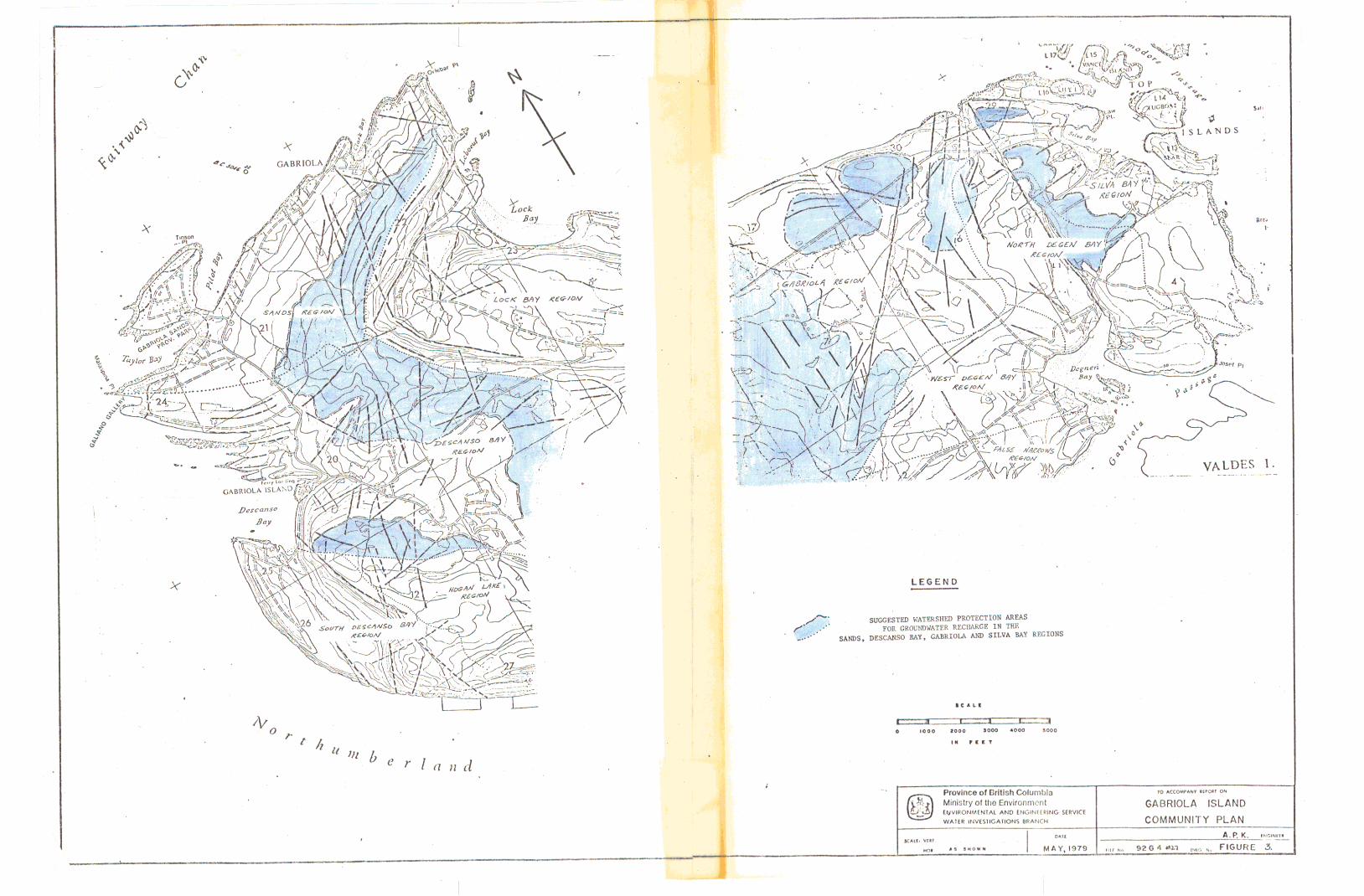
There i s in su f f i c i en t evidence t o indicate t h a t the four f a u l t areas designated above are important zones f o r groundwater recharge and t h a t they should be designated as Resource Protection Areas on this basis alone. In some areas i t would appear t h a t the designated f a u l t zones a re probably l e s s important for recharge than adjacent areas which have been designated Rural Areas ( i .e., i n Section 20). In view of the above, consideration should be g i v e n t o removing the f a u l t designated zones as Resource Protection Areas from the Communi ty P1 an and e x t e n d i n g water- shed protection zones to cover the upper reaches of the watersheds where groundwater recharge i s probably occurring. Figure 3 shows the water- shed boundaries (from Hodge, 1978) f o r the Sands, Descanso Bay, Gabriola and Si lva Bay Regions i n which the f a u l t designated zones a re located. In the Sands Region consideration should be given t o including the area above elevation 150 feet w i t h i n the Resource Protection Area. In the Descanso Bay Region elevations above 150 feet i n the northeast quarter of Section 20 should be protected and areas above 300 f e e t i n the remaining area of the watershed. elevation 125 f e e t should be protected and areas above 100 f e e t i n the S i lva Bay Region.
In the Gabriola Region, areas above
. . . . . . 5

- 5 -
0 REFERENCES
Badgley, P.C. 1965. S t ruc tura l and Tectonic Principles. Harper and Row, New York.
Brown, W . L . , and R . B . Erdman. 1975. Habitat of Groundwater, Gabriola Prepared for British Columbia Ministry Is land, British Columbia.
o f Environment by Robinson, Roberts and Brown Ltd.
Hills, E.S. 1963.. Elements o f Structural Geology. John Wiley and Sons Inc., New York.
Hodge, W.S. 1978. A Review of Groundwater Conditions on Gabriola I s 1 and. Water I nves t i ga t i ons Branch, Bri t i s h Col umbi a Mi n i s t r y of Environment .
Muller, J.E. and J.A. Jeletzky. 1970. Geology o f the Upper Cretaceous Nanaimo Group, Vancouver Island and Gulf Islands, British Columbia. Geol ogi cal Survey of Canada, Paper 69-25.
Schoeller, H.J. 1977. Analytical and Invest igat ional Techniques f o r Fissured and Fractured Rocks i n Groundwater Studies . An inter- national guide for research and prac t ice . UNESCO.
A.P. Kohut S r . Geological Engineer Groundwater Section Hydrology Division
APK/ j s
Attachs.

I .
i ! ! r
a>, a Resource Protealon Area (zoacre minimum io1 saze)
tt=1 Rura: (10 acre minimum iot size)
lzzzd Kural Residenrial ( 5 acre minimum lot size)
Major Roads - f? School
Nates. IIIThe above mlnlmum lot slzes are subject to tne condlllons contained
In tne text Of fhls plan
(2) The Rasource ProtectiGn Area incluaes lands In me following categorles Agriculturai Land Reserves Forest Areas Hoggan Lake watersned Special Areas Fault Zones
1; valdes \ island
Gabrlola Trust Committee January
.: . . . . . . . . . . . . . . . . .. . , ; . . . . . . . . _y . . . . . . . . . . . . . . . . . . . . .
. ” . .,.’ . , . .___ . . , ., . , .. . , . . . . 1 ,
I
, ’ F/G& 1. . ,
. . ....

!.,
L E G E N D
U I
S T R U C T U R A L LIN'EAMENT ( Includes faults,jolnts ond bedding t races I - -r - W A T E R S H E D BOUNDARY
A R E A S W H E R E C H L O R I D E C O N C E N T R A T I O N S IN GROUNDWATER E X C E E D 100 M G / L
D C A L L
0 1000 8000 aooo 4000 6000
I N F l C T
10 ACCOMPANY REPORI ON Province of British Columbia
ENVIRONMENTAL Ministry of the Environment AND ENGINEERING SERVICE
WATER INVESTIGATIONS BRANCH COMMUNITY PLAN GABRIOLA ISLA\
I .................................... ..... ~ ......_.._. ~ ...... ..... ~~~. .. ~. . .. .. ..A. p, K. .
~ ENGINEER
~ . . ._ . .. . .. .
I
LECEND -
.. praynn of Mlbh W m b l a 10 Y W M "em 01
GABRIOLA ISLAND Ministry of lb Environmcnl
W A l U I W S l G A I W N i MANO( COMMUNITY PLAN W V I ~ C N l U Awn tw.%t+ttRlNc IMWf