Embed Size (px)
Citation preview

Outline of scientific aims and data processing status of the first Hungarian hyperspectral data acquisition flight campaign,
HYSENS 2002 HUNGARY.
P. Kardevána, Z. Vekerdyb, L. Rótha, St. Sommerc, Th. Kemperc, Gy. Jordana, c, J. Tamásd, I. Pechmannd, E. Kovácsd, H. Hargitaie , F. Lászlóf
a Geological Institute of Hungary (MÁFI), Stefánia út 14, 1143 Budapest, Hungary, [email protected]
b International Institute for Geo-Information Science and Earth Observation (ITC), Division of Water Resources and Environmental Studies, P.O.Box 6, 7500 AA Enschede, the Netherlands,
c DG JRC, TP 262 Institute for Environment and Sustainability, Soil and Waste Unit, I-21020 Ispra (VA), Italy, [email protected]
d University of Debrecen, Centre of Agricultural Sciences (DE ATC), Dept. of Water and Environmental Management, D-4032 Debrecen, Böszörményi út 138. Hungary,
[email protected] e Eötvös Loránd University of Sciences, (ELTE TTK), Department of Physical Geography,
H-1117 Pázmány Péter sétány 1/C, Budapest, Hungary, [email protected] f Water Research Centre PLC, Institute for Water Pollution control, Kvassay Jenő út 1., H-1095
Budapest, Hungary
��������� Recent paper1 briefly summarizes the participant’s activities referring to the preparatory, planning and implementation phase of the first Hungarian airborne hyperspectral data acquisition project. The project was designed as an innovative action connected to former technology transfer and capability improvements in MÁFI within a broad domestic and international cooperation framework to contribute to the integration and utilization of remote sensing and geoscientific data in the GI sector in Hungary. Scientific aims outlined here were chosen carefully to support the elaboration of domestic case studies of reflectance and imaging spectrometry for a wide variety of application fields, and to support current and further cooperation with FP5 and FP6 project communities such as PECOMINES, Tisza River and MINEO. Target areas were selected with a view of developing them into a suitable test area with a corresponding GIS database of complementary scientific data. Problems, preliminary results and data processing status are shortly explained. Keywords: airborne, hyperspectral, imaging spectrometry, mining pollution, water quality, environmental assessment, land cover, plant stress, agriculture. ������ ����In confining our retrospective view to the Hungarian process of using spectral information acquired by various Earth observation techniques detecting the sunlight reflected from the surface, we can establish that by the end of the 1980’s high level of experience was gathered in the utilization of airborne colour and CIR photos in hydrological, agricultural and geological research. Practice and interpretational skill were based on interactive interpretation of images on paper sheets at this stage (See for instance [1], [2]).
The investigation of the high resolution spectral characteristics of rocks, soils and vegetation cover began just before the time of change in the political system causing the initial efforts to be ceased soon by the collapse of former market infrastructure and cooperation framework such as INTERCOSMOS (See for instance [3], or [4]). Results were emerging in the form of doctoral theses at universities [5], [6], [7] at that time. The development of advanced remote sensing methods in Hungary in the last decade was connected partly to space research but mainly to the application of satellite images of medium or low spatial and spectral resolution. The Space Research Group of Eötvös Loránd University carried out a systematic development of remote sensing methods from 1980 by elaborating a theoretical foundation of EM wave propagation in the atmosphere resulting in new atmospheric correction and crop monitoring models [8], [9], [10], [11], [12]. The Institute of Geodesy, Cartography and Remote Sensing (FÖMI) has been the basis institution in INTERCOSMOS and later in the ESA cooperation. Its development activity was mainly focused on land cover (CORINE) and crop monitoring (See for instance Ref. 13 and 14).
�������������������� ��� ����������������������������������������������������� ��!""��
324

In these days, remote sensing related projects were carried out in several institutes focusing on different application fields like soil science (Hungarian Soil Sciences and Agrochemical Research Institute, TAKI) or hydrology (Water Resources Research Institute, VITUKI) [2].
The Geological Institute of Hungary (MÁFI) joined main stream developments of integrated GIS and RS raster data processing systems as of the middle of 90s [15], [16]. Although by that time MÁFI had a strong GIS group for map publishing with state of the art SW/HW tools for digitising and processing of vector files, a series of capability improvements had been carried out to establish raster image processing skills [17]. The main factors of the difficulties and time consuming character of this process may have been the need for a basic mathematical knowledge including the expertise in spatial statistics and image processing and the interdisciplinary character of this new scientific branch. Also, a key factor of getting the applicability of advanced imaging spectroscopy successfully appreciated by the domestic market players was the availability of domestic case studies in Hungary. All these factors determined the cooperation strategy of MAFI, both in the country and abroad, which included among others the establishment of a scientific cooperation framework between MÁFI, ITC and VITUKI for the implementation of spectrometric field investigations of the soil characteristics of the Great Hungarian Plain and the detectability of the Baia Mare pollution event [18], the execution of concerted actions together with the Debrecen University, Centre of Agricultural Sciences, in establishing a PhD school on remote sensing that ultimately have lead to a successful application for the Hungarian project of the HYSENS 2002 hyperspectral flight campaign carried out by DLR.
As in Hungary no spectroradiometer working in the spectral range of 1,3-2,5µ is currently available, strong ground truth and field measurement support was given by ITC and the Soil and Waste Unit, IES of JRC to MÁFI Remote Sensing Group coordinating the HYSENS 2002 project. The Hungarian flight campaign covered 3 different regions separated by around 80-100km from each other, thus at last we received extra assistance for in-flight calibration measurements form the Imaging Spectroscopy Working Group of the Remote Sensing Data Centre of DLR as well.
���������������������������������
In Hungary, two internationally registered pollution sites of former mining activities (hot spots) are known in the Mátra mountains causing serious heavy metal pollution and acid mine drainage in the region. The damages caused by the sometime polymetallic ore mining in the region of the villages Recsk and Gyöngyösoroszi severely affect a group of villages. The remediation of the pollution is a timely scientific, technical and political issue.
Also, in 2000, the eastern, flat part of Hungary – the Tisza river basin – has been struck by several pollution accidents being in close connection with the gold mining activity of the neighbouring Romania. These cases raised the need of solving the problems associated with the catastrophic mining pollution and mitigating the risk of such events. The Mátra region proved to be an ideal test area to be selected for that problem as well.
Surface waters distribute the pollution waves from the mining sites. According to the original planning, the flood plains of the Tisza river were selected for the imaging spectrometry campaign, but subsequent large floods covered the polluted sediments with less polluted ones, so finally a tributary of the Tisza, the Sajó River was selected as the water quality and floodplain pollution site.
Several EU FP5 projects are dealing with these problems including PECOMINES and the Tisza River Project in which MÁFI participates. The former is for the compilation of a suitable inventory of hot spots and the characterization of them partly by RS methods, and the latter seeks the integration of hot spots RS characterization (LANDSAT, ASTER) technique with the water quality modelling of hilly regions. The clustering of Tisza River and MINEO projects was also initiated planning first the verification of MINEO technology as an accredited procedure that could be deployed in the monitoring and assessment of mining pollution risks of the surrounding countries around Hungary.
The former role and the currently strong commitment of DE ATC to the introduction of remote sensing methods in the agricultural sciences in Hungary (water- and environmental management, soil classification, precision farming) made is inevitable the selection of agricultural land target areas. These third type of target regions included a mixed area of commercial farm and natural protected area, and the Experimental Farm Látókép with multifactorial long-term plant cultivation experiments.
325

�����������������������
�������������� ��! "�
The geochemical processes and problems are the following [18],[19]: during more than hundred years of ore mining (hydrothermal copper and lead-zinc ore bodies) in the Mátra Mountains, great amounts of ore-bearing and non-ore bearing rocks were disposed in waste rock piles around the mining areas. They contain considerable amount of heavy metals or compounds of heavy metals. The heavy metals are leached by the precipitation from the waste rock piles; as a result they get into the soil, the groundwater and the surface waters. The ore mined in shallow depth contained considerable amount of pyrite. That can also be found in waste rock originated from ore milling. The following chemical process is taking place in the nature in such circumstances:
Fe S2 + (15/4) O2 + (7/2) H2O ⇒ Fe (OH)3 + 2H2SO4
Mining exposes sulphide minerals and accelerates weathering process. There is no material in waste rock piles in the proposed survey area that is capable to neutralise the sulphuric acidic impact.
The precipitation water saturated by dissolved oxygen, containing also sulphur-dioxide and various nitrogen-oxides has an acidic character, and can infiltrate easily through the waste rock piles, that are non re-mediated. The great amount of pyrite and other heavy metal sulphides in the wastes rock piles oxidise under the effect of oxygen rich, acidic precipitation water, and sulphate ions are formed, which have a strong acidic effect in the siliceous rock as described by the equation above. The heavy metal sulphides convert into oxy-hydroxides in this oxidation process, that are poorly soluble in water but even better then sulphides. In slightly acidic medium of the precipitation, the solution of heavy metal hydroxides better by several orders of magnitude, than the heavy metal sulphides. Enough oxygen gets into the system for fuelling the activity of sulphur and iron-oxidising microorganisms, and through their activity ferric-hydroxides and sulphate ions are formed and makes the system acidic, so the ferric-oxi-hydroxides convert into ferric ions. As a result, measured pH values are ranging between 2.2-4.4 in the groundwater samples collected in the vicinity of waste rock piles. These waters are sufficiently acidic to leach considerable amount of heavy metals from the waste rock piles
The main purpose of the data acquisition was to provide material for methodology development in using hyperspectral data in environmental impact assessment and monitoring. The focus is on the synergy of the hyperspectral data with existing geo-chemical and hydrological information and the determination of the possibilities and limitations of imaging spectrometry techniques to derive spatially distributed information about soil and water contamination due to the impact of metal mining. In particular the detection of specific trace minerals, typical of characteristic geochemical processes related to the alteration and weathering of sulphide mining waste materials, will be investigated at catchment level. Processes such as pyrite oxidation lead to acidification, mobilisation of heavy metals and formation of typical trace minerals such as iron sulphates (e.g. Jarosite), Gypsum, secondary clay minerals and precipitation of heavy metal bearing ferric-oxi-hydroxides. Typically the migration of these components is closely linked to the hydrological cycles in the affected catchment resulting in transport and dissemination of contaminants down-stream affecting riverbeds as well as soils and sediments in the flood plain.
The major task of the research in this area is the mapping of mine waste pollution around the waste dumps of a closed copper mine and along the valley of the Toka Creek, which drains the valley of the mine.
In this area, exploitation of copper ores (Enargite, Lusonite), occurrence of dumps and waste rock piles, ore dressing and concentration plant, tailings, ponds represent the problem. Contamination exists from lead, zink, copper, arsenic, iron, cobalt, as well as from mercury, nickel, cadmium etc.
�������!�#��$���%�#�!"��!� ��&��#%"'���
In the Recsk region, basically the acid mine drainage causes the majority of problems (Fig. 1) [20]. In the area of the actual mining managing company at Recsk (Recsk Ore Mine Co.- ROM Co.), there are numerous small water streams (Baláta Stream, Kata-rét Stream, Bikk Stream) together with the "Kincstár" Lake, which is a pond constructed for ensuring the water supply of flotation ore milling. The discharging water of small streams and that of Kincstár Lake is collected by the Parádi-Tarna Stream. This water is used as irrigation water in the plant cultivation period, 25 km downstream from the mines. In the area of ROM Co, on the banks of small streams and the Kincstár Lake, and its vicinity, 11 waste rock piles have been developed during the past 130 years of mining activity, containing chunk rock, ore and flotation waste.
326

Figure 1. From mining areas sulphide mining waste is carried away by surface waters causing AMD.
The groundwater level is higher by some cm-s than the surface water levels of most streams at medium water levels, thus, the condition for water flow from the waste rock piles to the streams is given. The great majority of dissolved heavy metals rapidly precipitates from the water of streams and connected to ferric-hydroxides being present in large amounts in the deposits on sites of lower current speeds. These sediments are distributed during the release of temporarily stored mine water of Kincstár Lake.
�������!�#��$���%�#�!(��!� ��&��$#���'����##'��#"���!�#�)�*+ ,*+"���"(!-�
The surface geochemical features are basically determined by the characteristics of the known poly-metallic Pb, Zn, Au, Cu ore mineralization at Gyöngyösoroszi [21]. In the creek sediment near Gyöngyösoroszi, concentrations of As, Cd, Hg, Pb and especially Zn are high and anomalous. The sources of these metals are: waste material of the Gyöngyösoroszi base metal mine, the mine water, the ore-dressing and the flotation waste dumps (Fig. 2).
Figure 2. The Cleaner pond in Gyöngyösoroszi. The heavy metal accumulated in the upper thin sludge layer
consisting of Fe(OH)3 (limonite) See vertical profile of the outlet construction (on the left) with a horizontal tunnel through which the pond is intermittently drained.
The contamination is deposited along the Toka Creek in its flood sediments. During floods, the mud with high heavy metal content, which had accumulated in the reservoirs, was also carried away and spread out. The heavy metal accumulated in the upper thin sludge layer consisting of Fe(OH)3 (limonite). The heavy metals substitute the Fe elements in the limonite (copercipitation). In the sixties, an accidental collapse of the lowest tailing flooded the downstream area with the flotation waste. The sand fraction was deposited near the bed as long and narrow sand bars (the so called 'yellow sand') and the finer fraction accumulated in other parts of the flood plain. The main problem of the area is the presence of polluted soils on the flood plain. Floods carry flotation material to great distances (>10km) from its source and there is no significant attenuation of the metal content of this material downstream.
327

Figure 3. Flotation tailing above Gyöngyösoroszi. This part is not recultivated, so the waste material is exposed to the air. Due to the very fine grain size, surface water ponding occurs from rains.
The land use of the Toka Creek Valley is mainly agriculture. In the upper part of the catchment, the waste dumps have been 'recultivated' by applying a thin soil cover layer, but open surfaces with clogged water can be found on them too. Some parts of the cover layer have been affected by rill erosion.
��������./��!0#���
The valley of the Sajó River is one of the most contaminated flood plains in Hungary. The source of the contamination is mainly the heavy industry along the upstream reaches of the river. Field investigations showed that the mineralization of the contaminants on the flood plain makes it possible to use this area as a test site for mining-related pollution, according to our original plans. The bulk of the contamination was deposited in the last 40 years. Recently, the low-tech heavy industry has been closed down in the upstream areas, so the water quality of the river reached acceptable contamination levels.
The width of the frequently inundated area is about 2 km, so it is possible to take both the contaminated and the non-affected (background) areas into one flight line. The flight line of the hyperspectral campaign contains the confluence of the Hernád River and the Sajó River too. As it was expected, due to the differences in the type of pollution in the headwater areas of the two rivers, the deposits downstream from the confluence show different spectral characteristics from the upstream floodplain.
Due to the topography, no dikes are built along the Sajó River. The flood plain is covered mostly with grasslands, with a few patches of forests. There are some lakes in the selected area: one oxbow lake and a few gravel pits filled with water.
A flight along a line of about 12 km length with an imaging altitude of 3500 m (7 m pixel size with DAIS and 1.5 m pixel size with ROSIS) was completed .
�����,�!%�1����1�1� 2���#�"�333��#,!� ��#4�#%# ��
As ITC and DE ATC being interested in studies referring to agricultural land we have chosen 2 typical areas in the Great Hungarian Plain near Debrecen, one of them being an experimental farm (Látókép) for long-term plant cultivation studies, the other also intensively cultivated farm region neighbouring natural protection park area (Tedej). At the Látókép Experimental Farm the effect of crop production factors on maize, sunflower, potato were studied on homogeneous Chernozem soil with lime deposit between 1989-2002 (Fig. 4). The multi-factorial long-term experiment made it possible to evaluate the interactions of fertilization – soil cultivation – irrigation and hybrids [22]. The extention of the Tedej target area is 1500 hectare, some of its part is “the puszta” or abutting to it. At the Tedej area, the soil categories characteristic to the Great Hungarian Plain can be found: Chernozem, Phaeozems, Solonchaks, Solonetz and their subspecies: calcareous Pheozems, non calcareous alkaline at depth, and Solonetz at depth [23].
Figure 4. Látókép Experimental Farm (Composite image from DAIS data cube)
328

(A) (B) Figure 5. Genetic soil map with the main soil categories and their sub-categories: Chernozem, Phaeozems, Solonchaks, Solonetz and calcareous Pheozems, non calcareous alkaline at depth, and Solonetz at depth (A); The cartogram of soil forming minerals: sandy silt, loess, silty clay, clayey silt, sandy loess (B).
5��������������6 ��������������7���������������
Soil, water and stream bed samples have been collected for mine-originated contamination analysis by ITC, JRC, MAFI and Debrecen University. An ASD FieldSpec, a GER 3700 and a PIMA spectrometers were available for the field spectral measurements. 50 soil samples were analysed in ITC for heavy metal content. Field and laboratory spectra were taken from the same samples to establish correlation between the samples and the images.
The JRC Hysens Team measured field spectra (see Fig 6 and 7) and collected 63 soil samples from the top of waste rock dumps and tailings heaps in Recsk and Gyöngyösoroszi mining areas and measured field spectra. The 2 kg samples were collected from the uppermost 1 cm of dumps. At each sampling location: position was determined by GPS; digital photo of undisturbed surface taken; 4 field hyperspectral measurements taken in an about 50cmx50cm rectangle area; solid samples collected using plastic tools, then thoroughly homogenized on site, and devided into two plastic zip-loc bags: one for JRC, one for MAFI. Scientific objective of sampling was many-fold: to re-measure the spectra in lab conditions at JRC; measuring metal content with XRF, and ICP-MS in JRC Labs; analysing mineral composition with XRD and DTA at MAFI Labs; using results as ground-truth data for the airborne hyperspectral images. Samples for mineral analysis were left at MAFI after field campaign. Samples taken to JRC were dried and measured for spectra. The samples also have been dried, seeved and stored for latter chemical analysis. Field GPS measurements have been processed and final high-accuracy co-ordinates of field measurement locations have been stored in a database. All filed and lab spectral measurements have been processed, i.e. calibrated, filtered for errors, etc. A spectral library has been developed. Field data collection was done by using NITON XL-700 field portable X-ray fluorescent spectrometer by DE ATC.
Figure 6. Measuring and sampling sites of JRC team in Gyöngyösoroszi (image: DAIS color composit RGB=Bands 3, 13, 8)
329

Figure 7. Field spectra measured and pictures taken at G3 sampling sites (Dried tailings ponds, See Fig 6) in Gyöngyösoroszi.
In the Sajó floodplain: soil (140) and water (25) samples were taken by JRC and analysed for several parameters (heavy metal content; TSM, chlorophyll-a, etc.). The field measurements were carried out here in a one-month field campaign. Field and laboratory spectra were taken from the same samples to establish the correlation with the images. Emphasis was laid on the study of the potential of hyperspectral data in monitoring heavy metals contaminated vegetation, to detect phytotoxic effects, to analyse inhomogeneous spatial distribution of contaminants and to provide data for migration analysis of heavy metals as a result of erosion. Experiment has been started to apply HYSENS data in agricultural long term experiences and in soil classification as well. Images were taken from three test site groups (five test sites): In Agricultural areas soil samples were collected for the determination of salinity, reed samples were collected for base-line study from non-contaminated areas by ITC. The data were analysed in the second half of 2002 and the first results have been published in 3 MSc theses during March 2003. Further analysis is planned, and a new field campaign will be carried out in 2003 to strengthen and verify the spectral models used for the image processing.
The Debrecen University compiled GIS including air photos, maps, and supporting data for crop sub species, irrigated and non irrigated areas, different fertilizer doses (nitrogen, phosphorous, potassion), and different soil tillage methods in Látókép Enxperimental Farm. They integrated crop data sources in GIS, which includes also remote sensing and digital air photo maps, setup background data base for soil degradation especially secondary salinization processes, for agricultural land use, for irrigated and non irrigated crop environment, for distinguishing between impacts of different wheat control, for distinguishing nitrate pollution in Tedej area.
MÁFI has given overall coordination to the airborne flight and the field activities, moreover has undertaken laboratory analysis of soil samples. One of the tasks completed by MÁFI in the course of pre-processing of DAIS images was acquisition of underlying DEMs, air photos and location maps geo-rectified in UTM. The Hungarian team members process hyperspectral data by ERDAS IMAGINE 8.6 (DE ATC) and ENVI 3.6 (MÁFI). While the conversion between UTM and the Hungarian Unified Projection (EOV) is enabled by IMAGINE 8.6 as a built-in option, ENVI had to be upgraded. As known from the literature [24],[25], the global (WGS84 or ETRS89) and local Hungarian reference ellipsoids (HD72) can be mutually transformed to each other by the standard Helmert- transformation. ENVI permitted however the user definition of 3 transformation parameters of the local reference ellipsoid thus the Molodensky-Badekas 3-paramater datum transformation had to be used and was built in the software [26].
330
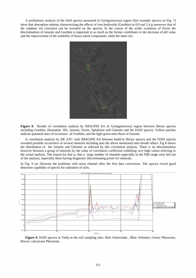
A preliminary analysis of the field spectra measured in Gyöngyösoroszi region (See example spectra on Fig. 7) show that absorption minima characterizing the effects of iron hydroxide (Geothite) at 0,9 and 1,4 µ moreover that of the sulphate ion (Jarusite) can be revealed on the spectra. In the course of the acidic oxidation of Pyrite the discrimination of Jarusite and Goethite is important in as much as the former contributes to the decrease of pH value and the improvement of the solubility of heavy metal compounds, while the latter not.
Figure 8. Results of correlation analysis by IMAGINE 8.6 of Gyöngyösoroszi region between library spectra including Goethite, Heamatite, Illit, Jarusite, Pyrite, Sphalerite and Galenite and the DAIS spectra. Yellow patches indicate potential sites of occurence of Goethite, and the light green ones those of Jarusite.
A correlation analysis by DE ATC with IMAGINE 8.6 between build-in library spectra and the DAIS spectra revealed possible occurrence of several minerals including also the above mentioned ones beside others. Fig 8 shows the distribution of the Jarusite and Ghoetite as selected by this correlation analysis. There is no discrimination however between a group of minerals by the value of correlation coefficient exhibiting very high values referring to the actual analysis. The reason for that is, that a large number of channels especially in the NIR range were left out of the analysis, especially those having diagnostic discriminating power for minerals.
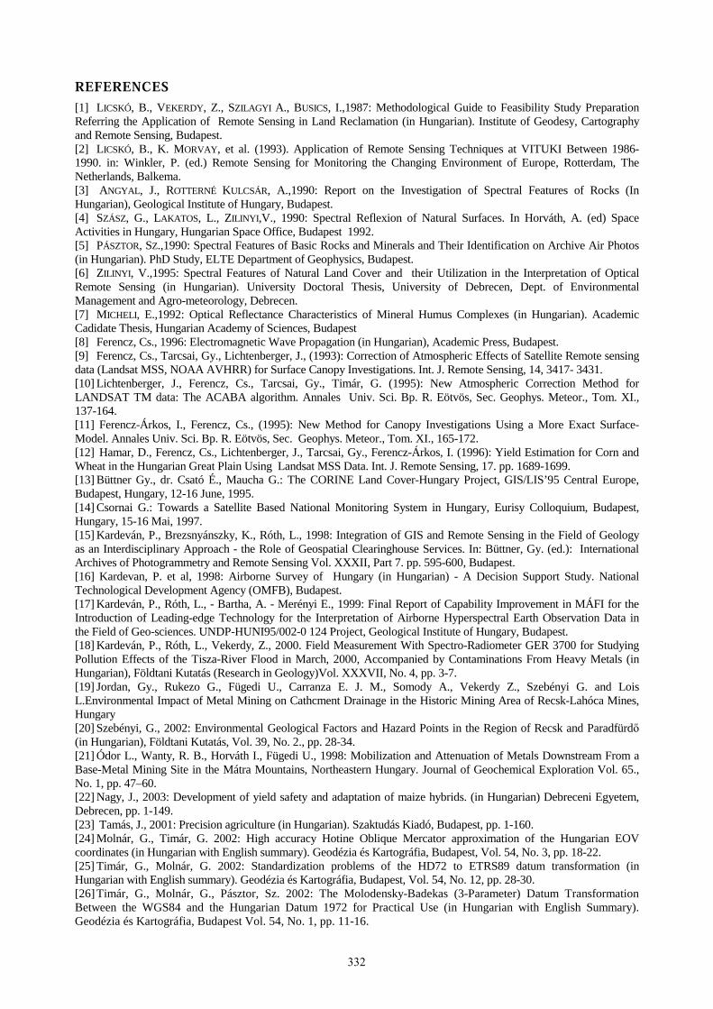
In Fig. 9 we illustrate the problems with noisy channel after the first data corrections. The spectra reveal good detection capability of spectra for salination of soils.
Figure 9. DAIS spectra in Tedej at the soil sampling sites. Red: Solonchaks , Blue: Solonetz, Green: Phaozems, Brown: calcareous Pheozems.
331
����������
[1] LICSKÓ, B., VEKERDY, Z., SZILAGYI A., BUSICS, I.,1987: Methodological Guide to Feasibility Study Preparation Referring the Application of Remote Sensing in Land Reclamation (in Hungarian). Institute of Geodesy, Cartography and Remote Sensing, Budapest. [2] LICSKÓ, B., K. MORVAY, et al. (1993). Application of Remote Sensing Techniques at VITUKI Between 1986- 1990. in: Winkler, P. (ed.) Remote Sensing for Monitoring the Changing Environment of Europe, Rotterdam, The Netherlands, Balkema. [3] ANGYAL, J., ROTTERNÉ KULCSÁR, A.,1990: Report on the Investigation of Spectral Features of Rocks (In Hungarian), Geological Institute of Hungary, Budapest. [4] SZÁSZ, G., LAKATOS, L., ZILINYI,V., 1990: Spectral Reflexion of Natural Surfaces. In Horváth, A. (ed) Space Activities in Hungary, Hungarian Space Office, Budapest 1992. [5] PÁSZTOR, SZ.,1990: Spectral Features of Basic Rocks and Minerals and Their Identification on Archive Air Photos (in Hungarian). PhD Study, ELTE Department of Geophysics, Budapest. [6] ZILINYI, V.,1995: Spectral Features of Natural Land Cover and their Utilization in the Interpretation of Optical Remote Sensing (in Hungarian). University Doctoral Thesis, University of Debrecen, Dept. of Environmental Management and Agro-meteorology, Debrecen. [7] MICHELI, E.,1992: Optical Reflectance Characteristics of Mineral Humus Complexes (in Hungarian). Academic Cadidate Thesis, Hungarian Academy of Sciences, Budapest [8] Ferencz, Cs., 1996: Electromagnetic Wave Propagation (in Hungarian), Academic Press, Budapest. [9] Ferencz, Cs., Tarcsai, Gy., Lichtenberger, J., (1993): Correction of Atmospheric Effects of Satellite Remote sensing data (Landsat MSS, NOAA AVHRR) for Surface Canopy Investigations. Int. J. Remote Sensing, 14, 3417- 3431. [10] Lichtenberger, J., Ferencz, Cs., Tarcsai, Gy., Timár, G. (1995): New Atmospheric Correction Method for LANDSAT TM data: The ACABA algorithm. Annales Univ. Sci. Bp. R. Eötvös, Sec. Geophys. Meteor., Tom. XI., 137-164. [11] Ferencz-Árkos, I., Ferencz, Cs., (1995): New Method for Canopy Investigations Using a More Exact Surface-Model. Annales Univ. Sci. Bp. R. Eötvös, Sec. Geophys. Meteor., Tom. XI., 165-172. [12] Hamar, D., Ferencz, Cs., Lichtenberger, J., Tarcsai, Gy., Ferencz-Árkos, I. (1996): Yield Estimation for Corn and Wheat in the Hungarian Great Plain Using Landsat MSS Data. Int. J. Remote Sensing, 17. pp. 1689-1699. [13] Büttner Gy., dr. Csató É., Maucha G.: The CORINE Land Cover-Hungary Project, GIS/LIS’95 Central Europe, Budapest, Hungary, 12-16 June, 1995. [14] Csornai G.: Towards a Satellite Based National Monitoring System in Hungary, Eurisy Colloquium, Budapest, Hungary, 15-16 Mai, 1997. [15] Kardeván, P., Brezsnyánszky, K., Róth, L., 1998: Integration of GIS and Remote Sensing in the Field of Geology as an Interdisciplinary Approach - the Role of Geospatial Clearinghouse Services. In: Büttner, Gy. (ed.): International Archives of Photogrammetry and Remote Sensing Vol. XXXII, Part 7. pp. 595-600, Budapest. [16] Kardevan, P. et al, 1998: Airborne Survey of Hungary (in Hungarian) - A Decision Support Study. National Technological Development Agency (OMFB), Budapest. [17] Kardeván, P., Róth, L., - Bartha, A. - Merényi E., 1999: Final Report of Capability Improvement in MÁFI for the Introduction of Leading-edge Technology for the Interpretation of Airborne Hyperspectral Earth Observation Data in the Field of Geo-sciences. UNDP-HUNI95/002-0 124 Project, Geological Institute of Hungary, Budapest. [18] Kardeván, P., Róth, L., Vekerdy, Z., 2000. Field Measurement With Spectro-Radiometer GER 3700 for Studying Pollution Effects of the Tisza-River Flood in March, 2000, Accompanied by Contaminations From Heavy Metals (in Hungarian), Földtani Kutatás (Research in Geology)Vol. XXXVII, No. 4, pp. 3-7. [19] Jordan, Gy., Rukezo G., Fügedi U., Carranza E. J. M., Somody A., Vekerdy Z., Szebényi G. and Lois L.Environmental Impact of Metal Mining on Cathcment Drainage in the Historic Mining Area of Recsk-Lahóca Mines, Hungary [20] Szebényi, G., 2002: Environmental Geological Factors and Hazard Points in the Region of Recsk and Paradfürdő (in Hungarian), Földtani Kutatás, Vol. 39, No. 2., pp. 28-34. [21] Ódor L., Wanty, R. B., Horváth I., Fügedi U., 1998: Mobilization and Attenuation of Metals Downstream From a Base-Metal Mining Site in the Mátra Mountains, Northeastern Hungary. Journal of Geochemical Exploration Vol. 65., No. 1, pp. 47–60. [22] Nagy, J., 2003: Development of yield safety and adaptation of maize hybrids. (in Hungarian) Debreceni Egyetem, Debrecen, pp. 1-149. [23] Tamás, J., 2001: Precision agriculture (in Hungarian). Szaktudás Kiadó, Budapest, pp. 1-160. [24] Molnár, G., Timár, G. 2002: High accuracy Hotine Oblique Mercator approximation of the Hungarian EOV coordinates (in Hungarian with English summary). Geodézia és Kartográfia, Budapest, Vol. 54, No. 3, pp. 18-22. [25] Timár, G., Molnár, G. 2002: Standardization problems of the HD72 to ETRS89 datum transformation (in Hungarian with English summary). Geodézia és Kartográfia, Budapest, Vol. 54, No. 12, pp. 28-30. [26] Timár, G., Molnár, G., Pásztor, Sz. 2002: The Molodensky-Badekas (3-Parameter) Datum Transformation Between the WGS84 and the Hungarian Datum 1972 for Practical Use (in Hungarian with English Summary). Geodézia és Kartográfia, Budapest Vol. 54, No. 1, pp. 11-16.
332


![Southampton Open Wireless Network. Talk outline Aims of SOWN Technical Outline Campus nodes Servers SOWN[at]HOME nodes What would I have](https://img.dokumen.tips/doc/110x75/56649eff5503460f94c14f3f/southampton-open-wireless-network-wwwsownorguk-talk-outline-aims-of-sown.jpg)