Embed Size (px)
Citation preview

Aut
hor C
opy
• Aut
hor C
opy
• Aut
hor C
opy
• Aut
hor C
opy
• Aut
hor C
opy
• Aut
hor C
opy
• Aut
hor C
opy
• Aut
hor C
opy
• Aut
hor C
opy
Pol. J. Environ. Stud. Vol. 29, No. 5 (2020), 1-10
Original Research
Quantitative Contribution of Climate Change and Land Use Change to Runoff in Tarbela
Catchment, Pakistan
Rana Shahram Shaukat1, Mudasser Muneer Khan1, Muhammad Shahid2, 3*,
Muhammad Shoaib4, Tanveer Ahmad Khan1, Muhammad Asif Aslam1
1Department of Civil Engineering, University College of Engineering and Technology, Bahauddin Zakariya University, Multan, Pakistan
2State Key Laboratory of Hydroscience and Engineering, Department of Hydraulic Engineering, Tsinghua University, Beijing, China
3NICE, SCEE, National University of Sciences and Technology, Islamabad, Pakistan4Department of Agricultural Engineering, Bahauddin Zakariya University, Multan, Pakistan
Received: 6 July 2019Accepted: 8 September 2019
Abstract
Estimating the quantitate contribution of climate and land use change is necessary for planning water resources. Tarbela catchment in Pakistan was selected for this study. The Mann Kendall and Pettit test has been used for trend analysis of hydro climatic variables. Original climate elasticity method and improved empirical model of precipitation have been used. The results of trend analysis showed that precipitation and runoff trends decreased and potential evaporation trends increased. The annual rainfall and runoff presented a change point around the years 1999 and 1994 respectively. According to change point analysis, the runoff series was divided into two parts. The period before change point has been regarded as the pre-change period and the period after change point has been regarded as the post change period. According to the original climate elasticity method, the relative contribution of climate change and land use change has been computed as 39.3% and 60.7% respectively. Similarly the improved empirical model of precipitation showed relative contributions of climate change as 41.7% and the same for land use change as 58.3%. To validate the land use change contribution we prepared land use maps. It can be concluded that land use and climate change are responsible for runoff change in Tarbela catchment, and both methods performed well and results are in agreement.
Keywords: runoff change, attribution, climate change, Tarbela dam, Pakistan, water resources
*e-mail: [email protected]
DOI: 10.15244/pjoes/112214 ONLINE PUBLICATION DATE:
Shaukat R.S., et al. 2A
utho
r Cop
y • A
utho
r Cop
y • A
utho
r Cop
y • A
utho
r Cop
y • A
utho
r Cop
y • A
utho
r Cop
y • A
utho
r Cop
y • A
utho
r Cop
y • A
utho
r Cop
y
Introduction
Water is the most important element for all living things. During the past few decades water scarcity has become a global challenge [1-2]. The World Economic Forum report of 2015 identified the water crises as the first high-impact risk for current times. The International Hydrological Program focuses on water security and its availability on regional and global scales, and addressing water scarcity and quality is its sixth theme. Runoff is the main source of water availability for our environment and it is produced by the interaction of climate change and land use change [3]. The spatial distribution of runoff changes due to climate change as it changes the spatial and temporal distribution of precipitation. It has been concluded in different research studies that precipitation and temperature patterns of different regions have been changed due to alterations in the hydrological cycle that have occurred due to land use. The increasing temperature also changes the distribution of runoff [4], and as has been observed during the past few decades, global temperature has increased significantly [5]. Similarly, land use changes directly affect the process of flow generation, which significantly changes runoff [6]. Researchers have concluded that half of the global surface and subsurface water has been used by humans, and due to a recent increase in agriculture and industrial activities this demand is increasing day by day [7]. Land use changes are mainly due to human activities in a basin, which directly affect the flow mechanism of a river. Due to land use changes and human activities in source areas, the flow decreases in upper and middle reaches of a basin, which directly impacts the runoff regime in lower parts of the basin and cause water shortage [8, 9]. Human and development activities in a catchment area change the regime of runoff by affecting the infiltration capacity. The size and peek of flood wave is also land use sensitive, and land use changes also impact flood timings. However, the impact of these land use changes vary at the regional level [10-12]. Moreover, the quantification of relative contribution of the climate change and land use change impacts on runoff generation is important for arid and semi-arid regions [13]. Therefore, understanding the hydrological cycle is important at the regional level.
Globally, many studies have been performed to understand the impact of land use change and climate change on runoff generation, and various methods have been adopted [14-18]. These methods include hydrological modeling, statistical techniques and paired catchment techniques. All these methods have merits and demerits. For example, the hydrological modeling method uses mostly distributed, lumped and dynamic models. The calibration and validation of these methods requires a large number of datasets, which is why it is hard to use them in a basin with limited information. However, the uncertainties and discrepancies exist in results of every method and
model. The empirical methods have been proposed for attribution purposes and these methods test sensitivity of streamflow to climate change. The empirical methods have been used in different parts of the world and such methods have been found to be very helpful for runoff attribution [19-20]. The empirical method provides physical interpretation and has fewer data requirements. Therefore, such methods are referred to developing countries that have fewer resources to monitor the hydrological data. Different researchers have performed studies on the Indus River basin and concluded that flow changes are due to temperature and global climate change projections. The results also suggest that the impact of land use and climate changes have a serious impact on future water resources of Pakistan’s water resources [21]. Tarbela dam is the first regulatory storage on the River Indus and the maximum of the annual Upper Indus River inflow stored at Tarbela. Tarbela Dam is the main source of water for Pakistan. Agricultural productivity is very dependent on this reservoir. Moreover, the power supply of the country is also dependent on this reservoir. This is the first attempt to understand the impact of climate and land use change in the Indus basin – especially Tarbela Catchment. Accordingly, this study presents and compares the results from two statistical methods: the original climate elasticity method and improved empirical model of precipitation method to evaluate the runoff change in Tarbela Catchment. The land use change and climate change impacts are considered as independent in the present study. The independent consideration of both factors has been used in previous
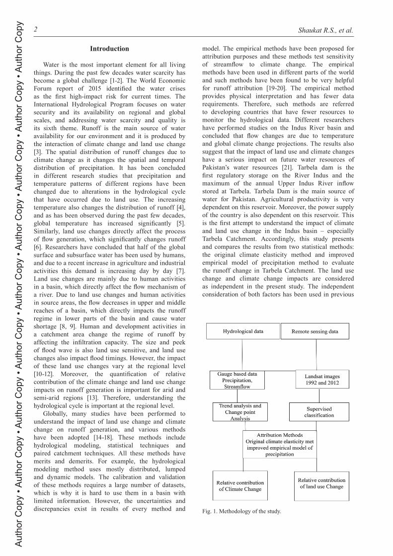
Fig. 1. Methodology of the study.

Quantitative Contribution of Climate... 3A
utho
r Cop
y • A
utho
r Cop
y • A
utho
r Cop
y • A
utho
r Cop
y • A
utho
r Cop
y • A
utho
r Cop
y • A
utho
r Cop
y • A
utho
r Cop
y • A
utho
r Cop
y
studies [22-23]. The methodology adopted in this study is given in Fig. 1. The objectives of this study are: (1) to understand hydrological trends in Tarbela Catchment and (2) to evaluate the impacts of land use change and climate change on Tarbela inflow.
Material and Methods
Study Area
Pakistan is one of the most important countries of South Asia; mostly Pakistan is arid. The population of Pakistan is growing rapidly, which places stress on the natural resources of the country. Pakistan is among the water stressed countries now, per capita water is less than 1000 m3/year, and it is the seventh most vulnerable country in terms of climate change [24]. Tarbela dam is the main source of water supply to Pakistan. Agricultural productivity is very dependent on this reservoir. Moreover, the power supply of the country is also dependent on the catchment area of Tarbela Dam, which is shown in Fig. 2. The catchment area has been delineated by using Aster global digital elevation model and the catchment area of Tarbela is calculated as 162393 km2. The mean elevation of the catchment is 4750 m, and 60% of this area has elevation of 4500 m and 12% of this area has an elevation of 5500 m. The climate varies from north to south according to the latitude of the study area. The climate changes from subtropical to colder. The average rainfall
varies between 950 mm in the south to 1500 mm in the north. The trend of rainfall is monsoonal, the rainfall in the winter and autumn is more important. The rainfall in these seasons is effective due to lower temperatures. The rainfall in summer and spring seasons is torrential, and during this season the temperature remains high. Summer season varies from hot to very hot. The geology of Tarbela catchment area is loosely cemented sandstone and friable sandy shale. The soil here is sand, silt and clay. The physiography of the catchment area is hilly, with hills ranging between elevations of 500 m at the western end to 2200 m on its eastern end, which has an average height of 1000 m.
Data Description
Hydrological and meteorological data were collected for this study. The flow data was collected for Tarbela gauging stations of the surface water hydrology project section of the Water and Power Development Authority during 1980-2012. Then obtained data of streamflow was aggregated into annual mean and converted in (mm) [25].
3
2
/( )*(3600*24)( )*1000
mm Discharge m sDISCHARGEday Watershedarea m
=
(1)
Meteorological data including rainfall and temperature of different stations was collected during 1980-2012. Daily climatic data was collected from
Fig. 2. Catchment area of Tarbela Dam.

Shaukat R.S., et al. 4A
utho
r Cop
y • A
utho
r Cop
y • A
utho
r Cop
y • A
utho
r Cop
y • A
utho
r Cop
y • A
utho
r Cop
y • A
utho
r Cop
y • A
utho
r Cop
y • A
utho
r Cop
y
Astore, Gilgit, Gupis, Garhi dupatta, Darosh, Dir, Dhanyor, Saidu, Kotli, Muzafferabad, and Murree meteorological stations. The Pakistan Meteorological Department (PMD) stations are mostly at lower elevations, and only few stations of (PMD) measure climate data at higher elevation. The Glacier Monitoring Research Centre (GMRC) of WAPDA has installed stations at higher elevations, so we selected the (GMRC) stations with maximum duration and suitable condition for this study. Potential evapotranspiration (PET) is calculated by Penman equation using FAO guidelines. Inverse distance weighted method is used to estimate areal values, while potential evaporation and daily precipitation are spatially averaged across the study area. From a survey of Pakistan we obtained topographical information. Stream network and catchment boundaries are delineated on the basis of a digital elevation model.
Change Point and Trend Test Identification
There are many tests for trend detection, but a non-parametric test is preferred [26-27]. To detect trends in hydro-climatic variables, the Mann-Kendall test is mostly used [24]. The Mann-Kendall and Pettit change point tests have been used to identify trends and shifts in mean of time series. The MK test has two advantages, first it is a non-parametric test and normal distribution of data is not required. Secondly, in homogeneous data series this test is very sensitive to abrupt changes. In the MK test, the null hypothesis is represented by H0 and it is assumed that no trend is present in data series and that data is ordered independently. This null hypothesis is evaluated against an alternative hypothesis H1. In this alternative hypothesis H1 it is supposed that a trend is present in the data series. The calculation procedure of MK test includes the time series with n data points. Moreover, it also includes two sub data sets named Ti and Tj. Where i = 1,2, 3,…, n-1 and term j = i+1, i+2, i+3, …, n. The values present in data series are checked as they are ordered. Every data set is equaled with the subsequent data values. If the data sets in a later series are more than the data sets of an earlier time the value of S is increased by one. Similarly, if the data sets in a later series are lower as compared to earlier series, the S is decreased by one. The final value of the statistic S is computed from all these increments and decrements. The equation for Mk statistic S is:
( )1
1 1
n n
j ii j i
S sgn T T−
= = +
= −∑ ∑ (2)
( 01sgn( ) 0 (
1 0
)
(
)
)
0j i
j i j i
j i
ifi
Tf
T TT T T T
Tif
>
=
−
− =− <
−
− (3)
…where Tj and Ti are the annual values for years j and i respectively. If in the data sets n<10, the computed value for |S| is directly equal to the theoretical value of the term S, which is derived from the MK test. The test with two tails is used. If the calculated value of S equals or is increased from the specified value of Sα/2, the value of H0 is rejected for the term H1. If there is no trend the Sα/2 is the least S and it has a probability of less than α/2. The trend will be upward if term S has a positive value while the trend will be downward if term S has a negative value. If n≥10, term S is about normally distributed and it is represented as: E(S) = 0 and the variance for S can be given as:
2 ( 1)(2 5) ( )( 1)(2 5)18
in n n T i i i− + − − +σ = ∑
(4)
In this equation, term ti shows the ties up to the i. Zs is computed by using following equation:
[ ]1
00 [ 0]
1 [ 0]sZ
Sif Sif S
S if S
σ=
− >
=+ <σ
(5)
The significance in trend is evaluated by using the statistic Zs. This statistic is used to check the H0, which is null hypothesis. The null hypothesis is not valid if the value of |Zs| is greater compared to the value of Zα/2. Term α shows the selected significance level. If null hypothesis is not valid the trend will be considered as a significant trend and vice versa. There is another statistic Kendall’s tau which is obtained during the MK test. Kendall’s tau is used to calculate the correlation and it finds the power of relationship among the two variables that are tested. Kendall’s tau is based on data ranks for every variable and the values are ordered and then numbered. The lowest value is numbered as 1 and the next lowest value is numbered as 2 and so on. In data analysis is crucial to consider the serial correlation of data sets. Autocorrelation enhances the chances for detection, therefore modified Mann-Kendall test is used and the adjusted variation is computed by:
*[ ] 1/18[ ( 1)(2 5)] / ( )Var S N N N N NS= − + (6)
…where
*1
2/ ( ) 1 ( )( 1)( 2) ( )( 1)( 2)
p
iN NS N i N i N i s i
N N N == + − − − − − Ρ
− − ∑(7)
In this equation N represents the observation numbers, the term NS* represents the effective number of observations, and ρs(i) represents the
Quantitative Contribution of Climate... 5A
utho
r Cop
y • A
utho
r Cop
y • A
utho
r Cop
y • A
utho
r Cop
y • A
utho
r Cop
y • A
utho
r Cop
y • A
utho
r Cop
y • A
utho
r Cop
y • A
utho
r Cop
y
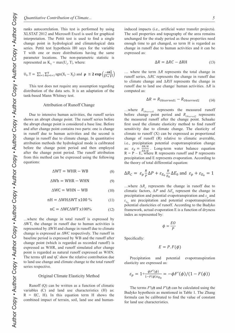
ranks autocorrelation. This test is performed by using XLSTAT 2012 and Microsoft Excel is used for graphical interpretation. The Pettit test is used to find a single change point in hydrological and climatological data series. Pettit test hypothesis H0 says for the variable T with one or more distributions having the same parameter locations. The non-parametric statistic is represented as KT = max|Ut, T|, where:
This test does not require any assumption regarding distribution of the data sets. It is an adaptation of the tank-based Mann Whitney test.
Attribution of Runoff Change
Due to intensive human activities, the runoff series shows an abrupt change point. The runoff series before the abrupt change point is considered a base line. Before and after change point contains two parts: one is change in runoff due to human activities and the second is change in runoff due to climate change. In quantitative attribution methods the hydrological mode is calibrated before the change point period and then employed after the change point period. The runoff attribution from this method can be expressed using the following equations:
(8)
(9)
(10)
(11)
(12)
…where the change in total runoff is expressed by ∆WT, the change in runoff due to human activities is represented by ∆WH and change in runoff due to climate change is expressed as ∆WC respectively. The runoff in baseline period is expressed by WB and the runoff after change point (which is regarded as recorded runoff) is expressed as WHR, and runoff simulated after change point is regarded as natural runoff expressed as WHN. The terms ηH and ηC show the relative contribution due to land use change and climate change to the total runoff series respective.
Original Climate Elasticity Method
Runoff (Q) can be written as a function of climatic variables (C) and land use characteristics (H) as: R = f(C, H). In this equation term H shows the combined impact of terrain, soil, land use and human-
induced impacts (i.e., artificial water transfer projects). The soil properties and topography of the area remains unchanged for the study period as these properties need enough time to get changed, so term H is regarded as change in runoff due to human activities and it can be expressed as:
(13)
… where the term ΔR represents the total change in runoff series, ΔRC represents the change in runoff due to climate change and ΔRH represents the change in runoff due to land use change/ human activities. ΔR is computed as:
(14)
…where RObserved1 represents the measured runoff before change point period and RObserved2 represents the measured runoff after the change point. Schaake first used the climate elasticity method to find runoff sensitivity due to climate change. The elasticity of climate to runoff (X) can be expressed as proportional change of runoff (R) relative to climatic averrable, i.e., precipitation potential evapotranspiration change as: . Long-term water balance equation R = P – E, where R represents runoff and P represents precipitation and E represents evaporation. According to the theory of total differential equation:
…where ΔRC represents the change in runoff due to climatic factors, ΔP and ΔE0 represent the change in precipitation and potential evapotranspiration and εp and εE0 are precipitation and potential evapotranspiration potential elasticities of runoff. According to the Budyko framework, actual evaporation E is a function of dryness index as represented by:
Specifically:
Precipitation and potential evapotranspiration elasticity are expressed as:
The terms F '(φ) and F '(φ) can be calculated using the Budyko hypothesis as mentioned in Table 1. The Zhang formula can be calibrated to find the value of constant for land use characteristics.

Shaukat R.S., et al. 6A
utho
r Cop
y • A
utho
r Cop
y • A
utho
r Cop
y • A
utho
r Cop
y • A
utho
r Cop
y • A
utho
r Cop
y • A
utho
r Cop
y • A
utho
r Cop
y • A
utho
r Cop
y
Improved Empirical Model of Precipitation
The empirical model only takes precipitation as a climatic factor. The equation for the improved empirical model can be expressed as:
(15)
In this equation Q represents runoff, P represents precipitation and PE represents the potential evapotranspiration k, meaning the kth year of runoff. The terms a, b and c are constants calculated by employing rainfall, runoff and potential evapotranspiration in the natural period. Using rainfall, runoff and potential evapotranspiration and equation above runoff Q is simulated. The 𝑄sim simulated runoff in the change period can be regarded to include climate change for change period while holding human impacts in the natural period. The difference of observed and simulated runoff will give a contribution of human activities during change period. The impact of climate change and human activities can be assessed as:
(16)
(17)
(18)
…where terms Cc and CH show the climate change impact and human activities, and terms ΔQC and ΔQH show the average change in runoff due to climate and human activities.
Land Use Classification
Land use classification has been performed and land use maps of the study area have been developed to validate the contribution of land use change to runoff change. The Landsat images of 1992 and 2012 have been downloaded and processed to get the land use maps of the study area. There are different methods to classify the land use images we used and the supervised classification method to develop the land use images
of the study area. The land use maps of 1992 and 2012 represent the land use situation of the study area before and after change point respectively. One-hundred training samples have been used for each class during the supervised classification method. The accuracy of classification has been performed by using the stratified random method. Ground truthing has been performed to validate 200 points. The validation has been performed by visual interpretation, and classification results are compared with the reference data by developing an error matrix. The kappa coefficient value is refereed to explain the classification results as it represents the agreement between classified data and actual ground data. Readers interested in detailed descriptions of the land use classification methods are referred to [28-29].
Results and Discussion
Trend Analysis of Runoff and Climate Variables
The Mann Kendal test was performed by using freely available software XLSTAT 2014. The test was performed for precipitation, potential evapotranspiration and runoff. The results of Mann-Kendal test are presented in Table 2. It can be observed that the precipitation trends are decreasing in the Tarbela catchment. The decreasing rate was calculated using linear regression and it is observed that the change rate for precipitation is 0.56%, which shows that there is a significant decrease in rainfall of the Tarbela catchment. The results of the Mann Kendal test for potential evapotranspiration shows that there is a significant increase in potential evapotranspiration of
Table 1. Different formulae for the Budyko hypothesis.
Expression F(φ) F'(φ)
Turc (1954); Pike (1964)
Zhang (2001)
Table 2. Trend analysis Results for annual runoff and climate variables (mm/year).
Variable Test Statistics
Precipitation(P) 5.3(0.56 %)*
(PET) 4.2 (0.95%)
Runoff 4.8(1.27%)*
Note: *indicates trend decrease at significance levels of 0.05. Slope is calculated by using linear regression. Change rate is shown in brackets

Quantitative Contribution of Climate... 7A
utho
r Cop
y • A
utho
r Cop
y • A
utho
r Cop
y • A
utho
r Cop
y • A
utho
r Cop
y • A
utho
r Cop
y • A
utho
r Cop
y • A
utho
r Cop
y • A
utho
r Cop
y
the Tarbela catchment. It can be observed from Table 2 that the decreasing rate for potential evapotranspiration is 0.95%. Similarly, the results of the Mann Kendal test for runoff series shows that there is a significant decreasing trend in the runoff series. The decreasing rate is significant and the decreasing rate for Tarbela catchment is 1.27%.
According to the petit test results, the runoff, rainfall and potential evapotranspiration series are divided into two periods. The relative decrease of runoff, rainfall and potential evapotranspiration for periods I and II are presented in Table 3 and show that the relative decrease for streamflow during periods I and II is 22.26%. The relative decrease for rainfall during periods I and II is 12.15%, and the relative increase for potential evapotranspiration during periods I and II is 7.38.
Change Point Results
The Petit test is to check the homogeneity of hydro climatic series. It is the most used test in hydrology and can tell us that if there is any inhomogeneity in the series of variable. The Pettit test was performed on rainfall, runoff and Potential evapotranspiration series of Tarbela catchment. The results of the Petit test for runoff, potential evapotranspiration and rainfall series are presented in Figs 3-5. It can be observed that for annual rainfall series there is a change point around the year 1999. Moreover, for potential evapotranspiration series there is a change point around 2008. Similarly, for runoff series there is a change point around 1994. As we are much concerned to evaluate the decrease in runoff, the change point for runoff series is around 1994. For comparison and better understanding, we have divided the variable series into two periods. Period I is from 1980-1994 and period II is from 1995-2012. Such a division of variable series using the petit test is acceptable and practiced in literature [30-31].
Attribution Results
The original climate elasticity method and improved empirical model of precipitation, PE and runoff were selected to perform runoff attribution. The Zhang
formula was selected while performing analysis for original climate elasticity method. The attribution results for original climate elasticity method are presented in Table 4, which shows that during 1980-2014 mean annual precipitation was 964.5 mm, mean annual potential evapotranspiration was 441.5 mm and the Ep, EPET were calculated using Zhang. The relative contribution of climate change ∆Rc and relative contribution of land use change ∆RL were calculated using the following formulas:
100%cc
η∆∆= ×
(19)
100%ll
η∆∆= ×
(20)
Table 3. Changes in hydro-climatic variables (mm/a) between periods I (P-I) and II (P-II).
Relative Change of hydro-meteorological variables
Climatic Variables Period-I(P-I) Period-II(P-II) R-Δ (%)
Q (mm) 434.60 337.87 -22.26
P (mm) 1036.40 910.51 -12.15
Ep (mm) 423.14 454.35 7.38
Note: R-Δ represents the relative change. Fig. 3. Pettit test for annual runoff data of Tarbela catchment.
Fig. 4. Pettit test for annual potential evapotranspiration data of Tarbela catchment.
Fig. 5. Pettit test for annual rainfall data of Tarbela catchment.

Shaukat R.S., et al. 8A
utho
r Cop
y • A
utho
r Cop
y • A
utho
r Cop
y • A
utho
r Cop
y • A
utho
r Cop
y • A
utho
r Cop
y • A
utho
r Cop
y • A
utho
r Cop
y • A
utho
r Cop
y
It can be observed from the results of the improved empirical model of precipitation in Table 5 that both land use and climate change played roles in runoff decrease. The relative contribution of climate change is 39.3% and relative contribution of land use change is 60.7%. The results of the improved empirical model of precipitation method are presented in Table 5. It can be observed that the change in runoff due to climate change is 40.3 mm and the change in runoff due to land use change is 56.4 mm. The relative contribution of land use change is 58.3% and the relative contribution of climate change is 41.7%. These relative contributions are calculated using equations 16 and 17. In these equations, Cc represents relative contribution of climate change and CH represents relative contribution of human activities.
Land Use Change and Its Impact on Runoff
Land use maps of Tarbela catchments are prepared for 1992 and 2012 and these maps are presented in Fig. 6. The land use has been divided into six different classes: forest, vegetation, bare land, urbanization, snow/ice and water. The overall results of land use classification are presented in Table 6. The results show that significant land use changes have been observed in Tarbela catchment. It can be observed that in Tarbela catchment the forest, bare land and snow/glacier area decreased significantly while vegetation and
Land use changes (Km2) in Tarbela Catchment 1992-2012
Land use type 1992 2012 Change (%)
Forest 14615.37 12991.44 -11.1
Vegetation 56837.55 68205.06 +20.0
Bare land 25982.85 19487.16 -25.3
Urbanization 1623.93 3247.86 +100
Snow/Ice 61709.34 56837.55 -7.9
Water 1623.93 1623.93 0
Table 4. Original climate elasticity method results.
Period Formula P(mm)
PET(mm)
Ep(mm)
∆PET(mm)
∆Rc (mm)
∆Rc(%)
∆RL(%)
1980-2014 Zhang(2001) 964.5 441.5 0.85 0.15 38.03 39.3 60.7
Table 5. Results of improved empirical model of precipitation method.
Period *R1(mm)
PET1(mm)
Rsim1 (mm)
Rsim2(mm)
∆Rc (mm)
∆RL(mm)
∆Rc(%)
∆RL(%)
1980-2014 434.60 423.14 438.8 394.3 40.3 56.4 41.7 58.3
*Here R represent runoff
Fig. 6. Land use map of Tarbela catchment in 1992 and 2012.
Table 6. Results of land use classification.

Quantitative Contribution of Climate... 9A
utho
r Cop
y • A
utho
r Cop
y • A
utho
r Cop
y • A
utho
r Cop
y • A
utho
r Cop
y • A
utho
r Cop
y • A
utho
r Cop
y • A
utho
r Cop
y • A
utho
r Cop
y
urbanization increased significantly. The land use maps show that the bare land and glacier area are converted into vegetation. It has been observed in literature [32-34] that the increase in vegetation can be considered as a cause to decrease the runoff as vegetation plays an important role to retain the rainfall water. Therefore, the increase in vegetation in Tarbela catchment can be considered as a significant cause of runoff increase.
Conclusions
In this study the land use and climate change impacts on streamflow of Tarbela catchment are estimated. The original climate elasticity method and improved empirical model of precipitation, PE and runoff were selected to perform the runoff attribution. The digital elevation model (DEM) was downloaded. The resolution of this DEM is 30 m. In Tarbela catchment the lowest elevation was observed as 361 m and the highest elevation was observed as 8448 m. The catchment area of Tarbela Dam is poorly gauged and the collected information was available for different time periods. The data stations available with maximum records were selected for hydrological analysis. According to the available information, the FAO guideline is used to calculate the potential evapotranspiration data of the study area. The Mann Kendal test was performed for hydrological trend analysis. The test was performed on rainfall, runoff and potential evapotranspiration series of Tarbela catchment. The test was performed on a data set from 1980-2012. The Mann Kendal test results suggested that the precipitation trends are decreasing in the Tarbela catchment. The results for potential evapotranspiration shows that there is a significant increase in potential evapotranspiration of Tarbela catchment. Similarly, the results for runoff series shows that there is a significant decreasing trend in the runoff series. The Pettit test was performed on rainfall, runoff and potential evapotranspiration series of Tarbela catchment. The test was performed on a data set from 1980-2012. It is observed that for annual rainfall series there is a change point around the year 1999. Moreover, for potential evapotranspiration series there is a change point around 2008. Similarly, for runoff series there is a change point around 1994. For comparison and better understanding the variable series were divided into two periods. Period I is from 1980-1994 and period II is from 1995-2012. The original climate elasticity method results show that both climate change and land use played roles in runoff decrease. The climate change relative contribution is 39.3% and land use change relative contribution is 60.7%. The results of the improved empirical model of precipitation method show that the change in runoff due to climate change is 40.3 mm and the change in runoff due to land use change is 56.4 mm. The land use change relative contribution is 58.3% and climate change relative contribution is 41.7%. From both methods (the original
climate elasticity and improved empirical model of precipitation methods) it is concluded that both land use and climate change are the drivers for runoff reduction in Tarbela catchment. Moreover, the results from the original climate elasticity method and the improved empirical model of precipitation method are consistent. Land use classification has been performed during the pre- and post-change periods. The results of land use classification show that the contribution of land use change is in agreement with results from both models.
Acknowledgements
The authors acknowledge the Pakistan Meteorology Department (PMD) and Water and Power Development Authority (WAPDA) Pakistan for providing data for this research.
Conflict of Interest
The authors declare no conflict of interest.
References
1. LIU J., YANG H., GOSLING S.N., KUMMU M., FLÖRKE M., PFISTER S., HANASAKI N., WADA Y., ZHANG X., ZHENG C., ALCAMO J., OKI T. Water scarcity assessments in the past, present, and future, Earth’s Future, 5, 2017.
2. SHAHID M., CONG Z., ZHANG D. Understanding the impacts of climate change and human activities on streamflow: a case study of the Soan River basin, Pakistan, Theoretical and Applied Climatology, 134, 2018.
3. WANG R., KALIN L., KUANG W., TIAN H. Individual and combined effects of land use/cover and climate change on Wolf Bay watershed streamflow in southern Alabama, Hydrological Processes , 28, 2014.
4. RASHID M., SHAOFENG J. Assessment of hydro-climatic trends and causes of dramatically declining stream flow to Lake Chad, Africa, using a hydrological approach, Science of The Total Environment, 675, 2019.
5. STOCKER T., QIN D., PLATTNER G., TIGNOR M., ALLEN S., BOSCHUNG J., NAUELS A., XIA Y., BEX V., MIDGLEY P. IPCC, 2013: Climate Change 2013: The Physical Science Basis. Contribution of Working Group I to the Fifth Assessment Report of the Intergovernmental Panel on Climate Change, 1535 pp: Cambridge Univ. Press, Cambridge, UK, and New York, 2013.
6. ZHU X., LIU W., JIANG X.J., WANG P., LI W. Effects of land-use changes on runoff and sediment yield: Implications for soil conservation and forest management in Xishuangbanna, Southwest China, Land Degradation & Development 29, 2018.
7. JAKEMAN A.J., BARRETEAU O., HUNT R.J., RINAUDO J.-D. & ROSS A. Integrated Groundwater Management: Concepts, Approaches and Challenges, Cham: Springer International Publishing, 2016.
8. LI R., ZHENG H., HUANG B., HUASHAN X., LI Y. Dynamic Impacts of Climate and Land-Use Changes on

Shaukat R.S., et al. 10A
utho
r Cop
y • A
utho
r Cop
y • A
utho
r Cop
y • A
utho
r Cop
y • A
utho
r Cop
y • A
utho
r Cop
y • A
utho
r Cop
y • A
utho
r Cop
y • A
utho
r Cop
y
Surface Runoff in the Mountainous Region of the Haihe River Basin, China, Advances in Meteorology, 10, 2018.
9. WANG H., STEPHENSON S.R. Quantifying the impacts of climate change and land use/cover change on runoff in the lower Connecticut River Basin, Hydrological Processes, 32, 2018.
10. BAI P., LIU W., GUO M. Impacts of climate variability and human activities on decrease in streamflow in the Qinhe River, China, Theoretical and applied climatology, 117, 2014.
11. MAHMOOD R., BABEL M.S. Evaluation of SDSM developed by annual and monthly sub-models for downscaling temperature and precipitation in the Jhelum basin, Pakistan and India, Theoretical and Applied Climatology, 113, 2013.
12. TRAIL M., TSIMPIDI A.P., LIU P., TSIGARIDIS K., HU Y., NENES A., STONE B., RUSSELL A.G. Potential impact of land use change on future regional climate in the Southeastern US: reforestation and crop land conversion, Journal of Geophysical Research: Atmospheres, 118, 2013.
13. GAO L., ZHANG Y. Spatio-temporal variation of hydrological drought under climate change during the period 1960-2013 in the Hexi Corridor, China, Journal of Arid Land, 8, 2016.
14. DU C., SUN F., YU J., LIU X., CHEN Y. New interpretation of the role of water balance in an extended Budyko hypothesis in arid regions, Hydrology and Earth System Sciences, 20, 2016.
15. DU J., QIAN L., RUI H., ZUO T., ZHENG D., XU Y., C Y XU. Assessing the effects of urbanization on annual runoff and flood events using an integrated hydrological modeling system for Qinhuai River basin, China, Journal of Hydrology ,464, 2012.
16. IDA B., SONNENBORG., TORBEN O., REFSGAARD., JENS C., TROLLE., DENNIS., BØRGESEN., CHRISTEN D., OLESEN., JEPPESEN.,. ERIK., JEPPESEN ., KARSTEN H. Combined effects of climate models, hydrological model structures and land use scenarios on hydrological impacts of climate change, Journal of Hydrology, 535, 2016.
17. LI S., XIONG L., LI H Y., LEUNG L.R., DEMISSIE Y. Attributing runoff changes to climate variability and human activities: uncertainty analysis using four monthly water balance models, Stochastic environmental research and risk assessment, 30, 2016.
18. ZHANG L., NAN Z., XU Y., LI S. Hydrological impacts of land use change and climate variability in the headwater region of the Heihe River Basin, Northwest China, PloS one, 11, 2016.
19. HE Y., LIN K., CHEN X. Effect of land use ad climate change on runoff in the Dongjiang basin of South China, Mathematical problems in Engineering, 14, 2013.
20. YAN R., CAI Y., LI C., WANG X., LIU Q. Hydrological response to climate and land use changes in a watershed of the Loess Plateau, China, Sustainbility, 11, 2019.
21. SHAHID M., GABRIEL H.F., NABI A., HAIDER S., KHAN A., SHAH A. Evaluation of development and land use change effects on rainfall-runoff and runoff-sediment relations of catchment area of Simly Lake Pakistan, Life Science Journal, 11, 2014.
22. TAN X., GAN T.Y., Contribution of human and climate change impacts to changes in streamflow of Canada, Scientific reports, 5, 2015.
23. GAO G., FU B., WANG S., LIANG W., JIANG X. Determining the hydrological responses to climate variability and land use/cover change in the Loess Plateau with the Budyko framework. Science of the Total Environment. 557, 2016.
24. ECKSTEIN D., KÜNZEL V., SCHÄFER L. Global Climate Risk Index 2018, Bonn, Germany: Germanwatch, 2017.
25. MWANGI H., JULICH S., SOPAN D.P., MCDONALD M. A., FEGER K.-H. Relative contribution of land use change and climate variability on discharge of upper Mara River, Kenya, Journal of Hydrology: Regional Studies, 5, 2016.
26. SREELASH K., SHARMA R.K., GAYATHRI J.A., UPENDRA B., MAYA K., PADMALAL D. Impact of Rainfall Variability on River Hydrology: A Case Study of Southern Western Ghats, India, Journal of the Geological Society of India, 92, 2018.
27. ZHANG T., WANG Y., WANG B., FENG P. Understanding the Main Causes of Runoff Change by Hydrological Modeling: A Case Study in Luanhe River Basin, North China, Water, 10, 2018.
28. ATTA-UR-RAHMAN, DAWOOD M. Spatio-statistical analysis of temperature fluctuation using Mann-Kendall and Sen’s slope approach, Climate Dynamics, 48, 2017.
29. BOUAZIZ M., EISOLD S., GUERMAZI E. Semiautomatic approach for land cover classification: a remote sensing study for arid climate in southeastern Tunisia, Euro-Mediterranean Journal for Environmental Integration, 2, 2017.
30. PANDE C.B., MOHARIR K.N., KHADRI S.F.R., PATIL S. Study of land use classification in an arid region using multispectral satellite images, Applied Water Science, 18, 2018.
31. JAISWAL RK., LOHANI AK., TIWARI HL. Statistical Analysis for Change Detection and Trend Assessment in Climatological Parameters, Environmental Processes, 2, 2015.
32. XIONG L., JIANG C., XU C.Y., YU K.X., GUO S. A framework of change-point detection for multivariate hydrological series, Water Resources Research, 51, 2015.
33. WANG J., LI Z., YAO W., DONG G. Influence of vegetation on runoff and sediment in wind-water erosion crisscross region in the upper Yellow River of China, Chinese Geographical Science, 27, 2017.
34. YANG C.X., XIAO P., LI L., JIAO P. Effect of vegetation construction on runoff and sediment yield and runoff erosion ability on slope surface, E3S Web Conf, 2018.