Embed Size (px)
Citation preview

Open WorkshopFriday 11th November
Expert General MeetingKey Discussions and Outcomes
Speaker:Prof. Ian Williamson

Day 1 – Wednesday Nov 9th
Welcome & Research Vision
Presentations - European Perspective of Paradigm
European Group Coordinator: Ian Williamson
Rapporteur: Paul van der Molen
Report Back - Discussion European Lessons Learnt
Australian Group Coordinator: Stig Enemark Rapporteur: Steve Jacoby
Evaluate – Components of the vision

Presentations - Australian Perspective of Paradigm
European Group Coordinator: Ian Williamson Rapporteur: Daniel Steudler
Report Back - Discussion Australian Lessons Learnt
Australian Group Coordinator: Stig Enemark
Rapporteur: Grahame SearleEvaluate – Components of
the vision
Day 2 – Thursday Nov 10th
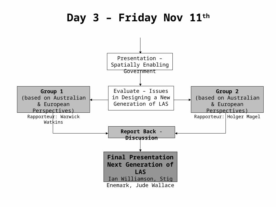
Report Back - Discussion
Group 1 (based on Australian & European Perspectives)
Rapporteur: Warwick Watkins
Evaluate – Issues in Designing a New
Generation of LAS
Day 3 – Friday Nov 11th
Presentation – Spatially Enabling Government
Final PresentationNext Generation of LAS
Ian Williamson, Stig Enemark, Jude Wallace
Group 2(based on Australian & European Perspectives)Rapporteur: Holger Magel

Key Observations (1)
• Land administration does not deliver sustainable development, however SD cannot be achieved without effective land administration
• European trend to legislate spatial enablement and codify self regulation
• Public private partnerships are increasing • Spatial cadastre is fundamental and accepted
by government and society • Land parcel is still central-
coordinated/spatially referenced
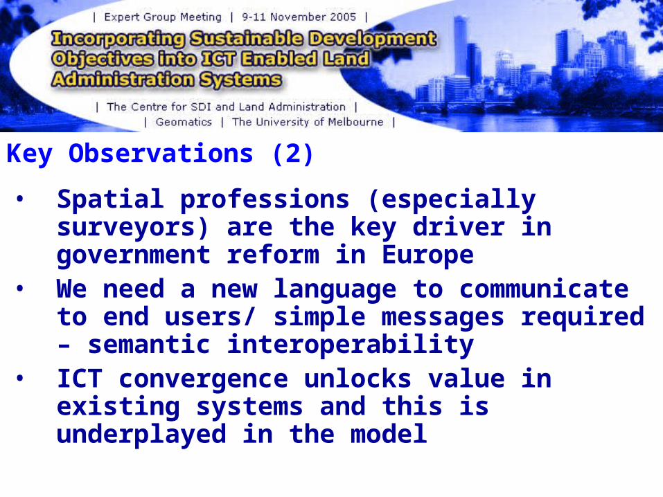
Key Observations (2)
• Spatial professions (especially surveyors) are the key driver in government reform in Europe
• We need a new language to communicate to end users/ simple messages required – semantic interoperability
• ICT convergence unlocks value in existing systems and this is underplayed in the model

Key Observations (3)
• Process is important – not entities• Without the cadastre and land registry,
land use planning, land tax and legal security in property, in support of sustainable development, is not possible
• Good governance in a complex world now requires integrated data approach
• Land administration needs information on both built and natural environment
• Must be a spatial dimension to LAS

Key Observations (4)
• Title is fundamental and is still undervalued• Institutional issues are still the primary
problem• End-User orientated approach is required
rather than technology focus• Environmental Issues: policy response in
Europe has been very different to Australia• Unbundling rights in AUS/Unheard of in Europe• Country Context is important- Education,
Institutional arrangements
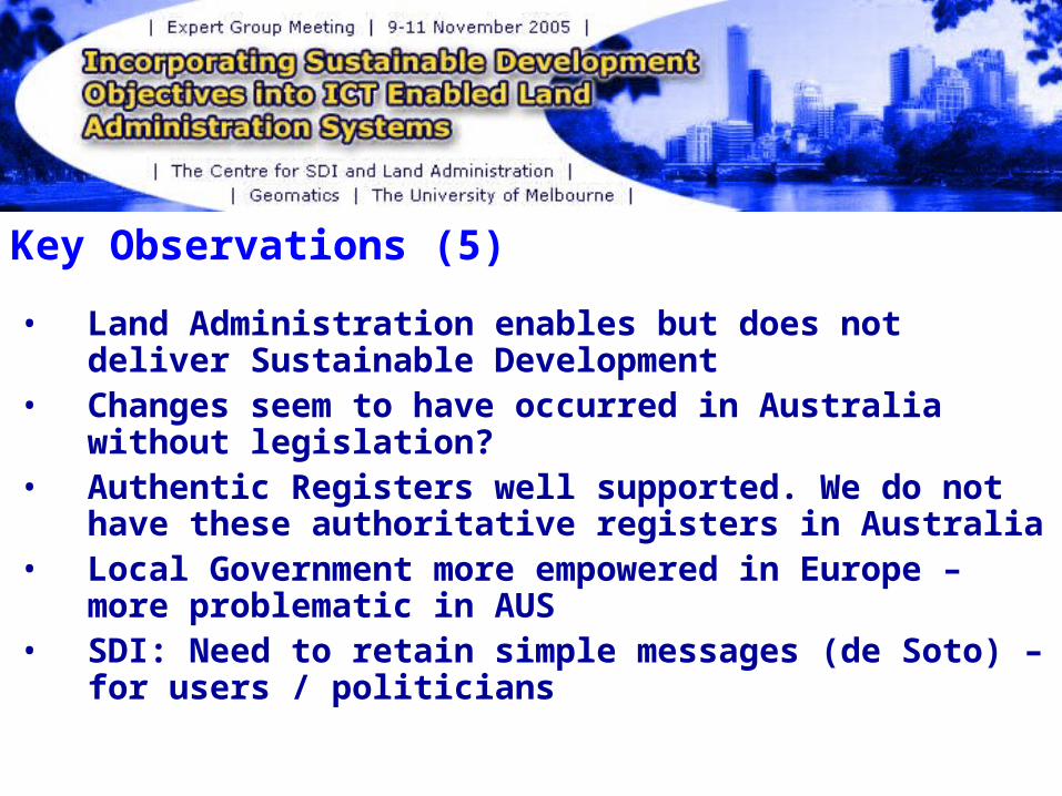
Key Observations (5)
• Land Administration enables but does not deliver Sustainable Development
• Changes seem to have occurred in Australia without legislation?
• Authentic Registers well supported. We do not have these authoritative registers in Australia
• Local Government more empowered in Europe – more problematic in AUS
• SDI: Need to retain simple messages (de Soto) – for users / politicians

The Paradigm
1. What is the vision for an ICT enabled LAS to support sustainable development?
2. Is a common understanding possible?

The Paradigm (1)• Land use planning, land development and land taxation
are confusing the model. The key is a unique, integrated and coordinated cadastre and land registry. This must be spatially enabled and support interoperability. Most land related activities rely on this (ie. Planning, valuation, land development)
• The model is a land management model, not a land administration model?
• Indicators/science not included in the model nor are reporting and evaluation mechanisms
• Revise the model to reflect service provision to citizens

The Paradigm (2)• In Australia:
– Unbundling has resulted in disparate management of ‘new property’ i.e. managing outside the LAS which are not TAXED
– Politics has had a large impact in rural Australia- different to Europe– We’ve yet to unlock value of the ‘parcel’ and existing land
administration systems• How do you promote this model to end-users, key stakeholders
(e.g. Utilities) AND politicians– Fundamentally there appears nothing wrong with Australian LAS
• Conceptually attractive model (efficiencies etc.), but, is it visionary enough?
• Link between LAS functions and sustainable development is not unique – other contributors
• Where are the people in this model?• Is the parcel approach limited? Geo-coding and addressing
offers far more opportunities
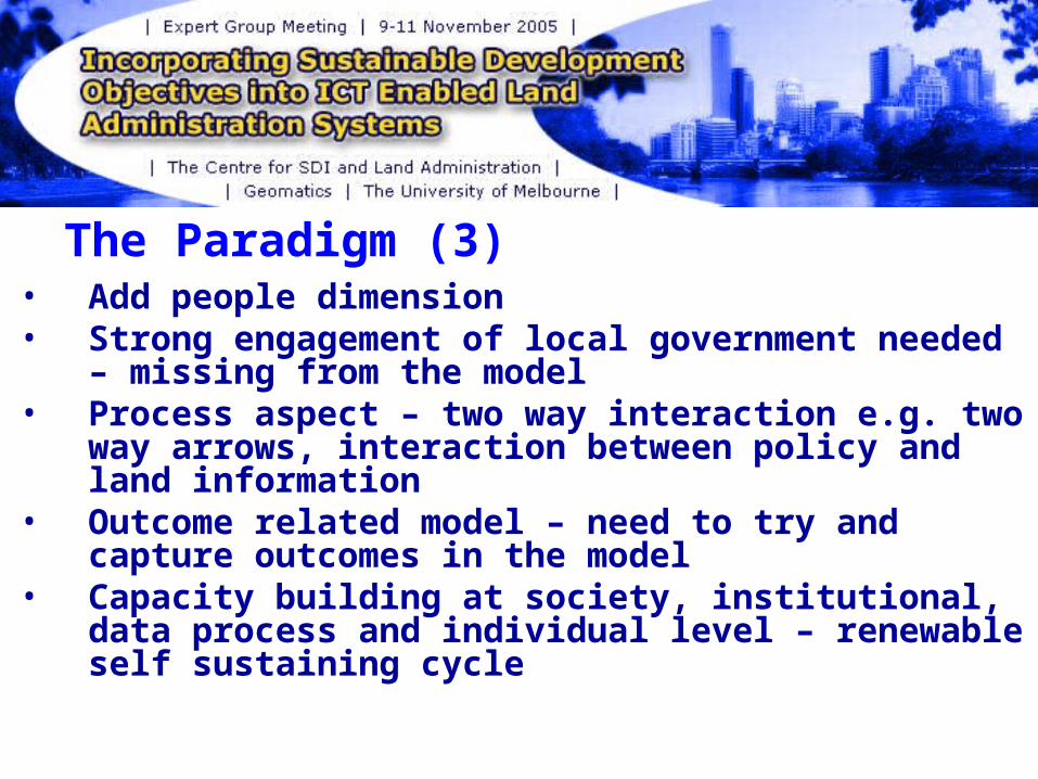
The Paradigm (3)• Add people dimension • Strong engagement of local government
needed – missing from the model• Process aspect – two way interaction e.g. two
way arrows, interaction between policy and land information
• Outcome related model – need to try and capture outcomes in the model
• Capacity building at society, institutional, data process and individual level – renewable self sustaining cycle
The Paradigm (4)• Need to take into account culture and value
systems• What sort of society, quality of life, personally
and as a community, do we want and hence what are the systems/infrastructure needed to deliver this ie. Creation and distribution of wealth, identification and protection of assets, protection and enhancement of the environment. All of this requires core information (including land) to underpin decision making and the outcomes
• Model encompasses core elements. Different jurisdictions have different focus.

Key Drivers (1)1. Environment Sustainability2. Business Efficiency3. Informed Decision Making4. Technology5. Security/ Anti-terrorism?6. Community Expectations7. Risk Management8. European Drivers:
- Environment was the key political driver for INSPIRE- Agricultural subsidies - Information technology- Fraud

Key Drivers (2)Remaining responsive to user needs at a whole of government level- Productivity as a result of IT application- Environmental needs – monitoring- Security - Revenue raising through tax- Image/pride- Meeting public expectation – servicing the
citizen

Key Components and Tools (1)
• Web Services• Standards/Shared Architectures• Government transparency- activities
NOT institutions• Spatially Enabled Interoperability (SDI)-
technical, semantic, legal• Cadastre (coordinated?) + other core
land related information

Key Components and Tools (2)• Authentic registers that are spatially enabled• A common data model in the cadastral domain,
especially in federated systems, is essential for interoperability
• Register of Interests/ Torrens System• Key component in building capacity are
education at universities, CPD and research activity
• Quality assurance framework

Key Components and Tools (3)• Core business of land administration
- Spatial dimension - RRR dimension- Tax and valuation- Land development
• Modern planning is adds value as a user of our information which should lead to sustainable development. Role of providing information to land users that want to make decisions about the use of land
• Land management will be more sustainably practised as a result of land information
• Land administration agencies are in the business of land information management for the plethora of user needs and land management outcomes

Future Challengers, Issues & Improvements (1)
1. Achieving a national system in a federated country
2. Achieving spatially enabled government3. How does the land registry system contribute to
SD? 4. Relationship between the land registry and
spatial cadastre5. Can international comparative monitoring be
established?6. Administration of restrictions and
responsibilities7. Is the land parcel still central to LA?8. The role of buildings in land administration

Future Challenges, Issues & Improvements (2)
• Engaging with the intended audience (citizens, politicians and NGOs)
• Consideration of the social dimension • Institutional silos - Overcoming silo approach• Professional culture clash• Maintenance costs• International
collaboration/monitoring/standardisation- Capacity Building of society, institutions and individuals
• 3D and 4D Cadastres

Future Challenges, Issues & Improvements (3)• Historical institutional frameworks are key barriers- ICT
can just ‘mask’ these problems• The language used in the spatial sector fails to sell
spatial technologies and information (simple / relevant)• Multi-jurisdictional problems- state vs. federal vs. local
vs. regional authorities- Should the model+ include these relationships / roles?
• Funding and governance arrangements need attention- These need to be understood to make the model relevant to a particular jurisdiction
• Recognise the components all interact in a social system• Value of property street address – this is what people
use, not Lot/Plan number• Difficulty of engaging stakeholders

Future Challenges, Issues & Improvements (4)• Engagement and interaction between all levels of
government• Shared vision, values and systems within a federated
system that facilitates interoperability- Need for unified data models, semantics and structures to
support this – progressed to a greater extent in Europe • Heading towards national systems• Marketing and presentation – recognising the client• Remember SDI is an infrastructure and enabling
platform for data integration, data sharing, data access – not an end in itself – it is all about data to data and data to people
• Bundling / unbundling of rights – does this service sustainable development – recognising that we still need to identify RRR of which some will have a value