Embed Size (px)
Citation preview
TS03G - GNSS CORS Networks Case Studies (Flash) Hasanuddin Z. Abidin, Heri Andreas, Irwan Gumilar, Farid H. Adiyanto, Wenny Rusmawar and Firmansyah On the Use of GPS CORS for Cadastral Survey in Indonesia FIG Working Week 2011 Bridging the Gap between Cultures Marrakech, Morocco, 18-22 May 2011
1/14
On the Use of GPS CORS for Cadastral Survey in Indonesia
Hasanuddin Z. ABIDIN, Heri ANDREAS, Irwan GUMILAR, Farid H. ADIYANTO, Wenny RUSMAWAR, Firmansyah, Indonesia
Key words: GPS, Terrestrial, Positioning, CORS, Indonesia, Cadastral SUMMARY The potential use of GPS CORS for cadastral surveys in Indonesia is very promising, especially for establishment of the cadastral control network and determination of parcel boundary coordinates. Up to 2010, from about 87 million land parcels in Indonesia, only about 46% has been registered.
In order to speed up the land administration process in Indonesia, since 1994 the National Land Agency of Indonesia (BPN) has started using GPS surveys for establishing the cadastral control networks of Indonesia. These cadastral networks are the considered as the 2nd and 3rd order national geodetic networks, and are connected to the 0th and 1st national geodetic networks. Since 2009, BPN has also been establishing GPS CORS, consisting of Class-A and Class-B type stations. Three stations around the capital city of Jakarta, i.e. Tangerang, Bekasi and Bogor, have been established and tested. Up to 2010, 40 GPS CORS stations have been established in Java and Bali islands.
The current status of use of the GPS survey and GPS CORS system for cadastral surveys in Indonesia will be presented in this paper. Challenges and limitations for sustainable operation of GPS CORS for cadastral survey in Indonesia will also be discussed.

TS03G - GNSS CORS Networks Case Studies (Flash) Hasanuddin Z. Abidin, Heri Andreas, Irwan Gumilar, Farid H. Adiyanto, Wenny Rusmawar and Firmansyah On the Use of GPS CORS for Cadastral Survey in Indonesia FIG Working Week 2011 Bridging the Gap between Cultures Marrakech, Morocco, 18-22 May 2011
2/14
On the Use of GPS CORS for Cadastral Survey in Indonesia
Hasanuddin Z. ABIDIN, Heri ANDREAS, Irwan GUMILAR, Farid H. ADIYANTO, Wenny RUSMAWAR, Indonesia
1. INTRODUCTION GPS is started to be used in Indonesia at the end of 1980s especially for surveying and mapping related purposes. Since 1992, the Indonesian National Coordinating Agency for Surveys and Mapping (Bakosurtanal) has also systematically conducted precise GPS surveys for refining and densifying the national geodetic control network of Indonesia [Subarya, 2004]. In this case, Bakosurtanal is responsible for establishing the 0th and 1st order national geodetic network. At present, these networks consisted of more than 950 GPS stations all over Indonesia, defined in the ITRF2005 reference frame. Since 1994, the National Land Agency (BPN) has also started using GPS surveys for establishing the cadastral control networks of Indonesia [Abidin et al., 1998]. These cadastral networks are the considered as the 2nd and 3rd order national geodetic networks, and are connected to the 0th and 1st geodetic networks maintained by Bakosurtanal.
The GPS CORS (Continuously Operating Reference Stations) in Indonesia were firstly operated by Bakosurtanal since 1996, consisting of three stations in Cibinong,West Java (BAKO station), in Medan, North Sumatra (SAMP station), and Parepare, South Sulawesi (PARE station) [Matindas and Subarya, 2009]. Afterward, Bakosurtanal expanded this GPS CORS network, and by April 2011 the network has consisted of 99 stations. In order to speed up the land administration process in Indonesia, BPN has also established GPS CORS, consisting of Class-A and Class-B type stations [Adiyanto et al., 2009]. Three stations around the capital city of Jakarta, i.e. Tangerang, Bekasi and Bogor, have been established and tested. In 2010, other 33 CORS stations are being established in Java and Bali and other strategic areas outside Java and Bali.
The current testing results of GPS CORS for cadastral surveys will be presented in this paper, especially those related to land parcel boundary determination and reconstruction. The GPS CORS derived coordinates of parcel boundary are analyzed and compared with the corresponding coordinates derived from GPS rapid static survey, GPS RTK system and terrestrial survey using Total Station. The accuracy analysis will be done with respect to various observation time periods, baseline lengths, and parcel surrounding conditions. Possible limiting factors for sustainable operation of GPS CORS for cadastral survey in Indonesia will also be discussed.
2. THE GPS CORS SYSTEMS IN INDONESIA In principle, the national GPS CORS network of Indonesia, is officially the one that is established by Bakosurtanal [Subarya, 2004; Matindas and Subarya, 2009; Abidin et al., 2010]. This network is usually termed as the Indonesian Permanent GPS Station Network (IPGSN). The primary purpose of the IPGSN is to maintain an accurate and precise geodetic reference frame over Indonesian region, and also to support a wide range of scientific and
TS03G - GNSS CORS Networks Case Studies (Flash) Hasanuddin Z. Abidin, Heri Andreas, Irwan Gumilar, Farid H. Adiyanto, Wenny Rusmawar and Firmansyah On the Use of GPS CORS for Cadastral Survey in Indonesia FIG Working Week 2011 Bridging the Gap between Cultures Marrakech, Morocco, 18-22 May 2011
3/14
practical applications such as geodynamics and deformation monitoring, meteorological and ionospheric studies, sea level monitoring, intelligent transportation systems, and real-time based surveying and mapping applications. The establishment of IPGSN network was initiated in 1996 which is started with three stations in Cibinong (West Java), Sampali Medan (North Sumatra) and Parepare (South Sulawesi). The network was afterward systematically strengthened with more stations, and after the Sumatra-Andaman earthquake and tsunami of 26 December 2004, the IPGSN network was rapidly developed. This rapid development is part of the development of the Indonesian Tsunami Early Warning System (InaTEWS). Afterward, Bakosurtanal expanded this GPS CORS network, and by April 2011 the network has consisted of 99 stations. All stations of IPGSN use the high precision L1/L2 geodetic type GPS receivers (i.e. Ashtech UZ-12, Leica GRX1200 family, Topcon GB-1000 and Net G3, and Septrentio PolarX2) with choke ring antennas and radomes, and most of the GPS receivers equipped with meteorological (temperature, pressure and humidity) sensors [Subarya et al., 2010]. Besides GPS receiver, the station also equipped with a radio or VPN-IP modem for data communication, sufficient batteries and solar panels to charge the batteries. GPS data is recorded at 1Hz rate and streamed in real time or near real time of 1 hour latency to the data processing center at Bakosurtanal office in Cibinong, West Java. Besides the national GPS CORS established and maintained by Bakosurtanal, other national agencies, such as the Indonesian Institute of Sciences (LIPI) and BPN have also started establishing their own GPS CORS network. LIPI, in collaboration with the California Institute of Technology (Caltech) and the Earth Observatory of Singapore (EOS), has established the SUGAR (Sumatera GPS Array) network, consisting of 32 continuous stations [Caltech, 2010; Natawidjaja, 2010]. All stations are equipped with the dual-frequency geodetic type receivers, with choke ring antennas and radomes; and record the data with 1 Hz data rate. The data collected by this CORS network has been used to study the deformation related characteristics of large earthquakes in the subduction zones of the Sumatra Island. In order to speed up the land administration process in Indonesia, BPN has also started to establish GPS CORS, consisting of Class-A and Class-B type stations. Three stations around the capital city of Jakarta, i.e. Tangerang, Bekasi and Bogor, have been established and tested [Adiyanto et al., 2009]. All of the BPN CORS stations will be equipped with dual-frequency geodetic-type GPS receivers. The Class-A type stations will be established on the ground and planned to have specification and performance comparable to the IPGSN stations maintained by Bakosurtanal. The Class-B type stations will usually installed on the building, preferably in the land office building in the corresponding areas. Up to the end of 2010, 40 GPS CORS stations have been established in Java and Bali.
Several universities, namely Institute of Technology Bandung (ITB) in Bandung, University of Gajah Mada (UGM) in Yogyakarta and Institute of Technology 10 November (ITS) in Surabaya have also established GPS CORS stations in their campuses [Sunantyo, 2009]. In this case, the Geodesy Research Division of ITB, in cooperation with GSI Japan, ERI University of Tokyo, and Bakosurtanal, has established 5 GPS CORS stations in West Java region. The main aim of this CORS network is to study the inter-seismic deformation of active faults in West Java, e.g. Cimandiri, Lembang and Baribis faults [Abidin et al, 2009].
TS03G - GNSS CORS Networks Case Studies (Flash) Hasanuddin Z. Abidin, Heri Andreas, Irwan Gumilar, Farid H. Adiyanto, Wenny Rusmawar and Firmansyah On the Use of GPS CORS for Cadastral Survey in Indonesia FIG Working Week 2011 Bridging the Gap between Cultures Marrakech, Morocco, 18-22 May 2011
4/14
3. APPLICATIONS OF GPS FOR CADASTRAL SURVEYING IN INDONESIA Up to present, GPS for cadastral surveying in Indonesia is mainly used for : (1) establishment of the cadastral control network, (2) determination of parcel boundary coordinates, and (3) reconstruction of parcel bounday points. Although GPS CORS are starting to be established, GPS is usually implemented in GPS survey static or in a single station GPS RTK modes. 3.1. Establishment of the cadastral control network
Since 1994, GPS static survey method has been used in establishment of the National Cadastral Reference Network (NCRN) [Abidin et al., 1998]. This network is established and maintained by the National Land Agency of Indonesia (BPN), and aimed to serve all cadastral surveying and mapping activities in Indonesia. The use of GPS was introduced for several reasons, namely: (1) existing national geodetic reference networks have been establsihed using GPS survey method; (2) to speed up the realization of national cadastral reference network, (3) to speed up the systematic land registration process all over Indonesia, and (4) to speed up the realization of national land information system.
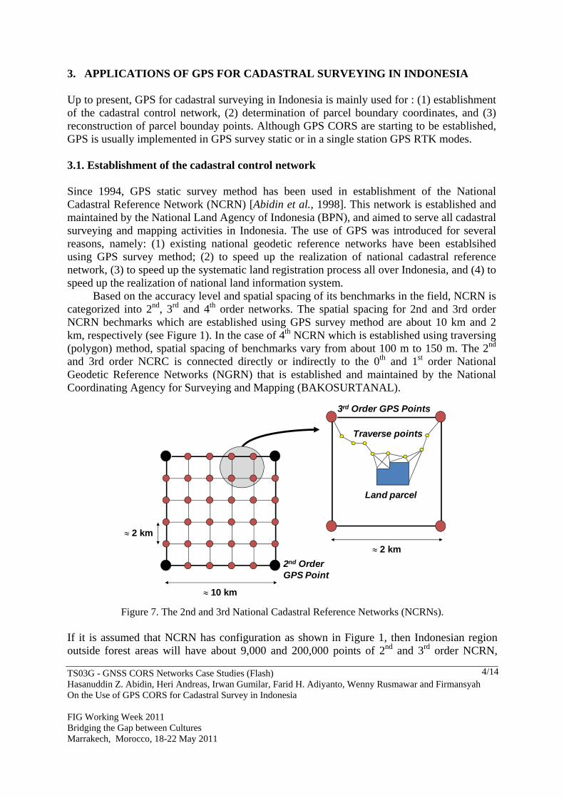
Based on the accuracy level and spatial spacing of its benchmarks in the field, NCRN is categorized into 2nd, 3rd and 4th order networks. The spatial spacing for 2nd and 3rd order NCRN bechmarks which are established using GPS survey method are about 10 km and 2 km, respectively (see Figure 1). In the case of 4th NCRN which is established using traversing (polygon) method, spatial spacing of benchmarks vary from about 100 m to 150 m. The 2nd and 3rd order NCRC is connected directly or indirectly to the 0th and 1st order National Geodetic Reference Networks (NGRN) that is established and maintained by the National Coordinating Agency for Surveying and Mapping (BAKOSURTANAL).
10 km
2 km
Land parcel
Traverse points
3rd Order GPS Points
2nd OrderGPS Point
2 km
Figure 7. The 2nd and 3rd National Cadastral Reference Networks (NCRNs). If it is assumed that NCRN has configuration as shown in Figure 1, then Indonesian region outside forest areas will have about 9,000 and 200,000 points of 2nd and 3rd order NCRN,

TS03G - GNSS CORS Networks Case Studies (Flash) Hasanuddin Z. Abidin, Heri Andreas, Irwan Gumilar, Farid H. Adiyanto, Wenny Rusmawar and Firmansyah On the Use of GPS CORS for Cadastral Survey in Indonesia FIG Working Week 2011 Bridging the Gap between Cultures Marrakech, Morocco, 18-22 May 2011
5/14
respectively. Up to 2010, the realization of these 2nd and 3rd order NCRN are about 70% (6,699 points) and 7% (14,085 points), respectively. Realization of NCRN in the field however, can not always follow the ideal rectangular shape as shown in Figure 1. The network shape is governed mainly by topography, land cover and land use in the survey area. Examples of realized NCRNs are shown in Figure 2.
3rd Order NCRN(Sleman region, Central Java)
Panjang Baseline10 km 2 km2rd Order NCRN
(East Java)
2nd Order NCRN
1st Order NGRN
0th Order NGRN
Figure 2. Examples of 2nd and 3rd order NCRN realization. In general, the typical relative accuracy of coordinates of the NCRN benchmarks are in the order of several cm, as shown by the example given in Figure 3.
0
1
2
3
4
5
6
0 2 4 6 8 10 12 14 16Baseline length (km)
Semimajoraxis (cm)
Semimajor axisof 95% error ellipse
Baseline length (km)
1
2
3
4
5
6
7
0.50 1.0 1.5 2.0 2.5 3.0 3.5
Semimajor axisof 95% error ellipse
Semimajoraxis (cm)
Semimajor
Figure 3. Typical relative accuracy of 2nd and 3rd order NCRNs. These results are associated with the networks shown in Figure 2.

TS03G - GNSS CORS Networks Case Studies (Flash) Hasanuddin Z. Abidin, Heri Andreas, Irwan Gumilar, Farid H. Adiyanto, Wenny Rusmawar and Firmansyah On the Use of GPS CORS for Cadastral Survey in Indonesia FIG Working Week 2011 Bridging the Gap between Cultures Marrakech, Morocco, 18-22 May 2011
6/14
In order to speed up the land administration process in Indonesia, since 2009 BPN has also started to establish GPS CORS, consisting of Class-A and Class-B type stations (see Figure 4). Three stations around the capital city of Jakarta, i.e. Tangerang, Bekasi and Bogor, have been established and tested [Adiyanto et al., 2009]. All of the BPN CORS stations are equipped with dual-frequency geodetic-type GPS receivers. The Class-A type stations will be established on the ground and planned to have specification and performance comparable to the IPGSN stations maintained by Bakosurtanal. The Class-B type stations will usually installed on the building, preferably in the land office building in the corresponding areas, as shown in Figure 5.
Figure 4. Planned location and distribution of BPN GPS CORS station in Java [Adiyanto and Wibisono, 2009]. Class-A and Class-B stations are denoted with red and yellow circles respectively.
Figure 5. The first three BPN CORS stations; from Adiyanto et al. (2009).
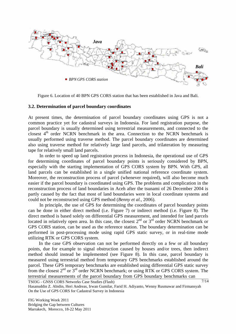
Up to the end of 2010, 40 GPS CORS stations have been established in Java and Bali, and their locations are shown in Figure 6. The class (A or B) of this 40 station will be decided after considering their operational performance and data quality. In order to enhance the development of BPN GPS CORS system, the following program will be executed by BPN in 2011, namely : (1) Establishment of other 30 CORS stations in Java, (2) Establishment of 23 CORS stations outside Java, i.e. Sumatera, Nusa Tenggara, Kalimantan and Sulawesi; (3) Development of BPN GPS CORS website; (4) Development of web-based CORS data processing system, (5) Determination of new national reference system for cadastral applications (in cooperation with Bakosutanal), and (6) Cooperation with CORS users.
TS03G - GNSS CORS Networks Case Studies (Flash) Hasanuddin Z. Abidin, Heri Andreas, Irwan Gumilar, Farid H. Adiyanto, Wenny Rusmawar and Firmansyah On the Use of GPS CORS for Cadastral Survey in Indonesia FIG Working Week 2011 Bridging the Gap between Cultures Marrakech, Morocco, 18-22 May 2011
7/14
Bali
Java
BPN GPS CORS station
Figure 6. Location of 40 BPN GPS CORS station that has been established in Java and Bali. 3.2. Determination of parcel boundary coordinates At present times, the determination of parcel boundary coordinates using GPS is not a common practice yet for cadastral surveys in Indonesia. For land registration purpose, the parcel boundary is usually determined using terrestrial measurements, and connected to the closest 4th order NCRN benchmark in the area. Connection to the NCRN benchmark is usually performed using traverse method. The parcel boundary coordinates are determined also using traverse method for relatively large land parcels, and trilateration by measuring tape for relatively small land parcels.
In order to speed up land registration process in Indonesia, the operational use of GPS for determining coordinates of parcel boundary points is seriously considered by BPN, especially with the starting implementation of GPS CORS system by BPN. With GPS, all land parcels can be established in a single unified national reference coordinate system. Moreover, the reconstruction process of parcel (whenever required), will also become much easier if the parcel boundary is coordinated using GPS. The problems and complication in the reconstruction process of land boundaries in Aceh after the tsunami of 26 December 2004 is partly caused by the fact that most of land boundaries were in local coordinate systems and could not be reconstructed using GPS method (Benny et al., 2006).
In principle, the use of GPS for determining the coordinates of parcel boundary points can be done in either direct method (i.e. Figure 7) or indirect method (i.e. Figure 8). The direct method is based solely on differential GPS measurement, and intended for land parcels located in relatively open area. In this case, the closest 2nd or 3rd order NCRN benchmark or GPS CORS station, can be used as the reference station. The boundary determination can be performed in post-processing mode using rapid GPS static survey, or in real-time mode utilizing RTK or GPS CORS system.
In the case GPS observation can not be performed directly on a few or all boundary points, due for example to signal obstruction caused by houses and/or trees, then indirect method should instead be implemented (see Figure 8). In this case, parcel boundary is measured using terrestrial method from temporary GPS benchmarks established around the parcel. These GPS temporary benchmarks are established using differential GPS static survey from the closest 2nd or 3rd order NCRN benchmark; or using RTK or GPS CORS system. The terrestrial measurements of the parcel boundary from GPS boundary benchmarks can

TS03G - GNSS CORS Networks Case Studies (Flash) Hasanuddin Z. Abidin, Heri Andreas, Irwan Gumilar, Farid H. Adiyanto, Wenny Rusmawar and Firmansyah On the Use of GPS CORS for Cadastral Survey in Indonesia FIG Working Week 2011 Bridging the Gap between Cultures Marrakech, Morocco, 18-22 May 2011
8/14
be performed using ETS (Electronic Total Station) or measuring tapes. Considering the typical topography, land use and land coverage in rural and urban areas of Indonesia, the indirect method will be more frequently used for cadastral surveys in Indonesia.
GPS satellites
GPSReference 4
GPSRover
GPS observation route
Parcel
3rdOrder of NCRN(can be replaced byGPS CORS Station)
Figure 7. GPS-based determination of parcel boundary coordinates (direct method)
Terrestrialmeasurements
GPSSatellites
GPSReference
3rdOrder of NCRN(can be replaced byGPS CORS Station)
GPS temporarybenchmark ‐ 1
Parcel
GPS temporarybenchmark ‐ 2
Figure 8. GPS and terrestrial based determination of parcel boundary coordinates (indirect method)
Results from the test case of determination of parcel boundary coordinates shown in Table 1 indicated the superiority of direct method over indirect method in term of number of surveyed parcels per day. The test cases are conducted in urban and rural areas around Jakarta

TS03G - GNSS CORS Networks Case Studies (Flash) Hasanuddin Z. Abidin, Heri Andreas, Irwan Gumilar, Farid H. Adiyanto, Wenny Rusmawar and Firmansyah On the Use of GPS CORS for Cadastral Survey in Indonesia FIG Working Week 2011 Bridging the Gap between Cultures Marrakech, Morocco, 18-22 May 2011
9/14
and Bali in November 2010, involving 40 land parcels with areas less than 10,000 m2. The implemented CORS-RTK method in this test case is basically a real-time kinematic GPS differential positioning. In the case of rapid GPS static survey, each boundary point is occupied at least about 15 minutes for achieving relative accuracy of about 5 cm or higher.
Tabel 1. Results of determination of parcel boundary coordinates,
from test cases in Jakarta and Bali involving 40 land parcels with areas less than 10,000 m2.
Method
Urban Areas (distance to NCRN benchmark < 5 km)
Rural Areas (distance to NCRN
benchmark < 13 km) Parcels per day
Relative Accuracy
Parcels per day
Relative Accuracy
CORS-RTK 30 1-5 cm 20 10-20 cm GPS rapid static 5 1-5 cm 5 1-5 cm
GPS rapid static + ETS measurement
6 1-5 cm 6 1-5 cm
3.3. Reconstruction of parcel bounday points As in the case of determination of parcel boundary points, the reconstruction of parcel boundary points using GPS, can be performed using direct method (i.e. Figure 9) or indirect method (i.e. Figure 10). The direct method should be used for land parcels in relatively open area with no significant obstruction to GPS signal observation; while the indirect method should be used for land parcels which have significant signal obstruction surroundings.
GPSSatellites
GPSReference
GPSRover
Parcel
Target N
Data Link
Display
Observer
3rdOrder of NCRN(can be replaced byGPS CORS Station)
Figure 9. GPS based reconstruction of parcel bounday points (direct method).

TS03G - GNSS CORS Networks Case Studies (Flash) Hasanuddin Z. Abidin, Heri Andreas, Irwan Gumilar, Farid H. Adiyanto, Wenny Rusmawar and Firmansyah On the Use of GPS CORS for Cadastral Survey in Indonesia FIG Working Week 2011 Bridging the Gap between Cultures Marrakech, Morocco, 18-22 May 2011
10/14
In reality, these GPS based reconstruction methods have been rarely used for cadastral surveys in Indonesia. However, these methods has been effectively used during the rehabilitation and reconstruction process after the 26 December of 2004 tsunami in Aceh [Abidin et al., 2005; Benny et al., 2006]; and since then these methods have gained more respect and popularity from surveying community in Indonesia.
Parcel
GPS Baseline Observation
3rdOrder of NCRN(can be replaced byGPS CORS Station)
GPS temporaryBenchmark#1
GPS temporaryBenchmark#2
Terrestrialmeasurements
Figure 10. GPS and terrestrial based reconstruction of parcel bounday points (indirect method).
4. CHALLENGES AND LIMITATIONS In establishing, operating and maintaining the good and reliable GPS CORS network of BPN that can serve cadastral surveys all over Indonesia, there are several challenges and limitations that have to be properly taken into consideration. These factors have both structural and cultural natures, and can be summarized as in the following points. 1. The reliability of the BPN GPS CORS will strongly depend on good and reliable
communication links between the continuous GPS stations and its data processing centre. All GPS CORS stations will be most probably located at the district land offices all over Indonesia. Considering the vast area being cover, the archipelagic nature of Indonesia, and relatively high spatial divide in the communication infrastructure inside the Indonesian region, the communication link aspects of the CORS system should be planned and established in an effective and efficient manner.
2. In order to have good, reliable and continuous mode of operation, all remote continuous
GPS stations will also require proper and continuous maintenance and caring. Each station will therefore need proper resources all year long, e.g. electrical power supply, related hardware and software resources, and human resources for checking and taking care the station site and equipments. The difficulty in operating and maintaining the BPN GPS CORS station in Indonesia will vary and usually getting more difficult when its location getting farther away from Java island and/or from large urban areas. The financial support for the daily operation and maintenance of GPS CORS stations therefore should always be considered, preferably in the long term basis.

TS03G - GNSS CORS Networks Case Studies (Flash) Hasanuddin Z. Abidin, Heri Andreas, Irwan Gumilar, Farid H. Adiyanto, Wenny Rusmawar and Firmansyah On the Use of GPS CORS for Cadastral Survey in Indonesia FIG Working Week 2011 Bridging the Gap between Cultures Marrakech, Morocco, 18-22 May 2011
11/14
3. Maintenance and operation of the relatively large scale BPN GPS CORS networks in Indonesia, will require also conducive and professional working culture, and also good support from dedicated and professional human resources at BPN and all district land offices. This human capital, is not needed just to operate and maintain the whole system, but also to process the collected data and analyze the obtain results for various applications and interests. At present times, the working culture in the government offices are not always compatible and suitable with the working culture needed for maintaining and operating the good and reliable GPS CORS networks. The number of qualified and dedicated persons for maintaining and operating GPS CORS should also be increased and provided with proper reward and remuneration. In this case, outsourcing part of the operational and maintenance activities of BPN GPS CORS network to the private company may also be considered.
4. Since the large scale BPN GPS CORS network covering Indonesian region will require
substantial amount of qualified human capital, the related human resource development program should also be systematically planned by BPN and the land offices. In terms of high learning institutions, at present times in Indonesia there are four state universities (ITB Bandung, UGM Yogyakarta, ITS Surabaya, and Undip Semarang) and three private universities (Itenas Bandung, ITN Malang, University of Pakuan Bogor) that have study programs on surveying, geodesy and/or geomatics engineering. In the context of GPS CORS related capacity building in related institution, those high learning institutions, besides supplying their graduates can also offer various Continuing Education Programs (CEP) for enhancing the competency of human resources belonging to various agencies related to the GPS CORS programs.
5. Since the development of good and reliable national BPN GPS CORS network will absorb
a lot of money and efforts, the use of the system is preferably not just only for supporting cadastral surveys and other land administration related activities. Instead it should also support other national needs and interests in land and coastal positioning, surveying and mapping activities. Since each application usually will have their own specification on data requirement and management, then the BPN GPS CORS system should be adaptively designed and operated to fully support those various applications.
5. CLOSING REMARKS
Up to 2010, from about 87 million land parcels in Indonesia, only about 46% has been registered. In order to speed up this land registration process, BPN should established as soon as possible the GPS CORS system that can fully support the cadastral surveys all over Indonesian region. The synergism of this BPN GPS CORS system with the Bakosurtanal IPGSN system (Abidin et al., 2010) should also be realized, both in conceptual and operational domains. The existence of good and reliable BPN GPS CORS network covering the Indonesian region will not just usefull for cadastral surveys, but also other land positioning, surveying and mapping activities. The advancements of BPN GPS CORS networks in Indonesia should also be supported
TS03G - GNSS CORS Networks Case Studies (Flash) Hasanuddin Z. Abidin, Heri Andreas, Irwan Gumilar, Farid H. Adiyanto, Wenny Rusmawar and Firmansyah On the Use of GPS CORS for Cadastral Survey in Indonesia FIG Working Week 2011 Bridging the Gap between Cultures Marrakech, Morocco, 18-22 May 2011
12/14
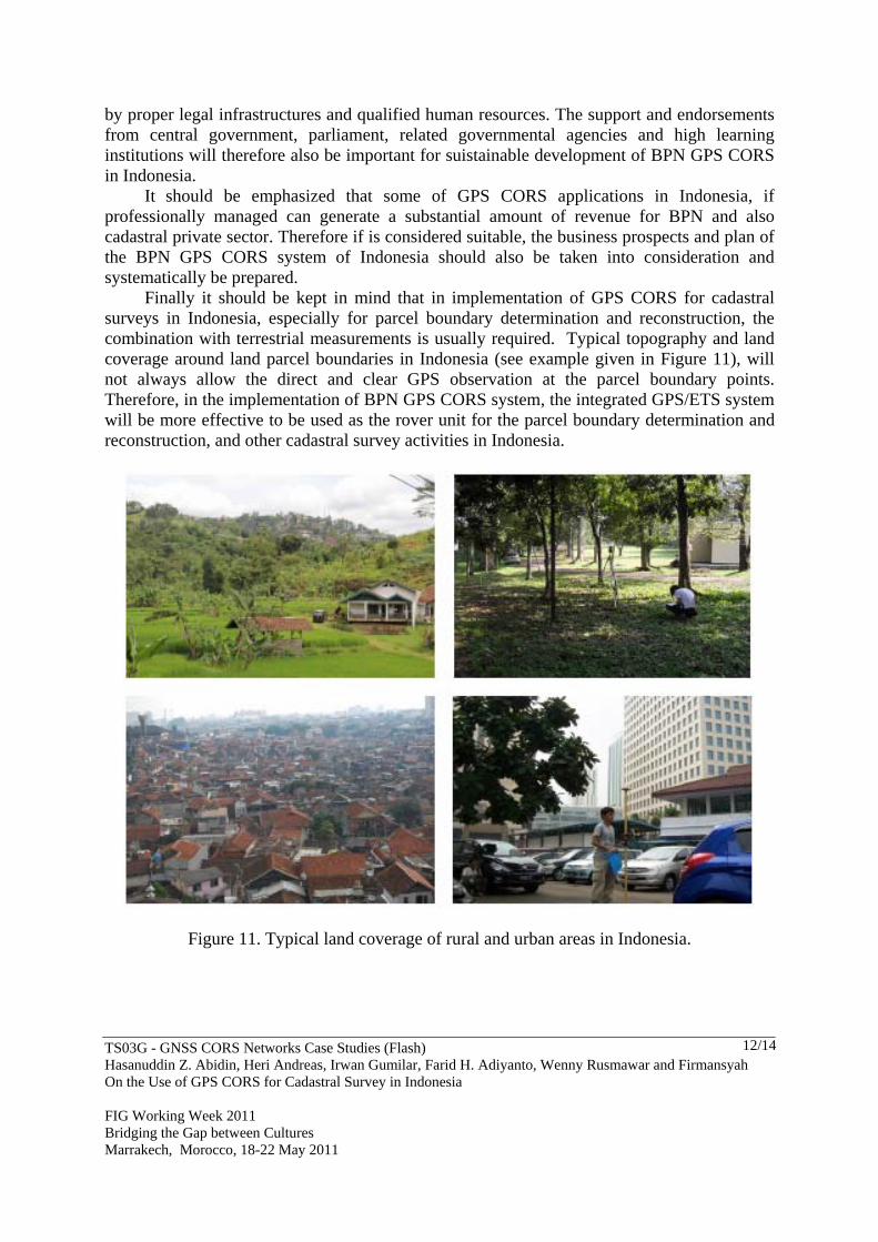
by proper legal infrastructures and qualified human resources. The support and endorsements from central government, parliament, related governmental agencies and high learning institutions will therefore also be important for suistainable development of BPN GPS CORS in Indonesia. It should be emphasized that some of GPS CORS applications in Indonesia, if professionally managed can generate a substantial amount of revenue for BPN and also cadastral private sector. Therefore if is considered suitable, the business prospects and plan of the BPN GPS CORS system of Indonesia should also be taken into consideration and systematically be prepared. Finally it should be kept in mind that in implementation of GPS CORS for cadastral surveys in Indonesia, especially for parcel boundary determination and reconstruction, the combination with terrestrial measurements is usually required. Typical topography and land coverage around land parcel boundaries in Indonesia (see example given in Figure 11), will not always allow the direct and clear GPS observation at the parcel boundary points. Therefore, in the implementation of BPN GPS CORS system, the integrated GPS/ETS system will be more effective to be used as the rover unit for the parcel boundary determination and reconstruction, and other cadastral survey activities in Indonesia.
Figure 11. Typical land coverage of rural and urban areas in Indonesia.

TS03G - GNSS CORS Networks Case Studies (Flash) Hasanuddin Z. Abidin, Heri Andreas, Irwan Gumilar, Farid H. Adiyanto, Wenny Rusmawar and Firmansyah On the Use of GPS CORS for Cadastral Survey in Indonesia FIG Working Week 2011 Bridging the Gap between Cultures Marrakech, Morocco, 18-22 May 2011
13/14
REFERENCES Abidin, H. Z., A. Jones, K. Sarah, and R. Anshari (1998). "GPS Groundwork : Building Indonesia’s
Cadastral Network." GPS World, September, Volume 9, Number 9, pp. 56 - 62. Abidin, H.Z., I. Meilano, E. Heryani, A. Budiwibowo, S. Bachri, E. Rommel, B.A. Yanto (2005).
“Rekonstruksi Batas Persil Tanah di Aceh Pasca Tsunami”. Jurnal Infrastruktur dan Lingkungan Binaan. ISSN 1858-1390, Vol. I, No. 2, December, pp. 1-10.
Abidin, H.Z., H.Andreas, T. Kato, T. Ito, I. Meilano, F. Kimata, D.H. Natawidjaya and H. Harjono
(2009). “Crustal Deformation Studies in Java (Indonesia) Using GPS. Journal of Earthquake and Tsunami, World Scientific Publishing Company, Vol. 3, No. 2 (2009) 77–88.
Abidin, H.Z., C. Subarya, B. Muslim, F.H. Adiyanto, I. Meilano, H. Andreas, and I. Gumilar (2010).
“The Applications of GPS CORS in Indonesia: Status, Prospect and Limitation”, Proceedings of the FIG Congress 2010, TS 4C - GNSS CORS Networks - Infrastructure, Analysis and Applications II, Sydney, Australia, 11-16 April 2010.
Adiyanto, F.H., G. Wibisono, and B. Ardiantoro (2009). ”Roadmap of developing GNSS CORS
networks for cadastral surveying in Indonesia”, Proceedings of the 10th South East Asian Survey Congress, 4 - 7 August 2009, BICC, Nusadua, Bali, Indonesia, pp. 226-234.
Benny, H.Z. Abidin, Tony S. Haroen, Erna Heryani (2006). “Post-Tsunami Land Parcel
Reconstruction in Aceh: Aspects, Status and Problems”, Proceedings of the XXIII FIG Congress (in CD Rom), TS 45 Session – World Bank Co-operation - Disaster Management and Land Administration, Munich, Germany, October 8-13, 2006.
Caltech (2010). Website of the Sumatran Plate Boundary Project, California Institute of Technology
(Caltech). Site address: http://www.tectonics.caltech.edu/sumatra/index.html, accessed 4 January 2010.
Matindas, R.W. and C. Subarya (2009). ”Present Status of the Indonesian Permanent GPS Station
Network and Development”, Paper presented at the 7th FIG Regional Conference 2009, Hanoi, Vietnam, 19 - 22 October.
Natawidjaja, D.H. (2010). Personal Communication. Researcher at the Geotechnology Research and
Development Center of LIPI, by e-mail ([email protected]), Wednesday, January 06. Subarya, C. (2004). ”The Maintenance of Indonesia Geodetic Control Network - In the Earth
Deforming Zones”, Paper of the 3rd FIG Regional Conference, Session TS8 – Reference Frame in Practice, Jakarta, Indonesia, October 3-7.
Subarya, C., H.Z. Abidin, W. Kuncoro and J. Efendi (2010). ”GPS Analysis Strategies to Minimize the
Error Contribution to Geodetic GPS Determination”, Paper to be presented at the FIG Congress 2010, Sydney, Australia, 11-16 April.
Sunantyo, A. (2009). ”GNSS CORS Infrastructure and Standard in Indonesia”, Paper presented at the
7th FIG Regional Conference 2009, Hanoi, Vietnam, 19 - 22 October.
TS03G - GNSS CORS Networks Case Studies (Flash) Hasanuddin Z. Abidin, Heri Andreas, Irwan Gumilar, Farid H. Adiyanto, Wenny Rusmawar and Firmansyah On the Use of GPS CORS for Cadastral Survey in Indonesia FIG Working Week 2011 Bridging the Gap between Cultures Marrakech, Morocco, 18-22 May 2011
14/14
BIOGRAPHICAL NOTES Prof. Dr. Hasanuddin Z. Abidin, is a Professor and Head of Geodesy Research Group, Faculty of Earth Science and Technology, Institute of Technology Bandung, Indonesia. He obtained his Insinyur degree from Dept. of Geodetic Engineering, ITB in 1985, and his MSc.Eng and PhD degrees from the Department of Geodesy and Geomatics Engineering (previously Dept. of Surveying Engineering), Univ. of New Brunswick, Canada, in 1989 and 1992 respectively. His academic background is related to the theory and applications of satellite geodesy; and his research works up to the present times includes the following areas, namely : ambiguity resolution of GPS signals; the use of GPS system for geodetic surveying, land surveying, cadastral surveying, and marine applications; use of GPS survey method for monitoring volcano deformation, land subsidence, landslide, and dam deformation; geodetics aspects of the international boundary; and integration of GPS and INSAR for deformation study. CONTACTS Prof. Dr. Hasanuddin Z. Abidin Geodesy Research Group Faculty of Earth Science and Technology Institute of Technology Bandung, Jl. Ganesa 10 Bandung INDONESIA Tel. + 62-22-2534286 Fax + 62-22-2500935 Email: [email protected] and [email protected] Web site: http://geodesy.gd.itb.ac.id/hzabidin