Embed Size (px)
Citation preview

Exhibit A May 4th 2009
On-Shore Bird and Bat Pre- and Post-Construction Monitoring Protocol for Commercial Wind Energy Facilities in Ohio
An Addendum to the Ohio Department of Natural Resource’s Voluntary
Cooperative Agreement
The following protocols are meant to establish a standardized framework in which pre- and post-construction surveying should be conducted at proposed commercial wind turbine facilities within the state of Ohio. The Ohio Department of Natural Resources (ODNR) will assess the level of surveying effort required within the project area boundary limits (henceforth referred to as the “site”), based upon the information provided from section 1.(a) of the Cooperative Agreement, the habitat characteristics within the site (determined through a site visit by ODNR Division of Wildlife biologists and GIS analysis), and its proximity to focal points of bird and bat activity. Additional surveys for species other than birds and bats may be requested based upon a review of the ODNR Division of Natural Areas and Preserves’ natural heritage database. These studies are meant to document the level and timing of species activity, diversity and abundance. Results of the studies outlined within this document will allow the ODNR Division of Wildlife to assess the potential impact that a proposed turbine facility may have either directly through mortalities or indirectly through avoidance behaviors, on Ohio’s wildlife resources. Post-construction mortality estimates will be used to validate or refute pre-construction predictions, and to determine if the use of mitigation measures is warranted in order to minimize impacts to wildlife. By having consistent study methodology among projects, over time a regional assessment may be formed for adjusting the methods or duration of the studies recommended. The type of surveying recommended will be at the discretion of the ODNR Division of Wildlife, and will be tailored to the specific site, but may fit generally into one of the categories listed below. These survey types are to be cumulative, meaning if the “moderate” level of surveying is required, the survey techniques described in the “minimum” level must also be conducted. While this document is intended to serves as a guide for wind developers as they plan projects and determine the level and type of wildlife monitoring that is likely to be recommended, the ODNR Division of Wildlife reserves the right to be flexible in the application of these surveys based on site-specific or project-specific conditions.
• Minimum These areas are large tracts of agricultural lands that do not come within 500 meters of a woodland ≥10 hectares, wetlands ≥3 hectares, or large water body (i.e., rivers, lakes or reservoirs).
• Moderate Primarily agricultural or grasslands, with patches of forests, wetlands, and/or other habitat.
Page 1 of 40

Exhibit A May 4th 2009
• Extensive These include those areas within proximity to migratory corridors, staging areas, Audubon Important Bird Areas (IBAs), or the Lake Erie shoreline (3-mile buffer) (Fig. 1).
In an effort to standardize information collected among projects, data should be recorded on forms provided for each of the various types of recommended surveys for all pre- and post-construction monitoring activities. Completed forms should be returned to the ODNR Division of Wildlife at the conclusion of surveying. Weather data should be recorded during all types of surveying (e.g. temperature, relative humidity, cloud cover, wind speed and direction). 1. Minimum Surveying Effort
1.1. Breeding birds
While breeding birds in the eastern United States have not been shown to be at high risk of mortality from turbines within their territories, it is important to identify what species may be impacted through habitat disturbance or avoidance. Therefore, point-counts should be conducted at all proposed turbine locations, with 2 points established for each turbine. The first set of points should be ~ 100-meters from the turbine or any adjacent proposed turbine locations. The second set of points will be between 125 to 300-meters (distance assigned by ODNR on a site by site basis) from any proposed turbines. The 100-meter point will be used to assess those species that may be directly affected by construction of the turbine; the second point will be used to assess indirect impacts such as avoidance. Effort should be made to place all points in nearby undisturbed habitat that will remain post-construction. Habitat for the point-counts should be similar to that of the turbine location. Because of increased detectability, points within grassland habitats may be placed at every other turbine. If turbine locations have not yet been determined, 2 point-count locations should be established for the maximum number of turbines proposed. These points should be randomly stratified across the site relative to the proportion of individual habitat types. Generally, active agricultural fields are not considered suitable nesting habitat for most species of birds; thus, surveys do not need to be conducted at any point that falls within these areas. Point-count locations (GIS coverage and/or GPS coordinates) should be provided to the ODNR Division of Wildlife. Three 10-minute point-count surveys should be conducted at each point: 1 in May, and 2 in June. Certain bird species do not frequently sing until later in the breeding season; given this reduced detectability, 1 additional point-count is required in July for sites with suitable habitat for the Henslow’s sparrow, dickcissel, and/or sedge wren. These additional point-counts should be conducted on sites that contain or are directly adjacent to >50 hectares of contiguous grassland (for all 3 species) or >1 hectare of wet meadow or freshwater marsh (for sedge wren only).
Page 2 of 40

Exhibit A May 4th 2009
All surveys should begin at approximately dawn and not extend past 10:00 a.m. EST. Surveys should be conducted by experienced personnel who are able to distinguish Ohio breeding bird species by sight and sound. All birds detected during surveys should be identified to species and their behavior, indications of breeding activity (refer to breeding bird atlas codes1), estimated distance, and direction (bearing) should be recorded. Birds flying overhead that do not land or originate within 200-meters of the center of the point should be listed as “fly over.” Observations should be recorded using appropriate alpha species codes2. Incidental observations of state and federal threatened or endangered species (Table 1) should be noted regardless of whether detected with the given survey time or while at a point-count location. Due to reduced detectability, surveys are not to be conducted on mornings of heavy wind (>5 meters/second), prolonged periods of rain (>20 minutes), or fog. To assess avoidance of the project area after construction, surveys should be conducted 1 year prior to and 1 year post-construction. For wind energy development projects proposed by Voluntary Agreement cooperators on sites deemed to pose minimum risk to wildlife resources only, breeding bird surveying can occur prior to construction and after submission of the associated permit application to the Ohio Power Siting Board (OPSB). Under these conditions, the ODNR Division of Wildlife will certify to the OPSB that these data are not required prior to evaluating the potential ecological impacts at the site of the proposed project. Submission of survey results to the ODNR Division of Wildlife must occur prior to construction, and post-construction monitoring, as noted above, is still required.
1.2. Raptor nest searching
One early season (1 February – 31 March) survey should be conducted on and within 1 mile of the proposed site. A 2-mile buffer should be used if the site is within 1 mile of large water bodies (lakes, rivers, or reservoirs) or wetlands >5 hectares as these areas have a higher potential for use by threatened or endangered species of raptors. The species and locations of nest sites should be marked on USGS 1:24,000 topographic quadrangles. 1.2.1. Raptor nest monitoring
Monitoring should be conducted to assess the daily movement patterns of any species of protected raptor whose nest is located within 2 miles of the proposed site. During the incubation and rearing stage the location of adult birds should be tracked for at least 4 hours twice per week until consistent activity patterns are established. Alternate monitoring strategies that assess the degree to which nesting raptors use the proposed turbine facility will be considered (contact ODNR Division of Wildlife). Information collected
1 http://www.ohiobirds.org/obba2/uploads/Handbook%20Body.pdf 2 http://www.pwrc.usgs.gov/bbL/manual/sname.htm
Page 3 of 40

Exhibit A May 4th 2009
will be used to document how frequently the birds enter the proposed turbine facility and whether particular turbines may pose a more substantial risk.
1.3. Bat acoustic monitoring
With the expansion of wind turbines into the eastern United States, incidences of bat mortalities have become increasingly more common. Initially, these issues were limited to forested sites within the Appalachian Mountains. Now, unfortunately, they have been documented on agricultural sites as well. As a result, bat activity levels should be assessed at all proposed wind turbine facilities. For sites deemed to pose minimum risk to wildlife resources only, bat acoustic monitoring can be waived for Voluntary Agreement cooperators if the permit application for the wind turbine facility is conditioned such that turbines will not operate at wind speeds ≤4 meters/second (as measured within the rotor swept area) from dusk to dawn, July 1 to October 31 annually. Under these conditions, post-construction acoustic data will not be required unless unacceptable mortality rates are detected. At least 1 full season (15 March – 15 November) of acoustic monitoring should be conducted. This can be accomplished by attaching AnaBat (either SD1 or those equipped with CF ZCAIMS) units to all meteorological towers, with 1 unit positioned at 5 meters of the ground, and 1 unit within or as close as possible to the rotor swept area. In an effort to standardize results among study sites, the AnaBat’s sensitivity should be adjusted to detect a calibration tone3 at 20 meters. AnaBat units must monitor from 0.5 hour before sunset until 0.5 hour after sunrise. A “pass” will be defined as any file with ≥2 echolocation pulses. When possible, detections should be identified to species or species group (e.g., big brown/silver-haired) within AnaLook. Copies of original and identified detections should be provided to the ODNR Division of Wildlife. In an effort to assess both potential attractant issues, and to correlate the number of detections with bat mortalities, acoustic monitoring should continue through the conclusion of post-construction monitoring.
2. Moderate surveying effort
2.1. Passerine migration
Numerous incidences exist of nocturnally migrating songbirds colliding with tall structures such as lighthouses, cell phone towers, and tall buildings. It is unclear what the cumulative impact of potentially 100s of turbines on the landscape will be to migrating birds. In an effort to gauge the amount of use a particular site receives during bird migration, point-counts should be conducted in the spring and fall. One point-count location should be established for every 100 hectares of
3 Unlike most ultrasonic pest repellers, this product produces a constant ultrasonic sound and should be used to calibrate AnaBat units. http://home.earthlink.net/~nevadabat/BatChirp/index.html
Page 4 of 40

Exhibit A May 4th 2009
combined forest, shrub, and wooded wetland; however if the site would require <5 survey points, the ODNR Division of Wildlife will consider eliminating this survey requirement after a field review of habitat quality. Points should be established in patches of the aforementioned habitats, and should be stratified across the extent of the site. Surveys should be conducted once weekly from1 April to 31 May, and from 15 August to 15 November. All surveys should begin at approximately dawn and not extend past 10:00 a.m. EST. Observers should record every bird seen or heard, during a 10-minute period at each point. Birds flying overhead that do not land or originate within 200 meters of the center of the point should be listed as “fly over.” The direction (bearing) and estimated distance of the bird from the observer should also be recorded.
2.2. Diurnal bird/raptor migration
Though modern turbines seem to pose less of a threat to birds during the day, surveys should still be undertaken to minimize possible wildlife/wind turbine interactions. Day-long (9:00 a.m. to 4:00 p.m.) surveys should be conducted 3 times a week, during seasonally favorable weather for migration (southerly winds in spring, northerly winds in fall). Due to species-specific differences in migration timing, surveying should be conducted from15 March to 1 May, and 1 September to 31 October. The number of sample points will vary with the size and configuration of the proposed facility.
2.3. Owl playback surveys
These surveys should be conducted once monthly for the appropriate species: January (great horned), February (barred), and March (screech). One sample point should be created for every 100 hectares of contiguous forest. Points should be established within forest patches and be spaced >400 meters apart. Surveys should begin 0.5 hour after sunset. Owl calls should be played through a megaphone or portable radio. Three replications of 1 minute of calls, followed by 4 minutes of listening (15 minutes total per station) should be played at each point-count location. Playback calls should have a minimum of background noise, and equipment must be able to broadcast so that the sound pressure is 80-90 dB at 1 meter from the speaker.
2.4. Bat mist-netting
While acoustic monitoring may be able to provide a generalized activity level for the site, it can not discriminate distinct individuals nor indisputably determine species composition. Thus, mist-netting should be performed to determine species diversity and locate potential concentrations of activity. Also, the range of the federal and state endangered Indiana myotis (Myotis sodalis) is considered statewide within Ohio. This species is known to occur in a variety of habitats including stream and river corridors, forest canopy, and edges. Mist-net surveys
Page 5 of 40

Exhibit A May 4th 2009
should be conducted in accordance with U.S. Fish & Wildlife Service guidelines4, and by an individual approved to handle Indiana myotis (contact U.S. Fish & Wildlife Service for list) and have obtained an ODNR issued scientific collectors permit. Prior to beginning mist-netting activities, project consultants must meet with ODNR Division of Wildlife and U.S. Fish & Wildlife Service staff on-site to review habitats within the project area. Two netting stations should be established per square kilometer of forested area. In order to better assess the bat species community, each station should consist of a minimum of 4 net sets, with at least 1 set being a high net (3 standard mist nets stacked on top of one another to create one set that is ~ 7.5 meters tall). Each site should be surveyed on 2, non-consecutive nights between 15 June – 31 July. Mist-netting should occur during the 5 hours following sunset. Documentation photos should be taken for all species encountered on site. To identify within night recaptures, a small (i.e., ~ 5 mm) mark of non-toxic water-soluble paint should be applied to one forearm of all captured bats. Due to concerns over White Nose Syndrome (WNS), equipment should be decontaminated following U.S. Fish & Wildlife Service protocols5. If Indiana myotis, Rafinesque’s big-eared bat, or eastern small-footed myotis6 are encountered during mist-netting surveys the ODNR Division of Wildlife must be notified within 24 hours and additional information must be collected. Each individual captured should have voucher photographs taken of the head, body, and species-specific identifiable features, such as the calcar, foot, or mask. Radio telemetry should be conducted on up to 4 Indiana myotis (3-4 females, no more than 1 male) and all Rafinesque’s big-eared bats or eastern small-footed myotis. Home range (nightly locations taken every 5 minutes, for the life of the transmitter), roost trees, and maternity colonies should all be identified. If multiple maternity colonies of listed species are suspected to be located on or adjacent to the proposed site, additional transmitters may be requested. Photos, GPS location, tree species, dbh, site characteristics, and exit counts should be collected at each roost. If high densities (>15 of 1 species) of lactating females of the more common colonial species (e.g., big brown bat, little brown, or northern myotis) are captured within a night’s trapping, radio telemetry should be used to identify the location of the maternity colony. A maximum of 10 transmitters should be allocated for this task, and their use should be stratified across the proposed facility. Maternity colonies represent an area of increased activity and thus greater risk if turbines were located in proximity to nightly travel routes. Additionally, Indiana myotis are known to occasionally share roosts with the more common little brown myotis. Banding (following U.S. Fish & Wildlife Service protocol7) should be done on Indiana myotis and Rafinesque’s big-eared bat, but not eastern small-footed myotis due to entrapment concerns associated
4 http://www.fws.gov/northeast/nyfo/es/2007Mistnetting.pdf 5 http://www.fws.gov/midwest/Endangered/mammals/BatDisinfectionProtocol.html 6 Rafinesque’s big-eared bat and the eastern small-footed myotis have each only been recorded once within the state. Though the likelihood of encountering these species is low, if one was captured it is important to maximize the opportunity to gather habitat information on these species.
Page 6 of 40

Exhibit A May 4th 2009
with its over-wintering habitat. Bands will be provided by ODNR Division of Wildlife. Finally, any possible hibernacula sites on or within 5 miles of the proposed site should be trapped during spring emergence and fall swarming to determine potential use. Monitoring should follow the current U.S. Fish & Wildlife Service protocol7. Surveys are to be conducted every 2 weeks from 15 March – 15 April, and 15 September – 15 November. More extensive monitoring may be requested if listed species of bat are detected during summer mist-net surveys. Nightly captures should be marked similar to those captured during mist-netting. Internal surveys are not recommended due to safety concerns, difficultly in determining species absence, and the potential transmission of WNS.
Where applicable (determined by ODNR)
2.5. Nocturnal marsh bird surveys
Ohio has lost >90% of its original wetland habitat. Accordingly, several species of marsh birds are protected within the state. For projects that contain or that are directly adjacent to ≥3 hectares of contiguous wetland, marsh bird surveys should be conducted. Playback surveys should be used to assess the presence of least bittern, sora, Virginia rail, king rail, and American bittern. Surveys are to be conducted weekly from 20 May to 15 June. One survey location should be established for every 50 hectares of contiguous wetland, or 1 location per wetland ≥3 hectares in size if there are multiple isolated patches of habitat. Points should be spaced >400 meters apart in appropriate habitat. Each survey should be conducted during a 2-hour period centered on either sunrise or sunset. Thirty seconds of territorial calls should be broadcast through either a portable radio or megaphone, followed by 30 seconds of listening, for each species. Playback calls should have a minimum of background noise, and equipment must be able to broadcast so that the sound pressure is 80-90 dB at 1 meter from the speaker. Due to interspecies competition, the sequence of the species calls should be played as they are listed above.
2.6. Barn owl surveys Barn owls are a state listed threatened species in Ohio; thus, if suitable habitat exists additional effort should be taken to identify if individuals are nesting within the region. These surveys should be undertaken if the proposed site is within areas depicted in Fig. 2 and includes or is adjacent to ≥80 hectares of combined wet meadow, pasture, and grassland. Surveyors should contact property owners of lands that have either barns or barn owl nest boxes and inquire about whether barn owls are currently using these structures. Surveyors should also visit each suitable barn or nest box in the area once from 15 June to 15 July to look for whitewashing, pellet material, fresh pellets, feathers, or other indications of the
7 http://www.fws.gov/Midwest/endangered/mammals/inba/DrftSrvyPrtcl.html
Page 7 of 40

Exhibit A May 4th 2009
presence of nesting barn owls. If barn owls are suspected of using a structure, playback calls should be used in an attempt to elicit begging responses from young that may be concealed in the rafters. Playback surveys should consist of broadcasting 1 minute of adult calls, followed by 2 minutes of listening for young. This procedure should be repeated 3 times per survey and should be conducted between 0.5 hour after sunset and midnight.
2.7. Sandhill crane migration
Sandhill cranes are listed as an endangered species in Ohio. If sandhill cranes are known to migrate within the vicinity of the proposed project (Fig. 2), additional surveys should be conducted. These surveys will be an extension of the weekly diurnal bird/raptor migration protocol to include the timing of sandhill crane migration, from 1 November to 15 December.
2.8. Waterfowl surveys
Ohio not only has a large migratory population of waterfowl, but also provides important over-wintering habitat for numerous species. If the site includes ≥3 hectares of wetlands, rivers, lakes, or agricultural fields where concentrations of waterfowl are known to feed, static or driving surveys of the waterfowl community should be conducted twice monthly, from 1 September – 1 April. The number of points will vary with the size and configuration of the water body. Consult with the ODNR Division of Wildlife for possible locations, survey times, or tracts.
2.9. Shorebird migration
The Lake Erie basin provides important stopover habitat for migratory shorebirds. Twice monthly point-counts (15 April to 31 May, and 15 July to 15 October) should be conducted in appropriate habitat such as beaches, flooded fields and mudflats. A minimum of 10 minutes should be spent at each point; additional time may be spent to accurately assess the number and species composition of the flock. The number of points will vary with the habitat surveyed as well as the size and configuration of the site. Consultation with ODNR Division of Wildlife is strongly recommended.
3. Extensive
3.1. Radar monitoring
Marine radar should be used to monitor nightly passage rates, 5 nights a week from 15 April to 31 May, and 15 August to 31 October. Surveys should begin at sunset and continue until sunrise. Information on estimated numbers/density, direction, hourly changes in activity and altitudes should be included. Preferably 2 radar units should be operated simultaneously; to assess target density and
Page 8 of 40

Exhibit A May 4th 2009
altitudes concurrently; if that is not logistically possible, the radar unit should be alternated between the vertical and horizontal position every 20 minutes. Hourly weather data should also be recorded in order to correlate passage rates with climatic factors. Due to reduced detectability, monitoring should not be conducted on nights of heavy rain or fog.
Interpretation of pre-construction survey results Upon completion of surveys, a summary report of all findings should be presented to the ODNR Division of Wildlife. Once permitting applications have been filed with the OPSB, these reports will be made available to the public. Construction should not commence prior to review of these data and findings by ODNR Division of Wildlife (and U.S. Fish & Wildlife Service for federal listed species). A pre-construction meeting to review monitoring results and discuss potential concerns with respect to turbine locations and wildlife resources will be scheduled with ODNR staff, the developer, and project consultants before construction of the facility begins and before official agency comments are provided for any permits pending. Based on survey results, the ODNR Division of Wildlife may recommend 1 or several of the following:
a) The project should constructed without altering the initial design. b) Changes are needed regarding the number or micro-siting of turbines, auxiliary
structures, and/or access roads. c) Additional surveying is recommended based upon initial survey results. d) The project should not be constructed due to significant wildlife and/or related
ecological concerns. Facility design Several measures are thought to decrease the likelihood of wildlife strikes at wind turbine facilities. Accordingly, these measures should be incorporated into the design of all turbine facilities within Ohio.
Lighting
Passerines use celestial cues to aid in navigation during migration. Lights are known to disorient nocturnally migrating passerines; this may directly increase the mortality risk from collisions, or indirectly through exhaustion. Therefore, the number of lights on a site should be minimized. Turbines and meteorological towers should have the fewest number of lights permitted by the Federal Aviation Administration (FAA). Preferably these will be white lights with the minimum intensity, and number of flashes per minute (longest strobe) allowable by the FAA. Lights around substations or auxiliary structures should be down-shielded, equipped with motion sensors, or turned off when not in use.
Page 9 of 40

Exhibit A May 4th 2009
Minimization of perches
New commercial wind turbine facilities have discontinued the use of lattice-work towers which were thought to contribute to the large numbers of raptor fatalities at sites such as Altamont, California. However, effort should still be made to reduce the number of perches available at a site. When possible all electrical cables connecting turbines to each other or to the substation should be buried. Guyed structures
Guy wires seem to pose a particularly high threat to migratory birds as demonstrated by the large number of fatalities found at certain communication towers. Thus, to the degree possible, unguyed meteorological towers should be used to reduce possible mortalities from striking wires. Tree removal In order to reduce the potential for the incident take of bats that form large maternity colonies, including the federally endangered Indiana bat, tree clearing should be minimized and necessary clearing should be constrained to the dates suggested by U.S. Fish & Wildlife Service (1 October to 31 May). Avoidance of nests for protected species of raptor Raptor nests represent an area of increased activity and thus, turbines within close proximity may pose an increase risk. Therefore, the ODNR Division of Wildlife suggests a minimum setback of ½ mile from any nest of a protected species of raptor.
Post-construction monitoring (all sites) Wildlife monitoring
Several monitoring studies should be continued through the post-construction monitoring period. These studies will be used to assess potential behavioral changes in wildlife due to the presence of wind turbines. While avoidance behavior has been noted in species of grouse, it is unclear whether other species of grassland or forest-dwelling birds will avoid areas with wind turbines. Thus, breeding bird surveys should be continued to examine any species-specific threshold distances. Alternately, the high number of bat mortalities at turbine facilities in the eastern U.S. suggests the possibility that bats are actually being attracted to the site post-construction. In order to assess attraction and to potentially correlate bat morality with detection frequency, acoustic monitoring should also be continued throughout the post-construction monitoring phase.
Page 10 of 40

Exhibit A May 4th 2009
Mortality searches One initial year (1 April to 15 November) of daily mortality searches will be recommended to the OPSB for each site with an optional second season depending on the first year results. The results of the mortality searches should be submitted to ODNR Division of Wildlife and U.S. Fish and Wildlife Service for review. Depending on the results of the first year, ODNR Division of Wildlife will determine if post-construction monitoring of mortality in the second year can be waived, reduced (i.e., focused on time periods when higher numbers of fatalities were detected), or continued for a full year. The number of turbines searched will depend on the number of turbines at the facility.
o ≤10: all searched. o 11-40: 1/2 searched, minimum of 10. o >40: 1/4 searched, minimum of 20. o All meteorological towers.
Turbines to be searched will be randomly selected but may include specific turbines in areas of concern if so noted by the ODNR Division of Wildlife or U.S. Fish & Wildlife Service based on pre-construction monitoring results. Recommendations for monitoring during any second year may differ, as noted above, both in terms of time period, specific turbines and number of turbines searched to address potential wildlife impacts. Transect area and design At each searched turbine, north-south oriented transects should be established every 5 meters. The length of these transects, and the perpendicular distance that transects should extend from the turbine base should be equal to twice the blade length of the turbine being searched. Transects should not venture into hazardous areas, such as steep slopes or high water. Vegetation mapping should be done for each of the searched turbines 3 times a year (spring, summer, and fall), given that vegetation influences carcass detectability. Mapping will consist of recording the GPS location, vegetation height and percent cover (1-meter transect) every 10 meters for each transect. Additional points should be taken at abrupt transition zones such as the edge of a road. An estimate of searchable area also should be provided for each searched turbine. If turbines are within agricultural regions, developers should encourage landowners to plant areas within 60 meters of the turbine in either soybean or wheat crops to increase the probability of detecting carcasses.
Searcher efficiency and Scavenging rates In order to compensate for carcasses that are scavenged or those missed by observers, searcher efficiency and scavenging rates should be determined for each site using the
Page 11 of 40

Exhibit A May 4th 2009
procedure described below. These indices should be calculated for each year of post-construction monitoring.
Searcher efficiency
Search efficiency trials consist of placing test carcasses at locations chosen at random to assess an individual’s ability to detect turbine mortalities. These surveys should be conducted by someone who is not actively involved in the searches, and carcasses should be placed unbeknownst to the searchers. Individual trials should be conducted randomly at least 200 times each year (a trial consists of the placement of an individual carcass). Carcasses may be used for multiple trials throughout the season. Each carcass should be placed at a turbine, with distance (within the searched area) and direction selected at random. Each carcass should be discreetly marked to identify it as a trial individual. Carcasses must be similar to those expected to be encountered during the search and should vary in both species composition and stage of decomposition. After a searcher has finished his or her survey, the individual conducting the efficiency trial should attempt to recover any missed carcasses to ascertain whether they were scavenged prior to the beginning of the search. Scavenging rate
In an effort to assess how quickly carcasses are removed from the site by scavengers, a minimum of 50 carcasses per year should be placed at random distances and directions. Several carcasses should be placed each month, since rates are likely to change throughout the year. These carcasses should be checked daily for the first week, then every 2 days until the carcass is removed or completely decomposed. Preferably, carcasses used for scavenging rate estimation will be those collected from the site, and not surrogate species such as pigeons, starlings, or house sparrows since these have been found to be scavenged less frequently. Characteristics that should be recorded for each placed carcass include: the GPS location, vegetation height, percent cover, distance/direction from turbine, and species. Turbine site searches Each day searches should begin approximately at first light; this reduces the number of carcasses removed by diurnal scavengers and increases the likelihood of recovering live individuals. The appropriate number of surveyors should be hired to completely search the allotted turbines by 1:00 p.m. The initial start and stop time should be recorded for each survey. Searchers should walk slowly, scanning ~ 2.5 meters on either side of the transect. When a bird or bat is encountered, the distance when the observer first detected it should be recorded. The searcher should then assess whether the individual is alive or dead. If the individual is alive, efforts should be made to release or take the animal to a
Page 12 of 40

Exhibit A May 4th 2009
licensed rehabilitator8. If successful rehabilitation is not likely, then the individual should be humanely euthanized through cervical dislocation9. For each individual (regardless of dead or alive), the site should be flagged, and returned to after the turbine search has been completed. Once relocated, a photograph should be taken of the carcass before it is moved. The carcass should be collected in individual re-sealable plastic bags, and the carcass identification number written in pencil on a piece of write-in-the-rain paper enclosed with the carcass. All information on the “Fatality Reporting Form” should be recorded. Mortalities encountered outside the bounds of an official search should be collected, and the above information recorded, but “Incidental” should be written into the notes area. These will not be used in the calculation of site mortality rates, but may (depending on species) be used in searcher efficiency or carcass removal trials. Bats within the Myotis family are difficult to differentiate, and should not be used for scavenging rate or searcher efficiency trials. These carcasses should be frozen and given to the ODNR Division of Wildlife at a prearranged date. If a state or federal threatened or endangered species is located, the ODNR Division of Wildlife and U.S. Fish & Wildlife Service must be contacted within 48 hours. At that time arrangements will be made for turning over the carcass to the appropriate agency. If a larger than expected mortality event occurs, ODNR Division of Wildlife and the U.S. Fish & Wildlife Service must be notified within 24 hours. For our purposes a significant mortality event will be defined as >5 birds/bats at an individual turbine, and/or >20 birds and/or bats across the entire facility. Note: ODNR suggests individuals involved in collecting mortalities under turbines take the same precautions as those individuals handling live bats during mist-netting operations (i.e., leather gloves and maintain up-to-date rabies vaccinations).
Mitigation measures
The ODNR, Division of Wildlife (DOW) recognizes that it is unreasonable to expect wind turbine facilities in Ohio to have no impact on wildlife; however, wildlife impacts from wind energy and other “green” development projects should be minimized. Ultimately, the DOW will use Ohio-specific data from wind energy facilities to define typical or expected versus unacceptable levels of mortality to wildlife from the operation of land-based wind turbines. Those data, however, do not exist at this time. Thus, the DOW will review all available post-construction mortality data from regional wind energy facilities in landscapes with habitats similar to what is found in Ohio’s commercially viable wind resource areas. Data from sites and studies deemed relevant to Ohio, as determined by the DOW, will be used to define mortality rates for birds and bats that will be considered acceptable, of concern, and unacceptable.
8 Contact the Ohio Division of Wildlife District office nearest to the site for area wildlife rehabilitators (Fig. 3) 9 If the species in question is a state or federally protected species the appropriate agency must be contacted before the individual is euthanized.
Page 13 of 40

Exhibit A May 4th 2009
If operation of wind turbines at a permitted facility in Ohio results in mortality rates at or below the regional average for comparable landscapes, the DOW will not recommend additional post-construction monitoring or use of mitigation measures. When mortality rates are within 1 standard deviation (SD) above the regional average, mitigation measures should be employed to curtail impacts to Ohio’s wildlife resources and bring the mortality rate for the facility to the regional average or below. While the DOW will require the facility to take action and monitor the results, specific mitigation measures will not be mandated. Rather, the DOW will work collaboratively with the facility operators to develop an economically tenable mitigation strategy with a reasonable likelihood of reducing mortality rates to the regional average or below. Mitigation measures for consideration include, but are not limited to, those listed within the National Wind Coordinating Collaborative’s Mitigation toolbox10. The collection of additional data to better define the spatial or temporal extent of observed mortality rates or test specific mitigation measures may be considered as part of an overall mitigation strategy. If mortality rates exceed the regional average by more than 1 SD, mitigation measures must be employed to curtail impacts to Ohio’s wildlife resources and bring the mortality rate for the facility to the regional average or below. The DOW will require that unacceptable mortality to bats, at a minimum, must include seasonal curtailment as defined under Section 1.3 (Bat acoustic monitoring), unless the DOW and facility operators agree to an alternative strategy based on site-specific conditions showing that the temporal and/or spatial distribution of mortality can be reduced effectively with the application of other mitigation measures or new technologies in a more economically viable manner for the facility.
Future definition of normal or acceptable mortality rates for birds and bats due to operation of commercial-scale wind energy facilities in Ohio, as well as mortality rates of concern and those that are unacceptable, will be based on Ohio-specific data. If revised trigger points are more favorable for operators of wind energy facilities in Ohio, we will also apply them to all previously permitted sites. If revised trigger points become more stringent, the trigger points in use at the time a facility was permitted will continue to be applied to that site during its operating lifetime.
Neither the federal Migratory Bird Treaty Act nor the Ohio Revised Code differentiates between the taking of species of migratory non-game birds based upon abundance; thus, relative abundance of impacted bird species will not be a factor in the application of trigger points noted above. However, any mortality to federal or state-listed wildlife species attributed to operation of wind energy facilities in Ohio will require development and implementation of mitigation measures in cooperation with the DOW (and U.S. Fish & Wildlife Service for federal trust species).
10 http://www.nationalwind.org/publications/wildlife/Mitigation_Toolbox.pdf
Page 14 of 40

Exhibit A May 4th 2009
Finally, while the currently accepted metric for defining mortality at wind energy facilities is number of birds (or bats) killed per turbine (or megawatt, MW) per year, the use of this metric does not imply that the need for mitigation and its application will be targeted at individual turbines within a permitted facility. Rather, just as an entire facility is proposed for permitting, and pre-construction wildlife monitoring recommendations are based on the landscape containing the proposed facility, a mortality rate for birds and similar rate for bats will be calculated using all relevant data for the entire facility. Unless the average mortality rate for the entire facility is of concern or unacceptable, mitigation measures will not be recommended or required. Thus, it is possible that a subset of individual turbines could have uncharacteristically high mortality rates while the overall rate for the permitted facility is within the acceptable or “normal” range for similar sites in Ohio or the region. We would expect the facility operator to exercise good faith in dealing with mortality rates in such situations. On the other hand, if a facility’s mortality rate for birds, bats or both is of concern or unacceptable, we will use the best available data to define the temporal and spatial extent of the problem and work with the facility operators to target mitigation measures to the individual turbines and/or time periods that contribute disproportionately to the overall rate. Where possible, the goal is to find a workable solution for minimizing mortality to wildlife while having as small an impact on the site’s economic viability as possible.
Page 15 of 40

Exhibit A May 4th 2009
This page intentionally left blank to facilitate double-sided printing
Page 16 of 40

Exhibit A May 4th 2009
Table 1. Endangered and threatened birds and bats of Ohio*
Endangered Indiana myotis E Myotis sodalis American bittern Botaurus lentiginosus Northern harrier Circus cyaneus King rail Rallus elegans Sandhill crane Grus Canadensis Piping plover E Charadrius melodus Common tern Sterna hirundo Black tern Chlidonias niger Yellow-bellied sapsucker Sphyrapicus varius Bewick’s wren Thryomanes bewickii Loggerhead shrike Lanius ludovicianus Golden-winged warbler Vermivora chrysoptera Kirtland’s warbler E Denroica kirtlandii Lark sparrow Chondestes grammacus Trumpeter swan Cygnus buccinator Snowy egret Egretta thula Cattle egret Bubulcus ibis Threatened Upland sandpiper Bartramia longicauda Black-crowned night-heron Nycticorax nycticorax Yellow-crowned night-heron Nyctanassa violacea Barn owl Tyto alba Dark-eyed junco Junco hyemalis Hermit thrush Catharus guttatus Least bittern Ixobrychus exilis Least flycatcher Empidonax minimus Bald eagle Haliaeetus leucocephalus Peregrine falcon Falco peregrinus Osprey Pandion haliaetus E Federally listed endangered *Updated 13 May 2008.
Page 17 of 40

Exhibit A May 4th 2009
This page intentionally left blank to facilitate double-sided printing
Page 18 of 40

Exhibit A May 4th 2009
Figure 1. Survey effort.
Page 19 of 40

Exhibit A May 4th 2009
This page intentionally left blank to facilitate double-sided printing
Page 20 of 40

Exhibit A May 4th 2009
Figure 2. Counties or areas where additional surveying for either sandhill cranes or barn owls may be recommended.
Page 21 of 40

Exhibit A May 4th 2009
This page intentionally left blank to facilitate double-sided printing
Page 22 of 40

Exhibit A May 4th 2009
Figure 3. Ohio Department of Natural Resources district offices.
Page 23 of 40

This page intentionally left blank to facilitate double-sided printing

Appendix A. Timing of surveying effort. Colors correspond to the general effort categories; minimum (green), moderate (yellow), where applicable (orange), and extensive (red).

Wildlife Monitoring Survey Forms

FORM WD01 OHIO DEPARTMENT OF NATURAL RESOURCES Page __of __ 6/27/08 DIVISION OF WILDLIFE
BIRD SURVEY LOCATION FORM
Project Name:____________________________ Total Number of Points:____ Type of Survey:____________________________ One form should be provided for each type of survey conducted (breeding/migration, owl, marsh bird, waterfowl, raptor, or shorebird). Coordinates should be recorded in UTM NAD83, Zone 17 North. Do not use Lat/Lon.
Point Number Easting Northing Habitat type

FORM WD01 OHIO DEPARTMENT OF NATURAL RESOURCES Page __of __ 6/27/08 DIVISION OF WILDLIFE
Point Number Easting Northing Habitat type

FORM WD02 OHIO DEPARTMENT OF NATURAL RESOURCES Page__ of __ 6/27/08 DIVISION OF WILDLIFE
BIRD SURVEY FORM
Project Name:__________________Survey type:_______________Date:_____________ Observer:________________Start time:___________(military time) Stop time:________ Point number:_______ Temp (ºC):_______Wind speed (m/s):_______Cloud cover___%
Species Estimated distance (m)
Direction (bearing)
Flyover # in flock Behavior/notes

FORM WD02 OHIO DEPARTMENT OF NATURAL RESOURCES Page__ of __ 6/27/08 DIVISION OF WILDLIFE
Observer:________________Start time:___________(military time) Stop time:________ Point number:_______ Temp (ºC):_______Wind speed (m/s):_______Cloud cover___%
Species Estimated distance (m) Direction (bearing) Flyover # in flock Behavior/notes

FORM WD03 OHIO DEPARTMENT OF NATURAL RESOURSES Page__ of___ 6/27/08 DIVISION OF WILDLIFE
DIURNAL MIGRATION SURVEY FORM
Company:___________________ Project name:________________ Date:________________ Point number:_______ Survey period: Morning Afternoon Evening Start time:_______________ End time:______________ Weather Temp (°C):________ Wind speed (m/s):________ Cloud cover________% Observer:_________________________________ Notes:____________________________________________________________
Observation Species # Time Age Height Direction Circling (yes/no)
Entered project area (yes/no)
Estimated time within rotor area
Total: #: Number in flock or kettle. Heights: 1) 0-40m, 2) 40-180m, 3) > 180m. Direction: Compass direction the bird is heading (e.g. SSW).

FORM WD03 OHIO DEPARTMENT OF NATURAL RESOURSES Page__ of___ 6/27/08 DIVISION OF WILDLIFE
Project name:_____________________ Date:_________________________ Point number:__________
Observation Species # Time Age Height Direction Circling (yes/no)
Entered project area (yes/no)
Estimated time within rotor area
Total:

FORM WD04 OHIO DEPARTMENT OF NATURAL RESOURCES 6/27/08 DIVISION OF WILDLIFE
NIGHTLY BAT SURVEY SUMMARY FORM
Project Name:____________________ Date:_____________ Surveyors:_______________________________________________________________ Survey Type: Hibernacula Summer Site description:__________________________________________________________ _______________________________________________________________________ Time and Weather
Time Temp (ºC) Wind speed (m/s) Cloud cover (%)
Start
End
Notes:__________________________________________________________________ Trap type and location
Location (UTM NAD83 Zone 17N) Set # Trap type
(harp trap or mist net)
Size (note if stacked
mist nets) Easting Northing 1
2
3
4
5
6
7
Total net area:_______________ Notes:__________________________________________________________________
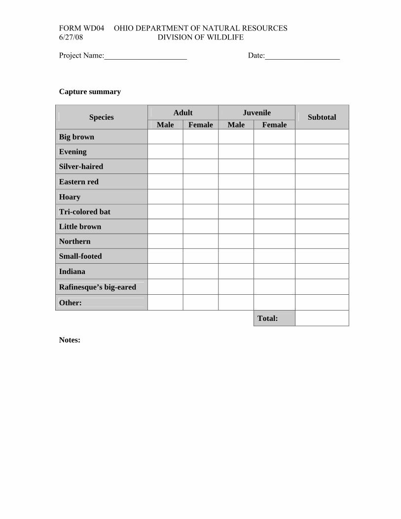
FORM WD04 OHIO DEPARTMENT OF NATURAL RESOURCES 6/27/08 DIVISION OF WILDLIFE
Project Name:_____________________ Date:___________________ Capture summary
Adult Juvenile Species Male Female Male Female
Subtotal
Big brown
Evening
Silver-haired
Eastern red
Hoary
Tri-colored bat
Little brown
Northern
Small-footed
Indiana
Rafinesque’s big-eared
Other:
Total: Notes:

FORM WD05 OHIO DEPARTMENT OF NATURAL RESOURCES Page____of____ 6/27/08 DIVISION OF WILDLIFE
BAT SURVEY FORM Project Name:___________________ Date:_________________
Measurements (millimeters and grams) Species Time
(military) Sex Reproductive status Forearm Ear Tragus Weight Net # Recapture/Band #
Species code: Big brown (EPFU), Silver-haired (LANO), Red (LABO), Hoary (LACI), Tri-colored (PESU), Rafinesque’s big-eared (CORO) 1, 2, Little brown (MYLU), Northern (MYSE), Small-footed (MYLE) 1, and Indiana (MYSO) 1, 2. Radio-telemetry, and documentation photographs required 1. Banding required 2.

FORM WD05 OHIO DEPARTMENT OF NATURAL RESOURCES Page____of____ 6/27/08 DIVISION OF WILDLIFE
Measurements (millimeters and grams) Species Time (military) Sex Reproductive
status Forearm Ear Tragus Weight Net # Recapture/Band #

FORM WD06 OHIO DEPARTMENT OF NATURAL RESOURCES Page__of___ 6/27/08 DIVISION OF WILDLIFE
FATALITY REPORTING FORM Date:__________________ Turbine #:_________ Searcher:______________________ Total number of fatalities found during search:___________ Start time:________________ End time:________________
Carcass ID1: Transect Information From Turbine Time Turbine # Carcass # Transect # Perp. Dist2(m) Obs. Dist3(m) Distance (m) Bearing
Species Age4 Sex5 Condition Alive / Dead Estimated time on ground6
Euthanized Yes / No GPS file: Scavenged Yes / No Veg. Height % Cover Photo ID Notes
Carcass ID: Transect Information From Turbine
Time Turbine # Carcass # Transect # Perp. Dist. (m) Obs. Dist. (m) Distance (m) Bearing
Species Age Sex Condition Alive / Dead Estimated time on ground Euthanized Yes / No
GPS file: Scavenged Yes / No Veg. Height % Cover Photo ID Notes
1 Carcass ID = MMDDYYYY - Turbine # - Fatality number for that search 4 Adult / Juvenile / Unknown 2 Perpendicular distance from transect 5 Male / Female/ Unknown 3 Distance from which the searcher detected the carcass 6 Last night / 2 – 3 days / 4 – 7 days / 7 – 14 days / > 2 weeks / Unknown

FORM WD06 OHIO DEPARTMENT OF NATURAL RESOURCES Page__of___ 6/27/08 DIVISION OF WILDLIFE
Carcass ID: Transect Information From Turbine
Time Turbine # Carcass # Transect # Perp. Dist. (m) Obs. Dist. (m) Distance (m) Bearing
Species Age Sex Condition Alive / Dead Estimated time on ground Euthanized Yes / No
GPS file: Scavenged Yes / No Veg. Height % Cover Photo ID Notes
Carcass ID: Transect Information From Turbine
Time Turbine # Carcass # Transect # Perp. Dist. (m) Obs. Dist. (m) Distance (m) Bearing
Species Age Sex Condition Alive / Dead Estimated time on ground Euthanized Yes / No
GPS file: Scavenged Yes / No Veg. Height % Cover Photo ID Notes
Carcass ID: Transect Information From Turbine
Time Turbine # Carcass # Transect # Perp. Dist. (m) Obs. Dist. (m) Distance (m) Bearing
Species Age Sex Condition Alive / Dead Estimated time on ground Euthanized Yes / No
GPS file: Scavenged Yes / No Veg. Height % Cover Photo ID Notes

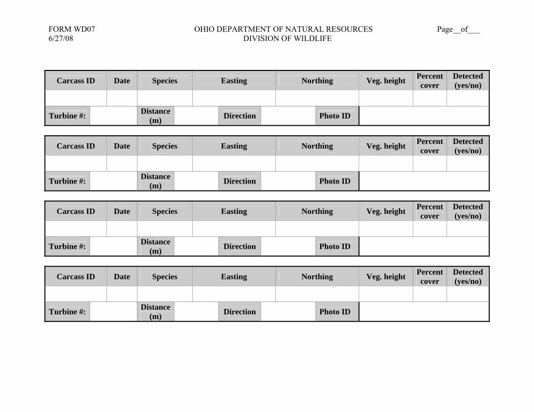
FORM WD07 OHIO DEPARTMENT OF NATURAL RESOURCES Page__of___ 6/27/08 DIVISION OF WILDLIFE
SEARCHER EFFICIENCY FORM
Carcass ID Date Species Easting1 Northing Veg. height Percent cover
Detected (yes/no)
Turbine #: Distance (m) Direction Photo ID
Carcass ID Date Species Easting Northing Veg. height Percent cover
Detected (yes/no)
Turbine #: Distance (m) Direction Photo ID
Carcass ID Date Species Easting Northing Veg. height Percent cover
Detected (yes/no)
Turbine #: Distance (m) Direction Photo ID
Carcass ID Date Species Easting Northing Veg. height Percent cover
Detected (yes/no)
Turbine #: Distance (m) Direction Photo ID
1 Coordinates should be recorded in UTM NAD83, Zone 17 North. Do not use Lat/Lon.
FORM WD07 OHIO DEPARTMENT OF NATURAL RESOURCES Page__of___ 6/27/08 DIVISION OF WILDLIFE
Carcass ID Date Species Easting Northing Veg. height Percent cover
Detected (yes/no)
Turbine #: Distance (m) Direction Photo ID
Carcass ID Date Species Easting Northing Veg. height Percent cover
Detected (yes/no)
Turbine #: Distance (m) Direction Photo ID
Carcass ID Date Species Easting Northing Veg. height Percent cover
Detected (yes/no)
Turbine #: Distance (m) Direction Photo ID
Carcass ID Date Species Easting Northing Veg. height Percent cover
Detected (yes/no)
Turbine #: Distance (m) Direction Photo ID


![1 Introduction - Cambridge University Pressassets.cambridge.org/97811070/37267/excerpt/...1 Introduction Bird,bat,andinsectflighthasfascinatedhumansformanycenturies.Asenthusiasti-callyobservedbyDial[1],mostspeciesofanimalsfly.Basedonhisacuteobservation](https://img.dokumen.tips/doc/110x75/5ad5c8627f8b9a6d708d4aa8/1-introduction-cambridge-university-introduction-birdbatandinsectighthasfascinatedhumansformanycenturiesasenthusiasti-callyobservedbydial1mostspeciesofanimalsybasedonhisacuteobservation.jpg)


