Embed Size (px)
Citation preview
53C13SE8142 2 .2594 SETTING NET LAKE 010
l oGEOPHYSICAL REPORT /*
ON A
MAGNETOMETER SURVEY
OF THE
VANTREAL RESOURCES MOLYBDENUM PROSPECT
SETTING NET LAKE AREARED LAKE MINING DIVISION
ONTARIO
NTS:53-C-13
BY
GEOPHYSICAL ENGINEERING LIMITEDSUITE 4900, TORONTO-DOMINION CENTRE
TORONTO, ONTARIO
NOVEMBER 24, 1977 J, A, KELLY,P, ENG,
PROPERTY
(a) No. of Claims
(b) Record Numbers
(c) Status
- 40
- KRL 450882-887 incl., KRL 500052-056 incl.,
KRL 483434-443 incl., KRL 391332-341 incl.,
KRL 503909-912 incl., KRL 503731-734 incl.
- all claims are believed to be in good
standing to at least August, 1978.
2. LOCATION
(a) N .T.S. - 53-C-12
(b) Lat. 52 0 45'30" N, Long. 52 0 35'30" W
(c) Geographic Ref. - north side of Setting Net Lake, 142 miles
N 04 0 E of Red Lake.
(d) Mining Division - Red Lake
(e) Claim Sheet Ref. - N. 2199 - Setting Net Lake.
3. ACCESS
(a) Summer
(b) Winter.
- via float-equipped aircraft from Red Lake,
- via aircraft or via winter tractor road
70 miles from the end of the all-weather
road between Red Lake and Berens River.
4. OWNERSHIP
The claims are held under option by Vantreal Resources Ltd.,
1175 West 15th Street, North Vancouver, B.C.

- 2 -
HISTORY OF EXPLORATION '
Following discovery of molybdenum mineralization in
1968, Minorex Limited and Conwest Exploration Company Limited
explored the mineralized zone by geological and magnetometer
surveys, sampling of test pits, and diamond drilling. Minorex
(Asbestos Corp.) drilled three short packsack holes and Conwest
carried out 3,550 feet of NQ drilling in 7 holes.
The area has been mapped at a scale of l inch = 1/4 mile
by the O.D.M.
6. GEOLOGY
The property is underlain by the Setting Net Lake Stock,
a porphyritic granodiorite and quartz monzonite intrusive
3 miles long northwestward and up to 1.5 miles wide at its
northern end. The stock intrudes a tightly folded and foliated
sequence of Archean metavolcanics and metasediments trending
northwesterly.
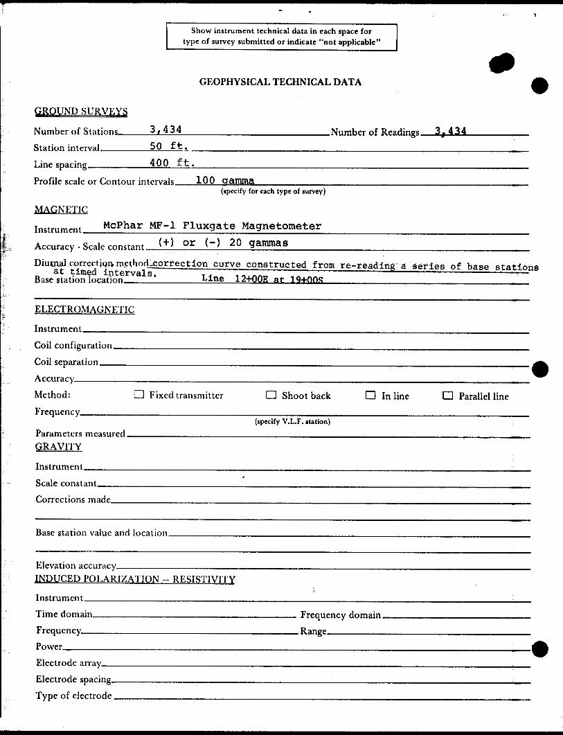
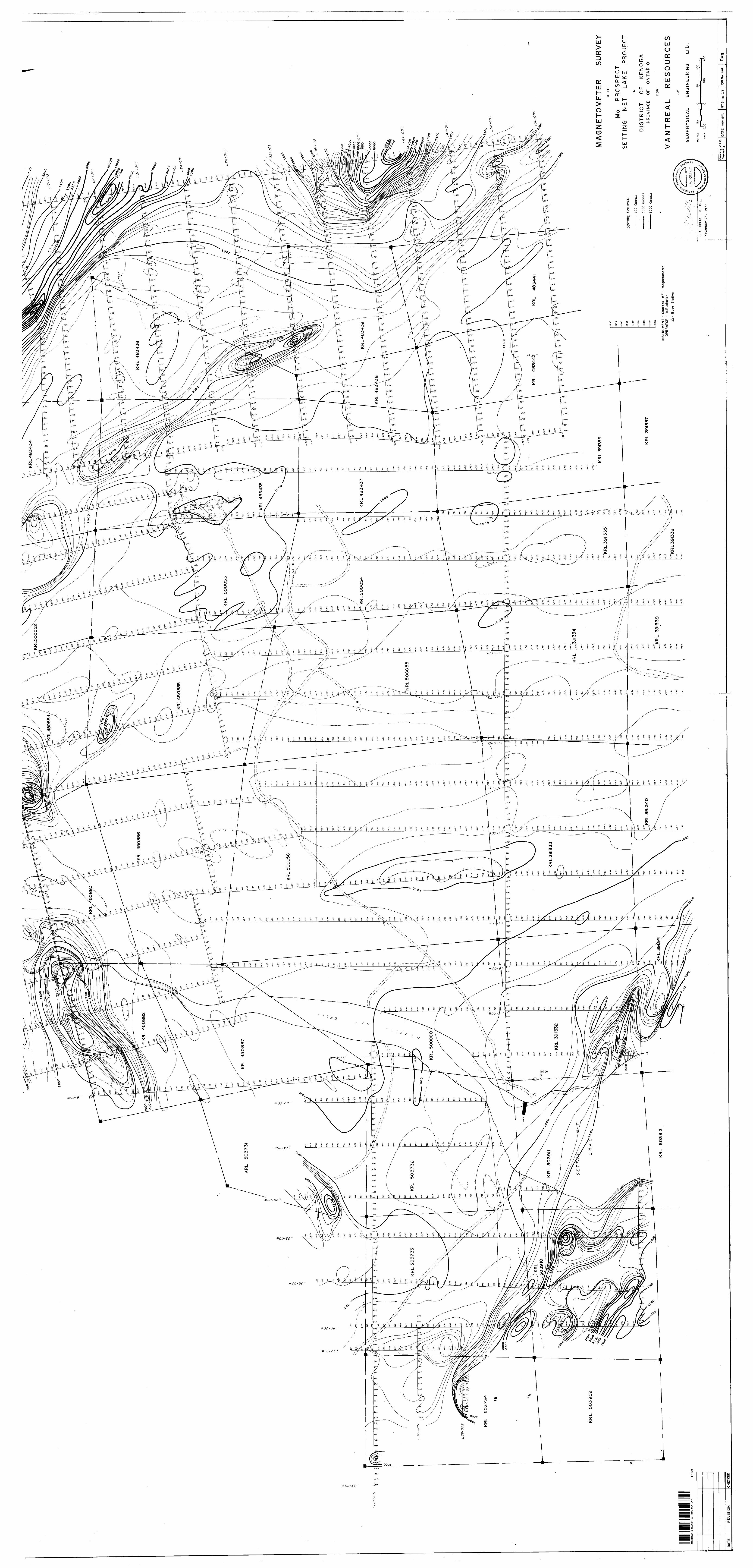
7. MAGNETOMETER SURVEY - 1977
(a) Purpose - to delimit the contacts of the granodiorite
stock, trace and/or outline cross-cutting
dykes or large inclusions of country rock
and to determine whether or not a molybdenite-
bearing fracture zone within the stock
exhibits an anomalous magnetic pattern which
might guide exploration.
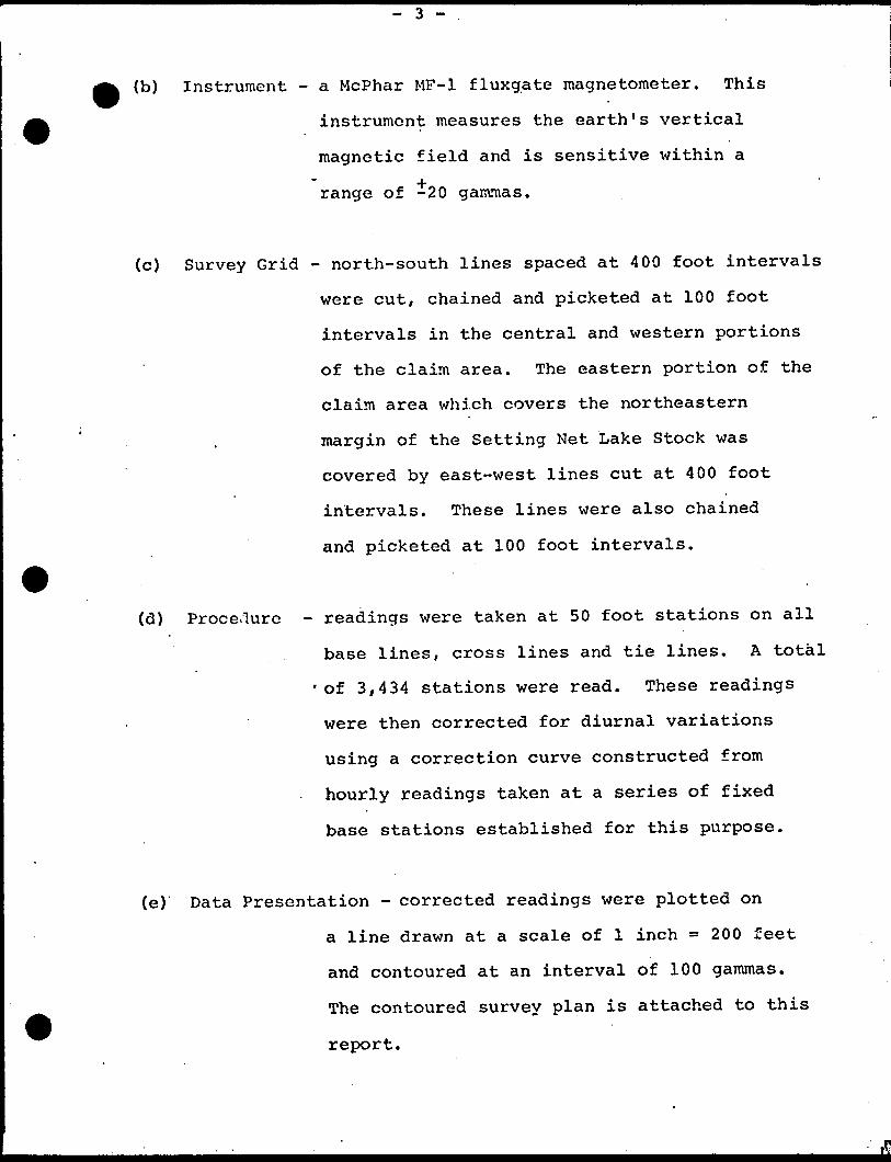
(b) Instrument - a McPhar MF-1 fluxgate magnetometer. This
instrument measures the earth's vertical
magnetic field and is sensitive within a
range of -20 gammas.
(c) Survey Grid - north-south lines spaced at 400 foot intervals
were cut, chained and picketed at 100 foot
intervals in the central and western portions
of the claim area. The eastern portion of the
claim area which covers the northeastern
margin of the Setting Net Lake Stock was
covered by east-west lines cut at 400 foot
intervals. These lines were also chained
and picketed at 100 foot intervals.
(d) Proce-lure - readings were taken at 50 foot stations on all
base lines, cross lines and tie lines. A total
of 3,434 stations were read. These readings
were then corrected for diurnal variations
using a correction curve constructed from
hourly readings taken at a series of fixed
base stations established for this purpose.
(e) Data Presentation - corrected readings were plotted on
a line drawn at a scale of l inch - 2 00 feet
and contoured at an interval of 100 gammas.
The contoured survey plan is attached to this
report.
- 4 -
) Results and Interpretation
The granitic rocks of the Setting Net Lake Stock
exhibit a flat, generally featureless magnetic pattern with
a magnetic relief of 300 gammas. Magnetic highs of 1,000 to
30,000 gammas surround the stock, probably reflecting the
contact effects of the stock on the surrounding metavolcanics,
metasediments, and iron formation.
O.D.M. preliminary Map No. 539 (Ayres, 1970) shows
the east boundary of the stock as a fault contact striking about
N20 0W. This feature appears to be delimited by the linear
magnetic features striking northwest through claims KRL 483439,
483436, 483435, and KRL 500052. The magnetic low in the
northeast portion of KRL 500052 may be underlain by a granite
apophysis but this is uncertain due to the lack of any outcrop
evidence in the general area.
Another northwest-trending fault, shown on the
geological map (Ayres, op.cit.) to be cutting and displacing
the stock in the north-central claim area, is not readily
apparent on the magnetic map. Its location might be approximated
by drawing a line joining the magnetic highs in northeast
KRL 450884, north-central KRL 450885, southwest KRL 500053,
and eastern KRL 500054.
The target area, the widespread zone of molybdenite-
bearing fractures, exhibits no magnetic features which could
be used to guide further exploration.
- 5 -
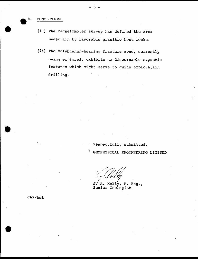
8. CONCLUSIONS
(i ) The magnetometer survey has defined the area
underlain by favorable granitic host rocks.
(ii) The molybdenum-bearing fracture zone, currently
being explored, exhibits no discernable magnetic
features which might serve to guide exploration
drilling.
Respectfully submitted,
GEOPHYSICAL ENGINEERING LIMITED
J A, Kelly, P. Eng., Senior Geologist
JAK/hmt
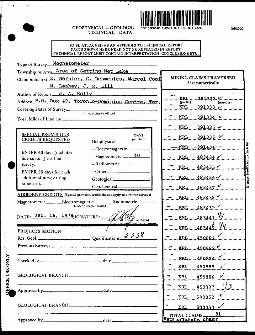
GEOPHYSICAL - GEOLOGIC TECHNICAL DATA
53CI3SE8142 2 .2594 SETTING NET LAKE 900
TO BE ATTACHED AS AN APPENDIX TO TECHNICAL REPORTFACTS SHOWN HERE NEED NOT BE REPEATED IN REPORT
TECHNICAL REPORT MUST CONTAIN INTERPRETATION. CONCLUSIONS ETC.
*
ia
li
Township nr AT- Area of Settincf Net Lake
claim hnirW(s) K. Bernier, G. Desmeules, Marcel CoolM. Leahey, J. R. Lill
Author nf Report J. A. Kelly
Address P.O. Box 49, Toronto-Dominion Ponfr'*, T^**Covering Dates "f Survy
(linccutting to office)
Total Miles nf I.inp rut
SPECIAL PROVISIONS DAYS CREDITS REQUESTED ^^ ,,^,1 per daim
F.WtrAmapnptirENTER 40 days (includes line cutting) for first Magnetometer iS
survey Radjnmpirjr
ENTER 20 days for each -Other
additional survey using fi lnmralsame grid.
fjpnrhprmraj,
AIRBORNE CREDITS (Special provision credits do not apply to airborne surveys)
Magnetometer F.lprtrnmafrnetir Rarlinmptrir(enter days per claim) s
DATE- Jan. 16, 1978;if;NATT!RF,' /f^^H''latffhot of Repalrt or Agent
PROJECTS SECTION ' G
Res. Geol. Onalifirations CX.o(.3
Previnus Surveys
ChprkeH hy flare
GEOT,OnirAT,HRANrH
Approved hy Hate
r.ROT nr.ir A T K R A MP H
Approved hy d a tp
MINING CLAIMS TRAVERSED List numerically
r
(prefix) " (number)
" KRL 391333 t/
^ KRL 391334 t.
*~ KRL 391335 ^
*. VOT O 0 1 OOC tS ^^ J\ZvLi JpXJjy
" "' " I\Zuj J y i fl iJ Q
KRL 483^34 l/
- KR^ 4834.35*-
- KRL. 4834.36^
- KR^ 493437 ^
SRL. 483438 *
- W* 4B34.3.9 ^
1 ^C ij
KRL 483.4.412 ' V
"" KRL 4,5A882...^..................
' KJRL 450883^
~ KJRL A50884 ^
' KRL 450885 t/
KRL 450886 r
*" KRL 450887 /3
* KRL 500052 *
KRL 500053 y
. TOTAI.n.ATMS 3 1 ,-*SEE ATTAJ5.I46I-. fiHtRT
Show instrument technical data in each space for type of survey submitted or indicate "not applicable"
GEOPHYSICAL TECHNICAL DATA
GROUND SURVEYS
Number of Stations ____ 3,434 ____________________ Number of ReadingsStation interval _______ 50 f t.Line spacing ________ 400 ft.Profile scale or Contour intervals 100 gamma ____________ .———^^—^—
(specify for each type of survey)
MAGNETIC Instrument McPhar MF-1 Fluxgate Magnetometer ——^—^^—--——
Accuracy - Scale mutant W o* M 20 gammas
Diurnal correction, method^correction curve constructed from re-reading a series of base stationsLine 12+OQE at 19+nns ——————————————^—— ,
ELECTROMAGNETIC
Instrument ———-^^^Coil configuration. Coil separation ——.Accuracy—^—^-—Method: O F ixed transmitter O Shoot back d In line D Parallel lineFrequency^^——^^—^^—.——-^^^——..—.—^^-^^——^^—.———.^^^^—-^—-——.—-.1———.--—^——
(specify V.L.F. station)
Parameters measured________________________________________________________. GRAVITY
Instrument.Scale constant.Corrections made.
Base station value and location.
Elevation accuracy-—^^^^———————^^ INDUCED POLARIZATION - RESISTIVITY
Instrument^—-^—^————————^^——Time domain___________________________ Frequency domain.Frequency_____________________________ Range^—^-.^——Power™——^-^^^^—————————^^—-——^——————.^^^-^^-—-—Electrode array-—. Electrode spacing- Type of electrode ,
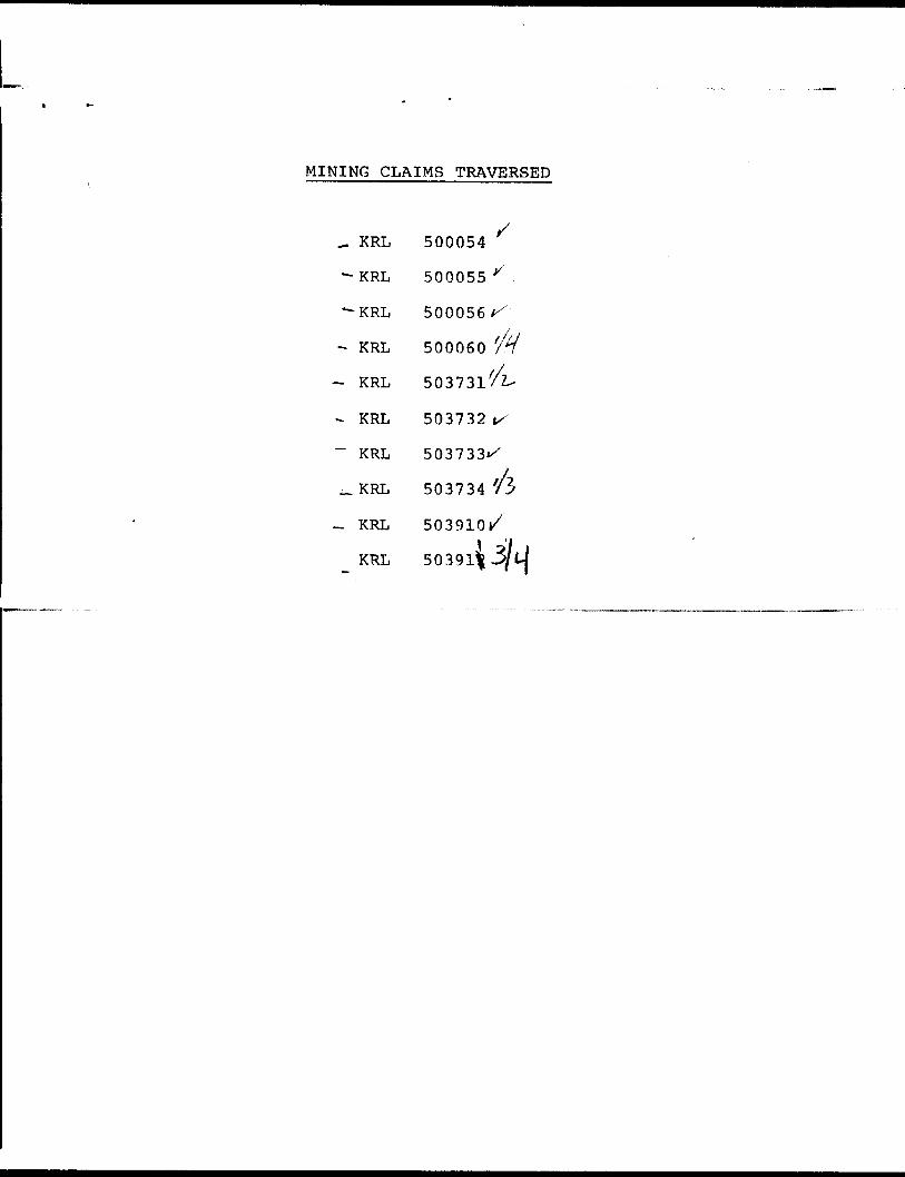
MINING CLAIMS TRAVERSED
^ KRL 500054
-KRL 500055^
-KRL 500056^
- KRL 500060
- KRL 503731/2-
- KRL 503732 t/
~ KRL 503733*^
503734 /3
~ KRL 503910 1/
KRL 50391^

CJ
l
oQ.
o CO
O)
o
-Qoo .o
North Trout Lake Area-M.288393945' 93? 30'
;-. '. . .••.•^•??L ,^153^8 43339 ^f K- R-I-
tiV r5!" ̂ "32 J M/^-g
^••••:\^iJ' : 'y.^-y^''^-^22-^:.". softd'.'.'X.'ft
3?0// 45329 X /*344/ 52193
**XfJn j rouuuoz 148349'*7*^7liTinoTirfc^~'lT7-~~ — .T?T —
^3*i50Dp60L \ — l "^T30^n u m uiii T . " "
503909 j5039K
—341 ,391340 [591339
\ l 484177 1484176 '506741 l 50674# l
0 ' \ \ \ V '506743" 484174\| 48417 5484164I l *r*"- ' -J.—,** l l1 ^ •"06744 ' ' k
IKRL~ i K'HL "l~KRr ~l rk K^ i t i \
V 506747 l |484I73 4S4I72 n o uofttf |506748 \
~"~KRL \T~ KRL \, KRL l KRL l KRL i KRL
484166 \,488I67 1484168 484169 .484170 '464171
Setting
36762 36761 36760 C .
520 45*
—52052'30'
52
51
50'
49'
48'
47
46
in oo GO cui oO*
O)
o
"D
5
— 52045'43' 42' 41' 40' 39' 38' 37' 36 35' 34' 33' 32 31'
93 030*
Setting Net Creek Area - M. 306953C13SE8142 2.2594 SETTING NET LAKE
Bob K.200 527933
AREA OF
SETTING NET LAKEDISTRICT OF KENORA
PATRICIA PORTION
RED LAKE MINING DIVISION
SCALE: l-INCH ri 4O CHAINS
LEGEND
PATENTED LANDCROWN LAND SALELEASES
LOCATED LANDLICENSE OF OCCUPATIONMINING RIGHTS ONLY
SURFACE RIGHTS ONLYROADS
IMPROVED ROADS
KING'S HIGHWAYS
RAILWAYS
POWER LINES
MARSH OR MUSKEG
MINES
CANCELLED
C.S.
c.
NOTES
400* Surface Rights Reservation along
the shores of all lakes and rivers.
DATE OF ISSUE
JAN 241978
SURVEYS AND MAPPING
NATIONAL TOPOGRAPHIC SERIES 53 C 13
PLAN NO. M.2I99
ONTARIO
MINISTRY OF NATURAL RESOURCESSURVEYS AND MAPPING BRANCH

LO
CA
TIO
NM
AP
94
*0
0'
o-oo
Sca
le
l 25
0,O
OO
L2
8+
OO
S
KR
L 4
83
43
4K
RL5
OO
052
KR
L45
088
4
"*0K
RL
450886
/(O
0K
RL
48
34
36
4508
82
KR
L45
088
5
KR
L 500053
450887
KR
L 5
03
73
1
r0
KR
L 483435
KR
L 5
00
05
6
KR
L5
00
05
4K
RL
48
343
7K
RL483439
KR
L 483438
KR
L 503732
KR
L5O
OO
55
KR
L 500
060
KR
L 5
03
73
4
KR
L 5O
39IO
KR
L 4
83
44
2K
RL
4834
41K
RL 5
0391
1K
RL
3913
33K
RL
3913
32
KR
L 5
03
90
9L
A K
E's
ocs C
OS
44
+O
OS
L28+
OO
S
53C
13S
E8142
2.2
59
4
SE
TT
ING
N
ET
LAK
E
DA
TE
RE
VIS
ION
KR
L 4
834
34
KR
L50O
052
KR
L450884
"KR
L 4
50886
1,00
KR
L 4
83
43
6
KR
L 4
50882
KR
L450885
KR
L 50
0053
KR
L
450887
KR
L
503731
KR
L 483435
KR
L 5
00
O5
6
KR
L5
00
05
4K
RL
483437
KR
L4
83
43
9
10
00
0
1500
0K
RL
483438
KR
L 5
00
05
5K
RL
50
37
33
KR
L 503732
KR
L 5
O0060
KR
L 503734
KR
L 50391
0
KR
L
48
34
42
KR
L
48
34
41
KR
L 5O
39II
KR
L 3
91333
KR
L 3
91
332
KR
L
50
39
09
KR
L 3
9133
6K
RL
391
33
5
KR
L 3
91
34
0K
RL
391337
KR
L
391
339
KR
L
50
39
12
KR
L3
9I3
38
MA
GN
ET
OM
ET
ER
S
UR
VE
YO
F
TH
E
CONT
OUR
INTE
RVAL
S
100
Gam
mas
1000
Ga
mm
as
5000
Gam
mas
Mo
PR
OS
PE
CT
S
ET
TIN
G
NE
T
LA
KE
P
RO
JEC
TN
INS
TR
UM
EN
T
OP
ER
ATO
RS
ho
rpes
M
F-I
M
agn
eto
met
er.
W.R
.Mari
on
A :
Bas
e S
tati
on
DIS
TR
ICT
O
F K
EN
OR
AP
RO
VIN
CE
O
F O
NT
AR
IO
FO
R
VA
NT
RE
AL
RE
SO
UR
CE
S
21
0
CH
EC
KE
D
J.A
. KE
LLY
P.
Eng.
Nov
embe
r 28
, 19
77
GE
OP
HY
SIC
AL
BY
EN
GIN
EE
RIN
G
LTD
ME
TR
ES
50
50
10
0
FE
ET
200
200
40
0
Dra
wn
by -
C.E
.K.
Che
cktd
by
DA
TE
N
OV
19
77.
NT
S.
53 C
/ BJO
B N
o.
M68
Dwg.
1