Embed Size (px)
Citation preview
MagMapTM Processing Software forMagnetometer Survey Data
This powerful Windows program provides basic data processing filters for quick analysis of magnetic, OhmMapper, and EM61 data.MagMapTM facilitates data download from Geometrics magnetom-eters, applies diurnal correction upon export, and generates 2D/3D color contour plots and shaded relief maps. This program also offers full GPS support with UTM conversion, sensor-GPS antenna offset computation as well as GPS file integration with basic magnetic data.
Erroneous data due to spikes can be eliminated with the despik-ing function by using a user-selectable maximum and minimum window to cut the data outside of this range. Dropouts due to entering a dead zone or loss of signal can be removed entirely or interpolated to estimate the actual values.
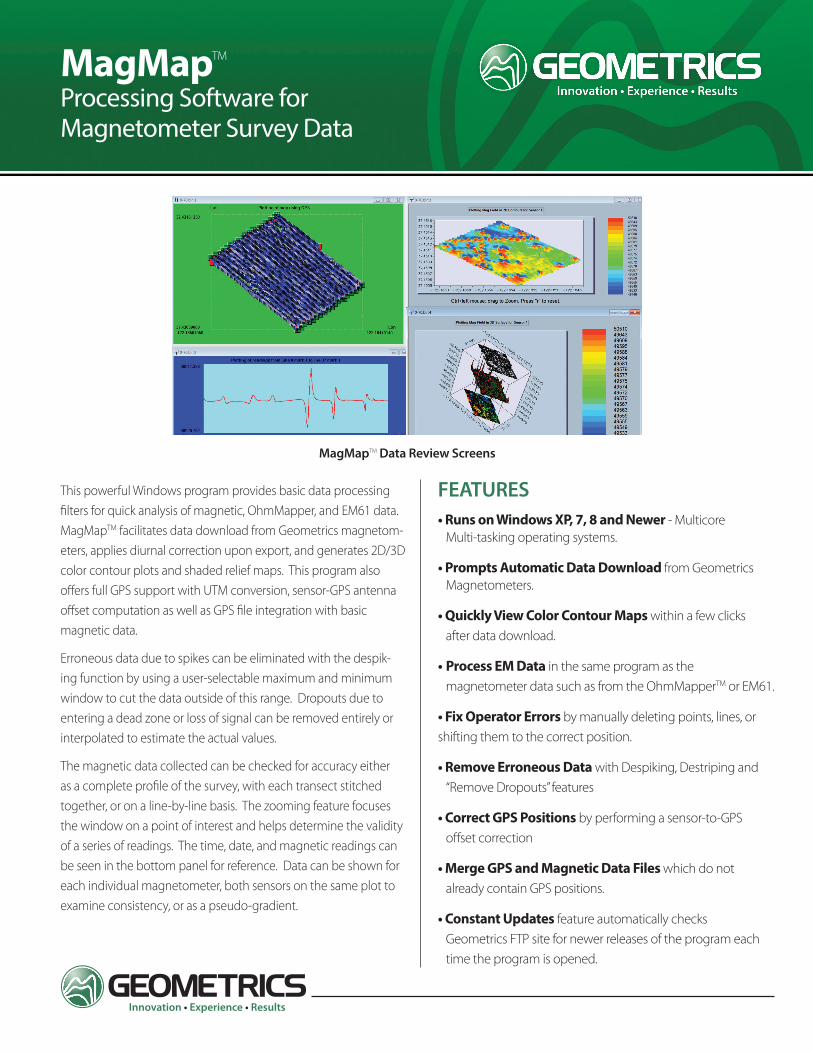
The magnetic data collected can be checked for accuracy either as a complete profile of the survey, with each transect stitched together, or on a line-by-line basis. The zooming feature focuses the window on a point of interest and helps determine the validity of a series of readings. The time, date, and magnetic readings can be seen in the bottom panel for reference. Data can be shown for each individual magnetometer, both sensors on the same plot to examine consistency, or as a pseudo-gradient.
MagMapTM Data Review Screens
FEATURES• Runs on Windows XP, 7, 8 and Newer - Multicore Multi-tasking operating systems.
• Prompts Automatic Data Download from Geometrics Magnetometers.
• Quickly View Color Contour Maps within a few clicks after data download.
• Process EM Data in the same program as the magnetometer data such as from the OhmMapperTM or EM61.
• Fix Operator Errors by manually deleting points, lines, or shifting them to the correct position.
• Remove Erroneous Data with Despiking, Destriping and “Remove Dropouts” features
• Correct GPS Positions by performing a sensor-to-GPS offset correction
• Merge GPS and Magnetic Data Files which do not already contain GPS positions.
• Constant Updates feature automatically checks Geometrics FTP site for newer releases of the program each time the program is opened.

MagMap_v1 (0417)
SPECIFICATIONS | MagMap Processing Software for Magnetometer Survey Data
GEOMETRICS INC. 2190 Fortune Drive, San Jose, California 95131, USA Tel: 408-954-0522 • Fax: 408-954-0902 • Email: [email protected]
GEOMETRICS EUROPE 20 Eden Way, Pages Industrial Park, Leighton Buzzard LU7 4TZ, UK Tel: 44-1525-383438 • Fax: 44-1525-382200 • Email: [email protected]
GEOMETRICS CHINA Laurel Geophysical Instruments Limited8F. Building 1 , Damei Plaza, 7 Qingnian Road, Chaoyang District, Beijing, 100025 ChinaTel: +86-10-85850099 • Fax: +86-10-85850991 • [email protected]
ANALOG COMPONENTSMagMap also downloads data from the OhmMapper and can create 2D image plots showing differences in the resistivity of the survey area. Using multiple receivers for a survey also allows you to create multiple depth slices to see how the resistivity changes at different depths, as well as creating vertical profiles of a transect. GPS offsets can be incorporated to properly position the resistivity data.
Specifications subject to change without notice.
Correcting GPS Data for Offsets
MERGING GPS AND MAGNETIC DATA FILES If you collect magnetic data and do not have an integrated GPS unit you can still merge both datasets in MagMap. It is important that both files contain accurate time stamps and were recorded simultaneously to marry the two datasets together. It is neces-sary to download GPS Babel prior to attempting to merge GPS and magnetic data. A link to the download website is provided in the software. GPS CORRECTIONS
MagMap allows the user to include GPS offsets to correctly associate location information with each magnetic data point. Smoothing parameters are also available to reduce relative positioning errors in the GPS readings.
2D/3D GRID VIEWS Data can be seen in a traditional 2D image plot or shaded relief to examine the size and nature of each anomaly. The 3D plot is a colored wireframe plot to give a visual representation of the strength of each anomaly as well as a comparison between two features. The 3D grid option also allows you to zoom in on areas of interest for a closer examination of subtle differences in the data.
DATA DESTRIPINGHeading and operational errors can be removed with the destriping function. It also employs a high frequency filter to remove small sinusoidal noise typically representative of the walking gait of the operator.
Results of Destriping and Periodic Noise Removal Feature
Map of OhmMapper Resistivity Data