Embed Size (px)
Citation preview
8/2/2019 OK - MOBILE - iZone a Location-Based Mobile Social Networking System
http://slidepdf.com/reader/full/ok-mobile-izone-a-location-based-mobile-social-networking-system 1/6
iZone: A Location-Based Mobile Social Networking System
Rui Cheng, Zhuo Yang, Feng XiaSchool of Software, Dalian University of Technology, Dalian 116620, China
Abstract —The rapid development of wireless technology, the
extensive use of mobile phones and the availability of location
information are facilitating personalized location-based
applications. Easy to carry, easy to use and easy to buy, smart
phones with certain software are of great advantage.
Consequently, mobile social networking (MSN) systems have
emerged rapidly, being a revolution for our everyday life.
Based on the analysis of general requirements of MSN and
location-based services (LBS), this paper presents the design of
iZone, a mobile social networking system, as well as a
prototype implementation. This platform exploits mobile GIS
(Geographic Information Systems), LBS and J2ME
technologies, combining geographical data to display map onmobile phones. It can provide a number of social networking
services via smartphones.
Keywords-mobile social networking; smart phone; location-
based services; mobile geographic information systems
I. I NTRODUCTION
Social networking is a relatively new and still developingfield that focuses on the analysis of social relationship.Human beings can only survive, mature, and reach self-actualization in social networking. Social networking puts itsattention on social objects as, for instance, members of anassociation, employees of a firm, firms themselves and so on.Both theoretical advances and real-life applications are booming day by day [1, 2, 3]. Social networking exists sincehuman beings exist. We live, work in it and may never feel it.In the history of mankind, one important technologyrevolution is sure to be associated with media revolution. Allactivities of human are essentially activities of information.During that phase time and material cost are continuouslyreduced by human in social networking. Cost-efficient mediais always popular with human.
In 21st century, mobile phones are growing in popularityall around the world. Mobile phone has developed from atool for chatting to a necessary friend in social networking.As it has more and more useful functions in socialcommunication, it has gradually become an indispensable
part of people's life [4]. In this case, mobile socialnetworking (MSN) system emerges at a historic moment.Mobile social networking is a typical social network whereone or more individuals of similar interests or commonalities,conversing and connecting with one another using mobile phones [5]. In the information age, it seems that peoplecommunicate using mobile devices every day.
People now do not stay in one area and move often.Cities are expanding and changing all the time, which makes people confused about the position and location. Location-
based services (LBS) appear to meet people’s need aboutlocation. Since Google Map started, many other companiesalso launched similar services to bring more convenience to people. It is not hard to see that location-based mobile socialnetworking systems are sure to become popular.
This paper will have a glance at some popular relatedwork all over the world in Section II, and then anatomizesMSN and LBS in Section III. We present the design of iZone,a mobile platform of location-based social networkingsystem in Section IV. It has a number of functionssupporting chatting with friends, reading the map, fixing the
position, reading the news, reporting the weather and so forth.In Section V, we describe a prototype implementation of theiZone system. Section VI concludes the paper.
II. R ELATED WORK
MSN systems are developing fast around the world.There are many examples of commercialized operations. For instance, Plazes is a location-aware interaction system thathelps mobile users hook up with friends or other like-minded people anywhere on the globe. Jambo Networks uses Wi-Fi-enabled laptops, mobile phones, and PDAs to match peoplewithin walking distance who have similar interests andwould like to meet face to face [6]. Friendster, Dodgeball,and Facebook are three examples to promote discovery and
interaction with both friends and strangers [7]. Amazonallows users to review products but no friendship amongusers can be defined. On the other hand, Facebook has anexplicit friendship circle defined by individual users who getautomatic updates on their friends’ activities [8]. MSN ismeanwhile a booming industry in China. China Mobilelaunched Making Friends in Fetion, which led the trend of mobile social networking in China [9].
LBS is also developing at a high speed. For instance, BellCompany in Canada is one of the market leaders of LBS. Itlaunched services of amusement, information, calling for help based on location in December of 2003. Although MyFinder is well-known around the world, it still gets rid of thestale and brings forth the fresh and offered Swordfish - a
mobile game based on GPS in which it diminishes the earthinto a measured fishpond. Until 2008, mobile phonessupporting GPS have occupied 25 percent of all andapplications are also multifarious [10, 11]. In China, LBSalso has recognition in traffic area. By the end of 2009,according to incompletely statistics, scores of provinces haveaccomplished tracking implementation on taxi and bus,which covers vehicle position tracing, vehicle speedmanagement and vehicle scheduling.
The importance of geographical information systems(GIS) grows with each passing day in the information-based
3rd International Symposium on Parallel Architectures, Algorithms and Programming
978-0-7695-4312-3/10 $26.00 © 2010 IEEE
DOI 10.1109/PAAP.2010.67
33
8/2/2019 OK - MOBILE - iZone a Location-Based Mobile Social Networking System
http://slidepdf.com/reader/full/ok-mobile-izone-a-location-based-mobile-social-networking-system 2/6
process of national economy. Since 2000, GIS got sufficientdevelopment in the world, produced enormous economic and brought large social benefit [12]. Mobile GeographicInformation System (Mobile GIS) is a product of embeddedsystems which has installed GIS in them. It is also an idealsolution for resource management, resource configuration,urban planning and management, land information system
and cadastral application, environmental management andmodeling, emergency response and so on [13, 14].
III. BACKGROUND
A. Mobile Social Networking
Mobile social networking occurs in virtual communities just the same as web based social networking. Some socialnetworking websites start to turn mobile such as MySpaceand Facebook, which has become a trend many companiesadopt. Meanwhile, native mobile social networks have beencreated like Foursquare and Gowalla. Initially, there weretwo basic types of mobile social networks. The first iscompanies that partner with wireless phone carriers to
distribute their communities via the default start pages onmobile phone browsers. An example is Juice Caster. Thesecond type is companies that do not have such carrier relationships and rely on other methods to attract users [15].Many web based social networking companies turn mobile because more people use mobile phones to communicate andit has become a business opportunity for them. It isinconvenient for people to have computer some time andmobile phone comes into useful. Chips and cores of mobile phone are being improved in a wing-footed speed. As aresult, social networking on mobile phones becomes anecessity. On the other hand, mobile social networkingsystems are updating quickly to meet people’s needs oncommunication.
Client 1
Client 2
Wireless Access
Network
Internet
Server
Wireless
Access Network
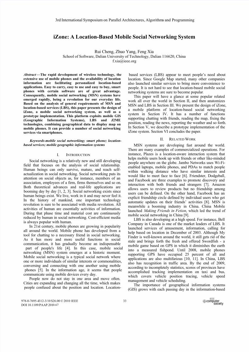
Figure 1. Structure of a MSN system
As shown in Fig. 1, a mobile social networking systemgenerally consists of four main components: the clientdevices, the wireless access network, the Internet and theserver side.
Client Devices must have a location module, which canreceive and send data. Most mobile phones now can run Javasoftware which has the function of location. Wi-Fi or GPS
are commonly used to estimate the current location of theuser. GPS requires a clear view of sky to function properly.Therefore, for the need of social services that take place inindoor environments, Wi-Fi location technology can beutilized instead of GPS [16].
The Wireless Access Network works as TCP/IP pipes.Users have to set up one basic station in a sufficient distance.By employing a proper architecture [17], changes made tothe core cellular network could be minimized by e.g.removing carrier assisted positioning.
The Internet component consists of third partyapplication servers such as SMTP Mail Server, VoIP Server,and Map Server. There are publicly available map serversthat can be utilized for MSN, and that provide well-defined,
albeit proprietary, APIs. The application servers in theInternet component can also be deployed in the Server Side.
The Server Side is the core of the system. It consists of Web Server, Location Database, Profile Repository,Matching Logic and Privacy Control. When the requestcomes, it goes through these five sections and finally sends aresponse to the users.
B. Location-Based Services
LBS systems often provide a kind of service thatconfirms user's actual geographical position by connection of mobile terminal and mobile network, thus meeting users'needs on information about location.
LBS can be used in a variety of aspects in our life, such
as healthcare, friends making, security tracing and so forth.LBS includes services to identify the location of a person or object, such as discovering the nearest banking cash machineor the whereabouts of a friend or employee. Examples of LBS include parcel tracking and vehicle tracking services.They can include mobile commerce when taking the form of coupons or advertising directed at customers based on their current locations. They also include personalized weather services and even location-based games. These applicationsare typical examples of telecommunication convergence.
There are several localization methods available. Thefirst is control plane localization. Sometimes it referred to as positioning with controlled plane. Service provider gets thelocation based on the radio signal delay of the closest cell- phone towers (for phones without GPS features) which can be quite slow as it uses the voice control channel [18]. LBSsystems use a single base station, with a radius of inaccuracy,to determine a phone's location. This technique was the basisof the E-911 mandate and is still used to locate mobile phones as a safety measure. Latest smartphones and PDAstypically have an integrated A-GPS chip.
In order to provide a successful LBS technology thefollowing factors must be met:
34
8/2/2019 OK - MOBILE - iZone a Location-Based Mobile Social Networking System
http://slidepdf.com/reader/full/ok-mobile-izone-a-location-based-mobile-social-networking-system 3/6
y Coordinates accuracy requirements that aredetermined by the relevant services;
y Lowest possible cost;y Minimal impact on network and equipment.Several categories of methods can be used to find the
location of the subscriber. The simple and standard solutionis GPS-based LBS. Sony Ericsson's Near Me is one such
example. It is used to maintain knowledge of the exactlocation. However, this can be expensive for the end-users,as they would have to invest in a GPS-equipped handset.GPS is based on the concept of trilateration, a basicgeometric principle that allows finding one location if oneknows its distance from other already known locations.
GSM localization is the second option. Finding thelocation of a mobile device in relation to its cell site isanother way to find out the location of an object or a person.It relies on various means of multilateration of the signalfrom cell sites serving a mobile phone [19]. Thegeographical position of the device is found out throughvarious techniques like time difference of arrival (TDOA) or Enhanced Observed Time Difference (E-OTD).
Another method is Near LBS (NLBS), in which local-range technologies such as Bluetooth, WLAN, infraredand/or RFID/Near Field Communication technologies areused to match devices to nearby services [20]. This techniqueallows a person to access information based on their surroundings, especially suitable for using inside closed premises, restricted/ regional areas.
Another alternative is an operator- and GPS-independentlocation service based on access into the deep level telecomsnetwork (SS7) [21]. This solution enables accurate and quick determination of geographical coordinates of mobile phonenumbers by providing operator-independent location dataand works also for handsets that are not GPS-enabled.
Many other local positioning systems are available,
especially for indoor use. GPS and GSM don't work verywell indoor, where other techniques are often used, includingBluetooth, UWB, RFID and Wi-Fi.
IV. IZONE SYSTEM DESIGN
iZone is designed to be a comprehensive, secure,convenient and easy-handling platform. It is a J2ME projectthat can run on mobile devices which support CLDC 1.0 andMIDP 2.0. This platform is a type of intelligent location- based system which combines GIS and location information.iZone can collect position data and other space information,then automatically extract things that may be interested byusers, and finally send them to the users in a humanizingform. Meanwhile, it offers users some social networking
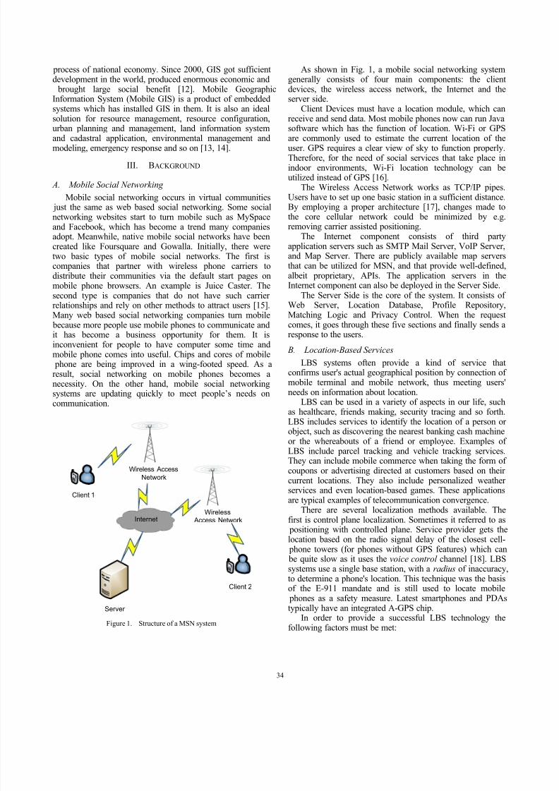
services, such as instant messaging, blog publication, photouploading and position tracing based on users' location.As shown in Fig. 2, iZone is mainly divided into the
following seven subsystems: Registration and LoginSubsystem, Map Subsystem, Homepage Subsystem, FriendSubsystem, Mail Subsystem, Local Information Subsystemand Setting Subsystem.
Each subsystem can also be divided into several modules.Registration and Login Subsystem consists of login moduleand registration module. Map Subsystem consists of local
search module and on-line friends module. HomepageSubsystem consists of friend news module, gateway module, personal information module, blog module and albummodule. Friend Subsystem consists of friend managementmodule and friend communication module. Mail Subsystemis an individual system. Local Information Subsystemconsists of local weather report module, local news module
and local forum module. Setting Subsystem consists of privacy setting module and information setting module.
Local
Information
iZone
Register
Login
Setting
Friend
Homepage
Map
Figure 2. iZone system structure
A. Registration and Login Subsystem
Registration and Login Subsystem is the first subsystemthe user will meet when using this software. It consists of
registration and login modules. In Registration module, usersmust fill in some basic information such as unique user name, password, nickname, E-mail, phone number and gender.When the registration apply was authenticated, the server will send a short message to user's mobile phone and then theuser can login. Only by inputting correct user name and password, can the user login successfully.
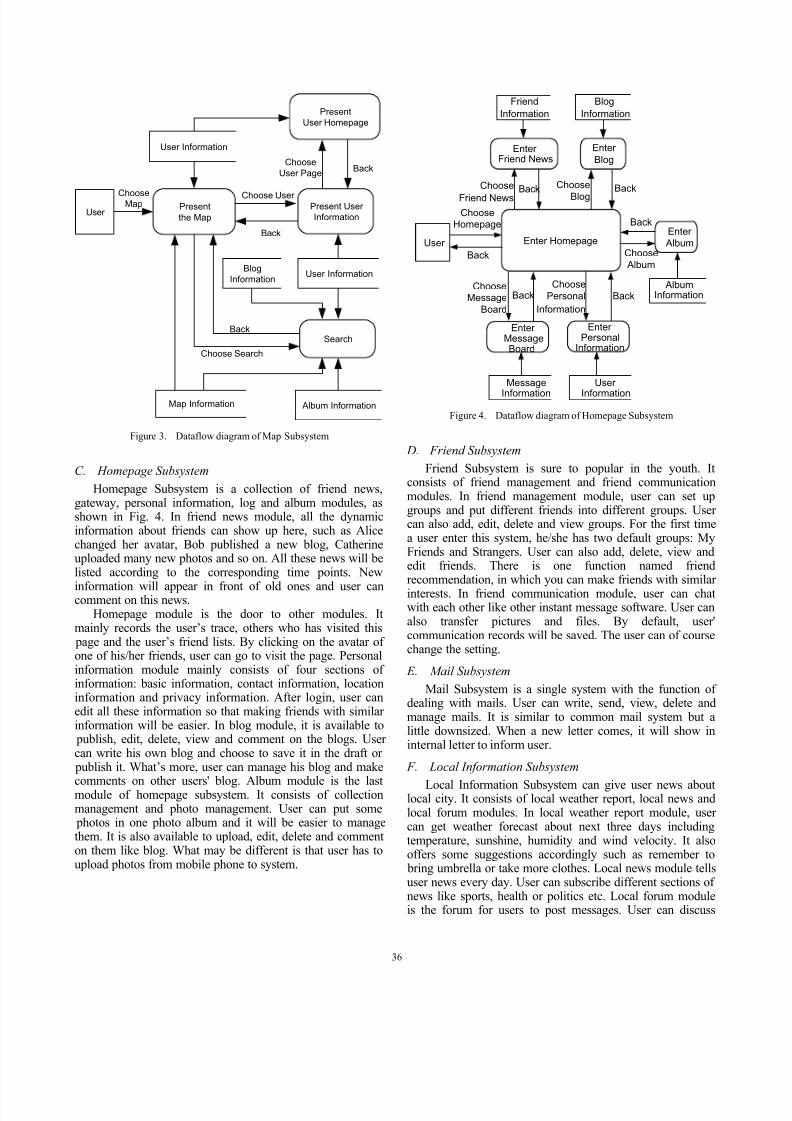
B. Map Subsystem
After login, the user can see the default subsystem, MapSubsystem, as shown in Fig. 3. It is the core of location based system. It consists of local search and on-line friendsmodules. In local search module, the user can search localusers, local restaurants, and local hospitals and so on. It is alively guide for a visitor. User can also choose typical view
and satellite view. In on-line friends module, user can seeother nearby users on the map. Some further information (e.g.nickname, gender, and status) of a certain user will be shownif his/her avatar is pointed at. Moreover, the map has thefunction of Zoom In and Zoom Out. It is easy to change themap size.
35
8/2/2019 OK - MOBILE - iZone a Location-Based Mobile Social Networking System
http://slidepdf.com/reader/full/ok-mobile-izone-a-location-based-mobile-social-networking-system 4/6
User Present
the Map
Map Information
User Information
Present User
Information
Present
User Homepage
Search
User InformationBlog
Information
Album Information
ChooseMap
Back
Choose Search
Back
Choose User
BackChoose
User Page
Figure 3. Dataflow diagram of Map Subsystem
C. Homepage Subsystem
Homepage Subsystem is a collection of friend news,gateway, personal information, log and album modules, asshown in Fig. 4. In friend news module, all the dynamicinformation about friends can show up here, such as Alicechanged her avatar, Bob published a new blog, Catherineuploaded many new photos and so on. All these news will belisted according to the corresponding time points. New
information will appear in front of old ones and user cancomment on this news.Homepage module is the door to other modules. It
mainly records the user’s trace, others who has visited this page and the user’s friend lists. By clicking on the avatar of one of his/her friends, user can go to visit the page. Personalinformation module mainly consists of four sections of information: basic information, contact information, locationinformation and privacy information. After login, user canedit all these information so that making friends with similar information will be easier. In blog module, it is available to publish, edit, delete, view and comment on the blogs. User can write his own blog and choose to save it in the draft or publish it. What’s more, user can manage his blog and make
comments on other users' blog. Album module is the lastmodule of homepage subsystem. It consists of collectionmanagement and photo management. User can put some photos in one photo album and it will be easier to managethem. It is also available to upload, edit, delete and commenton them like blog. What may be different is that user has toupload photos from mobile phone to system.
User Enter Homepage
Enter Friend News
Enter
Blog
Enter
Album
Enter MessageBoard
Enter Personal
Information
Message
Information
User
Information
AlbumInformation
Blog
Information
Friend
Information
ChooseHomepage
Back
Back Back
Back
BackBack
Choose
Friend News
ChooseMessage
Board
Choose
Personal
Information
Choose
Blog
Choose
Album
Figure 4. Dataflow diagram of Homepage Subsystem
D. Friend Subsystem
Friend Subsystem is sure to popular in the youth. Itconsists of friend management and friend communicationmodules. In friend management module, user can set upgroups and put different friends into different groups. User can also add, edit, delete and view groups. For the first timea user enter this system, he/she has two default groups: MyFriends and Strangers. User can also add, delete, view andedit friends. There is one function named friendrecommendation, in which you can make friends with similar
interests. In friend communication module, user can chatwith each other like other instant message software. User canalso transfer pictures and files. By default, user'communication records will be saved. The user can of coursechange the setting.
E. Mail Subsystem
Mail Subsystem is a single system with the function of dealing with mails. User can write, send, view, delete andmanage mails. It is similar to common mail system but alittle downsized. When a new letter comes, it will show ininternal letter to inform user.
F. Local Information Subsystem
Local Information Subsystem can give user news aboutlocal city. It consists of local weather report, local news andlocal forum modules. In local weather report module, user can get weather forecast about next three days includingtemperature, sunshine, humidity and wind velocity. It alsooffers some suggestions accordingly such as remember to bring umbrella or take more clothes. Local news module tellsuser news every day. User can subscribe different sections of news like sports, health or politics etc. Local forum moduleis the forum for users to post messages. User can discuss
36
8/2/2019 OK - MOBILE - iZone a Location-Based Mobile Social Networking System
http://slidepdf.com/reader/full/ok-mobile-izone-a-location-based-mobile-social-networking-system 5/6
based on politics, social phenomenon and so on. User canalso respond others in the forum. There are also someadministrators to examine and verify messages.
G. Setting Subsystem
Setting Subsystem is the system for user to set personalized information and privacy. It consists of privacy
setting module and information setting module. In privacysetting module, user can set whether the others are allowedto view his information such as mobile phone number,gender, birthday etc. User can set this as all people areallowed , only friends are allowed or nobody else is allowed .In information setting, user can edit his/her personalinformation. It is the shortcut of personal informationmodule of Homepage Subsystem. User can edit them herewithout entering Homepage Subsystem.
V. PROTOTYPE IMPLEMENTATION
The proposed system architecture presents a location- based system named iZone based on a combination of wireelss and J2ME technologies for identifying the location
of user and provides a platform for users to communicatewith each other. To this moment we have finished thedevelopment of a prototype system of iZone. This sectionwill introduce this prototype implementation.
A. Registration and Login
iZone can work on mobile phones which support CLDC1.0 and MIDP 2.0. After installing it on mobile phone, a user can start it and it is necessary to register for the first time.
First of all, fill in username, which must be unique in thesystem; otherwise the screen will pop up a warning windowand ask the user to fill another one. It is also required to fillin password, nickname, e-mail address and phone number. If the username being input has been occupied by others, a
window with a warning message will appear to ask the user to change another one. After finishing them, just pressSubmit button. All the information will be sent to thedatabase server.
The user has to input correct username and password andthen can enter the system. If the user input wrong usernameor password, the system will ask if you have forgotten your password. Then the user can press yes and get back your password through a series of certification.
If the mobile phone has access to wireless Internet andcorrect information has been input, a wonderful tour in iZoneafter a few seconds of authentication will bring to the user.
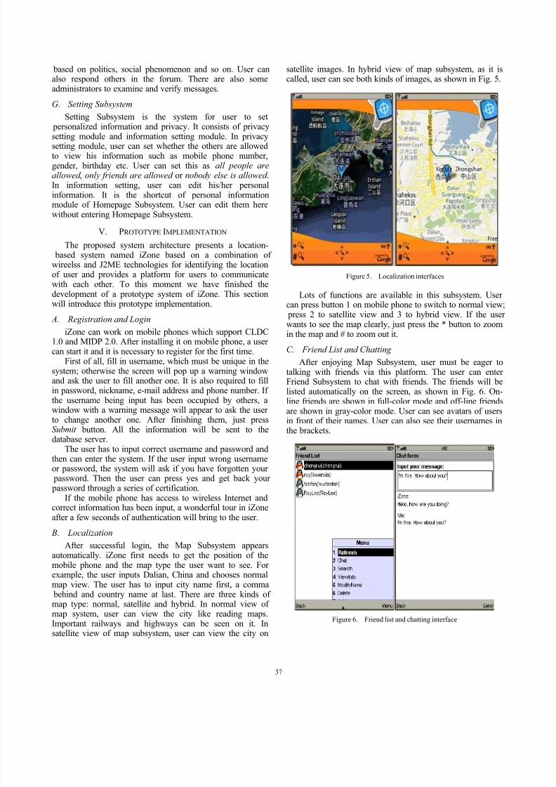
B. Localization
After successful login, the Map Subsystem appearsautomatically. iZone first needs to get the position of themobile phone and the map type the user want to see. For example, the user inputs Dalian, China and chooses normalmap view. The user has to input city name first, a comma behind and country name at last. There are three kinds of map type: normal, satellite and hybrid. In normal view of map system, user can view the city like reading maps.Important railways and highways can be seen on it. Insatellite view of map subsystem, user can view the city on
satellite images. In hybrid view of map subsystem, as it iscalled, user can see both kinds of images, as shown in Fig. 5.
Figure 5. Localization interfaces
Lots of functions are available in this subsystem. User can press button 1 on mobile phone to switch to normal view; press 2 to satellite view and 3 to hybrid view. If the user wants to see the map clearly, just press the * button to zoomin the map and # to zoom out it.
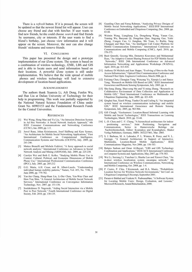
C. Friend List and Chatting
After enjoying Map Subsystem, user must be eager totalking with friends via this platform. The user can enter Friend Subsystem to chat with friends. The friends will belisted automatically on the screen, as shown in Fig. 6. On-line friends are shown in full-color mode and off-line friends
are shown in gray-color mode. User can see avatars of usersin front of their names. User can also see their usernames inthe brackets.
Figure 6. Friend list and chatting interface
37
8/2/2019 OK - MOBILE - iZone a Location-Based Mobile Social Networking System
http://slidepdf.com/reader/full/ok-mobile-izone-a-location-based-mobile-social-networking-system 6/6
There is a refresh button. If it is pressed, the screen will be updated so that the newest friend list will appear. User canchoose any friend and chat with him/her. If user wants tofind new friends, he/she could choose search and find friends by username, city or interests. If the user wants to find afriend’s birthday, just choose view information and it willappear on the screen. Moreover, the user can also change
friends’ nickname and remove friends.
VI. CONCLUSIONS
This paper has presented the design and a prototypeimplementation of our iZone system. The system is based ona combination of wireless technology, J2ME, LBS and GISand is able to locate users and send information based ontheir locations. A powerful iZone system is still under implementation. We believe that the wide spread of mobile phones and wireless technology will lead to extensivedevelopment of location-based applications.
ACKNOWLEDGMENT
The authors thank Xuanxia Li, Aili Dong, Fenfen Wu,
and Han Liu at Dalian University of Technology for their help in programming. This work was partially supported bythe National Natural Science Foundation of China under Grant No. 60903153 and the Fundamental Research Fundsfor the Central Universities.
R EFERENCES
[1] Wei Wang, Hong Man and Yu Liu, “An Intrusion Detection Systemin Ad Hoc Networks: A Social Network Analysis Approach,” 6thIEEE Consumer Communications and Networking Conference(CCNC), Jan. 2009, pp. 1-5.
[2] Juwel Rana, Johan Kristiansson, Josef Hallberg and Kare Synnes,“An Architecture for Mobile Social Networking Applications,” FirstInternational Conference on Computational Intelligence,Communication Systems and Networks (CICSYN), July. 2009, pp.
241-246.[3] Matteo Brunelli and Michele Fedrizzi, “A fuzzy approach to social
network analysis,” International Conference on Advances in Social Network Analysis and Mining (ASONAM), July. 2009, pp. 225-230.
[4] Carolyn Wei and Beth E. Kolko, “Studying Mobile Phone Use inContext: Cultural, Political, and Economic Dimensions of MobilePhone Use,” International Professional Communication Conference(IPCC), July. 2005, pp. 205-212
[5] G.G. Marta, A.H. Cesar, and B. Albert-Laszlo, “Understandingindividual human mobility patterns,” Nature, Vol. 453, No. 7196, 5June 2008, pp. 779-782.
[6] Yao-Jen Chang, Hung-Huan Liu, Li-Der Chou, Yen-Wen Chen andHaw-Yun Shin, “A General Architecture of Mobile Social Network Services,” International Conference on Convergence InformationTechnology, Nov. 2007, pp. 151-156.
[7] Soulakshmee D. Nagowah, “Aiding Social Interaction via a Mobile
Peer to Peer Network,” Fourth International Conference on DigitalSociety, Feb. 2010, pp. 130-135.
[8] Guanling Chen and Faruq Rahman, “Analyzing Privacy Designs of Mobile Social Networking Applications,” IEEE/IFIP InternationalConference on Embedded and Ubiquitous Computing, Dec. 2008, pp.83-88.
[9] Weimin Wang, Liangliang Liu, Dongsheng Wang, Yanan Cao,Yuming Wu, Baoyuan Qi, Dongchun Qiao, Jingyang Guo, YufeiZheng, Cungen Cao, Li Jianghua, Shi Yuan, Li Ruilin, SangChangqin and Shen Nan, “An Intelligent Call Center Platform for
Mobile Communication Enterprises,” International Conference onCommunications and Mobile Computing (CMC), April. 2010, pp.370-375.
[10] Basit Qureshi, Geyong Min, Demetres Kouvatsos and MohammadIlyas, “An Adaptive Content Sharing Protocol for P2P Mobile Social
Networks,” IEEE 24th International Conference on AdvancedInformation Networking and Applications Workshops (WAINA),April. 2010, pp. 413-418.
[11] Anthony Di Michele and Jean Huppe, “Evolving a Fibre-to-the-NodeAccess Infrastructure,” Optical Fiber Communication Conference and
National Fiber Optic Engineers Conference, March.2006, pp. 6.
[12] Feixiang Chen, Chongjun Yang, Wenyang Yu, Xiaoqiu Le and JianyuYang, “Research on Mobile GIS Based on LBS,” IEEE InternationalGeoscience and Remote Sensing Symposium, July. 2005, pp. 4.
[13] Shu-liang Zhang, Shao-song Ma and Yi-ming Zhang, “Research onCollaborative Environment of Data Collection and Application in
Mobile GIS,” Third International Conference on Multimedia andUbiquitous Engineering, June. 2009, pp. 421-428.
[14] Qinghui Sun, Xiaoli Wang, Tianhe Chi and Cuiling Ji, “An integratedsystem based on wireless communication technology and mobileGIS,” IEEE International Geoscience and Remote SensingSymposium, July. 2005, pp. 963-966.
[15] Gill Clough, “Geolearners: Location-Based Informal Learning withMobile and Social Technologies,” IEEE Transactions on LearningTechnologies, March. 2010, pp. 33-44.
[16] L.-D. Chou and C.-Y. Chang, "A hierarchical architecture for indoor positioning services," Joint Positioning, Navigation andCommunication, Series in Hannoversche Beiträge zur
Nachrichtentechnik, Editor: Kyamakya and Kyandoghere, Shaker Verlag Publishers, Germany, ISBN: 3832237461, Mar. 2005.
[17] S. J. Barbeau, M. A. Labrador, P. L. Winters, R. Perez, and N. L.Georggi, “A General Architecture in Support of Interactive,
Multimedia, Location-Based Mobile Applications,” IEEECommunications Magazine, Nov.2006, pp. 156-163.
[18] Balqies Sadoun and Omar Al-Bayari, “LBS and GIS TechnologyCombination and Applications,” IEEE/ACS International Conferenceon Computer Systems and Applications, May.2007, pp. 578-583.
[19] Wei Li, Suxiang Li, Yunchun Li, Shasha Luo and Xinwei Chen, “Anin-door wireless localization system oncampus network,” 4thInternational Conference on Wireless Communications, Networkingand Mobile Computing, Oct. 2008, pp. 1-4.
[20] P. Castro, P. Chiu, T.Kremenek, and R.A. Muntz, “ProbabilisticLocation Service for Wireless Network Environments,” Int Conf. onUbiquitous Computing (Ubicomp), September 2001.
[21] Paramvir Bahlnd and Venkata N. Padmanabhan, “A Software Systemfor Locating Mobile Users: Design, Evaluation, and Lessons,”Microsoft Research, Anand Balachandran, 2000.
38