Embed Size (px)
Citation preview

OFFSHORE OIL & GAS LICENSING 31
ST SEAWARD
ROUND Habitats Regulations Assessment
Appropriate Assessment: Irish Sea
April 2019

© Crown copyright 2019
This publication is licensed under the terms of the Open Government Licence v3.0
except where otherwise stated.
To view this licence, visit nationalarchives.gov.uk/doc/open-government-
licence/version/3 or write to the Information Policy Team, The National Archives, Kew,
London TW9 4DU, or email: [email protected].
Any enquiries regarding this publication should be sent to us at [email protected].

Potential Award of Blocks in the 31st Seaward Licensing Round: Appropriate Assessment
Contents
1 Introduction _______________________________________________________ 1
1.1 Background and purpose _________________________________________ 1
1.2 Relevant Blocks ________________________________________________ 2
1.3 Relevant Natura 2000 sites ________________________________________ 3
1.4 Assessment overview ____________________________________________ 5
2 Licensing and potential activities _______________________________________ 7
2.1 Licensing ______________________________________________________ 7
2.2 Activities that could follow licensing _________________________________ 8
2.3 Existing regulatory requirements and controls _________________________ 20
3 Appropriate assessment process ______________________________________ 22
3.1 Process _______________________________________________________ 22
3.2 Site integrity ___________________________________________________ 22
3.3 Assessment of effects on site integrity _______________________________ 23
4 Evidence base for assessment ________________________________________ 24
4.1 Introduction ____________________________________________________ 24
4.2 Physical disturbance and drilling effects ______________________________ 25
4.3 Underwater noise effects _________________________________________ 31
5 Assessment ______________________________________________________ 40
5.1 Relevant sites __________________________________________________ 40
5.2 Assessment of physical disturbance and drilling effects __________________ 47
5.3 Assessment of underwater noise effects ______________________________ 62
5.4 In-combination effects ____________________________________________ 73
6 Overall conclusion __________________________________________________ 86
7 References _______________________________________________________ 86

Potential Award of Blocks in the 31st Seaward Licensing Round: Appropriate Assessment
1
1 Introduction
1.1 Background and purpose
The plan/programme covering this and potential future seaward licensing rounds has been
subject to a Strategic Environmental Assessment (OESEA3), completed in July 2016. The
SEA Environmental Report includes detailed consideration of the status of the natural
environment and potential effects of the range of activities which could follow licensing,
including potential effects on conservation sites. The SEA Environmental Report was subject
to an 8-week public consultation period, and a post-consultation report summarising comments
and factual responses was produced as an input to the decision to adopt the plan/programme.
This decision has allowed the Oil & Gas Authority (OGA) to progress with further seaward oil
and gas licensing rounds. As a result, on 10th July 2018, the OGA invited applications for
licences relating to 1,779 Blocks in a 31st Seaward Licensing Round covering mature and
frontier areas of the UK Continental Shelf (UKCS). Applications were received for licences
covering 164 Blocks/part Blocks.
The Offshore Petroleum Activities (Conservation of Habitats) Regulations 2001 (as amended)
implement the requirements of Articles 6(3) and 6(4) of the Habitats Directive with respect to oil
and gas activities in UK territorial waters and on the UK Continental Shelf. The Conservation
of Offshore Marine Habitats and Species Regulations 2017 cover other relevant activities in
offshore waters (i.e. excluding territorial waters). Within territorial waters, the Habitats
Directive is transposed into UK law via the Conservation of Habitats and Species Regulations
2017 in England and Wales, the Conservation (Natural Habitats, &c.) Regulations 1994 in
Scotland (for non-reserved matters), and the Conservation (Natural Habitats, &c) Regulations
(Northern Ireland) 1995 (as amended) in Northern Ireland.
As the petroleum licensing aspects of the plan/programme are not directly connected with or
necessary for nature conservation management of European (Natura 20001) sites, to comply
with its obligations under the relevant regulations, the Department for Business, Energy and
Industrial Strategy2 (BEIS) is undertaking a Habitats Regulations Assessment (HRA). To
comply with obligations under the Offshore Petroleum Activities (Conservation of Habitats)
Regulations 2001 (as amended), in winter 2018, the Secretary of State undertook a screening
assessment to determine whether the award of any of the Blocks offered would be likely to
1 This includes Special Areas of Conservation (SAC) and Special Protection Areas (SPA), and potential sites for
which there is adequate information on which to base an assessment. 2 Note that while certain licensing and regulatory functions were passed to the OGA (a government company
wholly owned by the Secretary of State for BEIS) on 1 October 2016, environmental regulatory functions are retained by BEIS, and are administered by the Offshore Petroleum Regulator for Environment and Decommissioning (OPRED).

Potential Award of Blocks in the 31st Seaward Licensing Round: Appropriate Assessment
2
have a significant effect on a relevant site, either individually or in combination3 with other
plans or projects (BEIS 2018a). In doing so, BEIS has applied the Habitats Directive test4
(elucidated by the European Court of Justice in the case of Waddenzee (Case C-127/02)5)
which is:
…any plan or project not directly connected with or necessary to the management of the
site is to be subject to an appropriate assessment of its implications for the site in view
of the site's conservation objectives if it cannot be excluded, on the basis of objective
information, that it will have a significant effect on that site, either individually or in
combination with other plans or projects.
…where a plan or project not directly connected with or necessary to the management
of a site is likely to undermine the site’s conservation objectives, it must be considered
likely to have a significant effect on that site. The assessment of that risk must be made
in the light inter alia of the characteristics and specific environmental conditions of the
site concerned by such a plan or project.
1.2 Relevant Blocks
The screening assessment (including consultation with the statutory conservation
agencies/bodies) formed the first stage of the HRA process. The assessment was undertaken
in the period within which applications for Blocks were being accepted, and therefore
considered all 1,779 Blocks offered. The screening identified 525 whole or part Blocks as
requiring further assessment prior to decisions on whether to grant licences (BEIS 2018a).
Following the closing date for 31st Seaward Round applications, and the publication of the
screening document, those Blocks identified as requiring further assessment were
reconsidered against the list of actual applications. It was concluded that further assessment
(Appropriate Assessment, AA) was required for 41 of the Blocks applied for. Because of the
wide distribution of these Blocks around the UKCS, the AAs are documented in four regional
reports as follows:
Mid North Sea High
Moray Firth
Irish Sea
3 Note that “in-combination” and “cumulative” effects have similar meanings, but for the purposes of HRA, and in
keeping with the wording of Article 6(3) of the Habitats Directive, “in-combination” is used to describe the potential for such effects throughout. More information on the definitions of “cumulative” and “in-combination” effects are available in MMO (2014) and Judd et al. (2015). 4 See Article 6(3) of the Habitats Directive.
5 Also see the Advocate General’s Opinion in the recent ‘Sweetman’ case (Case C-258/11), which confirms those
principles set out in the Waddenzee judgement.

Potential Award of Blocks in the 31st Seaward Licensing Round: Appropriate Assessment
3
English Channel
1.2.1 Irish Sea Blocks
The Irish Sea Blocks applied for in the 31st Round and considered in this assessment are listed
below in Table 1.1, and are shown in Figure 1.1.
Table 1.1: Blocks requiring further assessment
109/10 109/15 110/1 110/4 110/6
110/7b 110/8b 110/9c 110/11 110/12c
113/22
1.3 Relevant Natura 2000 sites
The screening identified the relevant Natura 2000 sites and related Blocks requiring further
assessment in the Irish Sea (refer to Appendix B of BEIS 2018a). Following a reconsideration
of those Blocks and sites screened in against those Blocks applied for, 12 Natura 2000 sites
were identified as requiring further assessment in relation to 11 Blocks (Table 1.2 and Figure
1.1). Abbreviations and species common names follow those in Appendix A of BEIS (2018a).
Table 1.2: Relevant sites requiring further assessment
Relevant site Features
Relevant Blocks applied for
Potential effects
Special Protection Areas (SPAs)
Morecambe Bay and Duddon Estuary SPA Breeding: common tern, sandwich tern, little tern Over winter: whooper swan, little egret, golden plover, ruff, bar-tailed godwit, Mediterranean gull, lesser black-backed gull, herring gull; On passage: pink-footed goose, shelduck, oystercatcher, ringed plover, grey plover, knot, sanderling, dunlin, black-tailed godwit, curlew, pintail, turnstone, redshank, lesser black-backed gull. Seabird and waterbird assemblage all year round
110/4, 110/9c, 113/22 Underwater noise
110/4, 113/22 Physical disturbance and drilling
Ribble and Alt Estuaries SPA Breeding: common tern, ruff On passage: ringed plover, sanderling, redshank, whimbrel; Over winter: bar-tailed godwit, Bewick's swan, golden plover, whooper swan, lesser black-backed gull, black-headed gull pintail, teal, wigeon, pink-footed goose, scaup, sanderling, dunlin, knot, oystercatcher, black-tailed godwit, common scoter, curlew, cormorant, grey plover, shelduck, redshank, lapwing. Breeding seabird and overwintering waterbird assemblages
110/4, 110/9c Underwater noise
110/9c Physical disturbance and drilling
Liverpool Bay SPA Breeding: little tern, common tern Over winter: red-throated diver, little gull,
109/15, 110/1, 110/4, 110/6, 110/7b, 110/8b, 110/9c, 110/11, 110/12c
Underwater noise

Potential Award of Blocks in the 31st Seaward Licensing Round: Appropriate Assessment
4
Relevant site Features
Relevant Blocks applied for
Potential effects
common scoter Wintering waterbird assemblage
109/15, 110/4, 110/7b, 110/8b, 110/9c, 110/11, 110/12c
Physical disturbance and drilling
Mersey Narrows and North Wirral Foreshore SPA Breeding: common tern On passage: little gull, common tern Over winter: bar-tailed godwit, knot Wintering waterbird assemblage
109/15, 110/4, 110/7b, 110/8b, 110/9c, 110/11, 110/12c
Physical disturbance and drilling
The Dee Estuary SPA Breeding: common tern, little tern On passage: Sandwich tern, redshank Over winter: bar-tailed godwit, pintail, teal, dunlin, knot, oystercatcher, black-tailed godwit, curlew, grey plover, shelduck, redshank Wintering waterbird assemblage
109/15, 110/4, 110/7b, 110/8b, 110/9c, 110/11, 110/12c
Physical disturbance and drilling
Anglesey Terns / Morwenoliaid Ynys Môn SPA Breeding: roseate tern, common tern, Arctic tern, Sandwich tern
109/15 Physical disturbance and drilling
Special Areas of Conservation (SACs)
Drigg Coast SAC Annex I habitat: estuaries, coastal dunes, mudflats and sandflats, saltmarsh and salt meadows, coastal dunes
113/22 Physical disturbance and drilling
Morecambe Bay SAC Annex I habitat: estuaries, mudflats and sandflats, inlets and bays, vegetation of stony banks, saltmarsh and salt meadows, coastal dunes, sandbanks, coastal lagoons, reefs, coastal dunes
110/4 Physical disturbance and drilling
Shell Flat and Lune Deep SAC Annex I habitat: reefs
110/4, 110/8b, 110/9c Physical disturbance and drilling
North Anglesey Marine / Gogledd Môn Forol SAC Annex II species: harbour porpoise
109/10, 109/15 Underwater noise
109/15 Physical disturbance and drilling
Pen Llyn a`r Sarnau/ Lleyn Peninsula and the Sarnau SAC Annex I habitats: sandbanks, estuaries, coastal lagoons, inlets and bays, reefs, mudflats and sandflats, saltmarsh and salt meadows, sea caves Annex II species: bottlenose dolphin, otter, grey seal
109/15 Underwater noise
Cardigan Bay/ Bae Ceredigion SAC Annex I habitats: sandbanks, reefs, sea caves Annex II species: sea lamprey, river lamprey, grey seal, bottlenose dolphin
109/15 Underwater noise

Potential Award of Blocks in the 31st Seaward Licensing Round: Appropriate Assessment
5
1.4 Assessment overview
This document sets out the key assumptions and approach to the AA, the evidence base
underpinning the assessment and the assessment of relevant Blocks and sites. The document
is organised as follows:
Overview of the licensing process and nature of the activities that could follow including
assumptions used to underpin the AA process (Section 2)
Description of the approach to ascertaining the absence or otherwise of adverse effects
on the integrity of relevant European sites (Section 3)
Evidence base on the environmental effects of offshore oil and gas activities to inform the
assessment (Section 4)
The assessment of effects on the integrity of relevant sites, including in-combination with
other plans or projects (Sections 5-8)
Overall conclusion (Section 9)
As part of this HRA process, the AA document is being subject to consultation with appropriate
nature conservation bodies and the public and will be amended as appropriate in light of
comments received. The final AA document will be available via the 31st Round Appropriate
Assessment webpage of the gov.uk website.

Potential Award of Blocks in the 31st Seaward Licensing Round: Appropriate Assessment
6
Figure 1.1: Blocks and sites relevant to this Appropriate Assessment

Potential Award of Blocks in the 31st Seaward Licensing Round: Appropriate Assessment
7
2 Licensing and potential activities
2.1 Licensing
The exclusive rights to search and bore for petroleum in Great Britain, the territorial sea
adjacent to the United Kingdom and on the UKCS are vested in the Crown and the Petroleum
Act 1998 (as amended) gives the OGA the power to award Seaward Production Licences
which grant exclusive rights to the holders “to search and bore for, and get, petroleum” in the
area covered by the Licence. A Seaward Production Licence does not constitute any form of
approval for activities to take place in the licensed Blocks, nor does it confer any exemption
from other legal or regulatory requirements. Offshore activities that may follow licensing are
subject to a range of statutory permitting and consenting requirements, including, where
relevant, activity specific AA as required under Article 6(3) of the Habitats Directive (Directive
92/43/EC).
Several sub-types of Seaward Production Licence were available in previous rounds
(Traditional, Frontier and Promote) which have been replaced by the single “Innovate” licence6.
As per previous licensing structures, the Innovate licence is made up of three terms covering
exploration (Initial Term), appraisal and field development planning (Second Term), and
development and production (Third Term). The lengths of the first two terms are flexible but
have a maximum duration of 9 and 6 years respectively. The Third Term is granted for 18
years but may be extended if production continues beyond this period. The Innovate licence
introduces three Phases to the Initial Term, covering:
Phase A: geotechnical studies and geophysical data reprocessing (note that the
acquisition of new seismic could take place in this phase for the purpose of defining a 3D
survey as part of Phase B, but normally this phase will not involve activities in the field)
Phase B: shooting of new seismic and other geophysical data
Phase C: exploration and appraisal drilling
Applicants may propose the Phase combination in their submission to the OGA. Phase A and
Phase B are optional and may not be appropriate in certain circumstances, but every
application must propose a Phase C, except where the applicant does not think any
exploration is needed (e.g. in the development of an existing discovery or field re-development)
and proposes to go straight to development (i.e. ‘straight to Second Term’). The duration of
the Initial Term and the Phases within it are agreed between the OGA and the applicant.
Applicants may choose to spend up to 4 years on a single Phase in the Initial Term but cannot
6 The Petroleum and Offshore Gas Storage and Unloading Licensing (Amendment) Regulations 2017 amend the
Model Clauses to be incorporated in Seaward Production Licences so as to implement the Innovate licences to be issued in the 31
st Round.

Potential Award of Blocks in the 31st Seaward Licensing Round: Appropriate Assessment
8
take more than 9 years to progress to the Second Term. Failure to complete the work agreed
in a Phase, or to commit to the next Phase means the licence ceases, unless the term has
been extended by the OGA.
Financial viability is considered prior to licence award for applicants proposing to start at Phase
A or B, but further technical and financial capacity for Phase C activities would need to be
demonstrated before the licence could enter Phase C and drilling could commence. If the
applicant proposes to start the licence at Phase C or go straight to the Second Term, the
applicant must demonstrate that it has the technical competence to carry out the activities that
would be permitted under the licence during that term, and the financial capacity to complete
the work programme, before the licence is granted. It is noted that the safety and
environmental capability and track record of all applicants are considered by the OGA (in
consultation with the Offshore Safety Directive Regulator)7 through written submissions before
licences are awarded8.
As part of these written submissions operators must demonstrate that they have the relevant
safety and environmental capabilities to undertake the proposed work programme (e.g.
company environmental policies, awareness of statutory safety and environment provisions,
and has environmental management systems). Where full details cannot be provided in the
written submissions at the application stage, licensees must provide supplementary
submissions that address any outstanding environmental and safety requirements before
approvals for specific offshore activities such as drilling can be issued. In all instances
applicants must submit an environmental sensitivities assessment, demonstrating at the
licence application stage that they are aware of environmental sensitivities relevant to the
Blocks being applied for and the adjacent areas, and understand the potential impacts of the
proposed work programme.
2.2 Activities that could follow licensing
As part of the licence application process, applicants provide the OGA with details of work
programmes they propose in the Initial Term. These work programmes are considered along
with a range of other factors by the OGA before arriving at a decision on whether to license the
Blocks and to whom. Activities detailed in work programmes may include the purchase,
reprocessing or shooting of 2D or 3D seismic data (Phases A and B) and the drilling of wells
(Phase C). There are three levels of drilling commitment:
A Firm Drilling Commitment is a commitment to the OGA to drill a well. Firm drilling
commitments are preferred on the basis that, if there were no such commitment, the OGA
7 The Offshore Safety Directive Regulator is the Competent Authority for the purposes of the Offshore Safety
Directive comprising of the Department for Business, Energy and Industrial Strategy (BEIS) Offshore Petroleum Regulator for Gas Environment and Decommissioning (OPRED) and the Health and Safety Executive (HSE) working in partnership. 8 Refer to OGA technical guidance and safety and environmental guidance (Appendix C) on applications for the
31st Round at: https://www.ogauthority.co.uk/licensing-consents/licensing-rounds/

Potential Award of Blocks in the 31st Seaward Licensing Round: Appropriate Assessment
9
could not be certain that potential licensees would make full use of their licences.
However, the fact that a licensee has been awarded a licence on the basis of a “firm
commitment” to undertake a specific activity should not be taken as meaning that the
licensee will actually be able to carry out that activity. This will depend upon the outcome
of relevant activity specific environmental assessments.
A Contingent Drilling Commitment is also a commitment to the OGA to drill a well, but it
includes specific provision for the OGA to waive the commitment in light of further
technical information.
A Drill or Drop (D/D) Drilling Commitment is a conditional commitment with the proviso
that the licence is relinquished if a well is not drilled.
Note that Drill or Drop and Contingent work programmes (subject to further studies by the
licensees) will probably result in a well being drilled in less than 50% of the cases.
The OGA general guidance9 makes it clear that an award of a Production Licence does not
automatically allow a licensee to carry out any offshore petroleum-related activities from then
on (this includes those activities outlined in initial work programmes, particularly Phases B and
C). Figure 2.1 provides an overview of the plan process associated with the 31st Seaward
Licensing Round and the various environmental assessments including HRA. Offshore
activities such as drilling and seismic survey are subject to relevant activity specific
environmental assessments by BEIS (see Figures 2.2 and 2.3), and there are other regulatory
provisions exercised by the Offshore Safety Directive Regulator and bodies such as the Health
and Safety Executive. It is the licensee’s responsibility to be aware of, and comply with, all
regulatory controls and legal requirements, and work offshore cannot proceed until the relevant
consents/approvals are in place.
The proposed work programmes for the Initial Term are detailed in the licence applications.
For some activities, such as seismic survey, the potential impacts associated with noise could
occur some distance from the licensed Blocks and the degree of activity is not necessarily
proportional to the size or number of Blocks in an area. In the case of direct physical
disturbance, the Blocks being applied for are relevant.
9 https://www.ogauthority.co.uk/media/4950/general-guidance-31st-seaward-licensing-round-july-2018.docx

Potential Award of Blocks in the 31st Seaward Licensing Round: Appropriate Assessment
10
Figure 2.1: Stages of plan level environmental assessment
Consultation with SNCBs on scope and content of screening document
Plan/programme subject to Strategic Environmental
Assessment (note 2)
Announcement of seaward licensing Round. Operators
invited to bid for blocks released across the UKCS
Early SNCB & stakeholder input (informal & formal scoping, expert & stakeholder workshops, Steering Group).
SEA subject to formal public consultation.Research/studies to address data gaps and SEA
recommendations
Licence applicants must provide a safety and environmental
capability submission and a high level environmental sensitivities
assessment for Blocks applied for
OGA release licensing Round information pack including application guidance and list of "other regulatory issues" to support licence applicant's submission. Spatial information
representing existing offshore activities also released.
HRA screening undertakenfor all blocks offered and
screening report published
Likely Significant Effects identified for relevant sites in
relation to certain Blocks offered
No
Yes
Relevant Blocks applied for subject to Appropriate
Assessment and draft report published
Consultation with SNCBs, the public and other member states where relevant
Appropriate Assessments amended based on
consultation feedback and final reports published
Blocks licensed where no adverse effect on site integrity
predicted (subject to other conditions and obligations –
see project level requirements)
Activities in all Blocks subject to project specific controls(see Figures 2.3 and 2.4)
Publication of post consultation report
Adoption of plan/programme &post adoption statement
Note 1: A summary of Regulatory controls are provided in Appendix 3 of DECC (2016), OESEA3
Note 2: More than 1 licensing round may be covered by a single SEA if the geographical or technical scope of the plan/programme is unchanged, and the environmental information and context on which the SEA is based has not appreciably changed. BEIS undertook a review of OESEA3 in 2018 and concluded that new information and updates published since OESEA3 have not significantly changed the policy and technology context of the plan, or the environmental baseline and understanding of effects underpinning its assessment.
Environmental submissions/consultations/
other relevant inputs
Stages of plan/programme level assessment
Habitats Regulations Assessment (HRA) stages
Licensing decisions
Key
Current stage of the HRA process
Announcement of a plan/programme to enable
future licensing for oil & gas for blocks on the UKCS
(note 1)
Blocks released for licensing if applied
for

Potential Award of Blocks in the 31st Seaward Licensing Round: Appropriate Assessment
11
Figure 2.2: High level overview of exploration drilling environmental requirements
Drilling of a well is proposed within a licensed Block
It is considered by BEIS that the activities are likely to have
a significant effect on a European site
Full ES undertaken for activities associated with
drilling. All activities subject to further permitting.
Consultation with SNCBs and the
public.
A Direction is sought that an ES is not required through a
Drilling Operations Application. SoS decision on whether an
ES is required (note 2)
Environmental submissions/consultations/
other relevant inputs
Stages of project permitting
Habitats Regulations Assessment (HRA) stages
Permitting/Consenting decisions
Note 1: See BEIS (2018). The Offshore Petroleum Production and Pipelines (Assessment of Environmental Effects) Regulations 1999 (as amended) –A Guide. The Offshore Petroleum Regulator for Environment and Decommissioning, 80pp.
Note 2: Early consultation between BEIS and licensed operators is typical to mitigate against Environmental Statement (ES) requirements being identified following the request for a direction
Note 3: In cases where an ES was initially identified as not required, or where an ES has been approved, the requirement to undertake AA may still apply (e.g. due to changes in the nature of the project or the designation of additional European sites)
* Article 6(4) of the Habitats Directive provides a derogation which would allow a plan or project to be approved in limited circumstances even though it would or may have an adverse effect on the integrity of a European site (see: Defra 2012).
Yes
BEIS strongly recommend operators early consultation with SNCBs on proposed activities (e.g. scoping).
28 day public consultation period.Statutory consultees include SNCBs and other
stakeholders (e.g. MCA)
No
YesBEIS undertake Appropriate
Assessment before a decisioncan be taken
Conclusion of no adverse effect on site integrity?Yes
Well consent cannot be granted*
Options appraisal/selection
must consider environmental implications
Well consent can be granted subject to all regulatory and other requirements having been met as part of a Drilling Operations Application (e.g. requirement to have in place an approved Oil Pollution Emergency Plan, permit for chemical use and discharge, consent to locate within the UKCS). These
permits/consents/approvals are subject to other regulatory controls and are reviewed by the regulator and its advisors prior to any consent being granted.Also see note 3
Key
No
NoYes
The nature or location of drilling related activities leads
to the mandatory submission of a full Environmental Statement
(ES) (note 1)
No

Potential Award of Blocks in the 31st Seaward Licensing Round: Appropriate Assessment
12
Figure 2.3: High level overview of seismic survey environmental requirements
Consultation with SNCBs
Geological survey (e.g. 2D, 3D seismic, VSP) is proposed within a
licensed Block
Location and sound source size such that an Environmental Impact
Assessment and noise assessmentare required in support of a Marine
Survey application
It is considered that the activities are likely to have a significant effect on a
European site
BEIS undertake Appropriate Assessment before a decision
can be takenYes
Consent cannot be granted*
No
No
Survey planning(e.g. cetacean sensitivity of the
proposed area, periods of concern for seismic)
Consent to undertake a marine survey granted subject to conditions (note 1)
Apply for Marine Survey Consent
Conclusion of no adverse effect on site integrity?
Yes
Early consultation with SNCBs and BEIS
Habitats Regulations Assessment (HRA) stages
Permitting/Consenting decisions
Stages of project permitting
Environmental submissions/consultations/
other relevant inputs
Key
Consultation with SNCBs
Note 1: As part of consent condition, operators would be required to follow the JNCC guidelines for minimising the risk of injury to marine mammals from geophysical surveys (JNCC 2017).
Condition of consent that Seismic Survey Closeout Report completed (may include submission of Marine Mammal Observer and Passive Acoustic Monitoring reports)
* Article 6(4) of the Habitats Directive provides a derogation which would allow a plan or project to be approved in limited circumstances even though it would or may have an adverse effect on the integrity of a European site (see: Defra 2012).

Potential Award of Blocks in the 31st Seaward Licensing Round: Appropriate Assessment
13
2.2.1 Likely scale of activity
On past experience the activity that actually takes place is less than what is included in the
work programmes at the licence application stage. A proportion of Blocks awarded may be
relinquished without any offshore activities occurring. Activity after the Initial Term is much
harder to predict, as this depends on the results of the initial phase, which is, by definition,
exploratory. Typically, less than half the wells drilled reveal hydrocarbons, and of that, less
than half will have a potential to progress to development. For example, the OGA analysis of
exploration well outcomes from the Moray Firth & Central North Sea between 2003 and 2013
indicated an overall technical success rate of 40% with respect to 150 exploration wells and
side-tracks (Mathieu 2015). Depending on the expected size of finds, there may be further
drilling to appraise the hydrocarbons (appraisal wells). For context, Figure 2.4 highlights the
total number of exploration and appraisal wells started on the UKCS each year since 2000 as
well as the number of significant discoveries made (associated with exploration activities).
Discoveries that progress to development may require further drilling, installation of
infrastructure such as wellheads, pipelines and possibly fixed platform production facilities,
although recent developments are mostly tiebacks to existing production facilities rather than
stand-alone developments. For example, of the 33 relevant projects identified by the OGA’s
Project Pathfinder (as of 5th April 2019)10, 18 are planned as subsea tie-backs to existing
infrastructure, 6 involve new stand-alone production platforms and 5 are likely to be developed
via Floating Production, Storage and Offloading facilities (FPSO). The final form of
development for many of the remaining projects is not decided, with some undergoing re-
evaluation of development options but some are likely to be subsea tie-backs. Figure 2.4
indicates that the number of development wells has declined over time and this pattern is likely
to continue. The nature and scale of potential environmental impacts from the drilling of
development wells are similar to those of exploration and appraisal wells and thus the
screening criteria described in Section 4 are applicable to the potential effects of development
well drilling within any of the 31st Round Blocks.
10
https://itportal.ogauthority.co.uk/eng/fox/path/PATH_REPORTS/pdf

Potential Award of Blocks in the 31st Seaward Licensing Round: Appropriate Assessment
14
Figure 2.4: UKCS Exploration, appraisal & development wells, and significant
discoveries since 2000
Note: "significant" generally refers to the flow rates that were achieved (or would have been reached) in well tests (15 mmcfgd or 1000 BOPD) and does not indicate commercial potential of the discovery. Source: OGA Drilling Activity (February 2019), Significant Offshore Discoveries (October 2018)
2.2.2 31st Round activities considered by the HRA
The nature, extent and timescale of development, if any, which may ultimately result from the
licensing of 31st Round Blocks is uncertain, and therefore it is regarded that at this stage a
meaningful assessment of development level activity (e.g. pipelay, placement of jackets,
subsea templates or floating installations) cannot be made. Once project plans are in place,
subsequent permitting processes relating to exploration, development and decommissioning,
would require assessment including an HRA where appropriate, allowing the opportunity for
further mitigation measures to be identified as necessary, and for permits to be refused if
necessary. In this way the opinion of the Advocate General in ECJ (European Court of
Justice) case C-6/04, on the effects on Natura sites, "must be assessed at every relevant stage
of the procedure to the extent possible on the basis of the precision of the plan. This
assessment is to be updated with increasing specificity in subsequent stages of the procedure"
is addressed. Therefore, only activities as part of the work programmes associated with the
Initial Term and its associated Phases A-C will be considered in this AA (see Table 2.2).
Potential accidental events, including spills, are not considered in the AA as they are not part
of the work plan. Measures to prevent accidental events, response plans and potential
impacts in the receiving environment would be considered as part of the environmental impact
0
50
100
150
200
250
300
350
Num
ber
of
wells
sta
rted a
nd s
ignifi
cant dis
cove
ries
Discoveries
Exploration wells
Appraisal wells
Development wells

Potential Award of Blocks in the 31st Seaward Licensing Round: Appropriate Assessment
15
assessment (EIA) process for specific projects that could follow licensing when the location,
nature and timing of the proposed activities are available to inform a meaningful assessment of
such risks. The EIA would be informed the modelling undertaken for the Oil Pollution
Emergency Plan (OPEP). The OPEP is assessed by BEIS, and a range of organisations, and
other Government departments are consulted by BEIS during the OPEP determination
process. The OPEP includes an assessment of spill risk, response arrangements, and details
of actions, interfaces, training and exercises specific to an installation or operation11. A
comprehensive overview of spill risk on the UKCS from offshore oil & gas activity and related
potential environmental effects is provided in OESEA3 (DECC 2016). It should be noted that
prospectivity in the Irish Sea is primarily for gas, though some oil is produced to the south of
the basin (e.g. as associated with the Lennox, Conwy and Douglas fields).
The approach used in this assessment has been to take the proposed activity for the Block as
being the maximum of any application for that Block, and to assume that all activity takes
place. The estimates of work commitments for the relevant Blocks from the applications
received by the OGA are shown in Table 2.1. It is noted that none of the indicative work
programmes for the Irish Sea region include the option to conduct 3D seismic survey and,
therefore, potential underwater noise effects are restricted to those associated with drilling and
well evaluation (e.g. site survey, vertical seismic profiling, rig and vessel movement, possible
conductor piling). Additionally, the number of wells presented represents a worst-case
scenario since several Blocks may be included in one licence and the drill or drop
well/contingent well applies to the licence, i.e. it is likely that fewer wells will be drilled than
indicated in Table 2.1.
Table 2.1: Indicative work programmes relevant to Blocks considered in this
assessment
Relevant Blocks Obtain
12 and/or reprocess
2D or 3D seismic data Shoot 3D seismic
Drill or drop well/contingent well
109/10 - -
109/15 - -
110/1 - -
110/4 - -
110/6 - -
110/11 - -
110/12c - -
110/7b - -
110/8b - -
110/9c - -
113/22 - -
11
http://www.hse.gov.uk/osdr/assets/docs/opep-guidance-rev4-oct-2017.pdf, also see http://www.hse.gov.uk/osdr/index.htm 12
To obtain seismic data means purchasing or otherwise getting the use of existing data and does not involve shooting new seismic.

Potential Award of Blocks in the 31st Seaward Licensing Round: Appropriate Assessment
16
Completion of the work programmes is likely to involve one or more of the activities
summarised in Table 2.2. A series of assumptions has been developed on the nature and
scale of activities to be assessed based on the evidence base for potential effects presented in
Section 4 as well as reviews of exemplar Environmental Statements of relevant activities.
Subsequent development activity is contingent on successful exploration and appraisal and
may or may not result in the eventual installation of infrastructure. Where relevant, such future
activities will themselves be subject to activity specific screening procedures and tests under
the Habitats Directive.

Potential Award of Blocks in the 31st Seaward Licensing Round: Appropriate Assessment
17
Table 2.2: Potential activities and assessment assumptions
Potential activity Description Assumptions used for assessment
Initial Term Phase C: Drilling and well evaluation
Rig tow out & de-mobilisation
Mobile rigs are towed to and from the well site typically by 2-3 anchor handling vessels.
The physical presence of a rig and related tugs during tow in/out is both short (a number of days depending on initial location of rig) and transient.
Rig placement/ anchoring
Jack-up rigs are used in shallower waters (normally <120m) and jacking the rig legs to the seabed supports the drilling deck. Each of the rig legs terminates in a spud-can (base plate) to prevent excessive sinking into the seabed. Unlike semi-submersible rigs, jack-up rigs do not require anchors to maintain station and these are not typically deployed for exploration activities, with positioning achieved using several tugs, with station being maintained by contact of the rig spudcans with the seabed. Anchors may be deployed to achieve precision siting over fixed installations or manifolds at production facilities, which are not considered in this assessment.
It is assumed that jack-up rigs will be three or four-legged rigs with ~20m diameter spudcans with an approximate seabed footprint of 0.001km
2 within a radius of ca. 50m of
the rig centre. For the assessment it is assumed that effects may occur within 500m of a jack-up rig which would take account of any additional rig stabilisation (rock placement) footprint. A short review of 18 Environmental Statements, 6 of which included drilling operations in the Irish Sea since 2009 (specifically in quadrants 110 and 113) indicated that rig stabilisation was either not considered necessary and/or assessed as a worst-case contingency option. Where figures were presented, the spatial scale of potential rock placement operations was estimated at between 0.001-0.004km
2 per rig siting.
Marine discharges Typically, around 1,000 tonnes of cuttings (primarily rock chippings) result from drilling an exploration well. Water-based mud cuttings are typically discharged at, or relatively close to sea surface during “closed drilling” (i.e. when steel casing in the well bore and a riser to the rig are in place), whereas surface hole cuttings are normally discharged at seabed during “open-hole” drilling. Use of oil based mud systems, for example in highly deviated sections or in drilling water reactive shales, would require onshore disposal or treatment offshore to the required standards prior to discharge.
The distance from source within which smothering or other effects may be considered possible is generally a few hundred metres. For the assessment it is assumed that effects may occur within 500m of the well location covering an area in the order of 0.8km
2 (refer to Section 4.2 for
supporting information).

Potential Award of Blocks in the 31st Seaward Licensing Round: Appropriate Assessment
18
Potential activity Description Assumptions used for assessment
Conductor piling Well surface holes are usually drilled “open-hole” with the conductor subsequently inserted and cemented in place to provide a stable hole through which the lower well sections are drilled. Where the nature of the seabed sediment and shallow geological formations are such that they would not support a stable open-hole (i.e. risking collapse), the conductor may be driven into the sediments. In North Sea exploration wells, the diameter of the conductor pipe is usually 26” or 30” (<1m), which is considerably smaller than the monopiles used for offshore wind farm foundations (>3.5m diameter), and therefore require less hammer energy and generate noise of a considerably lower amplitude. For example, hammer energies to set conductor pipes are in the order of 90-270kJ (see: Matthews 2014, Intermoor website), compared to energies of up to 3,000kJ in the installation of piles at some southern North Sea offshore wind farm sites. Direct measurements of underwater sound generated during conductor piling are limited. Jiang et al. (2015) monitored conductor piling operations at a jack-up rig in the central North Sea in 48m water depth and found peak sound pressure levels (Lpk) not to exceed 156dB re 1 μPa at 750m (the closest measurement to source) and declining with distance. Peak frequency was around 200Hz, dropping off rapidly above 1kHz; hammering was undertaken at a stable power level of 85 ±5 kJ but the pile diameter was not specified (Jiang et al. 2015). MacGillivray (2018) reported underwater noise measurements during the piling of six 26” conductors at a platform, six miles offshore of southern California in 365m water depth. After initially penetrating the seabed under its own weight, each conductor was driven approximately 40m further into the seabed (silty-clay and clayey-silt) with hammer energies that increased from 31 ±7 kJ per strike at the start of driving to 59 ±7 kJ per strike. Between 2.5-3 hours of active piling was required per conductor. Sound levels were recorded by fixed hydrophones positioned at distances of 10-1,475m from the source and in water depths of 20-370m, and by a vessel-towed hydrophone. The majority of sound energy was between 100-1,000Hz, with peak sound levels around 400Hz. Broadband sound pressure levels recorded at 10m from source and 25m water depth were between 180-190dB re 1μPa (SEL = 173-176dB re 1μPa·s), reducing to 149-155dB re 1μPa at 400m from source and 20m water depth (SEL = 143-147dB re 1μPa·s).
The need to pile conductors is well-specific and is not routine. It is anticipated that a conductor piling event would last between 4-6 hours during which time impulses sound would be generated primarily in the range of 100-1,000Hz, with each impulse of a sound pressure level of approximately 150dB re 1μPa at 500m from the source.

Potential Award of Blocks in the 31st Seaward Licensing Round: Appropriate Assessment
19
Potential activity Description Assumptions used for assessment
Rig/vessel presence and movement
On site, the rig is supported by supply and standby vessels, and helicopters are used for personnel transfer.
Supply vessels typically make 2-3 supply trips per week between rig and shore. Helicopter trips to transfer personnel to and from the rig are typically made several times a week. A review of Environmental Statements for exploratory drilling suggests that the rig could be on location for up to 10 weeks. Support and supply vessels (50-100m in length) are expected to have broadband source levels in the range 165-180dB re 1µPa@1m, with the majority of energy below 1kHz (OSPAR 2009). Additionally, the use of thrusters for dynamic positioning has been reported to result in increased sound generation (>10dB) when compared to the same vessel in transit (Rutenko & Ushchipovskii 2015).
Rig site survey Rig site surveys are undertaken to identify seabed and subsurface hazards to drilling, such as wrecks and the presence of shallow gas. The surveys use a range of techniques, including multibeam and side scan sonar, sub-bottom profiler, magnetometer and high-resolution seismic involving a much smaller source (mini-gun or four airgun cluster of 160 in
3) and a much shorter
hydrophone streamer. Arrays used on site surveys and some Vertical Seismic Profiling (VSP) operations (see below) typically produce frequencies predominantly up to around 250Hz, with a peak source level of around 235dB re 1μPa @ 1m (Stone 2015).
A rig site survey typically covers 2-3km2. The rig site
survey vessel may also be used to characterise seabed habitats, biota and background contamination. Survey durations are usually of the order of four or five days.
Well evaluation (e.g. Vertical Seismic Profiling)
Sometimes conducted to assist with well evaluation by linking rock strata encountered in drilling to seismic survey data. A seismic source (airgun array, typically with a source size around 500 in
3 and with a maximum of 1,200 in
3,
Stone 2015) is deployed from the rig, and measurements are made using a series of geophones deployed inside the wellbore.
VSP surveys are of short duration (one or two days at most).

Potential Award of Blocks in the 31st Seaward Licensing Round: Appropriate Assessment
20
2.3 Existing regulatory requirements and controls
The AA assumes that the high-level controls described below are applied as standard to
activities since they are legislative requirements. These are distinct from further control
measures which may be identified and employed to avoid likely significant effects on relevant
sites. These further control measures are identified in Sections 5.2.3 and 5.3.3 with reference
to the two main sources of effect identified.
2.3.1 Physical disturbance and drilling
The routine sources of potential physical disturbance and drilling effects associated with
exploration are assessed and controlled through a range of regulatory processes, such as
Environmental Impact Assessment (EIA) under the Offshore Petroleum Production and Pipe-
lines (Assessment of Environmental Effects) Regulations 1999 (as amended) as part of the
Drilling Operations Application through the Portal Environmental Tracking System and, where
relevant, HRA to inform decisions on those applications13.
There is a mandatory requirement to have sufficient recent and relevant data to characterise
the seabed in areas where activities are due to take place (e.g. rig placement)14. If required,
survey reports must be made available to the relevant statutory bodies on submission of a
relevant permit application or Environmental Statement for the proposed activity, and the
identification of any potential sensitive habitats by such survey (including those under Annex I
of the Habitats Directive) may influence BEIS’s decision on a project-level consent.
Discharges from offshore oil and gas facilities have been subject to increasingly stringent
regulatory controls over recent decades (see review in DECC 2016, and related Appendices 2
and 3). As a result, oil and other contaminant concentrations in the major streams (drilling
wastes and produced water) have been substantially reduced or eliminated (e.g. the discharge
of oil based muds and contaminated cuttings is effectively banned), with discharges of
chemicals and oil exceeding permit conditions or any unplanned release, potentially
constituting a breach of the permit conditions and an offence. Drilling chemical use and
discharge is subject to strict regulatory control through permitting, monitoring and reporting
(e.g. the mandatory Environmental and Emissions Monitoring System (EEMS) and annual
environmental performance reports). The use and discharge of chemicals must be risk
assessed as part of the permitting process (e.g. Drilling Operations Application) under the
Offshore Chemicals Regulations 2002 (as amended), and the discharge of chemicals which
would be expected to have a significant negative impact would not be permitted.
At the project level, discharges would be considered in detail in project-specific EIAs, (and
where necessary through HRAs) and chemical risk assessments under existing permitting
procedures.
13
https://www.gov.uk/guidance/oil-and-gas-offshore-environmental-legislation 14
See BEIS (2018). The Offshore Petroleum Production and Pipelines (Assessment of Environmental Effects) Regulations 1999 (as amended) – A Guide.

Potential Award of Blocks in the 31st Seaward Licensing Round: Appropriate Assessment
21
2.3.2 Underwater noise effects
Controls are in place to cover all significant noise generating activities on the UKCS, including
geophysical surveying. Seismic surveys (including VSP and high-resolution site surveys), sub-
bottom profile surveys and shallow drilling activities require an application for consent under
the Offshore Petroleum Activities (Conservation of Habitats) Regulations 2001 (as amended)
and cannot proceed without consent. These applications are supported by an EIA, which
includes a noise assessment. Applications are made through BEIS’s Portal Environmental
Tracking System using a standalone Master Application Template (MAT) and Geological
Survey Subsidiary Application Template (SAT). Regarding noise thresholds to be used as part
of any assessment, applicants are encouraged to seek the advice of relevant SNCB(s) (JNCC
2017) in addition to referring to European Protected Species (EPS) guidance (JNCC 2010).
Applicants are expected to be aware of recent research development in the field of marine
mammal acoustics and the publication in the US of a new set of criteria for injury (NMFS 2016,
referred to as NOAA thresholds).
BEIS consults the relevant statutory consultees on the application for advice and a decision on
whether to grant consent is only made after careful consideration of their comments. Statutory
consultees may request additional information or risk assessment, specific additional
conditions to be attached to consent (such as specify timing or other specific mitigation
measures) or advise against consent.
It is a condition of consents issued under Regulation 4 of the Offshore Petroleum Activities
(Conservation of Habitats) Regulations 2001 (as amended) for oil and gas related seismic and
sub-bottom profile surveys that the JNCC Seismic Guidelines are followed. Where
appropriate, EPS disturbance licences may also be required under the Conservation of
Offshore Marine Habitats and Species Regulations 201715. JNCC have recently updated their
guidelines (2017) and reaffirm that adherence to these guidelines constitutes best practice and
will, in most cases, reduce the risk of deliberate injury to marine mammals to negligible levels.
Applicants are expected to make every effort to design a survey that minimises sound
generated and consequent likely impacts, and to implement best practice measures described
in the guidelines.
In addition, potential disturbance of certain qualifying species (or their prey) may be avoided by
the seasonal timing of offshore activities. For example, periods of seasonal concern for
individual Blocks on offer have been highlighted with respect to seismic survey and fish
spawning (see Section 2 of OGA’s Other Regulatory Issues16 which accompanied the 31st
Round offer) which licensees should take account of. Licensees should also be aware that it
may influence BEIS’s decision whether or not to approve particular activities.
15
Disturbance of European Protected Species (EPS) (i.e. those listed in Annex IV) is a separate consideration under Article 12 of the Habitats Directive, and is not considered in this assessment. 16
https://www.ogauthority.co.uk/media/4942/other-regulatory-issues_june-2018.docx

Potential Award of Blocks in the 31st Seaward Licensing Round: Appropriate Assessment
22
3 Appropriate assessment process
3.1 Process
In carrying out this AA so as to determine whether it is possible to agree to the grant of
licences in accordance with Regulation 5(1) of the Offshore Petroleum Activities (Conservation
of Habitats) Regulations 2001 (as amended), BEIS has:
Considered, on the basis of the precautionary principle, whether it could be concluded
that the integrity of relevant European Sites would not be affected. This impact prediction
involved a consideration of the in-combination effects.
Examined, in relation to elements of the plan where it was not possible to conclude that
the integrity of relevant sites would not be affected, whether appropriate mitigation
measures could be designed which negated or minimised any potential adverse effects
identified.
Subject to consultation on this document, drawn conclusions on whether or not it can
agree to the grant of relevant licences.
In considering the above, BEIS used the clarification of the tests set out in the Habitats
Directive in line with the ruling of the ECJ in the Waddenzee case (Case C-127/02), so that:
Prior to the grant of any licence all activities which may be carried out following the grant
of such a licence, and which by themselves or in combination with other activities can
affect the site’s conservation objectives, are identified in the light of the best scientific
knowledge in the field.
A licence can only be granted if BEIS has made certain that the activities to be carried out
under such a licence will not adversely affect the integrity of that site (i.e. cause
deterioration to a qualifying habitat or habitat of qualifying species, and/or undermine the
conservation objectives of any given site). That is the case where no reasonable
scientific doubt remains as to the absence of such effects.
3.2 Site integrity
The integrity of a site is defined by government policy, in the Commission’s guidance and
clarified by the courts (Cairngorms judicial review case17) as being: ‘…the coherence of its
ecological structure and function, across its whole area, that enables it to sustain the habitat,
17
World Wild Life Fund & Others, Re application for judicial review of decisions relating to the protection of European Sites at Cairngorm Mountain, by Aviemore and proposals for construction of a funicular railway thereon.

Potential Award of Blocks in the 31st Seaward Licensing Round: Appropriate Assessment
23
complex of habitats and/or the levels of populations of the species for which it was
classified[/designated].’ This is consistent with the definitions of favourable conservation status
in Article 1 of the Directive (JNCC 2002). As clarified by the European Commission (2000), the
integrity of a site relates to the site’s conservation objectives. These objectives are assigned at
the time of designation to ensure that the site continues, in the long-term, to make an
appropriate contribution to achieving favourable conservation status for the qualifying interest
features. An adverse effect would be something that impacts the site features, either directly
or indirectly, and result in altering the ecological structure and functioning of the site which
affects the ability of the site to meet its conservation objectives. For example, it is possible that
a plan or project will adversely affect the integrity of a site only in a visual sense or only with
respect to habitat types or species other than those listed in Annex I or Annex II18. In such
cases, the effects do not amount to an adverse effect for purposes of Article 6(3) of the
Habitats Directive, provided that the coherence of the network is not affected. The AA must
therefore conclude whether the proposed activity adversely affects the integrity of the site, in
the light of its conservation objectives.
3.3 Assessment of effects on site integrity
The assessment has been undertaken in accordance with the European Commission
Guidance (EC 2000) and with reference to other guidance, reports and policy, including the
Habitats Regulations Guidance Notes (English Nature 1997, Defra 2012, SEERAD 2000), SNH
(2015), the National Planning Policy Framework (MHCLG 2018), the Marine Policy Statement
(HM Government 2011), English Nature report No. 704 (Hoskin & Tyldesley 2006) and Natural
England report NECR205 (Chapman & Tyldesley 2016).
The assessment of effects on site integrity is documented in Sections 5-8. It has been
informed by an evidence base on the environmental effects of oil and gas activities on the
UKCS and elsewhere (Section 4) and has utilised a number of assumptions on the nature and
scale of potential activities that could follow licensing (Table 2.2), along with the characteristics
and specific environmental conditions of the relevant sites. Activities which may be carried out
following the grant of a licence, and which by themselves or in combination with other activities
can affect the conservation objectives of relevant sites are discussed under the following broad
headings:
Physical disturbance and drilling effects
Underwater noise effects
In-combination effects
18
Noting that those typical species of the protected Annex I habitat types (as defined in Article 1), and other species and habitats types to the extent that they are necessary for the conservation of Annex I habitats or Annex II species must also be considered in appropriate assessment (as clarified in ECJ Judgement on Case C-461/17 of Holohan and others v An Bord Pleanála).

Potential Award of Blocks in the 31st Seaward Licensing Round: Appropriate Assessment
24
4 Evidence base for assessment
4.1 Introduction
The AAs are informed by an evidence base on the environmental effects of oil and gas
activities derived from the scientific literature, relevant Strategic Environmental Assessments
(e.g. DECC 2009, 2011 and 2016) and other literature. Recent operator Environmental
Statements for offshore exploration and appraisal activities on the UKCS have also been
reviewed, providing for example a more specific indication of the range of spatial footprints
associated with relevant drilling activities to inform the further consideration of those sites
where physical disturbance and drilling effects may be considered likely.
In recent years, much work has been undertaken in the area of sensitivity assessments and
activity/pressure (i.e. mechanisms of effect) matrices (e.g. Tillin et al. 2010, JNCC 2013, Tillin
& Tyler-Walters 2014, Defra 2015, Robson et al. 2018, the Scottish Government Feature
Activity Sensitivity Tool, FeAST, the MarESA tool, Tyler-Walters et al. 2018). These matrices
are intended to describe the types of pressures that act on marine species and habitats from a
defined set of activities and are related to benchmarks where the magnitude, extent or duration
is qualified or quantified in some way and against which sensitivity may be measured – note
that benchmarks have not been set for all pressures. The sensitivity of features to any
pressure is based on tolerance and resilience and can be challenging to determine (e.g. see
Tillin & Tyler-Walters 2014, Pérez-Domínguez et al. 2016, Maher et al. 2016), for example due
to data limitations for effect responses of species making up functional groups and/or lack of
consensus on expert judgements. Outputs from such sensitivity exercises can therefore be
taken as indicative.
This activity/pressure approach now underpins advice on operations (e.g. as required under
Regulation 37(3) of the Conservation of Habitats and Species Regulations 201719, Regulation
21 of the Conservation of Offshore Marine Habitats and Species Regulations 2017 and those
relevant to Regulations of the devolved administrations) for many of the sites included in this
assessment. Where available, the advice on operations identifies a range of pressures for site
features in relation to oil and gas exploration activity20, along with a standard description of the
19
Under this Regulation, advice must be provided by the appropriate nature conservation body to other relevant authorities as to: a European site’s conservation objectives and any operations which may cause deterioration of natural habitats or the habitats of species, or disturbance of species, for which the site has been designated. 20
Under the activity category, “oil and gas exploration and installation”, pressures include: above water noise, abrasion/disturbance of the substrate on the surface of the seabed, penetration and/or disturbance of the substrate below the surface of the seabed, including abrasion, habitat structure changes - removal of substratum (extraction), siltation rate changes, including smothering (depth of vertical sediment overburden), hydrocarbon & PAH contamination, introduction of other substances (solid, liquid or gas), synthetic compound contamination, transition elements & organo-metal (e.g. TBT) contamination, introduction or spread of non-indigenous species, litter, barrier to species movement, collision above/below water with static or moving objects not naturally found in

Potential Award of Blocks in the 31st Seaward Licensing Round: Appropriate Assessment
25
activity, pressure benchmarks, and justification text for the activity-pressure interaction
(including with reference to source information). The relevance of the pressures to site specific
features are identified; however, in many instances assessment of the sensitivity of a feature to
a given pressure has not been made, or it has been concluded that there is insufficient
evidence for a sensitivity assessment to be made at the pressure benchmark21. Whilst the
matrices provided as part of the advice are informative and identify relevant pressures
associated with hydrocarbon exploration, resultant impacts at a scale likely to give rise to
significant effects are not inevitable consequences of activity, and they can often be mitigated
through timing, siting or technology (or a combination of these). The Department expects that
these options would be evaluated by the licensees and documented in the environmental
assessments required as part of the activity specific consenting regime.
A review of the range of pressures identified in SNCB advice for the relevant sites (where
available22) was undertaken for the purpose of this assessment. The review concluded that
the evidence base for potential effects of oil and gas exploration from successive Offshore
Energy SEAs and the review of the OESEA3 Environmental Report (BEIS 2018b) covers the
range of pressures identified in the advice for the relevant sites (as summarised in Sections
4.2-4.3) and has therefore been used to underpin the assessment against site specific
information. It is noted that existing controls are in place for many relevant pressures (e.g.
hydrocarbon & PAH contamination, introduction of other substances (solid, liquid or gas),
synthetic compound contamination (including antifoulants), transition elements & organo-metal
contamination, introduction or spread of non-indigenous species, and litter), either directly in
relation to oil and gas activities (as outlined in Section 2.3) or generally in relation to shipping
controls (e.g. MARPOL Annex I and V controls on oil and garbage respectively, and the Ballast
Water Management Convention). In addition to Natura 2000 site advice on operations, the
conservation objectives and any Supplementary Advice on Conservation Objectives (SACO)
have been taken into account.
The following sections provide a summary of the evidence informing the site-specific
assessment of effects provided in Section 5. To focus the presentation of relevant information,
the sections take account of the environments in which those Blocks and relevant Natura 2000
sites to be subject to further assessment are located (Figure 1.1).
4.2 Physical disturbance and drilling effects
The pressures which may result from exploration activities and cause physical disturbance and
drilling effects on the relevant Natura 2000 sites assessed in Section 5.3 are described below.
the marine environment (e.g., boats, machinery, and structures), introduction of light, visual disturbance, underwater noise changes and vibration. 21
Note that pressure benchmarks are used as reference points to assess sensitivity and are not thresholds that identify a likely significant effect within the meaning of the Habitats Regulations. 22
https://www.gov.uk/government/publications/irish-sea-marine-area-index-map-and-site-packages

Potential Award of Blocks in the 31st Seaward Licensing Round: Appropriate Assessment
26
4.2.1 Penetration and/or disturbance of the substrate below the surface of
the seabed, including abrasion
Jack-up rigs are likely to be used in the Irish Sea Blocks due to water depths (depths across
the Blocks are <50m). Such rigs leave three or four seabed depressions from the feet of the
rig (the spud cans) around 15-20m in diameter. The form of the footprint depends on factors
such as the spudcan shape, the soil conditions, the footing penetration and methods of
extraction, with the local sedimentary regime affecting the longevity of the footprint (HSE
2004). For example, swathe bathymetry data collected as part of FEPA monitoring of the
Barrow offshore wind farm off the Cumbria coast (partly within Block 113/29, see Figure 5.3)
indicated that faint jack-up leg depressions were present close to a number of the turbine
locations approximately four months after construction. However, most of the depressions
were almost completely infilled by mobile sediments (BOWind 2008). As part of the Walney
Extension wind farm geophysical survey in April-July 2011, sidescan sonar identified spud can
depressions associated with two well locations (113/26b-3 and 113/27b-6), drilled in April 2010
and November 2009 respectively. No information on the depths of the depressions was
provided but they were identifiable at least one year post-drilling (Gardline Geosurvey 2013).
In locations with an uneven or soft seabed, material such as grout bags or rocks may be
placed on the seabed to stabilise the rig feet, and recoverable mud mats may be used in soft
sediment (see 4.2.4 below).
The response of benthic macrofauna to physical disturbance has been well characterised in
peer-reviewed literature, with increases in abundance of small opportunistic fauna and
decreases in larger more specialised fauna (Eagle & Rees 1973, Newell et al. 1998, van
Dalfsen et al. 2000, Dernie et al. 2003).
Habitat recovery from temporary disturbance (caused by spud can placement, anchor scarring,
anchor mounds) will depend primarily on re-mobilisation of sediments by current shear (as
reviewed by Newell et al. 1998, Foden et al. 2009). Subsequent benthic population recovery
takes place through a combination of migration, re-distribution and larval settlement. On the
basis that seabed disturbance is qualitatively similar to the effects of wave action from severe
storms, it is likely that in most of the shallower parts of the UKCS, sand and gravel habitat
recovery from anchor scarring, anchor mounds and cable scrape is likely to be relatively rapid
(1-5 years) (van Dalfsen et al. 2000, Newell & Woodcock 2013).
4.2.2 Abrasion/disturbance of the substrate on the surface of the seabed
and habitat structure changes – removal of substratum
The surface hole sections of exploration wells are typically drilled riserless, producing a
localised (and transient) pile of surface-hole cuttings around the surface conductor. These
cuttings are derived from shallow geological formations and a proportion will be similar to
surficial sediments in composition and characteristics. The persistence of cuttings discharged
at the seabed is largely determined by the potential for it to be redistributed by tidal and other
currents. After installation of the surface casing (which will result in a small quantity of excess
cement returns being deposited on the seabed), the blowout preventer (BOP) is positioned on
the wellhead housing. These operations (and associated activities such as ROV operations)
may result in physical disturbance of the immediate vicinity (a few metres) of the wellhead.

Potential Award of Blocks in the 31st Seaward Licensing Round: Appropriate Assessment
27
When an exploration well is abandoned, the conductor and casing are plugged with cement
and cut below the mudline (seabed sediment surface) using a mechanical cutting tool deployed
from the rig and the wellhead assembly is removed. The seabed “footprint” of the well is
therefore removed although post-well sediments may vary in the immediate vicinity of the well
compared to the surrounding seabed (see for example, Jones et al. (2012)).
The extent and potential impact of drilling discharges have been reviewed in successive SEAs,
OESEA, OESEA2 and OESEA3 (DECC 2009, 2011 and 2016, respectively, also see BEIS
2018b).
Relevant information on the recovery of benthic habitats to smothering mainly comes from
studies of dredge disposal areas (see Newell at al. 1998). Recovery following disposal occurs
through a mixture of vertical migration of buried fauna, together with sideways migration into
the area from the edges, and settlement of new larvae from the plankton. The community
recolonising a disturbed area is likely to differ from that which existed prior to construction.
Opportunistic species will tend to dominate initially and on occasion, introduced and invasive
species may then exploit the disturbed site (Bulleri & Chapman 2010). Harvey et al. (1998)
suggest that it may take more than two years for a community to return to a closer
resemblance of its original state (although if long lived species were present this could be
much longer). Shallow water (<20m) habitats in wave or current exposed regimes, with
unconsolidated fine grained sediments have a high rate of natural disturbance and the
characteristic benthic species are adapted to this. Species tend to be short lived and rapid
reproducers and it is generally accepted that they recover from disturbance within months. By
contrast a stable sand and gravel habitat in deeper water is believed to take years to recover
(see Newell et al. 1998, Foden et al. 2009).
4.2.3 Physical change to another seabed type
As noted, there may be a requirement for jack-up rig stabilisation (e.g. rock placement or use
of mud mats) depending on local seabed conditions, however this is not typical. In soft
sediments, rock deposits may cover existing sediments resulting in a physical change of
seabed type. The introduction of rock into an area with a seabed of sand and/or gravel can in
theory provide “stepping stones” which might facilitate biological colonisation including by non-
indigenous species by allowing species with short lived larvae to spread to areas where
previously they were effectively excluded. On the UK continental shelf, natural “stepping
stones” are already widespread and numerous for example in the form of rock outcrops, glacial
dropstones and moraines, relicts of periglacial water flows, accumulations of large mollusc
shells, carbonate cemented rock etc., and these are often revealed in rig site and other (e.g.
pipeline route) surveys. The potential for man-made structures to act as stepping stones in the
North Sea and the impact of their removal during decommissioning is being investigated as
part of the INSITE23 programme. Phase 1 projects (2015-2017) are now complete; those of
relevance suggest that man-made structures may influence benthic community structure and
function but only on a limited spatial scale. Modelling indicates the potential for biological
23
https://www.insitenorthsea.org/

Potential Award of Blocks in the 31st Seaward Licensing Round: Appropriate Assessment
28
connectivity between structures in the North Sea but this has not been validated by empirical
data (ISAB 2018). BEIS are supporting Phase 2 of the INSITE research.
4.2.4 Contamination24
The past discharge to sea of drill cuttings contaminated with oil based drill mud (OBM) resulted
in well documented acute and chronic effects at the seabed (e.g. Davies et al. 1989, Olsgard &
Gray 1995, Daan & Mulder 1996). These effects resulted from the interplay of a variety of
factors of which direct toxicity (when diesel based muds were used) or secondary toxicity as a
consequence of organic enrichment (from hydrogen sulphide produced by bacteria under
anaerobic conditions) were probably the most important. Through OSPAR and other actions,
the discharge of oil based and other organic phase fluid contaminated material is now
effectively banned. The “legacy” effects of contaminated sediments on the UKCS resulting
from OBM discharges have been the subject of joint industry work (UKOOA 2002) and
reporting to OSPAR.
The UK Government/Industry Environmental Monitoring Committee has reviewed UK offshore
oil and gas monitoring requirements and developed a monitoring strategy which aims to ensure
that adequate data is available on the environmental quality status in areas of operations for
permitting assurance and to meet the UK’s international commitments to report on UK oil
industry effects. This strategy has been implemented since 2004 and has included a regional
study of the Irish Sea.
In contrast to historic oil based mud discharges25, effects on seabed fauna resulting from the
discharge of cuttings drilled with water based muds (WBM) and of the excess and spent mud
itself are usually subtle or undetectable (e.g. Cranmer 1988, Neff et al. 1989, Hyland et al.
1994, Daan & Mulder 1996, Currie & Isaacs 2005, OSPAR 2009, Bakke et al. 2013, DeBlois et
al. 2014). Considerable data has been gathered from the North Sea and other production
areas, indicating that localised physical effects are the dominant mechanism of ecological
disturbance where water-based mud and cuttings are discharged. Modelling of WBM cutting
discharges has indicated that deposition of material is generally thin and quickly reduces away
from the well.
OSPAR (2009) concluded that the discharge of water-based muds and drill cuttings may cause
some smothering in the near vicinity of the well location. The impacts from such discharges
are localised and transient but may be of concern in areas with sensitive benthic fauna, for
example corals and sponges. Field experiments on the effects of water-based drill cuttings on
benthos by Trannum et al. (2011) found after 6 months only minor differences in faunal
composition between the controls and those treated with drill cuttings. This corresponds with
24
Including contamination from transition elements and organo-metals, hydrocarbons and PAHs, synthetic compounds and the introduction of other substances (solid, liquid or gas). 25
OSPAR Decision 2000/3 on the Use of Organic-Phase Drilling Fluids (OPF) and the Discharge of OPF-Contaminated Cuttings came into effect in January 2001 and effectively eliminated the discharge of cuttings contaminated with oil based fluids (OBF) greater than 1% by weight on dry cuttings.

Potential Award of Blocks in the 31st Seaward Licensing Round: Appropriate Assessment
29
the results of field studies where complete recovery was recorded within 1-2 years after
deposition of water-based drill cuttings (Daan & Mulder 1996, Currie & Isaacs 2005).
Finer particles may be dispersed over greater distances than coarser particles although
exposure to WBM cuttings in suspension will in most cases be short-term (Bakke et al. 2013).
Chemically inert, suspended barite has been shown under laboratory conditions to potentially
have a detrimental effect on suspension feeding bivalves. Standard grade barite, the most
commonly used weighting agent in WBMs, was found to alter the filtration rates of four bivalve
species (Modiolus modiolus, Dosinia exoleta, Venerupis senegalensis and Chlamys varia) and
to damage the gill structure when exposed to 0.5mm, 1.0mm and 2.0mm daily depth
equivalent doses (Strachan 2010, Strachan & Kingston 2012). All three barite treatments
altered the filtration rates leading to 100% mortality. The horse mussel (M. modiolus) was the
most tolerant to standard barite with the scallop (C. varia) the least tolerant. Fine barite, at a
2mm daily depth equivalent, also altered the filtration rates of all species, but only affected the
mortality of V. senegalensis, with 60% survival at 28 days. The bulk of WBM constituents (by
weight and volume) are on the OSPAR list of substances used and discharged offshore which
are considered to Pose Little or No Risk to the Environment (PLONOR). Barite and bentonite
are the materials typically used in the greatest quantities in WBMs and are of negligible
toxicity. Field studies undertaken by Strachan (2010) showed that the presence of standard
grade barite was not acutely toxic to seabed fauna but did alter benthic community structure.
When the suspended barite levels used in laboratory studies are translated to field conditions
(i.e. distances from the point of discharge) it is clear that any effects will be very local to a
particular installation (in the case of oil and gas facilities, well within 500m).
4.2.5 Introduction or spread of non-indigenous species
Through the transport and discharge of vessel ballast waters (and associated sediment), and
to a lesser extent fouling organisms on vessel/rig hulls, non-native species may be introduced
to the marine environment. Should these introduced species survive and form established
breeding populations, they can result in negative effects on the environment. These include:
displacing native species by preying on them or out-competing them for resources; irreversible
genetic pollution through hybridisation with native species, and increased occurrence of
harmful algal blooms (as reviewed in Nentwig 2007). The economic repercussions of these
ecological effects can also be significant (see IPIECA & OGP 2010, Lush et al. 2015, Nentwig
2007). In response to these risks, a number of technical measures have been proposed such
as the use of ultraviolet radiation to treat ballast water or procedural measures such as a mid-
ocean exchange of ballast water (the most common mitigation against introductions of non-
native species). Management of ballast waters is addressed by the International Maritime
Organisation (IMO) through the International Convention for the Control and Management of
Ships Ballast Water & Sediments, which entered into force in 201726. The Convention includes
Regulations with specified technical standards and requirements (IMO Globallast website27).
26
http://www.imo.org/en/About/Conventions/ListOfConventions/Pages/International-Convention-for-the-Control-and-Management-of-Ships%27-Ballast-Water-and-Sediments-(BWM).aspx 27
http://archive.iwlearn.net/globallast.imo.org/the-bwmc-and-its-guidelines/index.html

Potential Award of Blocks in the 31st Seaward Licensing Round: Appropriate Assessment
30
Further oil and gas activity is unlikely to change the risk of the introduction of non-native
species as the vessels typically operate in a geographically localised area (e.g. rigs may move
between the Irish Sea and North Sea), and the risk from hull fouling is low, given the
geographical working region and scraping of hulls for regular inspection.
4.2.6 Visual disturbance and above water noise
Blocks may support important numbers of birds at certain times of the year including
overwintering birds and those foraging from coastal SPAs. Therefore, the presence and/or
movement of vessels and aircraft from and within Blocks during exploration and appraisal
activities could temporarily disturb birds from relevant SPA sites. In areas where helicopter
transits are regular, a degree of habituation to disturbance amongst some birds has been
reported (see Smit & Visser 1993). The anticipated level of helicopter traffic associated with
Block activity (2-3 trips per week, see Table 2.2) is likely to be insignificant in the context of
existing helicopter and civilian aircraft activity levels. Helicopter traffic associated with Block
activity is also likely to use established routes as far as possible. The Liverpool and
Morecambe Bay areas are served from Blackpool airport primarily via two main routes with a
third to the unmanned Lennox platform28, which will reduce the potential for temporary
disturbance of birds not previously exposed to this pressure.
Physical disturbance of seaduck and other waterbird flocks by vessel and aircraft traffic
associated with hydrocarbon exploration and appraisal is possible, particularly in SPAs
established for shy species (e.g. common scoter). Such disturbance can result in repeated
disruption of bird feeding, loafing and roosting. For example, large flocks of common scoter
were observed being put to flight at a distance of 2km from a 35m vessel, though smaller
flocks were less sensitive and put to flight at a distance of 1km (Kaiser 2002, also see
Schwemmer et al. 2011 and Burt et al. 2017). Larger vessels would be expected to have an
even greater disturbance distance (Kaiser et al. 2006). Mendel et al. (2019) further note
behavioural response in red-throated diver within 5km of ships. With respect to the
disturbance and subsequent displacement of seabirds in relation to offshore wind farm (OWF)
developments, the Joint SNCB interim displacement advice29 recommends for most species a
standard displacement buffer of 2km with the exception of the species groups of divers and
sea ducks. Divers and sea ducks have been assessed as being the most sensitive to offshore
development and associated boat and helicopter traffic. Therefore, for divers and sea ducks a
4km displacement buffer is recommended. Whilst displacement effects for divers have been
detected at greater distances (e.g. 5-7km, Webb 2016; 10-16.5km, Mendel et al. 2019), this
relates to the construction and operation of offshore wind farms which have a much larger
spatial and temporal footprint than oil and gas exploration activities.
4.2.7 Introduction of light
A significant number of various bird species migrate across the Irish Sea region twice a year or
use the area for feeding, resting, or overwintering. Some species crossing or using the area
28
https://www.aurora.nats.co.uk/htmlAIP/Publications/2019-01-31-AIRAC/graphics/41010.pdf 29
http://jncc.defra.gov.uk/pdf/Joint_SNCB_Interim_Displacement_AdviceNote_2017.pdf

Potential Award of Blocks in the 31st Seaward Licensing Round: Appropriate Assessment
31
may become attracted to offshore light sources, especially in poor weather conditions with
restricted visibility (e.g. low clouds, mist, drizzle, Wiese et al. 2001), and this attraction can
potentially result in mortality through collision (OSPAR 2015). As part of navigation and worker
safety, and in accordance with international requirements, drilling rigs and associated vessels
are lit at night and the lights will be visible at distance (some 10-12nm in good visibility).
Guidelines (applicable to both existing and new offshore installations) aimed at reducing the
impact of offshore installations lighting on birds in the OSPAR maritime area are available
(OSPAR 2015). Exploration drilling activities are temporary so a drilling rig will be present at a
location for a relatively short period (e.g. up to 10 weeks), limiting the potential for significant
interaction with migratory bird populations. Given the seasonal nature of the sensitivity, where
relevant it is more appropriate to consider this in project-level assessment (e.g. EIA and HRA
where necessary), when the location and timing of activities are known.
4.2.8 Collisions above or below water with static or moving objects
Worldwide, collisions with vessels are a potential source of mortality to marine mammals,
primarily cetaceans. Whales are occasionally reported to be struck and killed, especially by
fast-moving ferries but smaller cetacean species and seals can also be impacted by propeller
strikes from smaller vessels. In the UK certain areas experience very high densities of
commercial and recreational shipping traffic, some of which may also be frequented by large
numbers of marine mammals; despite this, relatively few deaths are recorded as results of
collisions (Hammond et al. 2008). Between 2000 and 2009, only 11 out of 1,100 post-mortems
on harbour porpoises and common dolphins identified collision as the cause of death
(UKMMAS 2010). Advice on operations for the North Anglesey Marine/Gogledd Môn Forol
SAC 30 indicates that post mortem investigations of harbour porpoise deaths have revealed
death caused by trauma (potentially linked with vessel strikes) is not currently considered a
significant risk.
4.3 Underwater noise effects31
The current level of understanding of sources, measurement, propagation, ecological effects
and potential mitigation of underwater noise associated with hydrocarbon exploration and
production have been extensively reviewed, assessed and updated in each of the successive
offshore energy SEAs (see DECC 2009, 2011, 2016). The following description of noise
sources and potential effects builds on these previous publications, augmented with more
recent literature sources.
4.3.1 Noise sources and propagation
Of those oil and gas activities that generate underwater sound, deep geological seismic survey
(2D and 3D) is of primary concern due to the high amplitude, low frequency and impulsive
nature of the sound generated over a relatively wide area. Typical 2D and 3D seismic surveys
30
http://jncc.defra.gov.uk/pdf/NAnglesey_ConsAdvice.pdf 31
Note that all underwater noise effects fall within the “underwater noise change” and “vibration” pressure definitions.

Potential Award of Blocks in the 31st Seaward Licensing Round: Appropriate Assessment
32
consist of a vessel towing a large airgun array, made up of sub-arrays or single strings of
multiple airguns, along with towed hydrophone streamers. Total energy source volumes vary
between surveys, most commonly between 1,000 and 8,000 inches3, with typical broadband
source levels of 248-259 dB re 1μPa (OGP 2011). Most of the energy produced by airguns is
low frequency: below 200Hz and typically peaking around 100Hz; source levels at higher
frequencies are low relative to that at the peak frequency but are still loud in absolute terms
and relative to background levels. As detailed in Section 2.2.2, none of the work programmes
relating to the Irish Sea Blocks applied for in the 31st Round include the intention to conduct a
3D seismic survey.
In addition to seismic surveys, relevant sources of impulsive sound are restricted to the smaller
volume air-guns and sub-bottom profilers used in site surveys and well evaluation (i.e. Vertical
Seismic Profiling, VSP), and also from occasional pile-driving of conductors during drilling.
Compared to deep geological survey, these smaller volume sources tend to generate sound of
lower amplitude, are typically complete within several hours on a single day, are conducted
from either a fixed point (VSP) or cover a small area (site surveys) and, in the case of some
sub-bottom profilers, operate at a higher frequency than air guns32. Consequently, the overall
magnitude and area of risk from sound effects is considerably smaller than in the case of deep
geological seismic surveys.
Drilling operations and support vessel traffic are sources of continuous noise (non-impulsive),
of a comparable amplitude, dominated by low frequencies and of a lower amplitude than deep
geological seismic survey. Sound pressure levels of between 120dB re 1μPa in the frequency
range 2-1,400Hz (Todd & White 2012) are probably typical of drilling from a jack-up rig, with
slightly higher source levels likely from semi-submersible rigs due to greater rig surface area
contact with the water column. In general, support and supply vessels (50-100m) are expected
to have broadband source levels in the range 165-180dB re 1µPa@1m, with the majority of
energy below 1kHz (OSPAR 2009). Additionally, the use of thrusters for dynamic positioning
has been reported to result in increased sound generation (>10dB) when compared to the
same vessel in transit (Rutenko & Ushchipovskii 2015).
For all sources, there is now a reasonable body of evidence to quantify sound levels
associated with these activities and to understand the likely propagation of these sounds within
the marine environment, even in more complex coastal locations (DECC 2016).
4.3.2 Potential ecological effects
Potential effects of anthropogenic noise on receptor organisms range widely, from masking of
biological communication and small behavioural reactions, to chronic disturbance,
physiological injury and mortality. While generally the severity of effects tends to increase with
increasing exposure to noise, it is important to draw a distinction between effects from physical
32
It should be noted that airgun (including VSP) and sub-bottom profiling site surveys undertaken in relation to licences issued under the Petroleum Act 1998 require consent under the Offshore Petroleum Activities (Conservation of Habitats) Regulations 2001 (as amended), but side-scan sonar and multibeam echosounder surveys only require to be notified to the Regulator (JNCC 2017).

Potential Award of Blocks in the 31st Seaward Licensing Round: Appropriate Assessment
33
(including auditory) injury and those from behavioural disturbance. In addition to direct effects,
indirect effects may also occur, for example via effects on prey species, complicating the
overall assessment of significant effects. Marine mammals, and in particular the harbour
porpoise, are regarded as particularly sensitive to underwater noise effects therefore it is
considered appropriate to focus on marine mammals when assessing risk from underwater
noise; however, high amplitude impulsive noise also potentially presents a risk to fish and
diving birds.
Marine mammals
The risk of physical injury (hearing loss) from an activity can be assessed by modelling the
propagation of sound from an activity and using threshold criteria corresponding to the sound
levels at which permanent hearing loss (permanent threshold shift, PTS) would be expected to
occur. For marine mammals, the latest SEA (DECC 2016) reflects the injury thresholds criteria
developed by Southall et al. (2007), including the subsequent update for harbour porpoises in
Lepper et al. (2014), based on the work by Lucke et al. (2009). Since then, NOAA has further
updated the acoustic thresholds, including alternative frequency-weighting functions (NMFS
2016). It is recognised that geophysical surveys (primarily 2D and 3D seismic) have the
potential to generate sound that exceeds thresholds of injury, but only within a limited range
from source (tens to hundreds of metres); for site surveys and VSP, the range from source
over which injury may occur will be even smaller. Within this zone, JNCC (2017) provide
guidelines which are thought sufficient in minimising the risk of injury to marine mammals to
negligible levels.
With respect to disturbance, it has proved much more difficult to establish broadly applicable
threshold criteria based on exposure alone; this is largely due to the inherent complexity of
animal behaviour where the same sound level is likely to elicit different responses depending
on an individual’s behavioural context and exposure history. For compliance with the Habitat
Directive, the guidance for the protection of marine European Protected Species from injury
and disturbance (JNCC 2010) recommends that ‘disturbance’ is interpreted as sustained or
chronic disruption of behaviour scoring five or more in the Southall et al. (2007) behavioural
response severity scale33. This is to highlight that a disturbance offence is unlikely to occur
from sporadic changes in behaviour with negligible consequences on vital rates and population
effects (i.e. trivial disturbance). While it is possible to envisage how some behavioural effects
may ultimately influence vital rates, evidence is currently limited. The focus of field studies has
been on measuring displacement and changes in vocalisation with the assumption that these
may influence vital rates mainly via a reduction in foraging opportunities.
Evidence on the effects of geophysical surveys on odontocetes and pinnipeds is limited but of
note are studies in the Moray Firth observing responses to a 10 day 2D seismic survey
(Thompson et al. 2013a). The 2D seismic survey took place in September 2011 and exposed
a 200km2 area to noise; peak-to-peak source levels generated by the 470 cubic inch airgun
array were estimated to be 242-253 dB re 1 µPa at 1m and are therefore representative of the
33
See Table 4 (p450) of Southall et al. (2007) for a full description of response scores.

Potential Award of Blocks in the 31st Seaward Licensing Round: Appropriate Assessment
34
volume of a typical array used in VSP, and larger than that used in rig-site survey. Within 5-
10km from the source, received peak-to-peak SPLs were estimated to be between 165 and
172 dB re 1 µPa, with SELs for a single pulse between 145 and 151 dB re 1 µPa2s. A relative
decrease in the density of harbour porpoises within 10km of the survey vessel and a relative
increase in numbers at distances greater than 10km was reported; however, these effects
were short-lived, with porpoise returning to affected areas within 19 hours after cessation of
activities. Overall, it was concluded that while short-term disturbance was induced, the survey
did not lead to long-term or broad-scale displacement (Thompson et al. 2013a). Further
acoustic analyses revealed that for those animals which stayed in proximity to the survey,
there was a 15% reduction in buzzing activity associated with foraging or social activity;
however, a high level of natural variability in the detection of buzzes was noted prior to survey
(Pirotta et al. 2014). Passive acoustic monitoring provided evidence of short-term behavioural
responses also for bottlenose dolphins, but no measurable effect on the number of dolphins
using the Moray Forth SAC could be revealed (Thompson et al. 2013b).
As concluded in OESEA3 (DECC 2016), a conservative assessment of the potential for marine
mammal disturbance of seismic surveys will assume that firing of airguns will affect individuals
within 10km of the source, resulting in changes in distribution and a reduction of foraging
activity but the effect is short-lived. The precautionary criterion applied during initial Block
screening (15km from relevant sites) is maintained here to identify the Blocks applied for to be
considered with respect to likely significant effects in this assessment (see Section 5.2); this is
to reflect the degree of uncertainty and the limited direct evidence available and to allow for a
greater potential for disturbance when large array sizes are used.
Recent evidence on harbour porpoise responses to impact piling during wind-farm construction
is also relevant since the impulsive character of the sound generated during piling is
comparable with that from seismic airguns and for assessing in-combination effects with wind
farms currently planned or under construction across the Irish Sea. Empirical studies during
the construction of OWFs in the North and Baltic Seas (Carstensen et al. 2006, Tougaard et al.
2009, Brandt et al. 2011, 2018, Dähne et al. 2013) have all observed displacement of harbour
porpoises in response to pile-driving. The magnitude of the effect (spatial extent and duration)
varied between studies as a function of the many factors including exposure level, duration of
piling and ecological importance of the area. Nonetheless, from the available evidence it has
been concluded that impact piling will displace individual harbour porpoises within an area of
approximately 20km radius; however, once piling ceases, harbour porpoises are expected to
return readily (hours to days) (DECC 2016). Current SNCB advice assumes a distance of
26km as the zone of disturbance for pile-driving (Joint SNCB response to 29th Round draft AA,
February 2017). At Horns Rev wind farm, off the Danish North Sea coast, a study using
satellite telemetry showed that harbour seals were still transiting the site during periods of
piling, but no conclusive results could be obtained from analysis of habitat use with regard to a
change in response to piling (Tougaard et al. 2006). Evidence of a response was obtained by
Edrén et al. (2010) at a haul-out site 4km away from the Danish Nysted windfarm; during piling,
numbers hauling out were reduced by 10-60% but the effect was only of short duration since
the overall number of seals increased slightly during the whole construction phase. Russell et
al. (2016) used telemetry data from 23 harbour seals to investigate potential avoidance of

Potential Award of Blocks in the 31st Seaward Licensing Round: Appropriate Assessment
35
seals to the construction of the Lincs wind farm in The Wash off the east coast of England,
including pile-driving of mono-pile foundations. While there was no significant displacement
during construction as a whole, seal abundance during piling was significantly reduced up to
25km from the piling activity, with a 19-83% (95% confidence intervals) reduction in usage
compared to breaks in piling activity. This displacement was shown to be temporary, with
seals returning to their non-piling distribution within two hours of the cessation of piling.
Information on the potential effects of other geophysical surveys (e.g. sub-bottom profilers) is
currently very limited and the most recent OESEA (DECC 2016) concluded that effects are
negligible but with a high level of uncertainty. Laboratory and field measurements on similar
equipment are part of a US project; outputs from these studies will be considered in due
course to reduce uncertainty in assessments. With regard to conductor piling, the low hammer
energy, narrow diameter of pipes and short duration of piling, combined with field
measurements of sound propagation from this activity (Jiang et al. 2015, MacGillivray 2018),
suggest a very low potential for significant disturbance of marine mammals.
Noise from drilling activity from a jack-up rig is audible to marine mammals but is not of the
characteristics sufficient to cause injury and is typically of similar amplitude and frequency to
that of a medium-large sized merchant vessel. The presence and/or movement of vessels
from and within Blocks during exploration and appraisal activities could also potentially disturb
marine mammals foraging within or close to designated or potential SACs for which they are a
qualifying feature. Reported responses include avoidance, changes in swimming speed,
direction and surfacing patterns, alteration of the intensity and frequency of calls and increases
in stress-related hormones (Rolland et al. 2012, Dyndo et al. 2015, Veirs et al. 2016). Harbour
porpoises, white-sided dolphins and minke whales have been shown to respond to survey
vessels by moving away from them, while white-beaked dolphins have shown attraction (Palka
& Hammond 2001). A study on captive harbour porpoises in a semi-natural net-pen complex
in a Danish canal recorded their behaviour while simultaneously measuring underwater noise
of vessels passing the enclosure; reaction to noise was defined to occur when a highly
stereotyped ‘porpoising’ behaviour was observed. Porpoising occurred in response to almost
30% of vessel passages. Statistical analyses showed that higher levels of medium- to high-
frequency components of vessel noise (250Hz to 63 kHz octave bands) significantly increase
the probability of porpoising. By contrast, there was no significant relationship between
porpoising behaviour and low-frequency components of vessel noise (3.51 to 125Hz) or the
presence of pulses from echo-sounders on the vessels (Dyndo et al. 2015). A tagging study of
a small number of free-ranging porpoises in Danish coastal waters estimated that porpoises
encountered vessel noise 17–89% of the time (from evaluation of the wideband sound and
movement tag recordings). Occasional high levels of noise levels (coinciding with the passage
of a fast ferry) were associated with vigorous fluking, bottom diving, interrupted foraging and
even cessation of echolocation, leading to significantly fewer prey capture attempts at received
levels greater than 96 dB re 1 µPa (16 kHz third-octave band, Wisniewska et al. 2018).
More evidence is available on bottlenose dolphins, especially for coastal populations. Shore-
based monitoring of the effects of boat activity on the behaviour of bottlenose dolphins off the
US South Carolina coast, indicated that slow moving, large vessels, like ships or ferries,

Potential Award of Blocks in the 31st Seaward Licensing Round: Appropriate Assessment
36
appeared to cause little to no obvious response in bottlenose dolphin groups (Mattson et al.
2005). Pirotta et al. (2015) used passive acoustic techniques to quantify how boat disturbance
affected bottlenose dolphin foraging activity in the inner Moray Firth. The presence of moving
motorised boats appeared to affect bottlenose dolphin buzzing activity (foraging vocalisations),
with boat passages corresponding to a reduction by almost half in the probability of recording a
buzz. The boat effect was limited to the time where a boat was physically present in the
sampled area and visual observations indicated that the effect increased for increasing
numbers of boats in the area (Pirotta et al. 2013). Dolphins appeared to temporarily interrupt
their activity when disturbed, staying in the area and quickly resuming foraging as the boat
moved away.
Of primary concern for this HRA is whether vessels linked to potential operations result in a
significant increase to overall local traffic. New et al. (2013) developed a mathematical model
simulating the complex social, spatial, behavioural and motivational interactions of coastal
bottlenose dolphins in the Moray Firth to assess the biological significance of increased rate of
behavioural disruptions caused by vessel traffic. A scenario was explored in which vessel
traffic increased from 70 to 470 vessels a year but despite the more than six fold increase
traffic, the dolphins’ behavioural time budget, spatial distribution, motivations and social
structure remained unchanged. While harbour porpoises appear to be more sensitive to
potential disturbance than bottlenose dolphins, the increase in vessel traffic linked to the
proposed plan is expected to be negligible (see Table 2.2). In UK waters, a modelling study
indicated a negative relationship between the number of ships and the presence and
abundance of harbour porpoises within relevant management units when shipping intensity
exceeded a suggested threshold of approximately 50 ships per day (within any of the model’s
5km grid cells) in the Celtic Sea/Irish Sea and 80 ships per day in the North Sea (Heinänen &
Skov 2015).
Fish
Many species of fish are highly sensitive to sound and vibration and broadly applicable sound
exposure criteria have recently been published (Popper et al. 2014). Studies investigating fish
mortality and organ damage from noise generated during seismic surveys are very limited and
results are highly variable, from no effect to long-term auditory damage (reviewed in Popper et
al. 2014). Behavioural responses and effects on fishing success (“catchability”) have been
reported following seismic surveys (Pearson et al. 1992, Skalski et al. 1992, Engås et al. 1996,
Wardle et al. 2001). Potential effects on migratory diadromous fish is an area of significant
interest for which empirical evidence is still limited, especially as salmonids and eels are
sensitive to particle motion (not sound pressure) (Gill & Bartlett 2010). Atlantic salmon Salmo
salar have been shown through physiological studies to respond to low frequency sounds
(below 380Hz), with best hearing at 160Hz (threshold 95 dB re 1 μPa). More recently, Harding
et al. (2016) note a lower sensitivity at 100Hz than previously reported (Hawkins & Johnstone
1978), and greater sensitivity at frequencies of >200Hz, with evidence of some response at
400-800Hz. However, the authors qualify their results with differences in methodological
approach, and the use of fish maintained in tanks receiving low frequency ambient sound
within the greatest range of sensitivity (<300Hz) for some time in advance of the experiments
taking place. The ability of salmon to respond to sound pressure is regarded as relatively poor

Potential Award of Blocks in the 31st Seaward Licensing Round: Appropriate Assessment
37
with a narrow frequency span, a limited ability to discriminate between sounds, and a low
overall sensitivity relative to other fish species (Hawkins & Johnstone 1978, cited by Gill &
Bartlett 2010, Harding et al. 2016).
In addition to considering direct effects on fish as qualifying features of Natura 2000 sites, fish
also form important prey items of seabird, marine mammal and fish qualifying features. Fish
species of known importance to both diving seabirds and marine mammals in the North Sea
include sandeels, pelagic species such as herring and sprat, and young gadoids. Sandeels
lack a swim bladder, which is considered to be responsible for their observed low sensitivity to
underwater noise (Suga et al. 2005) and minor, short-term responses to exposure to seismic
survey noise (Hassel et al. 2004), although data are limited. By contrast, herring are
considered hearing specialists, detecting a broader frequency range than many species. Sprat
are assumed to have similar sensitivities to herring due to their comparable morphology,
although studies on this species are lacking. Observed responses of herring to underwater
noise vary. For example, Peña et al. (2013) did not observe any changes in swimming speed,
direction, or school size as a 3D seismic vessel slowly approached schools of feeding herring
from a distance of 27km to 2km; conversely, Slotte et al. (2004) observed herring and other
mesopelagic fish to be distributed at greater depth during periods of seismic shooting than
non-shooting, and a reduced density within the survey area. Evidence for and against
avoidance of approaching vessels by herring has been reported (e.g. Skaret et al. 2005, Vabø
et al. 2002), with the nature of responses believed to be related to the activity of the school at
the time.
Following a review of relevant studies, MMS (2004) consider that the “consensus is that
seismic airgun shooting can result in reduced trawl and longline catch of several species when
the animals receive levels as low as 160dB”. These reduced catches are temporary in nature
and likely reflect temporary displacement and/or altered feeding behaviour. No associations of
lower-intensity, continuous drilling noise and fishing success have been demonstrated, and
large numbers of fish are typically observed around producing installations in the North Sea
(e.g. Løkkeborg et al. 2002, Fujii 2015) and elsewhere (e.g. Stanley & Wilson 1991).
Diving birds
Direct effects from seismic exploration noise on diving birds could potentially occur through
physical damage, or through disturbance of normal behaviour, although evidence for such
effects is very limited. Deeper-diving species which spend longer periods of time underwater
(e.g. auks) may be most at risk of exposure to high-intensity noise from seismic survey and
consequent injury or disturbance, but all species which routinely submerge in pursuit of prey
and benthic feeding opportunities (i.e. excluding shallow plunge feeders) may be exposed to
anthropogenic noise. A full list of relevant species occurring in the UK is provided in Box 4.1,
all of which are qualifying species of one or more relevant sites considered in this HRA (see
Appendix A).
Very high amplitude low frequency underwater noise may result in acute trauma to diving
seabirds, with several studies reporting mortality of diving birds in close proximity (i.e. tens of
metres) to underwater explosions (Yelverton et al. 1973, Cooper 1982, Stemp 1985, Danil & St
Leger 2011). However, mortality of seabirds has not been observed during extensive seismic

Potential Award of Blocks in the 31st Seaward Licensing Round: Appropriate Assessment
38
operations in the North Sea and elsewhere. While seabird responses to approaching vessels
are highly variable, flushing disturbance would be expected to displace most diving seabirds
from close proximity to seismic airgun arrays, particularly among species more sensitive to
visual disturbance such as scoter, divers and cormorant (Garthe & Hüppop 2004). Therefore,
the potential for acute trauma to diving birds from seismic survey is considered to be very low.
Data relating to the potential behavioural disturbance of diving birds due to underwater noise
are very limited. The reported in-air hearing sensitivity for a range of diving duck species, red-
throated diver and gannet have been tested for tone bursts between frequencies of 0.5-5.7kHz;
results revealed a common region of greatest sensitivity from 1-3kHz, with a sharp reduction in
sensitivity >4kHz (Crowell et al. 2015). Similar results were observed for African penguin; tests
of in-air hearing showed a region of best sensitivity of 0.6-4kHz, consistent with the
vocalisations of this species (Wever et al. 1969). Testing on the long-tailed duck underwater
showed reliable responses to high intensity stimuli (> 117 dB re 1μPa) from 0.5-2.9kHz
(Crowell 2014). An underwater hearing threshold for cormorant of 70-75 dB re 1μPa rms for
tones at tested frequencies of 1-4kHz has been suggested (Hansen et al. 2017). The authors
argue that this underwater hearing sensitivity, which is broadly comparable to that of seals and
small odontocetes at 1-4kHz, is suggestive of the use of auditory cues for foraging and/or
orientation and that cormorant, and possibly other species which perform long dives, are
sensitive to underwater sound. The use of acoustic pingers mounted on the corkline of a
gillnet in a salmon fishery, emitting regular impulses of sound at ca. 2kHz, was associated with
a significant reduction in entanglements of guillemot, but not rhinoceros auklet (Melvin et al.
1999). In a playback experiment on wild African penguins, birds showed strong avoidance
behaviour (interpreted as an antipredator response) when exposed to killer whale vocalisations
and sweep frequency pulses, both focussed between 0.5-3kHz (Frost et al. 1975).
McCauley (1994) inferred from vocalisation ranges that the threshold of perception for low
frequency seismic noise in some species (e.g. penguins, considered as a possible proxy for
auk species) would be high, hence individuals might be adversely affected only in close
proximity to the source. A study investigated seabird abundance in Hudson Strait (Atlantic
seaboard of Canada) during seismic surveys over three years (Stemp 1985). Comparing
periods of shooting and non-shooting, no significant difference was observed in abundance of
fulmar, kittiwake and thick-billed murre (Brünnich’s guillemot). More recently, Pichegru et al.
(2017) used telemetry data from breeding African penguins to document a shift in foraging
distribution concurrent with a 2D seismic survey off South Africa. Pre/post shooting, areas of
highest use (indicated by the 50% kernel density distribution) bordered the closest boundary of
the seismic survey; during shooting, their distribution shifted away from the survey area, with
areas of higher use at least 15km distant to the closest survey line. However, insufficient
information was provided on the spatio-temporal distribution of seismic shooting or penguin
distribution to determine an accurate displacement distance. It was reported that penguins
quickly reverted to normal foraging behaviour after cessation of seismic activities, suggesting a
relatively short-term influence of seismic activity on these birds’ behaviour and/or that of their
prey (Pichegru et al. 2017).

Potential Award of Blocks in the 31st Seaward Licensing Round: Appropriate Assessment
39
These data are limited, but the observed regions of greatest hearing sensitivity for cormorants
in water and other diving birds in air are above those low frequencies (i.e. <500Hz) which
dominate and propagate most widely from geological survey. While there is some evidence of
noise-induced changes in the distribution and behaviour of diving birds in response to
impulsive underwater noise, these have been temporary and may be a direct disturbance or
reflect a change in prey distribution during that period (possibly as a result of seismic
activities).
Box 4.1: Migratory and/or Annex I diving bird species occurring in the UK considered
potentially vulnerable to underwater noise effects
Divers and grebes
Great northern diver Gavia immer
Red-throated diver Gavia stellata
Black-throated diver Gavia arctica
Little grebe Tachybaptus ruficollis
Great crested grebe Podiceps cristatus
Slavonian grebe Podiceps auritus
Seabirds
Manx shearwater Puffinus puffinus
Gannet Morus bassanus
Cormorant Phalacrocorax carbo carbo
Shag Phalacrocorax aristotelis
Guillemot Uria aalge
Razorbill Alca torda
Puffin Fratercula arctica
Diving ducks
Pochard Aythya ferina
Tufted duck Aythya fuligula
Scaup Aythya marila
Eider Somateria mollissima
Long-tailed duck Clangula hyemalis
Common scoter Melanitta nigra
Velvet scoter Melanitta fusca
Goldeneye Bucephala clangula
Red-breasted merganser Mergus serrator
Goosander Mergus merganser
Note: Includes species which are known to engage in pursuit diving or benthic feeding in marine, coastal and estuarine waters at least during part of the year. Species in bold are those of relevance to the sites and Blocks considered within this AA.

Potential Award of Blocks in the 31st Seaward Licensing Round: Appropriate Assessment
40
5 Assessment
The screening process (BEIS 2018a) identified a number of sites in the Irish Sea where there
was the potential for likely significant effects associated with proposed activities that could
follow licensing of Blocks offered in the 31st Round. The further assessment of 10 sites in
relation to 11 Blocks applied for in the Irish Sea is given below. This assessment has been
informed by the evidence base on the environmental effects of relevant oil and gas activities
(Section 4) and the assumed nature and scale of potential activities (Table 2.2).
5.1 Relevant sites
A description of the each of the relevant sites is provided below based on the site citation and
site selection information, which has been augmented by additional information from grey and
primary sources relevant to site qualifying features, which are cited throughout. The
assessment of these sites in relation to the 31st Round Irish Sea Blocks is documented in
Sections 5.2-5.4.
Morecambe Bay and Duddon Estuary SPA
The boundary of the Morecambe Bay and Duddon Estuary SPA is formed by the recent
amalgamation of two existing SPAs (Morecambe Bay SPA and Duddon Estuary SPA); and the
addition of a marine foraging area for terns identified and defined by the modelled foraging
area for sandwich terns breeding at Hodbarrow Lagoon. In total, 25 species of waterbirds and
seabirds (gulls and terns) are present in qualifying numbers (≥1% of GB/biogeographic
population); qualifying assemblages (in any season) of seabirds and waterbirds are present,
with the latter including the diving species of eider, goldeneye, red-breasted merganser and
cormorant34. While red-throated diver are not listed as qualifying features, aerial surveys
indicate their presence within the site, particularly off the mouth of the Duddon Estuary.
Morecambe Bay is a large, very shallow, predominantly sandy bay at the confluence of four
principal estuaries, the Leven, Kent, Lune and Wyre. The Duddon Estuary is to the north of
Morecambe Bay, although directly connected to it by Walney Channel. At low tide vast areas
of intertidal sandflats are exposed, with small areas of mudflat, particularly in the upper
reaches of the associated estuaries. The sediments of the bay are mobile and support a range
of community types, from those typical of open coasts (mobile, well-sorted fine sands), grading
through sheltered sandy sediments to low-salinity sands and muds in the upper reaches.
Apart from the areas of intertidal flats and subtidal sandbanks, Morecambe Bay supports
exceptionally large beds of mussels Mytilus edulis on exposed “scars‟ of boulder and cobble,
and small areas of reefs with fucoid algal communities. Of particular note is the rich
community of sponges and other associated fauna on tide-swept pebbles and cobbles at the
34
https://www.gov.uk/government/uploads/system/uploads/attachment_data/file/641980/morecambe-duddon-citation.pdf

Potential Award of Blocks in the 31st Seaward Licensing Round: Appropriate Assessment
41
southern end of Walney Channel35. Extensive intertidal eelgrass beds are present around
Foulney Island and in the south Walney Channel. The Duddon and Ravenglass Estuaries
support saltmarsh, intertidal mud and sand communities and sand dune systems with small
areas of stony reef36.
Ribble and Alt Estuaries SPA
The Ribble and Alt Estuaries SPA comprises two estuaries, of which the Ribble Estuary is the
larger, together with an extensive area of sandy foreshore along the Sefton Coast. The site
consists of extensive sand- and mud-flats and, particularly in the Ribble Estuary, large areas of
saltmarsh. There are also areas of coastal grazing marsh located behind the sea
embankments. The highest densities of feeding birds are on the muddier substrates of the
Ribble, though sandy shores throughout are also used. The saltmarshes and coastal grazing
marshes support high densities of grazing and seed-eating wildfowl and these, together with
the intertidal sand- and mud-flats, are used as high-tide roosts. Important populations of
waterbirds occur in winter, including swans, geese, ducks and waders. The SPA is also of
major importance during the spring and autumn migration periods, especially for wader
populations moving along the west coast of Britain. The larger expanses of saltmarsh and
areas of coastal grazing marsh support breeding birds during the summer, including large
concentrations of gulls and terns. These seabirds feed both offshore and inland, outside the
SPA. In total, 21 species of waterbirds and seabirds (gulls and terns) are seasonally present in
qualifying numbers (≥1% of GB/biogeographic population); qualifying assemblages of seabirds
(breeding) and waterbirds (over-winter) are present, with the latter including the diving species
of common scoter and cormorant37.
Liverpool Bay SPA
The Liverpool Bay/Bae Lerpwl SPA is in the east of the Irish Sea, bordering northern England
and north Wales, and running as a broad arc from Morecambe Bay to the east coast of
Anglesey. The seabed and waters of the site provide an important habitat in the non-breeding
season for major concentrations of red-throated divers and sea ducks, notably common scoter,
which visit the area to feed on the fish, mollusc and crustacean populations. Annual aerial
surveys over winter from 2004-2011 revealed the distribution and abundance of red-throated
diver, common scoter and other bird species within the site and adjacent waters (Lawson et al.
2016). Red-throated diver were widely distributed throughout the site, with the highest density
areas off the north Wales coast, the Wirral, Formby and the mouth of the Ribble Estuary; areas
of higher density were also recorded off the Duddon Estuary and south into outer Morecambe
Bay. Common scoter were less widely distributed, with two areas of notably high density: off
the north Wales coast from Rhos on Sea to the mouth of the Dee estuary, and off Blackpool
from Fleetwood south to the mouth of the Ribble Estuary. Peak winter abundance shows large
fluctuations between years; mean peak winter abundance estimates across the five years of
survey were 1,409 red-throated diver and 57,995 common scoter, in addition to 826 for
35
http://publications.naturalengland.org.uk/file/4531557855395840 36
https://www.gov.uk/government/uploads/system/uploads/attachment_data/file/492891/morecambe-duddon-departmental-brief.pdf 37
http://jncc.defra.gov.uk/pdf/SPA/UK9005103.pdf

Potential Award of Blocks in the 31st Seaward Licensing Round: Appropriate Assessment
42
cormorant and 160 for red-breasted merganser (both also qualifying species). The recent
extension to the site includes an area to the north and west of the existing SPA, identified to
support non-breeding little gulls. The highest densities of little gull were consistently located
offshore of Blackpool and the Ribble Estuary, close to the 12 nautical mile line (Lawson et al.
2016). The site also includes a marine foraging area for terns identified and defined by little
terns breeding within The Dee Estuary SPA and the predicted foraging area for common terns
breeding within Mersey Narrows & North Wirral Foreshore SPA. These areas add marine
habitat extending into the Mersey Estuary, and a small intertidal area abutting the western
boundary of The Dee Estuary SPA. The seabed of the SPA consists of a wide range of mobile
sediments. Large areas of muddy sand stretch from Rossall Point to the Ribble Estuary, and
sand predominates in the remaining areas, with a concentrated area of gravelly sand off the
Mersey Estuary38. Tidal currents throughout the Bay are generally weak and this combined
with a relatively extended tidal range of 6 to 8m along the Lancashire coastline facilities the
deposition of sediments, encouraging mud and sand belts to accumulate39.
Mersey Narrows and North Wirral Foreshore SPA and The Dee Estuary SPA
Contiguous with Liverpool Bay SPA are the Mersey Narrows and North Wirral Foreshore SPA
and The Dee Estuary SPA, which are designated for a variety of species during different times
of the year. The relevant features to this Appropriate Assessment are breeding little tern (The
Dee Estuary SPA) and breeding common tern (Mersey Narrows and north Wirral Foreshore
SPA), as these two species forage within the Liverpool Bay SPA - therefore providing a
potential pathway to effects, despite these two colony SPAs being located at least 25km
distant to the nearest 31st Round Block (Figure 5.1). The mean reported maximum foraging
ranges of breeding common tern is 15.2km (mean foraging range = 4.5km) and for little tern is
6.3km (mean = 2.1km), meaning that these two qualifying features of the two colony SPAs will
likely forage within waters of the colony SPAs themselves and waters in the southern part of
Liverpool Bay SPA.
Anglesey Terns / Morwenoliaid Ynys Môn SPA
The site was designated in 2017 as a reclassification and extension to the Ynys Feurig,
Cemlyn Bay and The Skerries SPA. The site extension was made to cover the foraging area
of tern species whose breeding areas were covered by the existing SPA, with the foraging area
determined by a combination of site specific or generic or modelling based on sea usage of
terns from the wider UK network of SPAs supporting these features and using a combination of
observed behaviour and environmental variables (see Wilson et al. 2014). The qualifying
species are breeding common tern (Sterna hirundo), Arctic tern (Sterna paradisea), roseate
tern (Sterna dougalli) and Sandwich tern (Sterna sandvicensis). Counts based on the 2001
38
http://publications.naturalengland.org.uk/file/5301807986769920 39
https://www.gov.uk/government/uploads/system/uploads/attachment_data/file/566835/liverpool-bay-bae-lerpwl-spa-departmental-brief.pdf

Potential Award of Blocks in the 31st Seaward Licensing Round: Appropriate Assessment
43
SPA review (Stroud 2001) indicate the presence of 189 (1.5% of the GB population), 1,290
(2.9%), 3 (5%) and 460 (3.3%) pairs respectively for each tern species40.
The three breeding sites are: Ynys Feurig, a series of islets off the west coast of Anglesey
connected to the shore at low tide, (primarily supports breeding Arctic terns and a smaller
population of common terns); Cemlyn Bay, located to the north of Anglesey and contains a
saline lagoon where terns breed on two small islets (primarily Sandwich terns but with some
Arctic terns); and The Skerries, a group of rocky islets 3km off the north west of Anglesey
(primarily with a population of breeding Arctic terns and a smaller population of common terns).
Drigg Coast SAC
The site is composed of extensive sand dunes, salt marsh, intertidal mudflats and saltflats, and
estuaries, reflected in the range of Annex I habitats for which the site is designated. The site
extends for 11km along the Cumbrian coast, centred on Ravenglass where there is a small
bar-built estuary fed by the rivers Irt, Mite and Esk41. Within the site there is an excellent
zonation of saltmarsh habitats from pioneer through to upper marsh and some of the least
disturbed transitions to terrestrial habitats, particularly to sand dune, shingle and freshwater
swamp which are scarce elsewhere in the UK due to land claim.
The intertidal mudflat and sandflat communities are a key component of the estuary. At its
entrance, coarse sandy sediments of the mid and lower shores support a community
dominated by bivalve molluscs (e.g. Ensis spp.), amphipods and the sea potato
(Echinocardium cordatum); the sheltered muddy sands provide habitat for infaunal species
including ragworm (Hediste diversicolor) the Baltic tellin (Macoma balthica) and burrowing
amphipod (Corophium volutator); and the upper estuarine sediments are dominated by
lugworm (Arenicola marina), C. volutator and the isopod Eurydice pulchra. While principally
comprised of soft sediment, the estuary also contains areas of intertidal boulder and cobble.
These are largely dominated by mussels (Mytilus edulis), and also include barnacles
(Semibalanus balanoides and Elminius modestus) and shore crab (Carcinus maenas), while
other areas are characterised by fucoids including bladder wrack (Fucus vesiculosus), serrated
wrack (Fucus serratus) and knotted wrack (Ascophyllum nodosum), and Fucus ceranoides in
brackish areas. Dense clusters of common periwinkle (Littorina littorea) and rough periwinkle
(L. saxatilis) are also present.
The pioneer saltmarsh communities are dominated by glasswort (Salicornia europaea),
occasional sea-blite (Suaeda maritima) and increasingly common cord grass (Spartina
anglica). Lower and mid marsh communities are more diverse and determined by grazing
management, with grazed areas dominated by common saltmarsh-grass (Puccinellia
maritima), red fescue (Festuca rubra), sea milkwort (Glaux maritima) and sea rush (Juncus
maritimus), lightly grazed areas having a greater number of herbs, and ungrazed areas having
40
https://www.naturalresources.wales/guidance-and-advice/environmental-topics/consultations/our-own-consultations-closed/new-marine-sac/anglesey-terns/?lang=en 41
https://designatedsites.naturalengland.org.uk/Marine/MarineSiteDetail.aspx?SiteCode=UK0013031

Potential Award of Blocks in the 31st Seaward Licensing Round: Appropriate Assessment
44
sensitive species such as sea purslane (Atriplex portulacoides). Upper marshes and those
with freshwater influence have a greater proportion of less salt-tolerant plants.
The transition from saltmarsh to sand dune and mire display habitats ranging from species rich
saltmarsh with P. maritima to fixed and mobile dune communities dominated by sand couch
(Elytrigia juncea), Lyme grass (Leymus arenarius) or marram (Ammophila arenaria). There are
also substantial areas of coastal dune heathland and acidic dune grassland42.
Morecambe Bay SAC
The Morecambe Bay SAC includes four large estuaries namely the Leven, Kent and the Lune
which flow directly into Morecambe Bay and the Duddon estuary and into the eastern Irish
Sea. The SAC has a very large tidal range of approximately 10 metres on spring high tides
which produces the largest continuous area of intertidal mudflats and sandflats in the UK and
means that many of the habitats in the SAC are heavily influenced by tidal cycles and
processes. Around the site, areas of coarse sediment, boulders and cobbles create intertidal
reefs, known locally as ‘skears’, that provide a hard substrate for dense beds of mussel that
can cover large areas, and provide important feeding habitats for a variety of species. The
stony reefs support additional species such as the honeycomb worms, Sabellaria spp., and in
the sheltered waters of the Walney Channel the cobbles and coarse sediments support
important communities of sponges and sea squirts. Below the low water mark, subtidal
sandbanks of varying shapes and sizes form important habitats for invertebrates and young
fish.
In wave sheltered and estuarine areas, the intertidal sediment transitions into large and
extensive areas of saltmarsh and pioneer saltmarsh, which can also include nationally rare
habitat transitions from saltmarsh to freshwater and terrestrial vegetation. The saltmarshes are
important for their vegetation which can be diverse, supporting a number of rare and
uncommon plants, as well as an abundant invertebrate population including a variety of
nationally scarce species.
Above the low water mark extensive well-developed dune systems provide excellent examples
of dune succession supporting a number of rare plants and animals such as the natterjack toad
and the great crested newt. Walney Island, a barrier island of high geomorphological interest,
supports a number of saline and brackish lagoons and nationally rare vegetated stony habitats
which form on the shingle banks.
Shell Flat and Lune Deep SAC
The Shell Flat and Lune Deep SAC is characterised by a deep water channel (Lune Deep) and
a large sandbank feature (Shell Flat) at the mouth of Morecambe Bay surrounded by shallower
areas to the north and south. The reef habitat present in the Lune Deep represents a good
example of boulder and bedrock reef with the northern edges of the channel characterised by
heavily silted cobble and boulder slopes, subject to strong tidal currents with a dense hydroid
42
http://publications.naturalengland.org.uk/file/6226945595408384

Potential Award of Blocks in the 31st Seaward Licensing Round: Appropriate Assessment
45
and bryozoan turf (Emblow 1992) including the bryozoans Flustra foliacea and Eucratea
loricata, the hydroids Nemertesia spp. and Hydrallmania falcata, and the erect sponge
Haliclona oculate (O’Dell et al. 2016). It was noted in a recent video survey (O’Dell et al. 2016)
that the non-native Molgula manhattensis was prevalent, however the supplementary advice
on conservation objectives43 notes that there are problems with the taxonomy of this species
which may be the native Molgula socialis. It further notes that there is no evidence of the site
being impacted by non-native species. This unique enclosed deep provides a contrasting
habitat to the surrounding muddy communities of the Eastern Irish Mudbelt. Data from a 2004
survey show that the northern flanks of Lune Deep are composed of exposed bedrock with a
rugged seabed physiography. In contrast, the southern flank consists of a smooth seabed
which is a sink for muddy sands44. Habitat distribution maps show the northern flank
supporting moderate and exposed circalittoral rock habitats and the southern flank having
mixed substrate biotopes with occasional sand influenced habitats (Envision 2015).
The Shell Flat sandbank forms a continuous structure approximately 15km long from east to
west. The bank is an example of a banner bank, which are generally only a few kilometres in
length with an elongated pear/sickle-shaped form, located in water depths less than 20m. The
predicted distribution of sediment types show the Shell Flat to be dominated by slightly gravelly
sand on the top of the bank with slightly gravelly muddy sands in the deeper areas. The fine
shallower sediments of the bank are occupied by the Fabulina fabula and Magelona mirabilis
biotope with Abra alba and Nucula nitidosa biotope occurring in the deeper and slightly
muddier sediments found on the slopes and in deeper areas of the bank (Envision 2015).
Shell Flat is known to provide important habitats for commercial fish species and bird
populations and overlaps with the Liverpool Bay SPA. Density estimates of the distribution of
qualifying features within the SPA, indicate that the Shell Flat area coincides with high
densities of overwintering common scoter in particular (Lawson et al. 2016).
The supplementary advice on conservation objectives for the site indicate that for attributes of
the site features for which there is evidence (e.g. presence and spatial distribution of biological
communities, extent and distribution, non-native species and pathogens, sediment composition
and distribution, species composition of component communities, topography, volume, water
quality – contaminants) the site features are shown to be in a good condition and/or currently
un-impacted by anthropogenic activities.
North Anglesey Marine / Gogledd Môn Forol SAC
The harbour porpoise is protected in European waters under the provisions of Article 12 of the
Habitats Directive and within the UK its conservation status is favourable45. Individuals in the
43
https://designatedsites.naturalengland.org.uk/Marine/SupAdvice.aspx?SiteCode=UK0030376&SiteName=shell+flat&SiteNameDisplay=Shell+Flat+and+Lune+Deep+SAC&countyCode=&responsiblePerson=&SeaArea=&IFCAArea= 44
http://publications.naturalengland.org.uk/file/3275848 45
JNCC (2013). Species conservation status reports. Third Report by the United Kingdom under Article 17 of the EU Habitats Directive. Joint Nature Conservation Committee, Peterborough. http://jncc.defra.gov.uk/page-6564 (accessed November 2018).

Potential Award of Blocks in the 31st Seaward Licensing Round: Appropriate Assessment
46
UK are part of the north east Atlantic population which is mainly considered to be a single
‘continuous’ population, even though some degree of genetic differentiation has been observed
(Andersen et al. 1997, 2001, Tolley et al. 2001, Fontaine et al. 2007). From a management
and conservation perspective however, three distinct UK Management Units (MU) have been
identified; the North Sea, West Scotland and the Celtic & Irish Seas (IAMMWG 2015).
The North Anglesey Marine SAC is an area with long-term relatively higher densities of
harbour porpoise in contrast to most other areas of the Celtic and Irish Seas MU46. The SAC is
considered to provide relatively good foraging habitat and may also be used for breeding and
calving. Specifically, the site has been designated because of its importance to porpoises in
the summer months (April to September). It has been estimated that the North Anglesey
Marine SAC may support 2.4% of the Celtic and Irish Seas MU population but it is recognised
that the number of harbour porpoise using the site naturally varies (e.g. between seasons).
As part of the site identification process, analysis of the observed density of harbour porpoise
against different environmental variables (Heinänen & Skov 2015) indicated that the
coarseness of the seabed sediment was an important determinant of porpoise density, with
porpoises showing a preference for coarser sediments (such as sand/gravel) rather than fine
sediments (e.g. mud). Sandeels, which are known prey for harbour porpoises, exhibit a strong
association with sandy substrates. The site contains a mixture of hard substrate and
sediments, including rock, coarse sediment, sand and mud. Medium to high energy levels at
the seabed (including wave and tidal energy) are estimated across the majority of the site47.
Cardigan Bay/ Bae Ceredigion SAC and Pen Llyn a`r Sarnau/ Lleyn Peninsula and the Sarnau
SAC
The Cardigan Bay SAC and Lleyn Peninsula and the Sarnau SAC include coastal waters of
Cardigan Bay on the west coast of Wales. These sites are each designated for a variety of
Annex I habitats and several Annex II species, including bottlenose dolphins. Neither of the
two sites met the initial screening criteria of BEIS (2018a); however, in view of the evidence of
bottlenose dolphin movement outside of the site boundaries (described below), they were
considered to be relevant to two additional Blocks, including Block 109/15 which was applied
for and are therefore considered in this assessment. Likely significant effects for the qualifying
Annex I habitats and other Annex II species were not identified in BEIS (2018a) for either of
these two sites, and therefore these features are not considered to be relevant to this
assessment and are not considered further.
The boundary of Cardigan Bay SAC covers a proportion of southern/central coastal waters of
Cardigan Bay to 20km offshore approximately between the mouths of the rivers Teifi and
Aeron. The boundary was determined to encompass all qualifying species and habitats,
though primarily to include a core area of importance for a population of bottlenose dolphins,
many individuals of which show a high degree of site fidelity to the SAC and wider Cardigan
46
http://jncc.defra.gov.uk/pdf/NAnglesey_ConsAdvice.pdf 47
http://jncc.defra.gov.uk/pdf/NorthAngleseyMarineSelectionAssessmentDocument.pdf
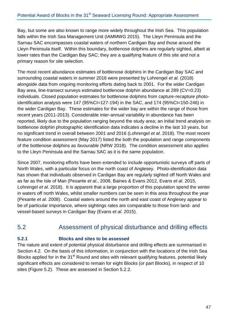
Potential Award of Blocks in the 31st Seaward Licensing Round: Appropriate Assessment
47
Bay, but some are also known to range more widely throughout the Irish Sea. This population
falls within the Irish Sea Management Unit (IAMMWG 2015). The Lleyn Peninsula and the
Sarnau SAC encompasses coastal waters of northern Cardigan Bay and those around the
Lleyn Peninsula itself. Within this boundary, bottlenose dolphins are regularly sighted, albeit at
lower rates than the Cardigan Bay SAC; they are a qualifying feature of this site and not a
primary reason for site selection.
The most recent abundance estimates of bottlenose dolphins in the Cardigan Bay SAC and
surrounding coastal waters in summer 2016 were presented by Lohrengel et al. (2018)
alongside data from ongoing monitoring efforts dating back to 2001. For the wider Cardigan
Bay area, line-transect surveys estimated bottlenose dolphin abundance at 289 (CV=0.23)
individuals. Closed population estimates for bottlenose dolphins from capture-recapture photo-
identification analysis were 147 (95%CI=127-194) in the SAC, and 174 (95%CI=150-246) in
the wider Cardigan Bay. These estimates for the wider bay are within the range of those from
recent years (2011-2013). Considerable inter-annual variability in abundance has been
reported, likely due to the population ranging beyond the study area; an initial trend analysis on
bottlenose dolphin photographic identification data indicates a decline in the last 10 years, but
no significant trend in overall between 2001 and 2016 (Lohrengel et al. 2018). The most recent
feature condition assessment (May 2017) listed the both the population and range components
of the bottlenose dolphins as favourable (NRW 2018). The condition assessment also applies
to the Lleyn Peninsula and the Sarnau SAC as it is the same population.
Since 2007, monitoring efforts have been extended to include opportunistic surveys off parts of
North Wales, with a particular focus on the north coast of Anglesey. Photo-identification data
has shown that individuals observed in Cardigan Bay are regularly sighted off North Wales and
as far as the Isle of Man (Pesante et al., 2008, Baines & Evans 2012, Evans et al. 2015,
Lohrengel et al. 2018). It is apparent that a large proportion of this population spend the winter
in waters off north Wales, whilst smaller numbers can be seen in this area throughout the year
(Pesante et al. 2008). Coastal waters around the north and east coast of Anglesey appear to
be of particular importance, where sightings rates are comparable to those from land- and
vessel-based surveys in Cardigan Bay (Evans et al. 2015).
5.2 Assessment of physical disturbance and drilling effects
5.2.1 Blocks and sites to be assessed
The nature and extent of potential physical disturbance and drilling effects are summarised in
Section 4.2. On the basis of this information, in conjunction with the locations of the Irish Sea
Blocks applied for in the 31st Round and sites with relevant qualifying features, potential likely
significant effects are considered to remain for eight Blocks (or part Blocks), in respect of 10
sites (Figure 5.2). These are assessed in Section 5.2.2.
Potential Award of Blocks in the 31st Seaward Licensing Round: Appropriate Assessment
48
Figure 5.1: Sites and Blocks in the Irish Sea to be subject to further assessment for
physical disturbance and drilling effects

Potential Award of Blocks in the 31st Seaward Licensing Round: Appropriate Assessment
49
5.2.2 Implications for site integrity of relevant sites
The conservation objectives of relevant sites and other relevant information relating to site
selection and advice on operations has been considered against the work programmes for the
Blocks applied for to determine whether they could adversely affect site integrity. The results
are given in Table 5.1 below. All mandatory control requirements (as given in Section 2.3.1)
are assumed to be in place as a standard for all activities assessed here.
Table 5.1: Consideration of potential physical disturbance and drilling effects and
relevant site conservation objectives
Morecambe Bay and Duddon Estuary SPA
Site information
Area (ha): 66,899 Relevant qualifying features: Breeding: common tern, sandwich tern, little tern; over winter: whooper swan, little egret, golden plover, ruff, bar-tailed godwit, Mediterranean gull, lesser black-backed gull, herring gull; On passage: pink-footed goose, shelduck, oystercatcher, ringed plover, grey plover, knot, sanderling, dunlin, black-tailed godwit, curlew, pintail, turnstone, redshank, lesser black-backed gull. Seabird (including herring gull, lesser black-backed gull, Sandwich tern, common tern, little tern) and waterbird (including great egret, spoonbill, brent goose, wigeon, teal, mallard, common eider, goldeneye, red-breasted merganser, cormorant, lapwing, little stint, common greenshank, spotted redshank) assemblage all year round. See Natura 2000 standard data form for details of qualifying features
48
Conservation objectives: Subject to natural change, the integrity of the site is maintained or restored as appropriate, and that the site contributes to achieving the aims of the Wild Birds Directive, by maintaining or restoring:
the extent and distribution of the habitats of the qualifying features
the structure and function of the habitats of the qualifying features
the supporting processes on which the habitats of the qualifying features rely
the populations of qualifying features
the distribution of qualifying features within the site Attributes and related targets have been set for the site features which are presented in the site SACO
49. These
include a number of targets to restore the supporting habitat and breeding populations of gull and tern species, and non-breeding populations of grey plover, dunlin, sanderling and turnstone. Advice on seasonality for the site
50 indicates the key periods when significant numbers of qualifying interests are present (excluding
assemblage features); presence of breeding (March-August) and non-breeding features (July-May) indicate year round presence of qualifying interests. Further relevant information on seasonality is provided below.
Relevant Blocks for physical disturbance and drilling effects
110/4, 113/22
48
http://jncc.defra.gov.uk/pdf/SPA/UK9020326.pdf 49
https://designatedsites.naturalengland.org.uk/Marine/FAPMatrix.aspx?SiteCode=UK9020326&SiteName=&SiteNameDisplay=Morecambe+Bay+and+Duddon+Estuary+SPA&countyCode=&responsiblePerson=&SeaArea=&IFCAArea= 50
https://designatedsites.naturalengland.org.uk/Marine/Seasonality.aspx?SiteCode=UK9020326&SiteName=morecambe&SiteNameDisplay=Morecambe+Bay+and+Duddon+Estuary+SPA&countyCode=&responsiblePerson=&SeaArea=&IFCAArea=

Potential Award of Blocks in the 31st Seaward Licensing Round: Appropriate Assessment
50
Assessment of effects on site integrity
Rig siting (Relevant pressures: penetration and/or disturbance of the substratum below the surface of the seabed, including abrasion, introduction or spread of non-indigenous species)
51
Blocks 110/4 and 113/22 are 3 and 9km respectively from the site boundary and given the assumed distance from a jack-up rig within which effects may occur (500m, see Table 2.2), rig installation will not significantly impact the extent and distribution of the habitats of the qualifying features, and no adverse effects on site integrity are predicted. There may be a requirement for rig stabilisation depending on local seabed conditions (Block 113/22 and part of Block 110/4 are within the east Irish Sea Mudbelt). It should be noted that the advice on operations does not identify physical change (to another seabed type) as a relevant pressure. It is assumed that rock placement (if required) would be within the immediate vicinity of the rig and cover an estimated area of 0.001-0.004km
2 per rig
siting (Table 2.2). Given that the closest Block is at least 3km from the site boundary (110/4), the potential loss of extent of any supporting habitat (outside of the site boundaries) would be small compared to the extent of the circalittoral fine sand and sandy mud habitat across the Block and the wider region. It is concluded that the site conservation objectives will not be undermined and there will be no adverse effect on site integrity. Further assessment, including HRA where appropriate, would be undertaken at the project level, at which stage the assessment would be informed by specific rig siting information. As noted in Section 4.2.5, management of the spread of non-native species from vessels and rigs is being progressed through international measures, and the risk is limited by the operational range of rigs on the UKCS. Drilling discharges (Relevant pressures: abrasion/disturbance of the substrate on the surface of the seabed; habitat structure changes – removal of substratum, contamination). It is assumed that effects relating to drilling discharges occur within 500m of the well location (Table 2.2). Therefore, drilling discharges will not significantly impact the extent and distribution or the structure and function of the habitats of the qualifying features for any Blocks identified as relevant as these are at least 3km from the site boundaries. In any case, the small scale and temporary nature of potential smothering, and mandatory control requirements with respect to drilling chemical use and discharge (Section 2.3.1), will ensure that site conservation objectives are not undermined and there is no adverse effect on site integrity. Other effects (Relevant pressures: visual disturbance, above water noise) Blocks 110/4 and 113/22 are not located within the site and the potential for disturbance to impact the distribution of qualifying features is therefore primarily associated with the movement of supply vessels and helicopters to drilling rigs. Of the qualifying features likely to be present within the site, breeding common tern (May-August), sandwich tern (April-August), lesser black-backed gull (all year) and herring gull (March-August) are all moderately sensitive to disturbance by ship and helicopter traffic (Garthe & Hüppop 2004). Both Blocks 110/4 and 113/22 are currently exposed to high shipping densities, and the temporary nature of drilling activities and limited number of associated supply vessel and helicopter trips (Table 2.2), is unlikely to represent a significant increase in the level of disturbance of moderately sensitive qualifying features. Further control measures are also available (Section 5.2.3) and will be required, where appropriate, to ensure that site conservation objectives are not undermined and there is no adverse effect on site integrity. In-combination effects No intra-plan in-combination effects are likely with respect to the spatial footprints associated with rig siting and drilling discharges given that neither relevant Block (110/4 and 113/22) are located within the site and are distant from one another (~22km). Therefore, the likelihood of in-combination footprint effects is extremely low. There is the potential for in-combination effects associated with the presence and movement of supply vessels to rigs within each of the Blocks. However, given the existing high shipping densities and the limited and temporary supply vessel traffic (see Table 2.2) intra-plan effects are not considered likely for the two Blocks. Further control measures are also available (Section 5.2.3) and will be required, where appropriate, to ensure that site
51
https://designatedsites.naturalengland.org.uk/Marine/MarineSiteDetail.aspx?SiteCode=UK9020326

Potential Award of Blocks in the 31st Seaward Licensing Round: Appropriate Assessment
51
conservation objectives are not undermined and there is no adverse effect on site integrity. Section 5.4 provides a consideration of potential Block activities in-combination with other relevant plans and projects.
Ribble and Alt Estuaries SPA
Site information
Area (ha): 12,450 Relevant qualifying features: Breeding: common tern, ruff; on passage: ringed plover, sanderling, redshank, whimbrel; over winter: bar-tailed godwit, Bewick's swan, golden plover, whooper swan, lesser black-backed gull, black-headed gull, pintail, teal, wigeon, pink-footed goose, scaup, sanderling, dunlin, knot, oystercatcher, black-tailed godwit, common scoter, curlew, cormorant, grey plover, shelduck, redshank, lapwing. Breeding seabird (including lesser black-backed gull, black-headed gull, common tern) and overwintering waterbird (including cormorant, Bewick's swan, whooper swan, pink-footed goose, shelduck, wigeon, teal, pintail, scaup, common scoter, oystercatcher, ringed plover, golden plover, grey plover, lapwing, red knot, sanderling, dunlin, black-tailed godwit, bar-tailed godwit, whimbrel, curlew, redshank) assemblages. See Natura 2000 standard data form for details of qualifying features.
52
Conservation objectives: With regard to the SPA and the individual species and/or assemblage of species for which the site has been classified, and subject to natural change; ensure that the integrity of the site is maintained or restored as appropriate, and ensure that the site contributes to achieving the aims of the Wild Birds Directive, by maintaining or restoring:
the extent and distribution of the habitats of the qualifying features
the structure and function of the habitats of the qualifying features
the supporting processes on which the habitats of the qualifying features rely
the population of each of the qualifying features
the distribution of the qualifying features within the site Attributes and related targets have been set for the site features which are presented in the site SACO
53. These
include a number of targets to restore the abundance and diversity of the breeding seabird assemblage, and the abundance of common tern. Advice on seasonality for the site
54 indicates the key periods when significant
numbers of qualifying interests are present (excluding assemblage features); presence of breeding (April-September) and non-breeding features (all year) indicate year round presence of qualifying interests. Further relevant information on seasonality is provided below.
Relevant Blocks for physical disturbance and drilling effects
110/9c
Assessment of effects on site integrity
Potential effects on the breeding common tern qualifying features when foraging outside of the SPA within the Liverpool Bay SPA are considered against that site separately below. Rig siting (Relevant pressures: penetration and/or disturbance of the substratum below the surface of the seabed, including abrasion; physical change (to another seabed type), introduction or spread of non-indigenous species)
55
Block 110/9c is a minimum of 7.5km from the site boundary and given the assumed distance from a jack-up rig within which effects may occur (500m, see Table 2.2), rig installation will not significantly impact the extent and distribution of the habitats of the qualifying features within the site, or those outside of site boundaries which may
52
http://jncc.defra.gov.uk/pdf/SPA/UK9005103.pdf 53
https://designatedsites.naturalengland.org.uk/Marine/SupAdvice.aspx?SiteCode=UK9020326&SiteName=morecambe&SiteNameDisplay=Morecambe+Bay+and+Duddon+Estuary+SPA&countyCode=&responsiblePerson=&SeaArea=&IFCAArea= 54
https://designatedsites.naturalengland.org.uk/Marine/Seasonality.aspx?SiteCode=UK9005103&SiteName=ribble&SiteNameDisplay=Ribble+and+Alt+Estuaries+SPA&countyCode=&responsiblePerson=&SeaArea=&IFCAArea= 55
https://designatedsites.naturalengland.org.uk/Marine/FAPMatrix.aspx?SiteCode=UK9005103&SiteName=&SiteNameDisplay=Ribble+and+Alt+Estuaries+SPA&countyCode=&responsiblePerson=&SeaArea=&IFCAArea=

Potential Award of Blocks in the 31st Seaward Licensing Round: Appropriate Assessment
52
be used by individuals foraging away from colonies. Common terns forage outside of the site boundaries within the Liverpool Bay SPA for which they are also a qualifying feature, and therefore potential effects on the foraging habitat of this species is considered separately below. With the exception of gull species, the foraging habitats of the remaining species are coastal and there is no foreseeable interaction with these from rig siting. Adverse effects on site integrity are not predicted. There may be a requirement for rig stabilisation depending on local seabed conditions (part of Block 110/9c is within the east Irish Sea Mudbelt). It should be noted that the advice on operations does not identify physical change (to another seabed type) as a relevant pressure. It is assumed that rock placement (if required) would be within the immediate vicinity of the rig and cover an estimated area of 0.001-0.004km
2 per rig siting (Table 2.2).
Given that the Block is at least 7.5km from the site boundary, the potential loss of extent of any supporting habitat (outside of the site boundaries) would be small compared to the extent of the circalittoral fine sand and sandy mud habitat across the Block and the wider region. Moreover, further mitigation measures are available which include use of removable mud mats or anti-scour mats as an alternative to rock placement (Section 5.2.3). It is concluded that the site conservation objectives will not be undermined and there will be no adverse effect on site integrity. Further assessment, including HRA where appropriate, would be undertaken at the project level, at which stage the assessment would be informed by specific rig siting information. As noted in Section 4.2.5, management of the spread of non-native species from vessels and rigs is being progressed through international measures, and the risk is limited by the operational range of rigs on the UKCS. Drilling discharges (Relevant pressures: abrasion/disturbance of the substrate on the surface of the seabed; habitat structure changes - removal of substratum (extraction), contaminants) It is assumed that effects relating to drilling discharges occur within 500m of the well location (Table 2.2). Therefore, drilling discharges will not significantly impact the extent and distribution or the structure and function of the habitats of the qualifying features for Blocks 110/9c as it is 7.5km from the site boundaries. In any case, the small scale and temporary nature of potential smothering, and mandatory control requirements with respect to drilling chemical use and discharge (Section 2.3.1), will ensure that site conservation objectives are not undermined and there is no adverse effect on site integrity. Other effects (Relevant pressures: visual disturbance, above water noise) As the Block is outside of the site boundary, the potential for disturbance to impact the distribution of qualifying features within the site is primarily associated with the movement of supply vessels and helicopters to drilling rigs. The qualifying features are sensitive to visual disturbance and airborne noise although these are low risk pressures
56. Block 110/9c is exposed to low shipping densities
57 and the temporary nature of drilling activities and
limited number of associated supply vessel and helicopter trips (Table 2.2), is unlikely to represent a significant increase in the level of disturbance of the site qualifying features. Further control measures are available (Section 5.2.3) and will be required, where appropriate, to ensure that site conservation objectives are not undermined and there is no adverse effect on site integrity. In-combination effects No intra-plan in-combination effects are likely with respect to the spatial footprints associated with rig siting and drilling discharges given that the Block is outside of the site boundary. There is the potential for in-combination effects associated with the presence and movement of supply vessels to rigs within the Block and other adjacent Blocks which may be licensed in the 31
st Round. However, given the limited and temporary supply vessel traffic
(see Table 2.2) and the potential for a high level of spatial and temporal separation of any 31st Round activities
(the duration of the initial term being up to 9 years), intra-plan effects are not considered likely for the Block. As noted in Section 2.2.2, several of the Blocks may be covered by one licence, and therefore fewer wells are likely to be drilled than the worst case scenario assessed. Section 5.4 provides a consideration of potential Block
56
https://designatedsites.naturalengland.org.uk/Marine/FAPMatrix.aspx?SiteCode=UK9005103&SiteName=&SiteNameDisplay=Ribble+and+Alt+Estuaries+SPA&countyCode=&responsiblePerson=&SeaArea=&IFCAArea= 57
https://www.ogauthority.co.uk/media/1419/29r_shipping_density_table.pdf, https://data.gov.uk/dataset/vessel-density-grid-2015
Potential Award of Blocks in the 31st Seaward Licensing Round: Appropriate Assessment
53
activities in-combination with other relevant plans and projects.
Liverpool Bay/Bae Lerpwl SPA
Site information
Area (ha): 252,773 Relevant qualifying features: Breeding: little tern, common tern; Over winter: red-throated diver, little gull, common scoter Wintering waterbird assemblage (including red-throated diver, little gull, common scoter, cormorant, red-breasted merganser). See Natura 2000 standard data form for details of qualifying features
58
Conservation objectives: Ensure that the integrity of the site is maintained or restored as appropriate, and ensure that the site contributes to achieving the aims of the Wild Birds Directive, by maintaining or restoring:
the extent and distribution of the habitats of the qualifying features
the structure and function of the habitats of the qualifying features
the supporting processes on which the habitats of the qualifying features rely
the population of each of the qualifying features
the distribution of the qualifying features within the site There is currently no advice on seasonality for the site. However, the presence of breeding (April-September, from NE advice on seasonality for Mersey Narrows and North Wirral Foreshore SPA
59) and non-breeding
(October-March, Lawson et al. 2016) features indicate year round presence of qualifying interests. Further relevant information on seasonality is provided below.
Relevant Blocks for physical disturbance and drilling effects
109/15, 110/4, 110/7b, 110/8b, 110/9c, 110/11, 110/12c
Assessment of effects on site integrity
Rig siting (Relevant pressures: penetration and/or disturbance of the substratum below the surface of the seabed, including abrasion; physical change (to another seabed type), introduction or spread of non-indigenous species)
60
Blocks 109/15, 110/11, 110/12c, and 110/7b are all at least 2km from the site boundary and given the assumed distance from a jack-up rig within which effects may occur (500m, see Table 2.2), rig installation will not significantly impact the extent and distribution of the habitats of the qualifying features. This includes the potential requirement for rig stabilisation measures, which would be determined by site-specific survey of local conditions that would also inform stabilisation requirements. In soft sediments, rock placement may cause smothering of existing sediments and a physical change of seabed type. Seabed sediments in Blocks which overlap the site (110/4, 110/8b and 110/9c) are likely to consist of circalittoral fine sand and sandy mud which are widespread. It is assumed that if rock placement is required it would be within 500m of a rig and based on a review of submitted ESs could cover an area of 0.001-0.004km
2 (Table 2.2). Hence, the potential loss of extent of sediment is small
compared to the widespread nature of these sediment types across the large site (2,258km2). Further mitigation
measures are available which include use of removable mud mats or anti-scour mats as an alternative to rock placement (Section 5.2.3). Such measures will be required, where appropriate, to ensure that site conservation objectives are not undermined and there is no adverse effect on site integrity. Further assessment, including HRA where appropriate, would be undertaken at the project level, at which stage the assessment would be informed by specific rig siting information. Blocks 110/4, 110/8b and 110/9c are partly or entirely within the site and coincide with foraging areas for little gull (Lawson et al. 2015) (non-breeding, significant numbers noted March-May and August-November). The foraging
58
http://jncc.defra.gov.uk/pdf/SPA/UK9020294.pdf 59
https://designatedsites.naturalengland.org.uk/Marine/Seasonality.aspx?SiteCode=UK9020287&SiteName=mersey&SiteNameDisplay=Mersey+Narrows+and+North+Wirral+Foreshore+SPA&countyCode=&responsiblePerson=&SeaArea=&IFCAArea= 60
http://publications.naturalengland.org.uk/file/5733149452009472 - note that the “pressure” nomenclature has changed since the publication of the Regulation 35 advice for Liverpool Bay SPA. For the purposes of this assessment, they have been reviewed against the current JNCC pressure-activity database (JNCC 2018) and those considered to be relevant are listed and considered above.

Potential Award of Blocks in the 31st Seaward Licensing Round: Appropriate Assessment
54
ranges of common and little terns are such that these species are unlikely (common tern) or highly unlikely (little tern) to interact with the relevant Blocks. The closest Block to the relevant colony SPAs (110/9c) is 25km from the Mersey Narrows and North Wirral Foreshore SPA, compared to a reported mean maximum foraging range for common tern of 15.2km, while Block 110/9c is 30km from The Dee Estuary SPA, compared to a reported mean maximum foraging range for little tern of 6.3km (Thaxter et al. 2012). Blocks 110/8b and 110/4 have areas outside the site boundaries in which rig siting would be possible, and therefore interaction with the habitats of the qualifying features could be avoided. In the event that a rig is placed in these Blocks, or Block 110/9c, the maximum spatial footprint of physical damage associated with jack-up rig siting is small (0.8km
2) relative to the
size of the site, and effects would be temporary. The eastern half of Blocks 110/4 and 110/9c partly coincide with an area of high common scoter density over winter (Lawson et al. 2016), the distribution of which is strongly associated with the distribution of its benthic prey species (Kaiser et al. 2006). Wintering red-throated diver occur throughout much of the Liverpool Bay SPA, though with greatest densities off the Ribble Estuary, North Wales and the North Wirral Foreshore (Webb et al. 2006), likely coinciding with sandbanks which support key prey species. Benthic communities of sandy sediments are in general relatively resilient to physical damage. However, repeated damage to the habitats (through changes in suspended sediment or physical disturbance such as anchoring) could adversely affect the ability of the habitats to recover, leading to permanent damage and ultimately lead to loss of prey species. This may result in a reduction in the value of habitats as foraging sites for the overwintering populations of common scoter and red-throated diver. Overall the vulnerability of overwintering red-throated divers and common scoters in the Liverpool Bay and associated habitats to physical damage (through siltation and abrasion) and loss (through habitat removal and smothering) is considered to be low or moderate. A single well may be drilled in either of Blocks 110/4 and 110/9c, thus limiting the potential for repeated damage to supporting habitats. In view of the physical scale and temporary nature of the activities, site conservation objectives will not be undermined as a result of abrasion/disturbance resulting from rig siting or the use of stabilisation materials, and there will be no adverse effect on site integrity. As noted in Section 4.2.5, management of the spread of non-native species from vessels and rigs is being progressed through international measures, and the risk is limited by the operational range of rigs on the UKCS. Drilling discharges (Relevant pressures: abrasion/disturbance of the substrate on the surface of the seabed; habitat structure changes - removal of substratum (extraction), contaminants) It is assumed that effects relating to drilling discharges occur within 500m of the well location (Table 2.2). Therefore, with respect to Blocks 109/15, 110/11, 110/12c, and 110/7b which are at least 2km outside of the site, drilling discharges will not result in any impact on the extent and distribution, or structure and function of the habitats of the qualifying features. However, for those Blocks located partly or wholly within the site (as in the case of Blocks 110/4, 110/8b and 110/9c), the maximum spatial footprint within which smothering by drilling discharges may occur (0.8km
2) is small (representing a maximum of 0.095% of the total site area for 3 potential
wells). Physical loss by smothering of any of the habitats on which common scoter depend may result in the loss of foraging sites and therefore the reduction of the food resource for the overwintering population. This would consequently be detrimental to the favourable condition of the interest feature. The overwintering population is considered to be moderately vulnerable to physical loss of habitat through its removal or smothering. However, the small scale (as compared to the extent of supporting habitat) and temporary nature of potential smothering, and mandatory control requirements with respect to drilling chemical use and discharge (Section 2.3.1), will ensure that site conservation objectives are not undermined and there is no adverse effect on site integrity. Other effects (Relevant pressures: visual disturbance, above water noise) Red-throated diver, common scoter and the cormorant feature (all likely to be present October-March) of the wintering waterbird assemblage are highly sensitive to disturbance from ship and helicopter traffic (Garthe & Hüppop 2004, also see Schwemmer et al. 2011 and Mendel et al. 2019) and by extension, are likely to be equally sensitive to other sources of non-physical disturbance, especially those creating noise and/or movement. Disturbance can cause birds to reduce or cease feeding in a given area or to fly away from an area (i.e. be displaced), and advice on operations for the Liverpool Bay SPA notes that vulnerability to such disturbance is high for both the common scoter and red-throated diver features. Given that most of the Blocks are outside of the site or have areas outside of the site boundaries, the potential for disturbance to impact the distribution of qualifying features within the site is primarily associated with the movement of supply vessels and helicopters to drilling rigs (that may be located outside of the site, with the exception of Block 110/9c which is wholly within the site). The

Potential Award of Blocks in the 31st Seaward Licensing Round: Appropriate Assessment
55
Blocks are already exposed to high shipping densities61
and the addition of 2-3 vessels per week (see Table 2.2) is unlikely to be significant in view of weekly variations in overall traffic for the region. In view of the location of the Blocks within the Liverpool Bay SPA and to existing helicopter routes from Blackpool to the Morecambe Bay (Millom, Morecambe and Calder fields) and Liverpool Bay (Douglas, Hamilton and Lennox fields) areas
62, there is
considerable scope for these established routes to be used, thus reducing additional overflight disturbance. Further mitigation measures are available which include seasonal controls (Section 5.2.3). Where appropriate, these will be required to ensure that site conservation objectives are not undermined and there is no adverse effect on site integrity. In-combination effects Intra-plan in-combination effects are possible although spatial footprints associated with rig installation and drilling discharges in the Blocks are localised and temporary and are unlikely to overlap spatially or temporally between Blocks, or with the site (three Blocks are partly or wholly inside the site, and it is highly unlikely that a well will be drilled in each). There is also the potential for in-combination effects associated with the presence and movement of supply vessels and rigs within each of the Blocks. However, drilling operations for the wells are unlikely to coincide either spatially or temporally to such an extent that the level of disturbance would lead to significant adverse impacts on the population or distribution of sensitive qualifying features. As noted in Section 2.2.2, several of the Blocks may be covered by one licence, and therefore fewer wells are likely to be drilled than the worst case scenario assessed. Section 5.4 provides a consideration of potential Block activities in-combination with other relevant plans and projects.
Anglesey Terns / Morwenoliaid Ynys Môn SPA
Site information
Area (ha): 101,931 Relevant qualifying features: Breeding roseate tern, common tern, Arctic tern and Sandwich tern. See Natura 2000 standard data form for details of qualifying features
63
Conservation objectives: The following draft conservation objectives relate to all of the features for the site:
The size of the population should be stable or increasing, allowing for natural variability, and sustainable in the long term
The distribution of the population should be being maintained, or where appropriate increasing
There should be sufficient habitat, of sufficient quality, to support the population in the long term
Factors affecting the population or its habitat should be under appropriate control Each of the above points are defined in the draft objectives in relation to roseate tern, common tern, Arctic tern and Sandwich tern
64. The core management plan
65 for the previous Ynys Feurig, Cemlyn Bay and The Skerries
SPA indicates that the tern breeding season was between May-August.
Relevant Blocks for physical disturbance and drilling effects
109/15
Assessment of effects on site integrity
Rig siting (Relevant pressures: No relevant pressures identified in available site information. The following pressures have been considered on the basis of their relevance to similar sites and the activities associated with oil and gas exploration: penetration and/or disturbance of the substratum below the surface of the seabed, including abrasion; physical change (to another seabed type), introduction or spread of non-indigenous species) The site boundary was selected on the basis of the foraging area for each tern species determined using a combination of observed behaviour and environmental variables (see Section 5.1). In view of the distance
61
https://www.ogauthority.co.uk/media/1419/29r_shipping_density_table.pdf, https://data.gov.uk/dataset/vessel-density-grid-2015 62
https://www.aurora.nats.co.uk/htmlAIP/Publications/2019-01-31-AIRAC/graphics/41010.pdf 63
http://jncc.defra.gov.uk/pdf/SPA/UK9013061.pdf 64
https://cdn.naturalresources.wales/media/675726/anglesey-terns-pspa-draft-conservation-objectives-final.pdf?mode=pad&rnd=131625760740000000 65
https://naturalresources.wales/media/671214/Cemlyn%20WES32%20plan%20English.pdf

Potential Award of Blocks in the 31st Seaward Licensing Round: Appropriate Assessment
56
between Block 109/15 and the site boundary (3.5km), and the distance from a jack-up rig within which effects may occur (500m, see Table 2.2), rig installation and any associated stabilisation (if required) will not significantly impact the extent and distribution of the habitats of the qualifying features. No adverse effect on site integrity. Drilling discharges (Relevant pressures: No relevant pressures identified in available site information. The following pressures have been considered on the basis of their relevance to similar sites and the activities associated with oil and gas exploration: abrasion/disturbance of the substrate on the surface of the seabed; habitat structure changes – removal of substratum, contamination). It is assumed that effects relating to drilling discharges occur within 500m of the well location (Table 2.2). Therefore, in view of the distance between Block 109/15 and the site boundary (3.5km), drilling discharges will not significantly impact the extent and distribution or the structure and function of the habitats of the qualifying features. No adverse effect on site integrity. Other effects (Relevant pressures: No relevant pressures identified in available site information. The following pressures have been considered on the basis of their relevance to similar sites and the activities associated with oil and gas exploration: visual disturbance, above water noise) Given that the Block is outside of the site boundary, which was selected based on areas of high tern usage (see Section 5.1), the potential to impact the distribution of qualifying features within the site (present May-August) is primarily associated with the movement of supply vessels and helicopters to drilling rigs, noting that the qualifying features are moderately sensitive to disturbance by shipping (Garth & Hüppop 2004). Typical helicopter routes taken to facilities in the Irish Sea are such that they are unlikely to interact with the site
66. The southern and
central parts of Block 109/15 are exposed to moderate to high shipping densities from vessels travelling between Liverpool and the IMO traffic separation scheme to the north of Anglesey, with other parts of the Block experiencing relatively low levels of traffic
67. The temporary nature of drilling activities and limited number of
associated supply vessel and helicopter trips (Table 2.2), is unlikely to represent a significant increase in the level of disturbance of the site qualifying features. Further control measures are available (Section 5.2.3) and will be required, where appropriate, to ensure that site conservation objectives are not undermined and there is no adverse effect on site integrity. In-combination effects No intra-plan in-combination effects are likely with respect to the spatial footprints associated with rig siting and drilling discharges given that the Block is outside of the site boundary. There is the potential for in-combination effects associated with the presence and movement of supply vessels to rigs within the Block. However, given the existing moderate to high shipping densities and the limited and temporary supply vessel traffic (see Table 2.2) intra-plan effects are not considered likely for the Block. As noted in Section 2.2.2, several of the Blocks may be covered by one licence, and therefore fewer wells are likely to be drilled than the worst case scenario assessed. Section 5.4 provides a consideration of potential Block activities in-combination with other relevant plans and projects.
Drigg Coast SAC
Site information
Area (ha): 1,397 Relevant qualifying features: estuaries, coastal dunes, mudflats and sandflats, saltmarsh and salt meadows. See Natura 2000 standard data form for details of qualifying features
68
Conservation objectives: With regard to the SAC and the natural habitats and/or species for which the site has been designated (the ‘Qualifying Features’ listed below), and subject to natural change; ensure that the integrity of the site is maintained or restored as appropriate, and ensure that the site contributes to achieving the Favourable Conservation Status of its Qualifying Features, by maintaining or restoring:
66
https://www.aurora.nats.co.uk/htmlAIP/Publications/2019-01-31-AIRAC/graphics/41010.pdf 67
https://www.ogauthority.co.uk/media/1419/29r_shipping_density_table.pdf, https://data.gov.uk/dataset/vessel-density-grid-2015 68
http://publications.naturalengland.org.uk/file/3019081

Potential Award of Blocks in the 31st Seaward Licensing Round: Appropriate Assessment
57
the extent and distribution of qualifying natural habitats and habitats of qualifying species
the structure and function (including typical species) of qualifying natural habitats
the structure and function of the habitats of qualifying species
the supporting processes on which qualifying natural habitats and the habitats of qualifying species rely
the populations of qualifying species
the distribution of qualifying species within the site Attributes and related targets have been set for the site features which are presented in the site SACO
69.
Relevant Blocks for physical disturbance and drilling effects
113/22
Assessment of effects on site integrity
Rig siting (Relevant pressures: penetration and/or disturbance of the substratum below the surface of the seabed, including abrasion; physical change (to another seabed type), introduction or spread of invasive non-indigenous species)
70
In view of the distance between Block 113/22 and the site boundary (at least 8.5km), and the distance from a jack-up rig within which effects may occur (500m, see Table 2.2), rig installation and any associated stabilisation (if required) will not significantly impact the extent and distribution of the qualifying habitats, or their related species, and there will be no adverse effect on site integrity. Drilling discharges (Relevant pressures: abrasion/disturbance of the substrate on the surface of the seabed; habitat structure changes - removal of substratum (extraction), contaminants) It is assumed that effects relating to drilling discharges occur within 500m of the well location (Table 2.2). Therefore, in view of the distance between Block 113/22 and the site boundary (8.5km), drilling discharges will not significantly impact the extent and distribution or the structure and function of the habitats of the qualifying features. No adverse effect on site integrity. Other effects None In-combination effects In view of the distance of all of the Blocks applied for from the site, and the relative spatial and temporal separation of activities which could follow licensing, no intra-plan in-combination effects are considered to be likely. Section 5.4 provides a consideration of potential Block activities in-combination with other relevant plans and projects.
Morecambe Bay SAC
Site information
Area (ha): 61,506 Relevant qualifying features: estuaries, mudflats and sandflats, inlets and bays, vegetation of stony banks, saltmarsh and salt meadows, coastal dunes, sandbanks, coastal lagoons, reefs, great crested newt. See Natura 2000 standard data form for details of qualifying features
71
Conservation objectives: With regard to the natural habitats and/or species for which the site has been designated, and subject to natural change; ensure that the integrity of the site is maintained or restored as appropriate, and ensure that the site contributes to achieving the Favourable Conservation Status of its Qualifying Features, by maintaining or
69
https://designatedsites.naturalengland.org.uk/Marine/SupAdvice.aspx?SiteCode=UK0013031&SiteName=drigg+coast&SiteNameDisplay=Drigg+Coast+SAC&countyCode=&responsiblePerson=&SeaArea=&IFCAArea= 70
https://designatedsites.naturalengland.org.uk/Marine/FAPMatrix.aspx?SiteCode=UK0013031&SiteName=drigg%20coast&SiteNameDisplay=Drigg+Coast+SAC&countyCode=&responsiblePerson=&SeaArea=&IFCAArea= 71
http://jncc.defra.gov.uk/protectedsites/sacselection/n2kforms/UK0013027.pdf

Potential Award of Blocks in the 31st Seaward Licensing Round: Appropriate Assessment
58
restoring:
the extent and distribution of qualifying natural habitats and habitats of qualifying species
the structure and function (including typical species) of qualifying natural habitats
the structure and function of the habitats of qualifying species
the supporting processes on which qualifying natural habitats and habitats of qualifying species rely
the populations of qualifying species
the distribution of qualifying species within the site Attributes and related targets have been set for the site features which are presented in the site SACO
72.
Relevant Blocks for physical disturbance and drilling effects
110/4
Assessment of effects on site integrity
Rig siting (Relevant pressures: penetration and/or disturbance of the substratum below the surface of the seabed, including abrasion; physical change (to another seabed type), introduction or spread of invasive non-indigenous species)
73
In view of the distance between Block 110/4 and the site boundary (approximately 2km), and the distance from a jack-up rig within which effects may occur (500m, see Table 2.2), rig installation and any associated stabilisation (if required) will not significantly impact the extent and distribution of the qualifying habitats, or their related species, and there will be no adverse effect on site integrity. Drilling discharges (Relevant pressures: abrasion/disturbance of the substrate on the surface of the seabed; habitat structure changes – removal of substratum, contamination). It is assumed that effects relating to drilling discharges occur within 500m of the well location (Table 2.2). Therefore, in view of the distance between Block 110/4 and the site boundary (2km), drilling discharges will not significantly impact the extent and distribution or the structure and function of the habitats of the qualifying features. No adverse effect on site integrity. Other effects None In-combination effects In view of the distance of all of the Blocks applied for from the site, and the relative spatial and temporal separation of activities which could follow licensing, no intra-plan in-combination effects are considered to be likely. Section 5.4 provides a consideration of potential Block activities in-combination with other relevant plans and projects.
Shell Flat and Lune Deep SAC
Site information
Area (ha): 10,565 Relevant qualifying features: Sandbanks which are slightly covered by sea water all the time, reefs. See Natura 2000 standard data form for details of qualifying features
74
Conservation objectives: The objectives are to ensure that, subject to natural change, the integrity of the site is maintained or restored as appropriate, and that the site contributes to achieving the Favourable Conservation Status of its qualifying features, by maintaining or restoring:
72
https://designatedsites.naturalengland.org.uk/Marine/SupAdvice.aspx?SiteCode=UK0013027&SiteName=morecambe&SiteNameDisplay=Morecambe+Bay+SAC&countyCode=&responsiblePerson=&SeaArea=&IFCAArea= 73
https://designatedsites.naturalengland.org.uk/Marine/FAPMatrix.aspx?SiteCode=UK0013027&SiteName=morecambe&SiteNameDisplay=Morecambe+Bay+SAC&countyCode=&responsiblePerson=&SeaArea=&IFCAArea= 74
http://jncc.defra.gov.uk/protectedsites/sacselection/n2kforms/UK0030376.pdf

Potential Award of Blocks in the 31st Seaward Licensing Round: Appropriate Assessment
59
the extent and distribution of qualifying natural habitats and habitats of the qualifying species
the structure and function (including typical species) of qualifying natural habitats
the structure and function of the habitats of the qualifying species
the supporting processes on which qualifying natural habitats and the habitats of qualifying species rely
the populations of qualifying species
the distribution of qualifying species within the site Attributes and related targets have been set for the site features which are presented in the site SACO
75.
Relevant Blocks for physical disturbance and drilling effects
110/4, 110/8b, 110/9c
Assessment of effects on site integrity
Rig siting (Relevant pressures: penetration and/or disturbance of the substratum below the surface of the seabed, including abrasion; physical change (to another seabed type), introduction or spread of invasive non-indigenous species)
76
Block 110/8b is a minimum of 3.5km from the site boundary and given the assumed distance from a jack-up rig within which effects may occur (500m, see Table 2.2), rig installation will not significantly impact the extent and distribution of the qualifying features. Blocks 110/4 and 110/9c have significant areas outside the site boundaries in which rig siting would be possible (note that only one well is likely to be drilled), and therefore interaction with the qualifying features could be avoided. If located within the site, the maximum spatial footprint of physical damage associated with jack-up rig siting is small (0.8km
2) relative to the size of the site (approximately 96km
2
covering the Shell Flat sandbank and 9km2 covering Lune Deep), but the qualifying features are sensitive to
disturbance and abrasion pressures. Recovery from physical damage of the scale associated with rig placement would be rapid for Shell Flat in light of typical sandbank communities which are adapted to erosion and accretion; the more stable boulder and bedrock reef of Lune Deep being more sensitive to abrasion/disturbance
77. Further
mitigation measures are available (Section 5.2.3) and will be required, where appropriate, to ensure that site conservation objectives are not undermined and there is no adverse effect on site integrity. The requirement for rig stabilisation measures would be determined by site survey of local conditions. In soft sediments (which includes the circalittoral muds and muddy sands covering much of the relevant Blocks), rock placement may cause smothering of existing sediments and a physical change of seabed type. The potential requirement for rig stabilisation measures would be determined by site-specific survey of local conditions that would also inform stabilisation requirements. With respect to Blocks 110/4 and 110/9c, there are significant areas outside of the site boundaries in which rig siting and stabilisation would be possible, and therefore interaction with the qualifying features could be avoided. If located within the site, it is assumed that if rock placement is required it would be within 500m of a rig and based on a review of submitted ESs it could cover an area of 0.001-0.004km
2
(Table 2.2), which is small relative to the overall size of the site. Further mitigation measures are available (see Section 5.2.3) and will be required, where appropriate, to ensure that site conservation objectives are not undermined and there is no adverse effect on site integrity. Further assessment, including HRA where appropriate, would be undertaken at the project level, at which stage the assessment would be informed by specific rig siting information. As noted in Section 4.2.5, management of the spread of non-native species from vessels and rigs is being progressed through international measures, and the risk is limited by the operational range of rigs on the UKCS. Drilling discharges (Relevant pressures: abrasion/disturbance of the substrate on the surface of the seabed; habitat structure
75
https://designatedsites.naturalengland.org.uk/Marine/SupAdvice.aspx?SiteCode=UK0030376&SiteName=shell%20flat&SiteNameDisplay=Shell+Flat+and+Lune+Deep+SAC&countyCode=&responsiblePerson=&SeaArea=&IFCAArea= 76
https://designatedsites.naturalengland.org.uk/Marine/FAPMatrix.aspx?SiteCode=UK0030376&SiteName=shell+flat&SiteNameDisplay=Shell+Flat+and+Lune+Deep+SAC&countyCode=&responsiblePerson=&SeaArea=&IFCAArea= 77
http://publications.naturalengland.org.uk/file/3268971

Potential Award of Blocks in the 31st Seaward Licensing Round: Appropriate Assessment
60
changes - removal of substratum (extraction)) It is assumed that effects relating to drilling discharges occur within 500m of the well location (Table 2.2) and therefore drilling discharges will not significantly impact the extent and distribution or the structure and function of the qualifying features given the distance of Block 110/8b. With respect to Blocks 110/4 and 110/9c, as mentioned above there are significant areas outside the site in which drilling discharges would not impact the site. However, if located within the site, the maximum spatial footprint within which smothering by drilling discharges may occur (0.8km
2) is small. The qualifying features are sensitive to smothering and siltation rate changes,
however it is noted that this is generally low for Lune Deep due to the high degree of natural sediment influence there and relatively high level of recoverability, and also for Shell Flat due to frequent disturbance and recoverability
77. The small scale and temporary nature of potential smothering and the potential for further
mitigation measures to be implemented once project plans are known (Section 5.2.3), will ensure that site conservation objectives are not undermined and there is no adverse effect on site integrity. Other effects None. In-combination effects No intra-plan in-combination effects are likely with respect to the spatial footprints associated with rig siting and drilling discharges given that only one well is likely to be drilled in any of the Blocks, and those others applied for are some distance from the Shell Flat and Lune Deep SAC. Section 5.3 provides a consideration of potential Block activities in-combination with other relevant plans and projects.
North Anglesey Marine / Gogledd Môn Forol SAC
Site information
Area (ha): 324,949 Relevant qualifying features: harbour porpoise. See Natura 2000 standard data form for details of qualifying features
78
Conservation objectives: To ensure that the integrity of the site is maintained and that it makes the best possible an contribution to maintaining Favourable Conservation Status for harbour porpoise in UK waters. In the context of natural change, this will be achieved by ensuring that:
Harbour porpoise is a viable component of the site;
There is no significant disturbance of the species; and
The condition of supporting habitats and processes, and the availability of prey is maintained.
Relevant Blocks for physical disturbance and drilling effects
109/15
Assessment of effects on site integrity
Rig siting (Relevant pressures: No relevant pressures identified in available site information
79. In view of available
pressure definitions (e.g. the current JNCC pressures-activity database), the following potential pressures are assessed: penetration and/or disturbance of the substrate below the surface of the seabed, including abrasion; physical change (to another seabed type) The delineation of the North Anglesey Marine site was based on the prediction of ‘harbour porpoise habitat’ within the wider UK seas, including the Irish Sea (Heinänen & Skov 2015). The analysis indicated a preference for shallow water depths (<40m) throughout the year, with current speed, eddy potential and the coarseness of the seabed sediment (such as sand/gravel)
80 also being important. Physical damage to benthic habitats through
disturbance or abrasion by the placement of spud cans as part of rig installation or smothering of existing sediments and a physical change of seabed type from the placement of rig stabilisation material (if required), has the potential to impact on the extent of supporting habitat within the site. It is assumed that physical damage effects occur within 500m of the rig location (Table 2.2) and therefore no adverse effects on site integrity are expected for Block 109/15 which is beyond this distance from the site (at least 6.5km).
78
http://jncc.defra.gov.uk/protectedsites/sacselection/n2kforms/UK0030398.pdf 79
http://jncc.defra.gov.uk/pdf/NAnglesey_ConsAdvice.pdf 80
http://jncc.defra.gov.uk/pdf/NorthAngleseyMarineSelectionAssessmentDocument.pdf

Potential Award of Blocks in the 31st Seaward Licensing Round: Appropriate Assessment
61
Drilling discharges (Relevant pressures: Contaminants. Given draft nature of advice, the following potential pressures also assessed: abrasion/disturbance of the substrate on the surface of the seabed; habitat structure changes – removal of substratum) It is assumed that effects relating to drilling discharges occur within 500m of the well location (Table 2.2). Therefore, with respect to Block 109/15, drilling discharges will not significantly impact the extent and distribution or the structure and function of the habitats of the qualifying features. No adverse effect on site integrity. Other effects None In-combination effects In view of the distance of all of the Blocks applied for from the site, and the relative spatial and temporal separation of activities which could follow licensing, no intra-plan in-combination effects are considered to be likely. Section 5.4 provides a consideration of potential Block activities in-combination with other relevant plans and projects.
5.2.3 Further mitigation measures
Further mitigation measures are available which are identified through the EIA process and
operator’s environmental management system and the BEIS permitting processes. These
considerations are informed by project specific plans and the nature of the sensitivities
identified from detailed seabed information collected in advance of field activities taking place.
Site surveys are required to be undertaken before drilling rig placement (for safety and
environmental reasons) and the results of such surveys (survey reports) allow for the
identification of further mitigation including the siting of activities (e.g. rig leg positions) to
ensure sensitive seabed surface features (such as reefs) are avoided and potential rig
stabilisation issues (e.g. from scouring around spud cans, or soft sediment conditions) are
minimised. Survey reports are used to underpin operator environmental submissions (e.g.
EIAs) and where requested, survey reports are made available to nature conservation bodies
during the consultation phases of these assessments81.
It is not typical for rig stabilisation to be required, but this will be informed by site-specific
survey and project specific plans which are not currently available. Where rig stabilisation is
required, BEIS will expect operators to provide adequate justification for the stabilisation option
proposed (including for rig siting beyond site boundaries if practical), and consider use of
systems (e.g. anti-scour mats, mud mats) that can be removed following drilling. Where rock
placement is required for rig stabilisation, BEIS will expect operators to minimise the volume of
rock deposited.
For those Blocks where proposed activities could result in the physical disturbance of sensitive
qualifying features by vessels and aircraft traffic (e.g. divers and scoter for example in relation
to Liverpool Bay SPA), available mitigation measures include, as far as possible, strict use of
existing shipping and aircraft routes, and timing controls on temporary activities to avoid
81
Whether within or outside an SAC, rig site survey typically includes a consideration of the presence of, amongst other sensitivities, Annex I habitats.
Potential Award of Blocks in the 31st Seaward Licensing Round: Appropriate Assessment
62
sensitive periods (these are identified in Table 5.1 above). Operators must demonstrate
awareness of relevant seasonal sensitivities, and that these have been taken into account in
the planning of their operations to avoid highly sensitive periods (see BEIS 2019). In areas of
high sensitivity, BEIS expect operators to liaise with relevant SNCBs on the timing of their
intended activities to minimise or avoid effects on seasonally sensitive qualifying interests.
In all instances, consent for project-level activities will not be granted unless the operator can
demonstrate that the proposed exploration activities will not have an adverse effect on the
integrity of relevant sites. The information provided by operators in their applications must be
detailed enough for BEIS (and its advisors) to make a decision on whether the activities could
lead to a likely significant effect.
5.2.4 Conclusions
Likely significant effects identified with regards to physical damage to the seabed, drilling
discharges and other effects (see Section 5.2.2) when considered along with project-level
mitigation (Section 5.2.3) and relevant activity permitting (see Sections 2.3), will not have an
adverse effect on the integrity of the Natura 2000 sites considered in this assessment. There
is a legal framework through the implementation of the EIA Regulations82 and the Habitats
Directive, to ensure that there are no adverse effects on the integrity of Natura 2000 sites.
These would be applied at the project level, at which point there will be sufficient definition to
make an assessment of likely significant effects, and for applicants to propose project specific
mitigation measures.
Taking into account the information presented above, it is concluded that activities arising from
the licensing of Blocks 109/15, 110/4, 110/7b, 110/8b, 110/9c, 110/11, 110/12c, 113/22, in so
far as they may generate physical disturbance and drilling effects, will not cause an adverse
effect on the integrity of the relevant sites identified. Following award of any licence, consent
for activities will not be granted unless the operator can demonstrate that the proposed
activities will not have an adverse effect on the integrity of relevant sites.
5.3 Assessment of underwater noise effects
5.3.1 Blocks and sites to be assessed
The nature and extent of potential underwater noise effects are summarised in Section 4.3.
On the basis of this information, the location of Irish Sea Blocks applied for in the 31st Round
and the sites with relevant qualifying features, potential likely significant effects are considered
to remain for 11 Blocks (or part Blocks), in respect of six sites (Figure 5.2).
5.3.2 Implications for site integrity of relevant sites
The site conservation objectives and other relevant information relating to site selection and
advice on operations has been considered against indicative Block work programmes (see
82
The Offshore Petroleum Production and Pipelines (Assessment of Environmental Effects) Regulations 1999 (as amended)

Potential Award of Blocks in the 31st Seaward Licensing Round: Appropriate Assessment
63
Section 2.2.1) to determine whether they could adversely affect site integrity, i.e. impacts the
site features, either directly or indirectly, and result in altering the ecological structure and
functioning of the site and/or affects the ability of the site to meet its conservation objectives.
The results are given in Table 5.2 below. All mandatory control requirements (as given in
Section 2.3.2) are assumed to be in place as a standard for all activities assessed at this
stage.

Potential Award of Blocks in the 31st Seaward Licensing Round: Appropriate Assessment
64
Figure 5.2: Sites and Blocks in the Irish Sea to be subject to further assessment for
underwater noise effects

Potential Award of Blocks in the 31st Seaward Licensing Round: Appropriate Assessment
65
Table 5.2: Consideration of potential underwater noise effects and relevant site
conservation objectives
Morecambe Bay and Duddon Estuary SPA
Site information
Area (ha): 66,899.97 Relevant qualifying features (diving species only): Year-round waterbird assemblage (including eider, goldeneye, red-breasted merganser, cormorant) Conservation objectives: See Table 5.1 above.
Relevant Blocks for underwater noise effects
110/4, 110/9c, 113/22
Assessment of effects on site integrity
None of the relevant Blocks overlap the site; Block 110/9c lies within 3km of the site boundary, while Blocks 110/4 and 113/22 are 8 and 13km distant, respectively. The qualifying species all favour shallow, coastal waters and are unlikely to spend significant time, or occur in significant numbers, in waters offshore of the site boundaries. Impulsive noise (rig site survey, VSP, conductor piling) (Relevant pressures: underwater noise change, vibration) The licence applications for the relevant Blocks do not propose any new 3D seismic survey within their work programmes. Consequently, rig site survey, VSP and conductor piling are the relevant sources of impulsive noise, all of which are of a lower amplitude, shorter duration and smaller geographic footprint compared to larger scale 2D or 3D seismic survey. As detailed in Section 4.3.2, there is very little evidence of impacts of underwater noise on diving birds. Mortality of seabirds has not been observed during extensive seismic operations in the North Sea and elsewhere, and flushing disturbance associated with the physical presence of survey vessels and rigs would be expected to displace most diving seabirds from close proximity to noise sources. Such avoidance behaviour is also expected to reduce the potential for diving birds to be exposed to noise levels which may result in potential behavioural disturbance, although it is noted that very little evidence for such effects exist and, should they occur, they would be expected to be short-term, temporary and of limited spatial extent. Negative indirect effects of impulsive noise on qualifying features may arise through effects on prey species, primarily small fish, if those prey are subject to injury or disturbance which reduce their availability to qualifying seabirds. Such effects are not anticipated for eider or goldeneye, as their diet in coastal habitats is largely restricted to molluscs and crustaceans. While there is evidence that a reduction in fish catches can be associated with seismic survey activity, these are temporary in nature. Any such effects associated with VSP or rig site survey are expected to be minor, considering their shorter duration, smaller spatial extent and lower amplitude source relative to the 2D and 3D seismic surveys (to which most reported effects relate). The disturbance of sensitive spawning periods for potential fish prey species will also be considered through the activity consenting process. Consequently, any underwater noise effects on fish associated with the licensing of relevant Blocks are not anticipated to result in significant effects on the food resources of the qualifying diving bird features. Considering the above, particularly the noise source characteristics and distance between the relevant Blocks and the site; when combined with mandatory control measures (Section 2.3.2), disturbance to qualifying features or their prey is highly unlikely and should any such effects occur, they will be highly localised, short-term, and will not result in an adverse effect on site integrity. Continuous noise (drilling, vessel & rig movements) (Relevant pressures: underwater noise change, vibration) No significant effects on the relevant qualifying species are anticipated from continuous underwater noise from drilling and vessel movements due to the lower amplitude and non-impulsive nature of the sound resulting in no potential for acute trauma and no evidence of significant disturbance to diving birds from such sources. In-combination effects Intra-plan in-combination underwater noise effects are considered highly unlikely given the low potential for effects identified above and the lack of any overlap between relevant Blocks and the site. Section 5.4 provides a consideration of potential Block activities in-combination with other relevant plans and projects.

Potential Award of Blocks in the 31st Seaward Licensing Round: Appropriate Assessment
66
Ribble and Alt Estuaries SPA
Site information
Area (ha): 12,361.13 Relevant qualifying features (diving species only): Overwintering waterbird assemblage (including cormorant, common scoter) Conservation objectives: See Table 5.1 above.
Relevant Blocks for underwater noise effects
110/4, 110/9c
Assessment of effects on site integrity
None of the relevant Blocks overlap the site; Block 110/9c lies a minimum of 7km west of the site boundary off the mouth of the Ribble estuary, while Block 110/4 is >10km to the northwest of the site. The cormorant and common scoter qualifying features may use areas outside of the site boundaries as they move between adjacent bays/estuaries and coastal waters; however, their occurrence in these areas and likely interaction with relevant Blocks is considered through their listing as qualifying features of the neighbouring Liverpool Bay SPA and Morecambe Bay and Duddon Estuary SPA. Impulsive noise (rig site survey, VSP, conductor piling) (Relevant pressures: underwater noise change, vibration) The licence applications for the relevant Blocks do not propose any new 3D seismic survey within their work programmes. Consequently, rig site survey, VSP and conductor piling are the relevant sources of impulsive noise, all of which are of a lower amplitude, shorter duration and smaller geographic footprint compared to larger scale 2D or 3D seismic survey. As detailed in Section 4.3.2, there is very little evidence of impacts of underwater noise on diving birds. Mortality of seabirds has not been observed during extensive seismic operations in the North Sea and elsewhere, and flushing disturbance associated with the physical presence of survey vessels and rigs would be expected to displace most diving seabirds from close proximity to noise sources, particularly in the case of common scoter which are known to display a large avoidance radius of vessels and surface infrastructure (up to several kilometres). Such avoidance behaviour is also expected to reduce the potential for diving birds to be exposed to noise levels which may result in potential behavioural disturbance, although it is noted that very little evidence for such effects exist and, should they occur, they would be expected to be short-term, temporary and of limited spatial extent. Considering the seasonal nature of the sensitivity, where necessary, control of timing of offshore activities allows for mitigation, which would be identified once project plans are known. The diet of common scoter in the non-breeding season is dominated by sessile bivalve molluscs; as such, underwater noise effects on prey species are not anticipated. While cormorant are piscivorous and their fish prey species have the potential to be temporarily displaced by underwater noise; however, such effects are considered highly unlikely to significantly impact upon the qualifying feature given nature of the noise source and distance between the Block and the site. Considering the above, particularly the noise source characteristics and distance between the relevant Blocks and the site; when combined with mandatory control measures (Section 2.3.2), disturbance to qualifying features or their prey is highly unlikely and should any such effects occur, they will be highly localised, short-term, and will not result in an adverse effect on site integrity. Continuous noise (drilling, vessel & rig movements) (Relevant pressures: underwater noise change, vibration) No significant effects on the relevant qualifying species are anticipated from continuous underwater noise from drilling and vessel movements due to the lower amplitude and non-impulsive nature of the sound resulting in no potential for acute trauma and no evidence of significant disturbance to diving birds from such sources. In-combination effects Intra-plan in-combination underwater noise effects are considered highly unlikely given the low potential for effects identified above and that there are only two Blocks relevant to the site for such effects, both of which are ≥7km distant. Section 5.4 provides a consideration of potential Block activities in-combination with other relevant plans and projects

Potential Award of Blocks in the 31st Seaward Licensing Round: Appropriate Assessment
67
Liverpool Bay SPA
Site information
Area (ha): 252,773 Relevant qualifying features (diving species only): Overwintering red-throated diver, common scoter; overwintering waterbird assemblage (including common scoter, red-throated diver, red-breasted merganser, and cormorant). Conservation objectives: See Table 5.1 above.
Relevant Blocks for underwater noise effects
109/15, 110/1, 110/4, 110/6, 110/7b, 110/8b, 110/9c, 110/11, 110/12c
Assessment of effects on site integrity
The majority of Block 110/4 overlaps the site, Block 110/9c overlaps entirely, and approximately half of Block 110/8b overlaps the site. Block 110/7b is a minimum of 2km from the site boundary, while the remaining five relevant Blocks are all >5km from the site boundary. The areas within Liverpool Bay SPA identified as supporting the highest densities of red-throated diver over winter are to the south of Blocks 110/4, 110/8b and 110/9c (Lawson et al. 2016). The eastern half of Block 110/9c overlaps an area identified as supporting a moderate (relative to the rest of the SPA) density of red-throated diver. While the distribution of these mobile species within the site will vary, there appears to be limited spatial overlap between the Blocks and those areas of greatest importance for divers and therefore a low potential for underwater noise effects. The eastern half of Blocks 110/4 and 110/9c partially overlap an area identified as supporting high densities of common scoter density over winter; all other relevant Blocks show no overlap with surveyed areas in the greater Liverpool Bay region shown to be of particular importance to common scoter (Lawson et al. 2016). The distribution of cormorant within the site during winter shows the majority of birds to occur in inshore areas which do not overlap with the relevant Blocks, including the adjacent bays and estuaries from Morecambe south to the Dee Estuary (Kober et al. 2010), while red-breasted merganser also favour inshore waters. Impulsive noise (rig site survey, VSP, conductor piling) (Relevant pressures: underwater noise change, vibration) The licence applications for the relevant Blocks do not propose any new 3D seismic survey within their work programmes. Consequently, rig site survey, VSP and conductor piling are the relevant sources of impulsive noise, all of which are of a lower amplitude, shorter duration and smaller geographic footprint compared to larger scale 2D or 3D seismic survey. As detailed in Section 4.3.2, there is very little evidence of impacts of underwater noise on diving birds. Mortality of seabirds has not been observed during extensive seismic operations in the North Sea and elsewhere, and flushing disturbance associated with the physical presence of survey vessels and rigs would be expected to displace most diving seabirds from close proximity to noise sources, particularly in the case of divers and scoters which are known to display a large avoidance radius of vessels and surface infrastructure (up to several kilometres – see Section 5.2.2). Such avoidance behaviour is also expected to reduce the potential for diving birds to be exposed to noise levels which may result in potential behavioural disturbance, although it is noted that very little evidence for such effects exist and, should they occur, they would be expected to be short-term, temporary and of limited spatial extent. Considering the seasonal nature of the sensitivity, where necessary, control of timing of offshore activities allows for mitigation, which would be identified once project plans are known. Negative indirect effects of impulsive noise on qualifying features may arise through effects on prey species, primarily small fish, if those prey are subject to injury or disturbance which reduce their availability to qualifying seabirds. Such effects relate to the primarily piscivorous red-throated diver, as the winter diet of common scoter is largely restricted to sessile bivalves on the seabed (Fox 2003). While there is some evidence that a reduction in fish catches can be associated with seismic survey activity, these effects are temporary in nature. Any such, effects associated with VSP or rig site survey are expected to be minor, considering their shorter duration, smaller spatial extent and lower amplitude source relative to 2D and 3D seismic surveys (to which most reported effects relate). The disturbance of sensitive spawning periods for potential fish prey species will also be considered through the activity consenting process. Consequently, any underwater noise effects on fish associated with the licensing of relevant Blocks are not anticipated to result in significant effects on the food resources of the qualifying diving bird features. Considering the noise source characteristics, the location of the majority of the Blocks relative to the distribution of

Potential Award of Blocks in the 31st Seaward Licensing Round: Appropriate Assessment
68
qualifying features within the site, the propensity of strong avoidance of surface structures by the qualifying features, and the short duration of the activities; when combined with mandatory control measures (Section 2.3.2), any disturbance to qualifying features or their prey will be highly localised, short-term, and will not result in an adverse effect on site integrity. Continuous noise (drilling, vessel & rig movements) (Relevant pressures: underwater noise change, vibration) No significant effects on the relevant qualifying species are anticipated from continuous underwater noise from drilling and vessel movements due to the lower amplitude and non-impulsive nature of the sound resulting in no potential for acute trauma and no evidence of significant disturbance to diving birds from such sources. In-combination effects Intra-plan in-combination underwater noise effects are considered highly unlikely given the low potential for effects identified above and the likely temporal and spatial separation of any 31
st Round activities which could take place
in the Blocks. Section 5.4 provides a consideration of potential Block activities in-combination with other relevant plans and projects.
North Anglesey Marine / Gogledd Môn Forol SAC
Site information
Area (ha): 324,949 Relevant qualifying features: Harbour porpoise Conservation objectives: See Table 5.1 above.
Relevant Blocks for underwater noise effects
109/10, 109/15
Assessment of effects on site integrity
None of the relevant Blocks overlap the site. Blocks 109/10 and 109/15 lie a minimum of 13km east and 7km northeast of the site boundary, respectively. Within the site, high rates of harbour porpoise sightings have been reported off the north and northwest coast of Anglesey (Evans et al. 2015), while modelling of survey data indicate the entire site to be an area of persistently high use in summer (Heinänen & Skov 2015). Harbour porpoise are highly mobile and wide-ranging, with the North Anglesey Marine SAC representing an area of particular importance to a significant proportion of the wider population falling within the Celtic and Irish Seas Management Unit. Adjacent areas where harbour porpoise are also frequently observed include from the Lleyn Peninsula south to Pembrokeshire and, to a lesser extent, off the north Wales coast to the Mersey. Impulsive noise (rig site survey, VSP, conductor piling) (Relevant pressures: underwater noise change, vibration) The licence applications for the relevant Blocks do not propose any new 3D seismic survey within their work programmes. Consequently, rig site survey, VSP and conductor piling are the relevant sources of impulsive noise, all of which are of a lower amplitude, shorter duration and smaller geographic footprint compared to larger scale 2D or 3D seismic survey. In the case of rig site survey and VSP noise, the disturbance effects radius could reasonably be expected to be in the order of 5-10km, given the amplitude source (e.g. relative to 2D/3D seismic survey), resulting in a low potential for disturbance to animals within either the site itself or adjacent areas where they are also known to occur with some regularity. Should any disturbance occur, evidence suggests that it would be short-term, of limited spatial extent, and, considering the location of relevant Blocks, be unlikely to affect animals within the site itself. Harbour porpoises are known to be able to travel over large distances (>20km) within a day and, given the current understanding of harbour porpoise distribution and abundance across the Celtic and Irish Seas, there is no evidence to suggest that any disturbance of animals from activities occurring in the relevant Blocks would displace individuals into habitat of significantly lower quality. It is noted that the site has been shown to consistently support high densities of harbour porpoise within a broader population in favourable status, and that the location of the relevant Blocks and likely activities are within the envelope of those which have occurred over several decades of exploration and production activities within this mature area. Negative indirect effects of impulsive noise on harbour porpoise may potentially arise through effects on prey species, primarily small fish, if those prey are subject to injury or disturbance which reduce their availability to harbour porpoise. While there is evidence that a reduction in catches of some fish species can be associated with seismic survey activity, these are temporary in nature. Any such effects associated with VSP or rig site survey

Potential Award of Blocks in the 31st Seaward Licensing Round: Appropriate Assessment
69
are expected to be minor, considering their shorter duration, smaller spatial extent and lower amplitude source relative to larger-scale 2D and 3D seismic surveys. Additionally, the disturbance of sensitive spawning periods for potential fish prey species will be considered through the activity consenting process. Consequently, any underwater noise effects on fish associated with the licensing of relevant Blocks are not anticipated to result in significant effects on the food resources of the harbour porpoise. Considering: the location of the relevant Blocks relative to the site; the temporal and spatial scale of the activity (Table 2.2); the likelihood that these activities take place (e.g. for some Blocks, no VSP or conductor piling may be necessary); and, the application of mandatory controls at the project level (see Section 2.3.2), it is concluded that impulsive noise occurring as a result of the licensing of relevant Blocks will not result in an adverse effect on site integrity. Continuous noise (drilling, vessel & rig movements) (Relevant pressures: underwater noise change, vibration) Given the low potential for disturbance associated with drilling noise described in Section 4.3.2 and the distance between the relevant Blocks and the sites, effects from drilling noise are considered highly unlikely and will not result in an adverse effect on the integrity of the site. Harbour porpoise are considered sensitive to underwater noise from shipping which could make preferred habitats less attractive as a result of disturbance (habitat displacement, area avoidance). Shipping routes with high levels of traffic (in the range 50-100 vessels per week in 2015) traverse the site, including through the Off Skerries traffic separation scheme to the north of Anglesey. (It is noted that the relevant Blocks are outside of the site boundaries, and there may be no contribution to shipping within the site depending on the supply port and vessel route.) Given the persistent high densities of harbour porpoise in the site alongside high levels of existing shipping activity, the temporary nature of drilling activities and limited number of associated supply vessel trips, continuous noise arising from the licensing of the relevant Blocks is unlikely to represent a significant increase in the level of disturbance that would lead to the exclusion of harbour porpoise from a significant portion of the site for a significant period of time, and will not result in adverse effects on the integrity of the site. In-combination effects Intra-plan in-combination underwater noise effects are considered highly unlikely given the low potential for effects identified above and the likely temporal and spatial separation of any 31
st Round activities which could take place
in the Blocks. Section 5.4 provides a consideration of potential Block activities in-combination with other relevant plans and projects.
Pen Llyn a`r Sarnau/ Lleyn Peninsula and the Sarnau SAC
Site information
Area (ha): 146,023.48 Relevant qualifying features: Bottlenose dolphin. See Natura 2000 standard data form for details of qualifying features
83.
Conservation objectives: To achieve Favourable Conservation Status, all the following, subject to natural processes, need to be fulfilled and maintained in the long-term:
The overall distribution and extent of the habitat features within the site, and each of their main component parts is stable or increasing
The physical biological and chemical structure and functions necessary for the long-term maintenance and quality of the habitat are not degraded
The presence, abundance, condition and diversity of typical species is such that habitat quality is not degraded
For qualifying species, the population is maintaining itself on a long-term basis as a viable component of its natural habitat
The qualifying species population within the site is such that the natural range of the population is not being reduced or likely to be reduced for the foreseeable future
The presence, abundance, condition and diversity of habitats and species required to support this species is such that the distribution, abundance and populations dynamics of the species within the site
83
http://jncc.defra.gov.uk/protectedsites/sacselection/n2kforms/UK0013117.pdf

Potential Award of Blocks in the 31st Seaward Licensing Round: Appropriate Assessment
70
and population beyond the site is stable or increasing
With regard to the restoration and recovery of bottlenose dolphins, populations should be increasing. Further details are available in advice provided by Natural Resources Wales in fulfilment of Regulation 37 of the Conservation of Habitats and Species Regulations 2017.
84
Relevant Blocks for underwater noise effects
109/15
Assessment of effects on site integrity
The Lleyn Peninsula and the Sarnau SAC, and the Cardigan Bay SAC to the south, are the two sites of relevance to the Irish Sea management unit for bottlenose dolphins. The core distribution of this population lies within these two sites and the wider Cardigan Bay, but a considerable proportion of the population also shows regular use of coastal waters off north Wales, particularly off the northeast coast of Anglesey during winter, whilst smaller numbers can be seen in this area throughout the year (Pesante et al. 2008, Baines & Evans 2012, Evans et al. 2015). While Block 109/15 is located some 80km from the northern boundary of the Lleyn Peninsula and the Sarnau SAC, the Block is a minimum of 11km offshore of the northeast coast of Anglesey, and so was screened in for further assessment of potential underwater noise effects on both the Lleyn Peninsula and the Sarnau SAC and the Cardigan Bay SAC. Impulsive noise (rig site survey, VSP, conductor piling) (Relevant pressures: underwater noise change, vibration) The licence applications for the relevant Blocks do not propose any new 3D seismic survey within their work programmes. Consequently, rig site survey, VSP and conductor piling are the relevant sources of impulsive noise, all of which are of a lower amplitude, shorter duration and smaller geographic footprint compared to larger scale 2D or 3D seismic survey. In the case of rig site survey and VSP noise, a precautionary disturbance effects radius in the order of 5-10km could be assumed (although evidence is very limited), given the amplitude source (e.g. relative to 2D/3D seismic survey), resulting in a low potential for disturbance to animals using waters around the coast of Anglesey and north Wales. Should any disturbance occur, for example to animals occurring further offshore of the coast, evidence suggests that it would be short-term and of limited spatial extent. It is noted that the waters off Anglesey and north Wales have been shown to be used by this population of bottlenose dolphins (which are considered to be in favourable condition) consistently over multiple years, likely increasingly so, and that the location of the relevant Block and likely activities are within the envelope of those which have occurred over several decades of exploration and production activities within this mature area. Negative indirect effects of impulsive noise on bottlenose dolphins may potentially arise through effects on prey species, primarily fish, if those prey are subject to injury or disturbance which reduce their availability to bottlenose dolphins. While there is evidence that a reduction in catches of some fish species can be associated with seismic survey activity, these are temporary in nature. Any such effects associated with VSP or rig site survey are expected to be minor, considering their shorter duration, smaller spatial extent and lower amplitude source relative to larger-scale 2D and 3D seismic surveys. Additionally, the disturbance of sensitive spawning periods for potential fish prey species will be considered through the activity consenting process. Consequently, any underwater noise effects on fish associated with the licensing of relevant Blocks are not anticipated to result in significant effects on the food resources of bottlenose dolphins associated with the Lleyn Peninsula and the Sarnau SAC and the Cardigan Bay SAC. Considering: the location of the relevant Block relative to the area of importance for the qualifying species; the temporal and spatial scale of the activity (Table 2.2); the likelihood that these activities take place (e.g. for some Blocks, no VSP or conductor piling may be necessary); and the application of mandatory controls at the project level (see Section 2.3.2), it is concluded that impulsive noise occurring as a result of the licensing of Block 109/15 will not result in an adverse effect on site integrity. Continuous noise (drilling, vessel & rig movements) (Relevant pressures: underwater noise change, vibration)
84
https://cdn.naturalresources.wales/media/684520/pen-llyn-ar-sarnau-reg-37-report-2018.pdf?mode=pad&rnd=131662693580000000

Potential Award of Blocks in the 31st Seaward Licensing Round: Appropriate Assessment
71
Given the low potential for disturbance associated with drilling noise described in Section 4.3.2 and the distance between the Block 109/15 and the area of greatest apparent importance to the qualifying species (Anglesey coast), effects from drilling noise are considered highly unlikely and will not result in an adverse effect on the integrity of the site. Bottlenose dolphins are considered less sensitive to underwater noise from shipping than harbour porpoise, and their primarily coastal distribution means that they are likely to remain several kilometres from vessel and rig movements associated with activities in Block 109/15. Shipping routes with high levels of traffic (in the range 50-100 vessels per week in 2015) occur off the Anglesey coast, including that to/from Holyhead. Given the movements of bottlenose dolphins around the coast of Anglesey and north Wales alongside high levels of existing shipping activity, the temporary nature of drilling activities and limited number of associated supply vessel trips, continuous noise arising from the licensing Block 109/15 is unlikely to significant disturbance to bottlenose dolphins and will not result in adverse effects on the integrity of the site. In-combination effects Intra-plan in-combination underwater noise effects are considered highly unlikely given the low potential for effects identified above, the single relevant Block, and the likely temporal and spatial separation of any 31
st Round
activities which could take place in the relevant Block and others applied for in the region. Section 5.4 provides a consideration of potential Block activities in-combination with other relevant plans and projects.
Cardigan Bay/ Bae Ceredigion SAC
Site information
Area (ha): 95,857.06 Relevant qualifying features: Bottlenose dolphin. See Natura 2000 standard data form for details of qualifying features
85.
Conservation objectives: To achieve Favourable Conservation Status, all the following, subject to natural processes, need to be fulfilled and maintained in the long-term:
The overall distribution and extent of the habitat features within the site, and each of their main component parts is stable or increasing
The physical biological and chemical structure and functions necessary for the long-term maintenance and quality of the habitat are not degraded
The presence, abundance, condition and diversity of typical species is such that habitat quality is not degraded
For qualifying species, the population is maintaining itself on a long-term basis as a viable component of its natural habitat
The qualifying species’ populations within the site is such that the natural range of the population is not being reduced or likely to be reduced for the foreseeable future
The presence, abundance, condition and diversity of habitats and species required to support this species is such that the distribution, abundance and populations dynamics of the species within the site and population beyond the site is stable or increasing
With regard to the restoration and recovery of bottlenose dolphins, populations should be increasing. Further details are available in advice provided by Natural Resources Wales in fulfilment of Regulation 37 of the Conservation of Habitats and Species Regulations 2017.
86
Relevant Blocks for underwater noise effects
109/15
Assessment of effects on site integrity
The Cardigan Bay SAC, and the Lleyn Peninsula and the Sarnau SAC to the north, are the two sites of relevance to the Irish Sea management unit for bottlenose dolphins. The core distribution of this population lies within these two sites and the wider Cardigan Bay, but a considerable proportion of the population also shows regular use of coastal waters off north Wales, particularly off the northeast coast of Anglesey during winter, whilst smaller numbers can be seen in this area throughout the year (Pesante et al. 2008, Baines & Evans 2012, Evans et al.
85
http://jncc.defra.gov.uk/protectedsites/sacselection/n2kforms/UK0012712.pdf 86
https://cdn.naturalresources.wales/media/684512/cardigan-bay-reg-37-report-2018.pdf?mode=pad&rnd=131662693710000000

Potential Award of Blocks in the 31st Seaward Licensing Round: Appropriate Assessment
72
2015). While Block 109/15 is located some 150km from the northern boundary of the Cardigan Bay SAC, the Block is a minimum of 11km offshore of the northeast coast of Anglesey, and so was screened in for further assessment of potential underwater noise effects on both the Cardigan Bay SAC and the Lleyn Peninsula and the Sarnau SAC. The pathway for potential underwater noise effects from the licensing of Block 109/15 on the Cardigan Bay SAC relates to the occurrence of bottlenose dolphins off the Anglesey and north Wales coast, with these animals being from a single population for which both the Cardigan Bay SAC and the Lleyn Peninsula and the Sarnau SAC are designated. Consequently, the assessment is identical to that presented for the Lleyn Peninsula and the Sarnau SAC (see above), and it can be concluded that underwater noise from activities following the licensing of Block 109/15 will not result in an adverse effect on the integrity of the Cardigan Bay SAC.
5.3.3 Further mitigation measures
The assessment concluded that no further mitigation measures were required beyond existing
regulatory controls (see Section 2.3.2) in order to avoid adverse effects on the integrity of the
relevant sites. BEIS require operators to provide sufficient information in the EIA on the
potential impact of proposed activities on relevant sites and their qualifying features as well as
proposed further mitigation measures in their applications for a Geological Survey consent,
though it should be noted that no 3D seismic survey has been proposed in any of the Irish Sea
Block work programmes. Due to the temporary nature of the activities mitigation measures
could include activity timing to avoid the most sensitive periods, and operators must
demonstrate how seasonal sensitivities have been taken into account when planning their
operations (see BEIS 2019). The information provided by operators must be detailed enough
for BEIS (and their advisors) to make a decision on whether the activities could lead to a likely
significant effect (see BEIS 2019), and whether the activities should require HRA. Depending
on the nature and scale of the proposed activities (e.g. area of survey, source size, timing and
proposed mitigation measures) and whether likely effects have been identified for these, BEIS
may undertake further HRA to assess the potential for adverse effects on the integrity of sites
at the activity specific level. A standard consent condition requires operators to follow the
JNCC guidelines for minimising the risk of injury to marine mammals from geophysical
surveys.
Consent for project-level activities will not be granted unless the operator can demonstrate that
the proposed activities, which may include small-scale geophysical rig site survey, VSP and
drilling (including conductor piling), will not have an adverse effect on the integrity of relevant
sites.
5.3.4 Conclusion
The risks of injury and disturbance to relevant qualifying features is limited both by the nature
of the indicative work programmes for the Blocks applied for and controls currently in place,
such that it is concluded that activities arising from the licensing of Blocks listed in Table 5.2, in
so far as they may generate underwater noise effects, will not cause an adverse effect on the
integrity of the relevant sites identified. Consent for project specific activities will not be
granted unless the operator can demonstrate that the proposed activities will not have an
adverse effect on the integrity of relevant sites. These activities may be subject to activity level
EIA and where appropriate, HRA.

Potential Award of Blocks in the 31st Seaward Licensing Round: Appropriate Assessment
73
5.4 In-combination effects
5.4.1 Introduction
Potential incremental, cumulative, synergistic and secondary effects from a range of
operations, discharges and emissions (including noise) were considered in the latest Offshore
Energy SEA (DECC 2016; see also OSPAR 2000, 201087 and BEIS 2018b). There are a
number of potential interactions between activities that may follow licensing and those existing
or planned activities in the Irish Sea, for instance in relation to existing oil and gas
development, renewable energy, fishing and shipping. These activities are subject to
individual permitting or consenting mechanisms or are otherwise managed at a national or
international level. In English and Welsh waters relevant to the Irish Sea 31st Round Blocks,
the North West Marine Plans and Welsh National Marine Plan is expected to set out objectives
and policies to guide development in these areas over a 20-year period respectively. Both
plans are in preparation and are expected to be adopted by 2021.
The potential for intra-plan in-combination effects was considered for those sites subject to AA
in Sections 5.2 and 5.3 (i.e. that multiple Blocks have the potential to be licensed within the
same site). The following section considers the potential for in-combination effects with other
relevant plans and programmes.
5.4.2 Sources of potential effect
Projects for which potential interactions with operations that could arise from the licensing of
31st Round Blocks (see Table 5.3) have been identified. Interactions were identified on the
basis of the nature and location of existing or proposed activities and spatial datasets in a
Geographic Information System (GIS). The principal sources of in-combination effects are
related to noise, physical disturbance, and physical presence, primarily arising from offshore
wind development, and fisheries. Offshore wind farm (OWF) development will introduce noise
and disturbance sources (particularly during construction, though note that none are presently
scheduled for construction in the Irish Sea) and present an additional physical presence in the
marine environment. Offshore wind zones (e.g. Round 3) have already been subject to SEA
and HRA, and any related projects have been or will be subject to their own individual
assessment and HRA processes88. The Crown Estate released information on its plans for a
further round of offshore wind leasing (Round 4) in November 2018, that identified five regions
that are proposed to be included, which include areas over North Wales and the Irish Sea89.
The round has not been formally announced, and there are no Agreements for Lease of draft
project plans available to consider at this stage. Additionally, The Crown Estate intend to
87
Note that an intermediate assessment was published by OSPAR in 2017: https://oap.ospar.org/en/ospar-assessments/intermediate-assessment-2017/ 88
For those sites having already been subject to HRA, note that the competent authority is under an obligation to reconsider and review consents for projects that are likely to have a significant effect on new SAC and SPA sites once they become a candidate site. 89
https://www.thecrownestate.co.uk/en-gb/media-and-insights/news/2018-the-crown-estate-shares-further-detail-on-plans-for-round-4-including-proposed-locations-to-be-offered-for-new-seabed-rights/

Potential Award of Blocks in the 31st Seaward Licensing Round: Appropriate Assessment
74
conduct an HRA to support the fourth round of offshore leasing which will consider the likely
significant effects of the plan in due course.
Figures 5.3 and 5.4 indicate the location of other relevant projects in relation to the Blocks
subject to this assessment and relevant Natura 2000 sites.
The UK Government believes that the oil & gas and the renewables industries can successfully
co-exist, as stated in OGA’s Other Regulatory Issues for the 31st Round, “…we [(OGA)] advise
that potential applicants on such blocks [(areas where oil and gas licences and proposed or
actual wind farm sites exist and indeed overlap)] should make early contact with the holders of
any relevant wind farm lease or Agreement for lease (AfL), or the relevant zone developer(s),
and establish in good time a mutual understanding of the respective proposals and time frames
envisaged (acknowledging that not all aspects of the future plans of either side will necessarily
be definitively decided at that time)”90. In addition to renewables activities, early engagement
with other users (e.g. through fisheries liaison, vessel traffic surveys, consultation with the MoD
or holders of other Crown Estate offshore interests)91 where scheduling overlaps may occur
should allow both for developer cooperation, and the mitigation of potential cumulative or in-
combination effects.
Marine plans and their related policies also clarify this position, for example the draft Welsh
National Marine Plan, noting that the Blocks are some distance from Welsh waters, (see
paragraphs 659-666 and policies including ECON_02, O&G_03, O&G_04); “Future oil and gas
activity has the potential to require access to the same area of seabed or sea surface as other
activities. Interactions with other sea users will vary depending on the technology, location and
intensity of use of other marine activities. In most cases, the consequence of this will be minor
due to the current offshore location of oil and gas interests, the small footprint of oil and gas
production infrastructure and the limited duration of any exploration activities, e.g. regional or
site-specific seismic surveys and drilling operations. Other activities may therefore continue in
proximity outside of a safety buffer zone.” (Paragraph 659). A number of relevant draft policies
are available for other marine plans of relevance to the Irish Sea Blocks (North West Inshore
and Offshore) including NW-CO-192, “Proposals will minimise their use of space and consider
opportunities for co-existence with other activities” and NW-OG-1, “Proposals demonstrating
compatibility with oil and gas activities in areas where a licence for oil and gas has been
granted or formally applied for should be supported.”. The final remaining marine plans for
English waters, including those of the North West are expected to be adopted by 2021.
90
OGA 31st Round Other Regulatory Issues
91 https://www.ogauthority.co.uk/licensing-consents/overview/the-crown-estate-interests/
92 Note that the most recent draft policy templates published as part of MMO’s Third Iteration of engagement on
the remaining marine plans refer to NW-CO-1 but do not contain this policy, and so text from the draft common policies published in 2018: https://www.gov.uk/government/publications/marine-planning-issues-and-evidence-database

Potential Award of Blocks in the 31st Seaward Licensing Round: Appropriate Assessment
75
Table 5.3: Projects relevant to the in-combination effects assessment
Relevant projects
Project summary Project
status/indicative timing
Relevant sites1
Offshore Renewables
Barrow Offshore Wind Farm
Located approximately 7km from the Cumbrian coast, the project area contains 30 turbines and together have an overall installed capacity of 90MW. The wind farm export cable runs in parallel with those of the Ormonde, West of Duddon sands and Walney I offshore wind farms in the nearshore, having its landfall near Heysham.
In operation Liverpool Bay SPA, Morecambe Bay and Duddon Estuary SPA, Shell Flat & Lune Deep SAC
Ormonde Offshore Wind Farm
Located approximately 9km from the Cumbrian coast, the wind farm contains 30 turbines with an overall capacity of 150MW. The wind farm export cable runs in parallel with those of Ormonde, West of Duddon sands and Walney I in the nearshore, having its landfall near Heysham.
In operation Liverpool Bay SPA, Morecambe Bay and Duddon Estuary SPA, Shell Flat & Lune Deep SAC
West of Duddon Sands Offshore Wind Farm
West of Duddon Sands is located approximately 14km offshore, and contains 108 turbines, with an overall installed capacity of 389MW. The export cable landfall is at Heysham.
In operation Liverpool Bay SPA, Morecambe Bay and Duddon Estuary SPA, Shell Flat & Lune Deep SAC
Walney I Located approximately 14km from the Cumbrian coast, each project area contains 51 turbines and together have an overall installed capacity of 367MW. Walney I and II export cable landfalls are near Heysham and Fleetwood, respectively.
In operation Liverpool Bay SPA, Morecambe Bay and Duddon Estuary SPA, Shell Flat & Lune Deep SAC
Walney II
Walney extension
Located approximately 19km from the Cumbrian coast, and to the north west of the Walney I and II windfarms, the extension is due to have an installed capacity of 659MW generated from 87 turbines. The export cables are routed to the south of the Walney and West of Duddon Sands wind farms and have a landfall near Heysham.
In operation Liverpool Bay SPA, Morecambe Bay and Duddon Estuary SPA, Shell Flat & Lune Deep SAC
Rhyl flats Located approximately 8km from the coast, with a cable landfall at Towyn. Has an installed capacity of 90MW generated by 25 turbines.
In operation Liverpool Bay SPA
North Hoyle Located approximately 7km from the coast, with a cable landfall at Rhyl. Has an installed capacity of 60MW generated by 30 turbines.
In operation Liverpool Bay SPA
Burbo Bank Located approximately 7km from the coast, with a cable landfall at Wallasey. Has an installed capacity of 90MW generated by 20 turbines.
In operation Liverpool Bay SPA
Burbo Bank extension
Located approximately 7km from the coast, with a cable landfall between Rhyl and Prestatyn. Has an installed capacity of 258MW generated by 32 turbines.
In operation Liverpool Bay SPA
Gwynt y Môr Located approximately 13km from the coast, with a cable landfall at Pensarn. Has an installed capacity of 574MW generated by 160 turbines. The Crown Estate has indicated an extension with an installed capacity of up to 576MW has been applied for.
In operation Liverpool Bay SPA

Potential Award of Blocks in the 31st Seaward Licensing Round: Appropriate Assessment
76
Relevant projects
Project summary Project
status/indicative timing
Relevant sites1
Oil & Gas
Gateway gas storage project
An Agreement for Lease area is located approximately 24km offshore within Block 110/3. It is proposed that natural gas is stored in artificially created salt caverns, connected to the shore at Barrow-in-Furness via pipeline.
EIA consent decision was made in 2008. No development activities have taken place to date.
Liverpool Bay SPA, Morecambe Bay and Duddon Estuary SPA, Shell Flat & Lune Deep SAC
Aggregates
Aggregates production area 392 and 457
As part of the wider north west region, 1.52km2 were
actively dredged in 2016, representing 1.75% of the total licensed area, with 90% of effort in 0.59km
2.
Dredging intensity in the 392 area is considered to be high, covering 0.16km
2, with the wider remaining area
dredged (including area 457) being low to moderate.
Active production area.
Liverpool Bay SPA
Sources: RenewableUK (2018), relevant Development Consent Orders and related post-consent modifications (https://infrastructure.planninginspectorate.gov.uk/ – accessed 20/11/2018), OGA Project Pathfinder current list of projects (https://itportal.decc.gov.uk/pathfinder/currentprojectsindex.html – accessed 19/11/2018), The Crown Estate and the British Marine Aggregate Producers Association (2017), The Crown Estate website (https://www.thecrownestate.co.uk/en-gb/media-and-insights/news/2018-the-crown-estate-completes-initial-assessment-of-offshore-wind-extension-applications/ – accessed 28/11/2018) Notes:
1 – those sites considered to be relevant to 31
st seaward round exploration activities
5.4.3 Physical disturbance and drilling
Potential sources of physical disturbance to the seabed, and damage to biotopes, associated
with oil and gas activities that could result from licensing were described in Section 4.2 and
Section 5.2 and include the siting of jack-up drilling rigs, drilling discharges and wellhead
placement and recovery.
Existing or proposed oil & gas projects and gas storage lease/licence areas
Existing oil and gas infrastructure is widespread in the eastern Irish Sea (Figure 5.4), although
the relative density and footprint of these is small. A review of field development and
decommissioning projects (as of April 2019) published by OGA’s Oil & Gas Pathfinder93
includes the Gateway Gas Storage Project, an Agreement for Lease for an area in Block
110/3b but firm project plans are not presently known. A number of Blocks within quadrants
110 (110/12b, 110/13c, 110/14b, 110/15b) and 113 (110/3b, 113/27e, 113/29a, 113/29b) were
awarded in the 28th and 30th Round Seaward Licensing Rounds and which are adjacent to
those applied for in the 31st Round (see Figure 5.4). No wells have been drilled to date in the
Blocks awarded in these Rounds. Though there is the potential for this to take place during the
Initial Term of any licence issued as part of the 31st Round, this is unlikely given the duration of
licence Initial Terms relative to that of any work programme activity. Where appropriate, BEIS
will undertake HRA in relation to oil and gas exploration, development and decommissioning
93
https://www.ogauthority.co.uk/supply-chain/oil-gas-pathfinder-previously-project-pathfinder/

Potential Award of Blocks in the 31st Seaward Licensing Round: Appropriate Assessment
77
activities, including a consideration of in-combination effects that could occur in relation to the
31st Round work programmes, or those associated with those of the 28th and 30th Rounds.
Given the small and temporary seabed footprint associated with drilling activities which may
follow the licensing of 31st Round Blocks, and those standard and additional control measures
set out already in Section 2.2 and 5.2.3, significant in-combination effects associated with other
oil and gas related activities are not expected.
With respect to drilling discharges, previous discharges of WBM cuttings across relevant parts
of the UKCS have been shown to disperse rapidly and to have minimal ecological effects (See
Section 4.2). Dispersion of further discharges of mud and cuttings could lead to localised
accumulation in areas where reduced current allows the particles to accumulate on the
seabed. However, in view of the scale of the proposed activity, extent of the region, the water
depths and currents, this is considered unlikely to be detectable and to have negligible
cumulative ecological effect (DECC 2016). Similarly, the potential for in-combination effects
relating to chemical usage and discharge from exploratory drilling is limited by the existing
legislative and permitting controls that are in place, which the UK Marine Strategy94 has
identified as making an ongoing contribution to managing discharges. In view of the
conclusions of Section 5.2 in relation to potential discharges from 31st Round activity and the
nature of those projects identified in Table 5.3, significant in-combination effects on the
integrity of any of the relevant sites is not predicted.
Offshore renewables
OWFs are the only type of renewable energy projects in the Irish Sea of relevance to 31st
Round licensing. All of these projects are operational with the exception of the proposed
extension to Gwynt y Môr OWF, applied for as part of The Crown Estate’s call for extensions to
existing sites, which closed on 31st May 2018. No project plans are available to consider at
this stage, but The Crown Estate has indicated that Agreements for Lease could be issued in
summer 2019, subject to the outcome of an HRA covering the wider set of proposed
extensions95. The advice on operations for sites relevant to this HRA reflect the sensitivity to
pressures associated with the physical impacts of OWF installation and operation96. It should
be noted that these consented and operation wind farms have been subject to their own HRA
processes. Applicants taking part in the 31st Round were made aware of relevant Crown
Estate interests97 which include offshore renewables zones and developments.
Seven Blocks were identified on the basis of a potential for likely significant effect in relation to
the Liverpool Bay SPA and were considered in Section 5.2.2 and, of these, one (Block 110/4)
also coincides with the Barrow and West of Duddon Sands wind farms, both of which are
operational. In addition to the wind farm footprints, export cables from Walney I, II and the
94
https://www.gov.uk/government/publications/marine-strategy-part-three-uk-programme-of-measures 95
https://www.thecrownestate.co.uk/en-gb/media-and-insights/news/2018-the-crown-estate-completes-initial-assessment-of-offshore-wind-extension-applications/ 96
https://www.gov.uk/government/publications/irish-sea-marine-area-index-map-and-site-packages 97
https://itportal.ogauthority.co.uk/web_files/gis/ukcs_maps/TCE_Leases_and_OG_Licences.pdf

Potential Award of Blocks in the 31st Seaward Licensing Round: Appropriate Assessment
78
Walney extension, Ormonde, Barrow and West of Duddon Sands either interact with or are in
close proximity to the Shell Flat and Lune Deep SAC, which was subject to assessment in
Section 5.2 in relation to three Blocks (110/4, 110/8b, 110/9c). The other wind farms in the
Irish Sea are located outside of all of the Blocks applied for, though some are within the
boundaries of the Liverpool Bay SPA. Though identified as sensitive to the physical loss or
damage of supporting habitat for qualifying red-throated diver and common scoter, current
levels of impact are considered small due to the scale of activities in relation to the size of the
wider site – note that the current advice package is awaiting an update98.
The footprint of any drilling rig would be small (approximately 0.001km2 – also see Table 2.2
and Section 5.1.2) and temporary, and there is available mitigation to minimise or avoid effects
on individual sites, for example rig siting and seasonal controls, which will be identified at the
project level. It is not regarded that activity which could take place in the initial term of licences
would lead to a physical change significant enough to cause an adverse effect on the site
integrity of Liverpool Bay SPA, Shell Flat and Lune Deep SAC, Morecambe Bay and Duddon
Estuary SPA and Morecambe Bay SAC, either on its own or in-combination with operational
OWF projects.
Once firm project proposals are known, existing statutory and planning processes allow for
further consideration of interactions between other activities and, where applicable, the
undertaking of project-level HRA. Should one or more Blocks be granted a licence which
overlaps with any wind farm zone for which an interaction with a Natura 2000 site has also
been established, the in-combination effects of the proposed work programme must be
considered as part of any project-level HRA. Given the small and temporary seabed footprint
associated with drilling activities, significant in-combination effects associated with offshore
renewables projects are not expected.
Cables
A range of cables traverse 31st Round Irish Sea Blocks, including both electricity grid
interconnectors and telecommunications cables (see Figure 5.4). In particular, Blocks 109/10,
110/1, 110/6, 110/7b, 110/8b and 110/9c are crossed between two and five times. The surface
area of these cables is extremely small, and they are well-charted features which are avoided
by oil and gas operators, including during exploration. All of these cables are operational, and
there is only one proposed project, the Organic Power International 750MW HVDC
interconnector, connecting the UK and Ireland. The project has a potential landfall in North
Wales or somewhere in the wider Liverpool Bay area, however it is at a very early stage of
development and is yet to be subject to consenting or assessment, and definitive details are
lacking on which to make a consideration at this stage.
98
See: http://publications.naturalengland.org.uk/publication/3236717 and https://www.gov.uk/government/publications/irish-sea-marine-area-index-map-and-site-packages

Potential Award of Blocks in the 31st Seaward Licensing Round: Appropriate Assessment
79
Figure 5.3: Other projects relevant to the Irish Sea: renewables

Potential Award of Blocks in the 31st Seaward Licensing Round: Appropriate Assessment
80
Figure 5.4: Other projects relevant to the Irish Sea: oil & gas and cables

Potential Award of Blocks in the 31st Seaward Licensing Round: Appropriate Assessment
81
Fisheries
Fishing and particularly bottom trawling has historically contributed to seabed disturbance over
extensive areas, and was identified as an ongoing issue in the UK initial assessment for
MSFD99. Depending on the nature of future measures (e.g. in relation to MPA management in
the wider environment and within MPAs), such effects are likely to be reduced and therefore
some improvement in benthic habitats could be expected. The management of fisheries in
relation to Article 6 of the Habitats Directive is fundamentally different to other activities such
as offshore energy development, and a revised approach to the management of commercial
fisheries in European sites100 has sought to implement steps to ensure that they are managed
in accordance with Article 6.
In England, management is coordinated between the Inshore Fisheries and Conservation
Authorities (IFCAs) and the Marine Management Organisation for sites within 12nm (note that
any measure which may influence vessels of other member states can only be adopted after
consultation with the Commission, other Member States and the Regional Advisory Councils)
and for offshore sites beyond 12nm from the coast, measures are required to be proposed by
the European Commission in accordance with the CFP101. In relation to specific sites of
relevance to this AA, there is a bylaw prohibiting towed gear for the reef component of the
Shell Flat & Lune Deep SAC102, although further fisheries management measures have not
been implemented. Management of inshore fisheries in Wales is undertaken by the Welsh
Government, though in view of the widespread nature of fishing, liaison takes place with
IFCAs, MMO and Regional Fisheries Advisory Councils (as noted in the draft Welsh National
Marine Plan). Natural Resources Wales are progressing a project to evaluate that impact of
fisheries on Marine Protected Areas in Welsh waters to inform potential management
measures103.
It should be noted that while the above reflects the current approach to fisheries management
in relation to Marine Protected Areas in English waters, the UK is expected to formally leave
the CFP on its exit from the EU. The Fisheries White Paper, “Sustainable Fisheries for Future
Generations” 104, outlines the UK Government’s present vision for how fisheries would be
managed when the UK no longer participates in the CFP.
Whilst fishing may be linked to historical damage to site features, and presents a continuing
risk to these (for example as noted in Advice on Operations for Liverpool Bay SPA,
Morecambe Bay and Duddon Estuary SPA, Shell Flat and Lune Deep SAC), future
99
https://www.gov.uk/government/publications/marine-strategy-part-one-uk-initial-assessment-and-good-environmental-status 100
https://www.gov.uk/government/publications/revised-approach-to-the-management-of-commercial-fisheries-in-european-marine-sites-overarching-policy-and-delivery 101
See: http://ec.europa.eu/environment/nature/natura2000/marine/docs/fish_measures.pdf and also refer to Regulation (EU) No. 1380/2013 on the Common Fisheries Policy. 102
http://nw-ifca.gov.uk/app/uploads/NWIFCA-Byelaw-6.pdf 103
https://naturalresources.wales/about-us/our-projects/marine-projects/assessing-welsh-fishing-activities/?lang=en 104
See: https://www.gov.uk/government/consultations/fisheries-white-paper-sustainable-fisheries-for-future-generations and also the draft Fisheries Bill: https://services.parliament.uk/bills/2017-19/fisheries.html

Potential Award of Blocks in the 31st Seaward Licensing Round: Appropriate Assessment
82
management measures should limit the potential for in-combination effects with other activities.
Effects on sites from exploration activity can be reduced or avoided (see Sections 2.3.1 and
5.2.3), and other oil and gas related activities are subject to statutory environmental impact
assessment and where appropriate, HRA.
When an oil and gas surface structure (fixed and floating installations) becomes operational, a
safety zone with a radius of 500m is created under the Petroleum Act 1987 and other activities
are excluded from taking place within the zone, including fisheries. Safety zones apply to
mobile drilling rigs and are notified to other users of the sea (e.g. through notices to mariners
and Kingfisher charts). In view of the differences in relative scale of physical impacts resulting
from trawling and from oil and gas exploration (both spatially and temporally), significant
incremental effects are not predicted.
Aggregate extraction, maintenance and capital dredging and disposal
There are two licences for the extraction of aggregates held in the Irish Sea, these are also
indicated on Figure 5.3 (also see Table 5.3). Active aggregate production area 457 abuts
Blocks 110/8b and 110/12c105, with the most recent regional statistics for the wider North West
region indicating that in 2016 dredging took place within 1.52km2, representing 1.75% of the
total licensed area in the Irish Sea. Extraction from area 457 was is considered to be medium
to low. In view of the limited spatial overlap with Blocks applied for, the potential to site rigs
away from licence areas, and the nature and scale of physical effects associated with activity
which may follow licensing (see Section 5.2), in-combination impacts which could lead to
adverse effects on the integrity of sites considered in this AA are not anticipated. Analogous to
the advice provided in relation to offshore wind farms, applicants should make contact with the
relevant aggregates companies in order that proposed oil and gas activity is undertaken in co-
operation with the relevant lease or licence holders.
Several licensed dredge disposal areas are located in the Irish Sea for the purpose of
depositing capital or maintenance dredge material from harbours and ports. The Barrow D site
(IS205) is of most relevance, being located within Block 110/4. There remains significant
space outside of this disposal site in which to site a rig as well as the potential to avoid
interaction through the timing of activities (the initial term lasting for up to 9 years), and such
avoidance is consistent with the draft dredge disposal policy for the north west marine plan
(NW-DD-1). A larger site (IS150) is located in Liverpool Bay and is used for the disposal of
capital and maintenance dredging from the Mersey and is approximately 5.5km to the south of
the nearest Block applied for (110/8b). Interaction with the siting of any drilling rig, in view of
the potential scale of physical disturbance that could result (see Table 2.2), is not considered
possible such that in-combination effects are not predicted for any relevant site. Additionally,
the deposit of any material at these sites is subject to separate marine licensing.
105
There are wider areas within the Irish Sea which have been identified as prospective for sand and gravel extraction (see: https://www.bgs.ac.uk/mineralsUK/planning/resourceOffshore.html and the draft Welsh National Marine Plan) though there is only limited overlap with a single relevant Block (113/30).

Potential Award of Blocks in the 31st Seaward Licensing Round: Appropriate Assessment
83
5.4.4 Physical presence
Physical presence of offshore infrastructure and support activities may potentially cause
behavioural responses in fish, birds and marine mammals (see Section 5.6 of BEIS 2018a).
Previous SEAs have considered the majority of behavioural responses resulting from
interactions with offshore oil and gas infrastructure (whether positive or negative) to be
insignificant; in part because the number of surface facilities is relatively small (of the order of a
few hundred) and because the majority are at a substantial distance offshore.
The larger numbers of individual surface or submerged structures associated with offshore
wind developments, the presence of rotating turbine blades and considerations of their location
and spatial distribution (e.g. in relation to coastal breeding or wintering locations for waterbirds
and important areas for marine mammals), indicate a higher potential for physical presence
effects. Potential displacement and barrier effects have been an important consideration at the
project level for the large offshore wind developments located in the Irish Sea (Figure 5.3), and
formed an important part of associated HRAs106. All of the wind farms in the Irish Sea are
presently operational, with no firm project proposals available to consider at this time. There is
limited overlap between Block 110/4 and the Barrow and West of Duddon Sands wind farms,
with the other Blocks applied for located some distance from any OWF. Though representing
an incremental source of activity in and around OWF zones, it is anticipated that in-
combination effects can be avoided through early engagement with lease holders, and the 31st
Round materials included details of such relevant Crown Estates interests107.
It is not regarded that the temporary addition of a drilling rig and associated shipping will lead
to adverse effects on the integrity of relevant sites considered in this AA due to physical
presence in-combination with operational wind farms. As noted above, The Crown Estate
intend to consider new leasing areas for offshore wind as part of a fourth round of offshore
wind leasing, but details on the specific nature and location of projects is not yet known to
allow consideration of the potential for further in-combination effects.
Shipping densities over the relevant Blocks range from low (110/9c) to moderate (110/8b), high
(109/10, 109/15, 110/1, 110/4, 110/6, 110/7b, 110/11, 113/22) and very high (110/12c).
Additional vessels associated with drilling and site survey will represent a small increment to
existing traffic, for example typical supply visits to rigs while drilling may be in the order of 2 to
3 per week in the context of 2015 weekly average vessel densities within routes around
Liverpool and Morecambe Bay being in the range 20 to >200 per 2km grid cell (range across
the Blocks applied for is <1 to 90)108. As the Blocks applied for are within an existing mature
106
For example refer to those HRAs in relation to Burbo Bank Extension and Walney Extension 107
https://www.ogauthority.co.uk/licensing-consents/overview/the-crown-estate-interests/ and https://itportal.ogauthority.co.uk/web_files/gis/ukcs_maps/TCE_Leases_and_OG_Licences.pdf 108
Based on 2015 AIS yearly average density grid: https://data.gov.uk/dataset/vessel-density-grid-2015. AIS must be fitted to all ships of >300 gross tonnage engaged on international voyages, all cargo ships of >500 gross tonnage and all passenger ships irrespective of size. AIS has limited coverage of smaller commercial, fishing and recreational vessels, though this is improving (e.g. through the MMO’s I-VMS programme, see: https://www.gov.uk/government/consultations/introducing-inshore-vessel-monitoring-systems-i-vms-for-fishing-boats-under-12m).

Potential Award of Blocks in the 31st Seaward Licensing Round: Appropriate Assessment
84
hydrocarbon basin, helicopters and vessels are also likely to use established routes as far as is
possible, as noted in Section 5.2.
The limited spatial and temporal presence of a rig and related shipping and helicopter traffic
(see Table 2.2) is not considered likely to lead to adverse effects on site integrity in-
combination with other relevant activities in Irish Sea when considered in the context of
mandatory control measures (Section 2.3) and available further mitigation (Section 5.2.3),
which includes potential seasonal controls to limit interactions with particularly sensitive
qualifying interests. Further consideration of in-combination effects relating to interactions
between offshore windfarm construction and operation would need to be considered as part of
project-level assessments, including in HRA where appropriate.
5.4.5 Underwater noise
A number of projects are relevant to the consideration of in-combination effects with activities
which may follow the licensing of 31st Round Blocks (see Table 5.3). The associated activities
can generate noise levels which are known to have the potential to result in disturbance or
injury to animals associated with relevant sites (see DECC 2016).
Of most relevance to the Blocks being considered are those OWFs listed in Table 5.3, all of
which are operational. While the operation, maintenance and decommissioning of offshore
wind energy developments will introduce noise into the marine environment, these are typically
of low intensity. The greatest noise levels arise during the construction phase, and it is these
which have the greatest potential for acoustic disturbance effects (see DECC 2016). Given the
spatially limited, temporary nature and limited scale of noise generating activity associated with
the 31st Round Blocks (see Section 5.3 – note that there are no plans for new seismic
shooting), and the lack of any potential overlap with OWF construction noise, is such that in-
combination effects are considered to be unlikely. As noted elsewhere, The Crown Estate
intend to consider new leasing areas for offshore wind as part of a fourth round of offshore
wind leasing, and intend to take forward the areas of North Wales and the Irish Sea, while the
area around Anglesey is to be subject to further consideration109. Additionally, an extension to
Gwynt y Môr OWF has been proposed, applied for as part of The Crown Estate’s call for
extensions to existing sites which closed on 31st May 2018. No project plans are available to
consider at this stage, however The Crown Estate has indicated that Agreements for Lease
could be issued in summer 2019. For both the Gwynt y Môr extension and Round 4, The
Crown Estate are to undertake HRA.
There is the potential for seismic surveys to take place in adjacent Blocks which are not
covered by the plan being assessed – refer to the currently licensed Blocks shown in Figure
5.4. The timing, location and scale of any such surveys are unknown and a meaningful
assessment of these cannot currently be made, but they will be subject to activity specific
permitting, including HRA where appropriate.
109
https://www.thecrownestate.co.uk/en-gb/what-we-do/on-the-seabed/energy/offshore-wind-potential-new-leasing/

Potential Award of Blocks in the 31st Seaward Licensing Round: Appropriate Assessment
85
In addition to those activities which may follow licensing of the Irish Sea Blocks and the other
potentially relevant projects listed in Table 5.3, there are a variety of other existing (e.g. oil and
gas production, fishing, shipping, military exercise areas, wildlife watching cruises) and
planned (e.g. oil and gas exploration and production) noise-producing activities in overlapping
or adjacent areas. Despite this, BEIS is not aware of any projects or activities which are likely
to cause cumulative and in-combination effects that, when taken in-combination with the likely
number and scale of activities likely to result from Block licensing (Section 2.2), would
adversely affect the integrity of the relevant sites. This is due to the presence of effective
regulatory mechanisms (Section 5.3 and also Appendix 3 of DECC 2016) which ensure that
operators, BEIS and other relevant consenting authorities take such considerations into
account during activity permitting. These mechanisms generally allow for public participation in
the process, and this has been strengthened by recent Regulations110 amending the offshore
EIA regime which came into force in May 2017. These reflect Directive 2014/52/EU (amending
the EIA Directive) which provides for closer co-ordination between the EIA and Habitats
Directives, with a revised Article 3 indicating that biodiversity within EIA should be described
and assessed “with particular attention to species and habitats protected under Directive
92/43/EEC and Directive 2009/147/EC”.
5.4.6 Conclusions
Available evidence (see e.g. UKBenthos database and OSPAR 2010) for the Irish Sea
indicates that past oil and gas activity and discharges has not led to adverse impacts on the
integrity of European sites in the area. Any activities relating to the work programmes, and any
subsequent development that may occur if site exploration/appraisal is successful, will be
judged on its own merits and in the context of wider development in the Irish Sea (i.e. any
potential incremental effects). The current regulatory controls on terrestrial and marine
industrial activities, including oil and gas operations that could follow licensing, can be
expected to prevent significant in-combination effects affecting relevant European sites.
BEIS will consider the potential for in-combination effects whilst considering project specific
EIAs and, where appropriate, through HRAs. This process will ensure that, if consented,
projects will not result in adverse effects on integrity of European sites. Therefore, it is
concluded that the in-combination effects from activities arising from the licensing of Blocks in
the Irish Sea (Table 1.1) with those from existing and planned activities will not adversely affect
the integrity of relevant European Sites.
110
The Offshore Petroleum Production and Pipe-lines (Environmental Impact Assessment and other Miscellaneous Provisions) (Amendment) Regulations 2017

Potential Award of Blocks in the 31st Seaward Licensing Round: Appropriate Assessment
86
6 Overall conclusion
Taking account of the evidence and assessment presented above, the report determines that
the licensing through the 31st Licensing Round of the 11 Blocks considered in this AA will not
have a significant adverse effect on the integrity of the relevant sites (identified in Section 1.3),
and BEIS have no objection to the OGA awarding seaward licences (subject to meeting
application requirements) covering those Blocks listed in Table 1.1. This is because there is
certainty, within the meaning of the ECJ Judgment in the Waddenzee case, that
implementation of the plan will not adversely affect the integrity of relevant European Sites (as
described in Sections 5-8), taking account of the control measures that can be imposed
through existing permitting mechanisms on the planning and conduct of activities (as described
in Section 2.3, and in Sections 5.2.3 and 5.3.3).
These control measures are incorporated in respect of habitat and species interest features
through the range of legislation and guidance (see https://www.gov.uk/guidance/oil-and-gas-
offshore-environmental-legislation) which apply to activities which could follow licensing.
Where necessary, project-specific HRA based on detailed project proposals would be
undertaken by BEIS to ensure that permits/ consents are only granted where the proposed
activity will not result in adverse effects on integrity of relevant sites.
Even where a site/interest feature has been screened out, or where a conclusion of no adverse
effect on site integrity has been reached at plan level, the potential for likely significant effects
on any relevant site would need to be revisited at the project level, once project plans are
known. New relevant site designations, new information on the nature and sensitivities of
interest features within sites, and new information about effects including in-combination
effects may be available to inform future project level HRA.

Potential Award of Blocks in the 31st Seaward Licensing Round: Appropriate Assessment
87
7 References
Baines ME & Evans PGH (2012). Atlas of the marine mammals of Wales. CCW Marine Monitoring Report No. 68. 2
nd edition, 139pp.
Bakke T, Klungsøyr J & Sanni S (2013). Environmental impacts of produced water and drilling waste discharges from the Norwegian offshore petroleum industry. Marine Environmental Research 92: 154-169.
BEIS (2018a). Offshore Oil & Gas Licensing. 31st Seaward Round. Habitats Regulations Assessment Stage 1 –
Block and Site Screenings. Department for Business, Energy and Industrial Strategy, UK, 176pp.
BEIS (2018b). UK Offshore Energy Strategic Environmental Assessment: OESEA3 Review. Department for Business, Energy & Industrial Strategy, 115pp.
BEIS (2019). The Offshore Petroleum Production and Pipelines (Assessment of Environmental Effects) Regulations 1999 (as amended) – A Guide. Revision 5, 81pp.
Brandt M, Diederichs A, Betke K & Nehls G (2011). Responses of harbour porpoises to pile-driving at the Horns Rev II offshore wind farm in the Danish North Sea. Marine Ecology Progress Series 421: 205-16.
Brandt MJ, Dragon A-C, Diederichs A, Bellmann MA, Wahl V, Piper W, Nabe-Nielsen J & Nehls G (2018). Disturbance of harbour porpoises during construction of the first seven offshore wind farms in Germany. Marine Ecology Progress Series 596: 213-232.
Bulleri F & Chapman MG (2010). The introduction of coastal infrastructure as a driver of change in marine environments. Journal of Applied Ecology 47: 26–35
Carstensen J, Henriksen OD, Teilmann J & Pen O (2006). Impacts of offshore wind farm construction on harbour porpoises: acoustic monitoring of echolocation activity using porpoise detectors (TPODs). Marine Ecology Progress Series 321: 295-308.
Chapman C & Tyldesley D (2016). Small-scale effects: How the scale of effects has been considered in respect of plans and projects affecting European sites - a review of authoritative decisions. Natural England Commissioned Reports, Number 205, 112pp.
Cooper J (1982). Methods of reducing mortality of seabirds caused by underwater blasting. Cormorant 10: 109-113.
Cranmer G (1988). Environmental survey of the benthic sediments around three exploration well sites. Report No 88/02. Report to the United Kingdom Offshore Operators Association. Aberdeen University Marine Studies Ltd, Aberdeen, UK, 33pp.
Crowell S (2014). In-air and underwater hearing in ducks. Doctoral dissertation, University of Maryland.
Crowell SE, Wells-Berlin AM, Carr CE, Olsen GH, Therrien RE, Yannuzzi SE & Ketten DR (2015). A comparison of auditory brainstem responses across diving bird species. Journal of Comparative Physiology A 201: 803-815.
Currie DR & Isaacs LR (2005). Impact of exploratory offshore drilling on benthic communities in the Minerva gas field, Port Campbell, Australia. Marine Environmental Research 59: 217-233.
Daan R & Mulder M (1996). On the short-term and long-term impact of drilling activities in the Dutch sector of the North Sea. ICES Journal of Marine Science 53: 1036-1044.
Dähne M, Gilles A, Lucke K, Peschko V, Adler S, Krügel K, Sundermeyer J & Siebert U (2013). Effects of pile-driving on harbour porpoises (Phocoena phocoena) at the first offshore wind farm in Germany. Environmental Research Letters 8: 025002.
Danil K & St. Leger JA (2011). Seabird and dolphin mortality associated with underwater detonation exercises. Marine Technology Society Journal 45: 89-95.
Davies J, Bedborough D, Blackman R, Addy J, Appelbee J, Grogan W, Parker J & Whitehead A (1989). The environmental effect of oil-based mud drilling in the North Sea. In: FR Engelhardt, JP Ray & AH Gillam Eds. Drilling Wastes. Elsevier Applied Science London and New York, pp. 59-90.
DeBlois EM, Paine MD, Kilgour BW, Tracy E, Crowley RD, Williams UP & Janes GG (2014). Alterations in bottom sediment physical and chemical characteristics at the Terra Nova offshore oil development over ten years of drilling on the grand banks of Newfoundland, Canada. Deep-Sea Research II 110: 13-25.
DECC (2009). Offshore Energy Strategic Environmental Assessment, Environmental Report. Department of Energy and Climate Change, UK, 307pp plus appendices. http://www.offshore-sea.org.uk/site/scripts/book_info.php?consultationID=16&bookID=11

Potential Award of Blocks in the 31st Seaward Licensing Round: Appropriate Assessment
88
DECC (2011). Offshore Energy Strategic Environmental Assessment 2, Environmental Report. Department of Energy and Climate Change, UK, 443pp plus appendices. http://www.offshore-sea.org.uk/site/scripts/book_info.php?consultationID=17&bookID=18
DECC (2016). Offshore Energy Strategic Environmental Assessment 3, Environmental Report. Department of Energy and Climate Change, UK, 652pp plus appendices.
Defra (2012). The Habitats and Wild Birds Directives in England and its seas. Core guidance for developers, regulators & land/marine managers. December 2012 (draft for public consultation), 44pp.
Defra (2015). Validating an Activity-Pressure Matrix, Report R.2435, pp73. Available from: http://randd.defra.gov.uk/Document.aspx?Document=13051_ME5218FinalReport.pdf
Dernie KM, Kaiser MJ & RM Warwick (2003). Recovery rates of benthic communities following physical disturbance. Journal of Animal Ecology 72: 1043-1056.
Dyndo M, Wisniewska DM, Rojano-Donate L & Madsen PT (2015). Harbour porpoises react to low levels of high frequency vessel noise. Scientific Reports 5: 11083.
Eagle RA & Rees EIS (1973). Indicator Species – A Case for Caution. Marine Pollution Bulletin 4: 25.
EC (2000). Managing NATURA 2000 Sites. The provisions of Article 6 of the ‘Habitats’ Directive 92/43/EEC, 69pp.
Edrén SMC, Wisz MS, Teilmann J, Dietz R & Söderkvist J (2010). Modelling spatial patterns in harbour porpoise satellite telemetry data using maximum entropy. Ecography 33: 698-708.
Engås A, Løkkeborg S, Ona E & Soldal AV (1996). Effects of seismic shooting on local abundance and catch rates of cod (Gadus morhua) and haddock (Melanogrammus aeglefinus). Canadian Journal of Fisheries and Aquatic Sciences 53: 2238-2249.
English Nature (1997). Habitats regulations guidance notes. Issued by English Nature.
Evans PGH, Pierce GJ, Veneruso G, Weir CR, Gibas D, Anderwald P & Santos BM (2015). Analysis of long-term effort-related land-based observations to identify whether coastal areas of harbour porpoise and bottlenose dolphin have persistent high occurrence & abundance. JNCC Report No. 543, Joint Nature Conservation Committee, Peterborough, UK, 152pp.
Foden J, Rogers SI & Jones AP (2009). Recovery rates of UK seabed habitats after cessation of aggregate extraction. Marine Ecology Progress Series 390: 15-28.
Fox AD (2003). Diet and habitat use of scoters Melanitta in the Western Palearctic - a brief overview. Wildfowl 54: 163-182.
Frost PGH, Shaughnessy PD, Semmelink A, Sketch M & Siegfried WR (1975). The response of jackass penguins to killer whale vocalisations. South African Journal of Science 71: 157-158.
Fujii T (2015). Temporal variation in environmental conditions and the structure of fish assemblages around an offshore oil platform in the North Sea. Marine Environmental Research 108: 69-82.
Garthe S & Hüppop O (2004). Scaling possible adverse effects of marine wind farms on seabirds: developing and applying a vulnerability index. Journal of Applied Ecology 41: 724-734.
Gill AB & Bartlett M (2010). Literature review on the potential effects of electromagnetic fields and subsea noise from marine renewable energy developments on Atlantic salmon, sea trout and European eel. Scottish Natural Heritage Commissioned Report No.401, 43pp.
Hammond PS, Northridge SP, Thompson D, Gordon JCD, Hall AJ, Murphy SN & Embling CB (2008). Background information on marine mammals for Strategic Environmental Assessment 8. Report to the Department for Business, Enterprise and Regulatory Reform. Sea Mammal Research Unit, St. Andrews, Scotland, UK, 52pp.
Hansen KA, Maxwell A, Siebert U Larsen ON & Wahlberg M (2017). Great cormorants (Phalacrocorax carbo) can detect auditory cues while diving. The Science of Nature 104: 45.
Harding H, Bruintjes R, Radford AN & Simpson SD (2016). Measurement of hearing in the Atlantic salmon (Salmo salar) using auditory evoked potentials, and effects of pile driving playback on salmon behaviour and physiology. Scottish Marine and Freshwater Science Report 7 No 11, 51pp.
Harvey M, Gauthier D & Munro J. (1998). Temporal changes in the composition and abundance of the macro-benthic invertebrate communities at dredged material disposal sites in the Anseà Beaufils, Baie des Chaleurs, Eastern Canada. Marine Pollution Bulletin 36:41–55.
Hassel A, Knutsen T, Dalen J, Skaar K, Løkkeborg S, Misund O, Østensen Ø, Fonn M & Haugland EK (2004). Influence of seismic shooting on the lesser sandeel (Ammodytes marinus). ICES Journal of Marine Science 61: 1165-1173.
Heinänen S & Skov H (2015). The identification of discrete and persistent areas of relatively high harbour porpoise density in the wider UK marine area. JNCC Report No. 544, Joint Nature Conservation Committee, Peterborough, UK, 108pp.

Potential Award of Blocks in the 31st Seaward Licensing Round: Appropriate Assessment
89
HM Government (2011). UK Marine Policy Statement. HM Government, Northern Ireland Executive, Scottish Government, Welsh Assembly Government, 51pp.
Hoskin R & Tyldesley D (2006). How the scale of effects on internationally designated nature conservation sites in Britain has been considered in decision making: A review of authoritative decisions. English Nature Research Reports, No 704.
HSE (2004). Guidelines for jack-up rigs with particular reference to foundation integrity. Prepared by MSL Engineering Limited for the Health and Safety Executive, 91pp.
Hyland J, Hardin D, Steinhauer M, Coats D, Green R & Neff J (1994). Environmental impact of offshore oil development on the outer continental shelf and slope off Point Arguello, California. Marine Environmental Research 37: 195-229.
IAMMWG (2015). Management Units for cetaceans in UK waters (January 2015). JNCC Report No. 547, Joint Nature Conservation Committee, Peterborough, UK, 42pp.
Intermoor website (accessed: 15th April 2019). Case studies for piled conductor installation for Shell Parque das
Conchas fields, Brazil https://intermoor.com/wp-content/uploads/2019/02/2222-4-Shell-BC-10-Conductor-Installation-Case-Study.pdf and Petrobas/Chevron Papa Terra field, Brazil https://intermoor.com/case_study/papa-terra-conductor-installation/
IPIECA & OGP (2010). Alien invasive species and the oil and gas industry. Guidance for prevention and management. The global oil and gas industry association for environmental and social issues and the International Association of Oil & Gas Producers, 88pp.
ISAB (2018). The Influence of Man-made Structures in the North Sea (INSITE): synthesis and assessment of Phase 1. Prepared by the Independent Scientific Advisory Board (ISAB), 25pp. https://www.insitenorthsea.org/projects/isab-synthesis/
Jiang J, Todd VL, Gardiner JC & Todd IB (2015). Measurements of underwater conductor hammering noise: compliance with the German UBA limit and relevance to the harbour porpoise (Phocoena phocoena). EuroNoise 31 May - 3 June, 2015, Maastricht. pp1369-1374.
JNCC (2002). JNCC committee meeting – December 2002. JNCC 02 D07. http://jncc.defra.gov.uk/PDF/comm02D07.pdf
JNCC (2010). The protection of marine European Protected Species from injury and disturbance. Guidance for the marine area in England and Wales and the UK offshore marine area. Joint Nature Conservation Committee, 118pp.
JNCC (2013). Progress towards the development of a standardised UK pressure-activities matrix. Paper for Healthy and Biologically Diverse Seas Evidence Group Meeting - 9th-10th October 2013, 13pp.
JNCC (2017). JNCC guidelines for minimising the risk of injury to marine mammals from geophysical surveys. August 2017. http://jncc.defra.gov.uk/pdf/jncc_guidelines_seismicsurvey_aug2017.pdf
Jones DOB, Gates AR & Lausen B (2012). Recovery of deep-water megafaunal assemblages from hydrocarbon drilling disturbance in the Faroe-Shetland Channel. Marine Ecology Progress Series 461: 71-82.
Judd AD, Backhaus T & Goosir F (2015). An effective set of principles for practical implementation of marine cumulative effects assessment. Environmental Science & Policy 54: 254-262.
Kaiser MJ (2002). Predicting the displacement of common scoter Melanitta nigra from benthic feeding areas due to offshore windfarms. Centre for Applied Marine Sciences, School of Ocean Sciences, University of Wales, BANGOR. Report for COWRIE, 8pp.
Kaiser MJ, Galanidi M, Showler DA, Elliott AJ, Caldow RWG, Rees EIS, Stillman RA & Sutherland WJ (2006). Distribution and behaviour of common scoter Melanitta nigra relative to prey resources and environmental parameters. Ibis 148: 110-128.
Kober K, Webb A, Win I, Lewis M, O’Brien S, Wilson LJ & Reid JB (2010). An analysis of the numbers and distribution of seabirds within the British Fishery Limit aimed at identifying areas that qualify as possible marine SPAs. JNCC Report No. 431, Joint Nature Conservation Committee, Peterborough, UK, 83pp.
Lawson J, Kober K, Win I, Allcock Z, Black J, Reid JB, Way L & O’Brien SH (2016). An assessment of the numbers and distributions of wintering waterbirds and seabirds in Liverpool Bay/Bae Lerpwl area of search, JNCC Report 576, 47pp.
Lepper PA, Gordon J, Booth C, Theobald P, Robinson SP, Northridge S & Wang L (2014). Establishing the sensitivity of cetaceans and seals to acoustic deterrent devices in Scotland. Scottish Natural Heritage Commissioned Report No. 517, 121pp.
Lohrengel K, Evans PGH, Lindebaum CP, Morris CW & Stringell TB (2018). Bottlenose dolphin monitoring in Cardigan Bay 2014-2016. NRW Evidence Report 191. Natural Resources Wales, 104pp.

Potential Award of Blocks in the 31st Seaward Licensing Round: Appropriate Assessment
90
Løkkeborg S, Humborstad O-B, Jørgensen T & Soldal A (2002). Spatio-temporal variations in gillnet catch rates in the vicinity of North Sea oil platforms. ICES Journal of Marine Science 59: 294-299.
Lucke K, Siebert U, Lepper PA & Blanchet M-A (2009). Temporary shift in masked hearing thresholds in a harbour porpoise (Phocoena phocoena) after exposure to seismic airgun stimuli. Journal of the Acoustical Society of America 125: 4060-4070.
Lush MJ, Lush CE & Payne RD (2015). Understanding the impacts of invasive non-native species on protected sites. Report prepared by exeGesIS for Natural England and Environment Agency, 75pp. https://secure.fera.defra.gov.uk/nonnativespecies/downloadDocument.cfm?id=1486
MacGillivray A (2018). Underwater noise from pile driving of conductor casing at a deep-water oil platform. Journal of the Acoustical Society of America 143: 450-459.
Maher E, Cramb P, de Ros Moliner A, Alexander D & Rengstorf A (2016). Assessing the sensitivity of sublittoral rock habitats to pressures associated with marine activities. JNCC Report No: 589B, 135pp + appendices.
Mathieu C (2015). Exploration well failures from the Moray Firth & Central North Sea (UK). 21st Century exploration road map project. Oil and Gas Authority presentation, 21pp. https://www.gov.uk/.../21CXRM_Post_Well_Analysis_Christian_Mathieu_talk.pdf
Matthews M-NR (2014). Assessment of Airborne and Underwater Noise from Pile Driving Activities at the Harmony Platform: Preliminary Assessment. JASCO Document 00696, Version 5.1. Technical report by JASCO Applied Sciences Ltd. for ExxonMobil Exploration Co., 20pp.
Mattson MG, Thomas JA & Aubin DS (2005). Effects of boat activity on the behaviour of bottlenose dolphins (Tursiops truncatus) in waters surrounding Hilton Head Island, South Carolina. Aquatic Mammals 31: 133-140.
McCauley RD (1994). Seismic surveys. In: Swan, JM, Neff, JM and Young, PC (Eds) Environmental implications of offshore oil and gas developments in Australia - The findings of an independent scientific review. Australian Petroleum Exploration Association, Sydney, NSW. 696pp.
Melvin EF, Parrish JK & Conquest LL (1999). Novel tools to reduce seabird bycatch in coastal gillnet fisheries. Conservation Biology 13: 1386-1397.
Mendel B, Schwemmer P, Peschko V, Müller S, Schwemmer H, Mercker M & Garthe S (2019). Operational offshore wind farms and associated ship traffic cause profound changes in distribution patterns of Loons (Gavia spp.). Journal of Environmental Management 231: 429-438.
MHCLG (2018). National Planning Policy Framework. Presented to Parliament by the Secretary of State for Ministry of Housing, Communities and Local Government, 73pp.
MMO (2014). Strategic Framework for Scoping Cumulative Effects. A report produced for the Marine Management Organisation, MMO Project No: 1055, 224pp.
MMS (Minerals Management Service) (2004). Geological and Geophysical Exploration for Mineral Resources on the Gulf of Mexico Outer Continental Shelf. Final Programmatic Environmental Assessment. Report no. MMS 2004-054. Report to the U.S. Department of the Interior Minerals Management Service, New Orleans, 487pp.
Neff JM, Bothner MH, Maciolek NJ & Grassle JF (1989). Impacts of exploratory drilling for oil and gas on the benthic environment of Georges Bank. Marine Environmental Research 27: 77-114.
Nentwig W (Ed). (2007). Biological invasions. Ecological Studies – Analysis and Synthesis vol. 193, 443pp.
New LF, Harwood J, Thomas L, Donovan C, Clark JS, Hastie G, Thompson PM, Cheney B, Scott-Hayward L & Lusseau D (2013). Modelling the biological significance of behavioural change in coastal bottlenose dolphins in response to disturbance. Functional Ecology 27: 314-322.
Newell RC & Woodcock TA (Eds.) (2013). Aggregate dredging and the marine environment: an overview of recent research and current industry practice. The Crown Estate, 165pp.
Newell RC, Seiderer LJ & Hitchcock DR (1998). The impact of dredging works in coastal waters: A review of the sensitivity to disturbance and subsequent recovery of biological resources on the seabed. Oceanography and Marine Biology: An Annual Review 36: 127-178.
NMFS (2016). Technical guidance for assessing the effects of anthropogenic sound on marine mammal hearing: underwater acoustic thresholds for onset of permanent and temporary threshold shifts. National Marine Fisheries Service, U.S. Department of Commerce, NOAA. NOAA Technical Memorandum NMFS-OPR-55, 178pp.
NRW (2018). Cardigan Bay / Bae Ceredigion Special Area of Conservation: Indicative site level feature condition assessments 2018. NRW Evidence Report 226. Natural Resources Wales, 39pp.
OGP (2011). An overview of marine seismic operations. Report No. 448. International Association of Oil & Gas Producers. 50pp.
Olsgard F & Gray JS (1995). A comprehensive analysis of the effects of offshore oil and gas exploration and production on the benthic communities of the Norwegian continental shelf. Marine Ecology Progress Series 122: 277-306.
OSPAR (2000). Quality Status Report 2000. OSPAR Commission, London, 108pp.

Potential Award of Blocks in the 31st Seaward Licensing Round: Appropriate Assessment
91
OSPAR (2009). Assessment of impacts of offshore oil and gas activities in the North-East Atlantic. OSPAR Commission, 40pp.
OSPAR (2010). Quality Status Report 2010. OSPAR Commission, London, 176pp
OSPAR (2015). Guidelines to reduce the impacts of offshore installations lighting on birds in the OSPAR maritime area. OSPAR Agreement 2015-08.
Palka DL & Hammond PS (2001). Accounting for responsive movement in line transect estimates of abundance. Canadian Journal of Fisheries and Aquatic Sciences 58: 777–787.
Pearson WH, Skalski JR & Malme CI (1992). Effects of sounds from a geophysical survey device on behaviour of captive rockfish (Sebastes spp.). Canadian Journal of Fisheries and Aquatic Science 49: 1357-1365.
Peña H, Handegard NO & Ona E (2013). Feeding herring schools do not react to seismic air gun surveys. ICES Journal of Marine Science 70: 1174-1180.
Pérez-Domínguez R, Barrett Z, Busch M, Hubble M, Rehfisch M & Enever R (2016). Designing and applying a method to assess the sensitivities of highly mobile marine species to anthropogenic pressures. Natural England Commissioned Report 213, 25pp + appendices.
Pesante G, Evans PGH, Anderwald P, Powell D & McMath M (2008). Connectivity of bottlenose dolphins in Wales: north Wales photo-monitoring interim report 2008. CCW Marine Monitoring Report No. 62. Countryside Council for Wales, UK, 42pp.
Pichegru L, Nyengera R, McInnes AM & Pistorius P (2017). Avoidance of seismic survey activities by penguins. Scientific Reports 7: 16305.
Pirotta E, Brookes KL, Graham IM & Thompson PM (2014). Variation in harbour porpoise activity in response to seismic survey noise. Biology Letters 10: 20131090.
Pirotta E, Merchant MD, Thompson PM, Barton TR & Lusseau D (2015). Quantifying the effect of boat disturbance on bottlenose dolphin foraging activity. Biological Conservation 181: 82–89.
Pirotta E, Thompson PM, Miller PI, Brookes KL, Cheney B, Barton, TR, Graham IM & Lusseau D (2013). Scale-dependant foraging ecology of a marine top predator modelled using passive acoustic data. Functional Ecology 28: 206-217.
Popper AN, Hawkins AD, Fay RR, Mann DA, Bartol S, Carlson TJ, Coombs S, Ellison WT, Gentry RL, Halvorsen MB, Løkkeborg S, Rogers PH, Southall BL, Zeddies DG & Tavolga WN (2014). Sound exposure guidelines for fishes and sea turtles: A technical report prepared by ANSI-Accredited Standards Committee S3/SC1 and registered with ANSI.
Robson LM, Fincham J, Peckett FJ, Frost N, Jackson C, Carter AJ & Matear L (2018). UK Marine Pressures-Activities Database “PAD”: Methods Report, JNCC Report No. 624, JNCC, Peterborough, 24pp.
Rolland RM, Parks SE, Hunt KE, Castellote M, Corkeron PJ, Nowacek DP, Wasser SK & Kraus SD (2012). Evidence that ship noise increases stress in right whales. Proceedings of the Royal Society B 279: 2363-2368.
Russell DJF, Hastie GD, Thompson D, Janik VM, Hammond PS, Scott-Hayward LA, Matthiopoulos J, Jones EL, McConnell BJ & Votier S (2016). Avoidance of wind farms by harbour seals is limited to pile driving activities. Journal of Applied Ecology 53: 1642-1652.
Rutenko AN & Ushchipovskii VG (2015). Estimates of noise generated by auxiliary vessels working with oil-drilling platforms. Acoustical Physics 61: 556-563.
Schwemmer P, Mendel B, Sonntag N, Dierschke V & Garthe S (2011). Effects of ship traffic on seabirds in offshore waters: implications for marine conservation and spatial planning. Ecological Applications 21: 1851–1860.
SEERAD (2000). Nature conservation: implementation in Scotland of EC directives on the conservation of natural habitats and of wild flora and fauna and the conservation of wild birds ("the Habitats and Birds Directives"). June 2000. Revised guidance updating Scottish Office circular no. 6/199.
Skalski JR, Pearson WH & Malme CI (1992). Effects of sounds from a geophysical survey device on catch-per-unit-effort in a hook-and-line fishery for rockfish (Sebastes spp.). Canadian Journal of Fisheries and Aquatic Science 49: 1343-1356.
Skaret G, Axelsen BE, Nøttestad L, Ferno, A & Johannessen A (2005). The behaviour of spawning herring in relation to a survey vessel. ICES Journal of Marine Science 62: 1061-1064.
Slotte A, Hansen K, Dalen J & Ona E (2004). Acoustic mapping of pelagic fish distribution and abundance in relation to a seismic shooting area off the Norwegian west coast. Fisheries Research 67: 143-150.
Smit CJ & Visser GJM (1993). Effects of disturbance on shorebirds: a summary of existing knowledge from the Dutch Wadden Sea and Delta area. Wader Study Group Bulletin 68: 6-19.
SNH (2015). Habitats Regulations Appraisal of Plans: Guidance for plan-making bodies in Scotland – Version 3.0. Scottish Natural Heritage report no. 1739, 77pp.

Potential Award of Blocks in the 31st Seaward Licensing Round: Appropriate Assessment
92
Southall BL, Bowles AE, Ellison WT, Finneran JJ, Gentry RL, Greene Jr. CR, Kastak D, Ketten DR, Miller JH, Nachtigall PE, Richardson WJ, Thomas JA & Tyack PL (2007). Marine mammal noise exposure criteria: Initial scientific recommendations. Aquatic Mammals 33: 411-522.
Stanley DR & Wilson CA (1991). Factors affecting the abundance of selected fishes near oil and gas platforms in the northern Gulf of Mexico. Fishery Bulletin 89: 149-159.
Stemp R (1985). Observations on the effects of seismic exploration on seabirds. In: Greene GD, Engelhardt FR & Paterson RJ (Eds) Proceedings of the workshop on effects of explosives use in the marine environment. Jan 29-31, 1985, Halifax, Canada.
Stone CJ (2015). Marine mammal observations during seismic surveys from 1994-2010. JNCC Report No. 463a, Joint Nature Conservation Committee, Peterborough, UK, 69pp.
Strachan MF & Kingston PF (2012). A comparative study on the effects of barite, ilmenite and bentonite on four suspension feeding bivalves. Marine Pollution Bulletin 64: 2029-2038.
Strachan MF (2010). Studies on the impact of a water-based drilling mud weighting agent (Barite) on some benthic invertebrates. PhD Thesis, Heriot Watt University, School of Life Sciences, February 2010.
Suga T, Akamatsu T, Sawada K, Hashimoto H, Kawabe R, Hiraishi T & Yamamoto K (2005). Audiogram measurement based on the auditory brainstem response for juvenile Japanese sand lance Ammodytes personatus. Fisheries Science 71: 287-292.
Thompson PM, Brookes KL, Cordes L, Barton TR, Cheeney B & Graham IM (2013b). Assessing the potential impact of oil and gas exploration operations on cetaceans in the Moray Firth. Final Report to DECC, Scottish Government, COWRIE and Oil & Gas UK, 144pp.
Thompson PM, Brookes KL, Graham IM, Barton TR, Needham K, Bradbury G & Merchant ND (2013a). Short-term disturbance by a commercial two-dimensional seismic survey does not lead to long-term displacement of harbour porpoises. Proceedings of the Royal Society B 280: 20132001.
Tillin HM & Tyler-Walters H (2014). Assessing the sensitivity of subtidal sedimentary habitats to pressures associated with marine activities: Phase 2 Report – Literature review and sensitivity assessments for ecological groups for circalittoral and offshore Level 5 biotopes. JNCC Report 512B, 270pp.
Tillin HM, Hull SC & Tyler-Walters H (2010). Development of a sensitivity matrix (pressures-MCZ/MPA features). Report to the Department of Environment, Food and Rural Affairs. Defra Contract No. MB0102 Task 3A, Report No. 22, 947pp.
Todd VLG & White PR (2012). Proximate measurements of acoustic emissions associated with the installation and operation of an exploration jackup drilling rig in the North Sea. In: Popper AN & Hawkins A (Eds.). The Effects of Noise on Aquatic Life. Advances in Experimental Medicine and Biology 730: 463-468.
Tougaard J, Carstensen J, Teilmann J & Skov H (2009). Pile driving zone of responsiveness extends beyond 20km for harbour porpoises (Phocoena phocoena (L.)). Journal of the Acoustical Society of America 126: 11-14.
Trannum HC, Setvik Å, Norling K & Nilsson HC (2011). Rapid macrofaunal colonization of water-based drill cuttings on different sediments. Marine Pollution Bulletin 62: 2145–2156.
Tyler-Walters H, Tillin HM, d’Avack EAS, Perry F & Stamp T (2018). Marine Evidence-based Sensitivity Assessment (MarESA) – A Guide. Marine Life Information Network (MarLIN). Marine Biological Association of the UK, Plymouth, pp. 91.
UKMMAS (2010). Charting Progress 2: Healthy and Biological Diverse Seas Feeder Report. (Eds. Frost M & Hawkridge J) Published by Department for Environment Food and Rural Affairs on behalf of the UK Marine Monitoring and Assessment Strategy. 672pp.
UKOOA (2002). UKOOA Drill Cuttings Initiative: final report of the Scientific Review Group. UK Offshore Operators Association. 22pp.
Vabø R, Olsen K & Huse I (2002). The effect of vessel avoidance of wintering, Norwegian spring-spawning herring. Fisheries Research 58: 59-77.
Van Dalfsen JA, Essink K, Toxvig Madsen H, Birklund J, Romero J & Manzanera M (2000). Differential response of macrozoobenthos to marine sand extraction in the North Sea and the western Mediterranean. ICES Journal of Marine Science 57:1439-1445.
Veirs S, Veirs V & Wood JD (2016). Ship noise extends to frequencies used for echolocation by endangered killer whales. PeerJ 4: e1657.
Wardle CS, Carter TJ, Urquhart GG, Johnstone ADF, Ziolkowski AM, Hampson G & Mackie D (2001). Effects of seismic air guns on marine fish. Continental Shelf Research 21: 1005-1027.
Webb A (2016). Operational effects of Lincs and LID wind farms on red-throated divers in the Greater Wash. Presentation at the International Diver Workshop, Hamburg, 24-25 November 2016. http://www.divertracking.com/international-workshop-on-red-throated-divers-24-25-november-2016-hamburg/

Potential Award of Blocks in the 31st Seaward Licensing Round: Appropriate Assessment
93
Webb A, McSorley CA, Dean BJ & Reid JB (2006). Recommendations for the selection of, and boundary options for, an SPA in Liverpool Bay. JNCC Report No. 388, 17pp.
Wever EG, Herman PN, Simmons JA & Hertzler DR (1969). Hearing in the blackfooted penguin, Spheniscus demersus, as represented by the cochlear potentials. Proceedings of the National Academy of Sciences 63: 676-680.
Wisniewska DM, Johnson M, Teilmann J, Siebert U, Galatius A, Dietz R & Madsen PT (2018). High rates of vessel noise disrupt foraging in wild harbour porpoises (Phocoena phocoena). Proceedings of the Royal Society B 285: 20172314. http://dx.doi.org/10.1098/rspb.2017.2314
Yelverton JT, Richmond DR, Fletcher ER & Jones RK (1973). Safe distances from underwater explosions for mammals and birds. Report to the Defense Nuclear Agency. National Technical Information Service, US Department of Commerce, 64pp.
BOWind (2008). Barrow Offshore wind farm post construction monitoring report: First annual report, 60pp.
Gardline Geosurvey (2013). Walney Extension offshore wind farm cable route geophysical survey, April-July 2011. Report prepared for Dong Energy Walney Extension (UK) Ltd., 66pp.

© Crown copyright 2019 Department for Business, Energy & Industrial Strategy www.gov.uk/beis