1
The Lake Epping The Lower Forest B181 Epping Epping Thicks Big View Ambresbury Banks Theydon Bois Theydon Green B182 Coopersale Street B172 Jack's Hill Debden Green B1393 M25 Upshire B194 A121 A112 A112 A110 A1069 A1037 A1009 A406(T) B160 A1009 A104 A503 A114 A112(T) A112(T) A113 A 11 A116 A406(T) A1400 Gants Hill Redbridge A1400 A113 B170 A121 A104 A1168 A113 B172 Wanstead Upper Walthamstow Aldersbrook Leyton Walthamstow Chingford Wanstead Flats Wanstead Park Leyton Midland Road Leytonstone Leytonstone High Road Wanstead Park Walthamstow Central Wood Street Manor Park Ilford City of London Cemetery Snaresbrook South Woodford Woodford Woodford Roding Valley Chigwell Loughton Loughton Waltham Abbey Woodford Bridge Wake Arms Roundabout Furze Ground Great Monk Wood Little Monk Wood Baldwins Hill High Beach Loughton Camp Robin Hood Roundabout Highams Park M11 Staple's Hill The Stubbles Bury Wood Sewardstonebury Yardley Hill Pole Hill The Warren Warren Hill Connaught Water Chingford Whitehall Plain Hatch Plain Lord's Bushes Knighton Wood Chingford Hatch Highams Park Woodford Green Walthamstow Forest Wanstead The Basin Bush Wood R i v e r R od i ng Buckhurst Hill Debden Ilford Hob Deer Sanctuary Truelove's Fernhills Chigwell Abridge J27 J6 J5 Galley Hill Monkhams Hall Hayes Hill Farm Warlies Park Copped Hall Park Coo The Warren Plantation Woodredon Estate Royal Gunpowder Mills J26 Theydon Bois C o r nmill S t r e a m R i v e r L e a H o r s e m ill S tream R iv er Lea King George's Reservoir William Girling Reservoir O l d R . L e a North Farm R i v er L e a N a v i g a tio n Enfield Lock Chingford Golf Course Swaines Green Warren Pond Golding’s Hill Pond Wake Valley Pond Boating Lake Eagle Pond Hollow Pond Jubilee Pond Alexandra Lake P Paul’s Nursery P P P P P P P P P P P Botanical illustrations by Katherine Poluck [email protected] Way Marked Trails in Epping Forest Visitor Centre www.cityoflondon.gov.uk/eppingforestwalking Start Pillow Mounds car park. Terrain Uneven over various terrains, including steep inclines and surfaced Forest tracks. Time 1 1 / 2 – 2 hours. Distance 2.5 miles/4 km. The Beech Trail Start Bury Road car park. Terrain Route following surfaced Forest paths with short sections across open grassland. One gentle incline. Time Approximately 1 hour. Distance 2.5 miles/4 km. The Holly Trail Start Theydon Bois Station. Terrain Undulating, uneven and challenging. Some road walking along pavements. Time 3 – 4 hours. Distance 6.6 miles /10.6 km. The Oak Trail The Lime Trail Start Harrow Road car park. Terrain Mostly level ground across grassland and through woodland. Time 30 – 40 min. Distance 1.5 miles/2.5km. Start Car park at the end of Warren Road. Terrain Circular route with a few gentle inclines. Time Approximately 2 hours. Distance 3.25 miles/5.2 km. The Chestnut Trail Start Snaresbrook Road car park Terrain Flat along Forest tracks across open grassland and wooded areas. One short steep incline. Time Approximately 1 1 / 2 hours. Distance 3.5 miles/5.75 km. The Hornbeam Trail Download the maps: F o l l o w t h e a r r o w s , d i s c o v e r E p p i n g F o r e s t Start Connaught Water car park. Terrain Mostly easy walking over a range of surfaced tracks and grassland. One short steep slope. Time Approximately 1 hour. Distance 2.5 miles/4 km. The Willow Trail

Official Epping Forest Essex Walks Location Map Poster 22 Nov 2012

Embed Size (px)

DESCRIPTION

Way Marked Trails in Epping Forest - The Official Epping Forest Essex Walks Location Map Poster 22 Nov 2012 - http://www.walksandwalking.com/epping-forest/ or here http://www.walksandwalking.com/walks/walks-in-essex/walks-in-epping/way-marked-trails-in-epping-forest/

Citation preview

TheLake

Epping

TheLower Forest

B181

Epping

EppingThicks

Big View

AmbresburyBanks

TheydonBois

TheydonGreen

B182

CoopersaleStreet

B172

Jack'sHill

DebdenGreen

B1393

M25

Upshire

B194

A121

A11

2

A112

A110

A1069

A10

37

A1009

A406(T)

B160

A1009

A104

A503

A114

A112(

T)

A112(T)

A11

3

A11

A116

A406(T)

A1400

Gants Hill

Redbridge

A1400

A113

B170

A121

A10

4

A1168

A113

B172

Wanstead

UpperWalthamstow

Aldersbrook

Leyton

Walthamstow

Chingford

WansteadFlats

WansteadPark

LeytonMidland Road

Leytonstone

LeytonstoneHigh Road

WansteadPark

WalthamstowCentral

WoodStreet

ManorPark

Ilford

City of LondonCemetery

Snaresbrook

SouthWoodford

Woodford

Woodford

RodingValley

Chigwell

Loughton

Loughton

WalthamAbbey

WoodfordBridge

Wake ArmsRoundabout

FurzeGround

Great MonkWood

Little MonkWood

BaldwinsHill

HighBeach

LoughtonCamp

Robin HoodRoundabout

HighamsPark

M11

Staple'sHill

TheStubbles

BuryWood

SewardstoneburyYardley

Hill

PoleHill

TheWarren

WarrenHill

ConnaughtWater

Chingford

WhitehallPlain

HatchPlain

Lord'sBushes

KnightonWood

ChingfordHatch

HighamsPark Woodford

Green

WalthamstowForest

Wanstead

TheBasin

BushWood

Riv

er

Roding

BuckhurstHill

Debden

Ilford

Hob

DeerSanctuary

Truelove's

Fernhills

Chigwell

Abridge

J27

J6

J5

GalleyHill

MonkhamsHall

Hayes HillFarm

WarliesPark

Copped HallPark

Coo

The WarrenPlantation

WoodredonEstate

RoyalGunpowder

Mills

J26

TheydonBois

Co

rnmill Stre am

Riv

erLe

a

Horsem

ill Stream

River Lea

KingGeorge'sReservoir

WilliamGirling

Reservoir

Old

R. Lea

NorthFarm

Riv

erLe

aN

avig

atio

n

EnfieldLock

ChingfordGolf Course

SwainesGreen

WarrenPond

Golding’sHill Pond

WakeValleyPond

BoatingLake

EaglePondHollow

Pond

JubileePond Alexandra

Lake

P

Paul’s Nursery

P

P

P

P

P

P P

P

PP

P

Botanical illustrations by KatherinePoluck [email protected]

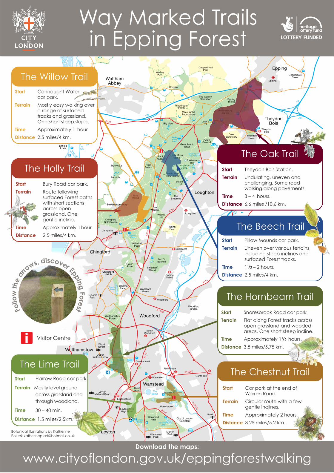
Way Marked Trailsin Epping Forest

Visitor Centre

www.cityoflondon.gov.uk/eppingforestwalking

Start Pillow Mounds car park.

Terrain Uneven over various terrains,including steep inclines andsurfaced Forest tracks.

Time 11 /2 – 2 hours.

Distance 2.5 miles/4 km.

The Beech Trail

Start Bury Road car park.

Terrain Route followingsurfaced Forest pathswith short sectionsacross opengrassland. One gentle incline.

Time Approximately 1 hour.

Distance 2.5 miles/4 km.

The Holly Trail Start Theydon Bois Station.

Terrain Undulating, uneven andchallenging. Some roadwalking along pavements.

Time 3 – 4 hours.

Distance 6.6 miles /10.6 km.

The Oak Trail

The Lime TrailStart Harrow Road car park.

Terrain Mostly level groundacross grassland and through woodland.

Time 30 – 40 min.

Distance 1.5 miles/2.5km.

Start Car park at the end of Warren Road.

Terrain Circular route with a fewgentle inclines.

Time Approximately 2 hours.

Distance 3.25 miles/5.2 km.

The Chestnut Trail

Start Snaresbrook Road car park

Terrain Flat along Forest tracks acrossopen grassland and woodedareas. One short steep incline.

Time Approximately 11 /2 hours.

Distance 3.5 miles/5.75 km.

The Hornbeam Trail

Download the maps:

Follo

wth

ear

rows, discover Epping

Fore

st

Start Connaught Water car park.

Terrain Mostly easy walking overa range of surfacedtracks and grassland. One short steep slope.

Time Approximately 1 hour.

Distance 2.5 miles/4 km.

The Willow Trail