Embed Size (px)
Citation preview
A C C O M P L I S H M E N T R E P O R T 1
Accomplishment Report
F E B R U A R Y 2 0 1 6
“Managing Water Resources in Arid and Semi Arid Regions of Latin America and Caribbean” (MWAR –LAC)

A C C O M P L I S H M E N T R E P O R T2
A C C O M P L I S H M E N T R E P O R T 1
Accomplishment Report
F E B R U A R Y 2 0 1 6
“Managing Water Resources in Arid and Semi Arid Regions of Latin America and Caribbean” (MWAR –LAC)
A C C O M P L I S H M E N T R E P O R T2
© UNESCO/Koen Verbist
© F
ranc
isco
Fio
ndel
la /
IRI
A C C O M P L I S H M E N T R E P O R T 3
C o n t e n t s
Preface ................................................................................................................................ 4
The Challenge of Water Management in Drylands ..............................................................7
Managing Water under Uncertain Climate Projections ......................................................7
Towards an Integrated Drought Risk Management .............................................................9
National Drought Observatories ........................................................................................9
The Chilean Agroclimatic Observatory ...........................................................................9
The Peruvian Drought Observatory .............................................................................. 12
Honduras .................................................................................................................... 15
The Latin American Flood and Drought Monitor ............................................................... 15
The Latin American and Caribbean Drought Atlas............................................................ 18
The Online Drought Atlas ................................................................................................ 20
Building capacities to face water resources challenges ...................................................22
International Symposium on Drought Management Tools ................................................22
Symposium and Professional Training on Andean Hydrology ..........................................23
Soil and Water Management in the Bolivian Altiplano ......................................................25
Deficit Irrigation Production Systems in the Bolivian Altiplano .....................................26
Conservation of Soil and Water in Andes Countries Outreach Activities .......................26
The Latin American School of Soil Physics .......................................................................27
Supporting effective drought risk management in vulnerable catchments of Chile ..........27
Outreach and Dissemination .............................................................................................29
The Dryland Expert Database ..........................................................................................29
The MWAR-LAC Project Website ..................................................................................... 30
The MWAR-LAC Newsletter ............................................................................................. 31
MWAR-LAC Brochures ..................................................................................................... 31
The MWAR-LAC Project in Numbers ..................................................................................32
Detailed Overview of Activities and Partners ....................................................................33
References ........................................................................................................................ 45
A C C O M P L I S H M E N T R E P O R T4
Preface
Water management in arid and semi-arid regions has been a key focus area of the International Hydrological Programme since its inception in 1975, with its roots dating back to the UNESCO ‘Arid Zones Programme’ in 1955. The challenges to address water management have evolved over time, but novel solutions are still required to face current issues in the drylands worldwide. Therefore, UNESCO-IHP created a specific arid region programme in December 2004, establishing the Global Network on Water Resources Management in Arid and Semi-arid Zones or G-WADI.
The project ‘Managing Water Resources in semi-Arid Regions of Latin America and the Caribbean’ (MWAR-LAC) was launched in 2012 to strengthen those objectives and to provide to Member States the tools required to tackle current challenges in its drylands. As evidence is mounting that climate change is already affecting those regions, building resilience into dryland communities is an essential task to lower the vulnerability to current and future water-related hazards and to strengthen their adaptive capacity. Thanks to the financial support from the Flemish Government and the Flanders UNESCO Science Trust Fund (FUST), the project was able to engage over 21 local and international partners from 11 different countries inside and outside the region collaborating to support the projects’ objectives.
This international collaboration has achieved several milestones as presented in the following accomplishment report. These include the showcasing of effective pathways for integrated drought management in two pilot countries, by strengthening the capacity of the local governments to address drought hazards more efficiently and pro-actively. As droughts are occurring more frequently in the region, affecting 6.6 million people in 2015, the lessons learnt in this project have the potential to be replicated in other countries in the region and worldwide. But also more regional solutions were implemented, such as the Latin American and Caribbean Drought Atlas, as well as the Latin American and Caribbean Flood and Drought Monitor, that provides monitoring and early warning capacities for all countries in the region.
The project also strengthened the capacities of local stakeholders to address the multi-faceted aspects of water management in drylands, including adaptive water capacity, water-energy nexus, groundwater management, drought management, soil and water conservation and remote sensing for water management. Through multiple capacity buildings more than 324 participants from 26 countries in the region could be trained. Through all these activities, the project was also able to contribute effectively to the objectives of the VIIIth phase of UNESCO-IHP (2014-2021): Water Security - Responses to Local, Regional, and Global Challenges, within the framework of the G-WADI programme.
You will learn more about the accomplishments of the MWAR-LAC project in the following report, providing a baseline for other initiatives to start from and an example of regional collaboration to achieve water security in drylands of Latin America and the Caribbean.
I would like sincerely to thank the Government of Flanders for providing funds to the project. Similarly, I would like to thank all stakeholders including scientists, participating countries and colleagues involved in the project.
Blanca Jiménez-Cisneros, Director, Water Sciences DivisionSecretaryInternational Hydrological Programme (IHP) UNESCO
A C C O M P L I S H M E N T R E P O R T 5
Quotes from the Project partners
Claudio Ternicier González, Subsecretary for Agriculture of Chile
“ Since its development in 2013, the Agroclimatic Observatory has contributed to the monitoring and early warning of drought hazards affecting Chilean Agriculture. Through capacity building and intensive trainings, more than 600 local stakeholders could be reached in the whole country, providing them with tools to make better, climate-informed decisions. The Observatory has also served as an example for other countries in the region of Latin America.
These developments in collaboration with UNESCO and with support from the Flemish Government have also contributed to strengthen inter-institutional collaboration, integrating different efforts across sectors to address agricultural drought hazards. Therefore, we look forward to continue and to enhance our collaboration with UNESCO to strengthen the current drought risk management for Chile, considering the additional challenges posed by climate change impacts.”
Juan Carlos Sevilla Gildemeister, Head of the National Water Authority, Peru
“ Despite the fact that droughts are a recurring problem in the south of our country, little development has been realized for its monitoring and study. In this sense, the National Drought Observatory is an important initiative, as it not only allows to monitor drought in the country and its impacts on society; but also allows us to articulate with other sectors for its implementation and operation. In this sense, the support we have received from UNESCO through technical capacity building has been essential, given the limited experience that is available in Peru regarding drought monitoring and management.
The implementation of the Observatory has allowed to initiate a process of articulation between institutes related to the management of water resources, disaster risk reduction, production and academic institutes. Based on this work, we aim to count with a completely functional tool that allows us to reduce the environmental and socio-economical vulnerability, and increase the response capacity and recovery from those events.”
Carlos Estévez Valencia, Director of the Chilean Water Authority
“ Over the last decade, the challenges of managing water resources in Chile have significantly increased, due to longer and more intense droughts, higher water demands, reducing snow levels and receding glaciers, as well as the occurrence of devastating flood events. To adequately address these changes new tools and insights need to be implemented, involving knowledge and latest developments available worldwide.
In this effort, we acknowledge the support the MWAR-LAC project has provided the DGA over the last three years to strengthen our capacities to monitor droughts, to provide the building blocks to build a national flood early warning system and to identify the potential impacts of climate change on water resources management in Chile, as well as to support the science-policy dialogue on the impact of glacier melt on water resources in the Andean region. As the decisions taken today will shape our capacity to address the impacts of climate change in the near future, these supports will prove to be essential to safeguard water security in Chile in the decades to come.”
A C C O M P L I S H M E N T R E P O R T6
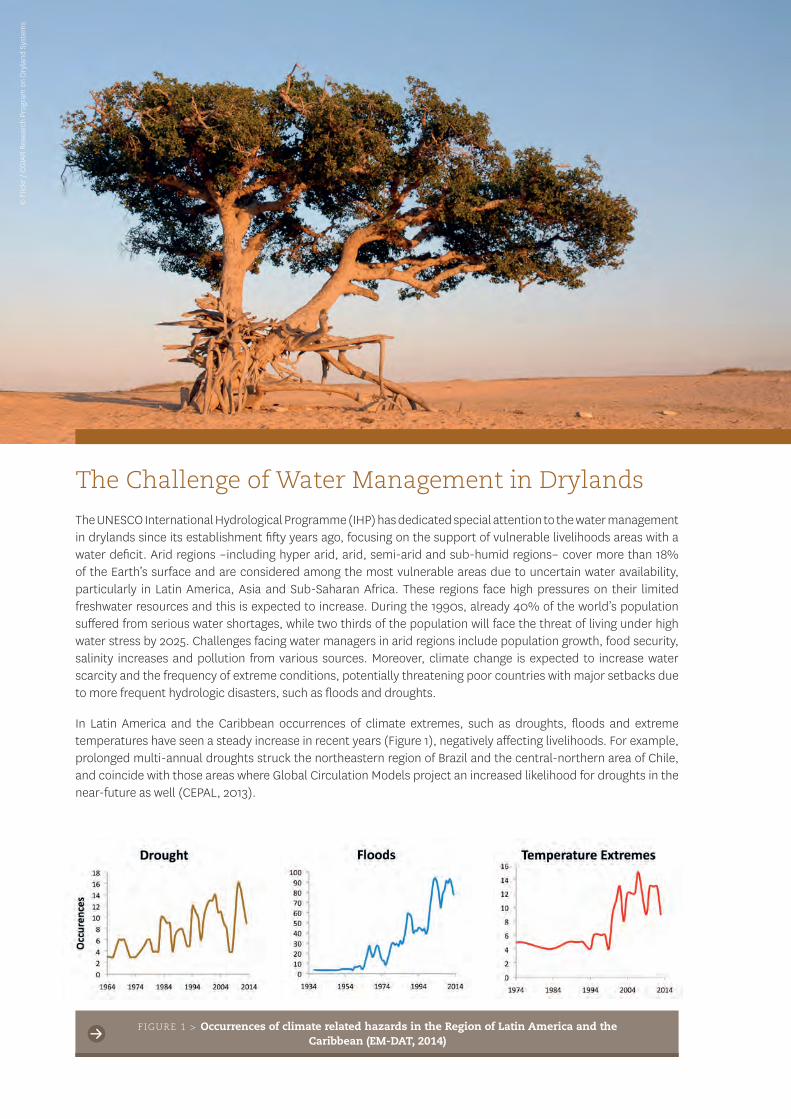
The Challenge of Water Management in Drylands
The UNESCO International Hydrological Programme (IHP) has dedicated special attention to the water management in drylands since its establishment fifty years ago, focusing on the support of vulnerable livelihoods areas with a water deficit. Arid regions –including hyper arid, arid, semi-arid and sub-humid regions– cover more than 18% of the Earth’s surface and are considered among the most vulnerable areas due to uncertain water availability, particularly in Latin America, Asia and Sub-Saharan Africa. These regions face high pressures on their limited freshwater resources and this is expected to increase. During the 1990s, already 40% of the world’s population suffered from serious water shortages, while two thirds of the population will face the threat of living under high water stress by 2025. Challenges facing water managers in arid regions include population growth, food security, salinity increases and pollution from various sources. Moreover, climate change is expected to increase water scarcity and the frequency of extreme conditions, potentially threatening poor countries with major setbacks due to more frequent hydrologic disasters, such as floods and droughts.
In Latin America and the Caribbean occurrences of climate extremes, such as droughts, floods and extreme temperatures have seen a steady increase in recent years (Figure 1), negatively affecting livelihoods. For example, prolonged multi-annual droughts struck the northeastern region of Brazil and the central-northern area of Chile, and coincide with those areas where Global Circulation Models project an increased likelihood for droughts in the near-future as well (CEPAL, 2013).
FIGURE 1 > Occurrences of climate related hazards in the Region of Latin America and the Caribbean (EM-DAT, 2014)
© F
lickr
/ C
GIA
R R
esea
rch
Prog
ram
on
Dry
land
Sys
tem
s
A C C O M P L I S H M E N T R E P O R T 7
In this context, managing water is one of the greatest and more urgent challenges, which requires an accurate assessment of the available and renewable water resources. However, such an assessment is especially difficult in arid regions, since the science base is limited, data are scarce and humid zone experience is inappropriate. Therefore, improved scientific understanding, co-operation and data sharing are fundamental to facilitate ways of better water governance and to reach integrated management of water resources in arid and semi-arid regions.
To contribute to these efforts, the project ‘Managing Water Resources in Arid and Semi-Arid Regions Of Latin America and the Caribbean’ (MWAR-LAC) aimed at improving the quality of life of local communities in arid and semi-arid environments in Latin America and the Caribbean, through a reduction in the vulnerability of water resources systems to global changes and an improvement in water governance based on sound scientific knowledge.
The project focussed thereby on three different aspects. The first objective was to include climate information in water management by generating and disseminating climate information systems for decision making on water management. A second aspect focussed on capacity building and networking of technical, academic and professional stakeholders to improve water use efficiency and to engage with the political sector to identify solutions to manage water-related disasters. A third component focussed on increased water governance in watersheds in order to strengthen integrated water resources management.
The implementation of the different components of the MWAR-LAC project have led to a large set of activities during the period 2012-2016 in collaboration with a large number of local and international partners. In this accomplishment report, a short overview of project outcomes and deliverables is presented, as well as the impact of the project in the region of Latin America and the Caribbean.
Managing Water under Uncertain Climate Projections
To support adaptation to climate change in the Region of Latin America and the Caribbean, an increased awareness on the impact of climate change on water resources is crucial. This enables to define adaptation strategies to expected changes in water resources under the modified climatic conditions. These strategies focus on three likely areas for action: water shortage, excess rainfall and increase in the frequency of extreme events.
To initiate this process, a first international workshop ´Development of near-term climate scenarios (2020-2035) for vulnerable watersheds to climatic variability at the interanual, decadal and climate change time scales´ was held in August 2014 in La Serena, Chile. It concerned an intensive capacity building of professionals on the application of Near Term Climate Change Scenario Analysis for applications in hydrology and drought vulnerability analysis, reflected in four pilot countries (Chile, Bolivia, Peru and Colombia). The selected participants were especially chosen for their strong linkage with end users, governmental agencies, water managers, research centers and universities in their respective countries. By pooling this group of interdisciplinary experts, collaboration across the region was strengthened with respect to Integrated Water Resources Management under future climate scenarios.
During the workshop, various tools and algorithms, necessary to identify climate variability on different time scales, were demonstrated. In this effort, a clear separation between natural variability and climate change was made, to identify how this change impacts the normal conditions that communities are used to. A first step therefore consisted in the identification of natural climate variability, looking at annual variations, but also identifying influences of decadal climatic oscillations. Examining the climate records of vulnerable basins, the different components of natural variability were identified.
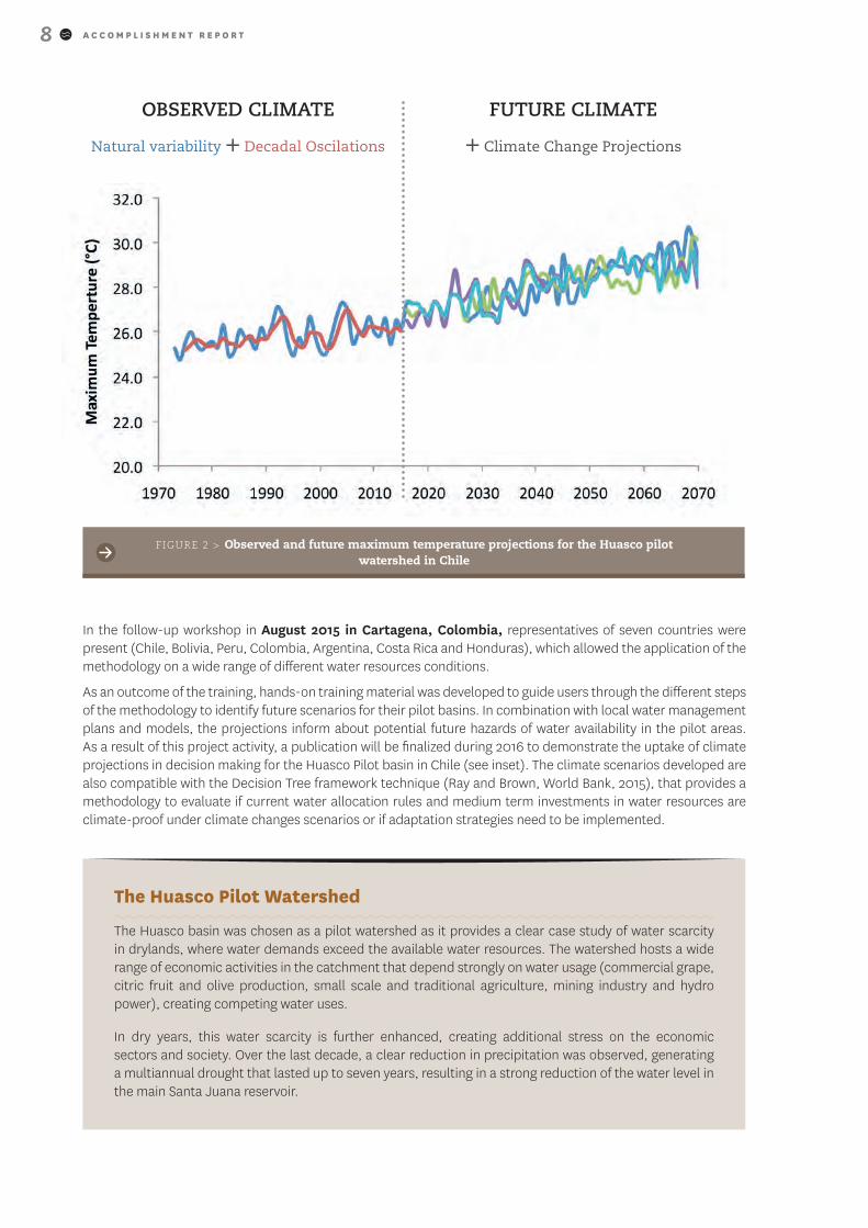
In a second step, forty-two Global Circulation Models (GCMs) were applied to identify the projected changes in temperature and precipitation in the pilot basins. Figure 2 presents the observed and projected maximum temperature values, obtained for the RCP 8.5 scenario (a scenario of comparatively high greenhouse gas emissions) as projected by the GCMs using the SimGen model (Greene et al., 2012).
A C C O M P L I S H M E N T R E P O R T8
OBSERVED CLIMATE
Natural variability + Decadal Oscilations
FUTURE CLIMATE
+ Climate Change Projections
In the follow-up workshop in August 2015 in Cartagena, Colombia, representatives of seven countries were present (Chile, Bolivia, Peru, Colombia, Argentina, Costa Rica and Honduras), which allowed the application of the methodology on a wide range of different water resources conditions.
As an outcome of the training, hands-on training material was developed to guide users through the different steps of the methodology to identify future scenarios for their pilot basins. In combination with local water management plans and models, the projections inform about potential future hazards of water availability in the pilot areas. As a result of this project activity, a publication will be finalized during 2016 to demonstrate the uptake of climate projections in decision making for the Huasco Pilot basin in Chile (see inset). The climate scenarios developed are also compatible with the Decision Tree framework technique (Ray and Brown, World Bank, 2015), that provides a methodology to evaluate if current water allocation rules and medium term investments in water resources are climate-proof under climate changes scenarios or if adaptation strategies need to be implemented.
The Huasco Pilot Watershed
The Huasco basin was chosen as a pilot watershed as it provides a clear case study of water scarcity in drylands, where water demands exceed the available water resources. The watershed hosts a wide range of economic activities in the catchment that depend strongly on water usage (commercial grape, citric fruit and olive production, small scale and traditional agriculture, mining industry and hydro power), creating competing water uses.
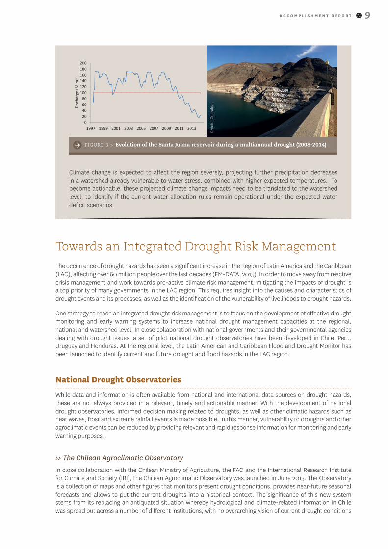
In dry years, this water scarcity is further enhanced, creating additional stress on the economic sectors and society. Over the last decade, a clear reduction in precipitation was observed, generating a multiannual drought that lasted up to seven years, resulting in a strong reduction of the water level in the main Santa Juana reservoir.
FIGURE 2 > Observed and future maximum temperature projections for the Huasco pilot watershed in Chile
A C C O M P L I S H M E N T R E P O R T 9
Towards an Integrated Drought Risk Management
The occurrence of drought hazards has seen a significant increase in the Region of Latin America and the Caribbean (LAC), affecting over 60 million people over the last decades (EM-DATA, 2015). In order to move away from reactive crisis management and work towards pro-active climate risk management, mitigating the impacts of drought is a top priority of many governments in the LAC region. This requires insight into the causes and characteristics of drought events and its processes, as well as the identification of the vulnerability of livelihoods to drought hazards.
One strategy to reach an integrated drought risk management is to focus on the development of effective drought monitoring and early warning systems to increase national drought management capacities at the regional, national and watershed level. In close collaboration with national governments and their governmental agencies dealing with drought issues, a set of pilot national drought observatories have been developed in Chile, Peru, Uruguay and Honduras. At the regional level, the Latin American and Caribbean Flood and Drought Monitor has been launched to identify current and future drought and flood hazards in the LAC region.
National Drought Observatories
While data and information is often available from national and international data sources on drought hazards, these are not always provided in a relevant, timely and actionable manner. With the development of national drought observatories, informed decision making related to droughts, as well as other climatic hazards such as heat waves, frost and extreme rainfall events is made possible. In this manner, vulnerability to droughts and other agroclimatic events can be reduced by providing relevant and rapid response information for monitoring and early warning purposes.
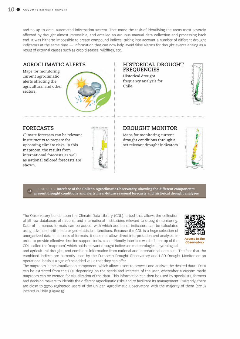
›> The Chilean Agroclimatic Observatory
In close collaboration with the Chilean Ministry of Agriculture, the FAO and the International Research Institute for Climate and Society (IRI), the Chilean Agroclimatic Observatory was launched in June 2013. The Observatory is a collection of maps and other figures that monitors present drought conditions, provides near-future seasonal forecasts and allows to put the current droughts into a historical context. The significance of this new system stems from its replacing an antiquated situation whereby hydrological and climate-related information in Chile was spread out across a number of different institutions, with no overarching vision of current drought conditions
Climate change is expected to affect the region severely, projecting further precipitation decreases in a watershed already vulnerable to water stress, combined with higher expected temperatures. To become actionable, these projected climate change impacts need to be translated to the watershed level, to identify if the current water allocation rules remain operational under the expected water deficit scenarios.
FIGURE 3 > Evolution of the Santa Juana reservoir during a multiannual drought (2008-2014)
© V
icto
r G
onza
lez
A C C O M P L I S H M E N T R E P O R T10
and no up to date, automated information system. That made the task of identifying the areas most severely affected by drought almost impossible, and entailed an arduous manual data collection and processing back end. It was hitherto impossible to create compound indices, taking into account a number of different drought indicators at the same time — information that can now help avoid false alarms for drought events arising as a result of external causes such as crop diseases, wildfires, etc.
AGROCLIMATIC ALERTSMaps for monitoring current agroclimatic alerts affecting the agricultural and other sectors.
HISTORICAL DROUGHT FREQUENCIESHistorical drought frequency analysis for Chile.
FORECASTSClimate forecasts can be relevant instruments to prepare for upcoming climate risks. In this maproom, the results from international forecasts as well as national tailored forecasts are shown.
DROUGHT MONITORMaps for monitoring current drought conditions through a set relevant drought indicators.
FIGURE 4 > Interface of the Chilean Agroclimatic Observatory, showing the different components: present drought conditions and alerts, near-future seasonal forecasts and historical drought analyses
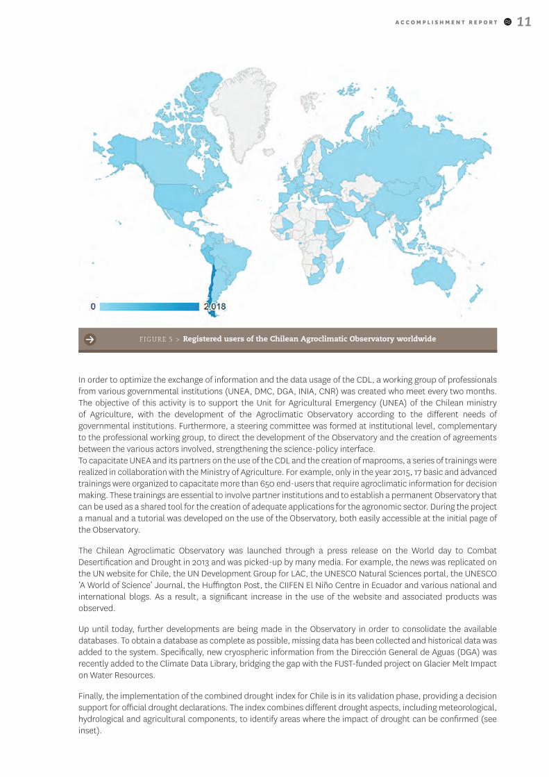
The Observatory builds upon the Climate Data Library (CDL), a tool that allows the collection of all raw databases of national and international institutions relevant to drought monitoring. Data of numerous formats can be added, with which additional indicators can be calculated using advanced arithmetic or geo-statistical functions. Because the CDL is a huge selection of unorganized data in all sorts of formats, it does not allow direct interpretation and analysis. In order to provide effective decision support tools, a user friendly interface was built on top of the CDL, called the ‘maproom’, which holds relevant drought indices on meteorological, hydrological and agricultural drought, and combines information from national and international data sets. The fact that the combined indices are currently used by the European Drought Observatory and USD Drought Monitor on an operational basis is a sign of the added value that they can offer. The maproom is the visualization component, which allows users to process and analyze the desired data. Data can be extracted from the CDL depending on the needs and interests of the user, whereafter a custom made maproom can be created for visualization of the data. This information can then be used by specialists, farmers and decision makers to identify the different agroclimatic risks and to facilitate its management. Currently, there are close to 3300 registered users of the Chilean Agroclimatic Observatory, with the majority of them (2018) located in Chile (Figure 5).
Access to the Observatory
A C C O M P L I S H M E N T R E P O R T 11
In order to optimize the exchange of information and the data usage of the CDL, a working group of professionals from various governmental institutions (UNEA, DMC, DGA, INIA, CNR) was created who meet every two months. The objective of this activity is to support the Unit for Agricultural Emergency (UNEA) of the Chilean ministry of Agriculture, with the development of the Agroclimatic Observatory according to the different needs of governmental institutions. Furthermore, a steering committee was formed at institutional level, complementary to the professional working group, to direct the development of the Observatory and the creation of agreements between the various actors involved, strengthening the science-policy interface. To capacitate UNEA and its partners on the use of the CDL and the creation of maprooms, a series of trainings were realized in collaboration with the Ministry of Agriculture. For example, only in the year 2015, 17 basic and advanced trainings were organized to capacitate more than 650 end-users that require agroclimatic information for decision making. These trainings are essential to involve partner institutions and to establish a permanent Observatory that can be used as a shared tool for the creation of adequate applications for the agronomic sector. During the project a manual and a tutorial was developed on the use of the Observatory, both easily accessible at the initial page of the Observatory.
The Chilean Agroclimatic Observatory was launched through a press release on the World day to Combat Desertification and Drought in 2013 and was picked-up by many media. For example, the news was replicated on the UN website for Chile, the UN Development Group for LAC, the UNESCO Natural Sciences portal, the UNESCO ‘A World of Science’ Journal, the Huffington Post, the CIIFEN El Niño Centre in Ecuador and various national and international blogs. As a result, a significant increase in the use of the website and associated products was observed.
Up until today, further developments are being made in the Observatory in order to consolidate the available databases. To obtain a database as complete as possible, missing data has been collected and historical data was added to the system. Specifically, new cryospheric information from the Dirección General de Aguas (DGA) was recently added to the Climate Data Library, bridging the gap with the FUST-funded project on Glacier Melt Impact on Water Resources.
Finally, the implementation of the combined drought index for Chile is in its validation phase, providing a decision support for official drought declarations. The index combines different drought aspects, including meteorological, hydrological and agricultural components, to identify areas where the impact of drought can be confirmed (see inset).
FIGURE 5 > Registered users of the Chilean Agroclimatic Observatory worldwide
A C C O M P L I S H M E N T R E P O R T12
›> The Peruvian Drought Observatory
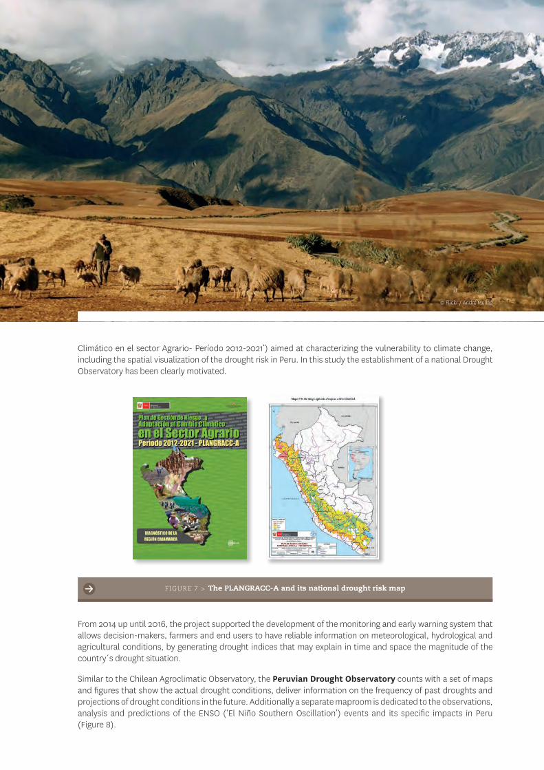
Similar as in the case of Chile, a lack of drought monitoring and early warning capacities was identified by the Peruvian authorities. As part of the MWAR-LAC project, support was provided to develop the necessary tools to identify drought hazards in Peru. The work was centered on the integration of the different data sources generated by the governmental institutions and universities. A real need was identified to centralize the different data sources, in order to allow the evaluation of the current drought conditions and the identification of the most vulnerable areas to drought, especially under El Niño and La Niña conditions.
A steering committee was established in 2014 to oversee the implementation plan that was adopted during the first meeting, integrating more than 20 different governmental and research institutes and ministries, building upon already existing frameworks, such as the National Climate Change Adaptation Plan that was elaborated by the Ministry of Agriculture (Figure 7). This PLANGRACC-A (‘Plan de Gestión de Riesgo y Adaptación al Cambio
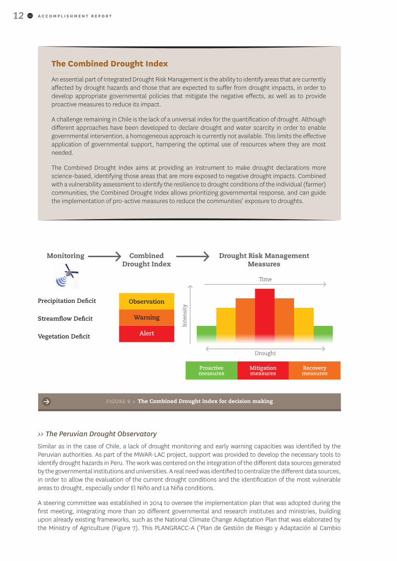
The Combined Drought Index
An essential part of Integrated Drought Risk Management is the ability to identify areas that are currently affected by drought hazards and those that are expected to suffer from drought impacts, in order to develop appropriate governmental policies that mitigate the negative effects, as well as to provide proactive measures to reduce its impact.
A challenge remaining in Chile is the lack of a universal index for the quantification of drought. Although different approaches have been developed to declare drought and water scarcity in order to enable governmental intervention, a homogeneous approach is currently not available. This limits the effective application of governmental support, hampering the optimal use of resources where they are most needed.
The Combined Drought Index aims at providing an instrument to make drought declarations more science-based, identifying those areas that are more exposed to negative drought impacts. Combined with a vulnerability assessment to identify the resilience to drought conditions of the individual (farmer) communities, the Combined Drought Index allows prioritizing governmental response, and can guide the implementation of pro-active measures to reduce the communities’ exposure to droughts.
Drought Risk Management Measures
Time
Monitoring Combined Drought Index
Drought
Inte
nsi
ty
Proactive measures
Mitigation measures
Recovery measures
Observation
Warning
Alert
Precipitation Deficit
Streamflow Deficit
Vegetation Deficit
FIGURE 6 > The Combined Drought Index for decision making
A C C O M P L I S H M E N T R E P O R T 13
Climático en el sector Agrario- Período 2012-2021’) aimed at characterizing the vulnerability to climate change, including the spatial visualization of the drought risk in Peru. In this study the establishment of a national Drought Observatory has been clearly motivated.
FIGURE 7 > The PLANGRACC-A and its national drought risk map
From 2014 up until 2016, the project supported the development of the monitoring and early warning system that allows decision-makers, farmers and end users to have reliable information on meteorological, hydrological and agricultural conditions, by generating drought indices that may explain in time and space the magnitude of the country´s drought situation.
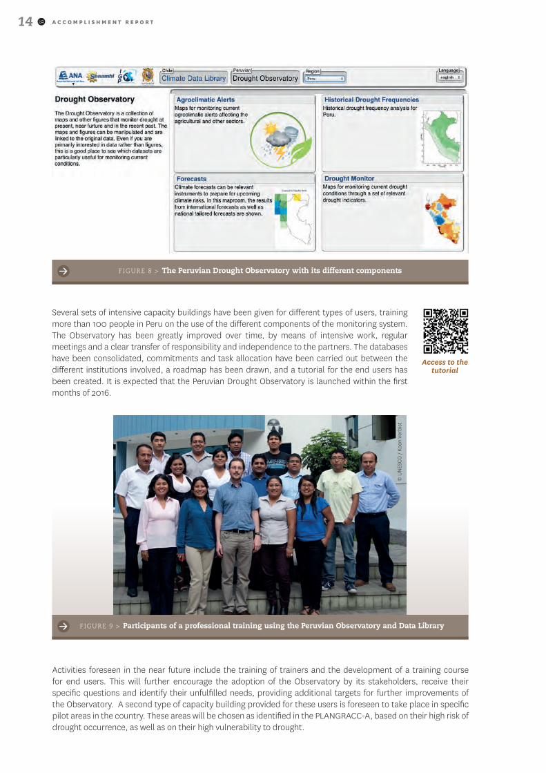
Similar to the Chilean Agroclimatic Observatory, the Peruvian Drought Observatory counts with a set of maps and figures that show the actual drought conditions, deliver information on the frequency of past droughts and projections of drought conditions in the future. Additionally a separate maproom is dedicated to the observations, analysis and predictions of the ENSO (‘El Niño Southern Oscillation’) events and its specific impacts in Peru (Figure 8).
© Flickr / André Mellag
A C C O M P L I S H M E N T R E P O R T14
FIGURE 8 > The Peruvian Drought Observatory with its different components
Several sets of intensive capacity buildings have been given for different types of users, training more than 100 people in Peru on the use of the different components of the monitoring system. The Observatory has been greatly improved over time, by means of intensive work, regular meetings and a clear transfer of responsibility and independence to the partners. The databases have been consolidated, commitments and task allocation have been carried out between the different institutions involved, a roadmap has been drawn, and a tutorial for the end users has been created. It is expected that the Peruvian Drought Observatory is launched within the first months of 2016.
Access to the tutorial
Activities foreseen in the near future include the training of trainers and the development of a training course for end users. This will further encourage the adoption of the Observatory by its stakeholders, receive their specific questions and identify their unfulfilled needs, providing additional targets for further improvements of the Observatory. A second type of capacity building provided for these users is foreseen to take place in specific pilot areas in the country. These areas will be chosen as identified in the PLANGRACC-A, based on their high risk of drought occurrence, as well as on their high vulnerability to drought.
FIGURE 9 > Participants of a professional training using the Peruvian Observatory and Data Library
© U
NES
CO
/ K
oen
Verb
ist
A C C O M P L I S H M E N T R E P O R T 15
Access to the Monitor
Similar to the work developed for Chile, a clear need was established to develop a locally-calibrated Combined Drought Index for decision making purposes and pro-active drought management. Since the Observatory is integrated into the decision making framework of the National Water Resources Information System (SNIRH) at the Autoridad Nacional del Agua (ANA), the Observatory will eventually play a central role in the implementation of drought measures in the areas affected.
›> Honduras
A more recent development is the demonstrated interest from Honduras to start developing a national Drought Observatory. To strengthen the linkages with the on-going development of Drought Observatories in Chile and Peru, Honduras sent a self-funded delegation of 10 representatives from national governmental agencies and international organizations to learn about the Chilean experience and to identify possible collaboration options.
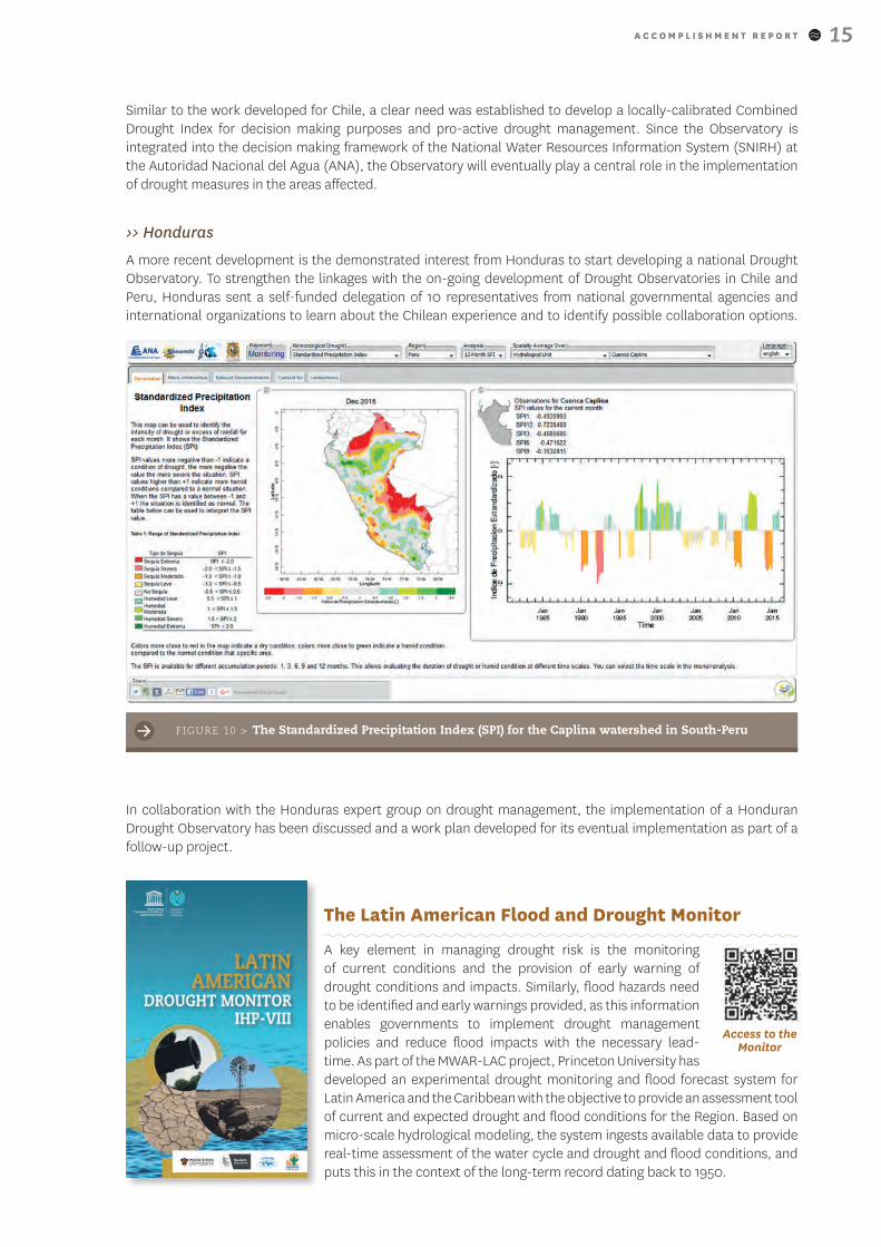
FIGURE 10 > The Standardized Precipitation Index (SPI) for the Caplina watershed in South-Peru
In collaboration with the Honduras expert group on drought management, the implementation of a Honduran Drought Observatory has been discussed and a work plan developed for its eventual implementation as part of a follow-up project.
The Latin American Flood and Drought Monitor
A key element in managing drought risk is the monitoring of current conditions and the provision of early warning of drought conditions and impacts. Similarly, flood hazards need to be identified and early warnings provided, as this information enables governments to implement drought management policies and reduce flood impacts with the necessary lead-time. As part of the MWAR-LAC project, Princeton University has developed an experimental drought monitoring and flood forecast system for Latin America and the Caribbean with the objective to provide an assessment tool of current and expected drought and flood conditions for the Region. Based on micro-scale hydrological modeling, the system ingests available data to provide real-time assessment of the water cycle and drought and flood conditions, and puts this in the context of the long-term record dating back to 1950.
A C C O M P L I S H M E N T R E P O R T16
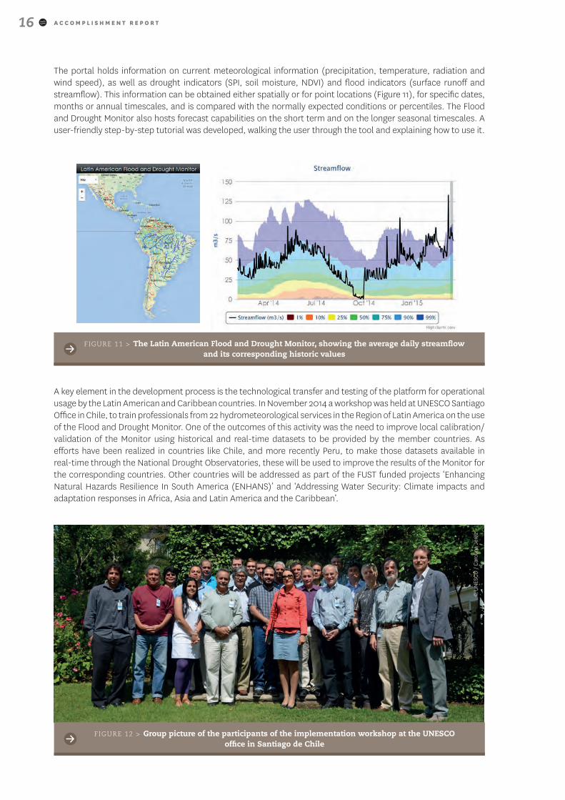
The portal holds information on current meteorological information (precipitation, temperature, radiation and wind speed), as well as drought indicators (SPI, soil moisture, NDVI) and flood indicators (surface runoff and streamflow). This information can be obtained either spatially or for point locations (Figure 11), for specific dates, months or annual timescales, and is compared with the normally expected conditions or percentiles. The Flood and Drought Monitor also hosts forecast capabilities on the short term and on the longer seasonal timescales. A user-friendly step-by-step tutorial was developed, walking the user through the tool and explaining how to use it.
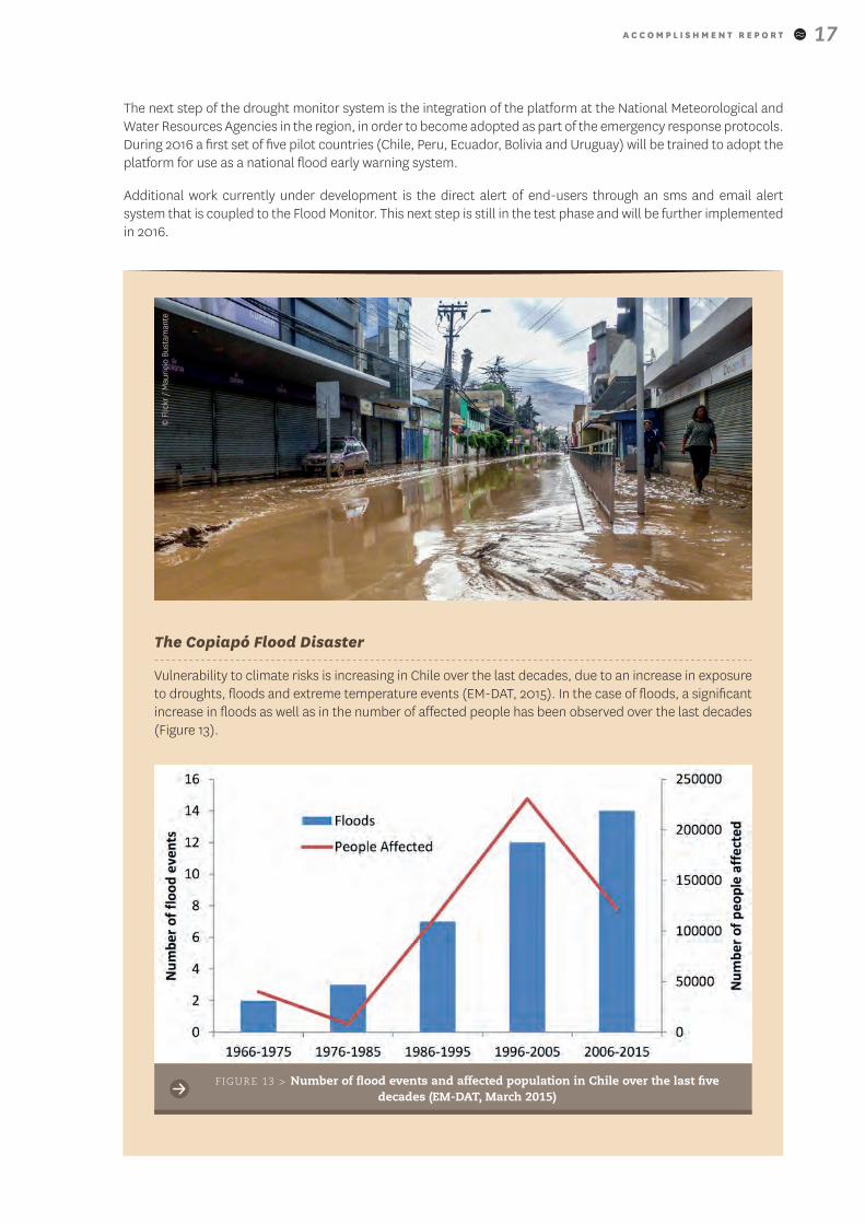
A key element in the development process is the technological transfer and testing of the platform for operational usage by the Latin American and Caribbean countries. In November 2014 a workshop was held at UNESCO Santiago Office in Chile, to train professionals from 22 hydrometeorological services in the Region of Latin America on the use of the Flood and Drought Monitor. One of the outcomes of this activity was the need to improve local calibration/validation of the Monitor using historical and real-time datasets to be provided by the member countries. As efforts have been realized in countries like Chile, and more recently Peru, to make those datasets available in real-time through the National Drought Observatories, these will be used to improve the results of the Monitor for the corresponding countries. Other countries will be addressed as part of the FUST funded projects ‘Enhancing Natural Hazards Resilience In South America (ENHANS)’ and ‘Addressing Water Security: Climate impacts and adaptation responses in Africa, Asia and Latin America and the Caribbean’.
FIGURE 11 > The Latin American Flood and Drought Monitor, showing the average daily streamflow and its corresponding historic values
FIGURE 12 > Group picture of the participants of the implementation workshop at the UNESCO office in Santiago de Chile
© U
NES
CO
/ C
arol
ina
Jere
z
A C C O M P L I S H M E N T R E P O R T 17
The next step of the drought monitor system is the integration of the platform at the National Meteorological and Water Resources Agencies in the region, in order to become adopted as part of the emergency response protocols. During 2016 a first set of five pilot countries (Chile, Peru, Ecuador, Bolivia and Uruguay) will be trained to adopt the platform for use as a national flood early warning system.
Additional work currently under development is the direct alert of end-users through an sms and email alert system that is coupled to the Flood Monitor. This next step is still in the test phase and will be further implemented in 2016.
The Copiapó Flood Disaster
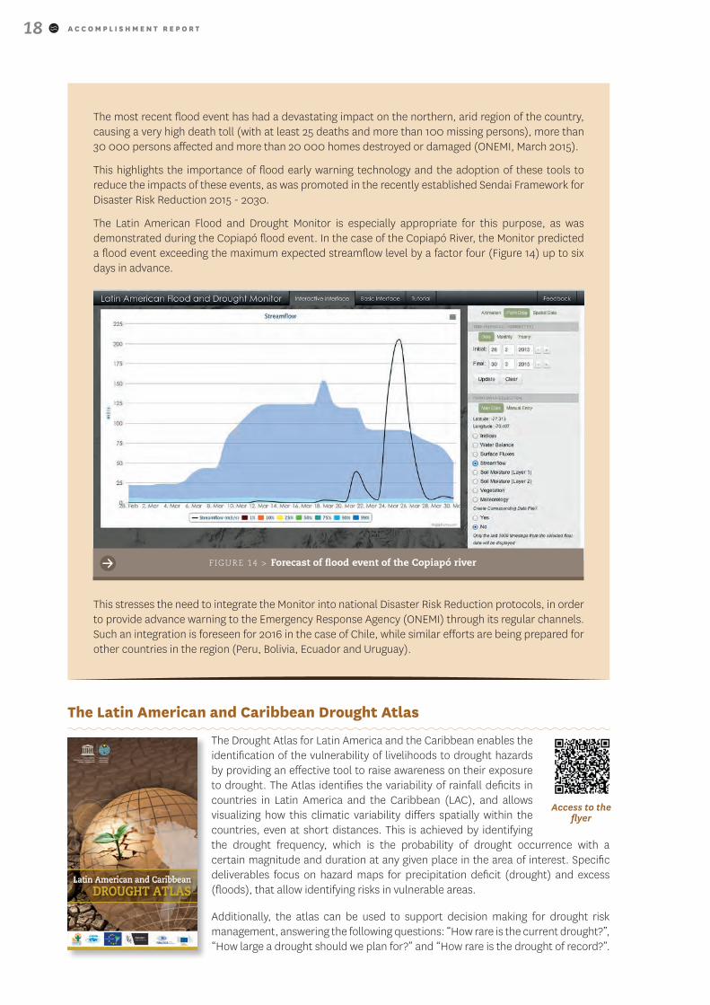
Vulnerability to climate risks is increasing in Chile over the last decades, due to an increase in exposure to droughts, floods and extreme temperature events (EM-DAT, 2015). In the case of floods, a significant increase in floods as well as in the number of affected people has been observed over the last decades (Figure 13).
FIGURE 13 > Number of flood events and affected population in Chile over the last five decades (EM-DAT, March 2015)
© F
lickr
/ M
auri
cio
Bust
aman
te
A C C O M P L I S H M E N T R E P O R T18
Access to the flyer
The most recent flood event has had a devastating impact on the northern, arid region of the country, causing a very high death toll (with at least 25 deaths and more than 100 missing persons), more than 30 000 persons affected and more than 20 000 homes destroyed or damaged (ONEMI, March 2015).
This highlights the importance of flood early warning technology and the adoption of these tools to reduce the impacts of these events, as was promoted in the recently established Sendai Framework for Disaster Risk Reduction 2015 - 2030.
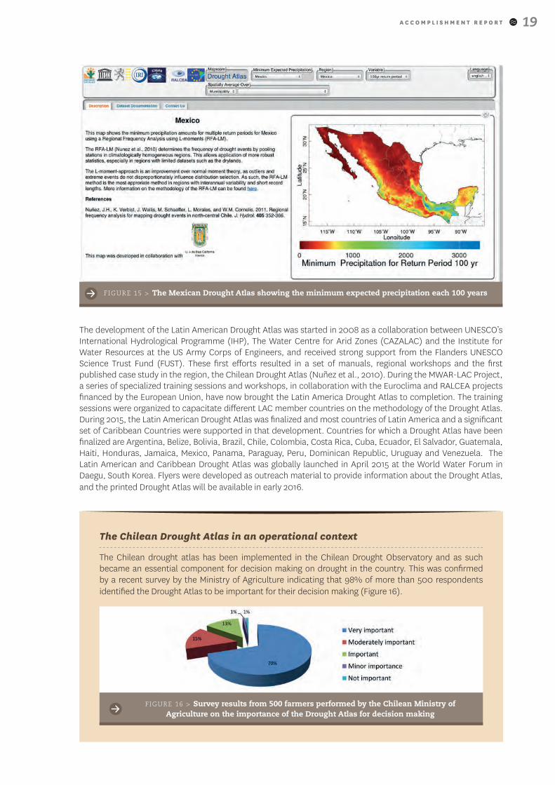
The Latin American Flood and Drought Monitor is especially appropriate for this purpose, as was demonstrated during the Copiapó flood event. In the case of the Copiapó River, the Monitor predicted a flood event exceeding the maximum expected streamflow level by a factor four (Figure 14) up to six days in advance.
This stresses the need to integrate the Monitor into national Disaster Risk Reduction protocols, in order to provide advance warning to the Emergency Response Agency (ONEMI) through its regular channels. Such an integration is foreseen for 2016 in the case of Chile, while similar efforts are being prepared for other countries in the region (Peru, Bolivia, Ecuador and Uruguay).
FIGURE 14 > Forecast of flood event of the Copiapó river
The Latin American and Caribbean Drought Atlas
The Drought Atlas for Latin America and the Caribbean enables the identification of the vulnerability of livelihoods to drought hazards by providing an effective tool to raise awareness on their exposure to drought. The Atlas identifies the variability of rainfall deficits in countries in Latin America and the Caribbean (LAC), and allows visualizing how this climatic variability differs spatially within the countries, even at short distances. This is achieved by identifying the drought frequency, which is the probability of drought occurrence with a certain magnitude and duration at any given place in the area of interest. Specific deliverables focus on hazard maps for precipitation deficit (drought) and excess (floods), that allow identifying risks in vulnerable areas.
Additionally, the atlas can be used to support decision making for drought risk management, answering the following questions: “How rare is the current drought?”, “How large a drought should we plan for?” and “How rare is the drought of record?”.
A C C O M P L I S H M E N T R E P O R T 19
The development of the Latin American Drought Atlas was started in 2008 as a collaboration between UNESCO’s International Hydrological Programme (IHP), The Water Centre for Arid Zones (CAZALAC) and the Institute for Water Resources at the US Army Corps of Engineers, and received strong support from the Flanders UNESCO Science Trust Fund (FUST). These first efforts resulted in a set of manuals, regional workshops and the first published case study in the region, the Chilean Drought Atlas (Nuñez et al., 2010). During the MWAR-LAC Project, a series of specialized training sessions and workshops, in collaboration with the Euroclima and RALCEA projects financed by the European Union, have now brought the Latin America Drought Atlas to completion. The training sessions were organized to capacitate different LAC member countries on the methodology of the Drought Atlas. During 2015, the Latin American Drought Atlas was finalized and most countries of Latin America and a significant set of Caribbean Countries were supported in that development. Countries for which a Drought Atlas have been finalized are Argentina, Belize, Bolivia, Brazil, Chile, Colombia, Costa Rica, Cuba, Ecuador, El Salvador, Guatemala, Haiti, Honduras, Jamaica, Mexico, Panama, Paraguay, Peru, Dominican Republic, Uruguay and Venezuela. The Latin American and Caribbean Drought Atlas was globally launched in April 2015 at the World Water Forum in Daegu, South Korea. Flyers were developed as outreach material to provide information about the Drought Atlas, and the printed Drought Atlas will be available in early 2016.
FIGURE 15 > The Mexican Drought Atlas showing the minimum expected precipitation each 100 years
The Chilean Drought Atlas in an operational context
The Chilean drought atlas has been implemented in the Chilean Drought Observatory and as such became an essential component for decision making on drought in the country. This was confirmed by a recent survey by the Ministry of Agriculture indicating that 98% of more than 500 respondents identified the Drought Atlas to be important for their decision making (Figure 16).
FIGURE 16 > Survey results from 500 farmers performed by the Chilean Ministry of Agriculture on the importance of the Drought Atlas for decision making
A C C O M P L I S H M E N T R E P O R T20
The Drought Atlas is also incorporated in the monthly ‘Agroclimatic Outlook’ provided by the Ministry of Agriculture. This allows to put the current droughts into context, by expressing the rainfall deficit in terms of return periods (for example, ‘this rainfall event occurs every 5 years on average’). This makes the drought indicators more actionable, as the data is translated into a measure which is easily understandable, and it highlights the events which are unusual or extreme.
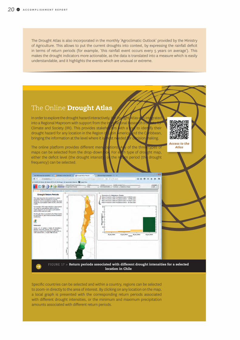
The Online Drought AtlasIn order to explore the drought hazard interactively, the Drought Atlas was integrated into a Regional Maproom with support from the International Research Institute for Climate and Society (IRI). This provides stakeholders with a tool to identify their drought hazard for any location in the Region of Latin America and the Caribbean, bringing the information at the level where it is most needed for decision making.
The online platform provides different menu options. Any of the three types of maps can be selected from the drop-down box. For each type of drought map, either the deficit level (the drought intensity) or the return period (the drought frequency) can be selected.
FIGURE 17 > Return periods associated with different drought intensities for a selected location in Chile
Specific countries can be selected and within a country, regions can be selected to zoom-in directly to the area of interest. By clicking on any location on the map, a local graph is presented with the corresponding return periods associated with different drought intensities, or the minimum and maximum precipitation amounts associated with different return periods.
Access to the Atlas
A C C O M P L I S H M E N T R E P O R T 21
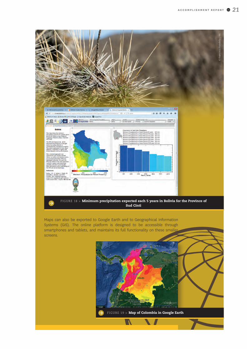
Maps can also be exported to Google Earth and to Geographical Information Systems (GIS). The online platform is designed to be accessible through smartphones and tablets, and maintains its full functionality on these smaller screens.
FIGURE 18 > Minimum precipitation expected each 5 years in Bolivia for the Province of Sud Cinti
FIGURE 19 > Map of Colombia in Google Earth
© F
ranc
isco
Fio
ndel
la /
IRI
A C C O M P L I S H M E N T R E P O R T22
Building capacities to face water resources challenges
International Symposium on Drought Management Tools
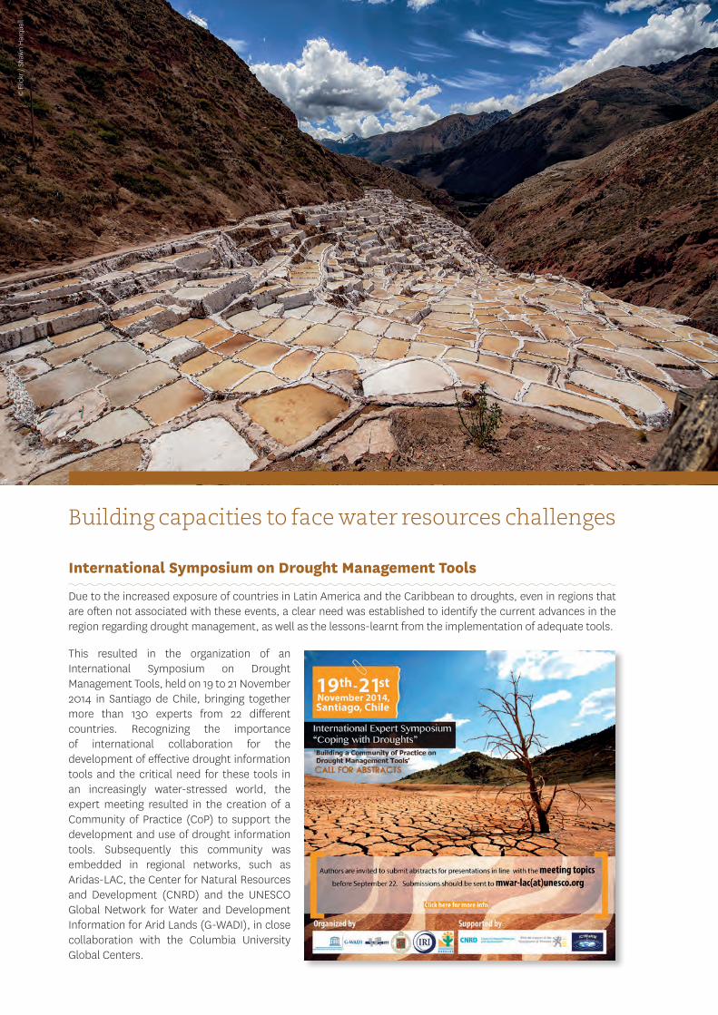
Due to the increased exposure of countries in Latin America and the Caribbean to droughts, even in regions that are often not associated with these events, a clear need was established to identify the current advances in the region regarding drought management, as well as the lessons-learnt from the implementation of adequate tools.
This resulted in the organization of an International Symposium on Drought Management Tools, held on 19 to 21 November 2014 in Santiago de Chile, bringing together more than 130 experts from 22 different countries. Recognizing the importance of international collaboration for the development of effective drought information tools and the critical need for these tools in an increasingly water-stressed world, the expert meeting resulted in the creation of a Community of Practice (CoP) to support the development and use of drought information tools. Subsequently this community was embedded in regional networks, such as Aridas-LAC, the Center for Natural Resources and Development (CNRD) and the UNESCO Global Network for Water and Development Information for Arid Lands (G-WADI), in close collaboration with the Columbia University Global Centers.
© F
lickr
/ S
haw
n H
arq
uail
A C C O M P L I S H M E N T R E P O R T 23
The Drought Information Community of Practice (CoP) encourages dialogue and collaboration as a means to inform and accelerate the development and use of effective drought information tools. The CoP allows all members of the group to share information and experiences with each other, providing members with an opportunity to exchange knowledge. It also creates an agenda to support students and researchers to identify new topics of research, connecting individuals from around the world and allowing them to work together on topics of similar interest.
Based on the discussions and outcomes of the International Symposium, a set of recommendations and key messages were extracted, and presented in the Santiago Declaration on Drought Management Tools. This declaration provides a roadmap to address current gaps and opportunities to improve Drought Management Tools in the region.
FIGURE 20 > Extract from the Santiago Declaration on Drought Management Tools
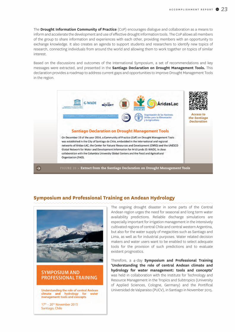
Symposium and Professional Training on Andean Hydrology
The ongoing drought disaster in some parts of the Central Andean region urges the need for seasonal and long term water availability predictions. Reliable discharge simulations are especially important for irrigation management in the intensively cultivated regions of central Chile and central western Argentina, but also for the water supply of megacities such as Santiago and Lima, as well as for industrial purposes. Water related decision makers and water users want to be enabled to select adequate tools for the provision of such predictions and to evaluate existent prognostics.
Therefore, a 4-day Symposium and Professional Training ‘Understanding the role of central Andean climate and hydrology for water management: tools and concepts’ was held in collaboration with the Institute for Technology and Resource Management in the Tropics and Subtropics (University of Applied Sciences, Cologne, Germany) and the Pontifical Universidad de Valparaiso (PUCV), in Santiago in November 2015.
Access to the Santiago Declaration
A C C O M P L I S H M E N T R E P O R T24
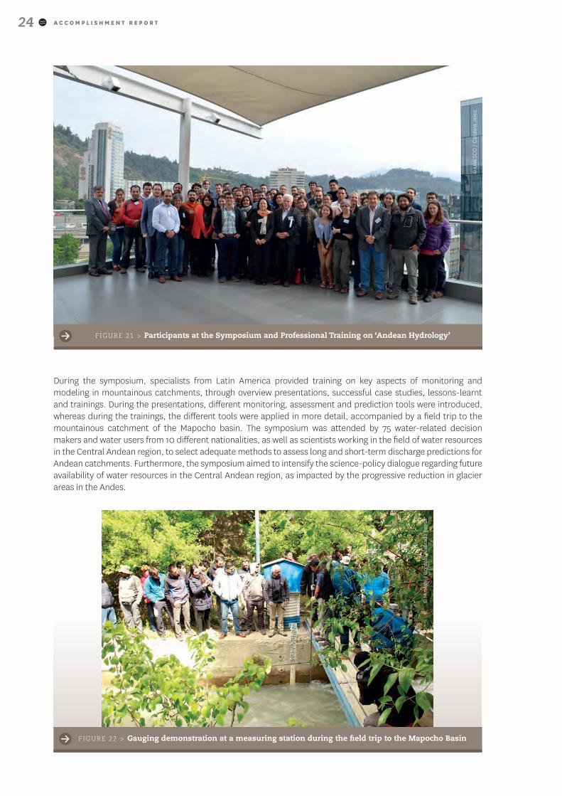
During the symposium, specialists from Latin America provided training on key aspects of monitoring and modeling in mountainous catchments, through overview presentations, successful case studies, lessons-learnt and trainings. During the presentations, different monitoring, assessment and prediction tools were introduced, whereas during the trainings, the different tools were applied in more detail, accompanied by a field trip to the mountainous catchment of the Mapocho basin. The symposium was attended by 75 water-related decision makers and water users from 10 different nationalities, as well as scientists working in the field of water resources in the Central Andean region, to select adequate methods to assess long and short-term discharge predictions for Andean catchments. Furthermore, the symposium aimed to intensify the science-policy dialogue regarding future availability of water resources in the Central Andean region, as impacted by the progressive reduction in glacier areas in the Andes.
FIGURE 21 > Participants at the Symposium and Professional Training on ‘Andean Hydrology’
FIGURE 22 > Gauging demonstration at a measuring station during the field trip to the Mapocho Basin
© U
NES
CO
/ C
arol
ina
Jere
z
© M
inA
gri /
Gon
zalo
Alv
arad
o Pe
nsa
A C C O M P L I S H M E N T R E P O R T 25
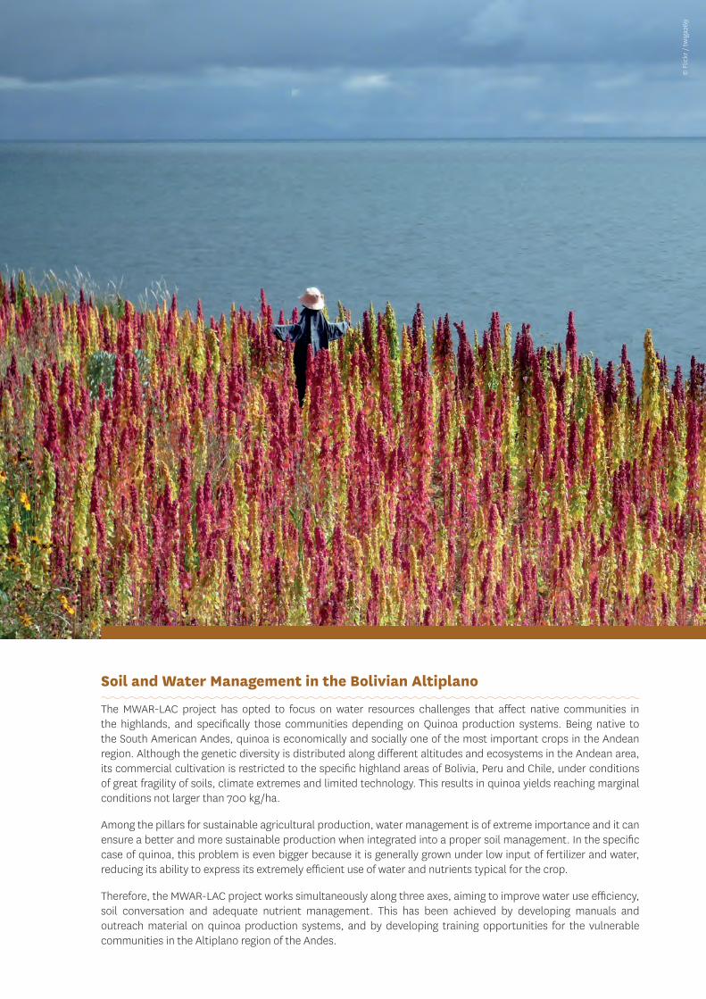
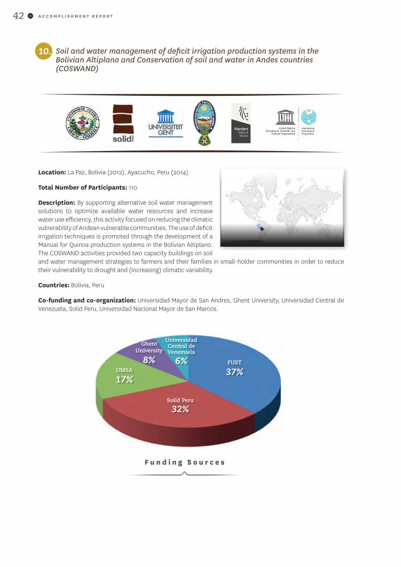
Soil and Water Management in the Bolivian Altiplano
The MWAR-LAC project has opted to focus on water resources challenges that affect native communities in the highlands, and specifically those communities depending on Quinoa production systems. Being native to the South American Andes, quinoa is economically and socially one of the most important crops in the Andean region. Although the genetic diversity is distributed along different altitudes and ecosystems in the Andean area, its commercial cultivation is restricted to the specific highland areas of Bolivia, Peru and Chile, under conditions of great fragility of soils, climate extremes and limited technology. This results in quinoa yields reaching marginal conditions not larger than 700 kg/ha.
Among the pillars for sustainable agricultural production, water management is of extreme importance and it can ensure a better and more sustainable production when integrated into a proper soil management. In the specific case of quinoa, this problem is even bigger because it is generally grown under low input of fertilizer and water, reducing its ability to express its extremely efficient use of water and nutrients typical for the crop.
Therefore, the MWAR-LAC project works simultaneously along three axes, aiming to improve water use efficiency, soil conversation and adequate nutrient management. This has been achieved by developing manuals and outreach material on quinoa production systems, and by developing training opportunities for the vulnerable communities in the Altiplano region of the Andes.
© F
lickr
/ t
wig
a269
A C C O M P L I S H M E N T R E P O R T26
>> Deficit Irrigation Production Systems in the Bolivian Altiplano
In order to support alternative soil water management solutions in vulnerable drylands, to optimize available water resources and increase water use efficiency, a pilot study treating deficit irrigation in vulnerable drylands of Bolivia was targeted. Deficit irrigation is an optimization strategy in which irrigation is applied during drought-sensitive growth stages of a crop, while water usage is reduced during drought-tolerant stages. By reducing the water usage, the technique aims to optimize the water use efficiency.
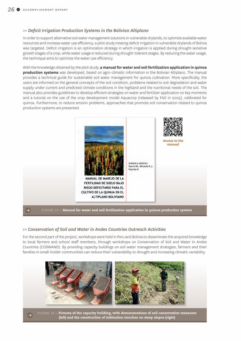
With the knowledge obtained by the pilot study, a manual for water and soil fertilization application in quinoa production systems was developed, based on agro-climatic information in the Bolivian Altiplano. The manual provides a technical guide for sustainable soil water management for quinoa cultivation. More specifically, the users are informed on the general concepts of the soil condition, problems related to soil degradation and water supply under current and predicted climate conditions in the highland and the nutritional needs of the soil. The manual also provides guidelines to develop efficient strategies on water and fertilizer application on key moments and a tutorial on the use of the crop development model Aquacrop (released by FAO in 2005), calibrated for quinoa. Furthermore, to reduce erosion problems, approaches that promote soil conservation related to quinoa production systems are presented.
FIGURE 23 > Manual for water and soil fertilization application in quinoa production system
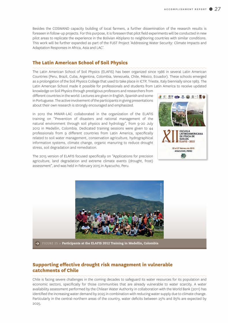
>> Conservation of Soil and Water in Andes Countries Outreach Activities
For the second part of the project, workshops were held in Peru and Bolivia to disseminate the acquired knowledge to local farmers and school staff members, through workshops on Conservation of Soil and Water in Andes Countries (COSWAND). By providing capacity buildings on soil water management strategies, farmers and their families in small-holder communities can reduce their vulnerability to drought and increasing climatic variability.
Access to the manual
FIGURE 24 > Pictures of the capacity building, with demonstrations of soil conservation measures (left) and the construction of infiltration trenches on steep slopes (right)
© D
eyan
ira
Lob
o
© D
eyan
ira
Lob
o
A C C O M P L I S H M E N T R E P O R T 27
Besides the COSWAND capacity building of local farmers, a further dissemination of the research results is foreseen in follow-up projects. For this purpose, it is foreseen that pilot field experiments will be conducted in new pilot areas to replicate the experience in the Bolivian Altiplano to neighboring countries with similar conditions. This work will be further expanded as part of the FUST Project ‘Addressing Water Security: Climate Impacts and Adaptation Responses in Africa, Asia and LAC’.
The Latin American School of Soil Physics
The Latin American School of Soil Physics (ELAFIS) has been organized since 1986 in several Latin American Countries (Peru, Brazil, Cuba, Argentina, Colombia, Venezuela, Chile, México, Ecuador). These schools emerged as a prolongation of the Soil Physics College that used to take place in ICTP, Trieste, Italy biennially since 1983. The Latin American School made it possible for professionals and students from Latin America to receive updated knowledge on Soil Physics through prestigious professors and researchers from different countries in the world. Lectures are given in English, Spanish and some in Portuguese. The active involvement of the participants in giving presentations about their own research is strongly encouraged and emphasized.
In 2012 the MWAR-LAC collaborated in the organization of the ELAFIS training on “Prevention of disasters and rational management of the natural environment through soil physics and hydrology”, from 9-20 July 2012 in Medellin, Colombia. Dedicated training sessions were given to 44 professionals from 9 different countries from Latin America, specifically related to soil water management, conservation agriculture, hydrographical information systems, climate change, organic manuring to reduce drought stress, soil degradation and remediation.
The 2015 version of ELAFIS focused specifically on “Applications for precision agriculture, land degradation and extreme climate events (drought, frost) assessment”, and was held in February 2015 in Ayacucho, Peru.
Supporting effective drought risk management in vulnerable catchments of Chile
Chile is facing severe challenges in the coming decades to safeguard its water resources for its population and economic sectors, specifically for those communities that are already vulnerable to water scarcity. A water availability assessment performed by the Chilean Water Authority in collaboration with the World Bank (2011) has identified the increasing water demand by 2025 in combination with reducing water supply due to climate change. Particularly in the central-northern areas of the country, water deficits between 25% and 85% are expected by 2025.
FIGURE 25 > Participants at the ELAFIS 2012 Training in Medellin, Colombia
© D
eyan
ira
Lob
o
A C C O M P L I S H M E N T R E P O R T28
Groundwater resources play a crucial role in the provision of water for human consumption, agricultural and industrial activities, but also to provide ecological services through wetlands and highland marshes. The current understanding of the water balance is insufficient, due to lack of adequate groundwater monitoring tools, endangering the sustainable usage of this (limited) renewable resource.
Due to the current and unexpected stress on water resources, it is crucial to identify the vulnerable communities to (ground)water scarcity as a first step to develop a pathway to increase the resilience of the population. Therefore, the MWAR-LAC project engaged with the Chilean Ministry of Agriculture and the British Council in the project ‘Supporting Effective Drought Risk Management in Vulnerable Catchments of Chile’, building capacities for groundwater drought monitoring and assessment of (groundwater) drought vulnerability, with the goal to strengthen drought management and policy.
By providing the necessary tools to identify conditions of groundwater stress more effectively, the activity strengthened the governmental agencies in charge of monitoring water scarcity.. This enabled the identification of those areas that suffer most from drought stress, that at the same time are identified as communities the most vulnerable to drought. By shaping the drought management policies to take both objective (ground)water indicators into account, as well as the most vulnerable areas, the training programme effectively addressed the unequal impact of drought on the poorer, more vulnerable communities and contributed to a reduction in poverty traps that are often associated to climatic hazards.
The training programme is threefold, with the first part focusing on groundwater monitoring and early warning capacities, that were previously inexistent. As longstanding expertise is available at UK institutes, a technology transfer took place through a workshop held in Chile in November 2015. During this 3-day workshop, more than 20 professionals were trained by two specialists in hydrology from the University of Birmingham on the application of the threshold level method to quantify duration and deficit volume of aquifers during drought events. Exercises were performed based on Spanish and Swedish case studies. To put these new capacities into practice, Chilean datasets have been consolidated as part of the Chilean Climate Data Library to build effective groundwater indicators for drought monitoring to become operational during 2016.
The second part of the training addressed drought vulnerabilities. A training was held in early 2016 with representatives from multiple agencies to assess drought impacts in order to develop an effective drought vulnerability assessment. The third and final part of the training aims at integrating the first two parts of the training in a process of policy making on drought management, which requires a dialogue with the different national actors involved. For this reason, a set of high-level national meetings are planned to complement the trainings and to involve the political sector into this dialogue.
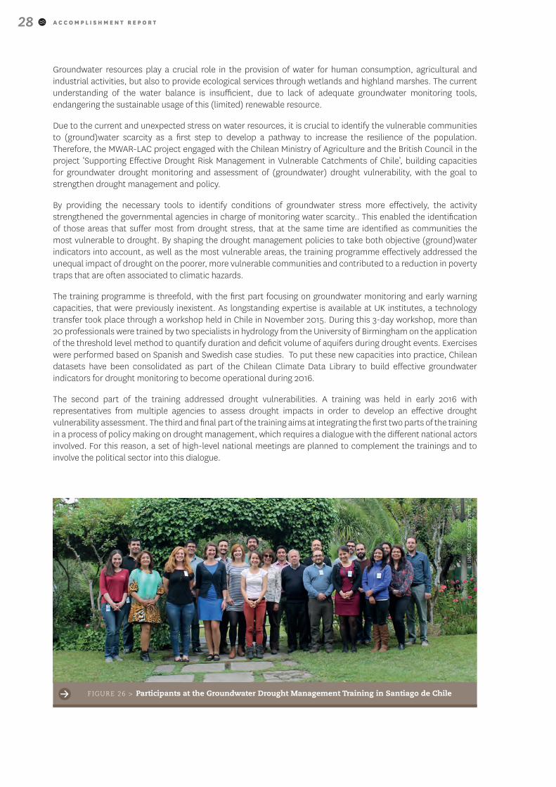
FIGURE 26 > Participants at the Groundwater Drought Management Training in Santiago de Chile
© U
NES
CO
/ C
arol
ina
Jere
z
A C C O M P L I S H M E N T R E P O R T 29
Access to the database
Outreach and Dissemination
The Dryland Expert Database
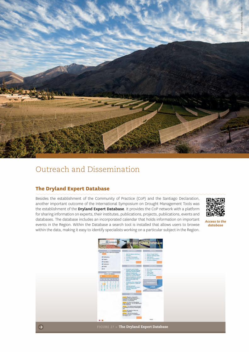
Besides the establishment of the Community of Practice (CoP) and the Santiago Declaration, another important outcome of the International Symposium on Drought Management Tools was the establishment of the Dryland Expert Database. It provides the CoP network with a platform for sharing information on experts, their institutes, publications, projects, publications, events and databases. The database includes an incorporated calendar that holds information on important events in the Region. Within the Database a search tool is installed that allows users to browse within the data, making it easy to identify specialists working on a particular subject in the Region.
FIGURE 27 > The Dryland Expert Database
© F
ranc
isco
Fio
ndel
la /
IRI
A C C O M P L I S H M E N T R E P O R T30
Access to the website
In the follow-up stage of this project further activities and meetings of the CoP are planned to address the gaps identified in the Santiago Declaration by the expert group and to streamline the dialogue between the scientific, political, public and private sector regarding the state of the art to assess and manage droughts in drylands of Latin America.
The MWAR-LAC Project Website
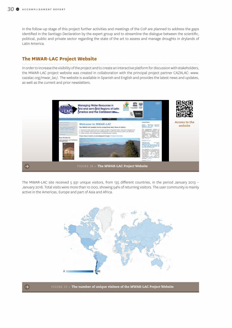
In order to increase the visibility of the project and to create an interactive platform for discussion with stakeholders, the MWAR-LAC project website was created in collaboration with the principal project partner CAZALAC: www.cazalac.org/mwar_lac/. The website is available in Spanish and English and provides the latest news and updates, as well as the current and prior newsletters.
FIGURE 28 > The MWAR-LAC Project Website
The MWAR-LAC site received 5 931 unique visitors, from 135 different countries, in the period January 2013 – January 2016. Total visits were more than 10 000, showing 54% of returning visitors. The user community is mainly active in the Americas, Europe and part of Asia and Africa.
FIGURE 29 > The number of unique visitors of the MWAR-LAC Project Website

A C C O M P L I S H M E N T R E P O R T 31
Access to the brochure
The MWAR-LAC Newsletter
A set of newsletters have been launched since September 2013 to keep partners and interested parties actively updated about the advances, past and upcoming activities, new tools and outreach material of the MWAR-LAC project activities. Until now already four newsletters have been realized, reaching more than 6 000 regional and world-wide correspondents. Digital versions are also accessible at the MWAR-LAC website, both in English and Spanish.
MWAR-LAC Brochures
In 2015 brochures of several project activities were published to present the project’s developed products and outcomes, in order to reach a broader public. Digital versions are available for download at the MWAR-LAC website, both in English and Spanish, and were widely disseminated through the newsletters.
The already published brochures concern the overall MWAR-LAC project, the Drought Observatories for LAC, the Drought Atlas, the G-WADI project (Global Network on Water and Development Information for Arid Lands) and information on ‘The Impact of Glacier Retreat in the Andes’ initiative. The dissemination of the brochures has led to an increased awareness about the MWAR-LAC project, as well as an increased use of the website and the tools developed during the project.
FIGURE 30 > Extract from the November 2015 MWAR-LAC newsletter
A C C O M P L I S H M E N T R E P O R T32
The MWAR-LAC Project in Numbers
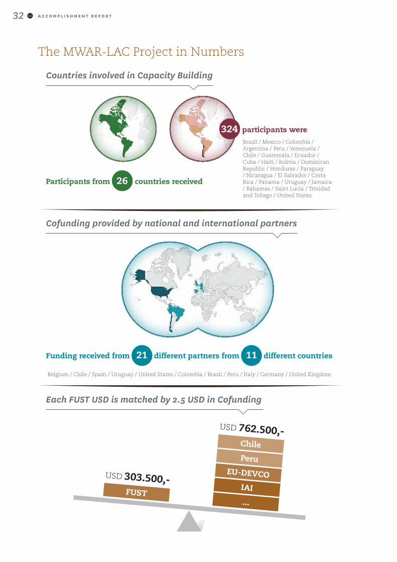
Countries involved in Capacity Building
Participants from 26 countries received
324 participants were Brazil / Mexico / Colombia / Argentina / Peru / Venezuela / Chile / Guatemala / Ecuador / Cuba / Haiti / Bolivia / Dominican Republic / Honduras / Paraguay / Nicaragua / El Salvador / Costa Rica / Panama / Uruguay / Jamaica / Bahamas / Saint Lucia / Trinidad and Tobago / United States
Cofunding provided by national and international partners
Funding received from 21 different partners from 11 different countries
Belgium / Chile / Spain / Uruguay / United States / Colombia / Brazil / Peru / Italy / Germany / United Kingdom
Each FUST USD is matched by 2.5 USD in Cofunding
FUST
USD 303.500,-EU-DEVCO
Chile
Peru
IAI
USD 762.500,-
...
A C C O M P L I S H M E N T R E P O R T 33
Detailed Overview of Activities and Partners
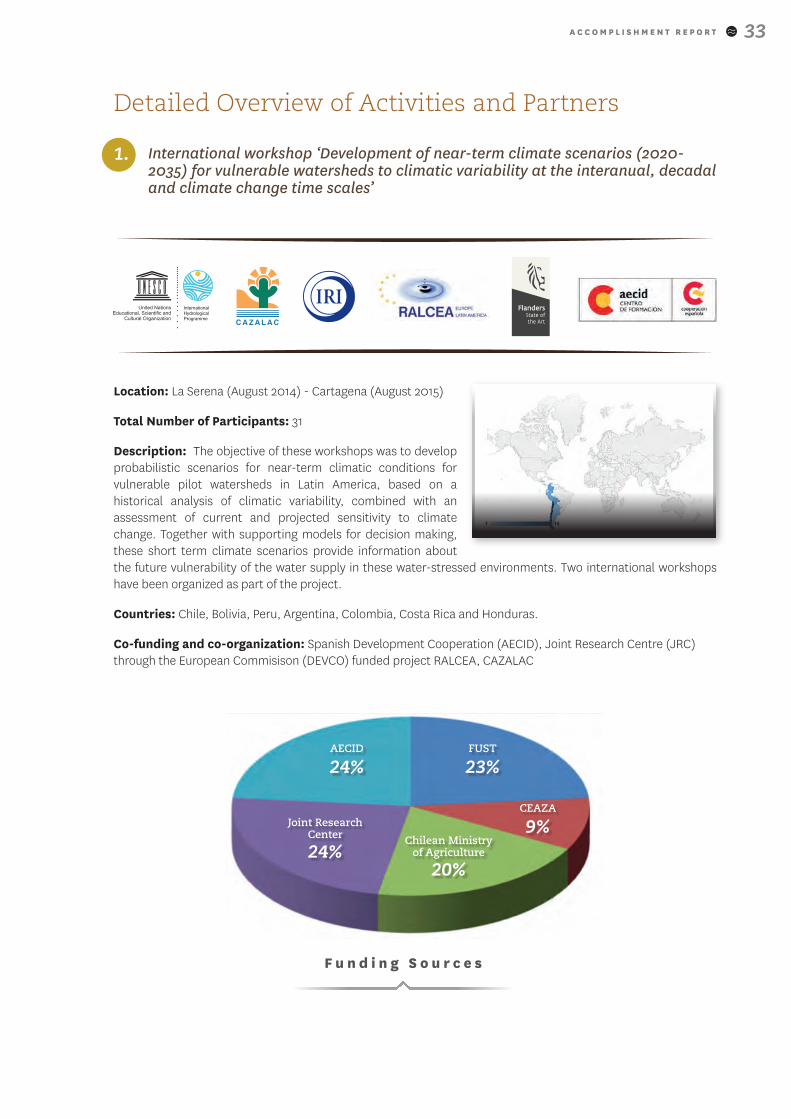
1. International workshop ‘Development of near-term climate scenarios (2020-2035) for vulnerable watersheds to climatic variability at the interanual, decadal and climate change time scales’
Location: La Serena (August 2014) - Cartagena (August 2015)
Total Number of Participants: 31
Description: The objective of these workshops was to develop probabilistic scenarios for near-term climatic conditions for vulnerable pilot watersheds in Latin America, based on a historical analysis of climatic variability, combined with an assessment of current and projected sensitivity to climate change. Together with supporting models for decision making, these short term climate scenarios provide information about the future vulnerability of the water supply in these water-stressed environments. Two international workshops have been organized as part of the project.
Countries: Chile, Bolivia, Peru, Argentina, Colombia, Costa Rica and Honduras.
Co-funding and co-organization: Spanish Development Cooperation (AECID), Joint Research Centre (JRC) through the European Commisison (DEVCO) funded project RALCEA, CAZALAC
Chilean Ministry of Agriculture
20%
Joint Research Center
24%
AECID
24%FUST
23%
CEAZA
9%
F u n d i n g S o u r c e s
A C C O M P L I S H M E N T R E P O R T34
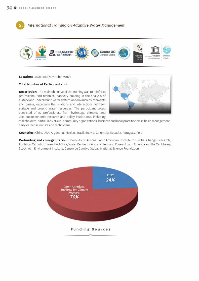
2. International Training on Adaptive Water Management
Location: La Serena (November 2012)
Total Number of Participants: 42
Description: The main objective of the training was to reinforce professional and technical capacity building in the analysis of surface and underground water systems in semiarid environments and basins, especially the relations and interactions between surface and ground water resources. The participant group consisted of 22 professionals from hydrology, climate, land use, socioeconomic research and policy institutions, including stakeholders, particularly NGOs, community organizations, business and local practitioners in basin management, early career scientists and technicians.
Countries: Chile, USA, Argentina, Mexico, Brazil, Bolivia, Colombia, Ecuador, Paraguay, Peru
Co-funding and co-organization: University of Arizona, Inter-American Institute for Global Change Research, Pontifical Catholic University of Chile, Water Center for Arid and Semiarid Zones of Latin America and the Caribbean, Stockholm Environment Institute, Centro de Cambio Global, National Science Foundation.
Inter-American Institute for Climate
Research
76%
FUST
24%
F u n d i n g S o u r c e s
A C C O M P L I S H M E N T R E P O R T 35
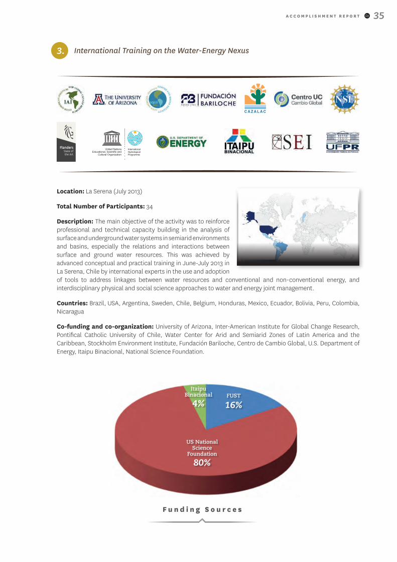
3. International Training on the Water-Energy Nexus
Location: La Serena (July 2013)
Total Number of Participants: 34
Description: The main objective of the activity was to reinforce professional and technical capacity building in the analysis of surface and underground water systems in semiarid environments and basins, especially the relations and interactions between surface and ground water resources. This was achieved by advanced conceptual and practical training in June-July 2013 in La Serena, Chile by international experts in the use and adoption of tools to address linkages between water resources and conventional and non-conventional energy, and interdisciplinary physical and social science approaches to water and energy joint management.
Countries: Brazil, USA, Argentina, Sweden, Chile, Belgium, Honduras, Mexico, Ecuador, Bolivia, Peru, Colombia, Nicaragua
Co-funding and co-organization: University of Arizona, Inter-American Institute for Global Change Research, Pontifical Catholic University of Chile, Water Center for Arid and Semiarid Zones of Latin America and the Caribbean, Stockholm Environment Institute, Fundación Bariloche, Centro de Cambio Global, U.S. Department of Energy, Itaipu Binacional, National Science Foundation.
US National Science
Foundation
80%
FUST
16%
F u n d i n g S o u r c e s
Itaipu Binacional
4%
A C C O M P L I S H M E N T R E P O R T36
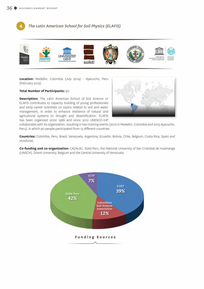
4. The Latin American School for Soil Physics (ELAFIS)
Location: Medellin, Colombia (July 2014) - Ayacucho, Peru (February 2015)
Total Number of Participants: 90
Description: The Latin American School of Soil Science or ELAFIS contributes to capacity building of young professionals and early-career scientists on topics related to soil and water management, in order to enhance resilience of natural and agricultural systems to drought and desertification. ELAFIS has been organized since 1986 and since 2012 UNESCO-IHP collaborates with its organization, resulting in two training events (2012 in Medellin, Colombia and 2015 Ayacucho, Peru), in which 90 people participated from 13 different countries.
Countries: Colombia, Peru, Brasil, Venezuela, Argentina, Ecuador, Bolivia, Chile, Belgium, Costa Rica, Spain and Honduras.
Co-funding and co-organization: CAZALAC, Solid Peru, the National University of San Cristóbal de Huamanga (UNSCH), Ghent University, Belgium and the Central University of Venezuela
Colombian Soil Science Association
12%
Solid Peru
42%
ICTP
7%FUST
39%
F u n d i n g S o u r c e s
A C C O M P L I S H M E N T R E P O R T 37
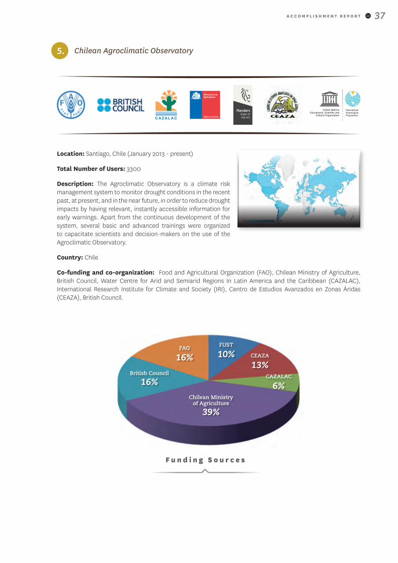
5. Chilean Agroclimatic Observatory
Location: Santiago, Chile (January 2013 - present)
Total Number of Users: 3300
Description: The Agroclimatic Observatory is a climate risk management system to monitor drought conditions in the recent past, at present, and in the near future, in order to reduce drought impacts by having relevant, instantly accessible information for early warnings. Apart from the continuous development of the system, several basic and advanced trainings were organized to capacitate scientists and decision-makers on the use of the Agroclimatic Observatory.
Country: Chile
Co-funding and co-organization: Food and Agricultural Organization (FAO), Chilean Ministry of Agriculture, British Council, Water Centre for Arid and Semiarid Regions In Latin America and the Caribbean (CAZALAC), International Research Institute for Climate and Society (IRI), Centro de Estudios Avanzados en Zonas Áridas (CEAZA), British Council.
F u n d i n g S o u r c e s
Chilean Ministry of Agriculture
39%
British Council
16%
FAO
16%
FUST
10%
CAZALAC
6%
CEAZA
13%
A C C O M P L I S H M E N T R E P O R T38
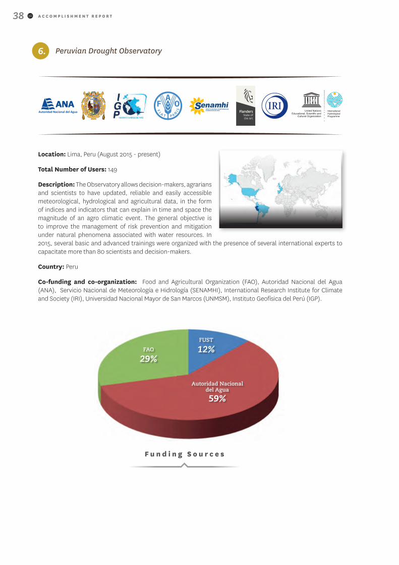
6. Peruvian Drought Observatory
Location: Lima, Peru (August 2015 - present)
Total Number of Users: 149
Description: The Observatory allows decision-makers, agrarians and scientists to have updated, reliable and easily accessible meteorological, hydrological and agricultural data, in the form of indices and indicators that can explain in time and space the magnitude of an agro climatic event. The general objective is to improve the management of risk prevention and mitigation under natural phenomena associated with water resources. In 2015, several basic and advanced trainings were organized with the presence of several international experts to capacitate more than 80 scientists and decision-makers.
Country: Peru
Co-funding and co-organization: Food and Agricultural Organization (FAO), Autoridad Nacional del Agua (ANA), Servicio Nacional de Meteorología e Hidrología (SENAMHI), International Research Institute for Climate and Society (IRI), Universidad Nacional Mayor de San Marcos (UNMSM), Instituto Geofísica del Perú (IGP).
Autoridad Nacional del Agua
59%
FAO
29%
FUST
12%
F u n d i n g S o u r c e s
A C C O M P L I S H M E N T R E P O R T 39
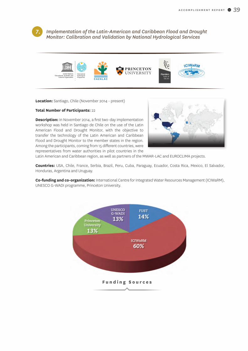
7. Implementation of the Latin-American and Caribbean Flood and Drought Monitor: Calibration and Validation by National Hydrological Services
Location: Santiago, Chile (November 2014 - present)
Total Number of Participants: 22
Description: In November 2014, a first two-day implementation workshop was held in Santiago de Chile on the use of the Latin American Flood and Drought Monitor, with the objective to transfer the technology of the Latin American and Caribbean Flood and Drought Monitor to the member states in the region. Among the participants, coming from 15 different countries, were representatives from water authorities in pilot countries in the Latin American and Caribbean region, as well as partners of the MWAR-LAC and EUROCLIMA projects.
Countries: USA, Chile, France, Serbia, Brazil, Peru, Cuba, Paraguay, Ecuador, Costa Rica, Mexico, El Salvador, Honduras, Argentina and Uruguay.
Co-funding and co-organization: International Centre for Integrated Water Resources Management (ICIWaRM), UNESCO G-WADI programme, Princeton University.
UNESCO G-WADI
13%
ICIWaRM
60%
Princeton University
13%
FUST
14%
F u n d i n g S o u r c e s
A C C O M P L I S H M E N T R E P O R T40
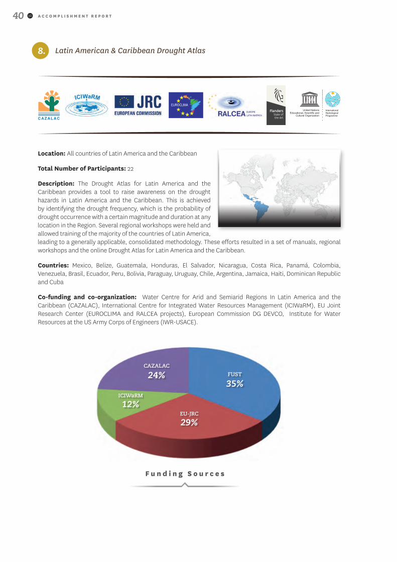
8. Latin American & Caribbean Drought Atlas
Location: All countries of Latin America and the Caribbean
Total Number of Participants: 22
Description: The Drought Atlas for Latin America and the Caribbean provides a tool to raise awareness on the drought hazards in Latin America and the Caribbean. This is achieved by identifying the drought frequency, which is the probability of drought occurrence with a certain magnitude and duration at any location in the Region. Several regional workshops were held and allowed training of the majority of the countries of Latin America, leading to a generally applicable, consolidated methodology. These efforts resulted in a set of manuals, regional workshops and the online Drought Atlas for Latin America and the Caribbean.
Countries: Mexico, Belize, Guatemala, Honduras, El Salvador, Nicaragua, Costa Rica, Panamá, Colombia, Venezuela, Brasil, Ecuador, Peru, Bolivia, Paraguay, Uruguay, Chile, Argentina, Jamaica, Haiti, Dominican Republic and Cuba
Co-funding and co-organization: Water Centre for Arid and Semiarid Regions In Latin America and the Caribbean (CAZALAC), International Centre for Integrated Water Resources Management (ICIWaRM), EU Joint Research Center (EUROCLIMA and RALCEA projects), European Commission DG DEVCO, Institute for Water Resources at the US Army Corps of Engineers (IWR-USACE).
EU-JRC
29%
ICIWaRM
12%
CAZALAC
24% FUST
35%
F u n d i n g S o u r c e s
A C C O M P L I S H M E N T R E P O R T 41
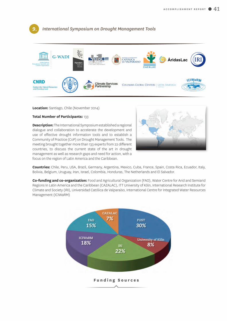
9. International Symposium on Drought Management Tools
Location: Santiago, Chile (November 2014)
Total Number of Participants: 133
Description: The International Symposium established a regional dialogue and collaboration to accelerate the development and use of effective drought information tools and to establish a Community of Practice (CoP) on Drought Management Tools. The meeting brought together more than 133 experts from 22 different countries, to discuss the current state of the art in drought management as well as research gaps and need for action, with a focus on the region of Latin America and the Caribbean.
Countries: Chile, Peru, USA, Brazil, Germany, Argentina, Mexico, Cuba, France, Spain, Costa Rica, Ecuador, Italy, Bolivia, Belgium, Uruguay, Iran, Israel, Colombia, Honduras, The Netherlands and El Salvador.
Co-funding and co-organization: Food and Agricultural Organization (FAO), Water Centre for Arid and Semiarid Regions In Latin America and the Caribbean (CAZALAC), ITT University of Köln, International Research Institute for Climate and Society (IRI), Universidad Católica de Valparaíso, International Centre for Integrated Water Resources Management (ICIWaRM)
ICIWaRM
18%
CAZALAC
7% FUST
30%FAO
15%
F u n d i n g S o u r c e s
University of Koln
8%
..
IRI
22%
A C C O M P L I S H M E N T R E P O R T42
10. Soil and water management of deficit irrigation production systems in the Bolivian Altiplano and Conservation of soil and water in Andes countries (COSWAND)
Location: La Paz, Bolivia (2012), Ayacucho, Peru (2014)
Total Number of Participants: 110
Description: By supporting alternative soil water management solutions to optimize available water resources and increase water use efficiency, this activity focused on reducing the climatic vulnerability of Andean vulnerable communities. The use of deficit irrigation techniques is promoted through the development of a Manual for Quinoa production systems in the Bolivian Altiplano. The COSWAND activities provided two capacity buildings on soil and water management strategies to farmers and their families in small-holder communities in order to reduce their vulnerability to drought and (increasing) climatic variability.
Countries: Bolivia, Peru
Co-funding and co-organization: Universidad Mayor de San Andres, Ghent University, Universidad Central de Venezuela, Solid Peru, Universidad Nacional Mayor de San Marcos.
Universidad Central de Venezuela
6%
Solid Peru
32%
Ghent University
8% FUST
37%UMSA
17%
F u n d i n g S o u r c e s
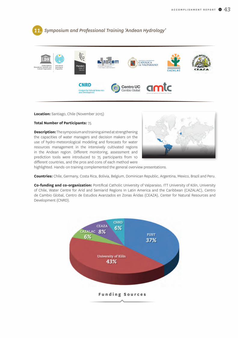
A C C O M P L I S H M E N T R E P O R T 43
11. Symposium and Professional Training ‘Andean Hydrology’
Location: Santiago, Chile (November 2015)
Total Number of Participants: 75
Description: The symposium and training aimed at strengthening the capacities of water managers and decision makers on the use of hydro-meteorological modeling and forecasts for water resources management in the intensively cultivated regions in the Andean region. Different monitoring, assessment and prediction tools were introduced to 75 participants from 10 different countries, and the pros and cons of each method were highlighted. Hands-on training complemented the general overview presentations.
Countries: Chile, Germany, Costa Rica, Bolivia, Belgium, Dominican Republic, Argentina, Mexico, Brazil and Peru.
Co-funding and co-organization: Pontifical Catholic University of Valparaiso, ITT University of Köln, University of Chile, Water Centre for Arid and Semiarid Regions In Latin America and the Caribbean (CAZALAC), Centro de Cambio Global, Centro de Estudios Avanzados en Zonas Áridas (CEAZA), Center for Natural Resources and Development (CNRD).
CAZALAC
6%
CEAZA
8%FUST
37%
CNRD
6%
F u n d i n g S o u r c e s
University of Koln
43%
..
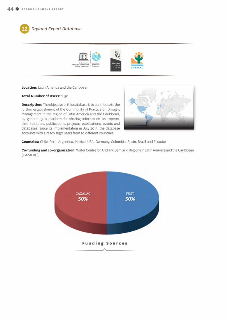
A C C O M P L I S H M E N T R E P O R T44
12. Dryland Expert Database
Location: Latin America and the Caribbean
Total Number of Users: 1850
Description: The objective of this database is to contribute to the further establishment of the Community of Practice on Drought Management in the region of Latin America and the Caribbean, by generating a platform for sharing information on experts, their institutes, publications, projects, publications, events and databases. Since its implementation in July 2013, the database accounts with already 1850 users from 10 different countries.
Countries: Chile, Peru, Argentina, Mexico, USA, Germany, Colombia, Spain, Brazil and Ecuador
Co-funding and co-organization: Water Centre for Arid and Semiarid Regions in Latin America and the Caribbean (CAZALAC)
CAZALAC
50%FUST
50%
F u n d i n g S o u r c e s
A C C O M P L I S H M E N T R E P O R T 45
References
Greene, A.M., M. Hellmuth, and J.W. Hansen. 2012a. A framework for the simulation of regional decadal variability for agricultural and other applications. CCAFS Report. International Research Institute for Climate and Society.
Ray, Patrick Alexander; Brown, Casey M. 2015. Confronting climate uncertainty in water resources planning and project design: the decision tree framework. Washington, D.C. .World Bank Group. http://documents.worldbank.org/curated/en/2015/08/24957941/confronting-climate-uncertainty-water-resources-planning-project-design-decision-tree-framework
EM-DAT, 2015. The International Disasters Database. www.emdat.be/

A C C O M P L I S H M E N T R E P O R T46

A C C O M P L I S H M E N T R E P O R T 47
A C C O M P L I S H M E N T R E P O R T48
CONTACT INFORMATION:
INTERNATIONAL HYDROLOGICAL PROGRAMME (IHP)
UNESCO / DIVISION OF WATER SCIENCES7, PLACE DE FONTENOY
F-75352 PARIS 07 SPTEL : (+33) 1 45 68 40 01
[email protected] – www.unesco.org/water/ihp
MWAR-LAC PROJECT WEBSITE:
http://www.cazalac.org/mwar_lac/


![W]MWaR - Interprétation, Traduction, Tourisme d'affaires · XcM_Rb_^da aXdbbWa b^] bX\W]MWaR 7WPVR?X\^ >h^aUM]WbMcW^] \ZhM]cWPW_McW^] RcZM aWUdRda b^]cZRbSMPcRdabPZXb_^dad]R^aUM]WbMcW^]](https://img.dokumen.tips/doc/110x75/5b95dfe009d3f29b178cce6f/wmwar-interpretation-traduction-tourisme-d-xcmrbda-axdbbwa-b-bxwmwar.jpg)