Embed Size (px)
Citation preview

1 Approved for public release, 17-114
Will Mortenson, NGA Foundation GEOINT Group
7 December 2016
NSG Open Mapping Enclave (NOME)
2 Approved for public release, 17-114
NSG Open Mapping Enclave (NOME)
An NGA initiative to implement Volunteer Geographic Information (VGI)
concepts and tools to produce foundation GEOINT data
within the Intelligence Community, the NSG, and among our foreign partners.

3 Approved for public release, 17-114
Volunteer Geographic Information (VGI): Crowd-sourced mapping
“Every Soldier a Sensor”
Wikimedia Commons, CC BY-SA 2.0 www.army.mil

4 Approved for public release, 17-114
Volunteered Geographic Information “Triad”
NOME
ActiveVGI
PassiveVGI
• Traditional VGI contributions from the “community-crowd” (not publicly accessible)
• Requirements based campaigns• Ad-hoc/crisis campaigns• Data conflation• Current capability
• Automated Feature Extraction (AFE) validation
• New feature generation• Quality assurance• Developing capability
• Imagery to the public via open crowd mapping website
• Crowd-seeding• Developing capability
CommunitySourcing
5 Approved for public release, 17-114
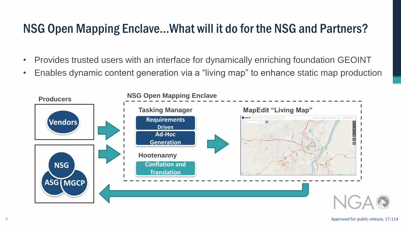
NSG Open Mapping Enclave…What will it do for the NSG and Partners?
RequirementsDriven
Ad-Hoc Generation
Tasking Manager
ASG MGCP
NSG
Vendors
Producers
MapEdit “Living Map”
• Provides trusted users with an interface for dynamically enriching foundation GEOINT
• Enables dynamic content generation via a “living map” to enhance static map production
NSG Open Mapping Enclave
Hootenanny
Conflation and Translation

6 Approved for public release, 17-114
Services
• “Living Map” with editing tools and data export including multiple data schemas
• Tasking Manager
• Geonode data repository
• Hootenanny data conflation tool
• Data investigation tools
• Extraction guides
• Question and answer message board
Security
• Virtual Private Cloud (VPC) provided through commercial cloud service
• NSG, ASG, MGCP access (NOT PUBLIC)
• Dual-factor authentication
NSG Open Mapping Enclave (NOME)

7 Approved for public release, 17-114
NOME Way Ahead
Program
• Outreach, outreach, outreach
• Training programs including videos and site visits
Technology Development
• SIPR deployment
• Investigating integration with Cartographic Web Services (CWS)
• Ground photo overlay
• Disconnected editing for mobile devices
• Integration with GIS desktop applications
• Network analysis via Open Source Routing Machine (OSRM)
• Synchronization across security domains