Embed Size (px)
Citation preview

Copyright © 2019 by the Committee for Human Rights in North KoreaCOPYRIGHT ©ALLSOURCE ANALYSIS, INC. 2016 3
H RN K
C H ’ O M A - B O N G R E S T R I C T E D A R E AH RN K
C A M P N O . 2 5
analysis also supports escapee and other reports indicating that Camp No. 25’s primary economic activity is focused on light industry and agriculture. Despite extensive satellite imagery coverage of the camp, AllSource is presently unable to confirm or deny escapee and open-source reports that the camp has a prisoner population of 5,000 people.
As with the analytical caution presented in previous reports (such as North Korea: Imagery Analysis Camp 16 and North Korea: Imagery Analysis of Camp 14 produced by HRNK and AllSource Analysis), it is important to reiterate that North Korean officials, especially those within the Korean People’s Army and the internal security organizations, clearly understand the importance of implementing camouflage, concealment, and deception (CCD) procedures to mask their operations and intentions.3 It would be reasonable to assume that they have done so here.
Location and Organization
Camp No. 25 is under the control of the
3 Bermudez Jr., Joseph S., Dinville, Andy and Eley, Mike. Imagery Analysis of Camp 16, (Washington, D.C.: The Committee for Human Rights in North Korea [HRNK], 2015) available at https://www.hrnk.org/uploads/pdfs/ASA_HRNK_Camp16_v8_full-res_FINAL_12_15_15.pdf and Bermudez Jr., Joseph S. Imagery Analysis: North Korea’s Camp No. 15, Update, (Washington, D.C.: HRNK, 2014) available at http://hrnk.org/uploads/pdfs/Camp%2025%20Update%20Good.pdf.
Prisons Bureau of the State Security Department (SSD), which is under the de facto control of the KWP OGD. Specifically, it is under the control of the SSD's North Hamgyong Provincial Bureau and is located approximately 7.5 km northwestof the port of Ch’ŏng-jin-si in Susŏng-dong, Ch’ŏngjin-si, Hamgyŏng-bukto.4 More specifically, it is
4 It is interesting to note that although the escapee descriptions of this facility’s mission matches that of other kwan-li-so, the physical characteristics ob-served in satellite imagery are more representative of the nation’s kyo-hwa-so, or long-term, felony penitentiaries and prison camps. David Hawk, The Hidden Gulag: Second Edition, Washington, D.C.: Committee for Human Rights in North Korea, 2012, www.hrnk.org/uploads/pdfs/HRNK_HiddenGu-lag2_Web_5-18.pdf. Another sources describes Camp No. 25 this way,
It is not structured as a village but is a fenced facility that looks like an ordinary prison camp [kyo-hwa-so] and is designed for collective living arrangements. The No. 25 [kwan-li-so] houses political prisoners only, while those who committed economic crimes are not allowed into the facility. Some inmates are released upon completion of their term as terms are fixed. Political criminals are detained alone with-out their families. …North Korean defector XXX [sic] testified, “Military personnel are sent off to the Susong kyo-hwa-so [No. 25 kwan-li-so] if their alleged crimes are of a political nature. The Susong kyo-hwa-so [No. 25 kwan-li-so] is for those serving terms of 10 years or longer, but they can return to society once they complete these terms.” It was also testified that the No. 25 kwan-li-so housed senior staff at the Provincial Party, the head of a local MPS office, and other high-ranking officials. North Korean defector XXX [sic] testified that the father of his
located on the south bank of the Sol-gol-ch’ŏn (i.e., Solgol stream) across from the village of Susŏng-dong, to which one foot and two road bridges connect it.
The date of establishment of Camp No. 25 is unclear. One report indicates that the camp was used as a prisoner-of-war camp housing South Korean soldiers at the end of the Korean War.5 This, how-ever, remains to be verified as it may not be referring to the present day camp but rather to an activity in this area. The area in which it is located has been involved in agricultural activities since at least the 1950s. Satellite imagery does indicate that Camp No. 25 was established prior to May 28, 1970, at which time it occupied an irregular shaped area that measured approximately 577 meters by 315 meters (631 yards by 344 yards) and encompassed 13.76 hectares (164,568
friend used to perform the duty of turning over Korean War POWs to South Korea, but he was arrested while attempting to cross the border at the river in Namyang, Onsung County, North Hamgyoung Province. He ended up at the No. 25 kwan-li-so in Chongjin.
Do Kyung-Ok et al., White Paper on Human Rights in North Korea 2015 (Seoul: Korea Institute for National Unification, 2015), p. 122, available at http://www.kinu.or.kr/eng/pub/pub_04_01.jsp.
5 “After the Korean War, it was used as a detention facility for South Korean POWs (Prisoners of War).” Do Kyung-Ok et al., White Paper on Human Rights in North Korea 2015 (Seoul: Korea Institute for National Unification, 2015), p. 122, available at http://www.kinu.or.kr/eng/pub/pub_04_01.jsp.
square yards) and was expanded slightly by January 27, 1976, when it measured approximately 700 meters by 315 meters (765 yards by 344 yards) and encom-passed 15.30 hectares (181,987 square yards) (Figure 1, Figure 2).6
High-resolution satellite imagery from January 18, 2003, through September 21, 2015, indicates that the camp has expanded during this period and that its primary economic activities are centered on agriculture and light industry (Figure 3 through Figure 15).
Several small villages and military facilities are located in the general area around the camp. The camp is connected to the regional electric power grid via overhead high voltage power transmis-sion cables that run from the camp to the substation approximately 1 kilometer to the southeast. It is connected to the national rail network via the station at Susŏng-dong, 800 meters to the east of the facility (Figure 16). The closest air facility to Camp No. 25 is the Korean People’s Air Force’s Sŭngam-ni Air Base, located 18 kilometers south-southwest. This is a training base, and based on its mission, organization, and location, almost certainly provides no support to Camp No. 25.
6 HRNK anticipates that we will be able to further refine the date of the camps establishment in future updates. Referenced imagery includes: KH-4B imagery dated May 28, 1970 and KH-9 (mapping camera) imagery dated January 27, 1976.
North Korea: Imagery Analysis of Camp No. 25 - Update 2
H RN KJUNE 20, 2019
Update 2North Korea’s Long-term Re-education through Labor Camp (Kyo-hwa-so) No. 4 at Kangdong
H RN K
THE COMMITTEE FOR HUMAN RIGHTS IN NORTH KOREA
원회
H RN K
Joseph S. Bermudez, Jr., Greg Scarlatoiu, Amanda Mortwedt Oh, and Rosa Park
Copyright © 2019 by the Committee for Human Rights in North Korea Copyright © 2019 by DigitalGlobe, NextView License
HRNK wishes to thank Ishimaru Jiro (Asia Press) for generously sharing ground imagery of Kyo-hwa-so No. 4, Bobby Holt for his peer review of this report and comments, and Allen Anderson for his gracious support of HRNK’s efforts to document North Korea’s vast system of unlawful imprisonment.

COPYRIGHT ©ALLSOURCE ANALYSIS, INC. 2016 3
H RN K
C H ’ O M A - B O N G R E S T R I C T E D A R E AH RN K
C A M P N O . 2 5
analysis also supports escapee and other reports indicating that Camp No. 25’s primary economic activity is focused on light industry and agriculture. Despite extensive satellite imagery coverage of the camp, AllSource is presently unable to confirm or deny escapee and open-source reports that the camp has a prisoner population of 5,000 people.
As with the analytical caution presented in previous reports (such as North Korea: Imagery Analysis Camp 16 and North Korea: Imagery Analysis of Camp 14 produced by HRNK and AllSource Analysis), it is important to reiterate that North Korean officials, especially those within the Korean People’s Army and the internal security organizations, clearly understand the importance of implementing camouflage, concealment, and deception (CCD) procedures to mask their operations and intentions.3 It would be reasonable to assume that they have done so here.
Location and Organization
Camp No. 25 is under the control of the
3 Bermudez Jr., Joseph S., Dinville, Andy and Eley, Mike. Imagery Analysis of Camp 16, (Washington, D.C.: The Committee for Human Rights in North Korea [HRNK], 2015) available at https://www.hrnk.org/uploads/pdfs/ASA_HRNK_Camp16_v8_full-res_FINAL_12_15_15.pdf and Bermudez Jr., Joseph S. Imagery Analysis: North Korea’s Camp No. 15, Update, (Washington, D.C.: HRNK, 2014) available at http://hrnk.org/uploads/pdfs/Camp%2025%20Update%20Good.pdf.
Prisons Bureau of the State Security Department (SSD), which is under the de facto control of the KWP OGD. Specifically, it is under the control of the SSD's North Hamgyong Provincial Bureau and is located approximately 7.5 km northwestof the port of Ch’ŏng-jin-si in Susŏng-dong, Ch’ŏngjin-si, Hamgyŏng-bukto.4 More specifically, it is
4 It is interesting to note that although the escapee descriptions of this facility’s mission matches that of other kwan-li-so, the physical characteristics ob-served in satellite imagery are more representative of the nation’s kyo-hwa-so, or long-term, felony penitentiaries and prison camps. David Hawk, The Hidden Gulag: Second Edition, Washington, D.C.: Committee for Human Rights in North Korea, 2012, www.hrnk.org/uploads/pdfs/HRNK_HiddenGu-lag2_Web_5-18.pdf. Another sources describes Camp No. 25 this way,
It is not structured as a village but is a fenced facility that looks like an ordinary prison camp [kyo-hwa-so] and is designed for collective living arrangements. The No. 25 [kwan-li-so] houses political prisoners only, while those who committed economic crimes are not allowed into the facility. Some inmates are released upon completion of their term as terms are fixed. Political criminals are detained alone with-out their families. …North Korean defector XXX [sic] testified, “Military personnel are sent off to the Susong kyo-hwa-so [No. 25 kwan-li-so] if their alleged crimes are of a political nature. The Susong kyo-hwa-so [No. 25 kwan-li-so] is for those serving terms of 10 years or longer, but they can return to society once they complete these terms.” It was also testified that the No. 25 kwan-li-so housed senior staff at the Provincial Party, the head of a local MPS office, and other high-ranking officials. North Korean defector XXX [sic] testified that the father of his
located on the south bank of the Sol-gol-ch’ŏn (i.e., Solgol stream) across from the village of Susŏng-dong, to which one foot and two road bridges connect it.
The date of establishment of Camp No. 25 is unclear. One report indicates that the camp was used as a prisoner-of-war camp housing South Korean soldiers at the end of the Korean War.5 This, how-ever, remains to be verified as it may not be referring to the present day camp but rather to an activity in this area. The area in which it is located has been involved in agricultural activities since at least the 1950s. Satellite imagery does indicate that Camp No. 25 was established prior to May 28, 1970, at which time it occupied an irregular shaped area that measured approximately 577 meters by 315 meters (631 yards by 344 yards) and encompassed 13.76 hectares (164,568
friend used to perform the duty of turning over Korean War POWs to South Korea, but he was arrested while attempting to cross the border at the river in Namyang, Onsung County, North Hamgyoung Province. He ended up at the No. 25 kwan-li-so in Chongjin.
Do Kyung-Ok et al., White Paper on Human Rights in North Korea 2015 (Seoul: Korea Institute for National Unification, 2015), p. 122, available at http://www.kinu.or.kr/eng/pub/pub_04_01.jsp.
5 “After the Korean War, it was used as a detention facility for South Korean POWs (Prisoners of War).” Do Kyung-Ok et al., White Paper on Human Rights in North Korea 2015 (Seoul: Korea Institute for National Unification, 2015), p. 122, available at http://www.kinu.or.kr/eng/pub/pub_04_01.jsp.
square yards) and was expanded slightly by January 27, 1976, when it measured approximately 700 meters by 315 meters (765 yards by 344 yards) and encom-passed 15.30 hectares (181,987 square yards) (Figure 1, Figure 2).6
High-resolution satellite imagery from January 18, 2003, through September 21, 2015, indicates that the camp has expanded during this period and that its primary economic activities are centered on agriculture and light industry (Figure 3 through Figure 15).
Several small villages and military facilities are located in the general area around the camp. The camp is connected to the regional electric power grid via overhead high voltage power transmis-sion cables that run from the camp to the substation approximately 1 kilometer to the southeast. It is connected to the national rail network via the station at Susŏng-dong, 800 meters to the east of the facility (Figure 16). The closest air facility to Camp No. 25 is the Korean People’s Air Force’s Sŭngam-ni Air Base, located 18 kilometers south-southwest. This is a training base, and based on its mission, organization, and location, almost certainly provides no support to Camp No. 25.
6 HRNK anticipates that we will be able to further refine the date of the camps establishment in future updates. Referenced imagery includes: KH-4B imagery dated May 28, 1970 and KH-9 (mapping camera) imagery dated January 27, 1976.
North Korea: Imagery Analysis of Camp No. 25 - Update 2
H RN KKYO-HWA-SO AT KANGDONG
Copyright © 2019 by the Committee for Human Rights in North Korea 2
NORTH KOREA’S LONG-TERM PRISON-LABOR FACILITY (KYO-HWA-SO) AT KANGDONG
China
SouthKorea
Location:Chaek-kol, Kangdong-gun, P’yŏngyang-si
CenterPoint Coordinates:39.008838° N, 126.153277° E
Date of Report:June 20, 2019
Date of Imagery:Declassified CIA KH-4A: August 23, 1965
DigitalGlobe: September 2, 2004–January 19, 2018
Size of Facility:115,794 square meters (138,490 square yards)635 meters by 311 meters (694 yards by 340 yards)
Background
In February 2014, the United Nations Commission of Inquiry on Human Rights in North Korea (UN COI) found the Democrat-ic People’s Republic of Korea’s (DPRK’s or North Korea’s) polit-ical prison camps to be places where the most egregious crimes against humanity are being committed, including extermi-nation; murder; enslavement; torture; imprisonment; rape and other grave sexual violence; and persecution on political, religious, and gender grounds. Such crimes were “found by the UN COI to rise to the level of crimes against humanity in both the kwan-li-so and kyo-hwa-so [labor re-edu-cation] prisons,” and “lead to the death of prisoners in many cases.” The UN COI called on the DPRK to acknowledge the existence of the political prison camps and provide its citizens with basic human rights .
The Committee for Human Rights in North Korea (HRNK) satellite imagery analysis and former
prisoner testimony on the situa-tion inside political prison camps (kwan-li-so) and re-education through labor camps (kyo-hwa-so) continue to yield new information on the DPRK practice of impris-oning people it deems anti-state, anti-nation, or anti-regime. HRNK found over twenty potential re-education through labor camps inside the DPRK, recently docu-mented in our October 2017 report The Parallel Gulag. These camps exist and function in addition to six operational political prison camps— Nos. 14, 15, 16, 18, 25, and Choma-bong Restricted Area.
Since the 2014 UN COI report, there have been continued reports of ill treatment and torture of prisoners, including women who have attempted to flee the country, and prisoner disappearances. Satellite imagery has shown the expansion of DPRK detention facilities in some cases as well as increased security measures inside these facilities.
Executive Summary
This report is part of a comprehen-sive long-term project undertaken by HRNK to use satellite imagery to shed light on human suffering in North Korea by monitoring ac-tivity at prison facilities through-out the nation. This study details activity observed during the past 15 years at a prison facility identi-fied by escapees and researchers as “Kyo-hwa-so No. 4, Kangdong” (39.008838° 126.153277°) and en-deavors to establish a preliminary baseline report of the facility.
For this report HRNK analyzed 18 high-resolution pan-sharpened multispectral and pan-chromatic satellite images of the Kyo-hwa-so No. 4, Kangdong, and its im-mediate environs focusing upon examination of the following physical features:

COPYRIGHT ©ALLSOURCE ANALYSIS, INC. 2016 3
H RN K
C H ’ O M A - B O N G R E S T R I C T E D A R E AH RN K
C A M P N O . 2 5
analysis also supports escapee and other reports indicating that Camp No. 25’s primary economic activity is focused on light industry and agriculture. Despite extensive satellite imagery coverage of the camp, AllSource is presently unable to confirm or deny escapee and open-source reports that the camp has a prisoner population of 5,000 people.
As with the analytical caution presented in previous reports (such as North Korea: Imagery Analysis Camp 16 and North Korea: Imagery Analysis of Camp 14 produced by HRNK and AllSource Analysis), it is important to reiterate that North Korean officials, especially those within the Korean People’s Army and the internal security organizations, clearly understand the importance of implementing camouflage, concealment, and deception (CCD) procedures to mask their operations and intentions.3 It would be reasonable to assume that they have done so here.
Location and Organization
Camp No. 25 is under the control of the
3 Bermudez Jr., Joseph S., Dinville, Andy and Eley, Mike. Imagery Analysis of Camp 16, (Washington, D.C.: The Committee for Human Rights in North Korea [HRNK], 2015) available at https://www.hrnk.org/uploads/pdfs/ASA_HRNK_Camp16_v8_full-res_FINAL_12_15_15.pdf and Bermudez Jr., Joseph S. Imagery Analysis: North Korea’s Camp No. 15, Update, (Washington, D.C.: HRNK, 2014) available at http://hrnk.org/uploads/pdfs/Camp%2025%20Update%20Good.pdf.
Prisons Bureau of the State Security Department (SSD), which is under the de facto control of the KWP OGD. Specifically, it is under the control of the SSD's North Hamgyong Provincial Bureau and is located approximately 7.5 km northwestof the port of Ch’ŏng-jin-si in Susŏng-dong, Ch’ŏngjin-si, Hamgyŏng-bukto.4 More specifically, it is
4 It is interesting to note that although the escapee descriptions of this facility’s mission matches that of other kwan-li-so, the physical characteristics ob-served in satellite imagery are more representative of the nation’s kyo-hwa-so, or long-term, felony penitentiaries and prison camps. David Hawk, The Hidden Gulag: Second Edition, Washington, D.C.: Committee for Human Rights in North Korea, 2012, www.hrnk.org/uploads/pdfs/HRNK_HiddenGu-lag2_Web_5-18.pdf. Another sources describes Camp No. 25 this way,
It is not structured as a village but is a fenced facility that looks like an ordinary prison camp [kyo-hwa-so] and is designed for collective living arrangements. The No. 25 [kwan-li-so] houses political prisoners only, while those who committed economic crimes are not allowed into the facility. Some inmates are released upon completion of their term as terms are fixed. Political criminals are detained alone with-out their families. …North Korean defector XXX [sic] testified, “Military personnel are sent off to the Susong kyo-hwa-so [No. 25 kwan-li-so] if their alleged crimes are of a political nature. The Susong kyo-hwa-so [No. 25 kwan-li-so] is for those serving terms of 10 years or longer, but they can return to society once they complete these terms.” It was also testified that the No. 25 kwan-li-so housed senior staff at the Provincial Party, the head of a local MPS office, and other high-ranking officials. North Korean defector XXX [sic] testified that the father of his
located on the south bank of the Sol-gol-ch’ŏn (i.e., Solgol stream) across from the village of Susŏng-dong, to which one foot and two road bridges connect it.
The date of establishment of Camp No. 25 is unclear. One report indicates that the camp was used as a prisoner-of-war camp housing South Korean soldiers at the end of the Korean War.5 This, how-ever, remains to be verified as it may not be referring to the present day camp but rather to an activity in this area. The area in which it is located has been involved in agricultural activities since at least the 1950s. Satellite imagery does indicate that Camp No. 25 was established prior to May 28, 1970, at which time it occupied an irregular shaped area that measured approximately 577 meters by 315 meters (631 yards by 344 yards) and encompassed 13.76 hectares (164,568
friend used to perform the duty of turning over Korean War POWs to South Korea, but he was arrested while attempting to cross the border at the river in Namyang, Onsung County, North Hamgyoung Province. He ended up at the No. 25 kwan-li-so in Chongjin.
Do Kyung-Ok et al., White Paper on Human Rights in North Korea 2015 (Seoul: Korea Institute for National Unification, 2015), p. 122, available at http://www.kinu.or.kr/eng/pub/pub_04_01.jsp.
5 “After the Korean War, it was used as a detention facility for South Korean POWs (Prisoners of War).” Do Kyung-Ok et al., White Paper on Human Rights in North Korea 2015 (Seoul: Korea Institute for National Unification, 2015), p. 122, available at http://www.kinu.or.kr/eng/pub/pub_04_01.jsp.
square yards) and was expanded slightly by January 27, 1976, when it measured approximately 700 meters by 315 meters (765 yards by 344 yards) and encom-passed 15.30 hectares (181,987 square yards) (Figure 1, Figure 2).6
High-resolution satellite imagery from January 18, 2003, through September 21, 2015, indicates that the camp has expanded during this period and that its primary economic activities are centered on agriculture and light industry (Figure 3 through Figure 15).
Several small villages and military facilities are located in the general area around the camp. The camp is connected to the regional electric power grid via overhead high voltage power transmis-sion cables that run from the camp to the substation approximately 1 kilometer to the southeast. It is connected to the national rail network via the station at Susŏng-dong, 800 meters to the east of the facility (Figure 16). The closest air facility to Camp No. 25 is the Korean People’s Air Force’s Sŭngam-ni Air Base, located 18 kilometers south-southwest. This is a training base, and based on its mission, organization, and location, almost certainly provides no support to Camp No. 25.
6 HRNK anticipates that we will be able to further refine the date of the camps establishment in future updates. Referenced imagery includes: KH-4B imagery dated May 28, 1970 and KH-9 (mapping camera) imagery dated January 27, 1976.
North Korea: Imagery Analysis of Camp No. 25 - Update 2
H RN KKYO-HWA-SO AT KANGDONG
Copyright © 2019 by the Committee for Human Rights in North Korea 3
NORTH KOREA’S LONG-TERM PRISON-LABOR FACILITY (KYO-HWA-SO) AT KANGDONG
» Security perimeters (internal and external), entrance/checkpoints, and guard positions
» Internal arrangement » Housing and
support facilities » Limestone quarry » Activity within and in the
immediate environs of the facility
Based upon analysis of these features Kyo-hwa-so No. 4 is a small long-established operation-al prison camp that is well main-tained by North Korean standards as is indicated by general activity, operation of a limestone plant, and maintenance in and imme-
diately surrounding the camp. Satellite imagery coverage of the facility clearly indicates that the prison’s primary economic activ-ity is the production of limestone products using forced labor. Despite extensive satellite imag-ery coverage of the facility HRNK is presently unable to provide a reliable estimate of the number of prisoners detained at the facility.
As with the analytical caution pre-sented in previous HRNK reports (such as North Korea: Imagery Analysis Camp 16 and North Korea: Imagery Analysis of Camp 14) it is important to reiterate that North Korean officials, especially those within the Korean People’s
Army and the internal security organizations, clearly understand the importance of implementing camouflage, concealment, and deception (CCD) procedures to mask their operations and inten-tions. It would not be unreason-able to assume that they have done so here.
Location and Subordination
Kyo-hwa-so No. 4 is located at Chaek-kol in Kangdong-gun, P’yŏngyang-si, approximately 15.5 kilometers south-southeast of Kangdong. It is also 8.3 kilome-ters east of the Pokchŏng-ni Kyo-hwa-so and .9 kilometers north of the new Kangdong Thermal
Power Plant—under construction since 2011. The prison is reported to be subordinate to the Prisons Bureau of the Ministry of People’s Security, which is directly under the State Affairs Commission. Specifically, it would be under the control of the ministry’s Kang-dong-gun Provincial Bureau.
Development
The date of establishment of Kyo-hwa-so No. 4 is unknown. Declas-sified satellite imagery from the 1960s indicates that camp was established prior to August 23, 1965, when the facility was cap-
COPYRIGHT ©ALLSOURCE ANALYSIS, INC. 2016 3
H RN K
C H ’ O M A - B O N G R E S T R I C T E D A R E AH RN K
C A M P N O . 2 5
analysis also supports escapee and other reports indicating that Camp No. 25’s primary economic activity is focused on light industry and agriculture. Despite extensive satellite imagery coverage of the camp, AllSource is presently unable to confirm or deny escapee and open-source reports that the camp has a prisoner population of 5,000 people.
As with the analytical caution presented in previous reports (such as North Korea: Imagery Analysis Camp 16 and North Korea: Imagery Analysis of Camp 14 produced by HRNK and AllSource Analysis), it is important to reiterate that North Korean officials, especially those within the Korean People’s Army and the internal security organizations, clearly understand the importance of implementing camouflage, concealment, and deception (CCD) procedures to mask their operations and intentions.3 It would be reasonable to assume that they have done so here.
Location and Organization
Camp No. 25 is under the control of the
3 Bermudez Jr., Joseph S., Dinville, Andy and Eley, Mike. Imagery Analysis of Camp 16, (Washington, D.C.: The Committee for Human Rights in North Korea [HRNK], 2015) available at https://www.hrnk.org/uploads/pdfs/ASA_HRNK_Camp16_v8_full-res_FINAL_12_15_15.pdf and Bermudez Jr., Joseph S. Imagery Analysis: North Korea’s Camp No. 15, Update, (Washington, D.C.: HRNK, 2014) available at http://hrnk.org/uploads/pdfs/Camp%2025%20Update%20Good.pdf.
Prisons Bureau of the State Security Department (SSD), which is under the de facto control of the KWP OGD. Specifically, it is under the control of the SSD's North Hamgyong Provincial Bureau and is located approximately 7.5 km northwestof the port of Ch’ŏng-jin-si in Susŏng-dong, Ch’ŏngjin-si, Hamgyŏng-bukto.4 More specifically, it is
4 It is interesting to note that although the escapee descriptions of this facility’s mission matches that of other kwan-li-so, the physical characteristics ob-served in satellite imagery are more representative of the nation’s kyo-hwa-so, or long-term, felony penitentiaries and prison camps. David Hawk, The Hidden Gulag: Second Edition, Washington, D.C.: Committee for Human Rights in North Korea, 2012, www.hrnk.org/uploads/pdfs/HRNK_HiddenGu-lag2_Web_5-18.pdf. Another sources describes Camp No. 25 this way,
It is not structured as a village but is a fenced facility that looks like an ordinary prison camp [kyo-hwa-so] and is designed for collective living arrangements. The No. 25 [kwan-li-so] houses political prisoners only, while those who committed economic crimes are not allowed into the facility. Some inmates are released upon completion of their term as terms are fixed. Political criminals are detained alone with-out their families. …North Korean defector XXX [sic] testified, “Military personnel are sent off to the Susong kyo-hwa-so [No. 25 kwan-li-so] if their alleged crimes are of a political nature. The Susong kyo-hwa-so [No. 25 kwan-li-so] is for those serving terms of 10 years or longer, but they can return to society once they complete these terms.” It was also testified that the No. 25 kwan-li-so housed senior staff at the Provincial Party, the head of a local MPS office, and other high-ranking officials. North Korean defector XXX [sic] testified that the father of his
located on the south bank of the Sol-gol-ch’ŏn (i.e., Solgol stream) across from the village of Susŏng-dong, to which one foot and two road bridges connect it.
The date of establishment of Camp No. 25 is unclear. One report indicates that the camp was used as a prisoner-of-war camp housing South Korean soldiers at the end of the Korean War.5 This, how-ever, remains to be verified as it may not be referring to the present day camp but rather to an activity in this area. The area in which it is located has been involved in agricultural activities since at least the 1950s. Satellite imagery does indicate that Camp No. 25 was established prior to May 28, 1970, at which time it occupied an irregular shaped area that measured approximately 577 meters by 315 meters (631 yards by 344 yards) and encompassed 13.76 hectares (164,568
friend used to perform the duty of turning over Korean War POWs to South Korea, but he was arrested while attempting to cross the border at the river in Namyang, Onsung County, North Hamgyoung Province. He ended up at the No. 25 kwan-li-so in Chongjin.
Do Kyung-Ok et al., White Paper on Human Rights in North Korea 2015 (Seoul: Korea Institute for National Unification, 2015), p. 122, available at http://www.kinu.or.kr/eng/pub/pub_04_01.jsp.
5 “After the Korean War, it was used as a detention facility for South Korean POWs (Prisoners of War).” Do Kyung-Ok et al., White Paper on Human Rights in North Korea 2015 (Seoul: Korea Institute for National Unification, 2015), p. 122, available at http://www.kinu.or.kr/eng/pub/pub_04_01.jsp.
square yards) and was expanded slightly by January 27, 1976, when it measured approximately 700 meters by 315 meters (765 yards by 344 yards) and encom-passed 15.30 hectares (181,987 square yards) (Figure 1, Figure 2).6
High-resolution satellite imagery from January 18, 2003, through September 21, 2015, indicates that the camp has expanded during this period and that its primary economic activities are centered on agriculture and light industry (Figure 3 through Figure 15).
Several small villages and military facilities are located in the general area around the camp. The camp is connected to the regional electric power grid via overhead high voltage power transmis-sion cables that run from the camp to the substation approximately 1 kilometer to the southeast. It is connected to the national rail network via the station at Susŏng-dong, 800 meters to the east of the facility (Figure 16). The closest air facility to Camp No. 25 is the Korean People’s Air Force’s Sŭngam-ni Air Base, located 18 kilometers south-southwest. This is a training base, and based on its mission, organization, and location, almost certainly provides no support to Camp No. 25.
6 HRNK anticipates that we will be able to further refine the date of the camps establishment in future updates. Referenced imagery includes: KH-4B imagery dated May 28, 1970 and KH-9 (mapping camera) imagery dated January 27, 1976.
North Korea: Imagery Analysis of Camp No. 25 - Update 2
H RN KKYO-HWA-SO AT KANGDONG
Copyright © 2019 by the Committee for Human Rights in North Korea 4
NORTH KOREA’S LONG-TERM PRISON-LABOR FACILITY (KYO-HWA-SO) AT KANGDONG
tured on film by a US CIA KH-4A reconnaissance satellite.
High-resolution commercial sat-ellite imagery from September 2, 2004 provides one of the first de-tailed views of the facility. Among the changes noted from 1965 to 2004 were:
» The size of the excavat-ed area in the limestone quarry more than doubled in size—a clear indication of continued use
» The plant administration and
prisoner housing building expanded from a “C” to “E” configuration, adding approx-imately 902 square meters (1,078 square yards). This suggests either an increase in the prisoner population, increasing output, or both.
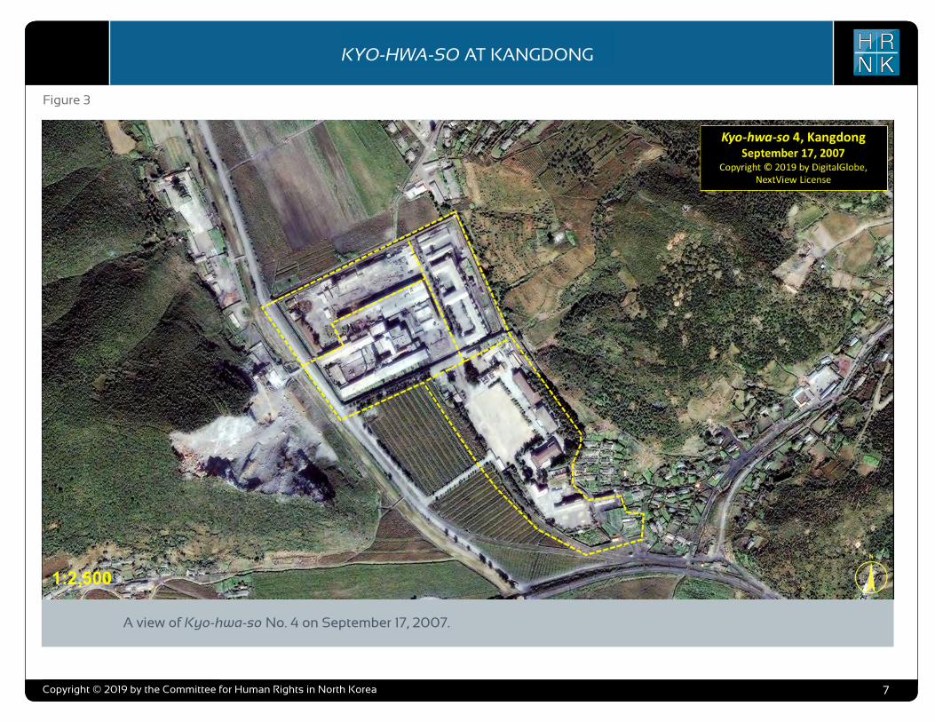
As of September 2, 2004, the prison occupied an irregular shaped area that measured approximately 524 meters by 311 meters (574 yards by 340 yards), encompassed approximately 104,640 square meters (125,150
square yards), and contained approximately 66 structures of all sizes from a limestone plant to small sheds. Located within this area was the main prison consist-ing of a 265-meter-by-190-meter high rectangular walled com-pound with four guard positions located at the four corners and a single entrance on the south side. Inside the main prison walls were plant administration and prisoner housing, a limestone plant, and support areas. Located immedi-ately south and outside the main prison and partially enclosed by
a low wall with three entrances were the prison headquarters, administration, barracks, support and housing areas. An old rail-road branch line ran adjacent to the west wall of the prison, con-necting several coal mines north of the prison to the national rail network. A short 425-meter-long, abandoned, railroad spur line is visible leading to the headquar-ters area from the south.

COPYRIGHT ©ALLSOURCE ANALYSIS, INC. 2016 3
H RN K
C H ’ O M A - B O N G R E S T R I C T E D A R E AH RN K
C A M P N O . 2 5
analysis also supports escapee and other reports indicating that Camp No. 25’s primary economic activity is focused on light industry and agriculture. Despite extensive satellite imagery coverage of the camp, AllSource is presently unable to confirm or deny escapee and open-source reports that the camp has a prisoner population of 5,000 people.
As with the analytical caution presented in previous reports (such as North Korea: Imagery Analysis Camp 16 and North Korea: Imagery Analysis of Camp 14 produced by HRNK and AllSource Analysis), it is important to reiterate that North Korean officials, especially those within the Korean People’s Army and the internal security organizations, clearly understand the importance of implementing camouflage, concealment, and deception (CCD) procedures to mask their operations and intentions.3 It would be reasonable to assume that they have done so here.
Location and Organization
Camp No. 25 is under the control of the
3 Bermudez Jr., Joseph S., Dinville, Andy and Eley, Mike. Imagery Analysis of Camp 16, (Washington, D.C.: The Committee for Human Rights in North Korea [HRNK], 2015) available at https://www.hrnk.org/uploads/pdfs/ASA_HRNK_Camp16_v8_full-res_FINAL_12_15_15.pdf and Bermudez Jr., Joseph S. Imagery Analysis: North Korea’s Camp No. 15, Update, (Washington, D.C.: HRNK, 2014) available at http://hrnk.org/uploads/pdfs/Camp%2025%20Update%20Good.pdf.
Prisons Bureau of the State Security Department (SSD), which is under the de facto control of the KWP OGD. Specifically, it is under the control of the SSD's North Hamgyong Provincial Bureau and is located approximately 7.5 km northwestof the port of Ch’ŏng-jin-si in Susŏng-dong, Ch’ŏngjin-si, Hamgyŏng-bukto.4 More specifically, it is
4 It is interesting to note that although the escapee descriptions of this facility’s mission matches that of other kwan-li-so, the physical characteristics ob-served in satellite imagery are more representative of the nation’s kyo-hwa-so, or long-term, felony penitentiaries and prison camps. David Hawk, The Hidden Gulag: Second Edition, Washington, D.C.: Committee for Human Rights in North Korea, 2012, www.hrnk.org/uploads/pdfs/HRNK_HiddenGu-lag2_Web_5-18.pdf. Another sources describes Camp No. 25 this way,
It is not structured as a village but is a fenced facility that looks like an ordinary prison camp [kyo-hwa-so] and is designed for collective living arrangements. The No. 25 [kwan-li-so] houses political prisoners only, while those who committed economic crimes are not allowed into the facility. Some inmates are released upon completion of their term as terms are fixed. Political criminals are detained alone with-out their families. …North Korean defector XXX [sic] testified, “Military personnel are sent off to the Susong kyo-hwa-so [No. 25 kwan-li-so] if their alleged crimes are of a political nature. The Susong kyo-hwa-so [No. 25 kwan-li-so] is for those serving terms of 10 years or longer, but they can return to society once they complete these terms.” It was also testified that the No. 25 kwan-li-so housed senior staff at the Provincial Party, the head of a local MPS office, and other high-ranking officials. North Korean defector XXX [sic] testified that the father of his
located on the south bank of the Sol-gol-ch’ŏn (i.e., Solgol stream) across from the village of Susŏng-dong, to which one foot and two road bridges connect it.
The date of establishment of Camp No. 25 is unclear. One report indicates that the camp was used as a prisoner-of-war camp housing South Korean soldiers at the end of the Korean War.5 This, how-ever, remains to be verified as it may not be referring to the present day camp but rather to an activity in this area. The area in which it is located has been involved in agricultural activities since at least the 1950s. Satellite imagery does indicate that Camp No. 25 was established prior to May 28, 1970, at which time it occupied an irregular shaped area that measured approximately 577 meters by 315 meters (631 yards by 344 yards) and encompassed 13.76 hectares (164,568
friend used to perform the duty of turning over Korean War POWs to South Korea, but he was arrested while attempting to cross the border at the river in Namyang, Onsung County, North Hamgyoung Province. He ended up at the No. 25 kwan-li-so in Chongjin.
Do Kyung-Ok et al., White Paper on Human Rights in North Korea 2015 (Seoul: Korea Institute for National Unification, 2015), p. 122, available at http://www.kinu.or.kr/eng/pub/pub_04_01.jsp.
5 “After the Korean War, it was used as a detention facility for South Korean POWs (Prisoners of War).” Do Kyung-Ok et al., White Paper on Human Rights in North Korea 2015 (Seoul: Korea Institute for National Unification, 2015), p. 122, available at http://www.kinu.or.kr/eng/pub/pub_04_01.jsp.
square yards) and was expanded slightly by January 27, 1976, when it measured approximately 700 meters by 315 meters (765 yards by 344 yards) and encom-passed 15.30 hectares (181,987 square yards) (Figure 1, Figure 2).6
High-resolution satellite imagery from January 18, 2003, through September 21, 2015, indicates that the camp has expanded during this period and that its primary economic activities are centered on agriculture and light industry (Figure 3 through Figure 15).
Several small villages and military facilities are located in the general area around the camp. The camp is connected to the regional electric power grid via overhead high voltage power transmis-sion cables that run from the camp to the substation approximately 1 kilometer to the southeast. It is connected to the national rail network via the station at Susŏng-dong, 800 meters to the east of the facility (Figure 16). The closest air facility to Camp No. 25 is the Korean People’s Air Force’s Sŭngam-ni Air Base, located 18 kilometers south-southwest. This is a training base, and based on its mission, organization, and location, almost certainly provides no support to Camp No. 25.
6 HRNK anticipates that we will be able to further refine the date of the camps establishment in future updates. Referenced imagery includes: KH-4B imagery dated May 28, 1970 and KH-9 (mapping camera) imagery dated January 27, 1976.
North Korea: Imagery Analysis of Camp No. 25 - Update 2
H RN KKYO-HWA-SO AT KANGDONG
Copyright © 2019 by the Committee for Human Rights in North Korea 5
A view of Kyo-hwa-so No. 4 from August 23, 1965, as seen in a declassified 3-meter resolution image collected by a CIA KH-4A reconnaissance satellite.
Copyright © 2019 by DigitalGlobe, NextView License
Figure 1

COPYRIGHT ©ALLSOURCE ANALYSIS, INC. 2016 3
H RN K
C H ’ O M A - B O N G R E S T R I C T E D A R E AH RN K
C A M P N O . 2 5
analysis also supports escapee and other reports indicating that Camp No. 25’s primary economic activity is focused on light industry and agriculture. Despite extensive satellite imagery coverage of the camp, AllSource is presently unable to confirm or deny escapee and open-source reports that the camp has a prisoner population of 5,000 people.
As with the analytical caution presented in previous reports (such as North Korea: Imagery Analysis Camp 16 and North Korea: Imagery Analysis of Camp 14 produced by HRNK and AllSource Analysis), it is important to reiterate that North Korean officials, especially those within the Korean People’s Army and the internal security organizations, clearly understand the importance of implementing camouflage, concealment, and deception (CCD) procedures to mask their operations and intentions.3 It would be reasonable to assume that they have done so here.
Location and Organization
Camp No. 25 is under the control of the
3 Bermudez Jr., Joseph S., Dinville, Andy and Eley, Mike. Imagery Analysis of Camp 16, (Washington, D.C.: The Committee for Human Rights in North Korea [HRNK], 2015) available at https://www.hrnk.org/uploads/pdfs/ASA_HRNK_Camp16_v8_full-res_FINAL_12_15_15.pdf and Bermudez Jr., Joseph S. Imagery Analysis: North Korea’s Camp No. 15, Update, (Washington, D.C.: HRNK, 2014) available at http://hrnk.org/uploads/pdfs/Camp%2025%20Update%20Good.pdf.
Prisons Bureau of the State Security Department (SSD), which is under the de facto control of the KWP OGD. Specifically, it is under the control of the SSD's North Hamgyong Provincial Bureau and is located approximately 7.5 km northwestof the port of Ch’ŏng-jin-si in Susŏng-dong, Ch’ŏngjin-si, Hamgyŏng-bukto.4 More specifically, it is
4 It is interesting to note that although the escapee descriptions of this facility’s mission matches that of other kwan-li-so, the physical characteristics ob-served in satellite imagery are more representative of the nation’s kyo-hwa-so, or long-term, felony penitentiaries and prison camps. David Hawk, The Hidden Gulag: Second Edition, Washington, D.C.: Committee for Human Rights in North Korea, 2012, www.hrnk.org/uploads/pdfs/HRNK_HiddenGu-lag2_Web_5-18.pdf. Another sources describes Camp No. 25 this way,
It is not structured as a village but is a fenced facility that looks like an ordinary prison camp [kyo-hwa-so] and is designed for collective living arrangements. The No. 25 [kwan-li-so] houses political prisoners only, while those who committed economic crimes are not allowed into the facility. Some inmates are released upon completion of their term as terms are fixed. Political criminals are detained alone with-out their families. …North Korean defector XXX [sic] testified, “Military personnel are sent off to the Susong kyo-hwa-so [No. 25 kwan-li-so] if their alleged crimes are of a political nature. The Susong kyo-hwa-so [No. 25 kwan-li-so] is for those serving terms of 10 years or longer, but they can return to society once they complete these terms.” It was also testified that the No. 25 kwan-li-so housed senior staff at the Provincial Party, the head of a local MPS office, and other high-ranking officials. North Korean defector XXX [sic] testified that the father of his
located on the south bank of the Sol-gol-ch’ŏn (i.e., Solgol stream) across from the village of Susŏng-dong, to which one foot and two road bridges connect it.
The date of establishment of Camp No. 25 is unclear. One report indicates that the camp was used as a prisoner-of-war camp housing South Korean soldiers at the end of the Korean War.5 This, how-ever, remains to be verified as it may not be referring to the present day camp but rather to an activity in this area. The area in which it is located has been involved in agricultural activities since at least the 1950s. Satellite imagery does indicate that Camp No. 25 was established prior to May 28, 1970, at which time it occupied an irregular shaped area that measured approximately 577 meters by 315 meters (631 yards by 344 yards) and encompassed 13.76 hectares (164,568
friend used to perform the duty of turning over Korean War POWs to South Korea, but he was arrested while attempting to cross the border at the river in Namyang, Onsung County, North Hamgyoung Province. He ended up at the No. 25 kwan-li-so in Chongjin.
Do Kyung-Ok et al., White Paper on Human Rights in North Korea 2015 (Seoul: Korea Institute for National Unification, 2015), p. 122, available at http://www.kinu.or.kr/eng/pub/pub_04_01.jsp.
5 “After the Korean War, it was used as a detention facility for South Korean POWs (Prisoners of War).” Do Kyung-Ok et al., White Paper on Human Rights in North Korea 2015 (Seoul: Korea Institute for National Unification, 2015), p. 122, available at http://www.kinu.or.kr/eng/pub/pub_04_01.jsp.
square yards) and was expanded slightly by January 27, 1976, when it measured approximately 700 meters by 315 meters (765 yards by 344 yards) and encom-passed 15.30 hectares (181,987 square yards) (Figure 1, Figure 2).6
High-resolution satellite imagery from January 18, 2003, through September 21, 2015, indicates that the camp has expanded during this period and that its primary economic activities are centered on agriculture and light industry (Figure 3 through Figure 15).
Several small villages and military facilities are located in the general area around the camp. The camp is connected to the regional electric power grid via overhead high voltage power transmis-sion cables that run from the camp to the substation approximately 1 kilometer to the southeast. It is connected to the national rail network via the station at Susŏng-dong, 800 meters to the east of the facility (Figure 16). The closest air facility to Camp No. 25 is the Korean People’s Air Force’s Sŭngam-ni Air Base, located 18 kilometers south-southwest. This is a training base, and based on its mission, organization, and location, almost certainly provides no support to Camp No. 25.
6 HRNK anticipates that we will be able to further refine the date of the camps establishment in future updates. Referenced imagery includes: KH-4B imagery dated May 28, 1970 and KH-9 (mapping camera) imagery dated January 27, 1976.
North Korea: Imagery Analysis of Camp No. 25 - Update 2
H RN KKYO-HWA-SO AT KANGDONG
Copyright © 2019 by the Committee for Human Rights in North Korea 6
A view of Kyo-hwa-so No. 4 on September 2, 2004 showing the general arrangement of the facility and the changes that occurred from 1965-2004.
Figure 2
COPYRIGHT ©ALLSOURCE ANALYSIS, INC. 2016 3
H RN K
C H ’ O M A - B O N G R E S T R I C T E D A R E AH RN K
C A M P N O . 2 5
analysis also supports escapee and other reports indicating that Camp No. 25’s primary economic activity is focused on light industry and agriculture. Despite extensive satellite imagery coverage of the camp, AllSource is presently unable to confirm or deny escapee and open-source reports that the camp has a prisoner population of 5,000 people.
As with the analytical caution presented in previous reports (such as North Korea: Imagery Analysis Camp 16 and North Korea: Imagery Analysis of Camp 14 produced by HRNK and AllSource Analysis), it is important to reiterate that North Korean officials, especially those within the Korean People’s Army and the internal security organizations, clearly understand the importance of implementing camouflage, concealment, and deception (CCD) procedures to mask their operations and intentions.3 It would be reasonable to assume that they have done so here.
Location and Organization
Camp No. 25 is under the control of the
3 Bermudez Jr., Joseph S., Dinville, Andy and Eley, Mike. Imagery Analysis of Camp 16, (Washington, D.C.: The Committee for Human Rights in North Korea [HRNK], 2015) available at https://www.hrnk.org/uploads/pdfs/ASA_HRNK_Camp16_v8_full-res_FINAL_12_15_15.pdf and Bermudez Jr., Joseph S. Imagery Analysis: North Korea’s Camp No. 15, Update, (Washington, D.C.: HRNK, 2014) available at http://hrnk.org/uploads/pdfs/Camp%2025%20Update%20Good.pdf.
Prisons Bureau of the State Security Department (SSD), which is under the de facto control of the KWP OGD. Specifically, it is under the control of the SSD's North Hamgyong Provincial Bureau and is located approximately 7.5 km northwestof the port of Ch’ŏng-jin-si in Susŏng-dong, Ch’ŏngjin-si, Hamgyŏng-bukto.4 More specifically, it is
4 It is interesting to note that although the escapee descriptions of this facility’s mission matches that of other kwan-li-so, the physical characteristics ob-served in satellite imagery are more representative of the nation’s kyo-hwa-so, or long-term, felony penitentiaries and prison camps. David Hawk, The Hidden Gulag: Second Edition, Washington, D.C.: Committee for Human Rights in North Korea, 2012, www.hrnk.org/uploads/pdfs/HRNK_HiddenGu-lag2_Web_5-18.pdf. Another sources describes Camp No. 25 this way,
It is not structured as a village but is a fenced facility that looks like an ordinary prison camp [kyo-hwa-so] and is designed for collective living arrangements. The No. 25 [kwan-li-so] houses political prisoners only, while those who committed economic crimes are not allowed into the facility. Some inmates are released upon completion of their term as terms are fixed. Political criminals are detained alone with-out their families. …North Korean defector XXX [sic] testified, “Military personnel are sent off to the Susong kyo-hwa-so [No. 25 kwan-li-so] if their alleged crimes are of a political nature. The Susong kyo-hwa-so [No. 25 kwan-li-so] is for those serving terms of 10 years or longer, but they can return to society once they complete these terms.” It was also testified that the No. 25 kwan-li-so housed senior staff at the Provincial Party, the head of a local MPS office, and other high-ranking officials. North Korean defector XXX [sic] testified that the father of his
located on the south bank of the Sol-gol-ch’ŏn (i.e., Solgol stream) across from the village of Susŏng-dong, to which one foot and two road bridges connect it.
The date of establishment of Camp No. 25 is unclear. One report indicates that the camp was used as a prisoner-of-war camp housing South Korean soldiers at the end of the Korean War.5 This, how-ever, remains to be verified as it may not be referring to the present day camp but rather to an activity in this area. The area in which it is located has been involved in agricultural activities since at least the 1950s. Satellite imagery does indicate that Camp No. 25 was established prior to May 28, 1970, at which time it occupied an irregular shaped area that measured approximately 577 meters by 315 meters (631 yards by 344 yards) and encompassed 13.76 hectares (164,568
friend used to perform the duty of turning over Korean War POWs to South Korea, but he was arrested while attempting to cross the border at the river in Namyang, Onsung County, North Hamgyoung Province. He ended up at the No. 25 kwan-li-so in Chongjin.
Do Kyung-Ok et al., White Paper on Human Rights in North Korea 2015 (Seoul: Korea Institute for National Unification, 2015), p. 122, available at http://www.kinu.or.kr/eng/pub/pub_04_01.jsp.
5 “After the Korean War, it was used as a detention facility for South Korean POWs (Prisoners of War).” Do Kyung-Ok et al., White Paper on Human Rights in North Korea 2015 (Seoul: Korea Institute for National Unification, 2015), p. 122, available at http://www.kinu.or.kr/eng/pub/pub_04_01.jsp.
square yards) and was expanded slightly by January 27, 1976, when it measured approximately 700 meters by 315 meters (765 yards by 344 yards) and encom-passed 15.30 hectares (181,987 square yards) (Figure 1, Figure 2).6
High-resolution satellite imagery from January 18, 2003, through September 21, 2015, indicates that the camp has expanded during this period and that its primary economic activities are centered on agriculture and light industry (Figure 3 through Figure 15).
Several small villages and military facilities are located in the general area around the camp. The camp is connected to the regional electric power grid via overhead high voltage power transmis-sion cables that run from the camp to the substation approximately 1 kilometer to the southeast. It is connected to the national rail network via the station at Susŏng-dong, 800 meters to the east of the facility (Figure 16). The closest air facility to Camp No. 25 is the Korean People’s Air Force’s Sŭngam-ni Air Base, located 18 kilometers south-southwest. This is a training base, and based on its mission, organization, and location, almost certainly provides no support to Camp No. 25.
6 HRNK anticipates that we will be able to further refine the date of the camps establishment in future updates. Referenced imagery includes: KH-4B imagery dated May 28, 1970 and KH-9 (mapping camera) imagery dated January 27, 1976.
North Korea: Imagery Analysis of Camp No. 25 - Update 2
H RN KKYO-HWA-SO AT KANGDONG
Copyright © 2019 by the Committee for Human Rights in North Korea 7
A view of Kyo-hwa-so No. 4 on September 17, 2007.
Figure 3

COPYRIGHT ©ALLSOURCE ANALYSIS, INC. 2016 3
H RN K
C H ’ O M A - B O N G R E S T R I C T E D A R E AH RN K
C A M P N O . 2 5
analysis also supports escapee and other reports indicating that Camp No. 25’s primary economic activity is focused on light industry and agriculture. Despite extensive satellite imagery coverage of the camp, AllSource is presently unable to confirm or deny escapee and open-source reports that the camp has a prisoner population of 5,000 people.
As with the analytical caution presented in previous reports (such as North Korea: Imagery Analysis Camp 16 and North Korea: Imagery Analysis of Camp 14 produced by HRNK and AllSource Analysis), it is important to reiterate that North Korean officials, especially those within the Korean People’s Army and the internal security organizations, clearly understand the importance of implementing camouflage, concealment, and deception (CCD) procedures to mask their operations and intentions.3 It would be reasonable to assume that they have done so here.
Location and Organization
Camp No. 25 is under the control of the
3 Bermudez Jr., Joseph S., Dinville, Andy and Eley, Mike. Imagery Analysis of Camp 16, (Washington, D.C.: The Committee for Human Rights in North Korea [HRNK], 2015) available at https://www.hrnk.org/uploads/pdfs/ASA_HRNK_Camp16_v8_full-res_FINAL_12_15_15.pdf and Bermudez Jr., Joseph S. Imagery Analysis: North Korea’s Camp No. 15, Update, (Washington, D.C.: HRNK, 2014) available at http://hrnk.org/uploads/pdfs/Camp%2025%20Update%20Good.pdf.
Prisons Bureau of the State Security Department (SSD), which is under the de facto control of the KWP OGD. Specifically, it is under the control of the SSD's North Hamgyong Provincial Bureau and is located approximately 7.5 km northwestof the port of Ch’ŏng-jin-si in Susŏng-dong, Ch’ŏngjin-si, Hamgyŏng-bukto.4 More specifically, it is
4 It is interesting to note that although the escapee descriptions of this facility’s mission matches that of other kwan-li-so, the physical characteristics ob-served in satellite imagery are more representative of the nation’s kyo-hwa-so, or long-term, felony penitentiaries and prison camps. David Hawk, The Hidden Gulag: Second Edition, Washington, D.C.: Committee for Human Rights in North Korea, 2012, www.hrnk.org/uploads/pdfs/HRNK_HiddenGu-lag2_Web_5-18.pdf. Another sources describes Camp No. 25 this way,
It is not structured as a village but is a fenced facility that looks like an ordinary prison camp [kyo-hwa-so] and is designed for collective living arrangements. The No. 25 [kwan-li-so] houses political prisoners only, while those who committed economic crimes are not allowed into the facility. Some inmates are released upon completion of their term as terms are fixed. Political criminals are detained alone with-out their families. …North Korean defector XXX [sic] testified, “Military personnel are sent off to the Susong kyo-hwa-so [No. 25 kwan-li-so] if their alleged crimes are of a political nature. The Susong kyo-hwa-so [No. 25 kwan-li-so] is for those serving terms of 10 years or longer, but they can return to society once they complete these terms.” It was also testified that the No. 25 kwan-li-so housed senior staff at the Provincial Party, the head of a local MPS office, and other high-ranking officials. North Korean defector XXX [sic] testified that the father of his
located on the south bank of the Sol-gol-ch’ŏn (i.e., Solgol stream) across from the village of Susŏng-dong, to which one foot and two road bridges connect it.
The date of establishment of Camp No. 25 is unclear. One report indicates that the camp was used as a prisoner-of-war camp housing South Korean soldiers at the end of the Korean War.5 This, how-ever, remains to be verified as it may not be referring to the present day camp but rather to an activity in this area. The area in which it is located has been involved in agricultural activities since at least the 1950s. Satellite imagery does indicate that Camp No. 25 was established prior to May 28, 1970, at which time it occupied an irregular shaped area that measured approximately 577 meters by 315 meters (631 yards by 344 yards) and encompassed 13.76 hectares (164,568
friend used to perform the duty of turning over Korean War POWs to South Korea, but he was arrested while attempting to cross the border at the river in Namyang, Onsung County, North Hamgyoung Province. He ended up at the No. 25 kwan-li-so in Chongjin.
Do Kyung-Ok et al., White Paper on Human Rights in North Korea 2015 (Seoul: Korea Institute for National Unification, 2015), p. 122, available at http://www.kinu.or.kr/eng/pub/pub_04_01.jsp.
5 “After the Korean War, it was used as a detention facility for South Korean POWs (Prisoners of War).” Do Kyung-Ok et al., White Paper on Human Rights in North Korea 2015 (Seoul: Korea Institute for National Unification, 2015), p. 122, available at http://www.kinu.or.kr/eng/pub/pub_04_01.jsp.
square yards) and was expanded slightly by January 27, 1976, when it measured approximately 700 meters by 315 meters (765 yards by 344 yards) and encom-passed 15.30 hectares (181,987 square yards) (Figure 1, Figure 2).6
High-resolution satellite imagery from January 18, 2003, through September 21, 2015, indicates that the camp has expanded during this period and that its primary economic activities are centered on agriculture and light industry (Figure 3 through Figure 15).
Several small villages and military facilities are located in the general area around the camp. The camp is connected to the regional electric power grid via overhead high voltage power transmis-sion cables that run from the camp to the substation approximately 1 kilometer to the southeast. It is connected to the national rail network via the station at Susŏng-dong, 800 meters to the east of the facility (Figure 16). The closest air facility to Camp No. 25 is the Korean People’s Air Force’s Sŭngam-ni Air Base, located 18 kilometers south-southwest. This is a training base, and based on its mission, organization, and location, almost certainly provides no support to Camp No. 25.
6 HRNK anticipates that we will be able to further refine the date of the camps establishment in future updates. Referenced imagery includes: KH-4B imagery dated May 28, 1970 and KH-9 (mapping camera) imagery dated January 27, 1976.
North Korea: Imagery Analysis of Camp No. 25 - Update 2
H RN KKYO-HWA-SO AT KANGDONG
Copyright © 2019 by the Committee for Human Rights in North Korea 8
A view of Kyo-hwa-so No. 4 on January 31, 2009 showing the addition of two new buildings.
Figure 4
COPYRIGHT ©ALLSOURCE ANALYSIS, INC. 2016 3
H RN K
C H ’ O M A - B O N G R E S T R I C T E D A R E AH RN K
C A M P N O . 2 5
analysis also supports escapee and other reports indicating that Camp No. 25’s primary economic activity is focused on light industry and agriculture. Despite extensive satellite imagery coverage of the camp, AllSource is presently unable to confirm or deny escapee and open-source reports that the camp has a prisoner population of 5,000 people.
As with the analytical caution presented in previous reports (such as North Korea: Imagery Analysis Camp 16 and North Korea: Imagery Analysis of Camp 14 produced by HRNK and AllSource Analysis), it is important to reiterate that North Korean officials, especially those within the Korean People’s Army and the internal security organizations, clearly understand the importance of implementing camouflage, concealment, and deception (CCD) procedures to mask their operations and intentions.3 It would be reasonable to assume that they have done so here.
Location and Organization
Camp No. 25 is under the control of the
3 Bermudez Jr., Joseph S., Dinville, Andy and Eley, Mike. Imagery Analysis of Camp 16, (Washington, D.C.: The Committee for Human Rights in North Korea [HRNK], 2015) available at https://www.hrnk.org/uploads/pdfs/ASA_HRNK_Camp16_v8_full-res_FINAL_12_15_15.pdf and Bermudez Jr., Joseph S. Imagery Analysis: North Korea’s Camp No. 15, Update, (Washington, D.C.: HRNK, 2014) available at http://hrnk.org/uploads/pdfs/Camp%2025%20Update%20Good.pdf.
Prisons Bureau of the State Security Department (SSD), which is under the de facto control of the KWP OGD. Specifically, it is under the control of the SSD's North Hamgyong Provincial Bureau and is located approximately 7.5 km northwestof the port of Ch’ŏng-jin-si in Susŏng-dong, Ch’ŏngjin-si, Hamgyŏng-bukto.4 More specifically, it is
4 It is interesting to note that although the escapee descriptions of this facility’s mission matches that of other kwan-li-so, the physical characteristics ob-served in satellite imagery are more representative of the nation’s kyo-hwa-so, or long-term, felony penitentiaries and prison camps. David Hawk, The Hidden Gulag: Second Edition, Washington, D.C.: Committee for Human Rights in North Korea, 2012, www.hrnk.org/uploads/pdfs/HRNK_HiddenGu-lag2_Web_5-18.pdf. Another sources describes Camp No. 25 this way,
It is not structured as a village but is a fenced facility that looks like an ordinary prison camp [kyo-hwa-so] and is designed for collective living arrangements. The No. 25 [kwan-li-so] houses political prisoners only, while those who committed economic crimes are not allowed into the facility. Some inmates are released upon completion of their term as terms are fixed. Political criminals are detained alone with-out their families. …North Korean defector XXX [sic] testified, “Military personnel are sent off to the Susong kyo-hwa-so [No. 25 kwan-li-so] if their alleged crimes are of a political nature. The Susong kyo-hwa-so [No. 25 kwan-li-so] is for those serving terms of 10 years or longer, but they can return to society once they complete these terms.” It was also testified that the No. 25 kwan-li-so housed senior staff at the Provincial Party, the head of a local MPS office, and other high-ranking officials. North Korean defector XXX [sic] testified that the father of his
located on the south bank of the Sol-gol-ch’ŏn (i.e., Solgol stream) across from the village of Susŏng-dong, to which one foot and two road bridges connect it.
The date of establishment of Camp No. 25 is unclear. One report indicates that the camp was used as a prisoner-of-war camp housing South Korean soldiers at the end of the Korean War.5 This, how-ever, remains to be verified as it may not be referring to the present day camp but rather to an activity in this area. The area in which it is located has been involved in agricultural activities since at least the 1950s. Satellite imagery does indicate that Camp No. 25 was established prior to May 28, 1970, at which time it occupied an irregular shaped area that measured approximately 577 meters by 315 meters (631 yards by 344 yards) and encompassed 13.76 hectares (164,568
friend used to perform the duty of turning over Korean War POWs to South Korea, but he was arrested while attempting to cross the border at the river in Namyang, Onsung County, North Hamgyoung Province. He ended up at the No. 25 kwan-li-so in Chongjin.
Do Kyung-Ok et al., White Paper on Human Rights in North Korea 2015 (Seoul: Korea Institute for National Unification, 2015), p. 122, available at http://www.kinu.or.kr/eng/pub/pub_04_01.jsp.
5 “After the Korean War, it was used as a detention facility for South Korean POWs (Prisoners of War).” Do Kyung-Ok et al., White Paper on Human Rights in North Korea 2015 (Seoul: Korea Institute for National Unification, 2015), p. 122, available at http://www.kinu.or.kr/eng/pub/pub_04_01.jsp.
square yards) and was expanded slightly by January 27, 1976, when it measured approximately 700 meters by 315 meters (765 yards by 344 yards) and encom-passed 15.30 hectares (181,987 square yards) (Figure 1, Figure 2).6
High-resolution satellite imagery from January 18, 2003, through September 21, 2015, indicates that the camp has expanded during this period and that its primary economic activities are centered on agriculture and light industry (Figure 3 through Figure 15).
Several small villages and military facilities are located in the general area around the camp. The camp is connected to the regional electric power grid via overhead high voltage power transmis-sion cables that run from the camp to the substation approximately 1 kilometer to the southeast. It is connected to the national rail network via the station at Susŏng-dong, 800 meters to the east of the facility (Figure 16). The closest air facility to Camp No. 25 is the Korean People’s Air Force’s Sŭngam-ni Air Base, located 18 kilometers south-southwest. This is a training base, and based on its mission, organization, and location, almost certainly provides no support to Camp No. 25.
6 HRNK anticipates that we will be able to further refine the date of the camps establishment in future updates. Referenced imagery includes: KH-4B imagery dated May 28, 1970 and KH-9 (mapping camera) imagery dated January 27, 1976.
North Korea: Imagery Analysis of Camp No. 25 - Update 2
H RN KKYO-HWA-SO AT KANGDONG
Copyright © 2019 by the Committee for Human Rights in North Korea 9
NORTH KOREA’S LONG-TERM PRISON-LABOR FACILITY (KYO-HWA-SO) AT KANGDONG
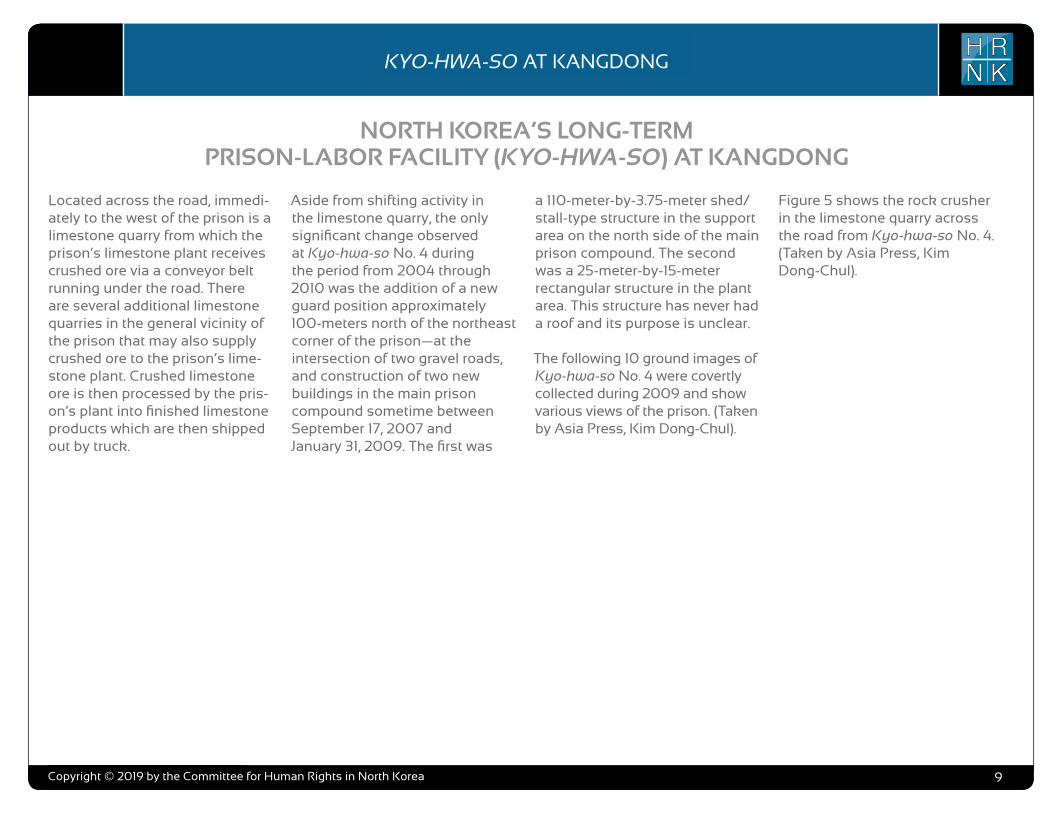
Located across the road, immedi-ately to the west of the prison is a limestone quarry from which the prison’s limestone plant receives crushed ore via a conveyor belt running under the road. There are several additional limestone quarries in the general vicinity of the prison that may also supply crushed ore to the prison’s lime-stone plant. Crushed limestone ore is then processed by the pris-on’s plant into finished limestone products which are then shipped out by truck.
Aside from shifting activity in the limestone quarry, the only significant change observed at Kyo-hwa-so No. 4 during the period from 2004 through 2010 was the addition of a new guard position approximately 100-meters north of the northeast corner of the prison—at the intersection of two gravel roads, and construction of two new buildings in the main prison compound sometime between September 17, 2007 and January 31, 2009. The first was
a 110-meter-by-3.75-meter shed/stall-type structure in the support area on the north side of the main prison compound. The second was a 25-meter-by-15-meter rectangular structure in the plant area. This structure has never had a roof and its purpose is unclear.
The following 10 ground images of Kyo-hwa-so No. 4 were covertly collected during 2009 and show various views of the prison. (Taken by Asia Press, Kim Dong-Chul).
Figure 5 shows the rock crusher in the limestone quarry across the road from Kyo-hwa-so No. 4. (Taken by Asia Press, Kim Dong-Chul).

COPYRIGHT ©ALLSOURCE ANALYSIS, INC. 2016 3
H RN K
C H ’ O M A - B O N G R E S T R I C T E D A R E AH RN K
C A M P N O . 2 5
analysis also supports escapee and other reports indicating that Camp No. 25’s primary economic activity is focused on light industry and agriculture. Despite extensive satellite imagery coverage of the camp, AllSource is presently unable to confirm or deny escapee and open-source reports that the camp has a prisoner population of 5,000 people.
As with the analytical caution presented in previous reports (such as North Korea: Imagery Analysis Camp 16 and North Korea: Imagery Analysis of Camp 14 produced by HRNK and AllSource Analysis), it is important to reiterate that North Korean officials, especially those within the Korean People’s Army and the internal security organizations, clearly understand the importance of implementing camouflage, concealment, and deception (CCD) procedures to mask their operations and intentions.3 It would be reasonable to assume that they have done so here.
Location and Organization
Camp No. 25 is under the control of the
3 Bermudez Jr., Joseph S., Dinville, Andy and Eley, Mike. Imagery Analysis of Camp 16, (Washington, D.C.: The Committee for Human Rights in North Korea [HRNK], 2015) available at https://www.hrnk.org/uploads/pdfs/ASA_HRNK_Camp16_v8_full-res_FINAL_12_15_15.pdf and Bermudez Jr., Joseph S. Imagery Analysis: North Korea’s Camp No. 15, Update, (Washington, D.C.: HRNK, 2014) available at http://hrnk.org/uploads/pdfs/Camp%2025%20Update%20Good.pdf.
Prisons Bureau of the State Security Department (SSD), which is under the de facto control of the KWP OGD. Specifically, it is under the control of the SSD's North Hamgyong Provincial Bureau and is located approximately 7.5 km northwestof the port of Ch’ŏng-jin-si in Susŏng-dong, Ch’ŏngjin-si, Hamgyŏng-bukto.4 More specifically, it is
4 It is interesting to note that although the escapee descriptions of this facility’s mission matches that of other kwan-li-so, the physical characteristics ob-served in satellite imagery are more representative of the nation’s kyo-hwa-so, or long-term, felony penitentiaries and prison camps. David Hawk, The Hidden Gulag: Second Edition, Washington, D.C.: Committee for Human Rights in North Korea, 2012, www.hrnk.org/uploads/pdfs/HRNK_HiddenGu-lag2_Web_5-18.pdf. Another sources describes Camp No. 25 this way,
It is not structured as a village but is a fenced facility that looks like an ordinary prison camp [kyo-hwa-so] and is designed for collective living arrangements. The No. 25 [kwan-li-so] houses political prisoners only, while those who committed economic crimes are not allowed into the facility. Some inmates are released upon completion of their term as terms are fixed. Political criminals are detained alone with-out their families. …North Korean defector XXX [sic] testified, “Military personnel are sent off to the Susong kyo-hwa-so [No. 25 kwan-li-so] if their alleged crimes are of a political nature. The Susong kyo-hwa-so [No. 25 kwan-li-so] is for those serving terms of 10 years or longer, but they can return to society once they complete these terms.” It was also testified that the No. 25 kwan-li-so housed senior staff at the Provincial Party, the head of a local MPS office, and other high-ranking officials. North Korean defector XXX [sic] testified that the father of his
located on the south bank of the Sol-gol-ch’ŏn (i.e., Solgol stream) across from the village of Susŏng-dong, to which one foot and two road bridges connect it.
The date of establishment of Camp No. 25 is unclear. One report indicates that the camp was used as a prisoner-of-war camp housing South Korean soldiers at the end of the Korean War.5 This, how-ever, remains to be verified as it may not be referring to the present day camp but rather to an activity in this area. The area in which it is located has been involved in agricultural activities since at least the 1950s. Satellite imagery does indicate that Camp No. 25 was established prior to May 28, 1970, at which time it occupied an irregular shaped area that measured approximately 577 meters by 315 meters (631 yards by 344 yards) and encompassed 13.76 hectares (164,568
friend used to perform the duty of turning over Korean War POWs to South Korea, but he was arrested while attempting to cross the border at the river in Namyang, Onsung County, North Hamgyoung Province. He ended up at the No. 25 kwan-li-so in Chongjin.
Do Kyung-Ok et al., White Paper on Human Rights in North Korea 2015 (Seoul: Korea Institute for National Unification, 2015), p. 122, available at http://www.kinu.or.kr/eng/pub/pub_04_01.jsp.
5 “After the Korean War, it was used as a detention facility for South Korean POWs (Prisoners of War).” Do Kyung-Ok et al., White Paper on Human Rights in North Korea 2015 (Seoul: Korea Institute for National Unification, 2015), p. 122, available at http://www.kinu.or.kr/eng/pub/pub_04_01.jsp.
square yards) and was expanded slightly by January 27, 1976, when it measured approximately 700 meters by 315 meters (765 yards by 344 yards) and encom-passed 15.30 hectares (181,987 square yards) (Figure 1, Figure 2).6
High-resolution satellite imagery from January 18, 2003, through September 21, 2015, indicates that the camp has expanded during this period and that its primary economic activities are centered on agriculture and light industry (Figure 3 through Figure 15).
Several small villages and military facilities are located in the general area around the camp. The camp is connected to the regional electric power grid via overhead high voltage power transmis-sion cables that run from the camp to the substation approximately 1 kilometer to the southeast. It is connected to the national rail network via the station at Susŏng-dong, 800 meters to the east of the facility (Figure 16). The closest air facility to Camp No. 25 is the Korean People’s Air Force’s Sŭngam-ni Air Base, located 18 kilometers south-southwest. This is a training base, and based on its mission, organization, and location, almost certainly provides no support to Camp No. 25.
6 HRNK anticipates that we will be able to further refine the date of the camps establishment in future updates. Referenced imagery includes: KH-4B imagery dated May 28, 1970 and KH-9 (mapping camera) imagery dated January 27, 1976.
North Korea: Imagery Analysis of Camp No. 25 - Update 2
H RN KKYO-HWA-SO AT KANGDONG
Copyright © 2019 by the Committee for Human Rights in North Korea 10
Figure 5
Taken by Asia Press, Kim Dong-Chul

COPYRIGHT ©ALLSOURCE ANALYSIS, INC. 2016 3
H RN K
C H ’ O M A - B O N G R E S T R I C T E D A R E AH RN K
C A M P N O . 2 5
analysis also supports escapee and other reports indicating that Camp No. 25’s primary economic activity is focused on light industry and agriculture. Despite extensive satellite imagery coverage of the camp, AllSource is presently unable to confirm or deny escapee and open-source reports that the camp has a prisoner population of 5,000 people.
As with the analytical caution presented in previous reports (such as North Korea: Imagery Analysis Camp 16 and North Korea: Imagery Analysis of Camp 14 produced by HRNK and AllSource Analysis), it is important to reiterate that North Korean officials, especially those within the Korean People’s Army and the internal security organizations, clearly understand the importance of implementing camouflage, concealment, and deception (CCD) procedures to mask their operations and intentions.3 It would be reasonable to assume that they have done so here.
Location and Organization
Camp No. 25 is under the control of the
3 Bermudez Jr., Joseph S., Dinville, Andy and Eley, Mike. Imagery Analysis of Camp 16, (Washington, D.C.: The Committee for Human Rights in North Korea [HRNK], 2015) available at https://www.hrnk.org/uploads/pdfs/ASA_HRNK_Camp16_v8_full-res_FINAL_12_15_15.pdf and Bermudez Jr., Joseph S. Imagery Analysis: North Korea’s Camp No. 15, Update, (Washington, D.C.: HRNK, 2014) available at http://hrnk.org/uploads/pdfs/Camp%2025%20Update%20Good.pdf.
Prisons Bureau of the State Security Department (SSD), which is under the de facto control of the KWP OGD. Specifically, it is under the control of the SSD's North Hamgyong Provincial Bureau and is located approximately 7.5 km northwestof the port of Ch’ŏng-jin-si in Susŏng-dong, Ch’ŏngjin-si, Hamgyŏng-bukto.4 More specifically, it is
4 It is interesting to note that although the escapee descriptions of this facility’s mission matches that of other kwan-li-so, the physical characteristics ob-served in satellite imagery are more representative of the nation’s kyo-hwa-so, or long-term, felony penitentiaries and prison camps. David Hawk, The Hidden Gulag: Second Edition, Washington, D.C.: Committee for Human Rights in North Korea, 2012, www.hrnk.org/uploads/pdfs/HRNK_HiddenGu-lag2_Web_5-18.pdf. Another sources describes Camp No. 25 this way,
It is not structured as a village but is a fenced facility that looks like an ordinary prison camp [kyo-hwa-so] and is designed for collective living arrangements. The No. 25 [kwan-li-so] houses political prisoners only, while those who committed economic crimes are not allowed into the facility. Some inmates are released upon completion of their term as terms are fixed. Political criminals are detained alone with-out their families. …North Korean defector XXX [sic] testified, “Military personnel are sent off to the Susong kyo-hwa-so [No. 25 kwan-li-so] if their alleged crimes are of a political nature. The Susong kyo-hwa-so [No. 25 kwan-li-so] is for those serving terms of 10 years or longer, but they can return to society once they complete these terms.” It was also testified that the No. 25 kwan-li-so housed senior staff at the Provincial Party, the head of a local MPS office, and other high-ranking officials. North Korean defector XXX [sic] testified that the father of his
located on the south bank of the Sol-gol-ch’ŏn (i.e., Solgol stream) across from the village of Susŏng-dong, to which one foot and two road bridges connect it.
The date of establishment of Camp No. 25 is unclear. One report indicates that the camp was used as a prisoner-of-war camp housing South Korean soldiers at the end of the Korean War.5 This, how-ever, remains to be verified as it may not be referring to the present day camp but rather to an activity in this area. The area in which it is located has been involved in agricultural activities since at least the 1950s. Satellite imagery does indicate that Camp No. 25 was established prior to May 28, 1970, at which time it occupied an irregular shaped area that measured approximately 577 meters by 315 meters (631 yards by 344 yards) and encompassed 13.76 hectares (164,568
friend used to perform the duty of turning over Korean War POWs to South Korea, but he was arrested while attempting to cross the border at the river in Namyang, Onsung County, North Hamgyoung Province. He ended up at the No. 25 kwan-li-so in Chongjin.
Do Kyung-Ok et al., White Paper on Human Rights in North Korea 2015 (Seoul: Korea Institute for National Unification, 2015), p. 122, available at http://www.kinu.or.kr/eng/pub/pub_04_01.jsp.
5 “After the Korean War, it was used as a detention facility for South Korean POWs (Prisoners of War).” Do Kyung-Ok et al., White Paper on Human Rights in North Korea 2015 (Seoul: Korea Institute for National Unification, 2015), p. 122, available at http://www.kinu.or.kr/eng/pub/pub_04_01.jsp.
square yards) and was expanded slightly by January 27, 1976, when it measured approximately 700 meters by 315 meters (765 yards by 344 yards) and encom-passed 15.30 hectares (181,987 square yards) (Figure 1, Figure 2).6
High-resolution satellite imagery from January 18, 2003, through September 21, 2015, indicates that the camp has expanded during this period and that its primary economic activities are centered on agriculture and light industry (Figure 3 through Figure 15).
Several small villages and military facilities are located in the general area around the camp. The camp is connected to the regional electric power grid via overhead high voltage power transmis-sion cables that run from the camp to the substation approximately 1 kilometer to the southeast. It is connected to the national rail network via the station at Susŏng-dong, 800 meters to the east of the facility (Figure 16). The closest air facility to Camp No. 25 is the Korean People’s Air Force’s Sŭngam-ni Air Base, located 18 kilometers south-southwest. This is a training base, and based on its mission, organization, and location, almost certainly provides no support to Camp No. 25.
6 HRNK anticipates that we will be able to further refine the date of the camps establishment in future updates. Referenced imagery includes: KH-4B imagery dated May 28, 1970 and KH-9 (mapping camera) imagery dated January 27, 1976.
North Korea: Imagery Analysis of Camp No. 25 - Update 2
H RN KKYO-HWA-SO AT KANGDONG
Copyright © 2019 by the Committee for Human Rights in North Korea 11
Figure 6
Taken by Asia Press, Kim Dong-Chul
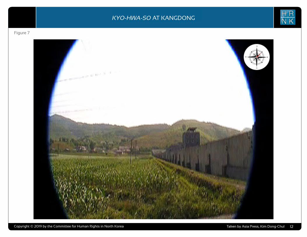
COPYRIGHT ©ALLSOURCE ANALYSIS, INC. 2016 3
H RN K
C H ’ O M A - B O N G R E S T R I C T E D A R E AH RN K
C A M P N O . 2 5
analysis also supports escapee and other reports indicating that Camp No. 25’s primary economic activity is focused on light industry and agriculture. Despite extensive satellite imagery coverage of the camp, AllSource is presently unable to confirm or deny escapee and open-source reports that the camp has a prisoner population of 5,000 people.
As with the analytical caution presented in previous reports (such as North Korea: Imagery Analysis Camp 16 and North Korea: Imagery Analysis of Camp 14 produced by HRNK and AllSource Analysis), it is important to reiterate that North Korean officials, especially those within the Korean People’s Army and the internal security organizations, clearly understand the importance of implementing camouflage, concealment, and deception (CCD) procedures to mask their operations and intentions.3 It would be reasonable to assume that they have done so here.
Location and Organization
Camp No. 25 is under the control of the
3 Bermudez Jr., Joseph S., Dinville, Andy and Eley, Mike. Imagery Analysis of Camp 16, (Washington, D.C.: The Committee for Human Rights in North Korea [HRNK], 2015) available at https://www.hrnk.org/uploads/pdfs/ASA_HRNK_Camp16_v8_full-res_FINAL_12_15_15.pdf and Bermudez Jr., Joseph S. Imagery Analysis: North Korea’s Camp No. 15, Update, (Washington, D.C.: HRNK, 2014) available at http://hrnk.org/uploads/pdfs/Camp%2025%20Update%20Good.pdf.
Prisons Bureau of the State Security Department (SSD), which is under the de facto control of the KWP OGD. Specifically, it is under the control of the SSD's North Hamgyong Provincial Bureau and is located approximately 7.5 km northwestof the port of Ch’ŏng-jin-si in Susŏng-dong, Ch’ŏngjin-si, Hamgyŏng-bukto.4 More specifically, it is
4 It is interesting to note that although the escapee descriptions of this facility’s mission matches that of other kwan-li-so, the physical characteristics ob-served in satellite imagery are more representative of the nation’s kyo-hwa-so, or long-term, felony penitentiaries and prison camps. David Hawk, The Hidden Gulag: Second Edition, Washington, D.C.: Committee for Human Rights in North Korea, 2012, www.hrnk.org/uploads/pdfs/HRNK_HiddenGu-lag2_Web_5-18.pdf. Another sources describes Camp No. 25 this way,
It is not structured as a village but is a fenced facility that looks like an ordinary prison camp [kyo-hwa-so] and is designed for collective living arrangements. The No. 25 [kwan-li-so] houses political prisoners only, while those who committed economic crimes are not allowed into the facility. Some inmates are released upon completion of their term as terms are fixed. Political criminals are detained alone with-out their families. …North Korean defector XXX [sic] testified, “Military personnel are sent off to the Susong kyo-hwa-so [No. 25 kwan-li-so] if their alleged crimes are of a political nature. The Susong kyo-hwa-so [No. 25 kwan-li-so] is for those serving terms of 10 years or longer, but they can return to society once they complete these terms.” It was also testified that the No. 25 kwan-li-so housed senior staff at the Provincial Party, the head of a local MPS office, and other high-ranking officials. North Korean defector XXX [sic] testified that the father of his
located on the south bank of the Sol-gol-ch’ŏn (i.e., Solgol stream) across from the village of Susŏng-dong, to which one foot and two road bridges connect it.
The date of establishment of Camp No. 25 is unclear. One report indicates that the camp was used as a prisoner-of-war camp housing South Korean soldiers at the end of the Korean War.5 This, how-ever, remains to be verified as it may not be referring to the present day camp but rather to an activity in this area. The area in which it is located has been involved in agricultural activities since at least the 1950s. Satellite imagery does indicate that Camp No. 25 was established prior to May 28, 1970, at which time it occupied an irregular shaped area that measured approximately 577 meters by 315 meters (631 yards by 344 yards) and encompassed 13.76 hectares (164,568
friend used to perform the duty of turning over Korean War POWs to South Korea, but he was arrested while attempting to cross the border at the river in Namyang, Onsung County, North Hamgyoung Province. He ended up at the No. 25 kwan-li-so in Chongjin.
Do Kyung-Ok et al., White Paper on Human Rights in North Korea 2015 (Seoul: Korea Institute for National Unification, 2015), p. 122, available at http://www.kinu.or.kr/eng/pub/pub_04_01.jsp.
5 “After the Korean War, it was used as a detention facility for South Korean POWs (Prisoners of War).” Do Kyung-Ok et al., White Paper on Human Rights in North Korea 2015 (Seoul: Korea Institute for National Unification, 2015), p. 122, available at http://www.kinu.or.kr/eng/pub/pub_04_01.jsp.
square yards) and was expanded slightly by January 27, 1976, when it measured approximately 700 meters by 315 meters (765 yards by 344 yards) and encom-passed 15.30 hectares (181,987 square yards) (Figure 1, Figure 2).6
High-resolution satellite imagery from January 18, 2003, through September 21, 2015, indicates that the camp has expanded during this period and that its primary economic activities are centered on agriculture and light industry (Figure 3 through Figure 15).
Several small villages and military facilities are located in the general area around the camp. The camp is connected to the regional electric power grid via overhead high voltage power transmis-sion cables that run from the camp to the substation approximately 1 kilometer to the southeast. It is connected to the national rail network via the station at Susŏng-dong, 800 meters to the east of the facility (Figure 16). The closest air facility to Camp No. 25 is the Korean People’s Air Force’s Sŭngam-ni Air Base, located 18 kilometers south-southwest. This is a training base, and based on its mission, organization, and location, almost certainly provides no support to Camp No. 25.
6 HRNK anticipates that we will be able to further refine the date of the camps establishment in future updates. Referenced imagery includes: KH-4B imagery dated May 28, 1970 and KH-9 (mapping camera) imagery dated January 27, 1976.
North Korea: Imagery Analysis of Camp No. 25 - Update 2
H RN KKYO-HWA-SO AT KANGDONG
Copyright © 2019 by the Committee for Human Rights in North Korea 12
Figure 7
Taken by Asia Press, Kim Dong-Chul
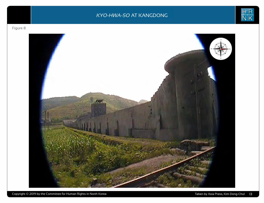
COPYRIGHT ©ALLSOURCE ANALYSIS, INC. 2016 3
H RN K
C H ’ O M A - B O N G R E S T R I C T E D A R E AH RN K
C A M P N O . 2 5
analysis also supports escapee and other reports indicating that Camp No. 25’s primary economic activity is focused on light industry and agriculture. Despite extensive satellite imagery coverage of the camp, AllSource is presently unable to confirm or deny escapee and open-source reports that the camp has a prisoner population of 5,000 people.
As with the analytical caution presented in previous reports (such as North Korea: Imagery Analysis Camp 16 and North Korea: Imagery Analysis of Camp 14 produced by HRNK and AllSource Analysis), it is important to reiterate that North Korean officials, especially those within the Korean People’s Army and the internal security organizations, clearly understand the importance of implementing camouflage, concealment, and deception (CCD) procedures to mask their operations and intentions.3 It would be reasonable to assume that they have done so here.
Location and Organization
Camp No. 25 is under the control of the
3 Bermudez Jr., Joseph S., Dinville, Andy and Eley, Mike. Imagery Analysis of Camp 16, (Washington, D.C.: The Committee for Human Rights in North Korea [HRNK], 2015) available at https://www.hrnk.org/uploads/pdfs/ASA_HRNK_Camp16_v8_full-res_FINAL_12_15_15.pdf and Bermudez Jr., Joseph S. Imagery Analysis: North Korea’s Camp No. 15, Update, (Washington, D.C.: HRNK, 2014) available at http://hrnk.org/uploads/pdfs/Camp%2025%20Update%20Good.pdf.
Prisons Bureau of the State Security Department (SSD), which is under the de facto control of the KWP OGD. Specifically, it is under the control of the SSD's North Hamgyong Provincial Bureau and is located approximately 7.5 km northwestof the port of Ch’ŏng-jin-si in Susŏng-dong, Ch’ŏngjin-si, Hamgyŏng-bukto.4 More specifically, it is
4 It is interesting to note that although the escapee descriptions of this facility’s mission matches that of other kwan-li-so, the physical characteristics ob-served in satellite imagery are more representative of the nation’s kyo-hwa-so, or long-term, felony penitentiaries and prison camps. David Hawk, The Hidden Gulag: Second Edition, Washington, D.C.: Committee for Human Rights in North Korea, 2012, www.hrnk.org/uploads/pdfs/HRNK_HiddenGu-lag2_Web_5-18.pdf. Another sources describes Camp No. 25 this way,
It is not structured as a village but is a fenced facility that looks like an ordinary prison camp [kyo-hwa-so] and is designed for collective living arrangements. The No. 25 [kwan-li-so] houses political prisoners only, while those who committed economic crimes are not allowed into the facility. Some inmates are released upon completion of their term as terms are fixed. Political criminals are detained alone with-out their families. …North Korean defector XXX [sic] testified, “Military personnel are sent off to the Susong kyo-hwa-so [No. 25 kwan-li-so] if their alleged crimes are of a political nature. The Susong kyo-hwa-so [No. 25 kwan-li-so] is for those serving terms of 10 years or longer, but they can return to society once they complete these terms.” It was also testified that the No. 25 kwan-li-so housed senior staff at the Provincial Party, the head of a local MPS office, and other high-ranking officials. North Korean defector XXX [sic] testified that the father of his
located on the south bank of the Sol-gol-ch’ŏn (i.e., Solgol stream) across from the village of Susŏng-dong, to which one foot and two road bridges connect it.
The date of establishment of Camp No. 25 is unclear. One report indicates that the camp was used as a prisoner-of-war camp housing South Korean soldiers at the end of the Korean War.5 This, how-ever, remains to be verified as it may not be referring to the present day camp but rather to an activity in this area. The area in which it is located has been involved in agricultural activities since at least the 1950s. Satellite imagery does indicate that Camp No. 25 was established prior to May 28, 1970, at which time it occupied an irregular shaped area that measured approximately 577 meters by 315 meters (631 yards by 344 yards) and encompassed 13.76 hectares (164,568
friend used to perform the duty of turning over Korean War POWs to South Korea, but he was arrested while attempting to cross the border at the river in Namyang, Onsung County, North Hamgyoung Province. He ended up at the No. 25 kwan-li-so in Chongjin.
Do Kyung-Ok et al., White Paper on Human Rights in North Korea 2015 (Seoul: Korea Institute for National Unification, 2015), p. 122, available at http://www.kinu.or.kr/eng/pub/pub_04_01.jsp.
5 “After the Korean War, it was used as a detention facility for South Korean POWs (Prisoners of War).” Do Kyung-Ok et al., White Paper on Human Rights in North Korea 2015 (Seoul: Korea Institute for National Unification, 2015), p. 122, available at http://www.kinu.or.kr/eng/pub/pub_04_01.jsp.
square yards) and was expanded slightly by January 27, 1976, when it measured approximately 700 meters by 315 meters (765 yards by 344 yards) and encom-passed 15.30 hectares (181,987 square yards) (Figure 1, Figure 2).6
High-resolution satellite imagery from January 18, 2003, through September 21, 2015, indicates that the camp has expanded during this period and that its primary economic activities are centered on agriculture and light industry (Figure 3 through Figure 15).
Several small villages and military facilities are located in the general area around the camp. The camp is connected to the regional electric power grid via overhead high voltage power transmis-sion cables that run from the camp to the substation approximately 1 kilometer to the southeast. It is connected to the national rail network via the station at Susŏng-dong, 800 meters to the east of the facility (Figure 16). The closest air facility to Camp No. 25 is the Korean People’s Air Force’s Sŭngam-ni Air Base, located 18 kilometers south-southwest. This is a training base, and based on its mission, organization, and location, almost certainly provides no support to Camp No. 25.
6 HRNK anticipates that we will be able to further refine the date of the camps establishment in future updates. Referenced imagery includes: KH-4B imagery dated May 28, 1970 and KH-9 (mapping camera) imagery dated January 27, 1976.
North Korea: Imagery Analysis of Camp No. 25 - Update 2
H RN KKYO-HWA-SO AT KANGDONG
Copyright © 2019 by the Committee for Human Rights in North Korea 13
Figure 8
Taken by Asia Press, Kim Dong-Chul

COPYRIGHT ©ALLSOURCE ANALYSIS, INC. 2016 3
H RN K
C H ’ O M A - B O N G R E S T R I C T E D A R E AH RN K
C A M P N O . 2 5
analysis also supports escapee and other reports indicating that Camp No. 25’s primary economic activity is focused on light industry and agriculture. Despite extensive satellite imagery coverage of the camp, AllSource is presently unable to confirm or deny escapee and open-source reports that the camp has a prisoner population of 5,000 people.
As with the analytical caution presented in previous reports (such as North Korea: Imagery Analysis Camp 16 and North Korea: Imagery Analysis of Camp 14 produced by HRNK and AllSource Analysis), it is important to reiterate that North Korean officials, especially those within the Korean People’s Army and the internal security organizations, clearly understand the importance of implementing camouflage, concealment, and deception (CCD) procedures to mask their operations and intentions.3 It would be reasonable to assume that they have done so here.
Location and Organization
Camp No. 25 is under the control of the
3 Bermudez Jr., Joseph S., Dinville, Andy and Eley, Mike. Imagery Analysis of Camp 16, (Washington, D.C.: The Committee for Human Rights in North Korea [HRNK], 2015) available at https://www.hrnk.org/uploads/pdfs/ASA_HRNK_Camp16_v8_full-res_FINAL_12_15_15.pdf and Bermudez Jr., Joseph S. Imagery Analysis: North Korea’s Camp No. 15, Update, (Washington, D.C.: HRNK, 2014) available at http://hrnk.org/uploads/pdfs/Camp%2025%20Update%20Good.pdf.
Prisons Bureau of the State Security Department (SSD), which is under the de facto control of the KWP OGD. Specifically, it is under the control of the SSD's North Hamgyong Provincial Bureau and is located approximately 7.5 km northwestof the port of Ch’ŏng-jin-si in Susŏng-dong, Ch’ŏngjin-si, Hamgyŏng-bukto.4 More specifically, it is
4 It is interesting to note that although the escapee descriptions of this facility’s mission matches that of other kwan-li-so, the physical characteristics ob-served in satellite imagery are more representative of the nation’s kyo-hwa-so, or long-term, felony penitentiaries and prison camps. David Hawk, The Hidden Gulag: Second Edition, Washington, D.C.: Committee for Human Rights in North Korea, 2012, www.hrnk.org/uploads/pdfs/HRNK_HiddenGu-lag2_Web_5-18.pdf. Another sources describes Camp No. 25 this way,
It is not structured as a village but is a fenced facility that looks like an ordinary prison camp [kyo-hwa-so] and is designed for collective living arrangements. The No. 25 [kwan-li-so] houses political prisoners only, while those who committed economic crimes are not allowed into the facility. Some inmates are released upon completion of their term as terms are fixed. Political criminals are detained alone with-out their families. …North Korean defector XXX [sic] testified, “Military personnel are sent off to the Susong kyo-hwa-so [No. 25 kwan-li-so] if their alleged crimes are of a political nature. The Susong kyo-hwa-so [No. 25 kwan-li-so] is for those serving terms of 10 years or longer, but they can return to society once they complete these terms.” It was also testified that the No. 25 kwan-li-so housed senior staff at the Provincial Party, the head of a local MPS office, and other high-ranking officials. North Korean defector XXX [sic] testified that the father of his
located on the south bank of the Sol-gol-ch’ŏn (i.e., Solgol stream) across from the village of Susŏng-dong, to which one foot and two road bridges connect it.
The date of establishment of Camp No. 25 is unclear. One report indicates that the camp was used as a prisoner-of-war camp housing South Korean soldiers at the end of the Korean War.5 This, how-ever, remains to be verified as it may not be referring to the present day camp but rather to an activity in this area. The area in which it is located has been involved in agricultural activities since at least the 1950s. Satellite imagery does indicate that Camp No. 25 was established prior to May 28, 1970, at which time it occupied an irregular shaped area that measured approximately 577 meters by 315 meters (631 yards by 344 yards) and encompassed 13.76 hectares (164,568
friend used to perform the duty of turning over Korean War POWs to South Korea, but he was arrested while attempting to cross the border at the river in Namyang, Onsung County, North Hamgyoung Province. He ended up at the No. 25 kwan-li-so in Chongjin.
Do Kyung-Ok et al., White Paper on Human Rights in North Korea 2015 (Seoul: Korea Institute for National Unification, 2015), p. 122, available at http://www.kinu.or.kr/eng/pub/pub_04_01.jsp.
5 “After the Korean War, it was used as a detention facility for South Korean POWs (Prisoners of War).” Do Kyung-Ok et al., White Paper on Human Rights in North Korea 2015 (Seoul: Korea Institute for National Unification, 2015), p. 122, available at http://www.kinu.or.kr/eng/pub/pub_04_01.jsp.
square yards) and was expanded slightly by January 27, 1976, when it measured approximately 700 meters by 315 meters (765 yards by 344 yards) and encom-passed 15.30 hectares (181,987 square yards) (Figure 1, Figure 2).6
High-resolution satellite imagery from January 18, 2003, through September 21, 2015, indicates that the camp has expanded during this period and that its primary economic activities are centered on agriculture and light industry (Figure 3 through Figure 15).
Several small villages and military facilities are located in the general area around the camp. The camp is connected to the regional electric power grid via overhead high voltage power transmis-sion cables that run from the camp to the substation approximately 1 kilometer to the southeast. It is connected to the national rail network via the station at Susŏng-dong, 800 meters to the east of the facility (Figure 16). The closest air facility to Camp No. 25 is the Korean People’s Air Force’s Sŭngam-ni Air Base, located 18 kilometers south-southwest. This is a training base, and based on its mission, organization, and location, almost certainly provides no support to Camp No. 25.
6 HRNK anticipates that we will be able to further refine the date of the camps establishment in future updates. Referenced imagery includes: KH-4B imagery dated May 28, 1970 and KH-9 (mapping camera) imagery dated January 27, 1976.
North Korea: Imagery Analysis of Camp No. 25 - Update 2
H RN KKYO-HWA-SO AT KANGDONG
Copyright © 2019 by the Committee for Human Rights in North Korea 14
Figure 9
Taken by Asia Press, Kim Dong-Chul
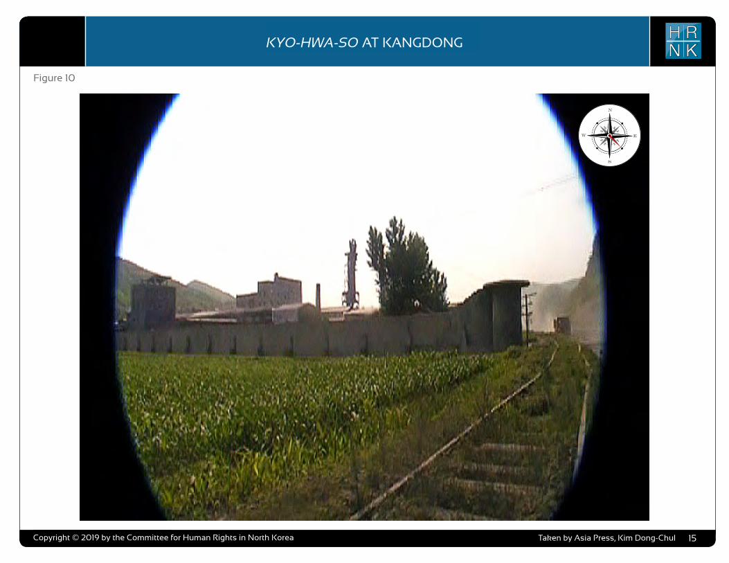
COPYRIGHT ©ALLSOURCE ANALYSIS, INC. 2016 3
H RN K
C H ’ O M A - B O N G R E S T R I C T E D A R E AH RN K
C A M P N O . 2 5
analysis also supports escapee and other reports indicating that Camp No. 25’s primary economic activity is focused on light industry and agriculture. Despite extensive satellite imagery coverage of the camp, AllSource is presently unable to confirm or deny escapee and open-source reports that the camp has a prisoner population of 5,000 people.
As with the analytical caution presented in previous reports (such as North Korea: Imagery Analysis Camp 16 and North Korea: Imagery Analysis of Camp 14 produced by HRNK and AllSource Analysis), it is important to reiterate that North Korean officials, especially those within the Korean People’s Army and the internal security organizations, clearly understand the importance of implementing camouflage, concealment, and deception (CCD) procedures to mask their operations and intentions.3 It would be reasonable to assume that they have done so here.
Location and Organization
Camp No. 25 is under the control of the
3 Bermudez Jr., Joseph S., Dinville, Andy and Eley, Mike. Imagery Analysis of Camp 16, (Washington, D.C.: The Committee for Human Rights in North Korea [HRNK], 2015) available at https://www.hrnk.org/uploads/pdfs/ASA_HRNK_Camp16_v8_full-res_FINAL_12_15_15.pdf and Bermudez Jr., Joseph S. Imagery Analysis: North Korea’s Camp No. 15, Update, (Washington, D.C.: HRNK, 2014) available at http://hrnk.org/uploads/pdfs/Camp%2025%20Update%20Good.pdf.
Prisons Bureau of the State Security Department (SSD), which is under the de facto control of the KWP OGD. Specifically, it is under the control of the SSD's North Hamgyong Provincial Bureau and is located approximately 7.5 km northwestof the port of Ch’ŏng-jin-si in Susŏng-dong, Ch’ŏngjin-si, Hamgyŏng-bukto.4 More specifically, it is
4 It is interesting to note that although the escapee descriptions of this facility’s mission matches that of other kwan-li-so, the physical characteristics ob-served in satellite imagery are more representative of the nation’s kyo-hwa-so, or long-term, felony penitentiaries and prison camps. David Hawk, The Hidden Gulag: Second Edition, Washington, D.C.: Committee for Human Rights in North Korea, 2012, www.hrnk.org/uploads/pdfs/HRNK_HiddenGu-lag2_Web_5-18.pdf. Another sources describes Camp No. 25 this way,
It is not structured as a village but is a fenced facility that looks like an ordinary prison camp [kyo-hwa-so] and is designed for collective living arrangements. The No. 25 [kwan-li-so] houses political prisoners only, while those who committed economic crimes are not allowed into the facility. Some inmates are released upon completion of their term as terms are fixed. Political criminals are detained alone with-out their families. …North Korean defector XXX [sic] testified, “Military personnel are sent off to the Susong kyo-hwa-so [No. 25 kwan-li-so] if their alleged crimes are of a political nature. The Susong kyo-hwa-so [No. 25 kwan-li-so] is for those serving terms of 10 years or longer, but they can return to society once they complete these terms.” It was also testified that the No. 25 kwan-li-so housed senior staff at the Provincial Party, the head of a local MPS office, and other high-ranking officials. North Korean defector XXX [sic] testified that the father of his
located on the south bank of the Sol-gol-ch’ŏn (i.e., Solgol stream) across from the village of Susŏng-dong, to which one foot and two road bridges connect it.
The date of establishment of Camp No. 25 is unclear. One report indicates that the camp was used as a prisoner-of-war camp housing South Korean soldiers at the end of the Korean War.5 This, how-ever, remains to be verified as it may not be referring to the present day camp but rather to an activity in this area. The area in which it is located has been involved in agricultural activities since at least the 1950s. Satellite imagery does indicate that Camp No. 25 was established prior to May 28, 1970, at which time it occupied an irregular shaped area that measured approximately 577 meters by 315 meters (631 yards by 344 yards) and encompassed 13.76 hectares (164,568
friend used to perform the duty of turning over Korean War POWs to South Korea, but he was arrested while attempting to cross the border at the river in Namyang, Onsung County, North Hamgyoung Province. He ended up at the No. 25 kwan-li-so in Chongjin.
Do Kyung-Ok et al., White Paper on Human Rights in North Korea 2015 (Seoul: Korea Institute for National Unification, 2015), p. 122, available at http://www.kinu.or.kr/eng/pub/pub_04_01.jsp.
5 “After the Korean War, it was used as a detention facility for South Korean POWs (Prisoners of War).” Do Kyung-Ok et al., White Paper on Human Rights in North Korea 2015 (Seoul: Korea Institute for National Unification, 2015), p. 122, available at http://www.kinu.or.kr/eng/pub/pub_04_01.jsp.
square yards) and was expanded slightly by January 27, 1976, when it measured approximately 700 meters by 315 meters (765 yards by 344 yards) and encom-passed 15.30 hectares (181,987 square yards) (Figure 1, Figure 2).6
High-resolution satellite imagery from January 18, 2003, through September 21, 2015, indicates that the camp has expanded during this period and that its primary economic activities are centered on agriculture and light industry (Figure 3 through Figure 15).
Several small villages and military facilities are located in the general area around the camp. The camp is connected to the regional electric power grid via overhead high voltage power transmis-sion cables that run from the camp to the substation approximately 1 kilometer to the southeast. It is connected to the national rail network via the station at Susŏng-dong, 800 meters to the east of the facility (Figure 16). The closest air facility to Camp No. 25 is the Korean People’s Air Force’s Sŭngam-ni Air Base, located 18 kilometers south-southwest. This is a training base, and based on its mission, organization, and location, almost certainly provides no support to Camp No. 25.
6 HRNK anticipates that we will be able to further refine the date of the camps establishment in future updates. Referenced imagery includes: KH-4B imagery dated May 28, 1970 and KH-9 (mapping camera) imagery dated January 27, 1976.
North Korea: Imagery Analysis of Camp No. 25 - Update 2
H RN KKYO-HWA-SO AT KANGDONG
Copyright © 2019 by the Committee for Human Rights in North Korea 15
Figure 10
Taken by Asia Press, Kim Dong-Chul

COPYRIGHT ©ALLSOURCE ANALYSIS, INC. 2016 3
H RN K
C H ’ O M A - B O N G R E S T R I C T E D A R E AH RN K
C A M P N O . 2 5
analysis also supports escapee and other reports indicating that Camp No. 25’s primary economic activity is focused on light industry and agriculture. Despite extensive satellite imagery coverage of the camp, AllSource is presently unable to confirm or deny escapee and open-source reports that the camp has a prisoner population of 5,000 people.
As with the analytical caution presented in previous reports (such as North Korea: Imagery Analysis Camp 16 and North Korea: Imagery Analysis of Camp 14 produced by HRNK and AllSource Analysis), it is important to reiterate that North Korean officials, especially those within the Korean People’s Army and the internal security organizations, clearly understand the importance of implementing camouflage, concealment, and deception (CCD) procedures to mask their operations and intentions.3 It would be reasonable to assume that they have done so here.
Location and Organization
Camp No. 25 is under the control of the
3 Bermudez Jr., Joseph S., Dinville, Andy and Eley, Mike. Imagery Analysis of Camp 16, (Washington, D.C.: The Committee for Human Rights in North Korea [HRNK], 2015) available at https://www.hrnk.org/uploads/pdfs/ASA_HRNK_Camp16_v8_full-res_FINAL_12_15_15.pdf and Bermudez Jr., Joseph S. Imagery Analysis: North Korea’s Camp No. 15, Update, (Washington, D.C.: HRNK, 2014) available at http://hrnk.org/uploads/pdfs/Camp%2025%20Update%20Good.pdf.
Prisons Bureau of the State Security Department (SSD), which is under the de facto control of the KWP OGD. Specifically, it is under the control of the SSD's North Hamgyong Provincial Bureau and is located approximately 7.5 km northwestof the port of Ch’ŏng-jin-si in Susŏng-dong, Ch’ŏngjin-si, Hamgyŏng-bukto.4 More specifically, it is
4 It is interesting to note that although the escapee descriptions of this facility’s mission matches that of other kwan-li-so, the physical characteristics ob-served in satellite imagery are more representative of the nation’s kyo-hwa-so, or long-term, felony penitentiaries and prison camps. David Hawk, The Hidden Gulag: Second Edition, Washington, D.C.: Committee for Human Rights in North Korea, 2012, www.hrnk.org/uploads/pdfs/HRNK_HiddenGu-lag2_Web_5-18.pdf. Another sources describes Camp No. 25 this way,
It is not structured as a village but is a fenced facility that looks like an ordinary prison camp [kyo-hwa-so] and is designed for collective living arrangements. The No. 25 [kwan-li-so] houses political prisoners only, while those who committed economic crimes are not allowed into the facility. Some inmates are released upon completion of their term as terms are fixed. Political criminals are detained alone with-out their families. …North Korean defector XXX [sic] testified, “Military personnel are sent off to the Susong kyo-hwa-so [No. 25 kwan-li-so] if their alleged crimes are of a political nature. The Susong kyo-hwa-so [No. 25 kwan-li-so] is for those serving terms of 10 years or longer, but they can return to society once they complete these terms.” It was also testified that the No. 25 kwan-li-so housed senior staff at the Provincial Party, the head of a local MPS office, and other high-ranking officials. North Korean defector XXX [sic] testified that the father of his
located on the south bank of the Sol-gol-ch’ŏn (i.e., Solgol stream) across from the village of Susŏng-dong, to which one foot and two road bridges connect it.
The date of establishment of Camp No. 25 is unclear. One report indicates that the camp was used as a prisoner-of-war camp housing South Korean soldiers at the end of the Korean War.5 This, how-ever, remains to be verified as it may not be referring to the present day camp but rather to an activity in this area. The area in which it is located has been involved in agricultural activities since at least the 1950s. Satellite imagery does indicate that Camp No. 25 was established prior to May 28, 1970, at which time it occupied an irregular shaped area that measured approximately 577 meters by 315 meters (631 yards by 344 yards) and encompassed 13.76 hectares (164,568
friend used to perform the duty of turning over Korean War POWs to South Korea, but he was arrested while attempting to cross the border at the river in Namyang, Onsung County, North Hamgyoung Province. He ended up at the No. 25 kwan-li-so in Chongjin.
Do Kyung-Ok et al., White Paper on Human Rights in North Korea 2015 (Seoul: Korea Institute for National Unification, 2015), p. 122, available at http://www.kinu.or.kr/eng/pub/pub_04_01.jsp.
5 “After the Korean War, it was used as a detention facility for South Korean POWs (Prisoners of War).” Do Kyung-Ok et al., White Paper on Human Rights in North Korea 2015 (Seoul: Korea Institute for National Unification, 2015), p. 122, available at http://www.kinu.or.kr/eng/pub/pub_04_01.jsp.
square yards) and was expanded slightly by January 27, 1976, when it measured approximately 700 meters by 315 meters (765 yards by 344 yards) and encom-passed 15.30 hectares (181,987 square yards) (Figure 1, Figure 2).6
High-resolution satellite imagery from January 18, 2003, through September 21, 2015, indicates that the camp has expanded during this period and that its primary economic activities are centered on agriculture and light industry (Figure 3 through Figure 15).
Several small villages and military facilities are located in the general area around the camp. The camp is connected to the regional electric power grid via overhead high voltage power transmis-sion cables that run from the camp to the substation approximately 1 kilometer to the southeast. It is connected to the national rail network via the station at Susŏng-dong, 800 meters to the east of the facility (Figure 16). The closest air facility to Camp No. 25 is the Korean People’s Air Force’s Sŭngam-ni Air Base, located 18 kilometers south-southwest. This is a training base, and based on its mission, organization, and location, almost certainly provides no support to Camp No. 25.
6 HRNK anticipates that we will be able to further refine the date of the camps establishment in future updates. Referenced imagery includes: KH-4B imagery dated May 28, 1970 and KH-9 (mapping camera) imagery dated January 27, 1976.
North Korea: Imagery Analysis of Camp No. 25 - Update 2
H RN KKYO-HWA-SO AT KANGDONG
Copyright © 2019 by the Committee for Human Rights in North Korea 16
Figure 11
Taken by Asia Press, Kim Dong-Chul

COPYRIGHT ©ALLSOURCE ANALYSIS, INC. 2016 3
H RN K
C H ’ O M A - B O N G R E S T R I C T E D A R E AH RN K
C A M P N O . 2 5
analysis also supports escapee and other reports indicating that Camp No. 25’s primary economic activity is focused on light industry and agriculture. Despite extensive satellite imagery coverage of the camp, AllSource is presently unable to confirm or deny escapee and open-source reports that the camp has a prisoner population of 5,000 people.
As with the analytical caution presented in previous reports (such as North Korea: Imagery Analysis Camp 16 and North Korea: Imagery Analysis of Camp 14 produced by HRNK and AllSource Analysis), it is important to reiterate that North Korean officials, especially those within the Korean People’s Army and the internal security organizations, clearly understand the importance of implementing camouflage, concealment, and deception (CCD) procedures to mask their operations and intentions.3 It would be reasonable to assume that they have done so here.
Location and Organization
Camp No. 25 is under the control of the
3 Bermudez Jr., Joseph S., Dinville, Andy and Eley, Mike. Imagery Analysis of Camp 16, (Washington, D.C.: The Committee for Human Rights in North Korea [HRNK], 2015) available at https://www.hrnk.org/uploads/pdfs/ASA_HRNK_Camp16_v8_full-res_FINAL_12_15_15.pdf and Bermudez Jr., Joseph S. Imagery Analysis: North Korea’s Camp No. 15, Update, (Washington, D.C.: HRNK, 2014) available at http://hrnk.org/uploads/pdfs/Camp%2025%20Update%20Good.pdf.
Prisons Bureau of the State Security Department (SSD), which is under the de facto control of the KWP OGD. Specifically, it is under the control of the SSD's North Hamgyong Provincial Bureau and is located approximately 7.5 km northwestof the port of Ch’ŏng-jin-si in Susŏng-dong, Ch’ŏngjin-si, Hamgyŏng-bukto.4 More specifically, it is
4 It is interesting to note that although the escapee descriptions of this facility’s mission matches that of other kwan-li-so, the physical characteristics ob-served in satellite imagery are more representative of the nation’s kyo-hwa-so, or long-term, felony penitentiaries and prison camps. David Hawk, The Hidden Gulag: Second Edition, Washington, D.C.: Committee for Human Rights in North Korea, 2012, www.hrnk.org/uploads/pdfs/HRNK_HiddenGu-lag2_Web_5-18.pdf. Another sources describes Camp No. 25 this way,
It is not structured as a village but is a fenced facility that looks like an ordinary prison camp [kyo-hwa-so] and is designed for collective living arrangements. The No. 25 [kwan-li-so] houses political prisoners only, while those who committed economic crimes are not allowed into the facility. Some inmates are released upon completion of their term as terms are fixed. Political criminals are detained alone with-out their families. …North Korean defector XXX [sic] testified, “Military personnel are sent off to the Susong kyo-hwa-so [No. 25 kwan-li-so] if their alleged crimes are of a political nature. The Susong kyo-hwa-so [No. 25 kwan-li-so] is for those serving terms of 10 years or longer, but they can return to society once they complete these terms.” It was also testified that the No. 25 kwan-li-so housed senior staff at the Provincial Party, the head of a local MPS office, and other high-ranking officials. North Korean defector XXX [sic] testified that the father of his
located on the south bank of the Sol-gol-ch’ŏn (i.e., Solgol stream) across from the village of Susŏng-dong, to which one foot and two road bridges connect it.
The date of establishment of Camp No. 25 is unclear. One report indicates that the camp was used as a prisoner-of-war camp housing South Korean soldiers at the end of the Korean War.5 This, how-ever, remains to be verified as it may not be referring to the present day camp but rather to an activity in this area. The area in which it is located has been involved in agricultural activities since at least the 1950s. Satellite imagery does indicate that Camp No. 25 was established prior to May 28, 1970, at which time it occupied an irregular shaped area that measured approximately 577 meters by 315 meters (631 yards by 344 yards) and encompassed 13.76 hectares (164,568
friend used to perform the duty of turning over Korean War POWs to South Korea, but he was arrested while attempting to cross the border at the river in Namyang, Onsung County, North Hamgyoung Province. He ended up at the No. 25 kwan-li-so in Chongjin.
Do Kyung-Ok et al., White Paper on Human Rights in North Korea 2015 (Seoul: Korea Institute for National Unification, 2015), p. 122, available at http://www.kinu.or.kr/eng/pub/pub_04_01.jsp.
5 “After the Korean War, it was used as a detention facility for South Korean POWs (Prisoners of War).” Do Kyung-Ok et al., White Paper on Human Rights in North Korea 2015 (Seoul: Korea Institute for National Unification, 2015), p. 122, available at http://www.kinu.or.kr/eng/pub/pub_04_01.jsp.
square yards) and was expanded slightly by January 27, 1976, when it measured approximately 700 meters by 315 meters (765 yards by 344 yards) and encom-passed 15.30 hectares (181,987 square yards) (Figure 1, Figure 2).6
High-resolution satellite imagery from January 18, 2003, through September 21, 2015, indicates that the camp has expanded during this period and that its primary economic activities are centered on agriculture and light industry (Figure 3 through Figure 15).
Several small villages and military facilities are located in the general area around the camp. The camp is connected to the regional electric power grid via overhead high voltage power transmis-sion cables that run from the camp to the substation approximately 1 kilometer to the southeast. It is connected to the national rail network via the station at Susŏng-dong, 800 meters to the east of the facility (Figure 16). The closest air facility to Camp No. 25 is the Korean People’s Air Force’s Sŭngam-ni Air Base, located 18 kilometers south-southwest. This is a training base, and based on its mission, organization, and location, almost certainly provides no support to Camp No. 25.
6 HRNK anticipates that we will be able to further refine the date of the camps establishment in future updates. Referenced imagery includes: KH-4B imagery dated May 28, 1970 and KH-9 (mapping camera) imagery dated January 27, 1976.
North Korea: Imagery Analysis of Camp No. 25 - Update 2
H RN KKYO-HWA-SO AT KANGDONG
Copyright © 2019 by the Committee for Human Rights in North Korea 17
Figure 12
Taken by Asia Press, Kim Dong-Chul

COPYRIGHT ©ALLSOURCE ANALYSIS, INC. 2016 3
H RN K
C H ’ O M A - B O N G R E S T R I C T E D A R E AH RN K
C A M P N O . 2 5
analysis also supports escapee and other reports indicating that Camp No. 25’s primary economic activity is focused on light industry and agriculture. Despite extensive satellite imagery coverage of the camp, AllSource is presently unable to confirm or deny escapee and open-source reports that the camp has a prisoner population of 5,000 people.
As with the analytical caution presented in previous reports (such as North Korea: Imagery Analysis Camp 16 and North Korea: Imagery Analysis of Camp 14 produced by HRNK and AllSource Analysis), it is important to reiterate that North Korean officials, especially those within the Korean People’s Army and the internal security organizations, clearly understand the importance of implementing camouflage, concealment, and deception (CCD) procedures to mask their operations and intentions.3 It would be reasonable to assume that they have done so here.
Location and Organization
Camp No. 25 is under the control of the
3 Bermudez Jr., Joseph S., Dinville, Andy and Eley, Mike. Imagery Analysis of Camp 16, (Washington, D.C.: The Committee for Human Rights in North Korea [HRNK], 2015) available at https://www.hrnk.org/uploads/pdfs/ASA_HRNK_Camp16_v8_full-res_FINAL_12_15_15.pdf and Bermudez Jr., Joseph S. Imagery Analysis: North Korea’s Camp No. 15, Update, (Washington, D.C.: HRNK, 2014) available at http://hrnk.org/uploads/pdfs/Camp%2025%20Update%20Good.pdf.
Prisons Bureau of the State Security Department (SSD), which is under the de facto control of the KWP OGD. Specifically, it is under the control of the SSD's North Hamgyong Provincial Bureau and is located approximately 7.5 km northwestof the port of Ch’ŏng-jin-si in Susŏng-dong, Ch’ŏngjin-si, Hamgyŏng-bukto.4 More specifically, it is
4 It is interesting to note that although the escapee descriptions of this facility’s mission matches that of other kwan-li-so, the physical characteristics ob-served in satellite imagery are more representative of the nation’s kyo-hwa-so, or long-term, felony penitentiaries and prison camps. David Hawk, The Hidden Gulag: Second Edition, Washington, D.C.: Committee for Human Rights in North Korea, 2012, www.hrnk.org/uploads/pdfs/HRNK_HiddenGu-lag2_Web_5-18.pdf. Another sources describes Camp No. 25 this way,
It is not structured as a village but is a fenced facility that looks like an ordinary prison camp [kyo-hwa-so] and is designed for collective living arrangements. The No. 25 [kwan-li-so] houses political prisoners only, while those who committed economic crimes are not allowed into the facility. Some inmates are released upon completion of their term as terms are fixed. Political criminals are detained alone with-out their families. …North Korean defector XXX [sic] testified, “Military personnel are sent off to the Susong kyo-hwa-so [No. 25 kwan-li-so] if their alleged crimes are of a political nature. The Susong kyo-hwa-so [No. 25 kwan-li-so] is for those serving terms of 10 years or longer, but they can return to society once they complete these terms.” It was also testified that the No. 25 kwan-li-so housed senior staff at the Provincial Party, the head of a local MPS office, and other high-ranking officials. North Korean defector XXX [sic] testified that the father of his
located on the south bank of the Sol-gol-ch’ŏn (i.e., Solgol stream) across from the village of Susŏng-dong, to which one foot and two road bridges connect it.
The date of establishment of Camp No. 25 is unclear. One report indicates that the camp was used as a prisoner-of-war camp housing South Korean soldiers at the end of the Korean War.5 This, how-ever, remains to be verified as it may not be referring to the present day camp but rather to an activity in this area. The area in which it is located has been involved in agricultural activities since at least the 1950s. Satellite imagery does indicate that Camp No. 25 was established prior to May 28, 1970, at which time it occupied an irregular shaped area that measured approximately 577 meters by 315 meters (631 yards by 344 yards) and encompassed 13.76 hectares (164,568
friend used to perform the duty of turning over Korean War POWs to South Korea, but he was arrested while attempting to cross the border at the river in Namyang, Onsung County, North Hamgyoung Province. He ended up at the No. 25 kwan-li-so in Chongjin.
Do Kyung-Ok et al., White Paper on Human Rights in North Korea 2015 (Seoul: Korea Institute for National Unification, 2015), p. 122, available at http://www.kinu.or.kr/eng/pub/pub_04_01.jsp.
5 “After the Korean War, it was used as a detention facility for South Korean POWs (Prisoners of War).” Do Kyung-Ok et al., White Paper on Human Rights in North Korea 2015 (Seoul: Korea Institute for National Unification, 2015), p. 122, available at http://www.kinu.or.kr/eng/pub/pub_04_01.jsp.
square yards) and was expanded slightly by January 27, 1976, when it measured approximately 700 meters by 315 meters (765 yards by 344 yards) and encom-passed 15.30 hectares (181,987 square yards) (Figure 1, Figure 2).6
High-resolution satellite imagery from January 18, 2003, through September 21, 2015, indicates that the camp has expanded during this period and that its primary economic activities are centered on agriculture and light industry (Figure 3 through Figure 15).
Several small villages and military facilities are located in the general area around the camp. The camp is connected to the regional electric power grid via overhead high voltage power transmis-sion cables that run from the camp to the substation approximately 1 kilometer to the southeast. It is connected to the national rail network via the station at Susŏng-dong, 800 meters to the east of the facility (Figure 16). The closest air facility to Camp No. 25 is the Korean People’s Air Force’s Sŭngam-ni Air Base, located 18 kilometers south-southwest. This is a training base, and based on its mission, organization, and location, almost certainly provides no support to Camp No. 25.
6 HRNK anticipates that we will be able to further refine the date of the camps establishment in future updates. Referenced imagery includes: KH-4B imagery dated May 28, 1970 and KH-9 (mapping camera) imagery dated January 27, 1976.
North Korea: Imagery Analysis of Camp No. 25 - Update 2
H RN KKYO-HWA-SO AT KANGDONG
Copyright © 2019 by the Committee for Human Rights in North Korea 18
Figure 13
Taken by Asia Press, Kim Dong-Chul

COPYRIGHT ©ALLSOURCE ANALYSIS, INC. 2016 3
H RN K
C H ’ O M A - B O N G R E S T R I C T E D A R E AH RN K
C A M P N O . 2 5
analysis also supports escapee and other reports indicating that Camp No. 25’s primary economic activity is focused on light industry and agriculture. Despite extensive satellite imagery coverage of the camp, AllSource is presently unable to confirm or deny escapee and open-source reports that the camp has a prisoner population of 5,000 people.
As with the analytical caution presented in previous reports (such as North Korea: Imagery Analysis Camp 16 and North Korea: Imagery Analysis of Camp 14 produced by HRNK and AllSource Analysis), it is important to reiterate that North Korean officials, especially those within the Korean People’s Army and the internal security organizations, clearly understand the importance of implementing camouflage, concealment, and deception (CCD) procedures to mask their operations and intentions.3 It would be reasonable to assume that they have done so here.
Location and Organization
Camp No. 25 is under the control of the
3 Bermudez Jr., Joseph S., Dinville, Andy and Eley, Mike. Imagery Analysis of Camp 16, (Washington, D.C.: The Committee for Human Rights in North Korea [HRNK], 2015) available at https://www.hrnk.org/uploads/pdfs/ASA_HRNK_Camp16_v8_full-res_FINAL_12_15_15.pdf and Bermudez Jr., Joseph S. Imagery Analysis: North Korea’s Camp No. 15, Update, (Washington, D.C.: HRNK, 2014) available at http://hrnk.org/uploads/pdfs/Camp%2025%20Update%20Good.pdf.
Prisons Bureau of the State Security Department (SSD), which is under the de facto control of the KWP OGD. Specifically, it is under the control of the SSD's North Hamgyong Provincial Bureau and is located approximately 7.5 km northwestof the port of Ch’ŏng-jin-si in Susŏng-dong, Ch’ŏngjin-si, Hamgyŏng-bukto.4 More specifically, it is
4 It is interesting to note that although the escapee descriptions of this facility’s mission matches that of other kwan-li-so, the physical characteristics ob-served in satellite imagery are more representative of the nation’s kyo-hwa-so, or long-term, felony penitentiaries and prison camps. David Hawk, The Hidden Gulag: Second Edition, Washington, D.C.: Committee for Human Rights in North Korea, 2012, www.hrnk.org/uploads/pdfs/HRNK_HiddenGu-lag2_Web_5-18.pdf. Another sources describes Camp No. 25 this way,
It is not structured as a village but is a fenced facility that looks like an ordinary prison camp [kyo-hwa-so] and is designed for collective living arrangements. The No. 25 [kwan-li-so] houses political prisoners only, while those who committed economic crimes are not allowed into the facility. Some inmates are released upon completion of their term as terms are fixed. Political criminals are detained alone with-out their families. …North Korean defector XXX [sic] testified, “Military personnel are sent off to the Susong kyo-hwa-so [No. 25 kwan-li-so] if their alleged crimes are of a political nature. The Susong kyo-hwa-so [No. 25 kwan-li-so] is for those serving terms of 10 years or longer, but they can return to society once they complete these terms.” It was also testified that the No. 25 kwan-li-so housed senior staff at the Provincial Party, the head of a local MPS office, and other high-ranking officials. North Korean defector XXX [sic] testified that the father of his
located on the south bank of the Sol-gol-ch’ŏn (i.e., Solgol stream) across from the village of Susŏng-dong, to which one foot and two road bridges connect it.
The date of establishment of Camp No. 25 is unclear. One report indicates that the camp was used as a prisoner-of-war camp housing South Korean soldiers at the end of the Korean War.5 This, how-ever, remains to be verified as it may not be referring to the present day camp but rather to an activity in this area. The area in which it is located has been involved in agricultural activities since at least the 1950s. Satellite imagery does indicate that Camp No. 25 was established prior to May 28, 1970, at which time it occupied an irregular shaped area that measured approximately 577 meters by 315 meters (631 yards by 344 yards) and encompassed 13.76 hectares (164,568
friend used to perform the duty of turning over Korean War POWs to South Korea, but he was arrested while attempting to cross the border at the river in Namyang, Onsung County, North Hamgyoung Province. He ended up at the No. 25 kwan-li-so in Chongjin.
Do Kyung-Ok et al., White Paper on Human Rights in North Korea 2015 (Seoul: Korea Institute for National Unification, 2015), p. 122, available at http://www.kinu.or.kr/eng/pub/pub_04_01.jsp.
5 “After the Korean War, it was used as a detention facility for South Korean POWs (Prisoners of War).” Do Kyung-Ok et al., White Paper on Human Rights in North Korea 2015 (Seoul: Korea Institute for National Unification, 2015), p. 122, available at http://www.kinu.or.kr/eng/pub/pub_04_01.jsp.
square yards) and was expanded slightly by January 27, 1976, when it measured approximately 700 meters by 315 meters (765 yards by 344 yards) and encom-passed 15.30 hectares (181,987 square yards) (Figure 1, Figure 2).6
High-resolution satellite imagery from January 18, 2003, through September 21, 2015, indicates that the camp has expanded during this period and that its primary economic activities are centered on agriculture and light industry (Figure 3 through Figure 15).
Several small villages and military facilities are located in the general area around the camp. The camp is connected to the regional electric power grid via overhead high voltage power transmis-sion cables that run from the camp to the substation approximately 1 kilometer to the southeast. It is connected to the national rail network via the station at Susŏng-dong, 800 meters to the east of the facility (Figure 16). The closest air facility to Camp No. 25 is the Korean People’s Air Force’s Sŭngam-ni Air Base, located 18 kilometers south-southwest. This is a training base, and based on its mission, organization, and location, almost certainly provides no support to Camp No. 25.
6 HRNK anticipates that we will be able to further refine the date of the camps establishment in future updates. Referenced imagery includes: KH-4B imagery dated May 28, 1970 and KH-9 (mapping camera) imagery dated January 27, 1976.
North Korea: Imagery Analysis of Camp No. 25 - Update 2
H RN KKYO-HWA-SO AT KANGDONG
Copyright © 2019 by the Committee for Human Rights in North Korea 19
Figure 14
Taken by Asia Press, Kim Dong-Chul

COPYRIGHT ©ALLSOURCE ANALYSIS, INC. 2016 3
H RN K
C H ’ O M A - B O N G R E S T R I C T E D A R E AH RN K
C A M P N O . 2 5
analysis also supports escapee and other reports indicating that Camp No. 25’s primary economic activity is focused on light industry and agriculture. Despite extensive satellite imagery coverage of the camp, AllSource is presently unable to confirm or deny escapee and open-source reports that the camp has a prisoner population of 5,000 people.
As with the analytical caution presented in previous reports (such as North Korea: Imagery Analysis Camp 16 and North Korea: Imagery Analysis of Camp 14 produced by HRNK and AllSource Analysis), it is important to reiterate that North Korean officials, especially those within the Korean People’s Army and the internal security organizations, clearly understand the importance of implementing camouflage, concealment, and deception (CCD) procedures to mask their operations and intentions.3 It would be reasonable to assume that they have done so here.
Location and Organization
Camp No. 25 is under the control of the
3 Bermudez Jr., Joseph S., Dinville, Andy and Eley, Mike. Imagery Analysis of Camp 16, (Washington, D.C.: The Committee for Human Rights in North Korea [HRNK], 2015) available at https://www.hrnk.org/uploads/pdfs/ASA_HRNK_Camp16_v8_full-res_FINAL_12_15_15.pdf and Bermudez Jr., Joseph S. Imagery Analysis: North Korea’s Camp No. 15, Update, (Washington, D.C.: HRNK, 2014) available at http://hrnk.org/uploads/pdfs/Camp%2025%20Update%20Good.pdf.
Prisons Bureau of the State Security Department (SSD), which is under the de facto control of the KWP OGD. Specifically, it is under the control of the SSD's North Hamgyong Provincial Bureau and is located approximately 7.5 km northwestof the port of Ch’ŏng-jin-si in Susŏng-dong, Ch’ŏngjin-si, Hamgyŏng-bukto.4 More specifically, it is
4 It is interesting to note that although the escapee descriptions of this facility’s mission matches that of other kwan-li-so, the physical characteristics ob-served in satellite imagery are more representative of the nation’s kyo-hwa-so, or long-term, felony penitentiaries and prison camps. David Hawk, The Hidden Gulag: Second Edition, Washington, D.C.: Committee for Human Rights in North Korea, 2012, www.hrnk.org/uploads/pdfs/HRNK_HiddenGu-lag2_Web_5-18.pdf. Another sources describes Camp No. 25 this way,
It is not structured as a village but is a fenced facility that looks like an ordinary prison camp [kyo-hwa-so] and is designed for collective living arrangements. The No. 25 [kwan-li-so] houses political prisoners only, while those who committed economic crimes are not allowed into the facility. Some inmates are released upon completion of their term as terms are fixed. Political criminals are detained alone with-out their families. …North Korean defector XXX [sic] testified, “Military personnel are sent off to the Susong kyo-hwa-so [No. 25 kwan-li-so] if their alleged crimes are of a political nature. The Susong kyo-hwa-so [No. 25 kwan-li-so] is for those serving terms of 10 years or longer, but they can return to society once they complete these terms.” It was also testified that the No. 25 kwan-li-so housed senior staff at the Provincial Party, the head of a local MPS office, and other high-ranking officials. North Korean defector XXX [sic] testified that the father of his
located on the south bank of the Sol-gol-ch’ŏn (i.e., Solgol stream) across from the village of Susŏng-dong, to which one foot and two road bridges connect it.
The date of establishment of Camp No. 25 is unclear. One report indicates that the camp was used as a prisoner-of-war camp housing South Korean soldiers at the end of the Korean War.5 This, how-ever, remains to be verified as it may not be referring to the present day camp but rather to an activity in this area. The area in which it is located has been involved in agricultural activities since at least the 1950s. Satellite imagery does indicate that Camp No. 25 was established prior to May 28, 1970, at which time it occupied an irregular shaped area that measured approximately 577 meters by 315 meters (631 yards by 344 yards) and encompassed 13.76 hectares (164,568
friend used to perform the duty of turning over Korean War POWs to South Korea, but he was arrested while attempting to cross the border at the river in Namyang, Onsung County, North Hamgyoung Province. He ended up at the No. 25 kwan-li-so in Chongjin.
Do Kyung-Ok et al., White Paper on Human Rights in North Korea 2015 (Seoul: Korea Institute for National Unification, 2015), p. 122, available at http://www.kinu.or.kr/eng/pub/pub_04_01.jsp.
5 “After the Korean War, it was used as a detention facility for South Korean POWs (Prisoners of War).” Do Kyung-Ok et al., White Paper on Human Rights in North Korea 2015 (Seoul: Korea Institute for National Unification, 2015), p. 122, available at http://www.kinu.or.kr/eng/pub/pub_04_01.jsp.
square yards) and was expanded slightly by January 27, 1976, when it measured approximately 700 meters by 315 meters (765 yards by 344 yards) and encom-passed 15.30 hectares (181,987 square yards) (Figure 1, Figure 2).6
High-resolution satellite imagery from January 18, 2003, through September 21, 2015, indicates that the camp has expanded during this period and that its primary economic activities are centered on agriculture and light industry (Figure 3 through Figure 15).
Several small villages and military facilities are located in the general area around the camp. The camp is connected to the regional electric power grid via overhead high voltage power transmis-sion cables that run from the camp to the substation approximately 1 kilometer to the southeast. It is connected to the national rail network via the station at Susŏng-dong, 800 meters to the east of the facility (Figure 16). The closest air facility to Camp No. 25 is the Korean People’s Air Force’s Sŭngam-ni Air Base, located 18 kilometers south-southwest. This is a training base, and based on its mission, organization, and location, almost certainly provides no support to Camp No. 25.
6 HRNK anticipates that we will be able to further refine the date of the camps establishment in future updates. Referenced imagery includes: KH-4B imagery dated May 28, 1970 and KH-9 (mapping camera) imagery dated January 27, 1976.
North Korea: Imagery Analysis of Camp No. 25 - Update 2
H RN KKYO-HWA-SO AT KANGDONG
Copyright © 2019 by the Committee for Human Rights in North Korea 20
Imagery from September 23, 2011 shows no major changes within the prison. Some infrastructure developments, however, were observed outside and adjacent to the northeast corner of the prison. Here, a compound encompass-ing approximately 4,220 square meters with a partial low wall and a small building were erect-ed between 2009 and 2011. The positioning of this compound and guard position 50-meters north-east suggests that this compound was associated with the prison. On the opposite side of the road from the prison the rock quarry
administration and storage area is being expanded suggesting an increase in production.
By April 7, 2013, the small com-pound outside the northeast corner of the prison had been completely enclosed by a wall that was connected to the main prison wall and several additional support buildings were erect-ed. The general appearance and layout of the compound indicates that it was being used for grain threshing—likely in support of the prison due to its location in regard to the prison’s wall and
the guard position 50-meters to the north. No significant changes were observed elsewhere within the prison.
Imagery from October 16, 2014 shows no major changes within the main prison compound. However, within the headquarters, administration, and barracks area the cultural/education hall was rebuilt and three buildings were erected in the support and housing area. More significantly, the small compound outside the northeast corner of the prison had been partially razed and, in
its place, a 43-meter-by-43-meter walled prison compound with a single building within it was constructed. The compound had a single entrance on its east side, the wall was connected to the main prison wall, and two guard positions were situated on oppo-site corners—one of which was atop the main prison wall. Taken together with the developments in the headquarters, administra-tion, and barracks area, these developments indicate a small expansion of the prison to house a separate class of prisoners dif-ferent than those housed in the main prison compound.
NORTH KOREA’S LONG-TERM PRISON-LABOR FACILITY (KYO-HWA-SO) AT KANGDONG

COPYRIGHT ©ALLSOURCE ANALYSIS, INC. 2016 3
H RN K
C H ’ O M A - B O N G R E S T R I C T E D A R E AH RN K
C A M P N O . 2 5
analysis also supports escapee and other reports indicating that Camp No. 25’s primary economic activity is focused on light industry and agriculture. Despite extensive satellite imagery coverage of the camp, AllSource is presently unable to confirm or deny escapee and open-source reports that the camp has a prisoner population of 5,000 people.
As with the analytical caution presented in previous reports (such as North Korea: Imagery Analysis Camp 16 and North Korea: Imagery Analysis of Camp 14 produced by HRNK and AllSource Analysis), it is important to reiterate that North Korean officials, especially those within the Korean People’s Army and the internal security organizations, clearly understand the importance of implementing camouflage, concealment, and deception (CCD) procedures to mask their operations and intentions.3 It would be reasonable to assume that they have done so here.
Location and Organization
Camp No. 25 is under the control of the
3 Bermudez Jr., Joseph S., Dinville, Andy and Eley, Mike. Imagery Analysis of Camp 16, (Washington, D.C.: The Committee for Human Rights in North Korea [HRNK], 2015) available at https://www.hrnk.org/uploads/pdfs/ASA_HRNK_Camp16_v8_full-res_FINAL_12_15_15.pdf and Bermudez Jr., Joseph S. Imagery Analysis: North Korea’s Camp No. 15, Update, (Washington, D.C.: HRNK, 2014) available at http://hrnk.org/uploads/pdfs/Camp%2025%20Update%20Good.pdf.
Prisons Bureau of the State Security Department (SSD), which is under the de facto control of the KWP OGD. Specifically, it is under the control of the SSD's North Hamgyong Provincial Bureau and is located approximately 7.5 km northwestof the port of Ch’ŏng-jin-si in Susŏng-dong, Ch’ŏngjin-si, Hamgyŏng-bukto.4 More specifically, it is
4 It is interesting to note that although the escapee descriptions of this facility’s mission matches that of other kwan-li-so, the physical characteristics ob-served in satellite imagery are more representative of the nation’s kyo-hwa-so, or long-term, felony penitentiaries and prison camps. David Hawk, The Hidden Gulag: Second Edition, Washington, D.C.: Committee for Human Rights in North Korea, 2012, www.hrnk.org/uploads/pdfs/HRNK_HiddenGu-lag2_Web_5-18.pdf. Another sources describes Camp No. 25 this way,
It is not structured as a village but is a fenced facility that looks like an ordinary prison camp [kyo-hwa-so] and is designed for collective living arrangements. The No. 25 [kwan-li-so] houses political prisoners only, while those who committed economic crimes are not allowed into the facility. Some inmates are released upon completion of their term as terms are fixed. Political criminals are detained alone with-out their families. …North Korean defector XXX [sic] testified, “Military personnel are sent off to the Susong kyo-hwa-so [No. 25 kwan-li-so] if their alleged crimes are of a political nature. The Susong kyo-hwa-so [No. 25 kwan-li-so] is for those serving terms of 10 years or longer, but they can return to society once they complete these terms.” It was also testified that the No. 25 kwan-li-so housed senior staff at the Provincial Party, the head of a local MPS office, and other high-ranking officials. North Korean defector XXX [sic] testified that the father of his
located on the south bank of the Sol-gol-ch’ŏn (i.e., Solgol stream) across from the village of Susŏng-dong, to which one foot and two road bridges connect it.
The date of establishment of Camp No. 25 is unclear. One report indicates that the camp was used as a prisoner-of-war camp housing South Korean soldiers at the end of the Korean War.5 This, how-ever, remains to be verified as it may not be referring to the present day camp but rather to an activity in this area. The area in which it is located has been involved in agricultural activities since at least the 1950s. Satellite imagery does indicate that Camp No. 25 was established prior to May 28, 1970, at which time it occupied an irregular shaped area that measured approximately 577 meters by 315 meters (631 yards by 344 yards) and encompassed 13.76 hectares (164,568
friend used to perform the duty of turning over Korean War POWs to South Korea, but he was arrested while attempting to cross the border at the river in Namyang, Onsung County, North Hamgyoung Province. He ended up at the No. 25 kwan-li-so in Chongjin.
Do Kyung-Ok et al., White Paper on Human Rights in North Korea 2015 (Seoul: Korea Institute for National Unification, 2015), p. 122, available at http://www.kinu.or.kr/eng/pub/pub_04_01.jsp.
5 “After the Korean War, it was used as a detention facility for South Korean POWs (Prisoners of War).” Do Kyung-Ok et al., White Paper on Human Rights in North Korea 2015 (Seoul: Korea Institute for National Unification, 2015), p. 122, available at http://www.kinu.or.kr/eng/pub/pub_04_01.jsp.
square yards) and was expanded slightly by January 27, 1976, when it measured approximately 700 meters by 315 meters (765 yards by 344 yards) and encom-passed 15.30 hectares (181,987 square yards) (Figure 1, Figure 2).6
High-resolution satellite imagery from January 18, 2003, through September 21, 2015, indicates that the camp has expanded during this period and that its primary economic activities are centered on agriculture and light industry (Figure 3 through Figure 15).
Several small villages and military facilities are located in the general area around the camp. The camp is connected to the regional electric power grid via overhead high voltage power transmis-sion cables that run from the camp to the substation approximately 1 kilometer to the southeast. It is connected to the national rail network via the station at Susŏng-dong, 800 meters to the east of the facility (Figure 16). The closest air facility to Camp No. 25 is the Korean People’s Air Force’s Sŭngam-ni Air Base, located 18 kilometers south-southwest. This is a training base, and based on its mission, organization, and location, almost certainly provides no support to Camp No. 25.
6 HRNK anticipates that we will be able to further refine the date of the camps establishment in future updates. Referenced imagery includes: KH-4B imagery dated May 28, 1970 and KH-9 (mapping camera) imagery dated January 27, 1976.
North Korea: Imagery Analysis of Camp No. 25 - Update 2
H RN KKYO-HWA-SO AT KANGDONG
Copyright © 2019 by the Committee for Human Rights in North Korea 21
Kyo-hwa-so No. 4 as seen on September 23, 2011, showing the small compound and the guard position outside the northeast corner of the main prison wall. Also visible is that the rock quarry administration and storage area are being expanded.
Figure 15
Copyright © 2019 by DigitalGlobe, NextView License
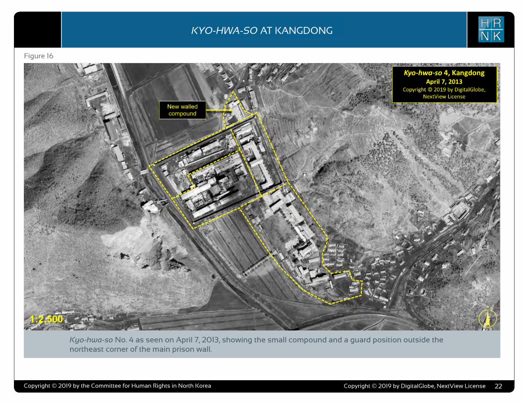
COPYRIGHT ©ALLSOURCE ANALYSIS, INC. 2016 3
H RN K
C H ’ O M A - B O N G R E S T R I C T E D A R E AH RN K
C A M P N O . 2 5
analysis also supports escapee and other reports indicating that Camp No. 25’s primary economic activity is focused on light industry and agriculture. Despite extensive satellite imagery coverage of the camp, AllSource is presently unable to confirm or deny escapee and open-source reports that the camp has a prisoner population of 5,000 people.
As with the analytical caution presented in previous reports (such as North Korea: Imagery Analysis Camp 16 and North Korea: Imagery Analysis of Camp 14 produced by HRNK and AllSource Analysis), it is important to reiterate that North Korean officials, especially those within the Korean People’s Army and the internal security organizations, clearly understand the importance of implementing camouflage, concealment, and deception (CCD) procedures to mask their operations and intentions.3 It would be reasonable to assume that they have done so here.
Location and Organization
Camp No. 25 is under the control of the
3 Bermudez Jr., Joseph S., Dinville, Andy and Eley, Mike. Imagery Analysis of Camp 16, (Washington, D.C.: The Committee for Human Rights in North Korea [HRNK], 2015) available at https://www.hrnk.org/uploads/pdfs/ASA_HRNK_Camp16_v8_full-res_FINAL_12_15_15.pdf and Bermudez Jr., Joseph S. Imagery Analysis: North Korea’s Camp No. 15, Update, (Washington, D.C.: HRNK, 2014) available at http://hrnk.org/uploads/pdfs/Camp%2025%20Update%20Good.pdf.
Prisons Bureau of the State Security Department (SSD), which is under the de facto control of the KWP OGD. Specifically, it is under the control of the SSD's North Hamgyong Provincial Bureau and is located approximately 7.5 km northwestof the port of Ch’ŏng-jin-si in Susŏng-dong, Ch’ŏngjin-si, Hamgyŏng-bukto.4 More specifically, it is
4 It is interesting to note that although the escapee descriptions of this facility’s mission matches that of other kwan-li-so, the physical characteristics ob-served in satellite imagery are more representative of the nation’s kyo-hwa-so, or long-term, felony penitentiaries and prison camps. David Hawk, The Hidden Gulag: Second Edition, Washington, D.C.: Committee for Human Rights in North Korea, 2012, www.hrnk.org/uploads/pdfs/HRNK_HiddenGu-lag2_Web_5-18.pdf. Another sources describes Camp No. 25 this way,
It is not structured as a village but is a fenced facility that looks like an ordinary prison camp [kyo-hwa-so] and is designed for collective living arrangements. The No. 25 [kwan-li-so] houses political prisoners only, while those who committed economic crimes are not allowed into the facility. Some inmates are released upon completion of their term as terms are fixed. Political criminals are detained alone with-out their families. …North Korean defector XXX [sic] testified, “Military personnel are sent off to the Susong kyo-hwa-so [No. 25 kwan-li-so] if their alleged crimes are of a political nature. The Susong kyo-hwa-so [No. 25 kwan-li-so] is for those serving terms of 10 years or longer, but they can return to society once they complete these terms.” It was also testified that the No. 25 kwan-li-so housed senior staff at the Provincial Party, the head of a local MPS office, and other high-ranking officials. North Korean defector XXX [sic] testified that the father of his
located on the south bank of the Sol-gol-ch’ŏn (i.e., Solgol stream) across from the village of Susŏng-dong, to which one foot and two road bridges connect it.
The date of establishment of Camp No. 25 is unclear. One report indicates that the camp was used as a prisoner-of-war camp housing South Korean soldiers at the end of the Korean War.5 This, how-ever, remains to be verified as it may not be referring to the present day camp but rather to an activity in this area. The area in which it is located has been involved in agricultural activities since at least the 1950s. Satellite imagery does indicate that Camp No. 25 was established prior to May 28, 1970, at which time it occupied an irregular shaped area that measured approximately 577 meters by 315 meters (631 yards by 344 yards) and encompassed 13.76 hectares (164,568
friend used to perform the duty of turning over Korean War POWs to South Korea, but he was arrested while attempting to cross the border at the river in Namyang, Onsung County, North Hamgyoung Province. He ended up at the No. 25 kwan-li-so in Chongjin.
Do Kyung-Ok et al., White Paper on Human Rights in North Korea 2015 (Seoul: Korea Institute for National Unification, 2015), p. 122, available at http://www.kinu.or.kr/eng/pub/pub_04_01.jsp.
5 “After the Korean War, it was used as a detention facility for South Korean POWs (Prisoners of War).” Do Kyung-Ok et al., White Paper on Human Rights in North Korea 2015 (Seoul: Korea Institute for National Unification, 2015), p. 122, available at http://www.kinu.or.kr/eng/pub/pub_04_01.jsp.
square yards) and was expanded slightly by January 27, 1976, when it measured approximately 700 meters by 315 meters (765 yards by 344 yards) and encom-passed 15.30 hectares (181,987 square yards) (Figure 1, Figure 2).6
High-resolution satellite imagery from January 18, 2003, through September 21, 2015, indicates that the camp has expanded during this period and that its primary economic activities are centered on agriculture and light industry (Figure 3 through Figure 15).
Several small villages and military facilities are located in the general area around the camp. The camp is connected to the regional electric power grid via overhead high voltage power transmis-sion cables that run from the camp to the substation approximately 1 kilometer to the southeast. It is connected to the national rail network via the station at Susŏng-dong, 800 meters to the east of the facility (Figure 16). The closest air facility to Camp No. 25 is the Korean People’s Air Force’s Sŭngam-ni Air Base, located 18 kilometers south-southwest. This is a training base, and based on its mission, organization, and location, almost certainly provides no support to Camp No. 25.
6 HRNK anticipates that we will be able to further refine the date of the camps establishment in future updates. Referenced imagery includes: KH-4B imagery dated May 28, 1970 and KH-9 (mapping camera) imagery dated January 27, 1976.
North Korea: Imagery Analysis of Camp No. 25 - Update 2
H RN KKYO-HWA-SO AT KANGDONG
Copyright © 2019 by the Committee for Human Rights in North Korea 22
Figure 16
Kyo-hwa-so No. 4 as seen on April 7, 2013, showing the small compound and a guard position outside the northeast corner of the main prison wall.
Copyright © 2019 by DigitalGlobe, NextView License
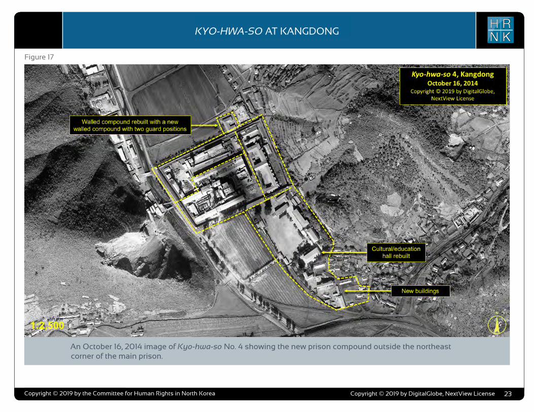
COPYRIGHT ©ALLSOURCE ANALYSIS, INC. 2016 3
H RN K
C H ’ O M A - B O N G R E S T R I C T E D A R E AH RN K
C A M P N O . 2 5
analysis also supports escapee and other reports indicating that Camp No. 25’s primary economic activity is focused on light industry and agriculture. Despite extensive satellite imagery coverage of the camp, AllSource is presently unable to confirm or deny escapee and open-source reports that the camp has a prisoner population of 5,000 people.
As with the analytical caution presented in previous reports (such as North Korea: Imagery Analysis Camp 16 and North Korea: Imagery Analysis of Camp 14 produced by HRNK and AllSource Analysis), it is important to reiterate that North Korean officials, especially those within the Korean People’s Army and the internal security organizations, clearly understand the importance of implementing camouflage, concealment, and deception (CCD) procedures to mask their operations and intentions.3 It would be reasonable to assume that they have done so here.
Location and Organization
Camp No. 25 is under the control of the
3 Bermudez Jr., Joseph S., Dinville, Andy and Eley, Mike. Imagery Analysis of Camp 16, (Washington, D.C.: The Committee for Human Rights in North Korea [HRNK], 2015) available at https://www.hrnk.org/uploads/pdfs/ASA_HRNK_Camp16_v8_full-res_FINAL_12_15_15.pdf and Bermudez Jr., Joseph S. Imagery Analysis: North Korea’s Camp No. 15, Update, (Washington, D.C.: HRNK, 2014) available at http://hrnk.org/uploads/pdfs/Camp%2025%20Update%20Good.pdf.
Prisons Bureau of the State Security Department (SSD), which is under the de facto control of the KWP OGD. Specifically, it is under the control of the SSD's North Hamgyong Provincial Bureau and is located approximately 7.5 km northwestof the port of Ch’ŏng-jin-si in Susŏng-dong, Ch’ŏngjin-si, Hamgyŏng-bukto.4 More specifically, it is
4 It is interesting to note that although the escapee descriptions of this facility’s mission matches that of other kwan-li-so, the physical characteristics ob-served in satellite imagery are more representative of the nation’s kyo-hwa-so, or long-term, felony penitentiaries and prison camps. David Hawk, The Hidden Gulag: Second Edition, Washington, D.C.: Committee for Human Rights in North Korea, 2012, www.hrnk.org/uploads/pdfs/HRNK_HiddenGu-lag2_Web_5-18.pdf. Another sources describes Camp No. 25 this way,
It is not structured as a village but is a fenced facility that looks like an ordinary prison camp [kyo-hwa-so] and is designed for collective living arrangements. The No. 25 [kwan-li-so] houses political prisoners only, while those who committed economic crimes are not allowed into the facility. Some inmates are released upon completion of their term as terms are fixed. Political criminals are detained alone with-out their families. …North Korean defector XXX [sic] testified, “Military personnel are sent off to the Susong kyo-hwa-so [No. 25 kwan-li-so] if their alleged crimes are of a political nature. The Susong kyo-hwa-so [No. 25 kwan-li-so] is for those serving terms of 10 years or longer, but they can return to society once they complete these terms.” It was also testified that the No. 25 kwan-li-so housed senior staff at the Provincial Party, the head of a local MPS office, and other high-ranking officials. North Korean defector XXX [sic] testified that the father of his
located on the south bank of the Sol-gol-ch’ŏn (i.e., Solgol stream) across from the village of Susŏng-dong, to which one foot and two road bridges connect it.
The date of establishment of Camp No. 25 is unclear. One report indicates that the camp was used as a prisoner-of-war camp housing South Korean soldiers at the end of the Korean War.5 This, how-ever, remains to be verified as it may not be referring to the present day camp but rather to an activity in this area. The area in which it is located has been involved in agricultural activities since at least the 1950s. Satellite imagery does indicate that Camp No. 25 was established prior to May 28, 1970, at which time it occupied an irregular shaped area that measured approximately 577 meters by 315 meters (631 yards by 344 yards) and encompassed 13.76 hectares (164,568
friend used to perform the duty of turning over Korean War POWs to South Korea, but he was arrested while attempting to cross the border at the river in Namyang, Onsung County, North Hamgyoung Province. He ended up at the No. 25 kwan-li-so in Chongjin.
Do Kyung-Ok et al., White Paper on Human Rights in North Korea 2015 (Seoul: Korea Institute for National Unification, 2015), p. 122, available at http://www.kinu.or.kr/eng/pub/pub_04_01.jsp.
5 “After the Korean War, it was used as a detention facility for South Korean POWs (Prisoners of War).” Do Kyung-Ok et al., White Paper on Human Rights in North Korea 2015 (Seoul: Korea Institute for National Unification, 2015), p. 122, available at http://www.kinu.or.kr/eng/pub/pub_04_01.jsp.
square yards) and was expanded slightly by January 27, 1976, when it measured approximately 700 meters by 315 meters (765 yards by 344 yards) and encom-passed 15.30 hectares (181,987 square yards) (Figure 1, Figure 2).6
High-resolution satellite imagery from January 18, 2003, through September 21, 2015, indicates that the camp has expanded during this period and that its primary economic activities are centered on agriculture and light industry (Figure 3 through Figure 15).
Several small villages and military facilities are located in the general area around the camp. The camp is connected to the regional electric power grid via overhead high voltage power transmis-sion cables that run from the camp to the substation approximately 1 kilometer to the southeast. It is connected to the national rail network via the station at Susŏng-dong, 800 meters to the east of the facility (Figure 16). The closest air facility to Camp No. 25 is the Korean People’s Air Force’s Sŭngam-ni Air Base, located 18 kilometers south-southwest. This is a training base, and based on its mission, organization, and location, almost certainly provides no support to Camp No. 25.
6 HRNK anticipates that we will be able to further refine the date of the camps establishment in future updates. Referenced imagery includes: KH-4B imagery dated May 28, 1970 and KH-9 (mapping camera) imagery dated January 27, 1976.
North Korea: Imagery Analysis of Camp No. 25 - Update 2
H RN KKYO-HWA-SO AT KANGDONG
Copyright © 2019 by the Committee for Human Rights in North Korea 23
Figure 17
An October 16, 2014 image of Kyo-hwa-so No. 4 showing the new prison compound outside the northeast corner of the main prison.
Copyright © 2019 by DigitalGlobe, NextView License
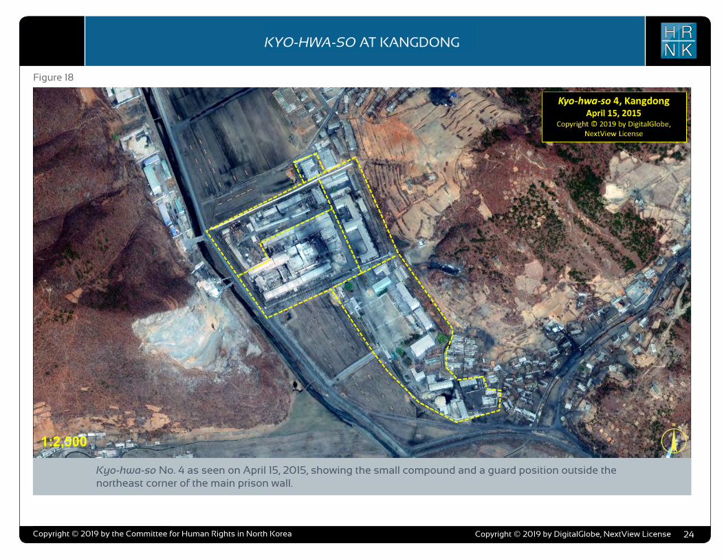
COPYRIGHT ©ALLSOURCE ANALYSIS, INC. 2016 3
H RN K
C H ’ O M A - B O N G R E S T R I C T E D A R E AH RN K
C A M P N O . 2 5
analysis also supports escapee and other reports indicating that Camp No. 25’s primary economic activity is focused on light industry and agriculture. Despite extensive satellite imagery coverage of the camp, AllSource is presently unable to confirm or deny escapee and open-source reports that the camp has a prisoner population of 5,000 people.
As with the analytical caution presented in previous reports (such as North Korea: Imagery Analysis Camp 16 and North Korea: Imagery Analysis of Camp 14 produced by HRNK and AllSource Analysis), it is important to reiterate that North Korean officials, especially those within the Korean People’s Army and the internal security organizations, clearly understand the importance of implementing camouflage, concealment, and deception (CCD) procedures to mask their operations and intentions.3 It would be reasonable to assume that they have done so here.
Location and Organization
Camp No. 25 is under the control of the
3 Bermudez Jr., Joseph S., Dinville, Andy and Eley, Mike. Imagery Analysis of Camp 16, (Washington, D.C.: The Committee for Human Rights in North Korea [HRNK], 2015) available at https://www.hrnk.org/uploads/pdfs/ASA_HRNK_Camp16_v8_full-res_FINAL_12_15_15.pdf and Bermudez Jr., Joseph S. Imagery Analysis: North Korea’s Camp No. 15, Update, (Washington, D.C.: HRNK, 2014) available at http://hrnk.org/uploads/pdfs/Camp%2025%20Update%20Good.pdf.
Prisons Bureau of the State Security Department (SSD), which is under the de facto control of the KWP OGD. Specifically, it is under the control of the SSD's North Hamgyong Provincial Bureau and is located approximately 7.5 km northwestof the port of Ch’ŏng-jin-si in Susŏng-dong, Ch’ŏngjin-si, Hamgyŏng-bukto.4 More specifically, it is
4 It is interesting to note that although the escapee descriptions of this facility’s mission matches that of other kwan-li-so, the physical characteristics ob-served in satellite imagery are more representative of the nation’s kyo-hwa-so, or long-term, felony penitentiaries and prison camps. David Hawk, The Hidden Gulag: Second Edition, Washington, D.C.: Committee for Human Rights in North Korea, 2012, www.hrnk.org/uploads/pdfs/HRNK_HiddenGu-lag2_Web_5-18.pdf. Another sources describes Camp No. 25 this way,
It is not structured as a village but is a fenced facility that looks like an ordinary prison camp [kyo-hwa-so] and is designed for collective living arrangements. The No. 25 [kwan-li-so] houses political prisoners only, while those who committed economic crimes are not allowed into the facility. Some inmates are released upon completion of their term as terms are fixed. Political criminals are detained alone with-out their families. …North Korean defector XXX [sic] testified, “Military personnel are sent off to the Susong kyo-hwa-so [No. 25 kwan-li-so] if their alleged crimes are of a political nature. The Susong kyo-hwa-so [No. 25 kwan-li-so] is for those serving terms of 10 years or longer, but they can return to society once they complete these terms.” It was also testified that the No. 25 kwan-li-so housed senior staff at the Provincial Party, the head of a local MPS office, and other high-ranking officials. North Korean defector XXX [sic] testified that the father of his
located on the south bank of the Sol-gol-ch’ŏn (i.e., Solgol stream) across from the village of Susŏng-dong, to which one foot and two road bridges connect it.
The date of establishment of Camp No. 25 is unclear. One report indicates that the camp was used as a prisoner-of-war camp housing South Korean soldiers at the end of the Korean War.5 This, how-ever, remains to be verified as it may not be referring to the present day camp but rather to an activity in this area. The area in which it is located has been involved in agricultural activities since at least the 1950s. Satellite imagery does indicate that Camp No. 25 was established prior to May 28, 1970, at which time it occupied an irregular shaped area that measured approximately 577 meters by 315 meters (631 yards by 344 yards) and encompassed 13.76 hectares (164,568
friend used to perform the duty of turning over Korean War POWs to South Korea, but he was arrested while attempting to cross the border at the river in Namyang, Onsung County, North Hamgyoung Province. He ended up at the No. 25 kwan-li-so in Chongjin.
Do Kyung-Ok et al., White Paper on Human Rights in North Korea 2015 (Seoul: Korea Institute for National Unification, 2015), p. 122, available at http://www.kinu.or.kr/eng/pub/pub_04_01.jsp.
5 “After the Korean War, it was used as a detention facility for South Korean POWs (Prisoners of War).” Do Kyung-Ok et al., White Paper on Human Rights in North Korea 2015 (Seoul: Korea Institute for National Unification, 2015), p. 122, available at http://www.kinu.or.kr/eng/pub/pub_04_01.jsp.
square yards) and was expanded slightly by January 27, 1976, when it measured approximately 700 meters by 315 meters (765 yards by 344 yards) and encom-passed 15.30 hectares (181,987 square yards) (Figure 1, Figure 2).6
High-resolution satellite imagery from January 18, 2003, through September 21, 2015, indicates that the camp has expanded during this period and that its primary economic activities are centered on agriculture and light industry (Figure 3 through Figure 15).
Several small villages and military facilities are located in the general area around the camp. The camp is connected to the regional electric power grid via overhead high voltage power transmis-sion cables that run from the camp to the substation approximately 1 kilometer to the southeast. It is connected to the national rail network via the station at Susŏng-dong, 800 meters to the east of the facility (Figure 16). The closest air facility to Camp No. 25 is the Korean People’s Air Force’s Sŭngam-ni Air Base, located 18 kilometers south-southwest. This is a training base, and based on its mission, organization, and location, almost certainly provides no support to Camp No. 25.
6 HRNK anticipates that we will be able to further refine the date of the camps establishment in future updates. Referenced imagery includes: KH-4B imagery dated May 28, 1970 and KH-9 (mapping camera) imagery dated January 27, 1976.
North Korea: Imagery Analysis of Camp No. 25 - Update 2
H RN KKYO-HWA-SO AT KANGDONG
Copyright © 2019 by the Committee for Human Rights in North Korea 24
Figure 18
Kyo-hwa-so No. 4 as seen on April 15, 2015, showing the small compound and a guard position outside the northeast corner of the main prison wall.
Copyright © 2019 by DigitalGlobe, NextView License

COPYRIGHT ©ALLSOURCE ANALYSIS, INC. 2016 3
H RN K
C H ’ O M A - B O N G R E S T R I C T E D A R E AH RN K
C A M P N O . 2 5
analysis also supports escapee and other reports indicating that Camp No. 25’s primary economic activity is focused on light industry and agriculture. Despite extensive satellite imagery coverage of the camp, AllSource is presently unable to confirm or deny escapee and open-source reports that the camp has a prisoner population of 5,000 people.
As with the analytical caution presented in previous reports (such as North Korea: Imagery Analysis Camp 16 and North Korea: Imagery Analysis of Camp 14 produced by HRNK and AllSource Analysis), it is important to reiterate that North Korean officials, especially those within the Korean People’s Army and the internal security organizations, clearly understand the importance of implementing camouflage, concealment, and deception (CCD) procedures to mask their operations and intentions.3 It would be reasonable to assume that they have done so here.
Location and Organization
Camp No. 25 is under the control of the
3 Bermudez Jr., Joseph S., Dinville, Andy and Eley, Mike. Imagery Analysis of Camp 16, (Washington, D.C.: The Committee for Human Rights in North Korea [HRNK], 2015) available at https://www.hrnk.org/uploads/pdfs/ASA_HRNK_Camp16_v8_full-res_FINAL_12_15_15.pdf and Bermudez Jr., Joseph S. Imagery Analysis: North Korea’s Camp No. 15, Update, (Washington, D.C.: HRNK, 2014) available at http://hrnk.org/uploads/pdfs/Camp%2025%20Update%20Good.pdf.
Prisons Bureau of the State Security Department (SSD), which is under the de facto control of the KWP OGD. Specifically, it is under the control of the SSD's North Hamgyong Provincial Bureau and is located approximately 7.5 km northwestof the port of Ch’ŏng-jin-si in Susŏng-dong, Ch’ŏngjin-si, Hamgyŏng-bukto.4 More specifically, it is
4 It is interesting to note that although the escapee descriptions of this facility’s mission matches that of other kwan-li-so, the physical characteristics ob-served in satellite imagery are more representative of the nation’s kyo-hwa-so, or long-term, felony penitentiaries and prison camps. David Hawk, The Hidden Gulag: Second Edition, Washington, D.C.: Committee for Human Rights in North Korea, 2012, www.hrnk.org/uploads/pdfs/HRNK_HiddenGu-lag2_Web_5-18.pdf. Another sources describes Camp No. 25 this way,
It is not structured as a village but is a fenced facility that looks like an ordinary prison camp [kyo-hwa-so] and is designed for collective living arrangements. The No. 25 [kwan-li-so] houses political prisoners only, while those who committed economic crimes are not allowed into the facility. Some inmates are released upon completion of their term as terms are fixed. Political criminals are detained alone with-out their families. …North Korean defector XXX [sic] testified, “Military personnel are sent off to the Susong kyo-hwa-so [No. 25 kwan-li-so] if their alleged crimes are of a political nature. The Susong kyo-hwa-so [No. 25 kwan-li-so] is for those serving terms of 10 years or longer, but they can return to society once they complete these terms.” It was also testified that the No. 25 kwan-li-so housed senior staff at the Provincial Party, the head of a local MPS office, and other high-ranking officials. North Korean defector XXX [sic] testified that the father of his
located on the south bank of the Sol-gol-ch’ŏn (i.e., Solgol stream) across from the village of Susŏng-dong, to which one foot and two road bridges connect it.
The date of establishment of Camp No. 25 is unclear. One report indicates that the camp was used as a prisoner-of-war camp housing South Korean soldiers at the end of the Korean War.5 This, how-ever, remains to be verified as it may not be referring to the present day camp but rather to an activity in this area. The area in which it is located has been involved in agricultural activities since at least the 1950s. Satellite imagery does indicate that Camp No. 25 was established prior to May 28, 1970, at which time it occupied an irregular shaped area that measured approximately 577 meters by 315 meters (631 yards by 344 yards) and encompassed 13.76 hectares (164,568
friend used to perform the duty of turning over Korean War POWs to South Korea, but he was arrested while attempting to cross the border at the river in Namyang, Onsung County, North Hamgyoung Province. He ended up at the No. 25 kwan-li-so in Chongjin.
Do Kyung-Ok et al., White Paper on Human Rights in North Korea 2015 (Seoul: Korea Institute for National Unification, 2015), p. 122, available at http://www.kinu.or.kr/eng/pub/pub_04_01.jsp.
5 “After the Korean War, it was used as a detention facility for South Korean POWs (Prisoners of War).” Do Kyung-Ok et al., White Paper on Human Rights in North Korea 2015 (Seoul: Korea Institute for National Unification, 2015), p. 122, available at http://www.kinu.or.kr/eng/pub/pub_04_01.jsp.
square yards) and was expanded slightly by January 27, 1976, when it measured approximately 700 meters by 315 meters (765 yards by 344 yards) and encom-passed 15.30 hectares (181,987 square yards) (Figure 1, Figure 2).6
High-resolution satellite imagery from January 18, 2003, through September 21, 2015, indicates that the camp has expanded during this period and that its primary economic activities are centered on agriculture and light industry (Figure 3 through Figure 15).
Several small villages and military facilities are located in the general area around the camp. The camp is connected to the regional electric power grid via overhead high voltage power transmis-sion cables that run from the camp to the substation approximately 1 kilometer to the southeast. It is connected to the national rail network via the station at Susŏng-dong, 800 meters to the east of the facility (Figure 16). The closest air facility to Camp No. 25 is the Korean People’s Air Force’s Sŭngam-ni Air Base, located 18 kilometers south-southwest. This is a training base, and based on its mission, organization, and location, almost certainly provides no support to Camp No. 25.
6 HRNK anticipates that we will be able to further refine the date of the camps establishment in future updates. Referenced imagery includes: KH-4B imagery dated May 28, 1970 and KH-9 (mapping camera) imagery dated January 27, 1976.
North Korea: Imagery Analysis of Camp No. 25 - Update 2
H RN KKYO-HWA-SO AT KANGDONG
Copyright © 2019 by the Committee for Human Rights in North Korea 25
Figure 19
An October 13, 2016 view of Kyo-hwa-so No. 4.
Copyright © 2019 by DigitalGlobe, NextView License
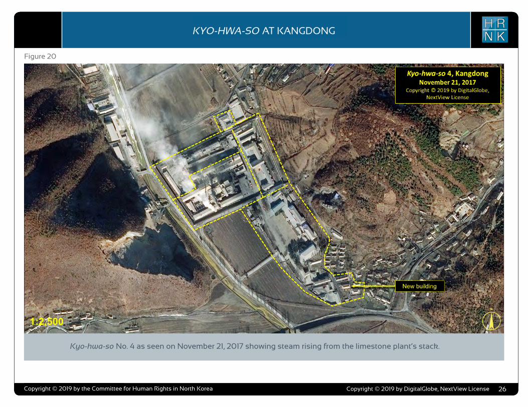
COPYRIGHT ©ALLSOURCE ANALYSIS, INC. 2016 3
H RN K
C H ’ O M A - B O N G R E S T R I C T E D A R E AH RN K
C A M P N O . 2 5
analysis also supports escapee and other reports indicating that Camp No. 25’s primary economic activity is focused on light industry and agriculture. Despite extensive satellite imagery coverage of the camp, AllSource is presently unable to confirm or deny escapee and open-source reports that the camp has a prisoner population of 5,000 people.
As with the analytical caution presented in previous reports (such as North Korea: Imagery Analysis Camp 16 and North Korea: Imagery Analysis of Camp 14 produced by HRNK and AllSource Analysis), it is important to reiterate that North Korean officials, especially those within the Korean People’s Army and the internal security organizations, clearly understand the importance of implementing camouflage, concealment, and deception (CCD) procedures to mask their operations and intentions.3 It would be reasonable to assume that they have done so here.
Location and Organization
Camp No. 25 is under the control of the
3 Bermudez Jr., Joseph S., Dinville, Andy and Eley, Mike. Imagery Analysis of Camp 16, (Washington, D.C.: The Committee for Human Rights in North Korea [HRNK], 2015) available at https://www.hrnk.org/uploads/pdfs/ASA_HRNK_Camp16_v8_full-res_FINAL_12_15_15.pdf and Bermudez Jr., Joseph S. Imagery Analysis: North Korea’s Camp No. 15, Update, (Washington, D.C.: HRNK, 2014) available at http://hrnk.org/uploads/pdfs/Camp%2025%20Update%20Good.pdf.
Prisons Bureau of the State Security Department (SSD), which is under the de facto control of the KWP OGD. Specifically, it is under the control of the SSD's North Hamgyong Provincial Bureau and is located approximately 7.5 km northwestof the port of Ch’ŏng-jin-si in Susŏng-dong, Ch’ŏngjin-si, Hamgyŏng-bukto.4 More specifically, it is
4 It is interesting to note that although the escapee descriptions of this facility’s mission matches that of other kwan-li-so, the physical characteristics ob-served in satellite imagery are more representative of the nation’s kyo-hwa-so, or long-term, felony penitentiaries and prison camps. David Hawk, The Hidden Gulag: Second Edition, Washington, D.C.: Committee for Human Rights in North Korea, 2012, www.hrnk.org/uploads/pdfs/HRNK_HiddenGu-lag2_Web_5-18.pdf. Another sources describes Camp No. 25 this way,
It is not structured as a village but is a fenced facility that looks like an ordinary prison camp [kyo-hwa-so] and is designed for collective living arrangements. The No. 25 [kwan-li-so] houses political prisoners only, while those who committed economic crimes are not allowed into the facility. Some inmates are released upon completion of their term as terms are fixed. Political criminals are detained alone with-out their families. …North Korean defector XXX [sic] testified, “Military personnel are sent off to the Susong kyo-hwa-so [No. 25 kwan-li-so] if their alleged crimes are of a political nature. The Susong kyo-hwa-so [No. 25 kwan-li-so] is for those serving terms of 10 years or longer, but they can return to society once they complete these terms.” It was also testified that the No. 25 kwan-li-so housed senior staff at the Provincial Party, the head of a local MPS office, and other high-ranking officials. North Korean defector XXX [sic] testified that the father of his
located on the south bank of the Sol-gol-ch’ŏn (i.e., Solgol stream) across from the village of Susŏng-dong, to which one foot and two road bridges connect it.
The date of establishment of Camp No. 25 is unclear. One report indicates that the camp was used as a prisoner-of-war camp housing South Korean soldiers at the end of the Korean War.5 This, how-ever, remains to be verified as it may not be referring to the present day camp but rather to an activity in this area. The area in which it is located has been involved in agricultural activities since at least the 1950s. Satellite imagery does indicate that Camp No. 25 was established prior to May 28, 1970, at which time it occupied an irregular shaped area that measured approximately 577 meters by 315 meters (631 yards by 344 yards) and encompassed 13.76 hectares (164,568
friend used to perform the duty of turning over Korean War POWs to South Korea, but he was arrested while attempting to cross the border at the river in Namyang, Onsung County, North Hamgyoung Province. He ended up at the No. 25 kwan-li-so in Chongjin.
Do Kyung-Ok et al., White Paper on Human Rights in North Korea 2015 (Seoul: Korea Institute for National Unification, 2015), p. 122, available at http://www.kinu.or.kr/eng/pub/pub_04_01.jsp.
5 “After the Korean War, it was used as a detention facility for South Korean POWs (Prisoners of War).” Do Kyung-Ok et al., White Paper on Human Rights in North Korea 2015 (Seoul: Korea Institute for National Unification, 2015), p. 122, available at http://www.kinu.or.kr/eng/pub/pub_04_01.jsp.
square yards) and was expanded slightly by January 27, 1976, when it measured approximately 700 meters by 315 meters (765 yards by 344 yards) and encom-passed 15.30 hectares (181,987 square yards) (Figure 1, Figure 2).6
High-resolution satellite imagery from January 18, 2003, through September 21, 2015, indicates that the camp has expanded during this period and that its primary economic activities are centered on agriculture and light industry (Figure 3 through Figure 15).
Several small villages and military facilities are located in the general area around the camp. The camp is connected to the regional electric power grid via overhead high voltage power transmis-sion cables that run from the camp to the substation approximately 1 kilometer to the southeast. It is connected to the national rail network via the station at Susŏng-dong, 800 meters to the east of the facility (Figure 16). The closest air facility to Camp No. 25 is the Korean People’s Air Force’s Sŭngam-ni Air Base, located 18 kilometers south-southwest. This is a training base, and based on its mission, organization, and location, almost certainly provides no support to Camp No. 25.
6 HRNK anticipates that we will be able to further refine the date of the camps establishment in future updates. Referenced imagery includes: KH-4B imagery dated May 28, 1970 and KH-9 (mapping camera) imagery dated January 27, 1976.
North Korea: Imagery Analysis of Camp No. 25 - Update 2
H RN KKYO-HWA-SO AT KANGDONG
Copyright © 2019 by the Committee for Human Rights in North Korea 26
Figure 20
Kyo-hwa-so No. 4 as seen on November 21, 2017 showing steam rising from the limestone plant’s stack.
Copyright © 2019 by DigitalGlobe, NextView License

COPYRIGHT ©ALLSOURCE ANALYSIS, INC. 2016 3
H RN K
C H ’ O M A - B O N G R E S T R I C T E D A R E AH RN K
C A M P N O . 2 5
analysis also supports escapee and other reports indicating that Camp No. 25’s primary economic activity is focused on light industry and agriculture. Despite extensive satellite imagery coverage of the camp, AllSource is presently unable to confirm or deny escapee and open-source reports that the camp has a prisoner population of 5,000 people.
As with the analytical caution presented in previous reports (such as North Korea: Imagery Analysis Camp 16 and North Korea: Imagery Analysis of Camp 14 produced by HRNK and AllSource Analysis), it is important to reiterate that North Korean officials, especially those within the Korean People’s Army and the internal security organizations, clearly understand the importance of implementing camouflage, concealment, and deception (CCD) procedures to mask their operations and intentions.3 It would be reasonable to assume that they have done so here.
Location and Organization
Camp No. 25 is under the control of the
3 Bermudez Jr., Joseph S., Dinville, Andy and Eley, Mike. Imagery Analysis of Camp 16, (Washington, D.C.: The Committee for Human Rights in North Korea [HRNK], 2015) available at https://www.hrnk.org/uploads/pdfs/ASA_HRNK_Camp16_v8_full-res_FINAL_12_15_15.pdf and Bermudez Jr., Joseph S. Imagery Analysis: North Korea’s Camp No. 15, Update, (Washington, D.C.: HRNK, 2014) available at http://hrnk.org/uploads/pdfs/Camp%2025%20Update%20Good.pdf.
Prisons Bureau of the State Security Department (SSD), which is under the de facto control of the KWP OGD. Specifically, it is under the control of the SSD's North Hamgyong Provincial Bureau and is located approximately 7.5 km northwestof the port of Ch’ŏng-jin-si in Susŏng-dong, Ch’ŏngjin-si, Hamgyŏng-bukto.4 More specifically, it is
4 It is interesting to note that although the escapee descriptions of this facility’s mission matches that of other kwan-li-so, the physical characteristics ob-served in satellite imagery are more representative of the nation’s kyo-hwa-so, or long-term, felony penitentiaries and prison camps. David Hawk, The Hidden Gulag: Second Edition, Washington, D.C.: Committee for Human Rights in North Korea, 2012, www.hrnk.org/uploads/pdfs/HRNK_HiddenGu-lag2_Web_5-18.pdf. Another sources describes Camp No. 25 this way,
It is not structured as a village but is a fenced facility that looks like an ordinary prison camp [kyo-hwa-so] and is designed for collective living arrangements. The No. 25 [kwan-li-so] houses political prisoners only, while those who committed economic crimes are not allowed into the facility. Some inmates are released upon completion of their term as terms are fixed. Political criminals are detained alone with-out their families. …North Korean defector XXX [sic] testified, “Military personnel are sent off to the Susong kyo-hwa-so [No. 25 kwan-li-so] if their alleged crimes are of a political nature. The Susong kyo-hwa-so [No. 25 kwan-li-so] is for those serving terms of 10 years or longer, but they can return to society once they complete these terms.” It was also testified that the No. 25 kwan-li-so housed senior staff at the Provincial Party, the head of a local MPS office, and other high-ranking officials. North Korean defector XXX [sic] testified that the father of his
located on the south bank of the Sol-gol-ch’ŏn (i.e., Solgol stream) across from the village of Susŏng-dong, to which one foot and two road bridges connect it.
The date of establishment of Camp No. 25 is unclear. One report indicates that the camp was used as a prisoner-of-war camp housing South Korean soldiers at the end of the Korean War.5 This, how-ever, remains to be verified as it may not be referring to the present day camp but rather to an activity in this area. The area in which it is located has been involved in agricultural activities since at least the 1950s. Satellite imagery does indicate that Camp No. 25 was established prior to May 28, 1970, at which time it occupied an irregular shaped area that measured approximately 577 meters by 315 meters (631 yards by 344 yards) and encompassed 13.76 hectares (164,568
friend used to perform the duty of turning over Korean War POWs to South Korea, but he was arrested while attempting to cross the border at the river in Namyang, Onsung County, North Hamgyoung Province. He ended up at the No. 25 kwan-li-so in Chongjin.
Do Kyung-Ok et al., White Paper on Human Rights in North Korea 2015 (Seoul: Korea Institute for National Unification, 2015), p. 122, available at http://www.kinu.or.kr/eng/pub/pub_04_01.jsp.
5 “After the Korean War, it was used as a detention facility for South Korean POWs (Prisoners of War).” Do Kyung-Ok et al., White Paper on Human Rights in North Korea 2015 (Seoul: Korea Institute for National Unification, 2015), p. 122, available at http://www.kinu.or.kr/eng/pub/pub_04_01.jsp.
square yards) and was expanded slightly by January 27, 1976, when it measured approximately 700 meters by 315 meters (765 yards by 344 yards) and encom-passed 15.30 hectares (181,987 square yards) (Figure 1, Figure 2).6
High-resolution satellite imagery from January 18, 2003, through September 21, 2015, indicates that the camp has expanded during this period and that its primary economic activities are centered on agriculture and light industry (Figure 3 through Figure 15).
Several small villages and military facilities are located in the general area around the camp. The camp is connected to the regional electric power grid via overhead high voltage power transmis-sion cables that run from the camp to the substation approximately 1 kilometer to the southeast. It is connected to the national rail network via the station at Susŏng-dong, 800 meters to the east of the facility (Figure 16). The closest air facility to Camp No. 25 is the Korean People’s Air Force’s Sŭngam-ni Air Base, located 18 kilometers south-southwest. This is a training base, and based on its mission, organization, and location, almost certainly provides no support to Camp No. 25.
6 HRNK anticipates that we will be able to further refine the date of the camps establishment in future updates. Referenced imagery includes: KH-4B imagery dated May 28, 1970 and KH-9 (mapping camera) imagery dated January 27, 1976.
North Korea: Imagery Analysis of Camp No. 25 - Update 2
H RN KKYO-HWA-SO AT KANGDONG
Copyright © 2019 by the Committee for Human Rights in North Korea 27
Figure 21
A view of Kyo-hwa-so No. 4 as seen on January 19, 2018.
Copyright © 2019 by DigitalGlobe, NextView License

COPYRIGHT ©ALLSOURCE ANALYSIS, INC. 2016 3
H RN K
C H ’ O M A - B O N G R E S T R I C T E D A R E AH RN K
C A M P N O . 2 5
analysis also supports escapee and other reports indicating that Camp No. 25’s primary economic activity is focused on light industry and agriculture. Despite extensive satellite imagery coverage of the camp, AllSource is presently unable to confirm or deny escapee and open-source reports that the camp has a prisoner population of 5,000 people.
As with the analytical caution presented in previous reports (such as North Korea: Imagery Analysis Camp 16 and North Korea: Imagery Analysis of Camp 14 produced by HRNK and AllSource Analysis), it is important to reiterate that North Korean officials, especially those within the Korean People’s Army and the internal security organizations, clearly understand the importance of implementing camouflage, concealment, and deception (CCD) procedures to mask their operations and intentions.3 It would be reasonable to assume that they have done so here.
Location and Organization
Camp No. 25 is under the control of the
3 Bermudez Jr., Joseph S., Dinville, Andy and Eley, Mike. Imagery Analysis of Camp 16, (Washington, D.C.: The Committee for Human Rights in North Korea [HRNK], 2015) available at https://www.hrnk.org/uploads/pdfs/ASA_HRNK_Camp16_v8_full-res_FINAL_12_15_15.pdf and Bermudez Jr., Joseph S. Imagery Analysis: North Korea’s Camp No. 15, Update, (Washington, D.C.: HRNK, 2014) available at http://hrnk.org/uploads/pdfs/Camp%2025%20Update%20Good.pdf.
Prisons Bureau of the State Security Department (SSD), which is under the de facto control of the KWP OGD. Specifically, it is under the control of the SSD's North Hamgyong Provincial Bureau and is located approximately 7.5 km northwestof the port of Ch’ŏng-jin-si in Susŏng-dong, Ch’ŏngjin-si, Hamgyŏng-bukto.4 More specifically, it is
4 It is interesting to note that although the escapee descriptions of this facility’s mission matches that of other kwan-li-so, the physical characteristics ob-served in satellite imagery are more representative of the nation’s kyo-hwa-so, or long-term, felony penitentiaries and prison camps. David Hawk, The Hidden Gulag: Second Edition, Washington, D.C.: Committee for Human Rights in North Korea, 2012, www.hrnk.org/uploads/pdfs/HRNK_HiddenGu-lag2_Web_5-18.pdf. Another sources describes Camp No. 25 this way,
It is not structured as a village but is a fenced facility that looks like an ordinary prison camp [kyo-hwa-so] and is designed for collective living arrangements. The No. 25 [kwan-li-so] houses political prisoners only, while those who committed economic crimes are not allowed into the facility. Some inmates are released upon completion of their term as terms are fixed. Political criminals are detained alone with-out their families. …North Korean defector XXX [sic] testified, “Military personnel are sent off to the Susong kyo-hwa-so [No. 25 kwan-li-so] if their alleged crimes are of a political nature. The Susong kyo-hwa-so [No. 25 kwan-li-so] is for those serving terms of 10 years or longer, but they can return to society once they complete these terms.” It was also testified that the No. 25 kwan-li-so housed senior staff at the Provincial Party, the head of a local MPS office, and other high-ranking officials. North Korean defector XXX [sic] testified that the father of his
located on the south bank of the Sol-gol-ch’ŏn (i.e., Solgol stream) across from the village of Susŏng-dong, to which one foot and two road bridges connect it.
The date of establishment of Camp No. 25 is unclear. One report indicates that the camp was used as a prisoner-of-war camp housing South Korean soldiers at the end of the Korean War.5 This, how-ever, remains to be verified as it may not be referring to the present day camp but rather to an activity in this area. The area in which it is located has been involved in agricultural activities since at least the 1950s. Satellite imagery does indicate that Camp No. 25 was established prior to May 28, 1970, at which time it occupied an irregular shaped area that measured approximately 577 meters by 315 meters (631 yards by 344 yards) and encompassed 13.76 hectares (164,568
friend used to perform the duty of turning over Korean War POWs to South Korea, but he was arrested while attempting to cross the border at the river in Namyang, Onsung County, North Hamgyoung Province. He ended up at the No. 25 kwan-li-so in Chongjin.
Do Kyung-Ok et al., White Paper on Human Rights in North Korea 2015 (Seoul: Korea Institute for National Unification, 2015), p. 122, available at http://www.kinu.or.kr/eng/pub/pub_04_01.jsp.
5 “After the Korean War, it was used as a detention facility for South Korean POWs (Prisoners of War).” Do Kyung-Ok et al., White Paper on Human Rights in North Korea 2015 (Seoul: Korea Institute for National Unification, 2015), p. 122, available at http://www.kinu.or.kr/eng/pub/pub_04_01.jsp.
square yards) and was expanded slightly by January 27, 1976, when it measured approximately 700 meters by 315 meters (765 yards by 344 yards) and encom-passed 15.30 hectares (181,987 square yards) (Figure 1, Figure 2).6
High-resolution satellite imagery from January 18, 2003, through September 21, 2015, indicates that the camp has expanded during this period and that its primary economic activities are centered on agriculture and light industry (Figure 3 through Figure 15).
Several small villages and military facilities are located in the general area around the camp. The camp is connected to the regional electric power grid via overhead high voltage power transmis-sion cables that run from the camp to the substation approximately 1 kilometer to the southeast. It is connected to the national rail network via the station at Susŏng-dong, 800 meters to the east of the facility (Figure 16). The closest air facility to Camp No. 25 is the Korean People’s Air Force’s Sŭngam-ni Air Base, located 18 kilometers south-southwest. This is a training base, and based on its mission, organization, and location, almost certainly provides no support to Camp No. 25.
6 HRNK anticipates that we will be able to further refine the date of the camps establishment in future updates. Referenced imagery includes: KH-4B imagery dated May 28, 1970 and KH-9 (mapping camera) imagery dated January 27, 1976.
North Korea: Imagery Analysis of Camp No. 25 - Update 2
H RN KKYO-HWA-SO AT KANGDONG
Copyright © 2019 by the Committee for Human Rights in North Korea 28
Imagery Analysis
Based upon limited publicly avail-able information and high-resolu-tion satellite imagery, Kyo-hwa-so No. 4 and its immediate surround-ings can be separated into six road areas:
» Security Perimeter and Guard Positions
» Prison Compounds and Limestone Plant
» Headquarters, Administra-tion, and Barracks
» Support and Housing » Limestone Quarry » Additional Activities
Security Perimeter and Guard Positions
The prison’s security perimeter consists of a combination of walls, entrances/checkpoints, and guard positions. These not only sepa-rate Kyo-hwa-so No. 4 from the surrounding countryside but also segment it internally. Neither the external perimeter of the camp nor the interior infrastructure have changed significantly since 2014.
The external perimeter, which sur-rounds the new prison compound, main prison compound, and the headquarters administration and barracks area, is approximately 1,900-meters-long (2,090-yards-long) and encompasses approx-imately 115,794 square meters (138,490 square yards). There are a total of five entrances to the facility—one entrance/check-point in the north wall of the new prison compound, one entrance/checkpoint in the south wall of the main prison compound, and one entrance/checkpoint and two additional entrances to the headquarters, administration, and barracks area.
A total of six guard positions are distributed atop the prison’s walls—four on the corners of the main prison and two on opposite corners of the smaller new prison compound (one of these is shared with the main prison). A seventh guard position appears to be on top of a tall support building north of the limestone plant. Finally, what appears to be an eighth guard position is located approx-
imately 50 meters northeast of the new prison compound, at the intersection of two gravel roads. Aside from its height and guard towers, the main prison wall is supplemented by an internal (presumably barbed-wire) fence set approximately three-meters inside the wall.
All walls and entrances/check-points appear to be well main-tained and in good repair. The guard positions are well posi-tioned to provide overlapping fields-of-view of the camp and appear to be well maintained and in good repair.
Prison Compounds and Limestone Plant
There are two sperate prison com-pounds at Kyo-hwa-so No. 4—the main prison and new prison.
The main prison is surrounded by an approximately 265-meter-by-190-meter high trapezoidal walled compound encompassing 51, 863 square meters and can be functionally separated into
three sections—limestone plant, plant support and plant admin-istration, and prisoner housing. The limestone plant occupies the southwest section of the main prison compound and has been active in numerous images as is indicated by the presence of smoke/exhaust above the crush-ing, grinding, and kiln areas or emanating from the plant’s main stack. The plant’s three large storage silos, tall exhaust stack, and rotary kiln are clearly visi-ble in all satellite imagery. This imagery indicates that the plant can produce products typical of many small limestone plants. The presence of the rotary kiln also indicates that the plant is capable of crushing and grinding limestone into limestone powder. Without proper safety measures—for which North Korean industry is not known—the inhalation of powdered limestone could lead to respiratory problems among workers. This has the potential to be significantly exacerbated by the fact that forced labor is used in the plant and the safety stan-dards are likely to be significantly
NORTH KOREA’S LONG-TERM PRISON-LABOR FACILITY (KYO-HWA-SO) AT KANGDONG

COPYRIGHT ©ALLSOURCE ANALYSIS, INC. 2016 3
H RN K
C H ’ O M A - B O N G R E S T R I C T E D A R E AH RN K
C A M P N O . 2 5
analysis also supports escapee and other reports indicating that Camp No. 25’s primary economic activity is focused on light industry and agriculture. Despite extensive satellite imagery coverage of the camp, AllSource is presently unable to confirm or deny escapee and open-source reports that the camp has a prisoner population of 5,000 people.
As with the analytical caution presented in previous reports (such as North Korea: Imagery Analysis Camp 16 and North Korea: Imagery Analysis of Camp 14 produced by HRNK and AllSource Analysis), it is important to reiterate that North Korean officials, especially those within the Korean People’s Army and the internal security organizations, clearly understand the importance of implementing camouflage, concealment, and deception (CCD) procedures to mask their operations and intentions.3 It would be reasonable to assume that they have done so here.
Location and Organization
Camp No. 25 is under the control of the
3 Bermudez Jr., Joseph S., Dinville, Andy and Eley, Mike. Imagery Analysis of Camp 16, (Washington, D.C.: The Committee for Human Rights in North Korea [HRNK], 2015) available at https://www.hrnk.org/uploads/pdfs/ASA_HRNK_Camp16_v8_full-res_FINAL_12_15_15.pdf and Bermudez Jr., Joseph S. Imagery Analysis: North Korea’s Camp No. 15, Update, (Washington, D.C.: HRNK, 2014) available at http://hrnk.org/uploads/pdfs/Camp%2025%20Update%20Good.pdf.
Prisons Bureau of the State Security Department (SSD), which is under the de facto control of the KWP OGD. Specifically, it is under the control of the SSD's North Hamgyong Provincial Bureau and is located approximately 7.5 km northwestof the port of Ch’ŏng-jin-si in Susŏng-dong, Ch’ŏngjin-si, Hamgyŏng-bukto.4 More specifically, it is
4 It is interesting to note that although the escapee descriptions of this facility’s mission matches that of other kwan-li-so, the physical characteristics ob-served in satellite imagery are more representative of the nation’s kyo-hwa-so, or long-term, felony penitentiaries and prison camps. David Hawk, The Hidden Gulag: Second Edition, Washington, D.C.: Committee for Human Rights in North Korea, 2012, www.hrnk.org/uploads/pdfs/HRNK_HiddenGu-lag2_Web_5-18.pdf. Another sources describes Camp No. 25 this way,
It is not structured as a village but is a fenced facility that looks like an ordinary prison camp [kyo-hwa-so] and is designed for collective living arrangements. The No. 25 [kwan-li-so] houses political prisoners only, while those who committed economic crimes are not allowed into the facility. Some inmates are released upon completion of their term as terms are fixed. Political criminals are detained alone with-out their families. …North Korean defector XXX [sic] testified, “Military personnel are sent off to the Susong kyo-hwa-so [No. 25 kwan-li-so] if their alleged crimes are of a political nature. The Susong kyo-hwa-so [No. 25 kwan-li-so] is for those serving terms of 10 years or longer, but they can return to society once they complete these terms.” It was also testified that the No. 25 kwan-li-so housed senior staff at the Provincial Party, the head of a local MPS office, and other high-ranking officials. North Korean defector XXX [sic] testified that the father of his
located on the south bank of the Sol-gol-ch’ŏn (i.e., Solgol stream) across from the village of Susŏng-dong, to which one foot and two road bridges connect it.
The date of establishment of Camp No. 25 is unclear. One report indicates that the camp was used as a prisoner-of-war camp housing South Korean soldiers at the end of the Korean War.5 This, how-ever, remains to be verified as it may not be referring to the present day camp but rather to an activity in this area. The area in which it is located has been involved in agricultural activities since at least the 1950s. Satellite imagery does indicate that Camp No. 25 was established prior to May 28, 1970, at which time it occupied an irregular shaped area that measured approximately 577 meters by 315 meters (631 yards by 344 yards) and encompassed 13.76 hectares (164,568
friend used to perform the duty of turning over Korean War POWs to South Korea, but he was arrested while attempting to cross the border at the river in Namyang, Onsung County, North Hamgyoung Province. He ended up at the No. 25 kwan-li-so in Chongjin.
Do Kyung-Ok et al., White Paper on Human Rights in North Korea 2015 (Seoul: Korea Institute for National Unification, 2015), p. 122, available at http://www.kinu.or.kr/eng/pub/pub_04_01.jsp.
5 “After the Korean War, it was used as a detention facility for South Korean POWs (Prisoners of War).” Do Kyung-Ok et al., White Paper on Human Rights in North Korea 2015 (Seoul: Korea Institute for National Unification, 2015), p. 122, available at http://www.kinu.or.kr/eng/pub/pub_04_01.jsp.
square yards) and was expanded slightly by January 27, 1976, when it measured approximately 700 meters by 315 meters (765 yards by 344 yards) and encom-passed 15.30 hectares (181,987 square yards) (Figure 1, Figure 2).6
High-resolution satellite imagery from January 18, 2003, through September 21, 2015, indicates that the camp has expanded during this period and that its primary economic activities are centered on agriculture and light industry (Figure 3 through Figure 15).
Several small villages and military facilities are located in the general area around the camp. The camp is connected to the regional electric power grid via overhead high voltage power transmis-sion cables that run from the camp to the substation approximately 1 kilometer to the southeast. It is connected to the national rail network via the station at Susŏng-dong, 800 meters to the east of the facility (Figure 16). The closest air facility to Camp No. 25 is the Korean People’s Air Force’s Sŭngam-ni Air Base, located 18 kilometers south-southwest. This is a training base, and based on its mission, organization, and location, almost certainly provides no support to Camp No. 25.
6 HRNK anticipates that we will be able to further refine the date of the camps establishment in future updates. Referenced imagery includes: KH-4B imagery dated May 28, 1970 and KH-9 (mapping camera) imagery dated January 27, 1976.
North Korea: Imagery Analysis of Camp No. 25 - Update 2
H RN KKYO-HWA-SO AT KANGDONG
Copyright © 2019 by the Committee for Human Rights in North Korea 29Copyright © 2019 by DigitalGlobe, NextView License
lower or non-existent. A small 25-meter-by-15-meter rectangular structure was added to the plant area between 2007 and 2009, however, this structure has never had a roof installed.
The northwest section of the main prison compound consists of sev-eral support areas including one for vehicle maintenance. Imagery from January 31, 2009 shows that a 110-meter-by-3.75-meter shed/stall-type structure was added to this area between 2007 and 2009.
The plant administration and pris-oner housing section occupies the east side of the main prison compound and consists of a large interconnected building that likely serves as both plant administra-tion and prisoner housing, several smaller support buildings, and a small thermal plant. It is pres-ently not possible to arrive at an accurate estimate of the prisoner population at Kyo-hwa-so No. 4 from satellite imagery alone.
A new prison compound was built during 2014 and attached to the
outside northeast corner of the main prison compound. It is sur-rounded by a high 43-meter-by-43-meter wall with two guard towers (one of which is shared with the main compound) and encompass-es approximately 2,020 square meters. Within the compound is a single building. Its location and size suggest a different class of prisoners with a small population. As noted above, what appears to be an additional guard position is located approximately 50 meters northeast of the new prison com-pound, at the intersection of two gravel roads.
In general, the prison’s com-pounds appear to be relatively well maintained by North Korean standards. While the limestone plant has a somewhat rundown appearance, it is not atypical of other small limestone plants.
Headquarters, Administration, and Barracks Area
Located immediately south of, and adjacent to, the main prison compound is the headquarters,
administration, and barracks area. This area consists of four large buildings—headquarters, admin-istration, barracks, and cultural/education hall—and several small support buildings. Located in the center of this area is a parade ground/soccer pitch. Except for the rebuilding of the cultural/edu-cation hall in 2014, no significant changes have been observed in this area during the 15 years under study. This area has been well maintained throughout the period under study.
Support Area
Located south of the headquar-ters, administration, and barracks area is a support and housing area. This area consists of eight buildings (including a large green-house) and several housing units immediately outside the perime-ter. During 2014-2017, several new buildings were constructed at the south tip of this area. Throughout the 15 years under study this area has been well maintained.
Limestone Quarry
Located across the road, immedi-ately to the west of the prison, is a limestone quarry from which the prison’s limestone plant receives crushed ore via a conveyor belt running under the road. The quarry consists of a main office, storage and support buildings, vehicle storage buildings, rock crusher, and conveyor belt. Other than the supply of limestone ore it is unclear what the organizational relationship is between the quarry and the prison.
While footprint of the quarry has remained relatively stable over the period under study at approx-imately 25,470 square meters (30,460 square yards), the depth of the excavation has increased. In all imagery analyzed for this report the limestone quarry shows activity—typically, with a single dragline or shovel and 4-6 dump trucks present.
NORTH KOREA’S LONG-TERM PRISON-LABOR FACILITY (KYO-HWA-SO) AT KANGDONG

COPYRIGHT ©ALLSOURCE ANALYSIS, INC. 2016 3
H RN K
C H ’ O M A - B O N G R E S T R I C T E D A R E AH RN K
C A M P N O . 2 5
analysis also supports escapee and other reports indicating that Camp No. 25’s primary economic activity is focused on light industry and agriculture. Despite extensive satellite imagery coverage of the camp, AllSource is presently unable to confirm or deny escapee and open-source reports that the camp has a prisoner population of 5,000 people.
As with the analytical caution presented in previous reports (such as North Korea: Imagery Analysis Camp 16 and North Korea: Imagery Analysis of Camp 14 produced by HRNK and AllSource Analysis), it is important to reiterate that North Korean officials, especially those within the Korean People’s Army and the internal security organizations, clearly understand the importance of implementing camouflage, concealment, and deception (CCD) procedures to mask their operations and intentions.3 It would be reasonable to assume that they have done so here.
Location and Organization
Camp No. 25 is under the control of the
3 Bermudez Jr., Joseph S., Dinville, Andy and Eley, Mike. Imagery Analysis of Camp 16, (Washington, D.C.: The Committee for Human Rights in North Korea [HRNK], 2015) available at https://www.hrnk.org/uploads/pdfs/ASA_HRNK_Camp16_v8_full-res_FINAL_12_15_15.pdf and Bermudez Jr., Joseph S. Imagery Analysis: North Korea’s Camp No. 15, Update, (Washington, D.C.: HRNK, 2014) available at http://hrnk.org/uploads/pdfs/Camp%2025%20Update%20Good.pdf.
Prisons Bureau of the State Security Department (SSD), which is under the de facto control of the KWP OGD. Specifically, it is under the control of the SSD's North Hamgyong Provincial Bureau and is located approximately 7.5 km northwestof the port of Ch’ŏng-jin-si in Susŏng-dong, Ch’ŏngjin-si, Hamgyŏng-bukto.4 More specifically, it is
4 It is interesting to note that although the escapee descriptions of this facility’s mission matches that of other kwan-li-so, the physical characteristics ob-served in satellite imagery are more representative of the nation’s kyo-hwa-so, or long-term, felony penitentiaries and prison camps. David Hawk, The Hidden Gulag: Second Edition, Washington, D.C.: Committee for Human Rights in North Korea, 2012, www.hrnk.org/uploads/pdfs/HRNK_HiddenGu-lag2_Web_5-18.pdf. Another sources describes Camp No. 25 this way,
It is not structured as a village but is a fenced facility that looks like an ordinary prison camp [kyo-hwa-so] and is designed for collective living arrangements. The No. 25 [kwan-li-so] houses political prisoners only, while those who committed economic crimes are not allowed into the facility. Some inmates are released upon completion of their term as terms are fixed. Political criminals are detained alone with-out their families. …North Korean defector XXX [sic] testified, “Military personnel are sent off to the Susong kyo-hwa-so [No. 25 kwan-li-so] if their alleged crimes are of a political nature. The Susong kyo-hwa-so [No. 25 kwan-li-so] is for those serving terms of 10 years or longer, but they can return to society once they complete these terms.” It was also testified that the No. 25 kwan-li-so housed senior staff at the Provincial Party, the head of a local MPS office, and other high-ranking officials. North Korean defector XXX [sic] testified that the father of his
located on the south bank of the Sol-gol-ch’ŏn (i.e., Solgol stream) across from the village of Susŏng-dong, to which one foot and two road bridges connect it.
The date of establishment of Camp No. 25 is unclear. One report indicates that the camp was used as a prisoner-of-war camp housing South Korean soldiers at the end of the Korean War.5 This, how-ever, remains to be verified as it may not be referring to the present day camp but rather to an activity in this area. The area in which it is located has been involved in agricultural activities since at least the 1950s. Satellite imagery does indicate that Camp No. 25 was established prior to May 28, 1970, at which time it occupied an irregular shaped area that measured approximately 577 meters by 315 meters (631 yards by 344 yards) and encompassed 13.76 hectares (164,568
friend used to perform the duty of turning over Korean War POWs to South Korea, but he was arrested while attempting to cross the border at the river in Namyang, Onsung County, North Hamgyoung Province. He ended up at the No. 25 kwan-li-so in Chongjin.
Do Kyung-Ok et al., White Paper on Human Rights in North Korea 2015 (Seoul: Korea Institute for National Unification, 2015), p. 122, available at http://www.kinu.or.kr/eng/pub/pub_04_01.jsp.
5 “After the Korean War, it was used as a detention facility for South Korean POWs (Prisoners of War).” Do Kyung-Ok et al., White Paper on Human Rights in North Korea 2015 (Seoul: Korea Institute for National Unification, 2015), p. 122, available at http://www.kinu.or.kr/eng/pub/pub_04_01.jsp.
square yards) and was expanded slightly by January 27, 1976, when it measured approximately 700 meters by 315 meters (765 yards by 344 yards) and encom-passed 15.30 hectares (181,987 square yards) (Figure 1, Figure 2).6
High-resolution satellite imagery from January 18, 2003, through September 21, 2015, indicates that the camp has expanded during this period and that its primary economic activities are centered on agriculture and light industry (Figure 3 through Figure 15).
Several small villages and military facilities are located in the general area around the camp. The camp is connected to the regional electric power grid via overhead high voltage power transmis-sion cables that run from the camp to the substation approximately 1 kilometer to the southeast. It is connected to the national rail network via the station at Susŏng-dong, 800 meters to the east of the facility (Figure 16). The closest air facility to Camp No. 25 is the Korean People’s Air Force’s Sŭngam-ni Air Base, located 18 kilometers south-southwest. This is a training base, and based on its mission, organization, and location, almost certainly provides no support to Camp No. 25.
6 HRNK anticipates that we will be able to further refine the date of the camps establishment in future updates. Referenced imagery includes: KH-4B imagery dated May 28, 1970 and KH-9 (mapping camera) imagery dated January 27, 1976.
North Korea: Imagery Analysis of Camp No. 25 - Update 2
H RN KKYO-HWA-SO AT KANGDONG
Copyright © 2019 by the Committee for Human Rights in North Korea 30
Figure 22
A close-up of the main prison compound at Kyo-hwa-so No. 4 on January 19, 2018, showing the main prison, new prison, two entrances, and seven guard towers.
Copyright © 2019 by DigitalGlobe, NextView License
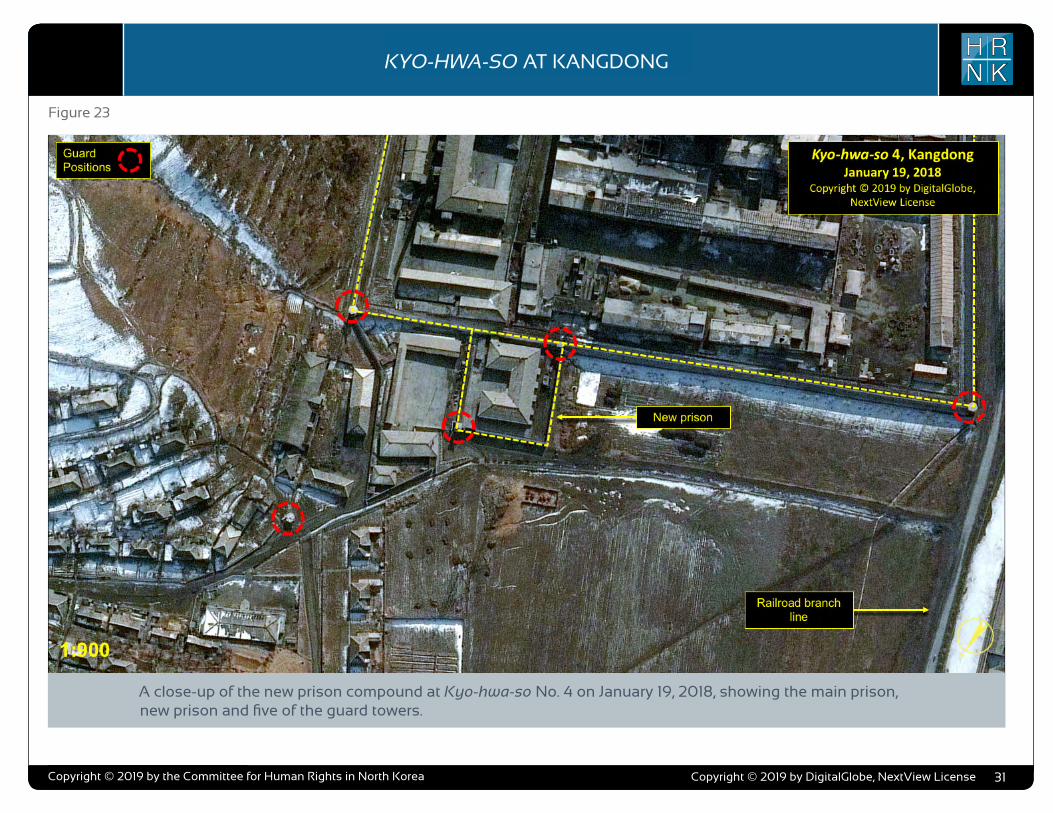
COPYRIGHT ©ALLSOURCE ANALYSIS, INC. 2016 3
H RN K
C H ’ O M A - B O N G R E S T R I C T E D A R E AH RN K
C A M P N O . 2 5
analysis also supports escapee and other reports indicating that Camp No. 25’s primary economic activity is focused on light industry and agriculture. Despite extensive satellite imagery coverage of the camp, AllSource is presently unable to confirm or deny escapee and open-source reports that the camp has a prisoner population of 5,000 people.
As with the analytical caution presented in previous reports (such as North Korea: Imagery Analysis Camp 16 and North Korea: Imagery Analysis of Camp 14 produced by HRNK and AllSource Analysis), it is important to reiterate that North Korean officials, especially those within the Korean People’s Army and the internal security organizations, clearly understand the importance of implementing camouflage, concealment, and deception (CCD) procedures to mask their operations and intentions.3 It would be reasonable to assume that they have done so here.
Location and Organization
Camp No. 25 is under the control of the
3 Bermudez Jr., Joseph S., Dinville, Andy and Eley, Mike. Imagery Analysis of Camp 16, (Washington, D.C.: The Committee for Human Rights in North Korea [HRNK], 2015) available at https://www.hrnk.org/uploads/pdfs/ASA_HRNK_Camp16_v8_full-res_FINAL_12_15_15.pdf and Bermudez Jr., Joseph S. Imagery Analysis: North Korea’s Camp No. 15, Update, (Washington, D.C.: HRNK, 2014) available at http://hrnk.org/uploads/pdfs/Camp%2025%20Update%20Good.pdf.
Prisons Bureau of the State Security Department (SSD), which is under the de facto control of the KWP OGD. Specifically, it is under the control of the SSD's North Hamgyong Provincial Bureau and is located approximately 7.5 km northwestof the port of Ch’ŏng-jin-si in Susŏng-dong, Ch’ŏngjin-si, Hamgyŏng-bukto.4 More specifically, it is
4 It is interesting to note that although the escapee descriptions of this facility’s mission matches that of other kwan-li-so, the physical characteristics ob-served in satellite imagery are more representative of the nation’s kyo-hwa-so, or long-term, felony penitentiaries and prison camps. David Hawk, The Hidden Gulag: Second Edition, Washington, D.C.: Committee for Human Rights in North Korea, 2012, www.hrnk.org/uploads/pdfs/HRNK_HiddenGu-lag2_Web_5-18.pdf. Another sources describes Camp No. 25 this way,
It is not structured as a village but is a fenced facility that looks like an ordinary prison camp [kyo-hwa-so] and is designed for collective living arrangements. The No. 25 [kwan-li-so] houses political prisoners only, while those who committed economic crimes are not allowed into the facility. Some inmates are released upon completion of their term as terms are fixed. Political criminals are detained alone with-out their families. …North Korean defector XXX [sic] testified, “Military personnel are sent off to the Susong kyo-hwa-so [No. 25 kwan-li-so] if their alleged crimes are of a political nature. The Susong kyo-hwa-so [No. 25 kwan-li-so] is for those serving terms of 10 years or longer, but they can return to society once they complete these terms.” It was also testified that the No. 25 kwan-li-so housed senior staff at the Provincial Party, the head of a local MPS office, and other high-ranking officials. North Korean defector XXX [sic] testified that the father of his
located on the south bank of the Sol-gol-ch’ŏn (i.e., Solgol stream) across from the village of Susŏng-dong, to which one foot and two road bridges connect it.
The date of establishment of Camp No. 25 is unclear. One report indicates that the camp was used as a prisoner-of-war camp housing South Korean soldiers at the end of the Korean War.5 This, how-ever, remains to be verified as it may not be referring to the present day camp but rather to an activity in this area. The area in which it is located has been involved in agricultural activities since at least the 1950s. Satellite imagery does indicate that Camp No. 25 was established prior to May 28, 1970, at which time it occupied an irregular shaped area that measured approximately 577 meters by 315 meters (631 yards by 344 yards) and encompassed 13.76 hectares (164,568
friend used to perform the duty of turning over Korean War POWs to South Korea, but he was arrested while attempting to cross the border at the river in Namyang, Onsung County, North Hamgyoung Province. He ended up at the No. 25 kwan-li-so in Chongjin.
Do Kyung-Ok et al., White Paper on Human Rights in North Korea 2015 (Seoul: Korea Institute for National Unification, 2015), p. 122, available at http://www.kinu.or.kr/eng/pub/pub_04_01.jsp.
5 “After the Korean War, it was used as a detention facility for South Korean POWs (Prisoners of War).” Do Kyung-Ok et al., White Paper on Human Rights in North Korea 2015 (Seoul: Korea Institute for National Unification, 2015), p. 122, available at http://www.kinu.or.kr/eng/pub/pub_04_01.jsp.
square yards) and was expanded slightly by January 27, 1976, when it measured approximately 700 meters by 315 meters (765 yards by 344 yards) and encom-passed 15.30 hectares (181,987 square yards) (Figure 1, Figure 2).6
High-resolution satellite imagery from January 18, 2003, through September 21, 2015, indicates that the camp has expanded during this period and that its primary economic activities are centered on agriculture and light industry (Figure 3 through Figure 15).
Several small villages and military facilities are located in the general area around the camp. The camp is connected to the regional electric power grid via overhead high voltage power transmis-sion cables that run from the camp to the substation approximately 1 kilometer to the southeast. It is connected to the national rail network via the station at Susŏng-dong, 800 meters to the east of the facility (Figure 16). The closest air facility to Camp No. 25 is the Korean People’s Air Force’s Sŭngam-ni Air Base, located 18 kilometers south-southwest. This is a training base, and based on its mission, organization, and location, almost certainly provides no support to Camp No. 25.
6 HRNK anticipates that we will be able to further refine the date of the camps establishment in future updates. Referenced imagery includes: KH-4B imagery dated May 28, 1970 and KH-9 (mapping camera) imagery dated January 27, 1976.
North Korea: Imagery Analysis of Camp No. 25 - Update 2
H RN KKYO-HWA-SO AT KANGDONG
Copyright © 2019 by the Committee for Human Rights in North Korea 31
Figure 23
A close-up of the new prison compound at Kyo-hwa-so No. 4 on January 19, 2018, showing the main prison, new prison and five of the guard towers.
Copyright © 2019 by DigitalGlobe, NextView License
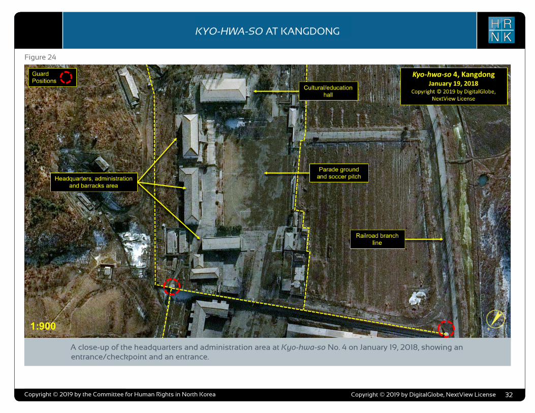
COPYRIGHT ©ALLSOURCE ANALYSIS, INC. 2016 3
H RN K
C H ’ O M A - B O N G R E S T R I C T E D A R E AH RN K
C A M P N O . 2 5
analysis also supports escapee and other reports indicating that Camp No. 25’s primary economic activity is focused on light industry and agriculture. Despite extensive satellite imagery coverage of the camp, AllSource is presently unable to confirm or deny escapee and open-source reports that the camp has a prisoner population of 5,000 people.
As with the analytical caution presented in previous reports (such as North Korea: Imagery Analysis Camp 16 and North Korea: Imagery Analysis of Camp 14 produced by HRNK and AllSource Analysis), it is important to reiterate that North Korean officials, especially those within the Korean People’s Army and the internal security organizations, clearly understand the importance of implementing camouflage, concealment, and deception (CCD) procedures to mask their operations and intentions.3 It would be reasonable to assume that they have done so here.
Location and Organization
Camp No. 25 is under the control of the
3 Bermudez Jr., Joseph S., Dinville, Andy and Eley, Mike. Imagery Analysis of Camp 16, (Washington, D.C.: The Committee for Human Rights in North Korea [HRNK], 2015) available at https://www.hrnk.org/uploads/pdfs/ASA_HRNK_Camp16_v8_full-res_FINAL_12_15_15.pdf and Bermudez Jr., Joseph S. Imagery Analysis: North Korea’s Camp No. 15, Update, (Washington, D.C.: HRNK, 2014) available at http://hrnk.org/uploads/pdfs/Camp%2025%20Update%20Good.pdf.
Prisons Bureau of the State Security Department (SSD), which is under the de facto control of the KWP OGD. Specifically, it is under the control of the SSD's North Hamgyong Provincial Bureau and is located approximately 7.5 km northwestof the port of Ch’ŏng-jin-si in Susŏng-dong, Ch’ŏngjin-si, Hamgyŏng-bukto.4 More specifically, it is
4 It is interesting to note that although the escapee descriptions of this facility’s mission matches that of other kwan-li-so, the physical characteristics ob-served in satellite imagery are more representative of the nation’s kyo-hwa-so, or long-term, felony penitentiaries and prison camps. David Hawk, The Hidden Gulag: Second Edition, Washington, D.C.: Committee for Human Rights in North Korea, 2012, www.hrnk.org/uploads/pdfs/HRNK_HiddenGu-lag2_Web_5-18.pdf. Another sources describes Camp No. 25 this way,
It is not structured as a village but is a fenced facility that looks like an ordinary prison camp [kyo-hwa-so] and is designed for collective living arrangements. The No. 25 [kwan-li-so] houses political prisoners only, while those who committed economic crimes are not allowed into the facility. Some inmates are released upon completion of their term as terms are fixed. Political criminals are detained alone with-out their families. …North Korean defector XXX [sic] testified, “Military personnel are sent off to the Susong kyo-hwa-so [No. 25 kwan-li-so] if their alleged crimes are of a political nature. The Susong kyo-hwa-so [No. 25 kwan-li-so] is for those serving terms of 10 years or longer, but they can return to society once they complete these terms.” It was also testified that the No. 25 kwan-li-so housed senior staff at the Provincial Party, the head of a local MPS office, and other high-ranking officials. North Korean defector XXX [sic] testified that the father of his
located on the south bank of the Sol-gol-ch’ŏn (i.e., Solgol stream) across from the village of Susŏng-dong, to which one foot and two road bridges connect it.
The date of establishment of Camp No. 25 is unclear. One report indicates that the camp was used as a prisoner-of-war camp housing South Korean soldiers at the end of the Korean War.5 This, how-ever, remains to be verified as it may not be referring to the present day camp but rather to an activity in this area. The area in which it is located has been involved in agricultural activities since at least the 1950s. Satellite imagery does indicate that Camp No. 25 was established prior to May 28, 1970, at which time it occupied an irregular shaped area that measured approximately 577 meters by 315 meters (631 yards by 344 yards) and encompassed 13.76 hectares (164,568
friend used to perform the duty of turning over Korean War POWs to South Korea, but he was arrested while attempting to cross the border at the river in Namyang, Onsung County, North Hamgyoung Province. He ended up at the No. 25 kwan-li-so in Chongjin.
Do Kyung-Ok et al., White Paper on Human Rights in North Korea 2015 (Seoul: Korea Institute for National Unification, 2015), p. 122, available at http://www.kinu.or.kr/eng/pub/pub_04_01.jsp.
5 “After the Korean War, it was used as a detention facility for South Korean POWs (Prisoners of War).” Do Kyung-Ok et al., White Paper on Human Rights in North Korea 2015 (Seoul: Korea Institute for National Unification, 2015), p. 122, available at http://www.kinu.or.kr/eng/pub/pub_04_01.jsp.
square yards) and was expanded slightly by January 27, 1976, when it measured approximately 700 meters by 315 meters (765 yards by 344 yards) and encom-passed 15.30 hectares (181,987 square yards) (Figure 1, Figure 2).6
High-resolution satellite imagery from January 18, 2003, through September 21, 2015, indicates that the camp has expanded during this period and that its primary economic activities are centered on agriculture and light industry (Figure 3 through Figure 15).
Several small villages and military facilities are located in the general area around the camp. The camp is connected to the regional electric power grid via overhead high voltage power transmis-sion cables that run from the camp to the substation approximately 1 kilometer to the southeast. It is connected to the national rail network via the station at Susŏng-dong, 800 meters to the east of the facility (Figure 16). The closest air facility to Camp No. 25 is the Korean People’s Air Force’s Sŭngam-ni Air Base, located 18 kilometers south-southwest. This is a training base, and based on its mission, organization, and location, almost certainly provides no support to Camp No. 25.
6 HRNK anticipates that we will be able to further refine the date of the camps establishment in future updates. Referenced imagery includes: KH-4B imagery dated May 28, 1970 and KH-9 (mapping camera) imagery dated January 27, 1976.
North Korea: Imagery Analysis of Camp No. 25 - Update 2
H RN KKYO-HWA-SO AT KANGDONG
Copyright © 2019 by the Committee for Human Rights in North Korea 32
Figure 24
A close-up of the headquarters and administration area at Kyo-hwa-so No. 4 on January 19, 2018, showing an entrance/checkpoint and an entrance.
Copyright © 2019 by DigitalGlobe, NextView License
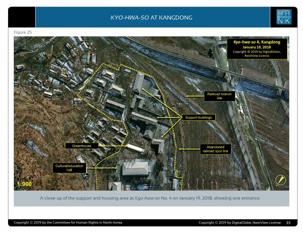
COPYRIGHT ©ALLSOURCE ANALYSIS, INC. 2016 3
H RN K
C H ’ O M A - B O N G R E S T R I C T E D A R E AH RN K
C A M P N O . 2 5
analysis also supports escapee and other reports indicating that Camp No. 25’s primary economic activity is focused on light industry and agriculture. Despite extensive satellite imagery coverage of the camp, AllSource is presently unable to confirm or deny escapee and open-source reports that the camp has a prisoner population of 5,000 people.
As with the analytical caution presented in previous reports (such as North Korea: Imagery Analysis Camp 16 and North Korea: Imagery Analysis of Camp 14 produced by HRNK and AllSource Analysis), it is important to reiterate that North Korean officials, especially those within the Korean People’s Army and the internal security organizations, clearly understand the importance of implementing camouflage, concealment, and deception (CCD) procedures to mask their operations and intentions.3 It would be reasonable to assume that they have done so here.
Location and Organization
Camp No. 25 is under the control of the
3 Bermudez Jr., Joseph S., Dinville, Andy and Eley, Mike. Imagery Analysis of Camp 16, (Washington, D.C.: The Committee for Human Rights in North Korea [HRNK], 2015) available at https://www.hrnk.org/uploads/pdfs/ASA_HRNK_Camp16_v8_full-res_FINAL_12_15_15.pdf and Bermudez Jr., Joseph S. Imagery Analysis: North Korea’s Camp No. 15, Update, (Washington, D.C.: HRNK, 2014) available at http://hrnk.org/uploads/pdfs/Camp%2025%20Update%20Good.pdf.
Prisons Bureau of the State Security Department (SSD), which is under the de facto control of the KWP OGD. Specifically, it is under the control of the SSD's North Hamgyong Provincial Bureau and is located approximately 7.5 km northwestof the port of Ch’ŏng-jin-si in Susŏng-dong, Ch’ŏngjin-si, Hamgyŏng-bukto.4 More specifically, it is
4 It is interesting to note that although the escapee descriptions of this facility’s mission matches that of other kwan-li-so, the physical characteristics ob-served in satellite imagery are more representative of the nation’s kyo-hwa-so, or long-term, felony penitentiaries and prison camps. David Hawk, The Hidden Gulag: Second Edition, Washington, D.C.: Committee for Human Rights in North Korea, 2012, www.hrnk.org/uploads/pdfs/HRNK_HiddenGu-lag2_Web_5-18.pdf. Another sources describes Camp No. 25 this way,
It is not structured as a village but is a fenced facility that looks like an ordinary prison camp [kyo-hwa-so] and is designed for collective living arrangements. The No. 25 [kwan-li-so] houses political prisoners only, while those who committed economic crimes are not allowed into the facility. Some inmates are released upon completion of their term as terms are fixed. Political criminals are detained alone with-out their families. …North Korean defector XXX [sic] testified, “Military personnel are sent off to the Susong kyo-hwa-so [No. 25 kwan-li-so] if their alleged crimes are of a political nature. The Susong kyo-hwa-so [No. 25 kwan-li-so] is for those serving terms of 10 years or longer, but they can return to society once they complete these terms.” It was also testified that the No. 25 kwan-li-so housed senior staff at the Provincial Party, the head of a local MPS office, and other high-ranking officials. North Korean defector XXX [sic] testified that the father of his
located on the south bank of the Sol-gol-ch’ŏn (i.e., Solgol stream) across from the village of Susŏng-dong, to which one foot and two road bridges connect it.
The date of establishment of Camp No. 25 is unclear. One report indicates that the camp was used as a prisoner-of-war camp housing South Korean soldiers at the end of the Korean War.5 This, how-ever, remains to be verified as it may not be referring to the present day camp but rather to an activity in this area. The area in which it is located has been involved in agricultural activities since at least the 1950s. Satellite imagery does indicate that Camp No. 25 was established prior to May 28, 1970, at which time it occupied an irregular shaped area that measured approximately 577 meters by 315 meters (631 yards by 344 yards) and encompassed 13.76 hectares (164,568
friend used to perform the duty of turning over Korean War POWs to South Korea, but he was arrested while attempting to cross the border at the river in Namyang, Onsung County, North Hamgyoung Province. He ended up at the No. 25 kwan-li-so in Chongjin.
Do Kyung-Ok et al., White Paper on Human Rights in North Korea 2015 (Seoul: Korea Institute for National Unification, 2015), p. 122, available at http://www.kinu.or.kr/eng/pub/pub_04_01.jsp.
5 “After the Korean War, it was used as a detention facility for South Korean POWs (Prisoners of War).” Do Kyung-Ok et al., White Paper on Human Rights in North Korea 2015 (Seoul: Korea Institute for National Unification, 2015), p. 122, available at http://www.kinu.or.kr/eng/pub/pub_04_01.jsp.
square yards) and was expanded slightly by January 27, 1976, when it measured approximately 700 meters by 315 meters (765 yards by 344 yards) and encom-passed 15.30 hectares (181,987 square yards) (Figure 1, Figure 2).6
High-resolution satellite imagery from January 18, 2003, through September 21, 2015, indicates that the camp has expanded during this period and that its primary economic activities are centered on agriculture and light industry (Figure 3 through Figure 15).
Several small villages and military facilities are located in the general area around the camp. The camp is connected to the regional electric power grid via overhead high voltage power transmis-sion cables that run from the camp to the substation approximately 1 kilometer to the southeast. It is connected to the national rail network via the station at Susŏng-dong, 800 meters to the east of the facility (Figure 16). The closest air facility to Camp No. 25 is the Korean People’s Air Force’s Sŭngam-ni Air Base, located 18 kilometers south-southwest. This is a training base, and based on its mission, organization, and location, almost certainly provides no support to Camp No. 25.
6 HRNK anticipates that we will be able to further refine the date of the camps establishment in future updates. Referenced imagery includes: KH-4B imagery dated May 28, 1970 and KH-9 (mapping camera) imagery dated January 27, 1976.
North Korea: Imagery Analysis of Camp No. 25 - Update 2
H RN KKYO-HWA-SO AT KANGDONG
Copyright © 2019 by the Committee for Human Rights in North Korea 33
Figure 25
A close-up of the support and housing area at Kyo-hwa-so No. 4 on January 19, 2018, showing one entrance.
Copyright © 2019 by DigitalGlobe, NextView License
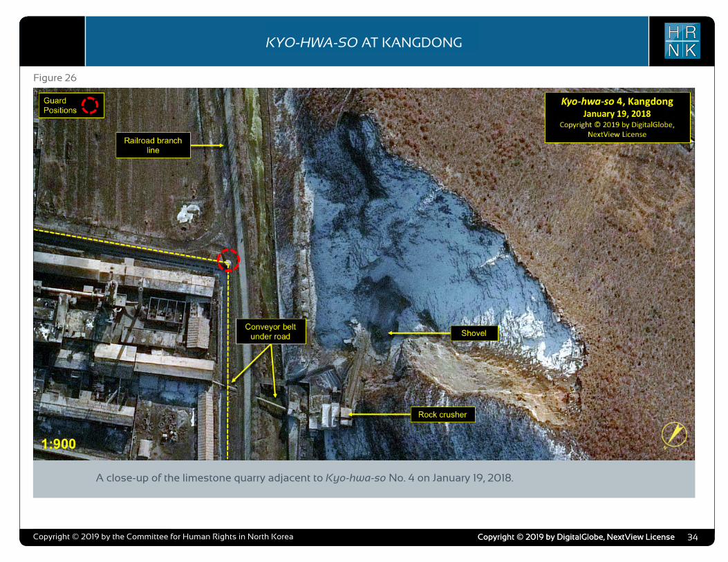
COPYRIGHT ©ALLSOURCE ANALYSIS, INC. 2016 3
H RN K
C H ’ O M A - B O N G R E S T R I C T E D A R E AH RN K
C A M P N O . 2 5
analysis also supports escapee and other reports indicating that Camp No. 25’s primary economic activity is focused on light industry and agriculture. Despite extensive satellite imagery coverage of the camp, AllSource is presently unable to confirm or deny escapee and open-source reports that the camp has a prisoner population of 5,000 people.
As with the analytical caution presented in previous reports (such as North Korea: Imagery Analysis Camp 16 and North Korea: Imagery Analysis of Camp 14 produced by HRNK and AllSource Analysis), it is important to reiterate that North Korean officials, especially those within the Korean People’s Army and the internal security organizations, clearly understand the importance of implementing camouflage, concealment, and deception (CCD) procedures to mask their operations and intentions.3 It would be reasonable to assume that they have done so here.
Location and Organization
Camp No. 25 is under the control of the
3 Bermudez Jr., Joseph S., Dinville, Andy and Eley, Mike. Imagery Analysis of Camp 16, (Washington, D.C.: The Committee for Human Rights in North Korea [HRNK], 2015) available at https://www.hrnk.org/uploads/pdfs/ASA_HRNK_Camp16_v8_full-res_FINAL_12_15_15.pdf and Bermudez Jr., Joseph S. Imagery Analysis: North Korea’s Camp No. 15, Update, (Washington, D.C.: HRNK, 2014) available at http://hrnk.org/uploads/pdfs/Camp%2025%20Update%20Good.pdf.
Prisons Bureau of the State Security Department (SSD), which is under the de facto control of the KWP OGD. Specifically, it is under the control of the SSD's North Hamgyong Provincial Bureau and is located approximately 7.5 km northwestof the port of Ch’ŏng-jin-si in Susŏng-dong, Ch’ŏngjin-si, Hamgyŏng-bukto.4 More specifically, it is
4 It is interesting to note that although the escapee descriptions of this facility’s mission matches that of other kwan-li-so, the physical characteristics ob-served in satellite imagery are more representative of the nation’s kyo-hwa-so, or long-term, felony penitentiaries and prison camps. David Hawk, The Hidden Gulag: Second Edition, Washington, D.C.: Committee for Human Rights in North Korea, 2012, www.hrnk.org/uploads/pdfs/HRNK_HiddenGu-lag2_Web_5-18.pdf. Another sources describes Camp No. 25 this way,
It is not structured as a village but is a fenced facility that looks like an ordinary prison camp [kyo-hwa-so] and is designed for collective living arrangements. The No. 25 [kwan-li-so] houses political prisoners only, while those who committed economic crimes are not allowed into the facility. Some inmates are released upon completion of their term as terms are fixed. Political criminals are detained alone with-out their families. …North Korean defector XXX [sic] testified, “Military personnel are sent off to the Susong kyo-hwa-so [No. 25 kwan-li-so] if their alleged crimes are of a political nature. The Susong kyo-hwa-so [No. 25 kwan-li-so] is for those serving terms of 10 years or longer, but they can return to society once they complete these terms.” It was also testified that the No. 25 kwan-li-so housed senior staff at the Provincial Party, the head of a local MPS office, and other high-ranking officials. North Korean defector XXX [sic] testified that the father of his
located on the south bank of the Sol-gol-ch’ŏn (i.e., Solgol stream) across from the village of Susŏng-dong, to which one foot and two road bridges connect it.
The date of establishment of Camp No. 25 is unclear. One report indicates that the camp was used as a prisoner-of-war camp housing South Korean soldiers at the end of the Korean War.5 This, how-ever, remains to be verified as it may not be referring to the present day camp but rather to an activity in this area. The area in which it is located has been involved in agricultural activities since at least the 1950s. Satellite imagery does indicate that Camp No. 25 was established prior to May 28, 1970, at which time it occupied an irregular shaped area that measured approximately 577 meters by 315 meters (631 yards by 344 yards) and encompassed 13.76 hectares (164,568
friend used to perform the duty of turning over Korean War POWs to South Korea, but he was arrested while attempting to cross the border at the river in Namyang, Onsung County, North Hamgyoung Province. He ended up at the No. 25 kwan-li-so in Chongjin.
Do Kyung-Ok et al., White Paper on Human Rights in North Korea 2015 (Seoul: Korea Institute for National Unification, 2015), p. 122, available at http://www.kinu.or.kr/eng/pub/pub_04_01.jsp.
5 “After the Korean War, it was used as a detention facility for South Korean POWs (Prisoners of War).” Do Kyung-Ok et al., White Paper on Human Rights in North Korea 2015 (Seoul: Korea Institute for National Unification, 2015), p. 122, available at http://www.kinu.or.kr/eng/pub/pub_04_01.jsp.
square yards) and was expanded slightly by January 27, 1976, when it measured approximately 700 meters by 315 meters (765 yards by 344 yards) and encom-passed 15.30 hectares (181,987 square yards) (Figure 1, Figure 2).6
High-resolution satellite imagery from January 18, 2003, through September 21, 2015, indicates that the camp has expanded during this period and that its primary economic activities are centered on agriculture and light industry (Figure 3 through Figure 15).
Several small villages and military facilities are located in the general area around the camp. The camp is connected to the regional electric power grid via overhead high voltage power transmis-sion cables that run from the camp to the substation approximately 1 kilometer to the southeast. It is connected to the national rail network via the station at Susŏng-dong, 800 meters to the east of the facility (Figure 16). The closest air facility to Camp No. 25 is the Korean People’s Air Force’s Sŭngam-ni Air Base, located 18 kilometers south-southwest. This is a training base, and based on its mission, organization, and location, almost certainly provides no support to Camp No. 25.
6 HRNK anticipates that we will be able to further refine the date of the camps establishment in future updates. Referenced imagery includes: KH-4B imagery dated May 28, 1970 and KH-9 (mapping camera) imagery dated January 27, 1976.
North Korea: Imagery Analysis of Camp No. 25 - Update 2
H RN KKYO-HWA-SO AT KANGDONG
Copyright © 2019 by the Committee for Human Rights in North Korea 34
Figure 26
A close-up of the limestone quarry adjacent to Kyo-hwa-so No. 4 on January 19, 2018.
Copyright © 2019 by DigitalGlobe, NextView LicenseCopyright © 2019 by DigitalGlobe, NextView License

COPYRIGHT ©ALLSOURCE ANALYSIS, INC. 2016 3
H RN K
C H ’ O M A - B O N G R E S T R I C T E D A R E AH RN K
C A M P N O . 2 5
analysis also supports escapee and other reports indicating that Camp No. 25’s primary economic activity is focused on light industry and agriculture. Despite extensive satellite imagery coverage of the camp, AllSource is presently unable to confirm or deny escapee and open-source reports that the camp has a prisoner population of 5,000 people.
As with the analytical caution presented in previous reports (such as North Korea: Imagery Analysis Camp 16 and North Korea: Imagery Analysis of Camp 14 produced by HRNK and AllSource Analysis), it is important to reiterate that North Korean officials, especially those within the Korean People’s Army and the internal security organizations, clearly understand the importance of implementing camouflage, concealment, and deception (CCD) procedures to mask their operations and intentions.3 It would be reasonable to assume that they have done so here.
Location and Organization
Camp No. 25 is under the control of the
3 Bermudez Jr., Joseph S., Dinville, Andy and Eley, Mike. Imagery Analysis of Camp 16, (Washington, D.C.: The Committee for Human Rights in North Korea [HRNK], 2015) available at https://www.hrnk.org/uploads/pdfs/ASA_HRNK_Camp16_v8_full-res_FINAL_12_15_15.pdf and Bermudez Jr., Joseph S. Imagery Analysis: North Korea’s Camp No. 15, Update, (Washington, D.C.: HRNK, 2014) available at http://hrnk.org/uploads/pdfs/Camp%2025%20Update%20Good.pdf.
Prisons Bureau of the State Security Department (SSD), which is under the de facto control of the KWP OGD. Specifically, it is under the control of the SSD's North Hamgyong Provincial Bureau and is located approximately 7.5 km northwestof the port of Ch’ŏng-jin-si in Susŏng-dong, Ch’ŏngjin-si, Hamgyŏng-bukto.4 More specifically, it is
4 It is interesting to note that although the escapee descriptions of this facility’s mission matches that of other kwan-li-so, the physical characteristics ob-served in satellite imagery are more representative of the nation’s kyo-hwa-so, or long-term, felony penitentiaries and prison camps. David Hawk, The Hidden Gulag: Second Edition, Washington, D.C.: Committee for Human Rights in North Korea, 2012, www.hrnk.org/uploads/pdfs/HRNK_HiddenGu-lag2_Web_5-18.pdf. Another sources describes Camp No. 25 this way,
It is not structured as a village but is a fenced facility that looks like an ordinary prison camp [kyo-hwa-so] and is designed for collective living arrangements. The No. 25 [kwan-li-so] houses political prisoners only, while those who committed economic crimes are not allowed into the facility. Some inmates are released upon completion of their term as terms are fixed. Political criminals are detained alone with-out their families. …North Korean defector XXX [sic] testified, “Military personnel are sent off to the Susong kyo-hwa-so [No. 25 kwan-li-so] if their alleged crimes are of a political nature. The Susong kyo-hwa-so [No. 25 kwan-li-so] is for those serving terms of 10 years or longer, but they can return to society once they complete these terms.” It was also testified that the No. 25 kwan-li-so housed senior staff at the Provincial Party, the head of a local MPS office, and other high-ranking officials. North Korean defector XXX [sic] testified that the father of his
located on the south bank of the Sol-gol-ch’ŏn (i.e., Solgol stream) across from the village of Susŏng-dong, to which one foot and two road bridges connect it.
The date of establishment of Camp No. 25 is unclear. One report indicates that the camp was used as a prisoner-of-war camp housing South Korean soldiers at the end of the Korean War.5 This, how-ever, remains to be verified as it may not be referring to the present day camp but rather to an activity in this area. The area in which it is located has been involved in agricultural activities since at least the 1950s. Satellite imagery does indicate that Camp No. 25 was established prior to May 28, 1970, at which time it occupied an irregular shaped area that measured approximately 577 meters by 315 meters (631 yards by 344 yards) and encompassed 13.76 hectares (164,568
friend used to perform the duty of turning over Korean War POWs to South Korea, but he was arrested while attempting to cross the border at the river in Namyang, Onsung County, North Hamgyoung Province. He ended up at the No. 25 kwan-li-so in Chongjin.
Do Kyung-Ok et al., White Paper on Human Rights in North Korea 2015 (Seoul: Korea Institute for National Unification, 2015), p. 122, available at http://www.kinu.or.kr/eng/pub/pub_04_01.jsp.
5 “After the Korean War, it was used as a detention facility for South Korean POWs (Prisoners of War).” Do Kyung-Ok et al., White Paper on Human Rights in North Korea 2015 (Seoul: Korea Institute for National Unification, 2015), p. 122, available at http://www.kinu.or.kr/eng/pub/pub_04_01.jsp.
square yards) and was expanded slightly by January 27, 1976, when it measured approximately 700 meters by 315 meters (765 yards by 344 yards) and encom-passed 15.30 hectares (181,987 square yards) (Figure 1, Figure 2).6
High-resolution satellite imagery from January 18, 2003, through September 21, 2015, indicates that the camp has expanded during this period and that its primary economic activities are centered on agriculture and light industry (Figure 3 through Figure 15).
Several small villages and military facilities are located in the general area around the camp. The camp is connected to the regional electric power grid via overhead high voltage power transmis-sion cables that run from the camp to the substation approximately 1 kilometer to the southeast. It is connected to the national rail network via the station at Susŏng-dong, 800 meters to the east of the facility (Figure 16). The closest air facility to Camp No. 25 is the Korean People’s Air Force’s Sŭngam-ni Air Base, located 18 kilometers south-southwest. This is a training base, and based on its mission, organization, and location, almost certainly provides no support to Camp No. 25.
6 HRNK anticipates that we will be able to further refine the date of the camps establishment in future updates. Referenced imagery includes: KH-4B imagery dated May 28, 1970 and KH-9 (mapping camera) imagery dated January 27, 1976.
North Korea: Imagery Analysis of Camp No. 25 - Update 2
H RN KKYO-HWA-SO AT KANGDONG
Copyright © 2019 by the Committee for Human Rights in North Korea 35
Figure 27
A close-up of the headquarters and support area for the limestone quarry adjacent to Kyo-hwa-so No. 4 on January 19, 2018.
Copyright © 2019 by DigitalGlobe, NextView License
COPYRIGHT ©ALLSOURCE ANALYSIS, INC. 2016 3
H RN K
C H ’ O M A - B O N G R E S T R I C T E D A R E AH RN K
C A M P N O . 2 5
analysis also supports escapee and other reports indicating that Camp No. 25’s primary economic activity is focused on light industry and agriculture. Despite extensive satellite imagery coverage of the camp, AllSource is presently unable to confirm or deny escapee and open-source reports that the camp has a prisoner population of 5,000 people.
As with the analytical caution presented in previous reports (such as North Korea: Imagery Analysis Camp 16 and North Korea: Imagery Analysis of Camp 14 produced by HRNK and AllSource Analysis), it is important to reiterate that North Korean officials, especially those within the Korean People’s Army and the internal security organizations, clearly understand the importance of implementing camouflage, concealment, and deception (CCD) procedures to mask their operations and intentions.3 It would be reasonable to assume that they have done so here.
Location and Organization
Camp No. 25 is under the control of the
3 Bermudez Jr., Joseph S., Dinville, Andy and Eley, Mike. Imagery Analysis of Camp 16, (Washington, D.C.: The Committee for Human Rights in North Korea [HRNK], 2015) available at https://www.hrnk.org/uploads/pdfs/ASA_HRNK_Camp16_v8_full-res_FINAL_12_15_15.pdf and Bermudez Jr., Joseph S. Imagery Analysis: North Korea’s Camp No. 15, Update, (Washington, D.C.: HRNK, 2014) available at http://hrnk.org/uploads/pdfs/Camp%2025%20Update%20Good.pdf.
Prisons Bureau of the State Security Department (SSD), which is under the de facto control of the KWP OGD. Specifically, it is under the control of the SSD's North Hamgyong Provincial Bureau and is located approximately 7.5 km northwestof the port of Ch’ŏng-jin-si in Susŏng-dong, Ch’ŏngjin-si, Hamgyŏng-bukto.4 More specifically, it is
4 It is interesting to note that although the escapee descriptions of this facility’s mission matches that of other kwan-li-so, the physical characteristics ob-served in satellite imagery are more representative of the nation’s kyo-hwa-so, or long-term, felony penitentiaries and prison camps. David Hawk, The Hidden Gulag: Second Edition, Washington, D.C.: Committee for Human Rights in North Korea, 2012, www.hrnk.org/uploads/pdfs/HRNK_HiddenGu-lag2_Web_5-18.pdf. Another sources describes Camp No. 25 this way,
It is not structured as a village but is a fenced facility that looks like an ordinary prison camp [kyo-hwa-so] and is designed for collective living arrangements. The No. 25 [kwan-li-so] houses political prisoners only, while those who committed economic crimes are not allowed into the facility. Some inmates are released upon completion of their term as terms are fixed. Political criminals are detained alone with-out their families. …North Korean defector XXX [sic] testified, “Military personnel are sent off to the Susong kyo-hwa-so [No. 25 kwan-li-so] if their alleged crimes are of a political nature. The Susong kyo-hwa-so [No. 25 kwan-li-so] is for those serving terms of 10 years or longer, but they can return to society once they complete these terms.” It was also testified that the No. 25 kwan-li-so housed senior staff at the Provincial Party, the head of a local MPS office, and other high-ranking officials. North Korean defector XXX [sic] testified that the father of his
located on the south bank of the Sol-gol-ch’ŏn (i.e., Solgol stream) across from the village of Susŏng-dong, to which one foot and two road bridges connect it.
The date of establishment of Camp No. 25 is unclear. One report indicates that the camp was used as a prisoner-of-war camp housing South Korean soldiers at the end of the Korean War.5 This, how-ever, remains to be verified as it may not be referring to the present day camp but rather to an activity in this area. The area in which it is located has been involved in agricultural activities since at least the 1950s. Satellite imagery does indicate that Camp No. 25 was established prior to May 28, 1970, at which time it occupied an irregular shaped area that measured approximately 577 meters by 315 meters (631 yards by 344 yards) and encompassed 13.76 hectares (164,568
friend used to perform the duty of turning over Korean War POWs to South Korea, but he was arrested while attempting to cross the border at the river in Namyang, Onsung County, North Hamgyoung Province. He ended up at the No. 25 kwan-li-so in Chongjin.
Do Kyung-Ok et al., White Paper on Human Rights in North Korea 2015 (Seoul: Korea Institute for National Unification, 2015), p. 122, available at http://www.kinu.or.kr/eng/pub/pub_04_01.jsp.
5 “After the Korean War, it was used as a detention facility for South Korean POWs (Prisoners of War).” Do Kyung-Ok et al., White Paper on Human Rights in North Korea 2015 (Seoul: Korea Institute for National Unification, 2015), p. 122, available at http://www.kinu.or.kr/eng/pub/pub_04_01.jsp.
square yards) and was expanded slightly by January 27, 1976, when it measured approximately 700 meters by 315 meters (765 yards by 344 yards) and encom-passed 15.30 hectares (181,987 square yards) (Figure 1, Figure 2).6
High-resolution satellite imagery from January 18, 2003, through September 21, 2015, indicates that the camp has expanded during this period and that its primary economic activities are centered on agriculture and light industry (Figure 3 through Figure 15).
Several small villages and military facilities are located in the general area around the camp. The camp is connected to the regional electric power grid via overhead high voltage power transmis-sion cables that run from the camp to the substation approximately 1 kilometer to the southeast. It is connected to the national rail network via the station at Susŏng-dong, 800 meters to the east of the facility (Figure 16). The closest air facility to Camp No. 25 is the Korean People’s Air Force’s Sŭngam-ni Air Base, located 18 kilometers south-southwest. This is a training base, and based on its mission, organization, and location, almost certainly provides no support to Camp No. 25.
6 HRNK anticipates that we will be able to further refine the date of the camps establishment in future updates. Referenced imagery includes: KH-4B imagery dated May 28, 1970 and KH-9 (mapping camera) imagery dated January 27, 1976.
North Korea: Imagery Analysis of Camp No. 25 - Update 2
H RN KKYO-HWA-SO AT KANGDONG
Copyright © 2019 by the Committee for Human Rights in North Korea 36
Additional Activities
Within one kilometer of Kyo-hwa-so No. 4 there are at least four tra-ditional burial grounds. However, no linkage has been established between these and the prison. If Kyo-hwa-so No. 4 follows known practices at other North Korean detention facilities it is unlikely that these burial grounds are used by the prison.
There is only one military base (likely for reserve forces) and no air defense artillery sites ob-served within five kilometers of the prison. It is unlikely that the military base provides any sup-port to the prison. The closest air facility to Kyo-hwa-so No. 4 is the Korean People’s Air Force’s Kangdong Airbase located 17.5 kilometers northwest. This is an operational training base, and due to its mission, organization, and location almost certainly provides no support to Kyo-hwa-so No. 4.
While the prison is likely con-nected to the regional telephone network, it is likely via buried ser-vice as no evidence of overhead service was identified in satellite imagery. Two runs of high-volt-age power lines pass directly by the prison, and it is likely that the facility receives its electricity from one of these grids. An unused railroad branch line passes im-mediately adjacent to the prison’s west wall and there is an aban-doned rail spur leading into the headquarters area. The prison is connected to the national rail network via the station at Saegŏl, two kilometers to the east.
Assessment
Analysis of high-resolution sat-ellite imagery of Kyo-hwa-so No. 4 and its environs collected between September 2004 and December 2017 indicate that,
» Kyo-hwa-so No. 4 is an op-erational prison facility that
has been operational since at least 1965
» It is, by DPRK standards, a very mature and well-main-tained prison facility
» There have been no signifi-cant changes to the physi-cal size, including prisoner housing structures, of the facility since the end of 2014.
» Perimeter walls and check-points/entrances are well maintained and in good repair.
» Guard positions are well positioned to provide over-lapping fields-of-view of the prison and are well main-tained and in good repair
» Administrative, barracks, housing, support buildings, and grounds are well main-tained and in good repair
» The grounds and buildings for prisoner housing appear to be well maintained and in a good state of repair
» Prisoner population likely expanded slightly following
the addition of a new prison compound during 2014.
» The layout and location of the new prison suggests a different class of prisoners are been detained than those in the main prison.
» The primary activity of the prisoners at the prison appears to be the operation of the prison’s limestone production plant.
» Given North Korea’s gener-ally poor implementation of industrial worker safety and health policies it is likely that the prisoners oper-ating the limestone plant are subject to even worse conditions.
» In some of the available imagery the stream running adjacent to the prison has a yellowish-green color. While this may be related to algae blooms it could also be a result of pollution from facilities further upstream. If the latter, it would represent
NORTH KOREA’S LONG-TERM PRISON-LABOR FACILITY (KYO-HWA-SO) AT KANGDONG

COPYRIGHT ©ALLSOURCE ANALYSIS, INC. 2016 3
H RN K
C H ’ O M A - B O N G R E S T R I C T E D A R E AH RN K
C A M P N O . 2 5
analysis also supports escapee and other reports indicating that Camp No. 25’s primary economic activity is focused on light industry and agriculture. Despite extensive satellite imagery coverage of the camp, AllSource is presently unable to confirm or deny escapee and open-source reports that the camp has a prisoner population of 5,000 people.
As with the analytical caution presented in previous reports (such as North Korea: Imagery Analysis Camp 16 and North Korea: Imagery Analysis of Camp 14 produced by HRNK and AllSource Analysis), it is important to reiterate that North Korean officials, especially those within the Korean People’s Army and the internal security organizations, clearly understand the importance of implementing camouflage, concealment, and deception (CCD) procedures to mask their operations and intentions.3 It would be reasonable to assume that they have done so here.
Location and Organization
Camp No. 25 is under the control of the
3 Bermudez Jr., Joseph S., Dinville, Andy and Eley, Mike. Imagery Analysis of Camp 16, (Washington, D.C.: The Committee for Human Rights in North Korea [HRNK], 2015) available at https://www.hrnk.org/uploads/pdfs/ASA_HRNK_Camp16_v8_full-res_FINAL_12_15_15.pdf and Bermudez Jr., Joseph S. Imagery Analysis: North Korea’s Camp No. 15, Update, (Washington, D.C.: HRNK, 2014) available at http://hrnk.org/uploads/pdfs/Camp%2025%20Update%20Good.pdf.
Prisons Bureau of the State Security Department (SSD), which is under the de facto control of the KWP OGD. Specifically, it is under the control of the SSD's North Hamgyong Provincial Bureau and is located approximately 7.5 km northwestof the port of Ch’ŏng-jin-si in Susŏng-dong, Ch’ŏngjin-si, Hamgyŏng-bukto.4 More specifically, it is
4 It is interesting to note that although the escapee descriptions of this facility’s mission matches that of other kwan-li-so, the physical characteristics ob-served in satellite imagery are more representative of the nation’s kyo-hwa-so, or long-term, felony penitentiaries and prison camps. David Hawk, The Hidden Gulag: Second Edition, Washington, D.C.: Committee for Human Rights in North Korea, 2012, www.hrnk.org/uploads/pdfs/HRNK_HiddenGu-lag2_Web_5-18.pdf. Another sources describes Camp No. 25 this way,
It is not structured as a village but is a fenced facility that looks like an ordinary prison camp [kyo-hwa-so] and is designed for collective living arrangements. The No. 25 [kwan-li-so] houses political prisoners only, while those who committed economic crimes are not allowed into the facility. Some inmates are released upon completion of their term as terms are fixed. Political criminals are detained alone with-out their families. …North Korean defector XXX [sic] testified, “Military personnel are sent off to the Susong kyo-hwa-so [No. 25 kwan-li-so] if their alleged crimes are of a political nature. The Susong kyo-hwa-so [No. 25 kwan-li-so] is for those serving terms of 10 years or longer, but they can return to society once they complete these terms.” It was also testified that the No. 25 kwan-li-so housed senior staff at the Provincial Party, the head of a local MPS office, and other high-ranking officials. North Korean defector XXX [sic] testified that the father of his
located on the south bank of the Sol-gol-ch’ŏn (i.e., Solgol stream) across from the village of Susŏng-dong, to which one foot and two road bridges connect it.
The date of establishment of Camp No. 25 is unclear. One report indicates that the camp was used as a prisoner-of-war camp housing South Korean soldiers at the end of the Korean War.5 This, how-ever, remains to be verified as it may not be referring to the present day camp but rather to an activity in this area. The area in which it is located has been involved in agricultural activities since at least the 1950s. Satellite imagery does indicate that Camp No. 25 was established prior to May 28, 1970, at which time it occupied an irregular shaped area that measured approximately 577 meters by 315 meters (631 yards by 344 yards) and encompassed 13.76 hectares (164,568
friend used to perform the duty of turning over Korean War POWs to South Korea, but he was arrested while attempting to cross the border at the river in Namyang, Onsung County, North Hamgyoung Province. He ended up at the No. 25 kwan-li-so in Chongjin.
Do Kyung-Ok et al., White Paper on Human Rights in North Korea 2015 (Seoul: Korea Institute for National Unification, 2015), p. 122, available at http://www.kinu.or.kr/eng/pub/pub_04_01.jsp.
5 “After the Korean War, it was used as a detention facility for South Korean POWs (Prisoners of War).” Do Kyung-Ok et al., White Paper on Human Rights in North Korea 2015 (Seoul: Korea Institute for National Unification, 2015), p. 122, available at http://www.kinu.or.kr/eng/pub/pub_04_01.jsp.
square yards) and was expanded slightly by January 27, 1976, when it measured approximately 700 meters by 315 meters (765 yards by 344 yards) and encom-passed 15.30 hectares (181,987 square yards) (Figure 1, Figure 2).6
High-resolution satellite imagery from January 18, 2003, through September 21, 2015, indicates that the camp has expanded during this period and that its primary economic activities are centered on agriculture and light industry (Figure 3 through Figure 15).
Several small villages and military facilities are located in the general area around the camp. The camp is connected to the regional electric power grid via overhead high voltage power transmis-sion cables that run from the camp to the substation approximately 1 kilometer to the southeast. It is connected to the national rail network via the station at Susŏng-dong, 800 meters to the east of the facility (Figure 16). The closest air facility to Camp No. 25 is the Korean People’s Air Force’s Sŭngam-ni Air Base, located 18 kilometers south-southwest. This is a training base, and based on its mission, organization, and location, almost certainly provides no support to Camp No. 25.
6 HRNK anticipates that we will be able to further refine the date of the camps establishment in future updates. Referenced imagery includes: KH-4B imagery dated May 28, 1970 and KH-9 (mapping camera) imagery dated January 27, 1976.
North Korea: Imagery Analysis of Camp No. 25 - Update 2
H RN KKYO-HWA-SO AT KANGDONG
Copyright © 2019 by the Committee for Human Rights in North Korea 37
an additional health risk to those detained at the prison.
» Given the proximity of the prison to both numerous small coal mining operations and the construction site for the Kangdong Thermal Power Plant , it would not be unusual for prison labor to be used at these activities.
As noted above, despite extensive satellite imagery coverage of the area, it is presently not possible to arrive at an accurate estimate of the prisoner population at Kyo-hwa-so No. 4.
Recommendations
Continued background investiga-tion and ongoing monitoring of Kyo-hwa-so No. 4 is recommend-ed to provide a more detailed ac-counting of its previous operations and develop an objective baseline understanding of its continuing activities, maintain an evidentiary catalog of physical changes at the
facility, update its status, develop evidence of prisoner population size, assess the health of prison-ers as a result of prolonged expo-sure to limestone dust, and assist with the identification of possible human rights abuses.
Note
HRNK would like to extend a special note of thanks to sever-al individuals for their gracious assistance in preparing this report. Ishimaru Jiro (Asia Press) for generously sharing ground imagery of Kyo-hwa-so No. 4 that was covertly acquired in 2009. Bobby Holt for taking the time to review the draft of this report and for providing extensive comments based upon his years of experience. Allen Anderson for his gracious support of HRNK’s efforts to document North Korea’s political prison system and the tragic conditions present within that system.
NORTH KOREA’S LONG-TERM PRISON-LABOR FACILITY (KYO-HWA-SO) AT KANGDONG
Gazetteer
Location Latitude (N) Longitude (E)
Kyo-hwa-so No. 4 39.008838° 126.153277°
Kangdong 39.141855° 126.099001°
Kangdong Thermal Power Plant Construction Site
39.001541° 126.162211°
Saegol Rail Station 39.011572° 126.177113°

COPYRIGHT ©ALLSOURCE ANALYSIS, INC. 2016 3
H RN K
C H ’ O M A - B O N G R E S T R I C T E D A R E AH RN K
C A M P N O . 2 5
analysis also supports escapee and other reports indicating that Camp No. 25’s primary economic activity is focused on light industry and agriculture. Despite extensive satellite imagery coverage of the camp, AllSource is presently unable to confirm or deny escapee and open-source reports that the camp has a prisoner population of 5,000 people.
As with the analytical caution presented in previous reports (such as North Korea: Imagery Analysis Camp 16 and North Korea: Imagery Analysis of Camp 14 produced by HRNK and AllSource Analysis), it is important to reiterate that North Korean officials, especially those within the Korean People’s Army and the internal security organizations, clearly understand the importance of implementing camouflage, concealment, and deception (CCD) procedures to mask their operations and intentions.3 It would be reasonable to assume that they have done so here.
Location and Organization
Camp No. 25 is under the control of the
3 Bermudez Jr., Joseph S., Dinville, Andy and Eley, Mike. Imagery Analysis of Camp 16, (Washington, D.C.: The Committee for Human Rights in North Korea [HRNK], 2015) available at https://www.hrnk.org/uploads/pdfs/ASA_HRNK_Camp16_v8_full-res_FINAL_12_15_15.pdf and Bermudez Jr., Joseph S. Imagery Analysis: North Korea’s Camp No. 15, Update, (Washington, D.C.: HRNK, 2014) available at http://hrnk.org/uploads/pdfs/Camp%2025%20Update%20Good.pdf.
Prisons Bureau of the State Security Department (SSD), which is under the de facto control of the KWP OGD. Specifically, it is under the control of the SSD's North Hamgyong Provincial Bureau and is located approximately 7.5 km northwestof the port of Ch’ŏng-jin-si in Susŏng-dong, Ch’ŏngjin-si, Hamgyŏng-bukto.4 More specifically, it is
4 It is interesting to note that although the escapee descriptions of this facility’s mission matches that of other kwan-li-so, the physical characteristics ob-served in satellite imagery are more representative of the nation’s kyo-hwa-so, or long-term, felony penitentiaries and prison camps. David Hawk, The Hidden Gulag: Second Edition, Washington, D.C.: Committee for Human Rights in North Korea, 2012, www.hrnk.org/uploads/pdfs/HRNK_HiddenGu-lag2_Web_5-18.pdf. Another sources describes Camp No. 25 this way,
It is not structured as a village but is a fenced facility that looks like an ordinary prison camp [kyo-hwa-so] and is designed for collective living arrangements. The No. 25 [kwan-li-so] houses political prisoners only, while those who committed economic crimes are not allowed into the facility. Some inmates are released upon completion of their term as terms are fixed. Political criminals are detained alone with-out their families. …North Korean defector XXX [sic] testified, “Military personnel are sent off to the Susong kyo-hwa-so [No. 25 kwan-li-so] if their alleged crimes are of a political nature. The Susong kyo-hwa-so [No. 25 kwan-li-so] is for those serving terms of 10 years or longer, but they can return to society once they complete these terms.” It was also testified that the No. 25 kwan-li-so housed senior staff at the Provincial Party, the head of a local MPS office, and other high-ranking officials. North Korean defector XXX [sic] testified that the father of his
located on the south bank of the Sol-gol-ch’ŏn (i.e., Solgol stream) across from the village of Susŏng-dong, to which one foot and two road bridges connect it.
The date of establishment of Camp No. 25 is unclear. One report indicates that the camp was used as a prisoner-of-war camp housing South Korean soldiers at the end of the Korean War.5 This, how-ever, remains to be verified as it may not be referring to the present day camp but rather to an activity in this area. The area in which it is located has been involved in agricultural activities since at least the 1950s. Satellite imagery does indicate that Camp No. 25 was established prior to May 28, 1970, at which time it occupied an irregular shaped area that measured approximately 577 meters by 315 meters (631 yards by 344 yards) and encompassed 13.76 hectares (164,568
friend used to perform the duty of turning over Korean War POWs to South Korea, but he was arrested while attempting to cross the border at the river in Namyang, Onsung County, North Hamgyoung Province. He ended up at the No. 25 kwan-li-so in Chongjin.
Do Kyung-Ok et al., White Paper on Human Rights in North Korea 2015 (Seoul: Korea Institute for National Unification, 2015), p. 122, available at http://www.kinu.or.kr/eng/pub/pub_04_01.jsp.
5 “After the Korean War, it was used as a detention facility for South Korean POWs (Prisoners of War).” Do Kyung-Ok et al., White Paper on Human Rights in North Korea 2015 (Seoul: Korea Institute for National Unification, 2015), p. 122, available at http://www.kinu.or.kr/eng/pub/pub_04_01.jsp.
square yards) and was expanded slightly by January 27, 1976, when it measured approximately 700 meters by 315 meters (765 yards by 344 yards) and encom-passed 15.30 hectares (181,987 square yards) (Figure 1, Figure 2).6
High-resolution satellite imagery from January 18, 2003, through September 21, 2015, indicates that the camp has expanded during this period and that its primary economic activities are centered on agriculture and light industry (Figure 3 through Figure 15).
Several small villages and military facilities are located in the general area around the camp. The camp is connected to the regional electric power grid via overhead high voltage power transmis-sion cables that run from the camp to the substation approximately 1 kilometer to the southeast. It is connected to the national rail network via the station at Susŏng-dong, 800 meters to the east of the facility (Figure 16). The closest air facility to Camp No. 25 is the Korean People’s Air Force’s Sŭngam-ni Air Base, located 18 kilometers south-southwest. This is a training base, and based on its mission, organization, and location, almost certainly provides no support to Camp No. 25.
6 HRNK anticipates that we will be able to further refine the date of the camps establishment in future updates. Referenced imagery includes: KH-4B imagery dated May 28, 1970 and KH-9 (mapping camera) imagery dated January 27, 1976.
North Korea: Imagery Analysis of Camp No. 25 - Update 2
H RN KKYO-HWA-SO AT KANGDONG
Copyright © 2019 by the Committee for Human Rights in North Korea 38
Endnotes
1. UN Human Rights Council, Report of the detailed findings of the commission of inquiry, para. 1033.
2. Robert Collins and Amanda Mortwedt Oh, From Cradle to Grave: The Path of North Korean Innocents, (Washington, D.C.: Committee for Human Rights in North Korea, 2017), available at https://www.hrnk.org/uploads/pdfs/Collins_Cradle_to_Grave_WEB_FINALFINAL.pdf.
3. UN Human Rights Council, Report of the detailed findings of the commission of inquiry, para. 1220(b).
4. HRNK has published fifteen prison camp reports over the last five years as part of an ongoing effort to monitor the prison camps. These reports are available at https://www.hrnk.org/publications/hrnk-publications.php?page=3.
5. David Hawk with Amanda Mortwedt Oh, The Parallel Gulag: North Korea’s ‘An-jeon-bu’ Prison Camps, (Washington, D.C.: Committee for Human Rights in North Korea, 2017), available at https://www.hrnk.org/uploads/pdfs/Hawk_The_Parallel_Gulag_Web.pdf.
6. This information comes from open source documents and commercial satellite imagery.
7. Previous reports in the project can be found at https://www.hrnk.org/publications/hrnk-publications.php.
8. Escapees and researchers indicate that the title “Kyo-hwa-so No. 4, Kangdong” may represent an umbrella organization that has several subordinate facilities including the one identified in this report. The U.S. National Geospatial Intelligence Agency identifies the specific location of the prison in this report is at Chaek-kol. White Paper
on Human Rights in North Korea, 2016 (Seoul, Korea: Korea Institute for National Unification, 2016), available at http://repo.kinu.or.kr/handle/2015.oak/7968. Asia Press refers to the facility as Samdung Kyo-hwa-so (삼등 교화소).
9. The term “high resolution” in this report refers to satellite images with a ground sample distance (GSD) of less than 1.2 meters. The GSD is the distance between pixel centers when measured on the ground. The only known ground imagery of Kyo-hwa-so No. 4 was first seen publicly in 2017. Ishimaru Jiro, “Death Is Common: Horrific North Korean Prisons Beyond Description,” Asia Press, December 21, 2017, http://www.asiapress.org/rimjin-gang/report/horrific-north-korean-prison/.
10. Limestone is crucial component in the production of cement, and concrete. Significantly, it is also one of a few ingredients necessary to remove impurities in
manufacture of pig iron which is then used to produce cast iron for beams in constructing buildings and bridges or for making steel.
11. Joseph S. Bermudez Jr., Andy Dinville, and Mike Eley, Imagery Analysis of Camp 16, (Washington, D.C.: Committee for Human Rights in North Korea, 2015) available at https://www.hrnk.org/uploads/pdfs/ASA_HRNK_Camp16_v8_fullres_FINAL_12_15_15.pdf and Joseph S.B ermudez Jr., Imagery Analysis: North Korea’s Camp No. 15, Update (Washington, D.C.: Committee for Human Rights in North Korea, 2014), available at http://hrnk.org/uploads/pdfs/Camp%2025%20Update%20Good.pdf.
12. White Paper on Human Rights in North Korea, 2016 (Seoul, Korea: Korea Institute for National Unification, July 2016), available at http://repo.kinu.or.kr/handle/2015.oak/7968.
NORTH KOREA’S LONG-TERM PRISON-LABOR FACILITY (KYO-HWA-SO) AT KANGDONG

COPYRIGHT ©ALLSOURCE ANALYSIS, INC. 2016 3
H RN K
C H ’ O M A - B O N G R E S T R I C T E D A R E AH RN K
C A M P N O . 2 5
analysis also supports escapee and other reports indicating that Camp No. 25’s primary economic activity is focused on light industry and agriculture. Despite extensive satellite imagery coverage of the camp, AllSource is presently unable to confirm or deny escapee and open-source reports that the camp has a prisoner population of 5,000 people.
As with the analytical caution presented in previous reports (such as North Korea: Imagery Analysis Camp 16 and North Korea: Imagery Analysis of Camp 14 produced by HRNK and AllSource Analysis), it is important to reiterate that North Korean officials, especially those within the Korean People’s Army and the internal security organizations, clearly understand the importance of implementing camouflage, concealment, and deception (CCD) procedures to mask their operations and intentions.3 It would be reasonable to assume that they have done so here.
Location and Organization
Camp No. 25 is under the control of the
3 Bermudez Jr., Joseph S., Dinville, Andy and Eley, Mike. Imagery Analysis of Camp 16, (Washington, D.C.: The Committee for Human Rights in North Korea [HRNK], 2015) available at https://www.hrnk.org/uploads/pdfs/ASA_HRNK_Camp16_v8_full-res_FINAL_12_15_15.pdf and Bermudez Jr., Joseph S. Imagery Analysis: North Korea’s Camp No. 15, Update, (Washington, D.C.: HRNK, 2014) available at http://hrnk.org/uploads/pdfs/Camp%2025%20Update%20Good.pdf.
Prisons Bureau of the State Security Department (SSD), which is under the de facto control of the KWP OGD. Specifically, it is under the control of the SSD's North Hamgyong Provincial Bureau and is located approximately 7.5 km northwestof the port of Ch’ŏng-jin-si in Susŏng-dong, Ch’ŏngjin-si, Hamgyŏng-bukto.4 More specifically, it is
4 It is interesting to note that although the escapee descriptions of this facility’s mission matches that of other kwan-li-so, the physical characteristics ob-served in satellite imagery are more representative of the nation’s kyo-hwa-so, or long-term, felony penitentiaries and prison camps. David Hawk, The Hidden Gulag: Second Edition, Washington, D.C.: Committee for Human Rights in North Korea, 2012, www.hrnk.org/uploads/pdfs/HRNK_HiddenGu-lag2_Web_5-18.pdf. Another sources describes Camp No. 25 this way,
It is not structured as a village but is a fenced facility that looks like an ordinary prison camp [kyo-hwa-so] and is designed for collective living arrangements. The No. 25 [kwan-li-so] houses political prisoners only, while those who committed economic crimes are not allowed into the facility. Some inmates are released upon completion of their term as terms are fixed. Political criminals are detained alone with-out their families. …North Korean defector XXX [sic] testified, “Military personnel are sent off to the Susong kyo-hwa-so [No. 25 kwan-li-so] if their alleged crimes are of a political nature. The Susong kyo-hwa-so [No. 25 kwan-li-so] is for those serving terms of 10 years or longer, but they can return to society once they complete these terms.” It was also testified that the No. 25 kwan-li-so housed senior staff at the Provincial Party, the head of a local MPS office, and other high-ranking officials. North Korean defector XXX [sic] testified that the father of his
located on the south bank of the Sol-gol-ch’ŏn (i.e., Solgol stream) across from the village of Susŏng-dong, to which one foot and two road bridges connect it.
The date of establishment of Camp No. 25 is unclear. One report indicates that the camp was used as a prisoner-of-war camp housing South Korean soldiers at the end of the Korean War.5 This, how-ever, remains to be verified as it may not be referring to the present day camp but rather to an activity in this area. The area in which it is located has been involved in agricultural activities since at least the 1950s. Satellite imagery does indicate that Camp No. 25 was established prior to May 28, 1970, at which time it occupied an irregular shaped area that measured approximately 577 meters by 315 meters (631 yards by 344 yards) and encompassed 13.76 hectares (164,568
friend used to perform the duty of turning over Korean War POWs to South Korea, but he was arrested while attempting to cross the border at the river in Namyang, Onsung County, North Hamgyoung Province. He ended up at the No. 25 kwan-li-so in Chongjin.
Do Kyung-Ok et al., White Paper on Human Rights in North Korea 2015 (Seoul: Korea Institute for National Unification, 2015), p. 122, available at http://www.kinu.or.kr/eng/pub/pub_04_01.jsp.
5 “After the Korean War, it was used as a detention facility for South Korean POWs (Prisoners of War).” Do Kyung-Ok et al., White Paper on Human Rights in North Korea 2015 (Seoul: Korea Institute for National Unification, 2015), p. 122, available at http://www.kinu.or.kr/eng/pub/pub_04_01.jsp.
square yards) and was expanded slightly by January 27, 1976, when it measured approximately 700 meters by 315 meters (765 yards by 344 yards) and encom-passed 15.30 hectares (181,987 square yards) (Figure 1, Figure 2).6
High-resolution satellite imagery from January 18, 2003, through September 21, 2015, indicates that the camp has expanded during this period and that its primary economic activities are centered on agriculture and light industry (Figure 3 through Figure 15).
Several small villages and military facilities are located in the general area around the camp. The camp is connected to the regional electric power grid via overhead high voltage power transmis-sion cables that run from the camp to the substation approximately 1 kilometer to the southeast. It is connected to the national rail network via the station at Susŏng-dong, 800 meters to the east of the facility (Figure 16). The closest air facility to Camp No. 25 is the Korean People’s Air Force’s Sŭngam-ni Air Base, located 18 kilometers south-southwest. This is a training base, and based on its mission, organization, and location, almost certainly provides no support to Camp No. 25.
6 HRNK anticipates that we will be able to further refine the date of the camps establishment in future updates. Referenced imagery includes: KH-4B imagery dated May 28, 1970 and KH-9 (mapping camera) imagery dated January 27, 1976.
North Korea: Imagery Analysis of Camp No. 25 - Update 2
H RN KKYO-HWA-SO AT KANGDONG
Copyright © 2019 by the Committee for Human Rights in North Korea 39
13. HRNK anticipates that we will be able to further refine the date of Kyo-hwa-so No. 4’s establishment in future updates when additional declassified satellite imagery from the 1960s is examined.
14. The following sources were used throughout this section: Political Prison Camps in North Korea Today (Seoul, Korea: Database Center for North Korean Human Rights, 20), available at http://nkdb.org/2012/main.php; David Hawk, The Hidden Gulag: Second Edition (Washington, D.C.: Committee for Human Rights in North Korea, 2012), 3, 63, 79, and 223, available at http://www.hrnk.org/uploads/pdfs/HRNK_HiddenGulag2_Web_5-18.pdf; David Hawk, The Hidden Gulag: Third
Edition (Washington, D.C.: Committee for Human Rights in North Korea, 2013), 22 and 25, available at http://www.hrnk.org/uploads/pdfs/NKHiddenGulag_DavidHawk(2).pdf; David Hawk, The Hidden Gulag: Fourth Edition (Washington, D.C.: Committee for Human Rights in North Korea, 2015), 8, available at http://www.hrnk.org/uploads/pdfs/Hawk_HiddenGulag4_FINAL.pdf; Soo-am Kim, Kook-shin Kim, Soon-hee Lim, et al., White Paper on Human Rights in North Korea, 2003–2013, (Seoul, Korea: Korea Institute for National Unification, 2003-2013), available at http://www.kinu.or.kr/eng/pub/pub_04_01.jsp; White Paper on Human Rights in North Korea, 2014, (Seoul, Korea: Korea Institute for National Unification, 2014), 180-
81, 189, 194, and 624, available at: www.kinu.or.kr/eng/pub/; White Paper on Human Rights in North Korea, 2015 (Seoul, Korea: Korea Institute for National Unification, 2015), 115-116, 122, 126, and 517, available at: www.kinu.or.kr/eng/pub/; and Report of the Commission of Inquiry on Human Rights in the Democratic People’s Republic of Korea, A/HRC/25/CRP.1, UN Human Rights Council, 7 February 2014, 222-224, 263, available at http://www.ohchr.org/Documents/HRBodies/HRCouncil/CoIDPRK/Report/A.HRC.25.CRP.1_ENG.doc.
15. Ground imagery of the prison shows a similarity between the
NORTH KOREA’S LONG-TERM PRISON-LABOR FACILITY (KYO-HWA-SO) AT KANGDONG
prison’s walls to those erected by the Japanese during the colonial period. For example, see: McNally, David.
“Yongsan Garrison: If walls could talk,” July 14, 2008, https://www.army.mil/article/10874/yongsan_garrison_if_walls_could_talk.

Copyright © 2019 by the Committee for Human Rights in North KoreaCOPYRIGHT ©ALLSOURCE ANALYSIS, INC. 2016 3
H RN K
C H ’ O M A - B O N G R E S T R I C T E D A R E AH RN K
C A M P N O . 2 5
analysis also supports escapee and other reports indicating that Camp No. 25’s primary economic activity is focused on light industry and agriculture. Despite extensive satellite imagery coverage of the camp, AllSource is presently unable to confirm or deny escapee and open-source reports that the camp has a prisoner population of 5,000 people.
As with the analytical caution presented in previous reports (such as North Korea: Imagery Analysis Camp 16 and North Korea: Imagery Analysis of Camp 14 produced by HRNK and AllSource Analysis), it is important to reiterate that North Korean officials, especially those within the Korean People’s Army and the internal security organizations, clearly understand the importance of implementing camouflage, concealment, and deception (CCD) procedures to mask their operations and intentions.3 It would be reasonable to assume that they have done so here.
Location and Organization
Camp No. 25 is under the control of the
3 Bermudez Jr., Joseph S., Dinville, Andy and Eley, Mike. Imagery Analysis of Camp 16, (Washington, D.C.: The Committee for Human Rights in North Korea [HRNK], 2015) available at https://www.hrnk.org/uploads/pdfs/ASA_HRNK_Camp16_v8_full-res_FINAL_12_15_15.pdf and Bermudez Jr., Joseph S. Imagery Analysis: North Korea’s Camp No. 15, Update, (Washington, D.C.: HRNK, 2014) available at http://hrnk.org/uploads/pdfs/Camp%2025%20Update%20Good.pdf.
Prisons Bureau of the State Security Department (SSD), which is under the de facto control of the KWP OGD. Specifically, it is under the control of the SSD's North Hamgyong Provincial Bureau and is located approximately 7.5 km northwestof the port of Ch’ŏng-jin-si in Susŏng-dong, Ch’ŏngjin-si, Hamgyŏng-bukto.4 More specifically, it is
4 It is interesting to note that although the escapee descriptions of this facility’s mission matches that of other kwan-li-so, the physical characteristics ob-served in satellite imagery are more representative of the nation’s kyo-hwa-so, or long-term, felony penitentiaries and prison camps. David Hawk, The Hidden Gulag: Second Edition, Washington, D.C.: Committee for Human Rights in North Korea, 2012, www.hrnk.org/uploads/pdfs/HRNK_HiddenGu-lag2_Web_5-18.pdf. Another sources describes Camp No. 25 this way,
It is not structured as a village but is a fenced facility that looks like an ordinary prison camp [kyo-hwa-so] and is designed for collective living arrangements. The No. 25 [kwan-li-so] houses political prisoners only, while those who committed economic crimes are not allowed into the facility. Some inmates are released upon completion of their term as terms are fixed. Political criminals are detained alone with-out their families. …North Korean defector XXX [sic] testified, “Military personnel are sent off to the Susong kyo-hwa-so [No. 25 kwan-li-so] if their alleged crimes are of a political nature. The Susong kyo-hwa-so [No. 25 kwan-li-so] is for those serving terms of 10 years or longer, but they can return to society once they complete these terms.” It was also testified that the No. 25 kwan-li-so housed senior staff at the Provincial Party, the head of a local MPS office, and other high-ranking officials. North Korean defector XXX [sic] testified that the father of his
located on the south bank of the Sol-gol-ch’ŏn (i.e., Solgol stream) across from the village of Susŏng-dong, to which one foot and two road bridges connect it.
The date of establishment of Camp No. 25 is unclear. One report indicates that the camp was used as a prisoner-of-war camp housing South Korean soldiers at the end of the Korean War.5 This, how-ever, remains to be verified as it may not be referring to the present day camp but rather to an activity in this area. The area in which it is located has been involved in agricultural activities since at least the 1950s. Satellite imagery does indicate that Camp No. 25 was established prior to May 28, 1970, at which time it occupied an irregular shaped area that measured approximately 577 meters by 315 meters (631 yards by 344 yards) and encompassed 13.76 hectares (164,568
friend used to perform the duty of turning over Korean War POWs to South Korea, but he was arrested while attempting to cross the border at the river in Namyang, Onsung County, North Hamgyoung Province. He ended up at the No. 25 kwan-li-so in Chongjin.
Do Kyung-Ok et al., White Paper on Human Rights in North Korea 2015 (Seoul: Korea Institute for National Unification, 2015), p. 122, available at http://www.kinu.or.kr/eng/pub/pub_04_01.jsp.
5 “After the Korean War, it was used as a detention facility for South Korean POWs (Prisoners of War).” Do Kyung-Ok et al., White Paper on Human Rights in North Korea 2015 (Seoul: Korea Institute for National Unification, 2015), p. 122, available at http://www.kinu.or.kr/eng/pub/pub_04_01.jsp.
square yards) and was expanded slightly by January 27, 1976, when it measured approximately 700 meters by 315 meters (765 yards by 344 yards) and encom-passed 15.30 hectares (181,987 square yards) (Figure 1, Figure 2).6
High-resolution satellite imagery from January 18, 2003, through September 21, 2015, indicates that the camp has expanded during this period and that its primary economic activities are centered on agriculture and light industry (Figure 3 through Figure 15).
Several small villages and military facilities are located in the general area around the camp. The camp is connected to the regional electric power grid via overhead high voltage power transmis-sion cables that run from the camp to the substation approximately 1 kilometer to the southeast. It is connected to the national rail network via the station at Susŏng-dong, 800 meters to the east of the facility (Figure 16). The closest air facility to Camp No. 25 is the Korean People’s Air Force’s Sŭngam-ni Air Base, located 18 kilometers south-southwest. This is a training base, and based on its mission, organization, and location, almost certainly provides no support to Camp No. 25.
6 HRNK anticipates that we will be able to further refine the date of the camps establishment in future updates. Referenced imagery includes: KH-4B imagery dated May 28, 1970 and KH-9 (mapping camera) imagery dated January 27, 1976.
North Korea: Imagery Analysis of Camp No. 25 - Update 2
H RN K
40
HRNK is the leading U.S.-based bipartisan, non-governmental organization in the field of North Korean human rights research and advocacy, tasked to focus international attention on human rights abuses in that country. It is HRNK’s mission to persistently remind policy makers, opinion leaders, and the general public in the free world and beyond that more than 20 million North Koreans need our attention.
Since its establishment in 2001, HRNK has played an important intellectual leadership role on North Korean human rights issues by publishing more than 30 major reports (available at http://hrnk.org/publications/hrnk-publications.php). HRNK became the first organization to propose that the human rights situation in North Korea be addressed by the UN Security Council. HRNK was directly, actively, and effectively involved in all stages of the process supporting the work of the UN Commission of Inquiry. In the past five years, HRNK has been invited numerous times to provide expert testimony before the U.S. Congress. In April 2018, the UN Economic and Social Council (ECOSOC) granted HRNK UN consultative status.
For media inquiries, please contact Executive Director Greg Scarlatoiu at +1 202.499.7973 or by e-mail at [email protected].
All satellite imagery in this document: DigitalGlobe, NextView License and declassified CIA KH-4A imagery.
H RN K
THE COMMITTEE FOR HUMAN RIGHTS IN NORTH KOREA
원회
JUNE 20, 2019