Embed Size (px)
Citation preview

12345678901234567890123456789012123456789012345678901234567890121234567890123456789012345678901212345678901234567890123456789012123451234567890123456789012345678901212345678901234567890123456789012123456789012345678901234567890121234567890123456789012345678901212345123456789012345678901234567890121234567890123456789012345678901212345678901234567890123456789012123456789012345678901234567890121234512345678901234567890123456789012123456789012345678901234567890121234567890123456789012345678901212345678901234567890123456789012123451234567890123456789012345678901212345678901234567890123456789012123456789012345678901234567890121234567890123456789012345678901212345
University of Massachusetts AmherstNorth Area Plan
December 1995
Beverly WoodAssociate Vice Chancellor for Physical PlanningOffice of Space Management
Mark Lindhult and Jack AhernDepartment of Landscape Architecture and Regional Planning

12345678901234567890123456789012123456789012345678901234567890121234567890123456789012345678901212345678901234567890123456789012123451234567890123456789012345678901212345678901234567890123456789012123456789012345678901234567890121234567890123456789012345678901212345123456789012345678901234567890121234567890123456789012345678901212345678901234567890123456789012123456789012345678901234567890121234512345678901234567890123456789012123456789012345678901234567890121234567890123456789012345678901212345678901234567890123456789012123451234567890123456789012345678901212345678901234567890123456789012123456789012345678901234567890121234567890123456789012345678901212345
Acknowledgements
The Office of Space Management and the Master PlanTeam especially thank the following groups and individuals whohave made significant contributions to the preparation of this plan.
Campus Physical Planning CommitteeSteve Goodwin, Chair
Facilities Planning DivisionJames Cahill, DirectorMehul Mody, Marty Smith , John Robinson, Michelle Kinney
The Farview NeighborhoodEspecially: Allan Carpenter, Steven Anzovin, Nonny Burack,and Richard Tedeschi
Marcellette Williams, Deputy ChancellorPatricia Crosson, ProvostUniversity Advancement
Keith Williams, Associate Vice ChancellorCelina Conway, Community Relations
Administration and FinancePaul Page, Vice ChancellorWilliam Rose, Associate Vice ChancellorLynn Braddock, Director, Parking ServicesAl Byam, Director, Transportation Services
Town of Amherst Planning DepartmentBob Mitchell, Director
Research Assistants Cindy Haveman, Rick Sawyer, Usha Moorthy

12345678901234567890123456789012123456789012345678901234567890121234567890123456789012345678901212345678901234567890123456789012123451234567890123456789012345678901212345678901234567890123456789012123456789012345678901234567890121234567890123456789012345678901212345123456789012345678901234567890121234567890123456789012345678901212345678901234567890123456789012123456789012345678901234567890121234512345678901234567890123456789012123456789012345678901234567890121234567890123456789012345678901212345678901234567890123456789012123451234567890123456789012345678901212345678901234567890123456789012123456789012345678901234567890121234567890123456789012345678901212345
Table of Contents
Acknowledgements ................................................................ iii
Introduction ............................................................................ 1 Study Context .................................................................... 1 Planning Process ................................................................ 3
Existing Conditions ................................................................ 5 Introduction ....................................................................... 5 Wetlands ............................................................................ 5 Slopes ................................................................................ 6 Vegetation .......................................................................... 6 Visual Attributes ................................................................ 6 Vehicular Circulation ......................................................... 7 Parking ............................................................................... 8 Service Circulation ............................................................ 8 Pedestrian Circulation........................................................ 8 Land Use ............................................................................ 8 Utilities .............................................................................. 9 Summary and Assessment ............................................... 10
Plan Components .................................................................. 11 Objectives ........................................................................ 11 Vehicular Circulation ....................................................... 12 Governors Drive Realignment .................................. 12 Connection to Route 116 .......................................... 13 Future Northern Connector ....................................... 14 Parking ...................................................................... 14 Service Expansion .................................................... 14 Bus Stops .................................................................. 15 Service Access .......................................................... 15 Proposed Pedestrian Circulation...................................... 16 Landscape Issues ............................................................. 17 The Arboretum.......................................................... 17 The Neighborhood Buffer......................................... 17 Buffer Service Expansion ......................................... 17 Future Campus Development .......................................... 18 Academic Facilities................................................... 18 Private/Partnership Development ............................. 22 Service Expansion .................................................... 22
Conclusion ............................................................................. 23 Recommendations ........................................................... 23

112345678901234567890123456789012123456789012345678901234567890121234567890123456789012345678901212345678901234567890123456781234567890123456789012345678901212345678901234567890123456789012123456789012345678901234567890121234567890123456789012345678123456789012345678901234567890121234567890123456789012345678901212345678901234567890123456789012123456789012345678901234567812345678901234567890123456789012123456789012345678901234567890121234567890123456789012345678901212345678901234567890123456781234567890123456789012345678901212345678901234567890123456789012123456789012345678901234567890121234567890123456789012345678
Study Context
In August 1993, the Campus Physical Master Plan was com-pleted for the Amherst campus. The Master Plan recommends thatthe campus adopt a strategy of infill development, the integration ofnew academic facilities and improvements within the campus core.The plan is intended to establish a framework for the campus definedby a strong system of pedestrian corridors, open space, and a clearorder of perimeter streets.
The campus was divided into nine sub-areas, where specificplanning issues and development needs could be addressed in moredetail. This document represents the first of these sub-area planningstudies, encompassing 60 acres in the northern end of campus,including Areas B and H from the Master Plan. The two sub areashave been combined in this sub-area plan and will be hereafteridentified as the North Area.
The North Area is bordered by the Farview residential neigh-borhood to the east, Commonwealth Avenue to the west and wet-lands to the north. Many of the University’s transportation, parkingand service facilities are located here. Governors Drive, a windingand ill-defined road, bisects the North Area and links two of thecampus’ major vehicular routes, North Pleasant Street and Common-wealth Avenue. It is currently the missing link for completing the
Introduction
The general location of the NorthArea is shown below in the contextof the University.
GRC
Rt. 116
123456789012345678901234567890121234567890123456789012345678901212345678901234567890123456789012123456789012345678901234567812345678901234567890123456789012123456789012345678901234567890121234567890123456789012345678901212345678901234567890123456781234567890123456789012345678901212345678901234567890123456789012123456789012345678901234567890121234567890123456789012345678123456789012345678901234567890121234567890123456789012345678901212345678901234567890123456789012123456789012345678901234567812345678901234567890123456789012123456789012345678901234567890121234567890123456789012345678901212345678901234567890123456782
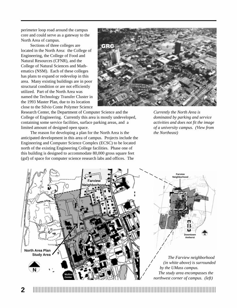
perimeter loop road around the campuscore and could serve as a gateway to theNorth Area of campus.
Sections of three colleges arelocated in the North Area: the College ofEngineering, the College of Food andNatural Resources (CFNR), and theCollege of Natural Sciences and Math-ematics (NSM). Each of these collegeshas plans to expand or redevelop in thisarea. Many existing buildings are in poorstructural condition or are not efficientlyutilized. Part of the North Area wasnamed the Technology Transfer Cluster inthe 1993 Master Plan, due to its locationclose to the Silvio Conte Polymer ScienceResearch Center, the Department of Computer Science and theCollege of Engineering. Currently this area is mostly undeveloped,containing some service facilities, surface parking areas, and alimited amount of designed open space.
The reason for developing a plan for the North Area is theanticipated development in this area of campus. Projects include theEngineering and Computer Science Complex (ECSC) to be locatednorth of the existing Engineering College facilities. Phase one ofthis building is designed to accommodate 80,000 gross square feet(gsf) of space for computer science research labs and offices. The
MullinsCenter
Governors Drive
GRC
Governors Drive
The Farview neighborhood(in white above) is surrounded
by the UMass campus. The study area encompasses the
northwest corner of campus. (left)
FarviewNeighborhood
Currently the North Area isdominated by parking and serviceactivities and does not fit the imageof a university campus. (View fromthe Northeast)
DowntownAmherst
FarviewNeighborhood
Conte
GRC
North Area PlanStudy Area
PVTA

312345678901234567890123456789012123456789012345678901234567890121234567890123456789012345678901212345678901234567890123456781234567890123456789012345678901212345678901234567890123456789012123456789012345678901234567890121234567890123456789012345678123456789012345678901234567890121234567890123456789012345678901212345678901234567890123456789012123456789012345678901234567812345678901234567890123456789012123456789012345678901234567890121234567890123456789012345678901212345678901234567890123456781234567890123456789012345678901212345678901234567890123456789012123456789012345678901234567890121234567890123456789012345678
first phase is planned to be completed by 1997. Phase two of theECSC is planned for engineering laboratory and office space, to becompleted around 1998-2000. The legislation which appropriatedfunding for both phases of this building requires that the two phasesbe physically connected at the first floor level. The location andimpact of this building were important driving forces for this study.
Planning ProcessThe North Area planning process began in October 1994 and
continued through April 1995. During this time many meetings wereheld with groups within the campus community and the public.Close coordination with the Campus Physical Planning Committeeand Facilities Planning was maintained throughout the entire plan-ning process. The Farview neighborhood residents were activelyinvolved in the process and were consulted regularly for input onplanning and development issues for the North Area. The planningteam attended most of the meetings of the Engineering and Com-puter Science Building Committee to insure that the building sitingand service coinsiderations were fully coordinated with the planningprocess.
College ofFood & NaturalResources
ParkingParking
Service
College ofFood & NaturalResources
The land uses in the North Area ofcampus consists of three colleges,service and parking.
EngineeringCollege ofNaturalSciences &Mathematics
Pond
PhysicalPlant
MullinsCenter

123456789012345678901234567890121234567890123456789012345678901212345678901234567890123456789012123456789012345678901234567812345678901234567890123456789012123456789012345678901234567890121234567890123456789012345678901212345678901234567890123456781234567890123456789012345678901212345678901234567890123456789012123456789012345678901234567890121234567890123456789012345678123456789012345678901234567890121234567890123456789012345678901212345678901234567890123456789012123456789012345678901234567812345678901234567890123456789012123456789012345678901234567890121234567890123456789012345678901212345678901234567890123456784
Discussions with the Deans of the three colleges located in theNorth Area (Engineering, NSM, CFNR) were held to talk about theirfuture expansion needs. Campus Services were consulted to deter-mine the parking needs in the North Area of campus and to discussvarious options for the Pioneer Valley Transit Authority (PVTA)facilities, such as the concept of developing a multi-modal transpor-tation facility. The service needs of the buildings on campus werealso discussed to determine methods of consolidating service accessinto nodes which could also support future construction.

512345678901234567890123456789012123456789012345678901234567890121234567890123456789012345678901212345678901234567890123456781234567890123456789012345678901212345678901234567890123456789012123456789012345678901234567890121234567890123456789012345678123456789012345678901234567890121234567890123456789012345678901212345678901234567890123456789012123456789012345678901234567812345678901234567890123456789012123456789012345678901234567890121234567890123456789012345678901212345678901234567890123456781234567890123456789012345678901212345678901234567890123456789012123456789012345678901234567890121234567890123456789012345678
Introduction
The 1993 Campus Physical Master Plan included a series ofinventory maps which described and documented existing conditionsfor the entire 1400 acre Amherst campus. This information plusadditional upgraded data to provide more detail for subarea planningbecame the basis for a summary assessment of influences andconstraints for North Area planning. The assessments include;environmental factors such as wetlands and slopes, pedestrian andvehicular circulation, land use and utilities. The limiting factors havebeen aggregated into a “Constraints Map”.
WetlandsThe wetland mapping included in the 1993 Master Plan was
based on information gathered by the U.S. National WetlandsInventory at a scale of 1:25,000. It was decided that a more accuratewetland delineation needed to be done for this study, and a consultantwas hired by the University’s Office of Facilities Planning to moreaccurately determine the extent of wetlands within and adjacent tothe North Area. The survey found several acres within the study areaand an extensive area of nearly 60 acres of wetlands just to the northand west of the study area. These wetlands include the Mill River
and its floodplain, a large redmaple swamp (Acer rubrum) andnumerous minor linear channelsand swales supporting wetlandshrub species (Alnus spp., Cornusspp.). While some of these wet-lands are natural, many resultedfrom the construction of Route 116and various campus developmentactivities. Regardless of theirorigins, all wetlands in the area aresubject to the MassachusettsWetlands Protection Act and localwetland bylaws (Hadley andAmherst, requiring a 50 and 100foot buffer, respectively, and amaximum of 5000 square feetdisturbance, with 1:1mitigationrequired.
The presence of this majorsystem of wetlands significantlylimits the potential of northcampus development. The exten-sive area of wetlands is a signifi-cant factor for the location of anyproposed roads or structures,
ExistingConditions
Wetlands define the western andnorthern edge of the campus.
FarviewNeighborhood
PVTA
Wetlands
GRC
E-LabGovernors Drive

123456789012345678901234567890121234567890123456789012345678901212345678901234567890123456789012123456789012345678901234567812345678901234567890123456789012123456789012345678901234567890121234567890123456789012345678901212345678901234567890123456781234567890123456789012345678901212345678901234567890123456789012123456789012345678901234567890121234567890123456789012345678123456789012345678901234567890121234567890123456789012345678901212345678901234567890123456789012123456789012345678901234567812345678901234567890123456789012123456789012345678901234567890121234567890123456789012345678901212345678901234567890123456786
especially for a connection to Route 116 or a northern connection toNorth Pleasant Street, both of which will most likely involve majorwetland crossings.
SlopesSlopes in the North Area are an important consideration for
locating future buildings, parking areas, roads and pedestrian walks.In general, the North Area land slopes consistently to the west at anaverage rate of 6.5 percent. This level of slope presents few signifi-cant constraints for development, and in fact provides opportunitiesfor “shelving” multiple story buildings into the slope, effectivelyreducing their height. The continuous slope also helps to minimizethe visual impact of new campus buildings on the views currentlyenjoyed from the Farview neighborhood. There are several localizedareas, however, where significant slopes over 20 percent occurwhich represent constraints for most future uses. These steep areasare located to the south of the Engineering Lab, to the east of theAstronomy lab and Gunness Lab, east of Holdsworth Hall, west ofBowditch Halls and west of Pioneer Valley Transit Authority (PVTA)facility.
VegetationThe vegetation in the existing academic portions of the North
Area consists primarily of turf with scattered tree and shrubplantings. The placement of most plants is not part of an overalllandscape design, and therefore does little to create quality in thedesign of outdoor spaces. One relatively successful area is theEngineering Quad, but even here the plantings do not contribute tosuccessful outdoor spaces, and they add little to the campus arbore-tum collection.
In contrast, the northern portion of the North Area outside ofthe academic core, has a large amount of natural vegetation. Most ofthis area has been recently disturbed and is now in early stages ofsuccession. The vegetation includes primarily wetland successionalplants and open meadows. The wetland vegetation is protected byMassachusetts, Hadley and Amherst Wetlands Protection Acts. Theremaining early successional vegetation in this area is not rare orsignificant and does not represent a constraint for potential futuredevelopment.
Visual AttributesA significant westward view of the Connecticut River Valley
including Mount Warner in Hadley and the Berkshire foothills existsfrom the North Area and is, in fact, the namesake for the Farviewneighborhood. The existing views have been somewhat compro-mised by an extensive area of parking and several storage buildingswhich are in disrepair. It is important to note, especially in terms ofthe view from the Farview neighborhood, that existing slopes

712345678901234567890123456789012123456789012345678901234567890121234567890123456789012345678901212345678901234567890123456781234567890123456789012345678901212345678901234567890123456789012123456789012345678901234567890121234567890123456789012345678123456789012345678901234567890121234567890123456789012345678901212345678901234567890123456789012123456789012345678901234567812345678901234567890123456789012123456789012345678901234567890121234567890123456789012345678901212345678901234567890123456781234567890123456789012345678901212345678901234567890123456789012123456789012345678901234567890121234567890123456789012345678
provide the opportunity to introduce new buildings in the North Areawithout completely blocking these significant views over the Con-necticut Valley. In this light the views are considered as an importantresource to be managed, rather than as a constraint for development.
Vehicular CirculationThe major vehicular circulation route through the North Area is
Governors Drive, an important link in the campus core’s perimetercirculation system. The present alignment of Governors Drive hasnumerous sharp turns and irregular curves, resulting from a litany ofincremental development decisions. In its present state GovernorsDrive is inefficient, unattractive and unsafe. The 1993 Master Planrecommended that realignment of Governors Drive be a priority toremedy the problems stated above and to complete the campusperimeter vehicular system. The eastern end of Governors Drivefrom North Pleasant Street to the first major curve near the newConte Polymer Research Building, abuts private property andtherefore has little or no space for widening or for the addition ofnew lanes. This easternmost section of the road will remain in itspresent form. The remainder of the existing road is consideredtemporary until a final realignment is designed and built.
The view to the West from the Farview Neighborhood looking over parking lot 31
123456789012345678901234567890121234567890123456789012345678901212345678901234567890123456789012123456789012345678901234567812345678901234567890123456789012123456789012345678901234567890121234567890123456789012345678901212345678901234567890123456781234567890123456789012345678901212345678901234567890123456789012123456789012345678901234567890121234567890123456789012345678123456789012345678901234567890121234567890123456789012345678901212345678901234567890123456789012123456789012345678901234567812345678901234567890123456789012123456789012345678901234567890121234567890123456789012345678901212345678901234567890123456788
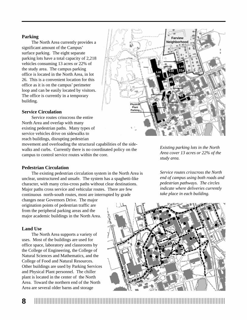
ParkingThe North Area currently provides a
significant amount of the Campus’surface parking. The eight separateparking lots have a total capacity of 2,218vehicles consuming 13 acres or 22% ofthe study area. The campus parkingoffice is located in the North Area, in lot26. This is a convenient location for thisoffice as it is on the campus’ perimeterloop and can be easily located by visitors.The office is currently in a temporarybuilding.
Service CirculationService routes crisscross the entire
North Area and overlap with manyexisting pedestrian paths. Many types ofservice vehicles drive on sidewalks toreach buildings, disrupting pedestrianmovement and overloading the structural capabilities of the side-walks and curbs. Currently there is no coordinated policy on thecampus to control service routes within the core.
Pedestrian CirculationThe existing pedestrian circulation system in the North Area is
unclear, unstructured and unsafe. The system has a spaghetti-likecharacter, with many criss-cross paths without clear destinations.Major paths cross service and vehicular routes. There are fewcontinuous north-south routes, most are interrupted by gradechanges near Governors Drive. The majororigination points of pedestrian traffic arefrom the peripheral parking areas and themajor academic buildings in the North Area.
Land UseThe North Area supports a variety of
uses. Most of the buildings are used foroffice space, laboratory and classrooms bythe College of Engineering, the College ofNatural Sciences and Mathematics, and theCollege of Food and Natural Resources.Other buildings are used by Parking Servicesand Physical Plant personnel. The chillerplant is located in the center of the NorthArea. Toward the northern end of the NorthArea are several older barns and storage
FarviewNeighborhood
Lot26
Lot31aLot
31b
45
45 65
Existing parking lots in the NorthArea cover 13 acres or 22% of thestudy area.
Service routes crisscross the Northend of campus using both roads andpedestrian pathways. The circlesindicate where deliveries currentlytake place in each building.
PhysicalPlant
Parking
41

912345678901234567890123456789012123456789012345678901234567890121234567890123456789012345678901212345678901234567890123456781234567890123456789012345678901212345678901234567890123456789012123456789012345678901234567890121234567890123456789012345678123456789012345678901234567890121234567890123456789012345678901212345678901234567890123456789012123456789012345678901234567812345678901234567890123456789012123456789012345678901234567890121234567890123456789012345678901212345678901234567890123456781234567890123456789012345678901212345678901234567890123456789012123456789012345678901234567890121234567890123456789012345678
buildings, including an old tobacco barn and other structures ownedby the University. One of these structures houses an academicprogram while the other, located at the end of Old Town Road, iscurrently being renovated by the Amherst chapter of Habitat forHumanity.
Parking lots account for 22% of the entire North Area, some ofwhich can be found within the academic core. Of the open areas thatare not paved, little is designed open space with a major exceptionbeing the Engineering Quad. The majority of open space in theNorth Area academic core is leftover space between pedestrianpathways and buildings. Outside the academic core, however, theland is almost entirely covered with natural vegetation with fewmanmade elements.
The study area is bordered by diverse uses. To the north is asubstantial area of University land consisting of forested wetland andsome scattered service activities. This largely vacant northern tractextends from Route 116 on the west to North Village on the North,and the Farview Residentail Neighborhood to the east. This northerntract includes an area between the wetlands and North Village thatmay be developed in the future, but is not specifically addressed inthis Plan. The Farview neighborhood, an established residential area,is a close neighbor abutting the eastern boundary of the study area.To the south of the study area is the campus core including majoracademic uses such as the Graduate Research Center, the Goessmancomplex and Draper Hall, as well as support services including theCampus Center, the Student Union and the parking garage. Parkinglots 25 and P are located to the west of the study area, just to thenorth of the William D. Mullins Center, the University’s showcaseathletic and performance facility. The site for the proposed co-generation power plant is located to the west of the study area.
UtilitiesUtilities in the North Area include water, sewer, storm drainage,
steam, chilled water, electrical and telecommunications. Severalimportant lines cross the North Area, and future development needsto carefully consider the position of these lines since relocation isexpensive and time consuming. A sewer line for the town ofAmherst also crosses the northwest corner of the North Area. Sincemost of the steam and chilled water lines are at or near capacity, theconnection points to the main University system will be an importantconsideration for any future construction. The proposed Co-genera-tion plant to be located on the northwestern side of the North Areawill require some modifications to current steam and electricaldistribution systems.

1234567890123456789012345678901212345678901234567890123456789012123456789012345678901234567890121234567890123456789012345678123456789012345678901234567890121234567890123456789012345678901212345678901234567890123456789012123456789012345678901234567812345678901234567890123456789012123456789012345678901234567890121234567890123456789012345678901212345678901234567890123456781234567890123456789012345678901212345678901234567890123456789012123456789012345678901234567890121234567890123456789012345678123456789012345678901234567890121234567890123456789012345678901212345678901234567890123456789012123456789012345678901234567810
Summary and AssessmentCurrently, the North Area of campus is a study in contrasts.
The academic portion of the Area has the appearance of a tiredindustrial area, with older buildings in need of extensive mainte-nance or demolition and most open space consisting of parking lots.The primary road, Governors Drive, is not up to standards and doesnot provide an attractive gateway to this part of campus. Circulation,both vehicular and pedestrian, is unclear, unsafe, and has no hierar-chy. The wetland adjacent to the North Area however, has greatnatural beauty and scenic views. It is protected under MassachusettsWetland Protection Act. The challenge for the University will be tobuild on the Area's assets and to bring the rest up to an appropriatelevel of excellence.
There are several factors emerging from this assessment ofexisting conditions that represent important constraints to planningand development in the North Area. These constraints, shown on theConstraints Map include:
• proposed Governors Drive right of way• reserving a buffer for the Farview Neighborhood• the wetland areas• localized areas of steep slope• utility corridors
The constraintsmap defines certainlimits to developmentthat are recognized andintegral to the develop-ment plan presented inthe following section.
Buffer ZoneUtility Corridor
Steep Slopes
Proposed Governor'sDrive Corridor
Wetlands

1112345678901234567890123456789012123456789012345678901234567890121234567890123456789012345678901212345678901234567890123456781234567890123456789012345678901212345678901234567890123456789012123456789012345678901234567890121234567890123456789012345678123456789012345678901234567890121234567890123456789012345678901212345678901234567890123456789012123456789012345678901234567812345678901234567890123456789012123456789012345678901234567890121234567890123456789012345678901212345678901234567890123456781234567890123456789012345678901212345678901234567890123456789012123456789012345678901234567890121234567890123456789012345678
Objectives
The goal for the North Area Plan is to establish a strongframework for future development in the north area of campusresponding to the present and future needs of the University and theadjacent neighborhood. In support of this goal four objectives havebeen defined for the North Area:
1. Realign Governors Drive to establish a symbolic and functionalnorthern boundary for the academic core and provide an appro-priate gateway to the North Area of the Campus.
Governors Drive will be designed as a secondary road in com-parison with North Pleasant Street and Commonwealth Avenue.
2. Implement an infill development policy for areas south ofrealigned Governors Drive, establishing an appropriate image forthe North Campus.
The realignment of Governors Drive will establish a northernlimit to the academic core. Within the North Area academic corean infill development policy will be implemented based on agross coverage ratio of 1:1 (four story buildings at 25% cover-age). Within this core area, service access will be planned tominimize conflicts with pedestrian paths.
3. Connect the north area of campus with the core campus throughstrong pedestrian corridors and open space.
As the North Area is redeveloped under this policy, a wellstructured, pedestrian oriented campus will be created, with clearlinks to the main campus core, as well as to perimeter parkinglots located to the north of Governors Drive. A clear heirarchyof pedestrian pathways must be layed out to link the north areawith the campus core. Guidelines set out in the Campus Land-scape Plan should be followed.
4. Coordinate future land uses to minimize conflicts between theUniversity and the Farview neighborhood.
A buffer area located between the Farview neighborhood andthe North Area will reduce noise and provide an attractive imagealong the northeast campus boundary. This buffer area willaccommodate attractive landscaping with pathways and openspace to be used by the residents and the campus community.
PlanComponents

1234567890123456789012345678901212345678901234567890123456789012123456789012345678901234567890121234567890123456789012345678123456789012345678901234567890121234567890123456789012345678901212345678901234567890123456789012123456789012345678901234567812345678901234567890123456789012123456789012345678901234567890121234567890123456789012345678901212345678901234567890123456781234567890123456789012345678901212345678901234567890123456789012123456789012345678901234567890121234567890123456789012345678123456789012345678901234567890121234567890123456789012345678901212345678901234567890123456789012123456789012345678901234567812
Vehicular Circulation
Governors Drive RealignmentA strategic recommendation in the Master Plan was the realign-
ment of Governors Drive to complete the loop road around thecampus core. The Master Plan states that the realignment “adds landto the campus core, provides safer and more efficient vehicularmovement and defines the northern campus edge.” (Campus PhysicalMaster Plan, university of Massachusetts Amherst, 19993. p. 35)
The realignment of Governors Drive directly impacts theplacement and scheduling of both phases of the proposed ECSC. Inaddition, the Farview Neighborhood is concerned about increasedroad noise and emissions from cars and trucks. In response to theseconcerns, three realignment options were explored, and the pros andcons of each were evaluated.
Option 1 - Minimal ChangeIn this proposal, Governors Drive would be moved only in the
area of the existing chiller plant. This solution results in an awk-wardly aligned road and does not address future building site propos-als.
Option 1 is a minimalist solution, not addressing the potentialfor inevitable future development. The concept of infill proposed inthe Master Plan is ignored in this option, as there would be noboundary set to curb future development. Pedestrian connectionsback into campus also would be difficult to establish and the bufferarea between the University and theneighborhood would be minimal.
Option 2 - Middle AlignmentIn Option 2, Governors Drive would
be realigned farther to the north than inOption 1, creating a defined boundary forfuture campus development. The roadwould be aligned to reduce traffic prob-lems and to create a more appropriatenorthern edge to the campus. This optionwould require that CommonwealthAvenue be extended northward to joinwith the realigned Governors Drive.
By moving Governors Drivenorthward, future development needscould be absorbed within its boundaryand a defined edge to the campus corewould be established. The land to thenorth could be preserved for open spaceand parking spaces north of the campuscore.
Wetlands
2
3
1
Three options for Governors Drivewere explored before deciding onOption 2. Also shown are theproposed connections to Route 116and land to the North.
Rt. 116Connection
NorthernConnector

1312345678901234567890123456789012123456789012345678901234567890121234567890123456789012345678901212345678901234567890123456781234567890123456789012345678901212345678901234567890123456789012123456789012345678901234567890121234567890123456789012345678123456789012345678901234567890121234567890123456789012345678901212345678901234567890123456789012123456789012345678901234567812345678901234567890123456789012123456789012345678901234567890121234567890123456789012345678901212345678901234567890123456781234567890123456789012345678901212345678901234567890123456789012123456789012345678901234567890121234567890123456789012345678
A buffer between the Farview neighborhood and the Universitycould also be established in this option. Governors Drive would beused as a boundary to future development eastward as well asnorthward, and the remaining land between the road and the neigh-borhood would remain as open space.
Option 3 - Upper AlignmentUnder this proposal, Governors Drive would be realigned to the
extreme north, just south of the wetlands. The road length and thecost of this proposal is higher compared to options 1 and 2. Parkingwould have to occur south of Governors Drive, within the campuscore, which goes against the 1993 Master Plan’s recommendationthat surface parking be kept outside the core.
The Farview neighborhood opposed this plan because noise andemissions would impact a greater proportion of the neighborhoodand development would likely move further to the north.
Realignment ConclusionThe preferred option for the realignment of Governors Drive is
Option 2 which creates a strong northern edge for the campus andprovides new sites within the core campus for future development. Italso creates a well-defined area for parking to the north whichfollows the Master Plan’s recommendation of keeping surfaceparking outside the campus core. Although Governors Drive movesto the north, a significant vegetated buffer zone will be createdbetween the road and the Farview neighborhood where a parking lotcurrently exists.
Because of siting issues for the Co-Generation Plant,Governor's Drive must connect to Commonwealth Avenue with acurve rather than in a "T" intersection. Special care will need to betaken to assure clear service connections off the road and safepedestrian crossings.
Connection to Route 116In order to address traffic concerns, especially those created by
the Mullins Center, possible direct connections to Route 116 wereexplored. Wetlands are the major constraint to the construction ofthis connection to Route 116.
A direct link to Route 116 would solve many of the existingcirculation problems that currently exist on campus. These includethe rush hour congestion at the intersection of Governors Drive andNorth Pleasant Street, service vehicle access and conflicts, andMullins Center event congestion to the East and South.
A Route 116 connection would run past the proposed Multi-modal Transportation Center, allowing students and visitors to utilizemass transit systems more efficiently. It would also be close to apotential new Service Distribution Center, allowing deliveries to bemade without entering or crossing the entire campus, presently amajor cause of service vehicle and pedestrian conflict.

1234567890123456789012345678901212345678901234567890123456789012123456789012345678901234567890121234567890123456789012345678123456789012345678901234567890121234567890123456789012345678901212345678901234567890123456789012123456789012345678901234567812345678901234567890123456789012123456789012345678901234567890121234567890123456789012345678901212345678901234567890123456781234567890123456789012345678901212345678901234567890123456789012123456789012345678901234567890121234567890123456789012345678123456789012345678901234567890121234567890123456789012345678901212345678901234567890123456789012123456789012345678901234567814
Future Northern ConnectorThe University owns the North Village residential area of
family housing units which constitutes the northern boundary of thecampus. Between North Village and the Wetlands is a tract ofapproximately 25 acres with some future development potential.This area is identified as "Reserve" on the Campus Physical MasterPlan. No development is anticipated within the planning horizon of1995-2015. However, access to this parcel from the campus coremust be planned now. A"T" intersection at Governor's Drive andCommonwealth Avenue will allow a clear connection to be made.
ParkingThe Master Plan recommended that most surface lots within the
campus core eventually be removed and replaced with new parkinglots outside the campus core and with parking structures within thecore. This North Area Plan proposes two new parking lots beconstructed to the north of the realigned Governors Drive outside ofthe campus core, to be built in two phases. The capacity of both lotswill be approximately 1200 vehicles. The remaining need forparking could be accommodated by a structure within the campus, tobe located either to the northwest of Holdsworth Hall or to the southof Paige Lab. A complete parking needs assessment and manage-ment plan needs to be done for the campus before a final proposalcan be made.
Service ExpansionThe potential exists in the North
Area to consolidate and expand some ofthe service facilities for the Universityand to move them out of the core campus.Three new uses are proposed:
1. A Co-generation Plant2. A service center and central
receiving/distribution building3. A multi-modal transportation
facilityA co-generation plant is proposed
north of the realigned Governors Driveand to the west of the CommonwealthAvenue extension. Siting criteria for thisfacility included; proximity to the exist-ing main steam distribution connection,outside of the campus core, and as faraway from the Farview neighborhood aspossible. This new plant will most likelyuse either natural gas or oil to generatesteam for the University along withelectricity for the plant . The design and
Service Center
Multi-ModalTransportationFacility
Proposed locations of majorservice expansions located justwest of the North Area.
Co-Gen Plant
FutureDevelopmnentArea
North VillageN
orth Pleasant S
t.
A potential development area existswith potential access to campus,North Pleasant Street and NorthVillage.

1512345678901234567890123456789012123456789012345678901234567890121234567890123456789012345678901212345678901234567890123456781234567890123456789012345678901212345678901234567890123456789012123456789012345678901234567890121234567890123456789012345678123456789012345678901234567890121234567890123456789012345678901212345678901234567890123456789012123456789012345678901234567812345678901234567890123456789012123456789012345678901234567890121234567890123456789012345678901212345678901234567890123456781234567890123456789012345678901212345678901234567890123456789012123456789012345678901234567890121234567890123456789012345678
construction has been sent out to bid, with construction expected tobegin in 1996 and the plant brought on-line in 1998.
A Service Distribution Center has been proposed to the south ofthe Co-Generation Plant near the existing cold storage building. Thisstructure would consolidate campus services which are presentlyscattered about the campus including; the central mailroom, dupli-cating services, and central receiving. The key to this location isdirect access to Route 116, via the potential new connection. Thiswould allow large delivery trucks to deliver bulk goods withouthaving to enter the campus core. Items such as paper could then bedivided and transferred into smaller vehicles for delivery on campus.
The Multi-modal transportation facility located just to the northof Mullins Center would serve as the center for transportation aroundthe entire campus. It would be a place for students, faculty and staff,and visitors to park their vehicles and catch a shuttle bus to variouscampus destinations. A bicycle connection to the Norwattuck RailTrail (aka Five College Bikeway )could terminate here, with bikeracks and lockers. This facility would also provide a convenient andefficient location for a University motor pool. The location of thefacility adjacent to the future Route 116 connector would allow foruse of the facility for Mullins Center traffic as well.
In addition, the plan accounts for the expansion of the ChillPlant to twice its current footprint size as indicated on the North AreaPlan. The entire Chill Plant site will be screened with plantings onall four sides to minimize the visual impact of the facility.
Bus StopsWith the realignment of Governors Drive and
the other future developments in the North Area, itwill be necessary to plan for new bus stops alongthe road. These bus stops will include pull-outzones of 120 feet in length for the buses. A busstop could be located directly across from the newECSC building for easy pedestrian access to thisbuilding. This pull1-out lane could then serve as adrop-off lane for employees and students going tothe building.
Service AccessService access to any new development in the
North Area needs to be planned from the beginningof the process. Service access will be located innodes which access several buildings at one time,minimizing the access roads and potential conflictswith pedestrian circulation.
Service to the ECSC building is planned forthe west side of the building. Future buildingsconstructed to the west of ECSC will also be
Service routes (gray dashed lines)need to be consolidated to minimizeconflicts between service vehiclesand pedestrians.

1234567890123456789012345678901212345678901234567890123456789012123456789012345678901234567890121234567890123456789012345678123456789012345678901234567890121234567890123456789012345678901212345678901234567890123456789012123456789012345678901234567812345678901234567890123456789012123456789012345678901234567890121234567890123456789012345678901212345678901234567890123456781234567890123456789012345678901212345678901234567890123456789012123456789012345678901234567890121234567890123456789012345678123456789012345678901234567890121234567890123456789012345678901212345678901234567890123456789012123456789012345678901234567816
Proposed Pedestrian Circulation
The pedestrian cirulation system must clearly link the NorthArea with the center of campus and be consistent with campus-wideplanning. The proposed pedestrian system has been conceived as astrong framework, within which future development parcels arelocated. When implemented, this pedestrian framework will provideclear functional and visual structure. Pedestrian corridors will beappropriately furnished with plantings, lighting, furniture, edgingand signage to provide safety, legibility and enjoyment.
Specifics include:1. A tree-lined sidewalk
along realigned Gover-nors Drive and Com-monwealth Ave.
2. A primary North-southroute from the CampusPond, along StudentUnion and contuinuingtoward the EngineeringLabs.
3. East-west routesstrengthened to the northof Marcus and Marston.
serviced by this node. Another node needs to remain at the north endof Marcus Hall, to service the existing buildings in the area and anynew construction near that location. Another service node wouldfollow the western section of the existing Governor's Drive to servicethe buildings around Holdsworth to Knowles Building.
4. Extension of pathwayto new Multi-modalfacility.
5. East-west route southof GRC.
- Removal of negativevisual elements alongthese routes
- Incorporate landscap-ing elements alongpaths
- Remove unnecessarypaths and consolidatethe spaces intolandscaping areas foradjacent buildings orseating areas.
The proposed pedestrian circulationframework (light grey) providesclear connections between majordestinantions.

1712345678901234567890123456789012123456789012345678901234567890121234567890123456789012345678901212345678901234567890123456781234567890123456789012345678901212345678901234567890123456789012123456789012345678901234567890121234567890123456789012345678123456789012345678901234567890121234567890123456789012345678901212345678901234567890123456789012123456789012345678901234567812345678901234567890123456789012123456789012345678901234567890121234567890123456789012345678901212345678901234567890123456781234567890123456789012345678901212345678901234567890123456789012123456789012345678901234567890121234567890123456789012345678
Landscape Issues
The ArboretumThe 1993 Campus Physical Master Plan called for the Waugh
Arboretum to become the theme for the campus landscape. Thedevelopment of the North Area will support the Arboretum as anintegral part of any design and planning. This area of campus willbenefit from close attention to new plantings in order to createdefined open spaces and corridors. The proposed ECSC buildingand the proposed realignment of Governors Drive represent impor-tant short term opportunities to make significant contributions to theWaugh Arboretum.
The wetland areas north of the study area should remain in anatural state. This section of campus holds potential for research andstudy into wetland plants and succession, and should therefore be anintegral part of the Arboretum and landscape for learning.
The Neighborhood BufferWith the realignment of Governors Drive, several parcels of
land to the east of the new road will be put aside as a permanentbuffer for the neighborhood. This buffer will serve as a visual andacoustic barrier between the neighborhood and the campus to theextent possible. It will include a strip of trees and shrubs near theneighborhood, and a fence on which vines could be grown. If theroad is dug into the existing contours even just a few feet, the impacton the neighborhood would be greatly reduced. Open space will beintegrated within the buffer space for both the University and theNeighborhood. A jogging trail may also be integrated within thisbuffer space.
Buffer Service ExpansionThe proposed service expansion areas, including the Co-
Generation Plant, the Service Distribution center, and the Multi-modal Center, will be visually screened from pedestrian and vehicu-lar circulation paths. These buffers will be an integral part of thedesign with the purpose of maintaining the maximum visual quality.This will maintain the gateway concept on the north border of the
campus.

1234567890123456789012345678901212345678901234567890123456789012123456789012345678901234567890121234567890123456789012345678123456789012345678901234567890121234567890123456789012345678901212345678901234567890123456789012123456789012345678901234567812345678901234567890123456789012123456789012345678901234567890121234567890123456789012345678901212345678901234567890123456781234567890123456789012345678901212345678901234567890123456789012123456789012345678901234567890121234567890123456789012345678123456789012345678901234567890121234567890123456789012345678901212345678901234567890123456789012123456789012345678901234567818
Future Campus Development
The North Area of the campus, as defined by the study areaboundaries for the North Area Plan, has potential for development inthree general land use categories: (1) academic facilities, (2) private/partnership developments and (3) utilities and support services.
Academic FacilitiesFuture academic facilities will be located south of the re-
aligned Governors Drive, and east of the extension of Common-wealth Avenue. The plan indicates twelve (12) sites for the construc-tion of new academic facilities. An additional three (3) sites mightbe available in the future if redevelopment efforts included thereplacement of current facilities on these sites.
The first two development sites are actively being plannedand designed to accommodate the Engineering/Computer ScienceResearch Center. The Computer Science Department will occupy a3-story, 80,000 gross square foot building constructed on Site #1 onthe North Area Plan. The College of Engineering is planning for abuilding to be constructed on Site #2 which will be approximately60,000 gross square feet. The two projects will be connected by aclassroom facility which will physically join the two projects atground level.
Site #3 will be reserved for the future expansion of theEngineering Building, and Site #4 will be reserved for the futureexpansion of the Computer Science Department and its researchaffiliates. Sites #5-10 have not been designated for specific pur-poses, but will be reserved for potential future academic develop-ment. Site #11 is a potential site for a parking garage to service theNorth Area.
The three redevelopment (R) sites for academic development asshown on the North Area plan are dependent on the planning andreplacement of the current facilites at these locations.
To fit the character of the campus, some development guide-lines must be followed with regard to height, floor area and setback.The purpose is to define the edges of the campus and create strongpedestrian corridors. The following guidelines will help to achievethese results. The gross site area for each infill site has been calcu-lated to provide an estimate of thr potential gross square feet ofbuilding at one times coverage.
Site Development Guidelines Development Yield1 Current proposal for Phase 1 80,000 gsf
of the Engineering and ComputerScience Complex (ECSC).
Height limited to 3 stories to maintain views fromthe Farview neighborhood.Setbacks to accommodate pedestrian circulationcorridors, as well as design guidelines for circulationand landscape enhancements.

1912345678901234567890123456789012123456789012345678901234567890121234567890123456789012345678901212345678901234567890123456781234567890123456789012345678901212345678901234567890123456789012123456789012345678901234567890121234567890123456789012345678123456789012345678901234567890121234567890123456789012345678901212345678901234567890123456789012123456789012345678901234567812345678901234567890123456789012123456789012345678901234567890121234567890123456789012345678901212345678901234567890123456781234567890123456789012345678901212345678901234567890123456789012123456789012345678901234567890121234567890123456789012345678
Willam D.
Mullins Center
Buffer
4Governors Drive
R
Rt 116Connection
Knowles
GRC
Marcus
2
3
1
7
8
9
R
R
11
10
6
Parking
Garage
The NorthArea Plan
5
12
Polymer
Science
PossibleMulti-ModalTransportationCenter
PossibleServiceCenter
Wetlands
New Roads
Designed Open Space
Infill Building Sites
Major Pedestrian CorridorService Routes

1234567890123456789012345678901212345678901234567890123456789012123456789012345678901234567890121234567890123456789012345678123456789012345678901234567890121234567890123456789012345678901212345678901234567890123456789012123456789012345678901234567812345678901234567890123456789012123456789012345678901234567890121234567890123456789012345678901212345678901234567890123456781234567890123456789012345678901212345678901234567890123456789012123456789012345678901234567890121234567890123456789012345678123456789012345678901234567890121234567890123456789012345678901212345678901234567890123456789012123456789012345678901234567820
2 Current proposal for Phase 2 60,000 gsfof the ECSC building.
Must be connected to Phase 1 of ECSC at grade.Height limited to 3 stories to maintain views fromthe Farview neighborhood. Setbacks toaccommodate proposed pedestrian corridor.
3 Reserved for future expansion of 70,000 gsfEngineering Bldg.
Connected with Phase 2 of ECSC. Provide anat grade north/south pedestrian passage throughthe building to link with the ECSC courtyard.Height limited to 4 stories to maintain consistentheight with surrounding buildings.
4 Reserved for future academic use. 95,000 gsf
Maintain Governors Drive setback established forECSC Phase 1building. Height limited to 4 stories,to maintain views from the Farview neighborhood.Provide setbacks for service access and majorpedestrian corridors to the core.
5 Reserved for future academic use. 50,000 gsf
Height of building limited to 4 stories, to maintainviews from Farview neighborhood. Maintainsetbacks to accommodate major pedestrian corridorand proposed service access
6 Reserved for future academic use. 30,000 gsf
Maintain Governors Drive setback established forECSC Phase 1building. Provide setback toaccommodate major pedestrian corridor to thecampus core. Height of building limited to 4 stories,to maintain views from Farview neighborhood.Reserved for future academic use.
7 Reserved for future academic use. 40,000 gsf
Building height limited to 4 stories. Maintain setbacks for pedestrian corridor and serviceaccess.
8 Reserved for future academic use. 100,000 gsf
Limit building height to 4 floors. Maintain thesame setback along Commonwealth Ave as theMullins Center to establish a clear westerncampus edge.

2112345678901234567890123456789012123456789012345678901234567890121234567890123456789012345678901212345678901234567890123456781234567890123456789012345678901212345678901234567890123456789012123456789012345678901234567890121234567890123456789012345678123456789012345678901234567890121234567890123456789012345678901212345678901234567890123456789012123456789012345678901234567812345678901234567890123456789012123456789012345678901234567890121234567890123456789012345678901212345678901234567890123456781234567890123456789012345678901212345678901234567890123456789012123456789012345678901234567890121234567890123456789012345678
9 Reserved for future academic use. 120,000 gsf
Limit building height to 4 floors. Maintainsetback for major pedestrian corridor to the core.Maintain setback for buildings alongCommonwealth Ave. (same as Site 8).
10 Reserved for future academic use. 95,000 gsf
Limit building height to 3 floors to maintain viewsfrom Holdsworth Hall. Maintain setback fora major pedestrian corridor to the campus core.Maintain setbacks for service access.
11 Parking garage. 144,000 gsf 400 parking spaces (100 spaces/level)
Maximum 3 floors above grade, to maintaincomparable height with surrounding buildings.Potential for a fourth level below grade. Providesetbacks which accommodate both vehicular andpedestrian access.

1234567890123456789012345678901212345678901234567890123456789012123456789012345678901234567890121234567890123456789012345678123456789012345678901234567890121234567890123456789012345678901212345678901234567890123456789012123456789012345678901234567812345678901234567890123456789012123456789012345678901234567890121234567890123456789012345678901212345678901234567890123456781234567890123456789012345678901212345678901234567890123456789012123456789012345678901234567890121234567890123456789012345678123456789012345678901234567890121234567890123456789012345678901212345678901234567890123456789012123456789012345678901234567822
12 Computer Science - Public/Private 10,000 gsfPartnership
Should be connected to Phase I of ECSC at grade.Height limited to 2 stories to maintain views fromthe Farview neighborhood.
Private/Partnership DevelopmentThe plan proposes two opportunities for the development of
private/partnership research facilities. There is a small site directlyeast of the ECSC (Site #8) which is envisioned to be a small additionto the ECSC building to house private research partners of theComputer Science Department.
A second opportunity may be possible through the redevel-opment of the facility which currently houses the Pioneer ValleyTransit Authority (PVTA) services. With frontage on both a re-aligned Governors Drive and an extended Commonwealth Avenue,this site may be an attractive, visible location for a technologytransfer facility which might attract and encourage heightenedinteraction between University researchers and private industry. Thisconcept is also consistent with the 1993 Master Plan strategicrecommendations.
Special legislation to allow the development of privately-ownedfacilities, or the redevelopment of properties with private participa-tion, on state property will be needed if either of these opportunitiesare to be pursued.
Service ExpansionThe North Area Plan proposes three major service expansion
areas:1. A Power Plant for steam generation.2. A service center and central receiving / distribution building.3. A multi-modal transportation facility.
Each of these proposals are described on pages 14-15.

2312345678901234567890123456789012123456789012345678901234567890121234567890123456789012345678901212345678901234567890123456781234567890123456789012345678901212345678901234567890123456789012123456789012345678901234567890121234567890123456789012345678123456789012345678901234567890121234567890123456789012345678901212345678901234567890123456789012123456789012345678901234567812345678901234567890123456789012123456789012345678901234567890121234567890123456789012345678901212345678901234567890123456781234567890123456789012345678901212345678901234567890123456789012123456789012345678901234567890121234567890123456789012345678
Recommendations
The first phases of development of the North Area are scheduledto begin in the Spring of 1996. The realignment of Governors Driveand the construction of the first set of perimeter parking lots north ofthe realigned road will begin by this date. The next major projectwill be the construction of the Computer Science building; slated forFall 1996, and occupancy in late 1997 or ealy 1998. Immediatelyfollowing the completion of the Computer Science building will bethe construction of the Engineering Building and the instructionalfacilities which join the two projects.
There is considerable development opportunity illustrated in theNorth Area Plan for future projects. In order to assure the orderlydevelopment, and the maximum capitalization on the opportunities,the following recommendations are offered for further planning andstrategic decisionmaking:
1. There should be continued coordination between the relocationof surface parking spaces to perimeter lots, the transition ofinterior parking spaces to structures, and the development offuture projects in the study area. A timeline for such a transitionshould be coordinated with an overall parking management planfor the campus.
2. Efforts should be made to close Old Governors Drive, or at leastseverely restrict access, once the new alignment is in place.
3. The feasibility study for the Multi-Modal Transportation Centershould proceed as soon as possible in conjunction with theparking management plan and bicycle route planning for thecampus.
4. Planning for on-road and off-road bicycle paths/lanes shouldproceed to clearly articulate the connections to the North Area, tothe multi-modal transportation center, to the regional bike pathsystem and to the University property to the north of the studyarea.
5. Traffic and circulation studies should proceed to determine thefeasibility of extensions of Commonwealth Avenue to the northand to the west (to Rte. 116).
6. The site for the proposed co-generation power plant should becontained to the west of a potential northerly extension ofCommonwealth Avenue. The smallest possible site should bereserved for this use to minimize the impact on the North Areadevelopment and the neighborhood.
Conclusion
1234567890123456789012345678901212345678901234567890123456789012123456789012345678901234567890121234567890123456789012345678123456789012345678901234567890121234567890123456789012345678901212345678901234567890123456789012123456789012345678901234567812345678901234567890123456789012123456789012345678901234567890121234567890123456789012345678901212345678901234567890123456781234567890123456789012345678901212345678901234567890123456789012123456789012345678901234567890121234567890123456789012345678123456789012345678901234567890121234567890123456789012345678901212345678901234567890123456789012123456789012345678901234567824
7. The campus must find ways to introduce private investment andjoint venture partnership projects into the North area. Opportu-nities have been identified within the plan for this type ofdevelopment, but special legislation and cooperative agreementsneed to be in place for this development to occur.
8. The campus must begin to plan for the rehabilitation, or demoli-tion with replacement, of some of the oldest structures in oradjacent to the study area. It may be time to consider redevelop-ment plans for these strategic development sites within the coreof the campus; taking a long range view of improvements asillustrated in the North Area Plan.
9. The sooner action is taken on the proposed Arboretum Plan, thebetter the chance that it will have a strong influence on the NorthArea development. Certainly opportunities for developingsubstantial pieces of an arboretum collection are contained in theNorth Area Plan proposals; including buffer zone landscapeprojects, tree-lined streets and pathways, connections to thewetland areas for instruction and conservation purposes, andparking lot landscaping.