Embed Size (px)
Citation preview

COASTAL
A Report of theNational CoastalAssessment Group
For theU.S. Global ChangeResearch Program
October 2000
The Potential Consequencesof Climate Variability and Change
NOAA Coastal Ocean ProgramDecision Analysis Series No.21
DECISION ANALYSIS SERIES
The Decision Analysis Series has been established byNOAA’s Coastal Ocean Program (COP) to presentdocuments for coastal resource decision-makers whichcontain analytical treatments of major issues or topics.The issues, topics, and principal investigators have beenselected through an extensive peer review process. Tolearn more about the COP or the Decision AnalysisSeries, please write:
NOAA Coastal Ocean Program1315 East-West Highway
Silver Spring, Maryland 20910
phone: 301-713-3338fax: 301-713-4044
web: www.cop.noaa.gov

THE POTENTIAL CONSEQUENCESOF CLIMATE VARIABILITY AND CHANGE
ON COASTAL AREASAND MARINE RESOURCES
Report of theCoastal Areas and Marine Resources Sector Team
U.S. National Assessment of the Potential Consequencesof Climate Variability and Change
U.S. Global Change Research Program
Edited byDonald F. Boesch
John C. FieldDonald Scavia
Assessment TeamDonald F. Boesch, Donald Scavia, Robert W. Buddemeier, Virginia Burkett,
Daniel R. Cayan, John C. Field, Michael Fogarty, Mark A. Harwell, Robert W. Howarth,Curt Mason, Richard Park, Leonard Pietrafesa, Denise J. Reed, C. Thomas Royer,
Ashbury H. Sallenger, Michael Spranger, and James G. Titus
Science for Solutions
NOAA’s COASTAL OCEAN PROGRAMDecision Analysis Series Number # 21
U.S. DEPARTMENT OF COMMERCENorman Y. Mineta, Secretary
National Oceanic and Atmospheric AdministrationD. James Baker, Undersecretary for Ocean and Atmosphere
National Ocean Service Margaret A. Davidson, Acting Assistant AdministratorNational Centers for Coastal Ocean Science
Donald Scavia, Chief ScientistCoastal Ocean Program
David Johnson, Director
October 2000

EditorsDonald F. Boesch, University of Maryland Center for Environmental Science
John C. Field, University of WashingtonDonald Scavia, National Ocean Service, NOAA
Assessment TeamDonald F. Boesch, University of Maryland Center for Environmental Science
Donald Scavia, National Ocean Service, NOAARobert W. Buddemeier, Kansas Geological Survey, University of Kansas
Virginia Burkett, National Wetlands Research Center, USGSDaniel R. Cayan, University of California, San Diego
John C. Field, University of WashingtonMichael Fogarty, National Marine Fisheries Service, NOAA
Mark A. Harwell, University of MiamiRobert W. Howarth, Cornell University
Curt Mason, National Ocean Service, NOAARichard Park, Eco-Modeling
Leonard Pietrafesa, North Carolina State UniversityDenise J. Reed, University of New OrleansC. Thomas Royer, Old Dominion University
Ashbury H. Sallenger, Center for Coastal Geology, USGSMichael Spranger, University of Washington
James G. Titus, Office of Economy and Environment, USEPA
This publication should be cited as:Boesch, D.F., J.C. Field, and D. Scavia, (Eds.) 2000. The Potential Consequences of Climate Variability andChange on Coastal Areas and Marine Resources: Report of the Coastal Areas and Marine ResourcesSector Team, U.S. National Assessment of the Potential Consequences of Climate Variability and Change,U.S. Global Change Research Program. NOAA Coastal Ocean Program Decision Analysis Series No. #21. NOAA Coastal Ocean Program, Silver Spring, MD. 163 pp.
This publication does not constitute an endorsement of any commercial product or intend to bean opinion beyond scientific or other results obtained by the National Oceanic and AtmosphericAdministration (NOAA). No reference shall be made to NOAA, or this publication furnishedby NOAA, in any advertising or sales promotion which would indicate or imply that NOAArecommends or endorses any proprietary product mentioned herein, or which has as its purposean interest to cause directly or indirectly the advertised product to be used or purchased becauseof this publication.

The Potential Consequences of Climate Variability and Change on Coastal Areas and MarineResources was prepared by a team of scientists, co-chaired by Drs. Donald F. Boesch and DonaldScavia. The National Oceanic and Atmospheric Administration served as the lead agency for thissectoral team of the U.S. National Assessment of the Potential Consequences of Climate Variabilityand Change. This report is being used as a key resource the National Assessment’s overviewreport.
The Coastal Ocean Program (COP) provides a focal point through which NOAA, together withother organizations with responsibilities for the coastal environment and its resources, can makesignificant strides toward finding solutions to critical problems. By working together toward thesesolutions, we can ensure the sustainability of these coastal resources and allow for compatibleeconomic development that will enhance the well-being of the Nation now and in future generations.The goals of the program parallel those of the NOAA Strategic Plan.
A specific objective of the COP is to provide the highest quality scientific information to coastalmanagers in time for critical decision-making and in formats useful for these decisions. To helpachieve this the COP inaugurated a program of developing documents that would synthesizeinformation on issues that were of high priority to coastal managers. As a contribution to theDecision Analysis Series, this report provides a critical synthesis of the potential consequences ofa changing climate during the 21st century on the coastal ocean and its living resources. A list ofavailable documents in the Decision Analysis Series can be found on the inside back cover.
As with all of its products, the COP is very interested in ascertaining the utility of the DecisionAnalysis Series, particularly in regard to its application to the management decision process.Therefore, we encourage you to write, fax, call or e-mail us with your comments. Please be assuredthat we will appreciate these comments, either positive or negative, and that they will help usdirect our future efforts. Our address and telephone and fax numbers are on the inside front cover.My Internet address is [email protected].
David Johnson, Ph.D.DirectorNOAA Coastal Ocean Program
Note to Readers
Many institutional colleagues contributed greatly to the development of this report in terms ofideas, examples and helpful criticism. The Coastal Areas and Marine Resources Assessment Teamparticularly thanks: Hector Galbraith, who contributed to the shorebirds case study; Jim Allen andDon Cahoon, who assisted in the assessment of coastal wetland impacts; Elizabeth Turner, whoprovided background information on GLOBEC; and Rob Thieler, who contributed to the sectionon predicting coastal evolution.
The authors also thank the National Assessment Synthesis Team for its stimulating leadership andits staff, which helped in so many ways. Particularly notable was the patient and dedicated assistanceprovided by Ben Felzer, Mike MacCracken, LaShaunda Malone, Melissa Taylor, and JustinWettstein.
Peer reviewers of the report helped greatly in pointing out areas of over or under interpretation,inconsistencies, and important references. These reviewers included: Peter Becker, Suzanne Bricker,Ann Carlson, Mark Davis, Ben Felzer, William Fox, Vivian Gornitz, John Marra, Robert Morton,Susan Moser, Al Strong, Todd Tisdale, Elizabeth Turner, and Warren Wooster. All interpretationsand conclusions in the report are those of the Assessment Team; it not should be inferred that theyreflect the views of the reviewers.
Finally, we extend our gratitude to Jane Hawkey and Marc Suddleson for the copyediting andfinal production of the report and to Paul Grabhorn for the cover design.
Acknowledgements
Table of Contents
LIST OF FIGURES AND TABLES ix
EXECUTIVE SUMMARY xiii
CHAPTER 1: INTRODUCTION 11.1 The U.S. National Assessment 11.2 Methodology 2
CHAPTER 2: COASTAL AREAS AND MARINE RESOURCES IN CONTEXT 52.1 Coastal Areas and Human Populations 62.2 The Importance of Coastal Resources to Society 8
CHAPTER 3: CLIMATE FORCES 113.1 Ocean Temperatures 123.2 Ocean Currents 18
Case Study: Scenarios for the Coastal Northeast Pacific Ocean 243.3 Hurricanes and Extratropical Storms 263.4 Precipitation and Freshwater Runoff 30
Case Study: Freshwater Flows to the San Francisco Bay/Delta Estuary 323.5 Sea-Level Change 35
Case Study: Sea-Level Rise and Migratory Shorebirds 41
CHAPTER 4: IMPACTS TO COASTAL AND MARINE ENVIRONMENTS 454.1 Shorelines and Coastal Developed Areas 46
Case Study: Economic Impacts of Sea-Level Rise 51Case Study: Adaptation to Sea-Level Rise on Long Beach Island, New Jersey 53
4.2 Wetlands 56Case Study: Wetland Loss in Coastal Louisiana 65Case Study: South Florida Regional Ecosystems 70
4.3 Estuaries 76Case Study: Mid-Atlantic Estuaries 78Case Study: Hypoxia and Climate in the Gulf of Mexico 85
4.4 Coral Reefs 89Case Study: Kaneohe Bay, Oahu, Hawaii 102
4.5 Ocean Margins and Fishery Resources 103Case Study: Pacific Salmon and Climate 112

viii Table of Contents
CHAPTER 5: ADAPTATION AND FUTURE RESEARCH 1175.1 Adaptation and Coping Strategies 117
Case Study: Implications of Sea-Level Rise for Specific Federal Programs 1245.2 Research Needs and Ongoing Research Efforts 1285.3 Recommendations 133
REFERENCES 135

List of Figures and Tables
FIGURES
Figure 2.1 Projected percentage increase in population for coastal counties 6of the United States between 2000 and 2025 (NPA 1999).
Figure 2.2 Projected economic growth for coastal counties of the United 7States between 2000 and 2025, as a percentage of currenteconomic output (NPA 1999).
Figure 3.1 Changes in the heat content of the upper 3000 m of the Atlantic 13Ocean between 1948 and 1998 (Levitus et al. 2000). Vertical linesrepresent ± 1 SE.
Figure 3.2 Change in the extent of summer sea ice in the Arctic projected by 18the Canadian Climate Center model.
Figure 3.3 Climatic forces have many direct and indirect effects on important 19biological processes in the ocean.
Figure 3.4 Major Pacific and Atlantic Ocean current systems of importance 19to North America.
Figure 3.5 The ocean plays a major role in the distribution of the planet’s heat 23through deep sea thermohaline circulation connecting the world’soceans (modified from Broecker 1991). Often referred to as the ocean“conveyor belt”, this climate regulating system brings temperateweather to northwestern Europe and could dramatically slow as aresult of global warming as it has in the geological past.
Figure 3.6 Losses of life and property by decade resulting from hurricanes making 27landfall in the continental U.S. (Source: National Hurricane Center,NOAA).
Figure 3.7 The number of hurricanes making landfall on the U.S. coast of the Gulf 27of Mexico by decade over the past 100 years, showing peaks of activityduring the early 20th century as well as in the 1960’s. (Source: FloridaState University, Center for Ocean-Atmosphere Prediction.)

Figure 3.8 Projected changes in average annual runoff for basins draining 31to coastal regions of the conterminous U.S. estimated fromprecipitation and temperature projections of the Canadian andHadley Center GCMs (from Wolock and McCabe, 1999).
Figure 3.9 Recent average relative sea-level change rates in inches per 38decade (Titus 1998). These are general trends. Sea-level changerates often vary greatly within states, for example relative sealevel rose 1.5 to 2 inches/decade in southern Puget Sound as aresult of subsidence and fell at the same rate on the northwestcoast of Washington as a result of uplift of the land mass.
Figure 3.10 Reconstructions (over the past 100 years) and projections 39(over the next 100 years) of global sea level from the HadleyClimate Centre and Canadian Climate Center General CirculationModels. Hadley model simulations include the effects of glacialmelting as well as thermal expansion of the ocean, while theCanadian model considers only thermal expansion.
Figure 3.11 Projections of sea-level change (in meters) around North America 40near the end of the 21st century by the Canadian Climate Center(left) and Hadley Climate Centre (right) models. These do notinclude the effects of subsidence or uplift on relative sea level,but do indicate that the rise in the level of the ocean will not beuniform because of the effects of currents and winds around thecontinental margins.
Figure 3.12 Scenarios for the rates and extent of sea-level change for Willapa 42Bay (A) and South San Francisco Bay (B) based on the SeaLevel Affecting Marshes Model (SLAMM4).
Figure 4.1 Classification of the rate of shoreline erosion throughout the 46United States (after Dolan et al. 1985).
Figure 4.2 Estimated land loss for seven regions of the U.S. without 49shoreline protection based on projections of current rates (baseline)and sea-level rise of 50 cm and 100 cm over this century (afterTitus et al. 1991).
Figure 4.3 Estimated incremental costs of four alternative responses to sea-level 55rise on Long Beach Island, NJ (Titus 1990).
x The Potential Consequences of Climate Variability and Change

Figure 4.4 How coastal wetlands respond to sea-level rise depends greatly on 60the supply of sediments with which soils can be accretedsufficiently to allow the surface of the wetland to gain elevation.With high sediment supplies coastal marshes and mangroves canpersist even under high rates of relative sea-level rise. (Reed 1999).
Figure 4.5 Areal extent of mid-summer hypoxia of bottom waters of the 84Northern Gulf of Mexico continental shelf between 1985 and 1999(no data collected in 1989). The extent of hypoxia in a given yearis greatly influenced by the volume of freshwater discharge andassociated nutrient loadings from the Mississippi River Basin(CENR, 2000).
Figure 4.6 Annual flux of nitrate from the Mississippi River Basin to the 86Gulf of Mexico, 1955-1999, and mean annual streamflow, 1950-1999 (Goolsby 2000).
Figure 4.7 Organism responses to changing conditions or resources, plotted 91on arbitrarily normalized axes. Note that the upper and lower lethallimits and the maximum response in the “saturation” range are allcontrolled by different variables. (Buddemeier and Smith 1999).
Figure 4.8 Figure 4.8 Effects of increasing CO2 on coral calcification rates. 93Increasing levels of atmospheric CO2 (Houghton et al. (1996) areprojected to decrease carbonate ion concentrations in seawater,likely resulting the calcification rates of many reef-buildingspecies (Gattuso et al. 1999).
Figure 4.9 Maps of aragonite saturation state distribution based on the model 94results of Kleypas et al. (1999a). Locations of present reefs and reefcommunities are shown (www.cgiar.org/iclarm/resprg/reefbase/frameg/).Classification intervals for saturation effects on reef systems arederived from Kleypas et al. (1999b).
Figure 4.10 Annual areal extent of unusually warm (>2°C over usual high 95temperatures) sea surface temperatures in tropical seas. Widespreadand severe coral bleaching has been associated with periods ofunusually warm temperatures, often associated with El Niñoconditions (Strong et al. 2000).
Figure 4.11 The Pacific Decadal Oscillation (PDO) index (five-year moving 104average) and landings of California sardine in British Columbia,Oregon and Washington (PNW) between 1900 and 1960 andCalifornia from 1977.
List of Figures and Tables xi

Figure 4.12 Equilibrium yield as a function of fishing pressure under two 110sets of environmental conditions. The upper (solid) curve representsthe production function under favorable environmental conditions,while the lower (dashed) curve represents less favorableenvironmental conditions.
Figure 4.13 Variability in Alaskan and Pacific coast salmon landings related to 112positive and negative phases of the Pacific Decadal Oscillation(PDO) index. (Mantua et al. 1997).
Figure 5.1 Strategies for coping with sea-level rise on barrier islands. A 120retreat strategy would involve no protection and no rebuilding as sealevel rose, while adaptation strategies could include an engineeredretreat, island raising or protection by levees, dikes and otherstructures. (Source: J. Titus, U.S. Environmental Protection Agency.)
Figure 5.2 A prototype policy for a rolling easement in which bulkheads and 122filling of private land are prohibited where they interfere with wetlandtransgression, except to the extent necessary to maintain use of theproperty. (Source: J. Titus, U.S. Environmental Protection Agency.)
Figure 5.3 Vulnerability of coastlines to sea-level rise in the New York-New 132Jersey region is closely related to coastal landform type and trends invertical land movement. (Source: USGS.)
TABLES
Table 2.1 Population Projections for Coastal Counties (in 1000’s of persons) 7iand Percent Change from 1999 Baseline (NPA 1999).
Table 3.1 Key issues involving coastal areas and marine resources identified 12in the National Assessment Overview (NAST 2000) for major U.S.regions. Wholly inland regions, including the Great Lakes, are notincluded.
Table 4.1 Classification matrix for stress-inducing variables 91
Table 4.2 Anthropogenic stresses on coral reef systems and scale of their 97effects (R, regional; L, local)
Table 4.3 Classes of U.S. coral reefs by region (Veron, 1995) 99
xii The Potential Consequences of Climate Variability and Change

Executive Summary
Coastal and marine ecosystems support diverse and important fisheries throughout the nation’swaters, hold vast storehouses of biological diversity, and provide unparalleled recreationalopportunities. Some 53% of the total U.S. population live on the 17% of land in the coastal zone,and these areas become more crowded every year. Demands on coastal and marine resources arerapidly increasing, and as coastal areas become more developed, the vulnerability of humansettlements to hurricanes, storm surges, and flooding events also increases.
Coastal and marine environments are intrinsically linked to climate in many ways. The ocean is animportant distributor of the planet’s heat, and this distribution could be strongly influenced bychanges in global climate over the 21st century. Sea-level rise is projected to accelerate during the21st century, with dramatic impacts in low-lying regions where subsidence and erosion problemsalready exist. Many other impacts of climate change on the oceans are difficult to project, such asthe effects on ocean temperatures and precipitation patterns, although the potential consequencesof various changes can be assessed to a degree. In other instances, research is demonstrating thatglobal changes may already be significantly impacting marine ecosystems, such as the impact ofincreasing nitrogen on coastal waters and the direct effect of increasing carbon dioxide on coralreefs.
Coastal erosion is already a widespread problem in much of the country and has significant impactson undeveloped shorelines as well as on coastal development and infrastructure. Along the PacificCoast, cycles of beach and cliff erosion have been linked to El Niño events that elevate averagesea levels over the short term and alter storm tracks that affect erosion and wave damage along thecoastline. These impacts will be exacerbated by long-term sea-level rise. Atlantic and Gulf coastlinesare especially vulnerable to long-term sea-level rise as well as any increase in the frequency ofstorm surges or hurricanes. Most erosion events here are the result of storms and extreme events,and the slope of these areas is so gentle that a small rise in sea level produces a large inland shiftof the shoreline. When buildings, roads and seawalls block this natural migration, the beaches andshorelines erode, threatening property and infrastructure as well as coastal ecosystems.
Estuaries are extremely productive ecosystems that are affected in numerous ways by climate.Climate change may result in a narrowing of the annual water temperature range of temperatezone estuaries, as winter temperatures increase while summer temperatures increase less becausethey are moderated by evaporative cooling. This could allow for species range shifts and increasethe vulnerability of some estuaries to invasive species. Climate models forecast significant increasesor decreases in precipitation and river runoff in various parts of the country and such changes willaffect salinity and water circulation. Increased runoff would likely deliver increased amounts ofnutrients such as nitrogen and phosphorous to estuaries while simultaneously increasing the

xiv The Potential Consequences of Climate Variability and Change
stratification between warmer fresher and colder saltier water. This would increase the potentialfor algal blooms that deplete the water of oxygen and increase stresses on sea grasses, fish, shellfish,and benthic communities. Decreased runoff could diminish flushing, decrease the size of estuarinenursery zones, and allow predators and pathogens of shellfish to penetrate the estuary more deeply.However, changes in water delivery may have beneficial impacts to some systems as well.
Wetlands and mangroves are highly productive systems that are strongly linked to fisheriesproductivity; particularly in the Southeast, these habitats provide important nursery and habitatfunctions to many commercially important fish and shellfish populations. Infilling, subsidence,altered hydrology and curtailed supply of sediments have driven dramatic losses of wetlands inthis region. In general, coastal wetlands are capable of surviving if they remain at the same elevationrelative to the tidal range, which occurs if their soil accretion equals the rate of relative sea-levelrise, or if the wetland is able to migrate inland. If this migration is blocked by bluffs, coastaldevelopment, or shoreline protective structures, then the wetland will be inundated and eventuallylost as rising seas submerge the remaining habitat.
Coral reefs are also extremely valuable resources, providing numerous fisheries opportunities,recreation, tourism, and coastal protection wherever they exist. In addition, reefs are one of thelargest global storehouses of marine biodiversity, with vast untapped resources of genetic andbiochemical materials and scientific discoveries regarding the evolution of life. The last few yearshave seen unprecedented declines in the condition of coral reefs. The 1998 El Niño in particularwas associated with record sea-surface temperatures and associated coral bleaching. There hasalso been an upsurge in the variety, incidence and virulence of coral diseases in recent years, withmajor die-offs reported in Florida and much of the Caribbean region. In addition, increasingatmospheric CO2 concentrations reduce the alkalinity of surface waters, which in turn decreasesthe calcification rates of the reef-building corals. The result to coral reefs will very probably beweaker skeletons, reduced growth rates and increased vulnerability to erosion.
Climate change will have important implications for marine ecosystems that support ecologicallyand economically important fish populations. As a result of changes in ocean conditions, thedistribution and abundance of major fish stocks will probably change substantially. Along thePacific Coast, impacts to fisheries related to the El Niño/Southern Oscillation illustrate how climatedirectly impacts marine fisheries on short time scales. Elevated sea surface temperatures associatedwith the 1997-98 El Niño had a great impact on the distribution and abundance of market squid,California’s largest fishery by volume. Landings fell to less than 1,000 metric tons in the 1997-98season, down from a record-breaking 110,000 tons in the 1996-97 season. Many other unusualevents occurred during this same El Niño as a result of elevated sea-surface temperatures. Examplesinclude widespread sea lion pup deaths in California, catches of warm-water marlin in the usuallyfrigid waters off Washington State, a series of anomalous plankton blooms, seabird die-offs alongthe Aleutian Islands, and poor salmon returns in Bristol Bay, Alaska.
Differentiating the effects of climate from human activities in all of these systems is extremelydifficult. In general, anthropogenic disturbances often reduce the ability of systems to adapt, sothat systems that might ordinarily be capable of responding to the stresses of climate variability

Executive Summary xv
and change are less able to do so. It is in this context that climate change will act as major force forcoastal and marine environments, interacting with the cumulative impact of both natural and human-caused stresses on ecological systems and resources.
With few exceptions, the potential consequences of climate change are not yet being considered ina management context, despite the fact that it has been shown that planning protection or retreatstrategies for coastal developments can substantially reduce the economic impacts of inundationand shoreline migration. Some of these exceptions are the coastal management programs in Maine,Rhode Island, South Carolina, and Massachusetts, which have implemented various forms ofeasement policies to ensure that wetlands and beaches can migrate inland as sea-level rises.However, scientific uncertainties and the long time scales relative to more immediate problemscontinue to act as barriers to the development and adoption of management responses. Thus,coping strategies should fully consider and integrate climate variability and change into coastalplanning, and implement mitigation and adaptation mechanisms that offer the best chance for thelong-term sustainability of coastal resources.


Chapter 1
Introduction
The issues and problems associated with coastal and marine resources, and their current or potentialrelationship to climate, have continued to receive a high level of national and international attention.Headlines draw attention to subjects ranging from disastrous hurricanes and one of the strongestEl Niño events in recent history, to the latest collapse of marine fish stocks and massive coral reefdie-offs associated with elevated sea surface temperatures. Thus it should come as no surprise thatclimate variability, and the potential consequences of future climate change, are of considerableinterests to stakeholders, policymakers and the general public, especially as they may act as anadditional stressor to coastal and marine resources.
The primary objective of this assessment is to detail the potential impacts to coastal and marineresources associated with climate variability and potential climate change. This is done within theguidelines generated by the National Assessment Synthesis Team, as described below. While thefocus will be on the impacts of climate to coastal and marine resources, it has also proven necessaryto focus on climate forcing mechanisms to set the stage for those impacts. In addition, individualcase studies, which focus on specific ecosystems or issues, have been included to generate anunderstanding of specific examples of climate impacts.
1.1 THE U.S. NATIONAL ASSESSMENT
Congress mandated that the U.S. Global Change Research Program (USGCRP) to undertake aNational Assessment of the Potential Consequences of Climate Variability and Change (P.L. 101-606). To meet this mandate, a process has been developed and applied by the National AssessmentSynthesis Team (1998) to analyze and evaluate what is known about the potential consequencesof climate variability and change in the context of other pressures on the public, the environment,and the nation’s resources. The National Assessment Synthesis Team is a federal advisorycommittee, drawn from experts from academia, Federal and State agencies, non-governmentalorganizations, and the private sector.
The National Assessment has three primary components: (1) an analysis which considers the impactson major economic sectors (water resources, agriculture, forests, coastal areas and marine resources,and human health); (2) regional analyses which identify and characterize potential impacts onsome twenty selected geographical regions and are performed by teams of local experts from bothpublic and private sectors; (3) reports that summarize climate model projections and the regionaland sector assessments, drawing together these results in a comprehensive National Assessment.All of the regional, sector and synthesis analyses, to the degree possible, have used a common setof scenarios for climate change and socio-economic forecasts. These assessments examine potential
2 The Potential Consequences of Climate Variability and Change
consequences over the next 30 years as well as the next 100 years of significant secular changes inclimate resulting from projected increases in atmospheric carbon dioxide concentrations. Potentialconsequences over all time frames consider the possibility of non-linear and threshold responses,especially as might be accompanied by changes in current modes of climate variability or theintensity and frequency of extreme events.
The sectoral and regional assessments have generated, through workshops and quantitative analysis,substantive reports which assess the implications of the National Assessment scenarios. The CoastalAreas and Marine Resources Sector held three workshops and engaged in substantive discussionand thorough review in its attempt to generate the content envisioned by the National AssessmentSynthesis Team. This report is the product of this work. Readers interested in the science behindclimate change, climate change assessments, general circulation models and other impacts aredirected towards the National Assessment Synthesis Team Overview (NAST 2000) and theIntergovernmental Panel on Climate Change (Houghton 1996) reports. Additionally, the productsgenerated by the many regional assessments are invaluable with regard to more detailed region-specific analysis of potential impacts and consequences to localized communities, and interestedparties are strongly encouraged to refer to these sources for additionally information.
1.2 METHODOLOGY
Most of the attention devoted to coastal areas and marine resources in past climate changeassessments has focused on the potential impacts of accelerated sea-level rise for islands, shorelines,wetlands and coastal communities. While accelerated sea-level rise is indeed a significantconsequence of climate change on marine systems, there are many other potential impacts associatedwith climate that affect a wide range of coastal and marine ecosystems and services. Indeed, thereare other significant consequences of changes in biogeochemical cycles on a global scale notnecessarily directly related to climate. For example, there are direct consequences to coral reefsand possibly submerged aquatic vegetation (SAV) of increasing atmospheric carbon dioxide levels,independent of the effect CO2 has on climate. There are also consequences resulting from dramaticchanges in the availability of nitrogen and other nutrients in coastal and marine systems resultingfrom anthropogenic activities.
Assessing the effects of climate variability and change on coastal areas and marine resources ismade more difficult by the confounding effects of other human activities. Anthropogenic disturbanceoften results in the reduction in the adaptive capacity of systems to change and stress, and maymask the physical and biological responses of many systems to climate forces. For example,naturally functioning estuarine and coastal wetland environments would typically be expected tomigrate inland in response to relative sea-level rise, as they have done throughout time. However,when such migration is blocked by coastal development, diking, filling, or hardening of uplandareas, such habitat is gradually lost by “coastal squeeze” as rising sea-levels push the remaininghabitat against developed or otherwise altered landscape. In a similar fashion, biologicalcommunities which might be able to tolerate and adapt to changes in temperature, salinity or

Chapter 1: Introduction 3
productivity associated with variable climate regimes might be less able to do so under thecumulative effects of intensive harvest pressure, eutrophication, habitat loss, competition by non-native species and exposure to pollutants or toxins.
Thus, the second section of this assessment focuses on the general status and trends in coastal andmarine resources, and in particular on evaluating current and future impacts associated withpopulation concentration and growth in the coastal zone. This section also describes recent trendsin the use and management of coastal and marine resources in fisheries, recreation, tourism,development and other societal sectors. From there it moves to a discussion of socio-economicscenarios and forecasts which were used in assessing how changes in demographics, land use, andeconomics may interact with future climate variability and change to affect coastal and marineresources.
A comprehensive review on climate forcing makes up the third section of this assessment. Thishas proven to be challenging, due in no small part to the difficulties in ascribing historical variabilityand model projections to specific effects in coastal systems. This assessment has focused on plausibleprojections of forcing mechanisms, including sea-level rise rates, changes in storm tracks andfrequencies, alteration of freshwater flow regimes, shifts in coastal ocean temperatures ranges andextremes, changes in ocean current patterns and changes associated with large scale atmosphericprocesses. However, this assessment was not written to provide a review of all of the relationshipsbetween oceans, coastlines and climate; such an undertaking would necessarily fill volumes. Thereader interested in further resources which address such topics in detail is referred to the IPCCreports (Houghton et al. 1996), as well as NRC (1998), Biggs (1996), Mann and Lazier (1996),and other references cited in this report.
The section on climate forcing is intended to provide a brief foundation for assessing the real andpotential impacts of climate to various types of coastal and marine ecosystems. These section areintended to be the primary product of this assessment. Specifically, the five principal ecosystemtypes examined for the purposes of this assessment were coastal wetlands, estuaries, shorelines,coral reefs and ocean margins. While there is significant overlap in many of these ecosystemtypes, and there are of course further divisions within these ecosystems as well, this breakdownprovides a framework for understanding what may be the most significant anticipated impacts onecological systems. The human component of these systems in critical; indeed, for the section onshorelines the resources of principal focus are those developed coastal areas and human settlementswhich are vulnerable to climate impacts. These sections focus primarily upon impacts which areeither already occurring or are likely based on past modes of climate variability, forcing scenariosand change thresholds.
To complement the sections on potential impacts, case studies have been inserted throughout thetext of this assessment in order to provide specific examples of the complex set of interactionsbetween the effects of climate and human activities. This will allow readers to understand bettermany of the general issues associated with climate and various coastal and marine ecosystemtypes, as well as to consider the interaction of multiple climate-related forces within specific regions.

Case studies have also, to the extent practicable, included discussion of potential response strategieswhich could be appropriate in coping with current and future modes of change. This assessmentdoes not cover potential consequences to the shorelines and lacustrine resources of the GreatLakes region. These were considered by a separate regional assessment under the NationalAssessment.
Finally, the sections on ecological impacts and the case studies set the stage for drawing conclusionsregarding the greatest vulnerabilities and opportunities for coastal areas and marine resourcesrelated to current climate variability and future climate change. In this section, the assessmentteam has attempted to highlight adaptation and coping strategies which could help society toprepare for future consequences. Quite understandably, much remains to be learned with regard tocoping with future changes and their associated uncertainties. Thus the assessment concludes bydetailing critical information and data gaps, providing direction for future research and assessments,and suggesting some basic principles which might be considered in the context of coastal resourcemanagement challenges already being faced.
4 The Potential Consequences of Climate Variability and Change
Chapter 2
Coastal Areas and Marine Resources inContext
The United States has one of the longest and most diverse coastlines in the world, extending over158,000 kilometers (over 95,000 miles), ranging in habitat type from the tropical Pacific in AmericanSamoa to the permafrost and usually ice covered Arctic Sea in northern Alaska. Over half of thisshoreline is found in Alaska. Within these coastal areas lie nearly 39,000 square kilometers (15,000square miles) of coastal wetlands (high and low salinity marshes, mangroves, and forested wetlandssuch as baldcypress swamps) and 6500 square kilometers (2,500 square miles) of barrier islands.The United States also has management authority over living marine resources within some 8.8million square kilometers (3.4 million square miles) of ocean within its territorial sea, includingsome 16,800 square kilometers (6,500 square miles) of coral reefs. All of these ecosystems supporta wide array of habitats and an enormously diverse array of species and communities, and are offundamental importance to human and societal well being.
Just a few of the ecological services provided by coastal habitats include flood control and waterquality improvement by coastal wetlands; the tremendous productivity for fisheries and wildlifeof wetlands, estuaries, and the coastal ocean; the buffering effects of storms by barrier islands;and the vast biodiversity in coral reef ecosystems. Coastal areas are used for a wide range ofoverlapping and often competing uses such as tourism, coastal development and residential living,commercial and recreational fisheries, aquaculture, navigation, trade, national defense, and mineralresource extraction. No less importantly, coastal and marine ecosystems are intrinsically linked toplanetary biological and geochemical cycles. Subsequently the health and functioning of theseecosystems is critically important to the health of the planet as a whole.
Although a growing national and international awareness of the importance of the coasts andoceans has increased concern for the integrity of these resources, demands on coastal and marineenvironments are growing as population and affluence increase both within the United States andglobally. In many instances this awareness has generated laws, agencies or programs to mitigateand reverse environmental decline and resolve conflicts. However, there is growing consensusthat management on all levels (international, federal, state and local), has not been able to keeppace with the overall increase in pressure on coasts and marine areas (NRC 1997a). The trend ofincreasing population and pressure on the nation’s coastline is certain to continue, intensifyingpressure and stress on coastal and marine resources. Thus, the effects of climate change will beexperienced concurrently with ongoing and growing pressures due to increasing population anddevelopment in most coastal areas.

2.1 COASTAL AREAS AND HUMAN POPULATIONS
Already, the majority of the population of the United States lives within 130 kilometers (80 miles)of the coast, and population growth in coastal areas is more rapid than in the country as a whole.Currently it is estimated that 53% of the total population of the United States lives in approximately17% of the U.S. land area that is considered coastal (Culliton 1998). These coastal areas arebecoming more crowded every year, by far surpassing the national population increase over thelast 40 years. In 1960 there was an average of 72 people per square kilometer of coastal land (187per square mile, excluding Alaska). By 1994 this had increased to some 105 people per squarekilometer (273 per square mile) and by 2015 this figure is expected to rise to 126 people persquare kilometer (327 per square mile; Culliton 1998). Coastal areas also include 19 of the 20most densely populated counties in the country, 17 of the 20 fastest growing counties in the country,16 of the 20 counties with the largest number of new housing units under construction and 18 ofthe 20 leading counties in per capita income.
To put real numbers on these projections, based on the mid-range population projections used inthe National Assessment (NAST 2000), over the next 25 years population gains of some 18 millionpeople are projected to occur in the coastal states of Florida, California, Texas, and Washington(NPA 1999). Note that we have considered “coastal” counties to be those included in state coastalzone management plans; whereas Culliton classified as coastal all counties located either entirelyor partially within coastal watersheds. Thus, the absolute numbers may vary slightly betweenthese two estimates, although the trends and implications are certainly consistent. Table 2.1 showsprojected growth in coastal counties on a state-by-state basis between 2000 and 2025. Similarly,Figure 2.1 shows these same changes graphically for all coastal counties in the U.S., and Figure2.2 shows projected economic growth for the same counties. With this ongoing population growth,as well as increased wealth and affluence, rapidly increasing demands on coastal areas and marineresources for both aesthetic enjoyment and economic benefits will continue.
6 The Potential Consequences of Climate Variability and Change
Figure 2.1. Projected percentage increase in population for coastal counties of the United States between2000 and 2025 (NPA 1999).

Chapter 2: Coastal Areas and Marine Resources in Context 7
Figure 2.2. Projected economic growth for coastal counties of the United States between 2000 and 2025,as a percentage of current economic output (NPA 1999).
Table 2.1. Population Projections for Coastal Counties (in 1000’s of persons)and Percent Change from 1999 Baseline (NPA 1999).
State Current 2005 2010 2015 2020 2025 Total % Change
Alabama 549 569 594 619 645 672 22.4Alaska 555 602 666 732 800 870 56.9California 25208 26175 27475 28892 30419 32032 27.1Connecticut 2043 2032 2027 2033 2047 2070 1.3Delaware 749 762 778 797 819 842 12.4Florida 14663 15800 17248 18751 20297 21889 49.3Georgia 546 572 607 644 682 721 32.2Hawaii 1212 1261 1327 1398 1473 1550 27.9Louisiana 2738 2801 2887 2981 3082 3190 16.5Maine 761 785 817 850 886 923 21.3Maryland 3419 3467 3553 3663 3795 3944 15.4Massachusetts 4659 4696 4765 4860 4979 5116 9.8Mississippi 353 366 385 406 428 451 27.6New Hampshire 407 433 462 489 514 539 32.5New Jersey 7303 7291 7305 7357 7437 7545 3.3New York 13623 13477 13376 13373 13443 13577 -0.3North Carolina 823 864 917 973 1031 1091 32.4Oregon 1331 1412 1512 1614 1719 1826 37.2Pennsylvania 2827 2794 2777 2785 2811 2853 0.9Rhode Island 997 1001 1012 1029 1052 1079 8.3South Carolina 955 1024 1112 1202 1295 1389 45.4Texas 5365 5659 6034 6426 6833 7255 35.2Virginia 3308 3430 3595 3771 3955 4145 25.3Washington 4137 4432 4810 5203 5610 6029 45.7
Total 98529 101706 106040 110851 116054 121597 24.4

This large and growing population pressure in coastal areas is responsible for many of the currentpressures on coastal resources. For example, the Environmental Protection Agency (1996) estimatedthat nearly 40% of the nation’s surveyed estuaries are impaired by some form of pollution orhabitat degradation. Some 30 to 40% of shellfish growing waters in the nation’s estuaries haveharvest prohibited or restricted each year, primarily due to bacterial contamination from urbanand agricultural runoff and septic systems (Alexander 1998). Additionally, over 3,500 beachadvisories and beach closings occurred in the United States in 1996, primarily due to storm-waterrunoff and sewage overflows (NRDC 1997). Population pressures and land and resource usesfarther inland also have detrimental impacts on coastal resources. Effluent discharges as well asagricultural runoff have caused significant nutrient over-enrichment in many coastal areas. Sewageand siltation can be significant drivers of coral reef degradation in Hawaii, Florida and U.S. affiliatedislands of the Pacific and Caribbean. Dams, irrigation projects and other water control effortshave further impacted coastal ecosystems and shorelines by diverting or otherwise altering theflow of water, sediments and nutrients.
Thus, the list of ongoing stresses to coastal environments is very long and growing. A committeeestablished by the National Research Council to identify priorities for coastal ecosystem science,generated one short list of key threats to the integrity of coastal ecosystems. These includeeutrophication, habitat modification, hydrologic and hydrodynamic disruption, exploitation ofresources, toxic effects, introduction of non-indigenous species, global climate change andvariability, shoreline erosion and hazardous storms, and pathogens and toxins affecting humanhealth (NRC 1994). While this list is not entirely inclusive, the synergies of these ongoing andincreasing stresses with climate are key themes and will be exemplified in the sections on impactsand in the case studies below.
2.2 THE IMPORTANCE OF COASTAL RESOURCES TO SOCIETY
Despite these ongoing stresses to coastal environments, the oceans and coastal margins provideunparalleled economic opportunities and revenues. One estimate suggests that as many as one outof every six jobs in the U.S. is marine related, and nearly one-third of the gross domestic product(GDP) is produced in coastal areas (NOAA 1998; NRC 1997a). In 1996, approximately $590billion worth of goods passed through U.S. ports; over 40% of the total value of U.S. trade and amuch larger percentage by volume. New technology has also spurred vast new industries dependenton coastal and marine resources. In the growing field of marine biotechnology, recent researchhas yielded five drugs originating from marine organisms with a cumulative total potential marketvalue of over $2 billion annually (NOAA 1998).
Fisheries, both commercial and recreational, are a tremendously important economic activity incoastal areas. The U.S. is the world’s fifth largest fishing nation and the third largest seafoodexporter. Total landings of marine stocks have averaged about 4.5 million metric tons per yearover the last decade. Estimates are that the total long-term potential yield – the maximum averagecatch that could be achieved from all of the nation’s fisheries – is over 8 million metric tons per
8 The Potential Consequences of Climate Variability and Change
year for U.S. stocks (NMFS 1999). Ex-vessel value, the amount that commercial fishers are actuallypaid for their catch, was estimated at approximately $3.5 billion for 1997. The total cumulative(direct and indirect) economic contribution of recreational and commercial fishing has beenestimated at over $40 billion per year (NRC 1999). However, nearly 30% of the commerciallyfished species for which trends are known were considered overfished in 1998, while the status ofthe vast majority of stocks remains unknown (NMFS 1998). Catastrophic fish population collapsesand economic disasters have struck most regions of the country. For example in January 2000, theWest Coast groundfish fishery joined the New England groundfish fishery in being declared inserious trouble by the Secretary of Commerce. Such fishery collapses have dramatic impacts toboth marine ecosystems and the coastal communities which have long been dependent upon thesemarine resources.
Coastal tourism also generates enormous revenues to coastal communities. Travel and tourism aremulti-billion dollar industries in the U.S., representing the second largest employer in the nation(after health care), employing as many as 6 million people (NOAA 1998). It has been estimatedthat the U.S. receives over 45% of the developed world’s travel and tourism revenues, whichgenerate as much as $58 billion per year in tax revenues for all levels of government (Houston1996). Oceans, bays and beaches are among the most popular tourist destinations in the nation,surpassing even national parks and historic sites in terms of their visitation. As many as 180million people visit the coast each year for recreational purposes in all regions of the country, andmany regions depend upon tourism as a key economic activity. For example one study estimatedthat in the San Francisco Bay area alone tourism has been estimated to generate over $4 billion ayear (USEPA 1997). Clean water, healthy ecosystems and access to coastal areas are critical tomaintaining tourism industries, ironically, however, these industries themselves often poseadditional impacts to coastal environments and local communities (Miller and Auyong 1991).
As coastal populations increase, the vulnerability of developed coastal areas to natural hazards isalso expanding. The most recent numbers indicate that there are an estimated 276,000 householdslocated in areas considered high hazard due to storm surge, and an additional 2.4 million householdslocated in flood plains adjacent to high risk zones (FEMA 1991). Disaster losses are currentlyestimated at about $50 billion annually in the U.S., compared to just under $4.5 billion in 1970. Asmuch as 80% of these disasters were storms, hurricanes and tornadoes (as opposed to geologicallyrelated disasters such as earthquakes and volcanoes) and most of these had their greatest impactson coastal communities. For example, in the last decade alone Hurricanes Hugo, Andrew andGeorges caused, respectively, an estimated $9 billion, $27 billion and $5.9 billion, in damages tocoastal communities. Meteorologists and climatologists are constantly improving predictivecapability, reducing the risks of death and injury to coastal populations through improved forecastsand preparedness by coastal communities. However, the growing concentration of population anddevelopment in coastal areas will ensure that future damages from hazards will continue to riseindependent of ongoing and future climatic influences.
In addition to direct economic benefits, coastal and marine ecosystems, like all ecosystems, havecharacteristic properties or processes which directly or indirectly benefit human populations.
Chapter 2: Coastal Areas and Marine Resources in Context 9
Costanza et al. (1997) have attempted to estimate the economic value of seventeen ecosystemgoods and services in sixteen biomes, or ecosystem types, including nutrient cycling, disturbanceregulation, waste treatment, food production, raw materials, refugia for commercially andrecreationally important species, genetic resources, and opportunities for recreational and culturalactivities. For example, the societal values of estuaries, tidal marshes, coral reefs and coastaloceans were estimated at $22,832, $9,990, $6,075 and $4,052 per hectare respectively. On a globalbasis, the authors suggested that these environments were of a disproportionately high value;covering only some 6.3% of the world’s surface area but responsible for some 43% of the estimatedvalue of the world’s ecosystem services. These results suggest that the oceans and coastal areascontribute the equivalent of some $21 trillion per year to human activities globally (Costanza1999).
The approach of Costanza et al. (1997) to valuation is not universally accepted, and the authorsthemselves agree that ecosystem valuation is difficult and fraught with uncertainties. However,the magnitude of their estimates, and the degree to which coastal and marine ecosystems rank asamongst the most valuable to society, serve to place the importance of the services and functionsof these ecosystems in an economic context. As fisheries declines, ongoing problems with coastaleutrophication and increasing storm damages indicate, the capacity of coastal systems to providethese essential services and buffer against the continuing pressures from human development andactivities is decreasing. Continuing population growth and development are likely to decrease theresilience of these systems further. It is in this context that climate change will act as an additionalstress on these environments, further increasing the vulnerability of both these ecosystems and thecoastal communities that depend upon them.
10 The Potential Consequences of Climate Variability and Change

Chapter 3
Climate Forces
Coastal and marine environments are intrinsically linked to, and affected by, climate on all timescales. Precipitation patterns and freshwater runoff, sea surface temperatures and ocean currents,wind, solar radiance, tides, long-term sea-level changes, and numerous additional forcing factorsall influence and shape the geophysical and biological nature of coastal landforms, habitats, andecosystems. Covering some 71% of the earth’s surface, the oceans play a critical role in the climatesystem. They are the major receiver and distributor of incoming solar radiation, with major oceancurrents moving heat energy polewards from the equator. Evaporation of water vapor from thesurface of the oceans provides latent heat energy to the atmosphere and fuels the hydrologicalcycle as well as the generation of storms, hurricanes and cyclones. The oceans modulate seasonaland longer variations in climate, and act as a feedback mechanism for weather and climate acrossall temporal and spatial scales.
Mean temperatures in the ocean directly affect sea-level through thermal controls, and indirectlythrough feedbacks which partially control the amount of the earth’s water tied up in glaciers, icesheets and the hydrological cycle. The oceans also store heat through thermohaline circulation, inwhich heat energy in surface waters is transported and distributed into the deep ocean for thousandsof years. The oceans are also one of the largest reservoirs of carbon in the biogeochemical system,and moderate the extent of change by acting as a sink for increasing atmospheric carbon dioxide.The oceans are thought to be taking up about one third of the carbon dioxide released byanthropogenic emissions (Siegenthaler and Sarmiento 1993). While speculation as to how the roleof the coasts and oceans might change relative to future global change remains difficult, the potentialfor significant and extreme change should not be discounted.
The climate forces that have consequences for coastal areas and marine resources can be groupedinto the following five categories: temperature, ocean currents and dynamics, atmospheric storms,freshwater inputs from land, and sea level variations. These forces interact, however, and a givenregion will experience the consequences of multiple climate forces. Separate assessment teamswithin the National Assessment considered the consequences of climate variability and changefrom a regional perspective. These regional assessments were aggregated for even larger super-regions of the nation for which key issues were identified in the National Assessment Overview(NAST 2000). Table 3.1 provides a thumbnail summary of the key issues identified for thesesuper-regions that involve coastal areas and marine resources, listed under the five primary climateforces. The lack of mention of a climate force issue for a region does not necessarily mean that itis not an issue for the region, merely that it did not rise to the high level of concern meritingattention in the National Assessment Overview. Nonetheless, this summary indicates that for allregions of the nation bordering on the ocean there are multiple concerns and that some concernsare in common among the regions while others are different.

Table 3.1. Key issues involving coastal areas and marine resources identified in the National AssessmentOverview for major U.S. regions. Wholly inland regions, including the Great Lakes, are not included.
Region Temperature Ocean Currents Coastal Storms Freshwater Inputs Sea-level Rise
Northeast Stresses on Threats of storm Changes in amount Coastal wetlandestuaries and surge on urban and timing of loss and limitsbays resulting transportation runoff to estuaries to migrationfrom sea-level rise
Southeast Hurricane risks Water quantity Coastal wetlandto coastal and quality and barrier loss;development and saline intrusionstorm surge in swamp forestsflooding
West Changes in and Loss of coastalcompeting uses for wetlands inwater resources San Francisco Bay
Pacific Effects of climate Changing in Impacts onNorthwest variability on timing of flows coastal erosion
salmon
Alaska Continued loss Sensitivity ofof sea ice marine ecosystems
and fisheries;regime shifts
Islands Coral Changes in Erosion,in the bleaching cyclone activity inundation andCaribbean salt-water intrusionand Pacific
3.1 OCEAN TEMPERATURES
Atmospheric and oceanic processes work together on a variety of time scales to control both airand surface ocean temperature. The time scales range from the quite predictable diurnal variationscaused by solar input and tides, to the much less predictable interdecadal and centennial scalefluctuations. Although atmospheric systems alone become unpredictable beyond several weeks, ithas been suggested that with atmosphere-ocean coupling, multi-decadal variations in climate modelscan be projected (Griffies and Bryan 1997). However, any estimation of future ocean temperaturesresulting from either climate variability or change are dependent upon understanding both thecoupling between the atmospheric and oceanic processes, as well as improvements in projectingthe future variations in those forcing functions. The coupling between these processes is regionallyor locally controlled, whereas the climate change models have a more global orientation.Nonetheless, the General Circulation Models (GCMs) used to project future climate conditionsprovide output in the form of ocean basin temperatures that can be used in considering consequences.
12 The Potential Consequences of Climate Variability and Change

3.1.1 Historical Trends
Perhaps the most important and most frequently measured ocean parameter, due in no small partto its effect on the temperature of the overlying atmosphere, is sea surface temperature (SST). Fewrecords of sea surface temperature exist, although anecdotal, paleoecological and paleochemicalstudies from prior to the 20th century, hold clues as to earlier temperature changes. However,strong evidence for ocean warming over the last half-century was recently published by Levitus etal. (2000), who evaluated some five million profiles of ocean temperature taken over the period1948 to 1998. Their results indicate that the mean temperature of the oceans between 0 and 300meters has increased by 0.31°C over that period, which corresponds to an increase in heat contentof approximately 1 x 10²³ joules of energy. Furthermore, the warming signal was observable todepths of some 3000 meters (Figure 3.1), and the total heat content between 300 and 3000 metersincreased by an additional 1 x 10²³ joules of energy. Although the authors could not conclude thatthe signal was primarily one of climate change, as opposed to climate variability, they note thattheir results are in strong agreement with those projected by many general circulation models.
Chapter 3: Climate Forces 13
Figure 3.1. Changes in the heat content of the upper 3000 m of the Atlantic Ocean between 1948 and1998 (Levitus et al. 2000). Vertical lines represent ± 1 SE.

Sea surface temperature is now conveniently measured throughout the globe using remote sensingplatforms such as satellites using the Advanced Very High Resolution Radiometer (AVHRR),ships of opportunity, moored and drifting buoys and sampling stations at coastal sites. Since themid-1970s SST has been measured globally with satellites, however there are often considerabledifficulties with these techniques. Coverage is hindered by clouds, and the construction of longtime series is complicated by intercalibrations between satellites, the temporal drift in the sensors,and the intercomparison of conventional SST measurements with the satellite measurements oflong wave radiation (Wick et al. 1992; Weinreb et al. 1990; Emery et al. 1993).
In addition to the errors in precision, there are sampling errors caused by high frequency fluctuationsin the ocean temperature. SST changes daily from solar heating and diurnal coastal sea breezes.Diurnal and semidiurnal tides will create short-term changes in SST from mixing and advection.On longer time scales, the seasonal cycle in SST closely follows the solar heating cycle with therange in the seasonal variability generally increasing with latitude. The ranges are greatest in thecoastal regions and are affected by many small-scale nearshore processes. These high frequencychanges may alter data sets, appearing as low frequency fluctuations. Because the ocean is vastlyundersampled by conventional means, caution should be exercised in addressing decadal andinterdecadal ocean temperature changes from these data sets.
In addition to the results of Levitus et al. (2000) described above, historical trends in SST from1900 to 1991 have also suggested a pattern of warming along the coasts, although this pattern mayhave been associated with cooling in the offshore (ocean gyre) waters (Cane et al. 1997). Similarly,Strong et al. (2000) using AVHRR data collected since 1984, noted cooling at the center of mostbasins and apparent warming near the edges of many basins coincident with major ocean currents.Their results also suggested statistically significant warming throughout much of the tropics andin the mid-latitude Northern Hemisphere, and downward trends (although not statisticallysignificant) in major ocean regions over the Southern Hemisphere.
3.1.2 Future Projections of Sea Surface Temperature
It is convenient to separate the problem of ocean temperature projections into East and West Coastsegments since the climate forcings are distinct for each. The two climate models used are theCanadian Global Coupled Model (CGCM1) and the Hadley Centre Coupled Model – version 2(HadCM2). The models are run for 1%/year compounded increase in equivalent CO2 with IS92asulfate aerosols. These versions of the climate models are better equipped to handle hydrology,radiation and cloud cover than their earlier versions.
The modeled temperatures are skin temperatures, yet the uncertainty in projections of ultimatechanges in sea surface temperatures is large. The diagnostic output of the Canadian model suggeststhat the largest U.S. coastal air temperature increases during the 21st century will take place off ofsouthern California with an amplitude of 4 to 5°C (Felzer and Heard 1999; NAST 2000). Elsewherealong the U.S. coastline the air temperature increases will be of the order of 3 to 4°C. The greatesttemperature increases in the southern California region will occur in winter (December-February;
14 The Potential Consequences of Climate Variability and Change

DJF) while in summer, the increase will be 3-4°C. For the mid-Atlantic region of the east coast ofthe U.S., there will be a slightly greater increase in the temperatures in summer (4-5°C) than inwinter (2-3°C). In general, the Hadley model temperature increases in coastal areas are projectedto be less than, but similar in regional distribution to, those of the Canadian model.
Future changes in SST will depend on the exchange of heat between the ocean and atmosphere,the vertical stratification of the water column and the horizontal and vertical advection of heat.The air-sea heat exchange involves a wide range of physical processes, such as sensible heat flux,latent heat flux and long and short wave radiation and heat of fusion from ice formation. Thedifferences in these heat fluxes, advection and mixing processes all help to determine the seasurface temperature. Other air-sea processes, such as precipitation and wind, will also influencethe upper layer density structures. Estimates of global climate change influences on winds,precipitation and ocean currents are sometimes considered more precise than surface temperatureestimates because they are based on the fundamental equations of motions (B. Felzer, personalcommunication). Despite this, sea surface temperatures, especially in the coastal regions, are notwell projected with the global climate change models.
3.1.3 Air-Sea Interactions and Atmospheric Forcing
As a consequence of global climate change, it is projected that the hydrologic cycle will beintensified, with increased precipitation and evaporation, and varying impacts to coastal runoff.Solar radiation and freshwater inputs result in density differences between surface and deeperwaters that have important effects on the stability of the water column and on nutrient regeneration.The result is a layering or stratification with lower density water on the surface and higher densitywater below. Increases in precipitation and runoff combined with warmer surface temperaturesincrease the intensity of stratification. This has the potential for both positive and negative effects.
The development of well-defined stratified areas has been linked to the population structure ofmarine organisms. The development of retentive zones defined by stratified waters and associatedfronts can be important in maintaining planktonic organisms within regions where the probabilityof survival is enhanced. However, strong stratification can impede mixing and nutrient regeneration,potentially resulting in a decrease in primary production in some areas. Increased temperaturesand enhanced stratification have been implicated in a decline in production in the California Currentsystem during the last two decades (McGowan et al. 1998). In general, we can expect increasedstratification in coastal locations that will be subject to increased runoff and river discharge. Incontrast, in open ocean waters, it is likely that higher levels of evaporation could lead to increasedsalinity, reduced stratification and an increase in the mixed layer depth.
Increased temperatures and river runoff could lead to an earlier onset of stratification and thetiming of phytoplankton blooms. This earlier development could lead to a shift in phytoplanktonspecies composition, favoring smaller forms such as dinoflagellates and increasing the number oflinks in the food web (Mann and Lazier 1996).
Chapter 3: Climate Forces 15

Wind stress increases (associated with increased cyclonic activity) will enhance the vertical mixing,tending to decrease the vertical stratification and possibly acting as a negative feedback to SST.With increased cyclonic activity, there may also be increased vertical advection driven by coastalconvergences or divergences that depend on the coastal orientation and wind direction. Generally,a coastal convergence will increase the upper layer temperatures with increased stratification.Coastal divergences usually bring cooler, upwelled water to the surface. In addition to the verticaladvection of heat, increased coastal winds will also alter the horizontal advection. An enhancedwinter low pressure system off the West Coast, as well as a weakened subtropical high in over thesouthwest, are projected for winter months by the Canadian and Hadley models. These might alsocontribute to a more northward flow, as well as an onshore flow with coastal convergences. Thedensity contrast between the coastal and offshore waters may also be increased, further enhancingthe alongshore (northward) baroclinic flow. These processes may all contribute to increases incoastal sea surface temperature.
In contrast to the West Coast, enhanced low pressure systems off the East Coast projected by thetwo GCMs for winter (DJF) suggest an increased southward flow (both direct wind driven andbaroclinic flow) along with an enhanced onshore component and coastal convergence. Thissouthward transport should advect cooler water from the north along the East Coast, althoughcoastal convergence will increase the upper layer stratification. It is likely that the vertical advection(convergence/downward flow) will be more important here than the horizontal advection and willincrease the upper layer temperature. The variations of the SSTs from the two coasts is consistentwith the surface temperatures projected from the global climate models that suggest that the surfacetemperature increases will be less on the East coast than for West coast waters.
Increased anticyclonic atmospheric activity along the West and East coasts could possibly havethe opposite effects from the increased cyclonic activity. The increased summer anticyclonic systemalong the West Coast could increase southward transport, reduce northward baroclinic flow andsubsequently enhance upwelling; all of these processes could reduce average summer SST. Onthe East Coast, there could be increased northward transport, decreased southward baroclinic flowand increased coastal divergence (upwelling). The alongshore flow changes could increase surfacewater temperatures, while increased upwelling might tend to reduce SSTs. The complex interactionsof ocean margin currents, density stratification and upwelling, and surface warming make futuretemperature predictions in the coastal ocean very uncertain.
In contrast to continental shelf waters, the future temperature regime of more confined coastalbays and estuaries will be determined more directly by changes in air temperature. Consequently,the temperatures of these shallow waters are expected to track more closely the projections ofregional air temperatures by the GCMs. Thus, it is expected that considerably warmer conditionswill prevail for much of the United States. This will probably be more so in winter than in summer,when evaporative cooling is expected to moderate the coupling between air and shallow-watertemperatures.
16 The Potential Consequences of Climate Variability and Change

3.1.4 Changes in Sea Ice Extent
Increases in temperature will also result in further melting of sea ice in polar and subpolar regions,with direct effects on the input of fresh water into these systems with attendant effects on buoyancy-driven flow and stratification. Winter sea ice covers as much as 15 million square kilometers(nearly 6 million square miles) in the Arctic, nearly twice the total land area of the U.S. Presently,the area of sea ice shrinks down to approximately 7 million square kilometers (nearly 3 millionsquare miles) during the summer. The reduction and potential loss of sea ice has enormous feedbackimplications for the climate system; ice and snow are highly reflective surfaces, returning 60 to90% of the sun’s incoming radiative heat back to outer space. By contrast, open oceans reflectonly 10 to 20% of the sun’s energy. Thus, the conversion of the Arctic ice cap to open ocean couldgreatly increase solar energy absorption, and act as a positive feedback to global warming.
Observations in the Arctic have already shown significant declines in ice extent, and recent worksuggests that the declines may be occurring at a much greater rate than previously thought, withice extent shrinking by as much as 7% per decade over the last 20 years (Johannessen et al. 1999).Other observations suggest that these rates may be underestimating the actual loss of volume ofsea ice. By some estimates, Arctic sea ice has been thinning (and subsequently decreasing involume) by as much as 15% per decade (Rothrock et al. 1999). Additionally, record low levels ofice extent occurred in the Bering and Chukchi seas during 1998, the warmest year on record.During 1998 the late summer ice extent in this region declined by as much as 25%; less than hadbeen recorded over the previous 45 years (Maslanik et al. 1999). This followed both low ice extentin the 1997 season as well as anomalous atmospheric conditions throughout the region betweenthe summer of 1997 and the fall of 1998. However, preliminary estimates from the 1999-2000 iceseason suggest that this season has had the most extensive initial ice coverage observed in theBering Sea over the last 20 years (Stabeno 2000).
Some have suggested that a possible mechanism for observed sea ice declines may be interdecadalvariability associated with the Arctic Oscillation, a decadal scale mode of variability in atmosphericpressure over the Arctic pole. However, comparisons with other GCM outputs (the GeophysicalFluid Dynamics Laboratory model and the Hadley Centre model) strongly suggest that theseobserved declines in sea ice are related to anthropogenically induced global warming (Vinnikovet al. 1999). Additionally, these two models strongly suggest continued and accelerated declinesin ice extent and thickness over the next century; in the Canadian model Arctic sea ice almostmelts entirely by 2100 (Figure 3.2). If the observed decreases in sea ice are a result of globalwarming, then further retreat of Arctic ice cover can be expected and in the worst case scenario acomplete loss of Arctic sea ice could occur during the next century. However, if the observedtrends are related to interannual variability, they might be expected to moderate the extent of iceloss, or possibly reverse the observed trend in the relatively near future. Ongoing trends in sea iceloss will have dramatic consequences for both the climate system and Arctic ecosystems (Hunt etal. 1999).
Chapter 3: Climate Forces 17

3.2 OCEAN CURRENTS
Major ocean current systems can be affected in critical ways by changes in global and localtemperatures, precipitation and runoff, and wind fields. Similarly, oceanic features such as frontsand upwelling and downwelling zones will be strongly influenced by variations in temperature,salinity, and winds. These changes will be manifest on scales ranging from the relatively smallspatial and temporal scales characteristic of turbulent mixing processes, to those of the deep oceancirculation with global-scale changes occurring over millennia. Some of the potential pathwaysfor the impact of these forcing variables on oceanic dynamics and possible biological responsesare depicted in Figure 3.3. Changes in processes occurring on this spectrum of spatial and temporalscales are critical to understanding the implications of global climate change on ocean dynamicsand for living marine resources. The physical structures and processes under consideration in thissection have important implications for overall levels of biological productivity in the ocean.
3.2.1 Dominant Patterns of Ocean Circulation
Ultimately, input of solar energy drives circulation patterns in the world-ocean. Major currentsystems of importance in North America are shown in Figure 3.4. The amount of incoming solarradiation varies between the equator and high latitude regions, and this differential drives thetradewinds, which in turn create subtropical ocean circulation patterns with characteristic clockwisegyres in the north Atlantic and Pacific oceans. At high latitudes, subpolar gyres develop (withcounterclockwise flow) under the influence of the prevailing westerly winds. In the Atlantic, theNorth Equatorial Current flows westward, ultimately feeding regional current systems such as theAntillies, the Loop Current in the Gulf of Mexico, and the Florida Current. Along the westernboundary of the subtropical Atlantic gyre, the rapidly flowing Gulf Stream extends northward,ultimately traversing the northern Atlantic where it feeds the North Atlantic Current and the AzoresCurrent. The subpolar gyre in the North Atlantic results in the strong, southward flowing Labrador
18 The Potential Consequences of Climate Variability and Change
Figure 3.2. Change in the extent of summer sea ice in the Arctic projected by the Canadian ClimateCenter model.

Chapter 3: Climate Forces 19
Figure 3.3. Climatic forces have many direct and indirect effects on important biological processes in theocean.
Figure 3.4. Major Pacific and Atlantic Ocean current systems of importance to North America.

Current. Flows along the continental shelf of the Atlantic seaboard are generally to the south;localized conditions result in a counterclockwise flow in the Gulf of Maine and a clockwisecirculation pattern on Georges Bank.In the North Pacific, the North Equatorial Current flows westward, ultimately feeding the northwardflowing Kuroshio Current (the Pacific counterpart to the Gulf Stream) off Japan. The eastwardflowing North Pacific Current splits off the West Coast of North America and forms the southwardflowing California Current (which completes the subtropical gyre) and the northward Alaska Current(which is part of the counterclockwise subpolar gyre in the North Pacific. The California Currentis a classical upwelling system with cold, nutrient-rich waters from depth replacing the surfacewaters which are displaced offshore. By contrast, downwelling is seasonally prevalent in the AlaskaCurrent system. The Alaska Current is strongly affected by buoyancy-driven factors related toprecipitation and runoff, as is the Labrador Current in the Atlantic.
These current systems play major roles in the dispersal of marine organisms and in the productivityof marine ecosystems. In the following, the potential effects of climate change on these current-generating mechanisms will the explored. Representation of oceanic features is still in an earlyphase of development in GCMs. The spatial resolution employed in climate modeling efforts todate has been low relative to the scale of the oceanic structures of interest although some resultsare now available for the deep ocean circulation. Subsequently, accurate assessments of the potentialchanges in ocean dynamics will be somewhat tentative until GCMs with finer resolution of oceanprocesses are developed.
3.2.2 Potential Changes in Wind Driven Processes
Anticipated increases in temperatures at high latitudes should lead to decreased temperaturegradients from low to higher latitudes resulting in an overall projected reduction in global windfields. Wright et al. (1986) have suggested as much as a 10% reduction in the wind strength in theAtlantic. This in turn would lead to a reduction in the flow of the major wind-driven gyres.Accordingly, one might expect a weakening of flow in the Gulf Stream. The formation of GulfStream rings and eddies would be diminished at lower flow rates. Warm core rings have beenassociated with advective loss of marine planktonic organisms from continental shelf waters andtherefore a decrease in ring activity may reduce one potential source of loss for the early lifestages of commercially important species, resulting in a positive effect. In the Pacific, the strengthof the California Current is expected to decrease due to the general decrease in atmosphericcirculation as a result of a reduction in the west wind drift (U.S. GLOBEC 1994).
Several major atmospheric circulation patterns have important consequences for climate and oceandynamics in North America. Low pressure systems over Iceland and southern Greenland and overthe Aleutians (and high pressure systems over the Azores and over Siberia) play a dominant rolein climate patterns. In the Atlantic, counterclockwise flow of air around the Icelandic low drawscold arctic air over eastern Canada, the Labrador Sea, and Baffin Bay and brings warm moist air towestern Europe. Deepening of the low pressure system over Iceland results in an increase inwesterly winds, colder winters over eastern Canada and warmer winters over western Europe. The
20 The Potential Consequences of Climate Variability and Change

North Atlantic Oscillation (NAO) Index (the difference in sea-level pressure between Iceland andthe Azores) has been used to monitor the changes in this system over a century. Persistent decadalscale changes in this index during winter have been recorded during this period. Since the late1960’s the NAO index has been in a positive phase, indicating colder than normal temperaturesover Labrador and Greenland and warmer temperatures over western Europe. Projections for theNAO over the next century based on the Hadley and Canadian climate models, however, show notrend in the index over time; however the Canadian model does suggest substantial changes in theArctic Oscillation (Fyfe et al. 1999).
Changes in the strength of the Aleutian low pressure system have been linked to regime shifts inthe North Pacific (Beamish 1993; Mantua et al. 1997). Intensification of this low pressure systemis linked to an increase in wind stress and an increase in surface water temperatures in coastalregions of the Northeast Pacific. These changes have important implications for biologicalproduction in these regions which are discussed in detail in section 4.5. The Canadian climatemodel predicts an increase in the Pacific North American Index (PNA, based on sea-level pressuremeasurements in the North Pacific) over the next century, particularly after 2050. The Hadleymodel, however, predicts a generally lower PNA index in the latter part of the next century, althoughit does produce a strengthening and southward shift of the Aleutian Low by 2090. A climate indexbased on water temperature patterns over the North Pacific (the Pacific Decadal Oscillation, orPDO Index) is projected to increase in the both the Canadian and Hadley models with a strongertrend in the former.
The second major consideration for wind-driven processes involves intensity of upwelling anddownwelling processes. The trade winds drive surface waters away from the west coasts of Northand South America and these surface waters are replaced by deeper nutrient rich waters, resultingin high levels of primary productivity in these upwelling regions. Factors affecting wind fieldstherefore will affect the intensity of upwelling. Bakun (1990) has argued that increased heatingover land could exacerbate the differential between land and sea temperatures, leading to increasedlocal winds and therefore increased localized upwelling. In general, heating over land causesincreased land/sea temperature gradients during summer months, but the reverse is usually true inthe winter. Possible changes in the frequency and intensity of El Niño Southern Oscillation (ENSO)events will also have important consequences for upwelling in the California Current System(Timmerman et al. 1999; see also a review by Meehl et al. 2000). The Canadian model shows asteady decrease in the Southern Oscillation Index (SOI; sea-level pressure difference betweenDarwin Australia and Tahiti). A lower index favors El Niño conditions and therefore more frequentENSO events are projected under this model. By contrast, the Hadley model shows no clear trendin ENSO events until a quadrupling of atmospheric carbon dioxide concentrations (Collins 2000).
3.2.3 Potential Changes in Buoyancy-Driven Circulation
Increases in precipitation and runoff can be expected to influence flow strongly in systems such asthe Labrador Current (Wright et al. 1986; Frank et al. 1990) and the Alaska Current. With increasedrunoff, the density of the immediate coastal waters is reduced, increasing the density gradient
Chapter 3: Climate Forces 21
between inshore and offshore waters. This density differential results in an alongshore flow (to thesouth on the east coast and to the north on the west coast of North America). Increases in precipitationand runoff in higher latitudes under various climate change scenarios will result in an intensificationof the buoyancy-driven component of flow in these systems. Temperature increases and resultingice melt in high latitudes can be expected to contribute to an intensification in this system. It isexpected that the Labrador Current will intensify under the projected changes in rainfall and runoff.Increased flows may lead to increases in turbulent mixing and in eddy formation, resulting inenhanced exchange of nutrients in some regions.
Projections of rainfall patterns in the Atlantic region of the United States differ sharply betweenthe Hadley and Canadian climate models (see section 3.4) with the Hadley model predicting anincrease while the Canadian model predicts a decrease. An increase in runoff will result in projectedincreases in southward flow and transport along the eastern seaboard while the decrease projectedby the Canadian model will result in decreased southward transport. The longer-term projectionsfor freshwater delivery along the Gulf Coast generally indicate reductions and if this happens wecan expect declines in the westerly coastal flows in the Gulf region. By contrast, the expectedincrease in precipitation along the West Coast of the conterminous United States could result inenhanced northward transport. Off Alaska, projected increases in precipitation in this region canbe expected to strengthen the northward flowing Alaska Current.
3.2.4 Potential Changes in Deep Ocean Circulation
As noted above, warm water from the subtropical gyre in the Atlantic is transported to the north bythe Gulf Stream, ultimately feeding the Norwegian, East Greenland and West Greenland currents.As this water cools and increases in density, it sinks and fills the deep ocean basins and is replacedby warmer surface waters from lower latitudes. This thermohaline circulation pattern, illustratedhere schematically in Figure 3.5, has been called conveyor-belt circulation because of this distinctivetransport pattern. This thermohaline circulation is a major mechanism of redistribution of heat inthe oceans with important effects on climate patterns. Other sources of deep water formationbased on this mechanism include the Weddell Sea in Antarctic waters.
Increased temperature and/or decreased salinity at high latitude could result in a reduction in thedeep-water formation with important consequences for this convective system (Broecker 1997).It is known that during the last glaciation, the conveyer-belt circulation slowed and may havestopped (Broecker 1985; Imbrie et al. 1992, and 1993). The formation of intermediate water in theLabrador Sea is expected to decrease as a result of increased freshwater inflow and decreasedwinds (Wright et al. 1986). The important role of intermediate water formation in the LabradorSea for convective flow in the Atlantic has recently been highlighted (Sy et al. 1997).
Projections by the Hadley Centre model suggest that a decline in the strength of the deep waterthermohaline circulation by approximately 25% under a scenario of a 2% increase in CO2 per yearup to a quadrupling of current CO2 levels (Wood et al. 1999). This would lead to a general coolingin Europe with a reduction in transport of warmer waters from lower latitudes (Driscoll and Haug
22 The Potential Consequences of Climate Variability and Change

1998); however, any such decrease could be offset by greenhouse warming. It should also benoted that the levels of CO2 increase in this scenario are higher than anticipated under mostprojections for greenhouse gases. Earlier projections had indicated that change of this magnitudecould halt the deep water circulation entirely (Manabe and Stouffer 1993). Sedimentary recordsdo suggest that rapid shutdowns of thermohaline circulation have occurred in extremely shorttime intervals. Ironically, the result could be further acceleration of global warming trends, as aresult of a decrease in the oceanic uptake of carbon dioxide that would likely follow weakening orcessation of thermohaline circulation (Sarmiento and Le Quere 1996).
3.2.5 Changes in Ocean Structure and Dynamics
Changes in temperature, precipitation and wind also have important potential implications foroceanographic features such as stratification, the position of frontal zones, and mixing processes.These factors, which are also covered in Section 3.1, have important implications for issues suchas retention and loss of organisms, nutrient regeneration, and production processes in the sea.
Changes in wind-driven vertical mixing can be expected to have several important effects. Changesin the mixed layer depth with changes in wind stress have been implicated in changes in primaryproduction in the Northeast Pacific with associated changes in salmon production (Hare et al.1999). Wind stress also affects turbulent mixing, which is hypothesized to affect the feeding success
Chapter 3: Climate Forces 23
Figure 3.5. The ocean plays a major role in the distribution of the planet’s heat through deep seathermohaline circulation connecting the world’s oceans (modified from Broecker 1991). Often referred to asthe ocean “conveyor belt”, this climate regulating system brings temperate weather to northwestern Europeand could dramatically slow as a result of global warming as it has in the geological past.

of the early life stages of fish. Lasker (1975) suggested that reduced turbulence and calm conditionswould enhance survival of anchovy larvae. In contrast, increased levels of turbulence arehypothesized to increase contact rates of fish larvae and their prey. High turbulence levels decreasethe probability of successfully capturing prey, however, and prey ingestion rates are thereforehighest at intermediate levels of wind stress and turbulence (MacKenzie et al. 1994).
Frontal zones, at the interface between stratified and well-mixed waters, are typically highlyproductive regions. Important fronts are associated with strong tidal mixing areas, at the breakbetween the continental shelves and the continental slope, upwelling zones, the mouths of estuariesand rivers, certain topographic features (e.g., submarine canyons, islands, etc.). Increasedprecipitation and runoff has the potential to shift the location of coastal fronts farther offshorewhile tidal fronts may shift to shallower water (Frank et al. 1990). Such a shift in the tidal fronts atthe Georges Bank, for example, would result in a contraction of the well mixed, highly productivezone on the top of the bank. The position of the shelf-break front is expected to shift slightlyoffshore of the eastern coast of North America with projected strengthening of the Labrador Current(Frank et al. 1990).
Case Study: Scenarios for the Coastal Northeast Pacific OceanBoth the Canadian and the Hadley models suggest an increase in the intensity of the AleutianLow in winter (DJF) as a result of climate changes in the next century. The greatest changesare likely to be observed at about 45°N and about 1000 kilometers west of the North Americancoast for the Canadian model and about 2000 km offshore for the Hadley model. Summer(JJA) wind patterns would be less influenced but the two models disagree as to the sign of thechange. The Canadian model predicts a slightly greater high pressure system, with an increaseof 1 to 3 mb, while the Hadley model predicts a slight decrease of less than 2 mb except nearto the northern boundary of the North Pacific where there would be little change. One canconclude that the winter wind systems would intensify with fewer changes in summer conditions.
The intensification of the Aleutian Low in winter, combined with a weakened subtropicalhigh, could accelerate the cyclonic circulation in the Gulf of Alaska in two ways. First, thewinds would drive the surface waters eastward, where they would converge along the coastcreating a cross-shelf density gradient. The upper waters would be expected to respond withpoleward acceleration on the eastern side of this low pressure region. Second, the impingementof the storm system onto the coastal mountain range will result in heavy rates of precipitation,in a region where precipitation rates may already exceed 8 meters per year (Royer 1982). Thisuneven distribution of fresh water could enhance the cross-shelf pressure gradients and furtheraccelerate the flow. Thus, there could be an acceleration of the poleward flow along the easternboundary of the Northeast Pacific. If so, there could be less reversal (equatorward flow) in theCalifornia Current and hence more relatively warm, salty water from the subtropical gyre willenter the Gulf of Alaska. Upper layer ocean temperatures would rise, while the low density“lid” on the Northeast Pacific could intensify.
The intensification of this “lid” could decrease the ability of nutrients to enter the upper euphoticzone. Since the primary source of nutrients in the Northeast Pacific is the deep water, vertical
24 The Potential Consequences of Climate Variability and Change

mixing is necessary to move them into the upper layers. Thus, the diminished density in theupper layer will inhibit this mixing, especially over the shelf. For the deep waters, an enhancedAleutian Low will increase the upwelling in the central Gulf of Alaska. This central gulfupwelling will bring nutrient rich water into the euphotic zone, enhancing the primary productionthere. Biological populations that thrive in the deep ocean might increase their productivity inthis scenario, whereas the coastal populations might fare worse.
Progressing from the Gulf of Alaska into the Bering Sea, the Alaska Coastal Current will carryhigher temperature, lower salinity water into the Bering Sea. Similar to the Gulf of Alaska, thestratification of the Bering Sea should increase, especially on the shelf. With higher watertemperatures, the seasonal sea ice in the Bering Sea should retreat northward. It should appearlater and leave earlier each year. With the high temperatures in the coastal region, the nearshoreice should disappear faster than that offshore. However, increased stratification would limitthe seasonal heating and cooling to a shallower layer and could enhance the seasonal cycle. Ifthis led to winter cooling in a shallower mixed layer, it is possible that there could be anincrease in the ice cover with the climate change. Nevertheless, the increased heat advectionwill probably dominate over this redistribution of heat in the water column.
The importance of the role of ice cover in the Bering Sea to the biological production there issomewhat uncertain. However, the ice edge retreat in the spring has been shown to enhancethe local upwelling (Niebauer 1988). Without the ice or with the ice at a location many kilometersto the north, productivity on the shelf could be reduced in the southern Bering Sea but enhancedin the northern regions. There should be a poleward shift in marine populations not only inresponse to the retreat of ice cover, but also due to the increases in the water temperature.
If the source of nutrients for the euphotic zone in the Bering Sea is the deep layers, climatechange might inhibit nutrient transport into the upper layers on the shelf since vertical mixingwould be reduced with increased stratification. On the other hand, an increase in the AleutianLow strength might increase the deep ocean upwelling and subsequently increase the nutrientsupply to shelf break and deeper waters. A coastal convergence driven by these low pressuresystems will also enhance the stratification over the shelf. The productivity on the shelf woulddecrease, probably accompanied by an increase in productivity offshore.
The result is likely to be a shift in the position of marine populations with changes in the oceantemperatures and salinities. Native hunters will have a more difficulty in locating marinemammals because of greater open water, changes in the seasonal timing and shifting locationof the populations; and marine mammal populations themselves would likely be affected aswell (see section 4.5.4) Native villages near to the coast could be more susceptible to erosionand flooding; a problem which has already been increasing in recent decades (Weller andAnderson 1998). Increased temperature and decreased salinity will increase the sea-level, likelymaking flooding more frequent and severe. The later advance and earlier retreat of the sea icewill allow storms to increase the sea state above prior levels with the same amount of windstress, also leading to an overall increase in coastal erosion for many areas.
Chapter 3: Climate Forces 25

3.3 HURRICANES AND EXTRATROPICAL STORMS
Hurricanes account for far more insured losses of property than do other hazards such as earthquakesand wild fires. At the time of Hurricane Andrew in 1992, six of the thirteen most-costly “insured”catastrophes in U.S. history were hurricanes – Andrew, Hugo, Iniki, Frederic, Alicia and Betsy.They accounted for 67% of the total “insured” losses, more than three times the losses sufferedduring earthquakes. However, tropical hurricanes are not the only storm threat to coastal inhabitantsand property owners. Extratropical winter storms can cause extensive property damage over hugeareas of the U.S. coast. For example, the Halloween (“northeaster”) storm of 1991, popularlizedas The Perfect Storm, caused damage amounting to over $1.5 billion along the Atlantic coast fromCape Cod to Cape Hatteras (Dolan and Davis 1992). During both the 1982-82 and the 1997-98 ElNiño, extratropical storms battered California causing an estimated $500 million in damages inthe most recent event (Griggs and Brown 1999).
Coastal storm hazards exist because people and infrastructure concentrate along the coasts withinrange of storm flooding, wave forces, coastal erosion and hurricane force winds. Whereas overthe past century loss of life during hurricanes has decreased substantially because of improvedtracking and early warning systems, Figure 3.6 illustrates how property losses have increasedgreatly as the concentration of people and infrastructure along our coasts continues (Herbert et al.1996; Pielke and Pielke 1997). Therefore, even if storm intensity and frequency remain the samein the future, there will likely be continued acceleration in property losses. Such an accelerationwill be amplified should global climate change increase storm activity. However, at present, therelationships between climate change and, for example, hurricane frequency and intensity areunclear.
3.3.1 Historical Trends
Globally, the historical record shows “no discernible trends in tropical cyclone number, intensity,or location” (Henderson-Sellers et al. 1998). However, regional variability can be large. Over thepast 30 years intense hurricanes in the Gulf of Mexico decreased in frequency and intensity (Figure3.7), consistent with trends in the Atlantic Basin (NRC 1998). However this probably reflectsdecadal scale variability that may be returning, or could in the near future, to a period of higherhurricane frequency (Landsea et al. 1996). In contrast, in the western north Pacific, where hurricanesare called typhoons, storm frequency initially decreased then increased (Chan and Shi 1996).
In the north Atlantic Basin comprehensive historical records of hurricanes date to the 1940’swhen aircraft observations first became available. These records indicate that hurricane occurrencein the Atlantic Basin has strong annual to decadal variability. For example, the number of hurricanesoccurring per year can vary by a factor of three or more for consecutive years. During El Niñoyears, hurricanes are less prevalent in the Atlantic Basin than during non-El Niño years. Furthermore,during the 25-year period from 1941 to 1965, there were seventeen Category 3 or above hurricanes(winds greater than 111 MPH) landfalling on the U.S. East Coast or peninsular Florida. In contrast,between 1966 and 1990 there were only two. This extreme variability has been associated with
26 The Potential Consequences of Climate Variability and Change
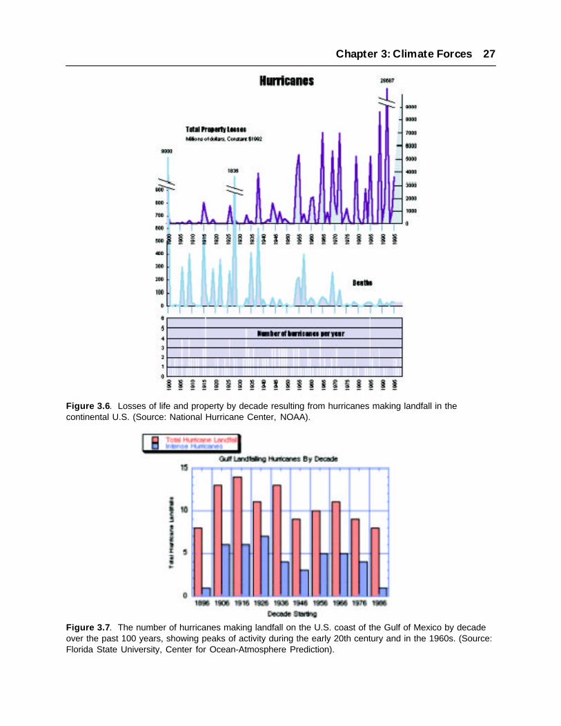
Chapter 3: Climate Forces 27
Figure 3.6. Losses of life and property by decade resulting from hurricanes making landfall in thecontinental U.S. (Source: National Hurricane Center, NOAA).
Figure 3.7. The number of hurricanes making landfall on the U.S. coast of the Gulf of Mexico by decadeover the past 100 years, showing peaks of activity during the early 20th century and in the 1960s. (Source:Florida State University, Center for Ocean-Atmosphere Prediction).

rainfall in West Africa, where greater rainfall corresponds with a greater number of major hurricanes(Landsea and Gray 1992), although the mechanism is not fully understood. The mid-1990’s hasseen a recurrence of large numbers of hurricanes in the north Atlantic Basin suggesting a return toa more active hurricane regime (Landsea et al. 1996).
Extratropical storms and hurricanes, when considered together, also have extreme year-to-yearand decadal variability. A study of 75 to 85 year-long storm surge records derived from tidegauges at Atlantic City, NJ and Charleston, SC found annual differences in the number of eventsof 50% and interdecadal variability of 10-20% (Zhang et al. 1997). However, significant long-term trends were not found either in storm frequency or severity. The records included bothextratropical storms and hurricanes, but were dominated by more frequent extratropical storms.More importantly, the supposition of storm surges on a rising sea-level (3.9 mm/year at AtlanticCity) has resulted in an increase of storm impact over the record length. For example, the numberof hours of extreme storm surges per year has increased from less than 200 in the early 1900’s toan extreme of over 1200 (more typically 600) hours in the past decade.
3.3.2 Future Trends
Prediction of the future intensity and frequency of tropical cyclones has been limited by the coarseresolution of global climate models. However, some progress has been made in estimating futuremaximum potential intensities of cyclones based on thermodynamic considerations (Holland 1997).The basic premise of this work is that maximum cyclone intensity is limited by the availableenergy in the atmosphere and ocean. Such analyses suggest that cyclone intensities will eitherremain near current levels or increase by 10-20%. However, these projected increases may beoverestimated because other factors not included in these analyses, such as ocean spray, tend tolimit intensity.
Recently, the relationship between typhoon intensity and climate change was investigated for thenorthwest Pacific with a regional, high resolution hurricane prediction model (Knutson et al. 1998;Knutson and Tulyea 1999). For a sea-surface warming of 2.2 °C, the simulation yielded stormsthat were more intense, showing a 5 to 12% increase in wind speed. For a moderate typhoon, theseincreases in wind speed translate to increases of 11 to 25% in the destructive power of winds.Similar percentage increases would be expected for other factors determining storm impact suchas wave height and storm surge. Further, the simulation predicts large increases in rainfall, 28%greater than present.
A review of the linkages between tropical cyclones and climate change concluded that the broadgeographic areas where cyclones are generated, and therefore the areas impacted, are not expectedto change significantly (Henderson-Sellers et al. 1998). Limited evidence suggests that there willbe little change in global frequency of cyclones, although regional and local variability couldchange significantly depending upon a variety of phenomena (Meehl et al. 2000).
28 The Potential Consequences of Climate Variability and Change

Pacific tropical cyclones generally develop over ocean water that exceeds 28 to 29 °C. During thepast 30 years such warm water has generally been limited to the western tropical Pacific, whichhas been the region of origin of most of the cyclone activity. However, during El Niño, this regionextends farther east than usual, posing the cyclone threat to islands farther east. The cyclonesnormally develop somewhat north or south of the equator and to the west of the date line, andinitially move toward the west with the trade winds. They then curve poleward and then finallyeastward, threatening islands well off the equator such as Guam, the Marshall Islands, or Hawaii.With global change, this region of warm water is expected to migrate farther toward the east intoareas that now experience warm water only during El Niño events. The expected result is a gradualincrease in the frequency of tropical cyclones for islands in the central and east-central Pacific,both north and south of the equator. Storm frequencies for the western Pacific may not decrease asthey would presently during El Niño events. In fact, they may increase because the SST there willalso be increasing. The overall result, then, will be an eastward extension of the tropical regionthat may normally experience cyclones, especially during the local summer and fall seasons whencyclones are most likely.
For example, recent global climate model investigations have shown that ENSO frequency andintensity may increase with increasing greenhouse gas concentrations. Timmerman et al. (1999),using a GCM with sufficient resolution, found that the tropical Pacific may change to a statesimilar to present day El Niño conditions. Since fewer hurricanes occur in the Atlantic during ElNiño years, this result suggests that hurricanes may decrease in occurrence in the future. Duringsevere El Niño events such as 1982-83 and 1997-98, the jet stream over the north Pacific broughtwinter storms more to the south causing extensive coastal erosion and flooding in California.Hence, a prolonged El Niño state may decrease the occurrence of hurricanes in the Atlantic, butlead to enhanced coastal impacts by extratropical storms along the West Coast. On the other hand,the results of Timmerman et al. (1999) also suggest stronger interannual variability, with relativelystrong cold (La Niña) events becoming more frequent. Although these La Niña events would besuperimposed upon a higher mean temperature, this could suggest more interannual variability in Atlantichurricanes with more intense activity during the stronger cold events.
3.3.3 Implications
Even if storm magnitudes and frequencies of occurrence remain the same, an important impact offuture storms, whether tropical or extratropical, may be their superposition on a rising sea-level.As a result of the higher reach of waves on the beaches and barrier islands of the nation’s coast,flooding and erosion damage will be expected to increase (Ruggiero et al. 1996; Sallenger, inpress; Heinz Center 2000). Such effects will be particularly exacerbated on coasts with relativelylow relief compared to the storm wave runup. However, such effects will not be limited solely tothe low relief coasts of the U.S., such as the barrier islands of the southeast. Even the steep terrainof the West Coast is likely to be affected. For example, during both the 1982-82 and the 1997-98El Niño events, elevated sea-levels of a few tens of centimeters in the Pacific Northwest weresufficient to force wave runup to impact and erode coastal cliffs, causing widespread propertylosses and damages (Komar 1986; Komar 1998).
Chapter 3: Climate Forces 29

3.4 PRECIPITATION AND FRESHWATER RUNOFF
In contrast to a relatively high degree of confidence associated with the increases in globaltemperature that are associated with global change, the effects upon hydrological cycles areconsiderably less certain, particularly on regional scales. The scenarios generated by the Canadianand Hadley models in particular are often contradictory as to trend (Felzer and Heard 1999).Generally, the consensus is that under most climate change scenarios, the hydrologic cycle willbecome more intense (Houghton et al. 1996; Houghton 1997). However altered precipitationpatterns may vary greatly on regional scales. The Water Sector of the National Assessment hasinvestigated this issue in detail, and the results of that assessment should be referred to for acomprehensive review.
Freshwater runoff affects coastal ecosystems and communities in many ways. The delivery ofsediment, nutrients and contaminants is closely linked to both the strength and timing of freshwaterrunoff. Salinity gradients are driven by freshwater inputs into estuaries and coastal systems, andhave strong effects on biotic distributions, life histories and geochemistry. Coastal runoff alsoaffects circulation in estuaries and continental shelf areas; and increases in runoff have the potentialto increase the vertical stratification and decrease the rate of thermohaline circulation by addingmore fresh water to the system.
Extreme rainfall events, already demonstrated to have increased over the last century, are likely tobecome more common, as may droughts and floods (Karl and Knight 1998; Karl et al. 1995). Theaverage precipitation will increase especially at high latitudes, and there are likely to be moreperiods of high precipitation. There might also be regions where the precipitation will decrease.However, under warmer climatic conditions increased precipitation may not result in a directincrease of freshwater inflow into coastal regions, depending on timing of the precipitation andchanges in evapotransporation. Changes in freshwater runoff will also result both from climate-related factors and changes in human population, land-use, and consumption and diversion(Vörösmarty et al. 2000).
In the event that climate change results in increased river flows, more suspended sediments couldbe transported into the coastal regions, increasing the upper layer turbidity and potentially reducingavailable light to both plankton and submerged aquatic vegetation. Changes in sediment transportcould also alter the amount of sediment available for soil aggradation (accumulation) in wetlandsand sands for littoral systems. Increased sediment transport may be beneficial to many coastalareas, providing needed material for accretion to coastal wetlands threatened by sea-level rise,whereas a decrease in sediment transport might concurrently diminish the ability of some wetlandsto respond to sea-level rise. On the other hand, other coastal ecosystems may benefit from reducedsediment inputs, which decrease water clarity or result in rapid infilling.
Increased river flows could also increase the flux of nutrients and contaminants into coastal systems,which influence eutrophication and the accumulation of toxins in marine sediments and livingresources. Both increased temperatures and decreased densities in the upper layers might also
30 The Potential Consequences of Climate Variability and Change

reduce the vertical convection enough to prevent oxygenation of the bottom waters, furthercontributing to anoxic conditions in the near-bottom waters (JustiÉ et al. 1997; Najjar et al. 2000).Decreased freshwater inflows into coastal ecosystems may have the reverse effects to thosedescribed above; reducing flushing in estuaries and increasing the salinity of brackish waters.
3.4.1 Changes in Coastal Runoff
Wolock and McCabe (1999) estimated the potential effects of climate change on mean annualrunoff for U.S. rivers based on Canadian and Hadley model projections and a simple water balancemodel (Figure 3.8). They found that estimates based on the two models differed greatly, with theCanadian model often predicting reduced runoff and the Hadley model predicting increased runoff.Runoff aggregated for Atlantic coast drainage basins was projected to increase by 60% for theHadley model, but decrease by 80% for the Canadian model by the end of the century. Because ofthese differences and because changes in mean annual runoff in individual hydrologic units weremostly smaller than decade-to-decade variability Wolock and McCabe cautioned that these estimatesare uncertain and unreliable. Also, the simple water balance model they used underestimates runoffresulting from highly episodic rainfall in relatively arid areas. Nonetheless, both models projectedlarge increases in precipitation throughout the southwestern U.S., particularly Southern California,where increases in winter precipitation are affected by shifts in the jet stream. These would resultin multifold increases in freshwater runoff to the coastal ocean based on Wolock and McCabe’sestimates.
For most of the Atlantic seaboard, it is uncertain as to whether there will be enhanced or diminishedrunoff. For example, the Canadian model suggests decreased precipitation during the winter forthe Hudson, Delaware and Chesapeake watersheds, and significantly decreased precipitation duringall seasons for the Albemarle-Pamlico watershed. The Canadian model also predicts decreases in
Chapter 3: Climate Forces 31
Figure 3.8. Projected changes in average annual runoff for basins draining to coastal regions of theconterminous U.S. estimated from precipitation and temperature projections of the Canadian and HadleyCenter GCMs (from Wolock and McCabe, 1999).
precipitation in the summer and fall for the northern watersheds during the middle part of the 21s t
century. The Hadley Centre model shows no such inter-regional pattern, and generally suggestslarger general increases in precipitation throughout the Atlantic seaboard. Hence, the coastalresponses are uncertain too. For the Gulf Coast, Wolock and McCabe (1999) suggest, with a fewexceptions, diminished freshwater runoff. Decreases of up to 100% are possible in this region,with those associated with the Canadian model being larger than those from the Hadley model.Once again, the Hadley model diverged and indicated that there could be some runoff increases inthe 2090-2099 period. With a diminished freshwater influx, the westward flowing coastal currentalong the Louisiana-Texas coast would likely decrease. The vertical stratification would diminish,making wind mixing more effective. This could reduce the surface temperature since surfaceheating can be distributed to a greater depth.
For the Pacific coast, both climate model models suggest increases in the runoff, especially insouthern California. Results indicate that there will be an increase in the number of storm eventsentering the U.S. from the Pacific, due to a deepened and southward-shifted Aleutian Low and asouthward-shifted jet stream (Felzer and Heard 1999; Felzer 1999; Sousounis 2000). There willbe enhanced heating at higher latitudes in the lower troposphere, reducing the meridionaltemperature gradients leading to fewer storms globally, but the increase latent heat fluxes in thetropics increases the intensity of storm events (Carnell and Senior 1998; Lambert 1995). However,as demonstrated by the increased frequency of Pacific storms, regional patterns will often varyfrom this global generalization.
Changes in freshwater discharges to the coast are of particular concern in those estuarineenvironments that have already experienced reductions in flows due to water use and diversiondue to human activities. These include such systems as San Francisco Bay (see box), Texas lagoonssuch as Corpus Christi Bay, Apalachicola Bay, and Florida Bay. These estuaries have alreadybeen affected by reduced flows as a result of irrigation, other consumptive water uses, and diversionsout of the basins for drainage, flood protection and water supply. While climate models projectpossible increases in precipitation in the catchment of San Francisco Bay (Wolock and McCabe1999), thus potentially allowing an increase in flows allowed to the estuary, changes in the timingof precipitation and runoff complicate the matter. Both the Canadian and Hadley models predictdecreased precipitation in Texas Gulf region and South Florida (NAST 2000), which would resultin decreased runoff (Wolock and McCabe 1999). This plus growth in population and consumptivewater uses and saline encroachment due to sea-level rise will likely present a particular challengeto efforts to restore the Everglades and mitigate hypersalinity in Florida Bay.
Case Study: Freshwater Flows to the San Francisco Bay/Delta Estuary
The San Francisco Bay and the Sacramento/San Joaquin Delta region comprise one of theUnited States’ most significant and highly studied estuarine systems. This system has a surfacearea of nearly 1000 square kilometers (400 square miles), a length of over 100 kilometers (60miles) and it is the focus of one of the largest population centers in the United States. Likemany estuaries, San Francisco Bay supports a complex and delicate variety of ecosystems,
32 The Potential Consequences of Climate Variability and Change

while serving as an invaluable resource for the humans who live around it. A significant portionof California’s freshwater supply is diverted from the upstream watershed and from theSacramento/San Joaquin Delta in the upper reaches of the system into the elaborate plumbingsystem that stores and channels the state’s water.
Fishes of high economic importance, as well as hundreds of species of flora and fauna, someof them endangered, depend upon the estuarine ecosystem for their survival. As a balancebetween the land and ocean environments, the estuary is sensitive to changes in both its upstreamwatershed and the outside Pacific Ocean. Already, the Delta and the Bay have been stressed bynumerous impacts, often relating to human activities. The region has also been subject tonumerous ecological insults, including an extraordinary number of invasive species. The Bayand Delta have been described as “the most heavily invaded estuary in the world”, with nearly200 non-native species documented (Cohen and Carlton 1998). In some parts of the estuary,non-native species account for as many as 90% of the species and 97% of the total biomass.
The San Francisco Bay consists of two relatively distinct sub-estuaries, the South Bay and theCentral/North Bays. The Bay’s total volume of about 6.7 cubic kilometers (1.6 cubic miles;Conomos 1979) equals about one-third of the freshwater runoff that enters the Bay annually,mostly through its northern reach at the confluence of the Sacramento and San Joaquin Rivers.The estuary’s sole connection with the open ocean is through the Golden Gate, where relativelyfreshwater flows seaward near the surface and the more saline waters of the Pacific flowlandward through a deep channel. The defining process of the estuarine environment is thismixing of saline ocean water with fresh river water. As sea-level determines the level of theestuary and therefore its horizontal boundaries, the potential for rapid sea-level rise hastremendous implications for the estuary and the humans who depend on it. Freshwater inflowto the estuary, both in terms of its volume as well as its timing, is the other major factor whichdetermines salinity distributions in the Bay/Delta, a factor which is likely be strongly affectedby climate change.
Freshwater Inflow
California receives an annual average of nearly 250 cubic kilometers (60 cubic miles) of freshwater in the form of rain and snow. Of this, about 40% ultimately becomes streamflow in thestate’s river network, most of which culminates at the Delta of the Sacramento and San JoaquinRivers at the head of the San Francisco Bay. This freshwater supply is highly managed toensure adequate supplies throughout the year. While most of this water originates in the northernthird of California, a substantial portion is collected in reservoirs during the rainy season forlater conveyance to the areas of greatest demand in Central and Southern California. Storagecapacity in the Sacramento/San Joaquin drainage amounts to approximately 36 cubic kilometers.
The northern reach receives over 98% of San Francisco Bay’s freshwater input through theDelta of the Sacramento and San Joaquin Rivers. Runoff from winter storms collects overapproximately 150,000 square kilometers (60,000 square miles), an area comprising nearly
Chapter 3: Climate Forces 33
40% of the state of California (Conomos 1979). Sacramento River flow is dominated by directrunoff from storms over the western slopes of the northern Sierra, while San Joaquin Riverflow is primarily due to the melting of accumulated snowpack in the southern Sierra. Thisleads to a difference in the timing of the peak flow in the two rivers. Since the peak in theSacramento River flow is associated with direct runoff from storms, it coincides with thewinter/spring rainy season (Peterson et al. 1995).
The greater elevations of the southern Sierra mean that much of the precipitation there isretained as snowpack until temperatures rise enough for melting to occur, usually in late springand early summer. As this water flows through the valley, some is lost to seepage intounderground reservoirs, some to evaporation, and a large portion is dammed and used formunicipal supplies and irrigation. When the remaining flow reaches the Sacramento/San JoaquinDelta, it is subject to further reductions. The primary diversions are the State Water Projectwhich pumps fresh water from the Delta to supply Southern California with much of its water;the Central Valley Project which supplies water primarily for irrigation; irrigation canals onthe Delta islands; and several local canals providing industrial and municipal supplies.
The high freshwater input from the Delta causes a large along-estuary salinity gradient throughthe North and Central Bays (Conomos 1979). When flows are at their peak, the freshwatersignal overrides the up-estuary salt flux and the entire northern reach rapidly becomes fresher.As flows subside, tidal mixing and estuarine circulation begin to dominate, slowly pushing themore saline water up the estuary. This cyclic tug-of-war between saline and fresh conditionsengenders a gradation of ecosystem types from marine near the Golden Gate to riparian upstreamof the Delta. The actual formation and survival of these ecosystems is influenced and limitedby human development around the estuary, in combination with year-to-year variability in thefreshwater supply. This can be particularly important for the estuary during the dry season,when controlled releases of stored fresh water are used to flush saltwater from the Delta regionand the San Francisco Bay.
Implications of Climate Variability and Change
Variations in the timing and amount of the freshwater supply have significant impact onCalifornia and such effects are harbingers of potential effects of longer-term climate change.Excessive rainfall in a short period can overflow reservoirs and cause severe flooding, as inthe storms of January 1997. Conversely, insufficient total precipitation during a given rainyseason can lead to freshwater shortages later in the year, potentially leading to water rationing,losses of agricultural and hydroelectric power commodities and other statewide impacts. Lowfreshwater flow due to drought and excessive upstream diversions can lead to unnaturallyhigh salinities in the Bay/Delta estuary, potentially contaminating freshwater supplies andadversely impacting the health of the estuarine ecosystem (Jassby et al. 1995).
Interannual and interdecadal variations are also of strong significance. Multi-year events suchas the drought of 1987-1992 have cumulative effects on economies and ecosystems. A multi-year drought or flow abundance can alter salinity, creating conditions unsuitable for existing
34 The Potential Consequences of Climate Variability and Change

estuarine ecosystems. Confounding this situation further is the extensive human developmentaround the Bay/Delta which prevents ecosystems from migrating upstream or downstream tomore suitable salinity regimes, leading to intensified ecosystem degradation or loss.
The potential implications of global warming for freshwater flows in the Bay/Delta watershedare somewhat uncertain. In particular, it is unclear whether overall water supply will increaseor decrease. Several climate models do suggest that precipitation will increase, although muchof this increase is likely to occur in intensive precipitation events resulting from winter storms(see section 3.3). It is also unclear what the overall effect of global change on interannual andinterdecadal variability may be, although it is clear that increased temperatures would lead toa shift of freshwater flows from spring to winter. This is due to the earlier melting of snowpackunder warmer conditions. In fact, this effect has already been observed. A slow rise in wintertemperatures since the 1940’s has led to earlier snowmelt runoff (Dettinger and Cayan 1995),effectively decreasing the natural storage in the Sierra on an interdecadal time scale. This haspartially contributed to an overall rise in Bay/Delta salinities over this period.
If this effect were to strengthen significantly over the next century, the results could be dramatic.Increased winter flows and decreased spring flows would allow contaminants (e.g., pesticides,urban pollutants, etc.) to accumulate more during the longer dry season. When the high winterflows finally arrive, they would flush the system quickly, potentially resulting in a much higherconcentration of pollutants which could damage ecosystems and contaminate freshwatersupplies. Additionally, the decreased natural storage would make repulsion of saline watersfrom freshwater pumping sites more difficult, as freshwater supplies during the dry seasonwould be considerably reduced.
Finally, a shift toward earlier flows would result in much fresher salinity distributions in thewet season and much more saline waters in the dry season. This change in the estuarine salinityenvironments would have significant effects on all estuarine ecosystems, though the details ofsuch changes are as yet poorly understood. Freshwater flows would arrive earlier due todecreased snow accumulation, likely resulting in increased concentrations of harmfulcontaminants and in a significantly changed seasonal salinity cycle in the estuary. The effectsof these changes on estuarine ecosystems are uncertain but are likely to be adverse, furtherstressing an ecosystem which is already heavily impacted by a wide range of environmentalproblems (Field et al. 1999). Additionally, the significance of water diversions and the ongoinginability of water managers to fully address the needs for freshwater delivery to the to the Bayremains a major problem that is likely to be further exacerbated by future changes in precipitationpatterns and timing.
3.5 SEA-LEVEL CHANGE
Coastal water levels rise and fall on various time scales. Tides resulting from the gravitationalattraction of the sun and moon cause water levels to rise and fall daily anywhere from a few
Chapter 3: Climate Forces 35

centimeters in some estuaries to four meters along the Gulf of Maine. The amplitude of the dailytide fluctuates by about one-third twice each lunar month, according to whether the solar andlunar tides are in phase with each other. Storm surges, winds, currents, rainfall and other factorscan also affect water levels on short time scales. These effects are significant because many of theexpected impacts associated with sea-level rise are the result of the increase in the baseline sea-level for storm surges and flooding events, rather than direct effects of sea-level rise itself.
Generally, sea-level refers to the average water level over the course of a 20-year period, which isenough time for astronomic and most climatic fluctuations to run through their complete cycles(such as the cycling of Perigean spring tides; see Wood 1986). Over geological time scales however,sea-level has fluctuated greatly. During the Cretaceous Period, over 100 million years ago, sea-level was as much as 350 meters above present levels (Emery and Aubrey 1991), correspondingwith a time of rapid seafloor spreading, an ocean between 10 and 15°C warmer than today’s, anda warmer atmosphere with little or no landlocked ice. More recently, sea-level has risen and fallenwith the 100,000-year glacial-interglacial cycle. During glacial periods, sea-level has been asmuch as 120 meters (nearly 400 feet) lower than current levels (Fairbanks 1989), whereas duringthe warmer interglacial periods, sea-level has been as much as 5 to 7 meters (about 20 feet) higherthan the present.
On average, global sea-levels have been gradually rising since the conclusion of the last ice ageapproximately 15,000 years ago; although rates over the last 6,000 years have fluctuated somewhat.During the last 100 years, sea-level rise has occurred at a rate of approximately 1 to 2 millimeterper year, or 10 to 20 centimeters (4 to 8 inches) per century, according to most estimates (Gornitz1995; IPCC 1996). This refers to the eustatic sea-level, the absolute elevation of the earth’s ocean,which has been determined from tidal stations around the globe. However, there are large regionalvariations due to subsidence, isostatic (glacial) rebound, tectonic uplift, and other factors thatcontribute to a “relative” sea-level rise which usually differs from the global average. While somelong-term tide-gauge records suggest that there may have been a slight increase in the rate of sea-level rise observed over the last century, efforts to verify this (Douglas 1992) have generally beenunable to confirm a significant acceleration.
3.5.1 Primary Causes of Sea-level Change
Most of the sea-level change observed over the last several hundred thousand years is accountedfor by two major variables; the thermal expansion or contraction of the oceans (steric effects) andthe amount of water that is locked up in glaciers and ice sheets. The thermal component resultsfrom expansion and contraction of the volume of the ocean associated with changes in meanocean temperatures; given an equal mass the total volume decreases when ocean temperaturesdrop, and expands when temperatures increase. Gornitz (1995) reviewed a number of assessmentsof estimated contributions to sea-level rise, which generally suggested that the majority of sea-level rise anticipated over the next century is likely to result from thermal expansion of the oceans.
The second major variable with regard to current and future sea-level is the contribution to thevolume of the oceans from water formerly locked up in glaciers and ice caps. Current major
36 The Potential Consequences of Climate Variability and Change

glaciers and ice sheets account for enough mass to raise global sea-level by approximately 80meters (250 feet), if all were to melt and flow to the sea (Emery and Aubrey 1991). Over the lastcentury, there has been an observed increase in the thinning of glaciers in many parts of the world,including the Alps, many parts of Alaska and many regions in the Andes (IPCC 1996). While thisglacial melt has played a role in the sea-level rise observed over the last century (and expectedover the next century), the vast majority of landlocked ice is to be found in Antarctic and Greenlandice sheets. Both of these have contributed substantially to observed sea-level rise since the lastinterglacial (Cuffey and Marshall 2000). It is difficult to estimate the contribution of melting ofthese ice sheets to sea-level rise over the next century, however recent evidence of thinning of theperiphery of the Greenland Ice Sheet suggests it may already be contributing 0.03mm/year (Krabillet al. 2000).
In particular, there is a great deal of concern about the stability of the West Antarctic Ice Sheet(WAIS). This ice sheet, as opposed to most glaciers, other Antarctic ice sheets and the Greenlandice sheet, is not landlocked but rather rests on the continental shelf below sea-level in the Weddell,Bellingshausen and Ross Seas. While the melting of Arctic sea ice will have essentially no impacton global sea-levels, because this ice is already displacing its own mass by floating on the ocean,the grounded ice sheets in Antarctica have the potential to dramatically affect sea-level throughmelting and/or wasting. Altogether, the WAIS contains enough ice to raise global sea-levels byfour to six meters (13 to 20 feet). Concerns for the stability of the WAIS have been raised repeatedly,in part due to the continued disintegration of some smaller ice shelves fringing the AntarcticPeninsula. Oppenheimer (1998) reviewed evidence of global warming and the stability of theWAIS and generally suggested that the probability of mass wasting of the WAIS, followed by asignificant increase in sea-level, during the next 100 years was relatively low. However, he alsofound that the probability of a major rise in sea-level due to melting or wasting of the WAIS wassubstantially greater after 2100.
Additionally, anthropogenic alteration of hydrological cycles through groundwater mining, waterstorage, and other processes could also influence future sea-levels. Activities such as groundwatermining, deforestation and water released from the combustion of fossil fuels would have the effectof slightly increasing global sea-level. However the storage of water behind dams andimpoundments, and the losses of water due to infiltration beneath impoundments and irrigatedcroplands, would reduce the total flux of water to the oceans. Gornitz et al. (1997) reviewed recentstudies of human-induced alterations of land hydrology and suggested that a preliminary estimateof the net effect of these activities could be sufficient to reduce sea-level rise by 0.8 millimetersper year; or 8 centimeters (3 inches) per century, with a range of 4 to 12 centimeters (1.5 to 5inches) per century.
Finally, there are significant regional components to sea-level change. The term “relative sea-level rise” refers to the change in sea-level compared with land elevation at a particular location.As Figure 3.9 shows, the rate of relative sea-level change varies considerably along the U.S. coast,largely because of land movements caused by isostatic rebound, subsidence, compaction and settlingdue to alluvial deposition in deltas, subsidence from extraction of water and petroleum, and tectonic
Chapter 3: Climate Forces 37
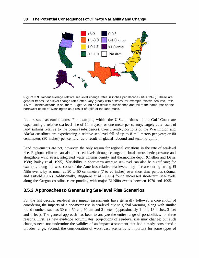
factors such as earthquakes. For example, within the U.S., portions of the Gulf Coast areexperiencing a relative sea-level rise of 10mm/year, or one meter per century, largely as a result ofland sinking relative to the ocean (subsidence). Concurrently, portions of the Washington andAlaska coastlines are experiencing a relative sea-level fall of up to 8 millimeters per year; or 80centimeters (30 inches) per century, as a result of glacial rebound and tectonic uplift.
Land movements are not, however, the only reason for regional variations in the rate of sea-levelrise. Regional climate can also alter sea-levels through changes in local atmospheric pressure andalongshore wind stress, integrated water column density and thermocline depth (Chelton and Davis1980; Bailey et al. 1995). Variability in short-term average sea-level can also be significant; forexample, along the west coast of the Americas relative sea levels may increase during strong ElNiño events by as much as 20 to 50 centimeters (7 to 20 inches) over short time periods (Komarand Enfield 1987). Additionally, Ruggiero et al. (1996) found increased short-term sea-levelsalong the Oregon coastline corresponding with major El Niño events between 1970 and 1995.
3.5.2 Approaches to Generating Sea-level Rise Scenarios
For the last decade, sea-level rise impact assessments have generally followed a convention ofconsidering the impacts of a one-meter rise in sea-level due to global warming, along with similarround numbers such as 30 cm, 50 cm, 60 cm and 2 meters (approximately 1 foot, 18 inches, 3 feetand 6 feet). The general approach has been to analyze the entire range of possibilities, for threereasons. First, as new evidence accumulates, projections of sea-level rise may change; but suchchanges need not undermine the validity of an impact assessment that had already considered abroader range. Second, the consideration of worst-case scenarios is important for some types of
38 The Potential Consequences of Climate Variability and Change
Figure 3.9. Recent average relative sea-level change rates in inches per decade (Titus 1998). These aregeneral trends. Sea-level change rates often vary greatly within states, for example relative sea level rose1.5 to 2 inches/decade in southern Puget Sound as a result of subsidence and fell at the same rate on thenorthwest coast of Washington as a result of uplift of the land mass.

Chapter 3: Climate Forces 39
risk assessment, where events with small probability but high impact may have a great impact ondefining the most rational course of action. Finally, most studies suggest that sea-level may continueto rise at an accelerated rate for a few centuries, so the sea may reach a level that is unlikely within50-100 years during subsequent centuries.
General Circulation Models do provide credible estimates of sea-level rise due to thermal expansion,glacial melt and historic rates of sea-level change, including regional variability in eustatic sea-level resulting from oceanographic and atmospheric conditions. However, these outputs need tobe adjusted for regional land movements before effective regional assessments can be performed.Figure 3.10 shows historic and future sea-level rise scenarios for the Canadian and Hadley modelsbetween 1900 and 2100. Both models suggest a mean expected sea-level rise of approximately 45to 51 centimeters (18 to 20 inches) above current levels by the end of the century. Figure 3.11 alsoshows regional Canadian and Hadley climate model outputs for sea-level change around the year2090, in which significant differences exist between the East and West coasts due to changes inoceanographic and atmospheric conditions. In general, the Hadley model predicts a greater sea-level rise for the Pacific coast than for the Atlantic and Gulf coasts as a result of altered currentand wind patterns. By contrast, the Canadian model predicts a more complex pattern of sea-levelrise, but with relatively similar increases along all U.S. coasts.
Figure 3.10. Reconstructions (over the past 100 years) and projections (over the next 100 years) of globalsea level from the Hadley Climate Centre and Canadian Climate Center General Circulation Models.Hadley model simulations include the effects of glacial melting as well as thermal expansion of the ocean,while the Canadian model considers only thermal expansion.
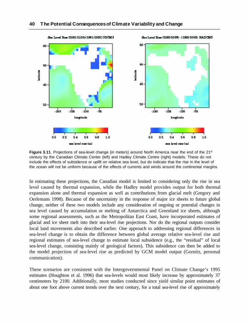
In estimating these projections, the Canadian model is limited to considering only the rise in sealevel caused by thermal expansion, while the Hadley model provides output for both thermalexpansion alone and thermal expansion as well as contributions from glacial melt (Gregory andOerlemans 1998). Because of the uncertainty in the response of major ice sheets to future globalchange, neither of these two models include any consideration of ongoing or potential changes insea level caused by accumulation or melting of Antarctica and Greenland ice sheets, althoughsome regional assessments, such as the Metropolitan East Coast, have incorporated estimates ofglacial and ice sheet melt into their sea-level rise projections. Nor do the regional outputs considerlocal land movements also described earlier. One approach to addressing regional differences insea-level change is to obtain the difference between global average relative sea-level rise andregional estimates of sea-level change to estimate local subsidence (e.g., the “residual” of localsea-level change, consisting mainly of geological factors). This subsidence can then be added tothe model projection of sea-level rise as predicted by GCM model output (Gornitz, personalcommunication).
These scenarios are consistent with the Intergovernmental Panel on Climate Change’s 1995estimates (Houghton et al. 1996) that sea-levels would most likely increase by approximately 37centimeters by 2100. Additionally, most studies conducted since yield similar point estimates ofabout one foot above current trends over the next century, for a total sea-level rise of approximately
Figure 3.11. Projections of sea-level change (in meters) around North America near the end of the 21st
century by the Canadian Climate Center (left) and Hadley Climate Centre (right) models. These do notinclude the effects of subsidence or uplift on relative sea level, but do indicate that the rise in the level ofthe ocean will not be uniform because of the effects of currents and winds around the continental margins.
40 The Potential Consequences of Climate Variability and Change

45 to 52 centimeters (18 to 20 inches) above their current level by the year 2100 (Titus andNarayanan 1996; Wigley 1999). It is also generally agreed that sea-level rise will continue toaccelerate beyond 2100, as a result of the long time frame necessary for oceans and ice sheets toapproach equilibrium. Finally, the rate of sea-level rise may be as important as the absolute risefor some key natural processes, such as the ability of wetlands to keep pace with sea-level change.The available studies suggest that the rate of sea-level rise by the year 2100 is unlikely to besubstantially greater than the average rate between now and the year 2100, except in the worstcase scenario where the rate could be about twice as great.
Case Study: Sea-Level Rise and Migratory Shorebirds
Shorebirds undertake twice yearly migrations that are among the longest known among anyanimal species. In the Americas, these may involve annual journeys of up to 18,000 milesbetween their breeding areas in the high arctic and their wintering areas in the southernmostparts of South America. These long-range migrations are energetically costly, thus shorebirdsrequire a series of coastal “staging” sites where they can rest and replenish their fat reserves,the main fuel for long distance migration (Blem 1980; Evans and Davidson 1990). Duringtheir stopovers, individuals of some shorebird species may double their weights in a few daysto accumulate enough fat to fuel their flight to the next staging site (Myers 1983; Burger andOlla 1984). Such weight gains are only possible at sites where extremely rich food supplies arereadily available. Thus, the availability of staging sites with rich and accessible food suppliesis a critical factor in a species’ migration schedule and the elimination of any one importantsite could potentially undermine the feasibility of the entire flyway strategy.
The international conservation importance of two of these sites, Delaware Bay in Delawareand New Jersey, and Bolinas Lagoon in California, is reflected in the fact that they have beendeclared “Wetlands of International Importance” under the Ramsar IntergovernmentalConvention (Smart 1987). San Francisco Bay, California, has also been nominated for Ramsarlisting as an internationally important wetland. This reflects not only the importance of thesesites for shorebirds, but also the existence of threats to their long-term survival. In the past,shorebird habitat at coastal sites has been lost largely due to reclamation (Evans 1997; Goss-Custard and Moser 1988). More recently, a new threat to shorebird staging sites has beenrecognized, habitat loss due to sea-level rise caused by global climate change (Ens et al. 1995;Evans 1991; Markham 1996).
Systematic survey data have shown that five sites in the U.S. are extremely important in termsof the numbers of shorebirds that they support. These include San Francisco, Humboldt, andWillapa Bays on the Pacific coast; Bolivar Flats on the Gulf of Mexico coast, and DelawareBay on the Atlantic coast. Information on the numbers of birds using these sites was obtainedfrom two long-term surveys: the International Shorebird Survey (the East Coast sites) and thePacific Flyway Project. The current distribution and extent of shorebird intertidal feedinghabitat (mud and sand flats) was obtained from the National Wetlands Inventory database.Probabilistic local sea-level rise scenarios for each of these sites were obtained from studiescarried out by the USEPA (1995).
Chapter 3: Climate Forces 41

42 The Potential Consequences of Climate Variability and Change
Figure 3.12. Scenarios for the rates and extent of sea-level change for Willapa Bay (A) and South SanFrancisco Bay (B) based on the Sea Level Affecting Marshes Model (SLAMM4).
The likely effects of three sea-level rise scenarios on the extent of intertidal shorebird habitatat each of the sites were estimated using the most recent (4th) version of the Sea-level AffectingMarshes Model (SLAMM 4). Preliminary results of this study are showing that the extent ofhabitat loss is likely to vary greatly between sites depending on the sea-level rise scenario, butalso on local factors, such as rates of land subsidence or uplift. These patterns are illustratedbelow by comparing the results from two sites on the Pacific coast; Willapa and South SanFrancisco Bays. Figures 3.12 shows the rates and extents of relative sea-level change projectedfor these two sites. The historic scenarios are based on empirical data from tide gauges at thetwo sites, and do not include any acceleration in sea-level change. The 50% probability scenariois based on a global sea-level rise of 34 cm, a level consistent with those currently projected bythe Canadian or Hadley models.
The results generated by the SLAMM model show that under historic rates of local sea-levelrise, Willapa Bay is likely to lose very little intertidal flats and to gain a relatively small amountof saltmarsh by the years 2100 and 2200. In contrast, the model indicates that South SanFrancisco Bay will lose approximately 70% of its tidal flats by 2200. When we factor in the50% probability scenario, Willapa Bay could lose approximately 30% of its tidal flats by2200, while South San Francisco Bay could lose virtually all of its mud and sand flats in thenext two centuries. The predictions for Willapa Bay and South San Francisco Bay differ somarkedly because of local differences in crustal movements and their effects on local sea-level change. At Willapa Bay the land surface is slowly rising due primarily to isostatic rebound.This uplift reduces the potential for inundation of tidal flats. However, at South San Francisco

Chapter 3: Climate Forces 43
Bay, the land surface has been subsiding due to depletion of the local aquifer and, perhaps,tectonic movements. The net results of this is that local sea-level rise at South San FranciscoBay has been rapid.
Studies at other sites show that the two sites likely to be most severely affected by sea-levelrise are San Francisco Bay and Delaware Bay. While it is difficult to assign likely numericalresponses between habitat loss and shorebird populations, the projected extents of habitat lossat these two sites under the 50% probability scenario warrant serious concern. Clearly, underthis scenario future sea-level rise will likely have serious effects on the ability of many coastalwetlands to support populations of migratory birds that depend on intertidal feeding habitats.However, important questions remain unanswered, particularly regarding the effects of humanresponses to sea-level rise. For example, the installation of extensive coastal protection structureswith a concomitant reduction in the ability of the coastal site to migrate inland could exacerbatethe effects of sea-level rise. Also significant is that the severity of effects will likely varywidely between sites. However, it is not known what effect the virtual removal of one or moreimportant sites on a flyway might have if accompanied with only minor effect on others.

Chapter 4
Impacts to Coastal and MarineEnvironments
Globally, few environments on the earth are as biologically diverse and productive as those foundin coastal areas and ocean margins. Marine ecosystems are currently thought to contain aboutone-fifth of all known species, although there remain numerous undescribed species and evenecosystems in the deep sea and in polar regions which have scarcely been sampled. Hundreds ofnew species are described almost annually, from habitats previously poorly or not at all known toscience; including hydrothermal vent communities and whale carcasses (NRC 1996a). All but oneanimal phylum occurs in the marine environment, while only about half of the known phyla occuron land.
As alluded to in the opening of this assessment, most of these systems have already been moderatelyto severely affected by anthropogenic activities. Changes in the range and abundance of nativespecies as associated with climate change will further intensify the impacts to the function andbiodiversity of coastal and marine ecosystems (Reid and Trexler 1992, Mathews-Amos and Berntson1999). As these system provide substantial goods and services to both human welfare and planetaryprocesses as a whole, their continued ability to function is critical. Natural systems, such as tidalwetlands, can provide flood control, storm protection, and waste recycling and thus have tremendousvalue when measured economically. However, estimating the effects on such resources are difficultto quantify because they lie outside the traditional market and have only rarely been thoroughlymeasured. Despite this, Costanza et al. (1997; discussed in section 2.2) have used a number ofpublished studies to summarize the value of earth systems economically. Their work suggests thatcoastal and marine environments constitute over half of the total value of the natural environmentsecological services.
The number and diversity of biogeographic biomes, realms and provinces in the marine and coastalenvironment is enormous, as many as 21 oceanic and coastal margin realms and 45 coastal provinceshave been described (Ray et al. 1992). However we have greatly simplified ecosystem descriptionsfor the purposes of this assessment. Additionally, we have attempted to be highly inclusive ofhuman settlement and activities in these systems, particularly in the section discussing shorelinesand coastal developed areas. Thus, five principal ecosystem types were evaluated for thisassessment; shorelines and coastal communities, estuaries, coastal wetlands, coral reefs, and oceanmargins/marine fisheries. This breakdown provides some means for understanding what may bethe most significant impacts on broad ecological systems, and individual case studies providespecific examples of the complex set of interactions between the effects of climate and humanactivities.

46 The Potential Consequences of Climate Variability and Change
4.1 SHORELINES AND COASTAL DEVELOPED AREAS
Diverse and complex natural processes continually change shoreline systems (the beach, shoreline,and nearshore) physically, chemically, and biologically, at scales that range from the micro andmacroscopic (sand-grains and seconds) to global and long term (sea-level rise). Regional andlocal characteristics of shoreline systems define the differing interactions and relative importanceof these natural processes. Human activity may also add another dimension to change byexacerbating and attenuating, both directly and indirectly, natural processes. Individually, eachprocess is complex but taken collectively, they create an extraordinarily intricate system thatconstantly attempts to achieve a dynamic balance between force and response.
Coastal erosion is already a widespread problem in the U.S., and to varying degrees all coastalstates are subject to hazards relating to erosion somewhere along their coastlines. For example,over the past 50 years in Oahu, Hawaii, a quarter of the beaches have been lost or significantly
Figure 4.1. Classification of the rate of shoreline erosion throughout the United States (after Dolan et al.1985).
degraded due to causes that are poorly understood. Generally, the highest-risk areas are thosecurrently experiencing rapid erosion rates and with very low relief, such as the southeastern UnitedStates and the Gulf Coast. Figure 4.1 shows some of these areas, although the scale and detail inthis figure is extremely coarse and finer scale resolution is necessary for understanding true regionalvulnerability.

Chapter 4: Impacts to Coastal and Marine Environments 47
Sea-level rise is one of the most significant threats to shoreline systems, by increasing thevulnerability of developed shorelines and floodplains through the elevation of the baseline waterlevel for extreme storms and coastal flooding events. However, it is important to recognize thatthese impacts are largely associated with human settlements and developed areas. In general mostunaltered and naturally functioning shorelines are capable of adapting or responding to sea-levelrise, storm surges and wave impacts, and other climate related phenomena.Storms and hurricanes are the most visible and costly direct manifestations of climate to shorelines,and particularly developed areas. As discussed, earlier hurricanes and extratropical storms haveresulted in enormous economic impacts extending into billions of dollars in insured losses alone.
Assessing the full costs of such disasters is difficult; recent studies have suggested that in manyinstances the reported costs of coastal hazards and disasters are significantly under-reported (HeinzCenter 2000). This is because such estimates rarely account for the costs to individuals, familiesand neighborhoods, as well as to natural resources and the environment. As coastal populationincreases, in some states growth projections are as much as 45 to 50% population growth by 2025(see section 2.1), the increases will assuredly be accompanied by new property construction.Subsequently, the economic vulnerability of human developments in coastal areas to hurricaneand storm activity will continue to rise. This will be independent of, although aggravated by, anyclimate induced changes in the frequencies or intensities of these events.
4.1.1 Shoreline Processes
Fluids and sediments within shoreline systems are constantly in motion in response to a variety ofnatural processes. Winds not only move unconsolidated sediments and reshape features along theshoreline, they produce waves that move across the surface of waters until they become unstableover shallow water and steepen and break, dissipating their energy in turbulence and heat. Inmany areas, waves consistently approach the coast at oblique angles. Even the slightest anglebetween the land and the breaking waves will create currents that transport sediment along theshore. These “longshore” currents are a primary cause of sand migration along barrier and mainlandbeaches and are greatly affected by bottom topography (bathymetry). Rivers carry sediment to thecoast and commonly build deltas into the open water, though wave action transports some of thematerial away from the river mouth to other areas. Through this process, sand is added to beachesas natural nourishment. When rivers are damned or where they empty into estuaries, sand generallydoes not nourish coastal beaches, thus contributing to further erosion.
Storms, hurricanes, typhoons, and similarly extreme atmospheric phenomena along coasts producehigh winds which in turn generate large waves and currents. The storms may also produce stormsurges that temporarily raise water levels far above normal. For example, Hurricane Camille, oneof only two Category 5 hurricanes ever to hit the U.S. in recorded history, induced a storm surgealong the Mississippi Coast of as much as 7 meters (24 feet). Although these events are sporadic,they are a primary cause of beach erosion in the U.S. Storm waves eroding the beach usually movemuch of the nearshore and beach sand seaward, where it may be stored in offshore bars or lostfrom the active system when deposited in very deep water. Much of the sand stored in bars migrates
toward shore during calmer weather, contributing to the natural recovery of the beach. Stormsoften display seasonal association, with hurricanes and typhoons occurring in the summer and falland extra-tropical storms occurring predominantly in late fall, winter, and early spring.
Natural processes that change the water level over a long period of time also affect coastal dynamics.Sea-level change is certain to change the nature of the bottom and that affects the shapes of wavesas they approach the coast, and thus may produce changes in local and regional scale sedimentmovement and resulting shoreline morphology. Thus, any climate-induced changes to storm tracks,intensity and duration would be likely to produce significant changes in sediment deposition anderosion patterns.
Tides rise and fall in a matter of hours in response to the gravitational attraction of the moon andsun; exceptionally high (spring) and low (neap) tides occur each month when the sun and moonare aligned. Tides help determine where and when the waves break and where sand is moved fromand to. In addition to the daily cycles of tides, many other forces lead to significant changes inwater level. Tides are important in determining the ultimate impact of a storm. If a storm hits thecoast at high tide, the storm surge is magnified greatly; whereas if a surge hits a coast during lowtide the effect may be negligible. The Great Lakes and other enclosed “seas” also experiencedramatic water level changes in response to precipitation, snowmelt and evaporation. Local changesin water level also occur when the land either rises or falls relative to the water.
Along tectonically active coasts, such as the earthquake prone West Coast of the U.S., land mayrise slowly as much as 4 centimeters (1.5 inches) per century, or may rise or fall dramatically byseveral meters in episodic earthquakes and land movements. In recently abandoned deltas, such asnear the mouth of the Mississippi River, compaction of newly deposited sediment can result inextensive land subsidence of as much as one centimeter per year, or one meter per century. TheEarth’s crust in parts of Alaska and the Great Lakes region are now rising due to the retreat ofglaciers, which many postulate is the result of global warming. However, most of the nation’sbeaches and barrier coasts have already begun responding to natural and possibly climate-inducedrelative sea-level rise, and often reductions in sediment supply as well. Thus, climate change mayresult in processes which counterbalance or accentuate each other, and anticipating the impactsthat humans will have to face must be based on thorough knowledge and understanding of theinteractions between climate forcing and the responses of the earth system.
4.1.2 Potential Impacts of Sea-level Rise
If a one-meter rise in sea level occurs during the next century, the worst-case IPCC scenario,thousands of square kilometers could be lost, particularly in low-lying areas such as the Mississippidelta, where land is also subsiding at approximately one meter per century. Figure 4.2 indicatesseveral estimates of potential land loss for seven regions of the U.S. under several different scenarios,including no change in the current rates of relative sea-level rise, a 50 centimeter (20 inch) increasein sea level, and 1 meter (3 feet) sea level increase over the next century.
48 The Potential Consequences of Climate Variability and Change

Rising sea level will also, in general, increase storm surge flooding both as a result of the highermean water level and because of sea-level rise induced erosion of land forms (Zhang et al. 1997;Ruggiero et al. 1996). Some areas will experience dramatic changes, going from no flooding toextensive flooding. Many coastal features, such as levees, seawalls, and naturally occurring sanddunes and ridge lines effectively block storm surges for most storms. Whenever one of thesefeatures is overtopped by storm surge from either a hurricane or an extratropical storm, the areasinland will flood. Numerical modeling has shown that large amounts of water can move over suchbarriers, flooding over the marshland or bay behind the barrier, and sweeping over mainlandareas. Furthermore, when beaches and dunes are overtopped, there is a net landward transport ofsand contributing to the net erosion of the oceanfront shoreline.
In general, a rise in sea level or changes in storms or storm surges will result in the increasederosion of shores and associated habitat, increased salinity of estuaries and freshwater aquifers,altered tidal ranges in rivers and bays, changes in sediment and nutrient transport, a change in thepattern of chemical and microbiological contamination in coastal areas, and increased coastalflooding. Secondary impacts associated with sea-level rise, such as inundation of waste disposalsites and landfills that will reintroduce toxic materials and increased siltation of subtidal habitatsdue to shoreline erosion, also pose threats to the health of coastal populations and ecosystems.
Many coastal structures were designed with the 100-year flood as their basis. This flooding leveldetermines the elevations to which federal projects, such as the U.S. Army Corps of Engineerslevees that protect New Orleans, are built. This is also the level to which coastal structures must be
Chapter 4: Impacts to Coastal and Marine Environments 49
Figure 4.2. Estimated land loss for seven regions of the U.S. without shoreline protection based onprojections of current rates (baseline) and sea-level rise of 50 cm and 100 cm over this century (after Tituset al. 1991).

built to qualify for flood insurance through FEMA’s National Flood Insurance Program. If sealevel rises, the statistics used to design these structures changes. A 50-year flood may become assevere as (or even more severe than) a 100-year flood before sea-level rise (for a thorough reviewof risk, return times and flooding events, see Pugh and Maul, 1999). Coastal insurance rates wouldhave to be adjusted to reflect such increased risk (Heinz Center 2000). Furthermore, FEMAestimated that the number of households in the coastal floodplain would increase from 2.7 millionto 6.6 million by 2100 (FEMA 1991). This again reiterates the earlier point that the vulnerabilityof coastal developed areas to natural disasters can be expected to increase in the future, independentof any climate induced changes in risk.
Assessing total economic impacts from sea-level rise on coastal areas and on a national scale isstill somewhat speculative. Nevertheless, a recent study (Yohe et al. 1996) has quantified thepresent economic costs (protection plus abandonment) to coastal structures, again using the extreme1-meter sea-level rise as a baseline. This analysis estimated costs of as much as $36 billion between1996 and 2100. However, this number represents market-valued estimates only, which are derivedfrom property-value appreciation, market adaptation, and protection costs. As such, this is anabsolute minimum cost estimate, as it does not include the lost ecosystem services value of non-market resources, or the costs to communities resulting from reductions in coastal economicactivities such as fishing, tourism and recreation. A comprehensive review of the potential cost ofsea-level rise to developed coastlines was recently completed by Neumann et al. (2000); andshould be referred to for more comprehensive estimates.
4.1.3 Shoreline Systems of the West Coast
Mainland shoreline systems of the U.S. West Coast border an active tectonic region of fault-bounded crustal blocks with high elevations. Ancient shoreline terraces hundreds of meters abovepresent sea level are evidence of rapid and extensive crustal uplift along the coasts of SouthernCalifornia. The relatively narrow offshore continental shelf is bordered by deep ocean basins, andin several areas submarine canyons extend almost to the shoreline itself. Eroding headlands andsea cliffs provide much of the sediment to feed adjacent beaches. Rivers too, often fronted byextensive lagoons or bays, have historically provided much of the sediment to the nearshore system.However, extensive damming of streams and rivers for flood control and irrigation has greatlyreduced the volume of material reaching the coast. The mainland beaches are relatively steep,producing a narrow zone where the brunt of the forces generated by breaking waves areconcentrated.
Climate variability, such as the El Niño Southern Oscillation (ENSO), affect the frequency andintensity of storms impacting this narrow zone, with corresponding cycles of beach and cliff erosion.During the 1982-83 and the 1997-98 El Niño events, impacts were especially severe along shorelinesthroughout California, Oregon and Washington (Komar 1998; Kaminsky et al. 1998). Good (1994)shows that along the central Oregon coast, a rapid buildup of seawalls and revetments routinelyfollows the major El Niño events of the last two decades, as coastal property owners attempt toprotect their shorelines from increasing erosion. Sea-level rise would certainly allow these patterns
50 The Potential Consequences of Climate Variability and Change

of erosion to continue, although the magnitude of change will likely be less than in regions withmuch more shallow nearshore slopes. Yet, even relatively small rates of erosion can be hazardouswhen structures have been or are built very close to shorelines.
4.1.4 Barrier Island Systems along the East and Gulf Coasts
The U.S. East and Gulf coasts are rimmed by a series of barrier island/bay systems separating thegently sloping mainland coastal plain from a similarly sloping continental shelf. The waters of thebays or lagoons between the islands and the mainland are mixed with ocean water passing throughtidal inlets and freshwater runoff from the mainland. Most rivers cutting through the low-lyingcoastal plains flow slowly toward the bays and deposit much of their sediment directly into thebays, providing source material for extensive mud flats or marshes. The islands bear the brunt ofwinter storms and hurricanes prevalent along these coasts, protecting the mainland from the verylarge waves characteristic of ocean conditions.
However, with a rising sea level, many of these islands “roll over” or move toward the mainlandthrough a process of beach erosion on their seaward flank, overwash of sediment across the islandand deposition in the quieter waters of the bay. The rates of such natural barrier island movementdepend largely on the rate of sea-level rise, and also on the frequency and severity of storms andhurricanes. Since the slope of these areas is so gentle, a small rise in sea level produces a muchlarger landward translation of the shoreline than occurs on the steeper West Coast. Human activitiescan severely impact this natural landward migration. The construction of buildings, roads, andseawalls disrupts overwash, although storms and sea-level rise continue. In response, the beachfaceand nearshore erode, threatening buildings and narrowing the beach.
Ringing the bays and lagoons of barrier island systems are a variety of salt marshes and otherwetlands which provide critical habitat to a variety of aquatic and terrestrial species. In somecases, such as along the coast of Louisiana, broad expanses of wetlands sheltered from stormwaves have developed. Such ecosystems are particularly at risk from sea-level rise. Wetlandsrequire a delicate balance of sediment, fresh and salt water and are particularly vulnerable toinundation and erosion as a result of sea-level rise.
Case Study: Economic Impacts of Sea-Level Rise
Climate assessments have attempted to estimate the nationwide impacts of climate change onagriculture, forests, water resources, utilities, human health and many other sectors of society.Nationwide assessments of the potential consequences of sea-level rise to the coastal zonehave focused on the extent and magnitude of land loss, the costs to flood insurance and othereconomic impacts. This case study summarizes the results of a number of these earlierassessments on impacts to U.S. coastlines; another thorough review of sea-level rise impactsto U.S. coasts was recently completed by Neumann et al. (2000).
Chapter 4: Impacts to Coastal and Marine Environments 51

Estimating Land Loss
Two types of studies have assessed the area of land vulnerable to sea-level rise; those thatfocus exclusively on land elevations but examine the entire coast and those that focus onsmaller study areas but examine the range of processes that contribute to land loss. Schneiderand Chen (1980) used printed topographic maps to estimate the amount of land below the 4.5and 7.5 meter (15 and 25 foot) contours, elevation that roughly represent the potential sea-level rise that would result from a complete disintegration of the West Antarctic Ice Sheet(WAIS). While assessments using elevation and topography data provide some rough indicationof vulnerability, actual land loss would also depend on a multitude of additional variables suchas sediment supply, coastal erosion rates, tidal ranges, regional variations in relative sea-levelchange and the types of measures taken by society in response to real or perceived threatsfrom sea-level change.
A 1989 USEPA Report to Congress considered these issues in an analysis of 48 coastal sitesevenly spread throughout the contiguous 48 states, representing approximately 10% of theU.S. coastline. The study estimated the potential loss of wet and dry land for three alternativepolicies of coastal protection; including no protection (retreat), protecting all non-ocean shoreswith bulkheads, and protecting only those areas developed by 1980 (see also Park et. al. 1989;Titus et al. 1991). This report estimated that a global mean sea-level rise of 50 centimeters (20inches) would inundate 8,500 to 19,000 square kilometers (3,300 to 7,300 square miles) of dryland if no shores were protected, and 6,000 to 15,000 square kilometers (2,200 to 6,100 squaremiles) if currently developed areas were protected. The loss of coastal wetlands was estimatedat that time to be 17 to 43% of (then) existing wetlands without protection; 20 to 45% ifdeveloped areas were protected and 38 to 61% of existing wetlands if all shorelines wereprotected. Thus, the level of protection was closely coupled with the ultimate consequences tocoastal wetlands under the assumptions of those studies; with more protection implying asignificantly greater overall loss of coastal wetlands.
Implications for the National Flood Insurance Program
A Report to Congress by the Federal Emergency Management Agency (FEMA) in 1991 alsoexamined the nationwide implications of rising sea level on coastal hazards. The study assessedthe potential increase in flooding of coastal areas, and estimated that the total extent of the100-year floodplain would increase from approximately 50,000 square kilometers (19,500square miles) in 1990 to over 70,000 square kilometers (27,000 square miles) with a sea-levelrise of one meter (approximately 3 feet). The report also concluded that even a 30 centimeter(1 foot) rise in sea level would increase the total area of the 100 year floodplain to nearly60,000 square kilometers (23,000 square miles).
In this report, FEMA also estimated the projected increase in annual flood insurance premiumsfor representative properties insured by the National Flood Insurance Program (NFIP). Byassuming that current development trends would continue, the study estimated that flooddamages would increase by 36 to 58% with an approximately 30 centimeter (1 foot) sea-level
52 The Potential Consequences of Climate Variability and Change
rise, and by 102 to 200% for a one meter (3 foot) sea-level rise. Thus, under the assumptionthat these rates could be considered actuarially sound for most coastal properties, it was thenassumed that premiums would rise by roughly the same proportions. However, many otherstudies have suggested that NFIP premiums were not then and are not now actuarially sound(Heinz Center 2000), a consideration which should be included in any assessment of the potentialconsequences of increased flooding risk of low-lying coastal areas.Estimating the Cumulative Costs of Sea-Level Rise
In general, studies that have examined the potential cumulative cost of an approximately 50centimeter (18 inches) sea-level rise have estimated the total costs to society at between $20billion and $200 billion by the year 2100, and the cost of a one meter (3 feet) sea-level rise asroughly twice that amount (Yohe 1989; Titus et al. 1991; Yohe et al. 1996). The cost estimatesvary widely because studies use a range of assumptions as well as a different means of calculatingpotential costs; for example Yohe et al. (1996) estimated the costs of sea-level rise based onthe assumptions that only those areas which could be economically protected would be protected.
In another study, Yohe (1990) estimated the cost of not holding back the sea, based on thevalue of developed coastal land and structures that would be likely to be lost as a result ofinundation without shoreline protection. This study estimated that the then-current value ofland and structures threatened by inundation and erosion from a 50 centimeter sea-level risewould be approximately $130 billion (within a range of $78 to $188 billion). Importantly, thisand other studies did not attempt to assess the impact to natural resources resulting frominundation, such as wetland production, flood control, nutrient retention, loss of shorelinehabitat and other ecosystem services.
These early studies estimated costs based on the assumption of a uniform national response;which greatly oversimplifies the likely cost of responding to sea-level rise as the least expensiveapproach would be expected to vary significantly from site to site. By using alternative scenarios,Yohe et al. (1996) were able to estimate costs based on whether or not property owners chooseto strategically depreciate their property such that by the time abandonment was necessary theproperty was worth very little. In an alternative scenario, owners continued to maintain theirproperty and hence the full value of the structure was lost if the property was abandoned. Theirresults suggested that costs associated to property owners with a one meter rise in sea level by2100 would be approximately $45 billion if property owners maintained their structures butwould be reduced to $36 billion in the “foresight” scenario. The difference thus representssome measure of the potential economic benefits of using market-based adaptation policies inresponding to future sea-level change.
Case Study: Adaptation to Sea-level Rise on Long Beach Island, New Jersey
In the last three decades, many of the barrier islands of the U.S. Atlantic and Gulf coasts havebeen transformed from tranquil fishing villages to thriving recreational centers which may
Chapter 4: Impacts to Coastal and Marine Environments 53

host hundreds of thousands of visitors each weekend. The water that makes these islandsdesirable, however, also places them at risk. Homes built near the water with oceanfront viewsare vulnerable to both storms and erosion, and back bays limit people’s ability to escape theseproblems by simply retreating landward. These risks could become more severe with risingsea level.
If human activities do not interfere, and if sand supplies are sufficient, barrier islands generallyrespond to changes in sea level by washing over landward. Barrier islands are commonlyoverwashed during storms, effecting a landward migration of the beachfront. When the overwashreaches the back bay, the entire island may migrate landward while maintaining its form.However, where there is limited sand supply and a high rate of relative sea-level rise, theremay be an insufficient supply of sand to keep the island above sea level. Under such scenarios,islands may break up and eventually disappear. One example of this was the fate of the IslesDernier in Louisiana which have decreased in surface area by as much as 77% over the last100 years (McBride et al. 1989).
Coastal geologists are generally capable of forecasting whether a particular island will breakup or wash over, as island disintegration appears to be more frequent in areas with high ratesof relative sea-level rise and lower sediment supplies (Penland et al. 1988). For developedislands, however, human activities tend to impede landward island migration. Structures blockthe landward transport of sand, and after storms transport sand landward, local public worksdepartments may bulldoze sand back onto the beach rather than allowing it to blow or wash tothe bay side as necessary for island migration. Thus, islands narrow enough to migrate landwardunder natural conditions may become narrower even if there is no explicit decision to holdback the ocean or fill part of the bay.
There are four primary options by which developed barrier islands could respond to rising sealevel. These include gradual erosion and abandonment, encircling the island with a dike,elevating the beach and low lands in place, and imitating the natural overwash process byengineering a landward retreat. A series of case studies of Long Beach Island (Yohe 1989;Leatherman 1989; Weggel et al. 1989; Titus 1990) examined each of these options and suggestedthat island raising might be the most likely option for this island, given that current policies aredesigned to elevate homes, roads, and the beach profile. Similarly, a USEPA (1989) report toCongress assumed that for this and other narrow, densely developed islands, elevating theisland in place could be one plausible option. However, such an approach is unlikely to beappropriate for wide or lightly developed islands.
Long Beach Island, 15 miles north of Atlantic City, New Jersey, is 18 miles long, and generallyonly about two to four blocks wide. Over 95% of the structures are single family houses. Theisland was mostly developed before 1960, and thus only a few houses are elevated above floodlevels. The 1962 Ash Wednesday storm cut an inlet in Harvey Cedars, and destroyed manyhouses at the south end of the island. Studies of possible options for coping with sea-levelchange on Long Beach Island involved several estimations. These included the necessary
54 The Potential Consequences of Climate Variability and Change
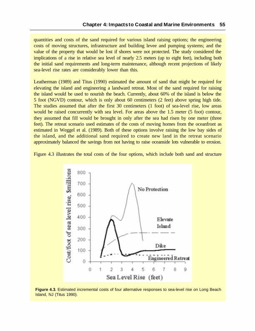
quantities and costs of the sand required for various island raising options; the engineeringcosts of moving structures, infrastructure and building levee and pumping systems; and thevalue of the property that would be lost if shores were not protected. The study considered theimplications of a rise in relative sea level of nearly 2.5 meters (up to eight feet), including boththe initial sand requirements and long-term maintenance, although recent projections of likelysea-level rise rates are considerably lower than this.
Leatherman (1989) and Titus (1990) estimated the amount of sand that might be required forelevating the island and engineering a landward retreat. Most of the sand required for raisingthe island would be used to nourish the beach. Currently, about 60% of the island is below the5 foot (NGVD) contour, which is only about 60 centimeters (2 feet) above spring high tide.The studies assumed that after the first 30 centimeters (1 foot) of sea-level rise, low areaswould be raised concurrently with sea level. For areas above the 1.5 meter (5 foot) contour,they assumed that fill would be brought in only after the sea had risen by one meter (threefeet). The retreat scenario used estimates of the costs of moving homes from the oceanfront asestimated in Weggel et al. (1989). Both of these options involve raising the low bay sides ofthe island, and the additional sand required to create new land in the retreat scenarioapproximately balanced the savings from not having to raise oceanside lots vulnerable to erosion.
Figure 4.3 illustrates the total costs of the four options, which include both sand and structure
Chapter 4: Impacts to Coastal and Marine Environments 55
Figure 4.3. Estimated incremental costs of four alternative responses to sea-level rise on Long BeachIsland, NJ (Titus 1990).

costs. Both retreat and island raising assumed that half the structures on the bay side would beelevated. The island raising scenario also assumed that half of the oceanside houses would beelevated. The retreat scenario estimated the amount of roads and utilities built on the newlycreated land as equal to the $20,000 per house moved. Both scenarios assumed no additionalcost for rebuilding infrastructure on elevated parts of the island, because water mains andsewers would presumably remain functional although roads and telephone poles would likelybe rebuilt anyway. For the protection scenario, in which the island is encircled with a levee, itwas estimated that a levee and drainage system could be constructed for $330 million.Although the cumulative costs of a levee system would be somewhat less than the cost ofraising the island (at least for a rise greater than one meter), the economics do not seemcompelling. From the perspective of financing, a levee would be more difficult to afford thanraising the island: A levee would require the community to secure an amount of capital equalto $26,000 per house; while island raising could be implemented gradually for a few hundreddollars per house per year. A levee would almost certainly reduce property values, due to theaesthetic problems of losing waterfront views and ready access to the bay.
The results of these studies suggest that for a rise of two feet or more, the cumulative cost ofprotection for any of the four options would be less than the value of the property lost withoutprotection. Moreover, comparing cumulative protection costs to lost property understates theeconomic viability of protection. Because a typical real estate investment has a payback periodof a decade, the viability of protection might be better approximated by comparing propertyvalues with the protection costs by decade. Over the course of a century, total rental valuewould generally be about ten times the market value of the property, that is, $20 billion. Thissuggests that should Long Beach Island be vulnerable to future sea-level change, some formof protection could be considered. These results also suggest that an engineered retreat wouldcost less, although the institutional problems of moving houses from the ocean front to the bayside would be great, as people’s position relative to the water would be altered
The issue of whether to protect or retreat from barrier islands at risk of severe erosion is anongoing and contentious issue in policy and management arenas (Heinz Center 2000; Pilkeyand Dixon 1996). It is clear that coastal development can adversely affect the integrity ofnatural features and processes in barrier island systems, and compromise the ability of naturalsystems to function following major storms or erosion events. Thus, there will be no easysolutions to the issues that will challenge those who live on and manage barrier islands as theyadapt to future sea-level rise. Management strategies will have to evolve with time as themagnitude and impacts of sea-level rise become more apparent.
4.2 WETLANDS
Understanding the combined effects of climate variability and change on ecosystems is frequentlyconstrained by a lack of existing information on the way in which ecosystem functions are affectedby environmental changes. For coastal wetland ecosystems the effects of global climate changecan be felt directly through changes in sea-level rise as well as indirectly through alterations in
56 The Potential Consequences of Climate Variability and Change

watershed inputs (Boesch et al. 1994; Brinson et al. 1995). Importantly, the response of uplandecosystems to climate change affects the timing and delivery of water and sediment to the coastalzone via interactions among precipitation, storms, landcover, and land use. This critical linkagebetween coastal and terrestrial ecosystems makes predicting the response of coastal wetlands toclimate change more complex and expands the range of factors to be considered. Because of thesedifficulties, the challenge of predicting the future of coastal wetlands becomes an increasinglysignificant problem as coastal areas continue to become heavily populated and developed, resultingin both direct and indirect deterioration and destruction of wetlands.
Coastal wetlands are valuable ecosystems. By providing refuge and forage opportunities for wildlife,fishes and invertebrates, marshes and mangroves around the coastal U.S. are the basis of theeconomic livelihoods of many communities. Shallow ponds and seed producing vegetation provideoverwintering habitat for millions of migratory waterfowl, and the structure of trees and forests isvital to songbirds and waders alike. The role of wetlands in absorbing nutrients and reducingloading to the coastal ocean is widely recognized, as is their value for protecting local communitiesfrom flooding; either by damping storm surges from the ocean or by providing storage for riverinefloodwaters. Thus, coastal wetlands are undoubtedly some of the most valuable ecosystems in thenation (see Section 2.2) and also some of the most threatened. Climate change and variabilitycompound existing stresses from human activities such as dredging and filling for development;navigation or mineral extraction; altered salinity and water quality resulting from activities in thewatershed; and the direct pressures of increasing numbers of people living and recreating in thecoastal zone.
We present here a discussion of how coastal wetlands (high and low salinity marshes as well asforested wetlands such as mangrove and baldcypress swamps) respond to climate variability andmight respond to climate change. Principal variables of concern to coastal wetlands include increasedatmospheric temperature and concentrations of carbon dioxide, alterations in river discharge,changes in sediment discharge, increased frequency and intensity of tropical cyclones andaccelerated sea-level rise. While direct scientific evidence for responses to individual factors issometimes available from experimental studies or localized opportunities, understanding of howthe various components of climate change interact at the land-sea margin has rarely been directlyexamined. However, the value of these ecosystems and the demonstrated potential for future changesin climate require us to assess the implications to coastal wetlands in order to develop and implementcoping strategies where possible.
4.2.1 Salt Marshes
Salt marshes occur in temperate areas in the lower reaches of estuaries and colonize the uppertidal flats where inundation frequency and duration are low enough to allow plant growth. Whilesaline marshes around much of the United States are dominated by the smooth cordgrass Spartinaalterniflora; regional variants include Salicornia virginica and Spartina foliosa in California andsouthern Oregon, and a more diverse assemblages including Distichlis spicata, Triglochin spp.,and Plantago maritima in the Pacific Northwest. In the west, these native halophytes are being
Chapter 4: Impacts to Coastal and Marine Environments 57

supplanted at low tidal elevations by invasive Spartina alterniflora which can grow vigorously onopen mudflats unavailable to the natives. Salinity typically varies between full strength to halfstrength (ca. 15psu) ocean salinity, depending on coastal physiography and the level of freshwaterinputs to the coastal ocean.
Many plants have adapted to hot and dry conditions through alterations in the way in which theyfix carbon in the Calvin cycle; commonly these plants are referred to as C4 plants (a minority ofplant species, but including important agricultural plants such as sugarcane and corn), whereasmost species are C3 plants. Studies of short-term response of photosynthetic rate to elevated CO2
indicate that the response will be greater in C3 plants than in C4 plants; indicating how the responseof salt marshes depends greatly upon the community composition. Curtis et al. (1989) showed anincrease in primary productivity of Scripus olneyi (C3) under increased CO2, but no indication ofan increase in the total nitrogen in above-ground biomass. Their findings also showed a dichotomybetween C3 and C4 plants in the effect of increased CO2 on the percentage of nitrogen found inleaf material, as well as to varying conditions of ultraviolet radiation (Van de Staaij et al. 1990).How such changes interact with environmental stresses from salinity and aerobic soil conditionsin salt marshes is a subject of ongoing research. Experimental studies of European salt marshspecies have shown that the growth reduction associated with increased salinity can be reduced tosome extent by CO2 enrichment (Rozema et al. 1990; Rozema et al. 1991) and other workers havenoted increased salt tolerance. Some agricultural species increased water use efficiency underelevated CO2, suggesting an increased tolerance for drought or salt tolerance. However, if nutrientuse efficiency of plants is also affected by enhanced CO2, these effects may be more difficult topredict.
Increases in salinity of coastal wetlands resulting from decreased freshwater discharge (andsubsequent intrusion by more saline offshore waters) may result in decreased productivity ofcoastal salt marshes, but should not necessarily result in a habitat shift. It is widely documentedthat Spartina alterniflora tolerates a wide range of salinities (Adams 1963; Webb 1983). Similarly,the variation in salinities found by Visser et al. (1998) in marshes dominated by the cordgrassSpartina patens was also wide (average salinity 10.4 ± 5.8 ppt), and overlapped with the zonedominated by Spartina alterniflora (average 17.5 ± 5.9 ppt) that it seems likely that major changesin salinity would be required to result in a significant change in habitat types in the more salinemarshes. Decreases in salinity will likely increase the productivity of salt marsh plants as osmoticstresses are decreased. However, the salinity data of Visser et al. (1998) suggest that decreases insalinity of more than 5 ppt might be required for Spartina alterniflora to be replaced by morebrackish marsh species.
Salt marshes experience little wind damage from tropical storms and hurricanes but are stronglyinfluenced by storm tides. The severity of storm surge impacts is highly correlated with the speedand path at which the storm approaches the shore. Hurricane Hugo caused little geomorphic changeto the salt marsh at North Inlet, SC because it crossed the shore rapidly with little rainfall (Gardneret al. 1991). By contrast, Hurricane Andrew caused widespread damage to coastal marshes inLouisiana because it crossed the shore slowly and at an oblique angle (Guntenspergen et al. 1995).
58 The Potential Consequences of Climate Variability and Change

Storm surges can introduce sediment into the marsh and redistribute sediment as portions of themarsh are eroded (Cahoon et al. 1995; Guntenspergen et al. 1995; Nyman et al. 1995) resulting insubstantial sediment accretion and geomorphic changes. Tropical storms are potentially importantboth in providing a pulse of sediment over a broad geomorphic scale to balance the effects ofsubsidence, particularly for deltas, and in enhancing coastal marsh survival for areas remote froma sediment source. Despite delivering sediments to the marsh surface, tropical storms and hurricanesare capable of compacting some highly organic and weakened marsh substrates, resulting in a lossof elevation, apparently by the weight and force of the storm tide surges (Cahoon et al. 1995;Cahoon et al. 1998).
Perhaps the most widely examined effect of climate change on coastal salt marshes are theirresponses to sea-level rise. Salt marsh surfaces are frequently considered to be in an equilibriumrelationship with local mean sea level (e.g., Pethick 1981; Allen 1990), and indeed dating ofburied salt marsh peats is a frequently used technique for reconstructing past sea-level changes(e.g., Orson et al. 1998). That marsh surface elevation changes to keep pace with sea-level rise iswell established; unfortunately researchers are unsure whether the elevation change is driven bysea-level change or whether the space provided by a rising sea level merely allows the increase inelevation to occur. The latter would imply that elevation change is limited by sea-level conditions(see Gehrels and Leatherman 1989; and Reed 1990 for reviews). The projection of salt marshsustainability under future climate scenarios a complex issue and depends on: the relative importanceof organic matter to marsh vertical development (Bricker-Urso et al. 1989); the complexitiesgoverning organic matter accumulation during rising sea level (Reed 1995); the importance ofsubsurface processes in determining surface elevation change (Cahoon et al. 1995); and the roleof storm events and hydrologic changes in controlling sediment deposition, soil conditions andplant growth (Cahoon et al. 1995b; Goodbred et al. 1998; Kuhn et al. 1999).
A group of researchers (Working Group on Sea-level Rise and Wetland Systems 1997) identi-fied the rate of sea-level rise as one of the key issues to the ability of marsh systems to copewith climate change. Some answers may be found where subsidence already produces rapidrates of relative sea-level rise (RSLR) for coastal marsh areas. In the Mississippi Deltaic Plainsome studies have suggested that marshes cannot keep pace with relative sea-level rise ratesapproaching 1 centimeter per year (Baumann et al. 1984). Many parts of this system are beingrapidly degraded, for a wide range of reasons which are detailed more fully in the followingcase study (see also Boesch et al. 1994). On the other hand, tide gauge records show these ratesof sea-level change have been occurring for decades in some parts of coastal Louisiana, yet vastareas of salt marsh still exist (e.g., Fuller et al. 1995). These marshes are diminishing in area bymarginal erosion rather than submergence effects.
This suggests that under optimum conditions of sediment supply, salinity, and water quality,salt marshes may be able to survive rates of sea-level rise as high as 50 centimeters (18 to 20inches) in 50 years; rates lower than the expected rise in sea level estimated for much of thecoastal U.S. over the next 100 years. Local subsidence or hydrologic changes, however, couldincrease the rise in sea level experienced by individual marshes perhaps exceeding the local
Chapter 4: Impacts to Coastal and Marine Environments 59

threshold of marsh vertical development. Figure 4.4 illustrates this process graphically. ForLouisiana, Swenson and Swarzenski (1995) noted that for periods of several years at a time inthe late 1960’s and early 1970’s tide gauges have recorded rates of relative sea-level rise ashigh as 6 cm per year. Such high rates are considerably greater than global long-term trends insea level. The cause of these perturbations is unclear and may be associated with peculiarcombinations of river discharge and wind patterns. Yet this period does coincide with a periodof very high land loss in coastal Louisiana confirming the notion of an upper limit of the rate ofsea-level rise beyond which marsh deterioration occurs. Even if thresholds are exceeded onlylong enough for marsh vegetation to be stressed and die, the consequences for coastal saltmarshes are serious.
4.2.2 Low salinity marshes
Inland from salt marshes but still close enough to the coast to experience tidal fluctuations in
Figure 4.4. How coastal wetlands respond to sea-level rise depends greatly on the supply of sedimentswith which soils can be accreted sufficiently to allow the surface of the wetland to gain elevation. With highsediment supplies coastal marshes and mangroves can persist even under high rates of relative sea-levelrise. (Reed 1999).
60 The Potential Consequences of Climate Variability and Change

water level, are wetlands dominated by a variety of grasses and annual and perennialbroadleaved aquatic plants. This wetland type is found most commonly in the mid and southAtlantic coasts and in Texas and Louisiana, as well as in upper reaches of estuaries on the WestCoast. Species diversity is high and dominant plants may include bulrush, maidencane and wildrice species (such as Scirpus californicus, Panicum hemitomon or Zizania aquatica). Here theeffects of climate change and variability on low salinity marshes will manifest themselves aschanges in salinity and flooding regime associated with changes in freshwater delivery to thecoastal zone, or with sea-level rise and the physical stresses of storm surges.
Increased salinity penetration, either sustained or pulsed, can dramatically affect low salinitycoastal wetlands. Wetland species have developed various adaptations to higher salt concentra-tion, such as mechanisms to extrude salt from their tissues, mechanisms to balance the osmoticpotential of the salt with other compounds, and means to secrete salt from their tissues throughspecially produced salt glands (Mitsch and Gosselink 1993). However the tolerance for saltvaries widely among wetland plants, and even plants which usually can tolerate some salinitycan be negatively affected by changes in salinity. For example, growth of the cordgrassSpartina patens, usually considered a salt tolerant species and found in low marshes in Louisi-ana at an average salinity of 8.5 psu (Chabreck 1972) was shown to be adversely affected bysalt concentrations above about 5 psu in higher march substrates (Pezeshki and DeLaune 1993).Another species (maidencane, P. hemitomon) typical of freshwater marshes was able to grow,albeit at a reduced rate, at a salinity of 9 psu for a month in one study (McKee and Mendelssohn1989), and showed 76% carbon assimilation at 5 psu in another (short-term) study (Pezeshki etal. 1987b). Clearly the magnitude and frequency of salinity pulses introduced into freshermarshes as a result of climate change will determine whether fresher marshes species survive.Gradual changes in salinity, associated with long-term trends of decreased freshwater dischargeto coastal areas, will likely result in a transition to more salt tolerant species; however, concur-rent changes in salinity patterns that result in decreased plant productivity may impair theability of marshes to keep pace with sea-level rise.
Increasing marsh surface elevation is fundamental to prevent coastal submergence and thus lossof vegetated wetlands under conditions of sea-level rise (Reed 1995). While the accumulationof inorganic sediments is viewed as critical to the vertical development of substrates of man-grove and salt marsh systems, organic accumulation is more important in typically more peat-based substrates of low salinity marshes. The dependence of low salinity marshes upon thegeneration of organic material means that their ability to respond to changes in mean sea level iscritically related to the ecological thresholds associated with flooding, plant productivity anddecomposition of organic material. Blum (1993) has found in Virginia marshes that differencesin organic matter accumulation between high and low marshes are due to differences in rootproduction rather than root decomposition. Root production in these marshes appears to beinfluenced by variations in tidal inundation conditions, suggesting a sensitivity of this contribu-tion to vertical accretion to alterations in flooding regime caused by sea-level rise. If marshflooding exceeds the ability of marsh plants to build organic soil, or result in soil waterloggingand plant deterioration, then organic coastal marshes will not survive.
Chapter 4: Impacts to Coastal and Marine Environments 61

In the rapidly subsiding Mississippi Deltaic Plain there are many fresh marsh areas which aresubjected to high rates of relative sea-level rise (1 cm per year in many areas). In part, theserates may be due to the development of “flotant” or floating marshes. These are described bySasser (1994) as “wetlands of emergent vegetation with a mat of live roots and associated deadand decomposing organic material and mineral sediments, that moves vertically as ambientwater levels rise and fall.” That the mat can move in response to water level variations indicatesthat plants are unlikely to be stressed by increases in mean sea level alone. Sasser (1994) sug-gests that the floating marshes of the Mississippi Deltaic Plain probably developed under fresh-water conditions removed from riverine sediment inputs. Under certain conditions, floatingmarshes form when natural “attached” organic marshes are subjected to subsidence or sea-levelrise and the buoyant organic mat is subjected to increasing upward tension (O’Neil 1949). Themarsh eventually breaks free from its mineral substrate and floats. This adaptation to sea-levelrise relies upon buoyancy of the organic mat – a characteristic of marshes with minimal mineralsediment deposition. However, where sulfate is present in marsh soils, some mineral sedimentinput is required to buffer the development of toxic sulfides. Thus, the development of floatingmarshes is probably constrained to areas of very low salinity, where sulfide is less of a problem,and low mineral sediment inputs. In these areas, marshes that maintain surface elevation underconditions of sea-level rise may undergo a change in marsh character, from attached to floating.
Even if low salinity marshes with highly organic substrates can survive sea-level rise their long-term sustainability may be reduced because of increased sensitivity to greater storm surgeimpacts. Among the impacts of 1992’s Hurricane Andrew on low salinity marshes were theintroduction of large quantities of sediment onto the marsh surface that smothered vegetation,the introduction of salt water into fresh marsh resulting in salt burn, the disruption and erosionof organic marsh substrates, and the distribution of large quantities of wrack onto marsh thatkilled the underlying vegetation (Guntenspergen et al. 1995). However, plant cover was quicklyre-established in all impact types except for scour areas and areas of thick wrack accumulation.Additionally, shifts in species dominance resulted in laterally compressed areas because ofincreases in elevation (as much as 1 to 2 meters). Elevation decreased continuously to aboutpre-storm elevations in these areas over the next two years (Cahoon et al. 1995). Any increasein the frequency or magnitude of such storm impacts associated with climate change will reducethe time for recovery from such impacts and threaten the long-term sustainability of theseorganic substrates.
4.2.3 Mangroves
Mangroves, comprising approximately 60 species of trees and shrubs, are the predominant formof vegetation in the intertidal zone of tropical estuaries, lagoons, and sheltered coastlines. Theyare largely confined to latitudes between 30 degrees north and south of the equator, with a fewnotable exceptions that may be explained by the occurrence of warm ocean currents or by thepresence of relict populations of more poleward past distributions (Duke 1992). According toone recent estimate, the total area of mangroves in the world is 181,000 square kilometers(Spalding et al. 1997); although only a small fraction of this habitat is found within the states
62 The Potential Consequences of Climate Variability and Change

and territories of the United States. In the continental U.S., well-developed mangrove forestsare found only in South Florida, although mangrove communities also exist in the Caribbean,Hawaii and throughout territories in the South Pacific. The impacts of climate change andvariability on these systems occur via changes in atmospheric conditions such as CO2 concen-trations and temperature, ability to cope with sea-level rise, and structural damage to the forestcanopy during storm events.
Increases in air, soil and water temperature may affect the growth and distribution of manycoastal forested wetlands. Most mangrove species in tropical regions appear to have maximalshoot growth at around 25°C and maximum rates of photosynthesis at around 28 to 32°C(Clough et al. 1982; Andrews et al. 1992). Therefore, changes in productivity may be relativelyminor. Because temperature increases may stimulate productivity of mangroves to a muchgreater degree at subtropical and temperate latitudes, global increases in air temperature mayresult in poleward shifts in the distribution of tropical and subtropical species such as man-groves. The limiting factor for at least some species, however, is not mean temperature, but theoccurrence of low temperature or freezing events that exceed tolerance limits (McMillan andSherrod 1986; Snedaker 1995). Better data on the likely changes in such events are neededbefore poleward shifts can be projected with any degree of certainty, although warmer winteratmospheric temperatures projected by climate models for the southeastern U.S. make north-ward expansion of the range of mangroves on the Gulf and Atlantic coasts likely. Duke (1992)suggests that a particularly important factor controlling the poleward distribution of mangrovesis winter water temperature. He found that mangrove distribution generally matches the 20°Cwinter isotherm.
Mangrove forests are susceptible to catastrophic wind damage from tropical cyclones; oftenresulting in mortality and significant changes in forest structure and function (Wanless et al.1994; Doyle et al. 1995; Baldwin et al. 1995). Recovery following storms can be rapid (Brokawand Walker 1991; Frangi and Lugo 1991; Roth 1992), but more frequent or intense storms arelikely to result in long-term structural and functional changes in forested wetlands. Mangrovesin the Caribbean region, for example, may be shorter in stature in the future (Doyle 1999) ifstorms are more frequent. Snedaker (1995) suggests that more frequent storms in the Caribbeanmay favor the black mangrove Avicennia germinans and the white mangrove Lagunculariaracemosa over the red mangrove Rhizophora mangle, because of the former species’ greatercapacity to recover following severe structural damage (but see also Doyle 1999). In addition,the death of red mangrove trees has been related to the conversion of forest to mudflat habitat(Wanless et al. 1994) apparently caused by a rapid loss of elevation related to oxidation ofmangrove peat (Snedaker 1995; Wanless et al. 1995).
There have been few experimental studies of the effects of enhanced CO2 concentrations on thegrowth of mangrove species, and these have focused on the response of mangrove seedlingsonly under controlled greenhouse conditions. Red mangrove seedlings grown under elevatedCO2 conditions had higher “root to shoot” ratios, relative growth rates, and net assimilationrates, and greater biomass, leaf area, and stem length (Farnsworth et al. 1996; Ball et al. 1997).
Chapter 4: Impacts to Coastal and Marine Environments 63

Seedlings exposed to elevated CO2 for one year reached sexual maturity two years earlier thantypically occurs under field condition (Farnsworth et al. 1996). The growth of the red man-groves R. apiculata and R. stylos were enhanced by elevated CO2 levels, but the response ofeach species differs along salinity and humidity gradients (Ball et al. 1997). This suggests thatcurrent differences in forest structure and productivity along salinity gradients may becomegreater under a regime of increasing atmospheric CO2 . Both of these studies indicate that man-groves can be flexible in their response to elevated CO2 and that these findings must be inte-grated into the impacts of sea-level rise to yield accurate predictions of the effects of localclimate change to mangrove ecosystems.
The much greater volume of research on the effects of elevated atmospheric CO2 on agriculturaland upland forest systems and in herbaceous wetlands suggests that some growth enhancementis likely, at least for seedlings, but the long-term impacts on productivity, nutrient cycling, andother ecosystem processes are very uncertain. There appears to be a high potential for signifi-cant interactions between atmospheric CO2 concentrations and plant responses to salinity,temperature, nutrient, and water stress, and Field (1995) recommends long-term assessments ofCO2 effects under conditions where these factors are controlled.
Freshwater inputs can moderate salinity distributions in the coastal zone. Although mangroveforests are ecologically confined to high salinity coastal areas, mangrove productivity increasesproportionally with the availability of fresh water (Pool et al. 1977). This response is modulatedby reductions in pore water salinity and thus salt stress. The production and accumulation ofmangrove peat has been observed to be great in low salinity mangrove impoundments inFlorida. If freshwater runoff decreased to the point where mangroves were continually exposedto higher salinities then organic production would be expected to decline (Snedaker 1995). Gasexchange studies (Ball and Farquhar 1984) indicate that net photosynthesis in mangrovesdecreases as salinity increases. The higher sulfate concentrations of high salinity waters wouldalso facilitate anaerobic decomposition by sulfate reducers and the potential loss of existingmangrove peat. This response may have implications for the survival of mangrove forests underincreased sea-level rise, but increased salinity alone is unlikely to result in catastrophic loss ofmangrove forests.
The response of mangroves to sea-level rise will vary depending on the forest type, environ-mental setting, and supply of freshwater and sediment. Mangroves have historically kept pacewith sea-level rise through extensive peat production, which depends on an adequate supply offresh water to maintain root growth, and sediments (Snedaker 1993). Mangroves not onlymigrate upslope in response to sea-level rise given an adequate sediment supply and room forlandward expansion; but they may also expand seaward if sedimentation is rapid (Woodroffe1992). From a global literature review of 14C dating of mangrove peats, Ellison and Stoddart(1991) concluded there will be a world wide collapse of mangroves when the global rate of SLRexceeds 1.2 mm per year. This was based largely on their perception that mangroves exhibithigh fidelity to particular habitats. They predict that low carbonate islands, such as those foundin south Florida and many areas in the Caribbean, are particularly vulnerable to submergencebecause of limited input of sediments from terrigenous sources.
64 The Potential Consequences of Climate Variability and Change

In contrast, Bacon (1994) predicted that there will be a variety of responses for mangroves inthe Caribbean, including loss, migration, change in forest structure (see also Snedaker 1995),and expansion, because of the wide range of wetland types and geomorphic settings in whicheach mangrove species occurs. Similarly, Snedaker et al. (1994) indicates that mangroves insouth Florida expanded during a 60 year period when the rate of sea-level rise was 2.3 mm peryear. Our understanding of how mangroves will respond to sea-level rise is limited, in part, by alack of knowledge of short-term accretionary processes in mangrove forests (Woodroffe 1992).Cahoon and Lynch (1997) noted that in a red mangrove forest in southwestern Florida, filamen-tous turf algae and the dense mangrove root mat bound unconsolidated sediments in place.Hence, both sediment deposition processes and root growth at the soil surface contributed tovertical soil development. They also found that the ability of that mangrove forest to keep pacewith sea-level rise was best described by short-term measures of vertical accretion and elevationchange than by longer-term measures of vertical accretion by using lead 2 1 0Pb dating techniques.
Case Study: Wetland Loss in Coastal Louisiana
Between 1956 and 1990, Louisiana coastal wetlands were lost at rate of 60 to 100 squarekilometers (24 to 40 square miles) per year. As approximately 40% of the nation’s brackishand freshwater coastal wetlands are found in Louisiana, this constituted as much as 80% of thetotal loss of these wetlands in the U.S. (Boesch et al. 1994). Unlike wetland loss in other partsof the country, wetlands lost in South Louisiana were generally converted to open water ratherthan drained and filled for agriculture or other types of development. The remaining 1.4 millionhectares (3.5 million acres) of wetlands in South Louisiana provide critical nursery areas forfinfishes and crustaceans (particularly shrimp and crabs) that make up the bulk of Louisiana’sseafood industry. Additionally, these coastal wetlands serve as important buffers for stormsurges, protecting inland residential and commercial infrastructure from severe flooding.
Wetland zonation in the highly structured ecosystem is structured by factors such as tidalinfluence, soils, elevation, freshwater inflows and energy regimes. Plant communities gradeinland from salt marshes near the Gulf shoreline to brackish marshes, freshwater marshes andwooded swamps. These coastal wetlands serve as important buffers for storm tides, thusprotecting inland residential and commercial infrastructure from severe flooding. The continuedloss of Louisiana’s coastal wetlands threatens more than $100 billion in public, private andcommercial construction, including the infrastructure that handles over 60% of U.S. oil importsand about 90% of the oil and gas produced in U.S. Outer Continental Shelf. However, the oiland gas industry itself has been directly responsible for a substantial proportion of these losses,as wetlands have declined in response to the combined effects of canal dredging and thefragmentation of wetlands into smaller units which are more vulnerable to the forces of tides,storms and boat wakes.
A combination of anthropogenic and natural factors contribute to the dramatic wetland lossesin South Louisiana, where seasonal overbank flooding of the Mississippi River successivelycreated six distinct deltaic land masses over the last 7,000 years. Subsidence has largely
Chapter 4: Impacts to Coastal and Marine Environments 65

attributed to dewatering and compaction of sediments deposited by deltaic processes. Globalsea-level rise combines with subsidence to produce rates of relative sea-level rise in Louisianain excess of 1 cm/yr as measured using tide gauges. In the past, each time the river shifted itscourse away from an active delta, the abandoned delta began to naturally deteriorate, formingbarrier islands and erosional headlands. When people levied the Mississippi River to preventflooding, the natural processes that build and maintain coastal wetlands were disrupted. Damconstruction in the upper parts of the Mississippi River basin since 1950 reduced the amountof sediment transported by the river by about 50%, limiting potential accretion in this sediment-dependent ecosystem.
Other human activities that exacerbate these problems include the dredging of access canals,well sites, and pipeline rights-of-way for oil and gas extraction. By 1994, 523 oil fields hadbeen discovered in Louisiana’s coastal zone and 23,477 wells had been drilled. Dredging ofnavigation channels for other forms of commerce increased tidal exchange in many embayments.Drainage of formerly wetland soils in New Orleans and other population centers acceleratednatural sediment compaction, lowering their elevation and increasing their susceptibility toflooding. These changes to natural hydrology alter the balances between sediment deposition,plant growth, organic matter, accumulation and subsidence that have maintained the coastalmarshes for thousands of years. The result is that marshes fail to maintain their elevation,gradually becoming waterlogged with plants and soils submerged for longer periods on eachtide. Eventually, the plants die and soil integrity is lost allowing rapid erosion of the remainingmarsh substrate. Additional stress is placed on fresher marshes and forested wetlands bypenetration of saltier water further inland via canals and rapidly expanding coastal bays. Becauseof the altered hydrology these changes in salinity frequently occur too rapidly for the naturaltransition to more salt tolerant vegetation to take place and marshes and swamps are converteddirectly to open water. Once lost, coastal wetlands have proven to be extremely difficult torestore.
Vegetated wetlands characteristically capture sediment from surface waters and produce organicmatter that results in vertical accretion of the wetland surface. In some areas of South Louisiana,wetlands accrete material sufficiently to keep pace with current rates of relative sea-level rise.In other areas, subsidence dominates and plant growth is reduced. Thus, if global warmingincreases the rate of sea-level rise beyond the present average for the Gulf of Mexico, thoseregions of coastal Louisiana where marshes are currently on the margins of survival will suffer.Critical ecological thresholds will be crossed when flooding and salinity are too great for plantsurvival and even more extensive land loss will result.
Accelerated sea-level rise that may result from global warming is being considered in effortsto address coastal wetland loss in Louisiana. However, because regional subsidence dominatesrelative sea-level rise and is expected to do so for many decades, most management attentionis being directed to protecting and restoring barrier islands that shield the wetlands from waveattack, managing wetland hydrology, and diverting the flow of river water and sediments intothe coastal wetlands. An ambitious plan has been developed by state and federal authorities
66 The Potential Consequences of Climate Variability and Change

under the Coastal Wetlands Planning, Protection and Restoration Act to achieve somesustainable condition by 2050 (Louisiana Coastal Wetlands Conservation and Restoration TaskForce and Wetlands Conservation and Restoration Authority 1998), however its implementationfaces daunting scientific, technical, social and economic challenges. The potential consequencesof climate change on these coastal wetlands add but another formidable challenge.
4.2.4 Freshwater Forested Wetlands
Coastal freshwater wetland forests frequently have an extremely diverse flora of trees, shrub andherbs (Conner et al. 1986). In the southeastern United States they can be roughly divided intodeepwater swamps dominated by baldcypress (Taxodium distichum) and tupelo gum (Nyssaaquatic), with a red maple (Acer rubrum) and buttonbush (Cephalanthus occidentalis) understory;and a seasonally flooded bottomland hardwood forests dominated by several oak species (Quercusspp.), green ash (Fraxinus pennsylvanica var. lanceolata), and other hardwood species. The impactsof climate change and variability on these systems are likely to occur via changes in salinity,ability to cope with sea-level rise, and structural damage to the forest canopy during storm events.
Changes in salinity regime can result from either decreased freshwater discharge to the coastalzone, or from increasing sea level which allows penetration of salt water into previously freshwaterareas. The result of changes in salinity regime for the forest community depends on the magnitude,rate and periodicity of salinity increases. Many studies have examined the effects of salinity onbaldcypress, and it is apparent that intraspecific variations in plant response need to be understoodbefore the effects of salinity change at the landscape scale can be assessed. Allen et al. (1997)showed that baldcypress seedlings from a variety of coastal and inland swamp locations couldtolerate salinities of 2 psu. Higher salinities resulted in reduced leaf biomass with lesser effects onroot biomass and stem biomass. However, Myers et al. (1995) did not find groundwater salinitylevels of 2.8 psu as limiting cypress seedling growth; and Conner and Askew (1992) note thatolder seedlings are more able to tolerate pulses of salt water (30 psu) as might be experiencedduring storm surge flooding of an interior swamp forest. The storm surge caused by HurricaneHugo flooded some low-lying coastal forests greater than 3 m deep with salt water, and the stormsurge carried saline water (> 20psu) along waterways up to several hundred kilometers inland(Blood et al. 1991). Elevated soil salinity levels lingered for months and had adverse affects ontree survival and growth, as well as on nutrient cycling processes (Blood et al. 1991; Williams1993).
The effect of tropical cyclone activity on forested wetlands can be structural as well as hydrologic.Low salinity and freshwater forested wetlands differ in their susceptibility to tropical storm impacts,with damage to forest types generally greatest to pines, least to swamp, with hardwoods intermediate(Conner 1998). This pattern was generally followed with the effects of Hurricane Andrew in southFlorida, where cypress trees located in cypress domes experienced little damage while 85% of thepine trees sampled on hardwood hammocks suffered major stem damage (Slater et al. 1995).Damage to the forests on the hardwood hammocks also led to invasion by exotic species followingHurricane Andrew (Horvitz et al. 1995). In the Atchafalaya River basin in south Louisiana,
Chapter 4: Impacts to Coastal and Marine Environments 67

Hurricane Andrew caused little damage to cypress-tupelo communities but caused significantdamage and mortality to bottomland hardwood forests where forest structure and function werealtered (Doyle et al. 1995). However, in some areas in the vicinity of Cape Cod, Atlantic whitecedar wetlands were more severely affected by blowdowns from Hurricane Bob than adjacentupland forests, a fact attributed to their relatively shallow root systems (Valiela et al. 1998).
Combined effects of climate change and variability on freshwater discharge to the coastal zoneand sea-level rise rates will likely result in increased flooding in many coastal swamp systems.Increases in freshwater discharge during floods are unlikely to result in any deleterious effects infreshwater forested wetlands as long as seasonal low-water periods allow for substrate drainageand forest regeneration. Baldcypress regenerates well in swamps where the substrate is moist andwhere competing species are unable to cope with flooding. Seedlings must experience dry periodslong enough to allow growth and survival during future flooding (Conner and Toliver 1990).DeLaune et al. (1987) recognized gradients in seedling survival for both baldcypress and oakspecies along an elevation gradient in a Louisiana coastal swamp. Increased flooding thus reducesthe area of appropriate elevation for seedling survival. Furthermore, Rheinhardt and Hershner(1992) reported that increased saturation of substrate also alters species composition in freshwaterswamps. They found ash and black gum (Fraxinus spp. and Nyssa sylvatica) in wetter areascompared to red maple and sweetgum (Acer rubrum and Liquidambar styraciflua) within drierswamps of the Virginia coastal plain. Similarly, Conner and Brody (1989) noted a change frombottomland hardwood species to water tupelo and baldcypress in model simulations of the effectof relative sea-level rise on Louisiana forested wetlands.
Regarding the ability of freshwater forested wetlands to survive sea level, Rheinhardt and Hershner(1992) note that freshwater swamps are “precariously positioned” at the upper reaches of tidalpenetration and keep pace with sea-level rise by accumulating biomass. An experimental study byDay et al. (1989) showed slow root decomposition in both periodic and frequently flooded studysites containing baldcypress seedlings. This suggests that accumulation of dead organic matterwill not be impaired by rising water levels associated with sea-level rise. Connor and Day (1991)found a positive relationship between vertical accretion of swamp soils and flooding duration butalso note that accretion was dependent upon the availability of suspended sediments in the floodingwaters. Thus the effects of increased flooding from riverine systems associated with climate changemight also provide increased sediments that allow swamp systems to keep pace with sea-levelrise.
4.2.5 Summary of Climate Impacts
The survival of coastal wetlands under conditions of altered climate really depends primarily onthe ability of the plants to adapt and keep up with the rate of change. The biogeomorphic processeswhich control the wetland landscape may produce gradual changes, e.g, from marsh to mangroveswamp, as long as the environmental thresholds which control plant survival are not crossed. The
68 The Potential Consequences of Climate Variability and Change

challenge in predicting coastal wetland response, either the nature of the gradual change, or whenand where the thresholds are exceeded, depends upon interactions among the responses to thevarious climate forcing discussed here. Even when considered individually the various systemresponses are complex:
Atmospheric Changes: Increased CO2 and temperatures generally mean increased plant production.The response varies between species however, and will likely change competitive interactionswithin vegetative communities. The potential decreased growth associated with UV-B, or changesin nutrient allocation and utilization might counter any increases associated with other atmosphericchanges.
Freshwater Inputs to Coastal Wetlands: More fresh water is generally beneficial to coastal wetlands,and a decrease may result in salinity stress for some communities. Furthermore, a gradual changedoes not necessarily result in wetland loss and salt and brackish marshes may replace freshwatermarshes and swamps. However, the expected spatial variations in runoff associated with variousclimate scenarios make generalizations about response impossible; examples of where thresholdsfor coastal plants may be exceeded are in the western Gulf of Mexico where already limitedfreshwater inputs are expected to decrease dramatically in the future.
Sediment Delivery to Coastal Areas: For coastal wetlands that already face gradual sea-level rise,increased sediment delivery increases sustainability by providing for vertical accumulation ofsubstrate. Dramatic sediment delivery events could increase elevation sufficiently to convertwetlands to areas of upland vegetation, but unless the net effect is greater than the cumulativeeffects of sea-level rise, episodic sedimentation should be seen as part of dynamic equilibrium,balancing long-term sea-level rise.
Storms: The resilience of coastal wetlands to storm effects varies with salinity. Fresher systemsare more susceptible to saline incursions during storms while the structure of some mangrovespecies reduces their vulnerability to wind damage. The long-term effect of storms on coastalwetlands depends upon the recovery time and the return interval of the storms. Climate inducedchanges in frequency, if not intensity, of storm impact may therefore result in irreversible damageto forested systems or fragile organic substrates. For minerogenic salt marsh soils, however, stormscan provide inputs of sediment essential to vertical sustainability.
Sea-Level Rise: The effects of sea-level rise, at least at the rates currently projected by GCMscenarios, are unlikely to have a catastrophic impact of coastal wetlands in themselves before themiddle of the next century; but when combined with subsidence and other environmental changes,the consequences may be severe. Human alterations to coastal landscapes in the last several centurieshave been dramatic. The human development of interior wetland margins can prevent or hinderthe natural landward migration of wetlands that are susceptible to sea-level rise. Furthermore,groundwater withdrawals may exacerbate the effects of sea-level rise and produce subsidencestress independent of climate change. In terrestrial and fluvial systems, dams and levees placed toenhance navigation or water supply and prevent flooding lead to the reduction of sediment and
Chapter 4: Impacts to Coastal and Marine Environments 69

freshwater supply to coastal areas, limiting the natural ability of wetlands to cope with rising sealevel.
It is important to recognize that these various responses may interact in ways that are difficult topredict, and that these factors and their interactions may result in a host of indirect effects oncoastal wetlands, such as changes in patterns of herbivory or the effects of invasive species. Mostmangrove and freshwater forested wetland plant species are many millions of years old (Duke1995). Thus they have survived through numerous and very large-scale changes in climate andsea level; including glacial-interglacial periods associated with changes in sea level of 100 ormore meters (Woodroffe 1990). Survival under such circumstances generally depended on theability to migrate, rather than on the persistence of individual wetlands. Individual wetlands todaycan either accumulate vertically to maintain their position in the coastal zone or migrate as in thepast. Studies show that both can occur, where conditions are favorable.
However, in today’s human-dominated environment shoreline developments and other types ofbarriers will limit options for migration. Vertical, rather than lateral, adjustment is therefore thekey to wetland survival. Control of river discharge and capture of sediments by dams alter the fluxand deposition of sediments that, in the geologic, or even historic, past may have ensured wetlandsustainability through vertical accumulation of substrate.
Case Study: South Florida Regional Ecosystems
The South Florida regional ecosystem includes upland, wetland, freshwater, estuarine, andcoastal ecosystems all closely linked by surface and groundwater hydrology. A large and veryrapidly growing human population is perched on a very narrow strip of land along the coast.This population is highly dependent on the health of the environment for its economic base;especially tourism, recreational fishing and agriculture. The proximity of the EvergladesNational Park, Biscayne National Park, and the Florida Keys National Marine Sanctuaryillustrates the high value society places on this unique environment. The coral reef and fishcommunities in particular are extensive and provide major sources of recreational fishing anddiving.
The historical (pre-drainage) South Florida landscape was a hydrologically interconnectedmosaic of habitats, including freshwater marshes, hardwood tree hammocks, cypress swamps,pinelands, mangrove swamps, freshwater lakes and streams, estuarine lagoons and coral reefs(Harshberger 1914; Davis 1943; Craighead 1971; Duever et al. 1986; Gunderson 1994; Daviset al. 1994; DeAngelis 1994). Fresh water flows as a shallow sheet across the gently slopinglandscape below Lake Okeechobee, through the tangled mangrove forests to the estuaries andout to the coral reef tract. Fresh water flow is the unifying force and sustaining element of thesystem. Wading birds, alligators, sawgrass plains, mangroves, and tropical hardwood hammocksare among its most recognizable features. However, the essence of the Everglades is theabundance and diversity of species that once lived among the diverse range of habitats spanningvast open spaces.
70 The Potential Consequences of Climate Variability and Change

This landscape derived from a unique combination of climate, soil, substrate, and topography(Obeysekera et al. in press) and a unique mixture of tropical, temperate, and endemic plantspecies. Episodic events, such as fires, freezes, floods, droughts and hurricanes, controlled thestructure of the landscape. Fires were associated with the dry season and dry years, and evenvery small elevational differences led to totally different responses to the natural fires. Forexample, the shallow (1 meter deep) moat surrounding hardwood hammocks, that themselveswere only a meter or so higher than the surrounding sawgrass plains, protected the hammocksfrom fire. This allowed hardwood trees to reach ages measured in decades and even centurieswithin an expansive matrix of sawgrass that burned on cycles of a few years (Robertson 1962;Gunderson and Snyder 1994).
Currently nearly 5 million people live in urban centers within a few kilometers of this formerecological paradise, and the population of Florida as a whole continues to grow at a rate ofalmost one million people per decade. Water, once the critical characteristic of the naturalsystem, has become the most limiting resource. The lack of adequate quantities and timelydistribution of clean water to coincide with the system’s natural cycles has reduced theEverglades to a degraded remnant of its former self, which continues to decline. The naturalvariability of surface water has been altered dramatically, so that now in very wet years, massiveamounts of freshwater are discharged directly “to tide” (meaning discharged through canalsand pumps into a few coastal estuaries). However, the historical sheetflows of water that usedto flow into other parts of the coast, especially Florida Bay, have now been substantially reduced,occasionally resulting in hypersaline conditions. The human-dominated nature of thehydrological and, therefore, ecological systems of the region will fundamentally affect theirability, or lack of ability, to adapt to climate change over the next century. These ecosystemswill be influenced by potential changes in air and sea surface temperatures, the frequency ofepisodic freeze events, altered precipitation patterns, the frequency of droughts and associatedfires, impacts of hurricanes and tropical storms, and changes in the rate of sea-level rise.
Temperature Changes
The Canadian and Hadley models, as well as most other GCMs, strongly suggest that therewill be increases in global mean annual atmospheric temperatures, with greater increasesexpected in higher latitudes and for nighttime values. Outputs for regions on the scale of SouthFlorida are less certain, particularly because of its dominant maritime influence (Miami is oneof the very few cities in all of the United States that has never experienced a 100o F temperaturereading). However, elevated mean annual temperatures for South Florida may not be asconsequential as elsewhere; both because these increases may be smaller and because theecosystems of the region are already largely adapted to warm tropical conditions. Analyses byHarris and Cropper (1992) using the Holdridge life-zone model indicate little migration ofhabitats in South Florida, although the northern limits of the tropical and subtropical habitatswould migrate up the Florida peninsula. However, South Florida is already ripe with exoticspecies that have invaded from more tropical areas, and there is a serious concern that climate
Chapter 4: Impacts to Coastal and Marine Environments 71

change might favor these highly opportunistic species to the disadvantage of native species,(Malcolm and Markham 1997).
Changes in the frequency of episodic freeze events is another possibility. One might expectthat climate change would reduce the frequency of such events, although there is little confidencethat such a prediction can be asserted based on GCM results. For example, during the 1980’s,which to that point was the warmest decade in U.S. history, there was a series of severe freezesin Florida. Many areas that for decades had been prime citrus production regions had theircrops completely wiped out, and citrus production moved significantly farther south. Thedistribution of citrus is an excellent surrogate for the latitudinal distribution of frost sensitivecoastal species, especially mangroves. However, if there were to be a reduced frequency offreezing events across Florida, then over time the coastal red mangrove communities mightshift farther to the north of Tampa Bay and Cape Canaveral. However, a reduced frequency offreezes would not be expected to cause a major impact on other coastal ecosystems of theregion.
Changes in sea surface temperatures (SSTs) in South Florida may result from climate change.Presently, summer sea surface temperatures occur that are near the maxima of many marinespecies (Vicente et al. 1993; Milliman 1993). Thus, the marine ecosystem impacts are likely tobe most associated with transient elevations of SSTs. Since many coral species live near theupper limits of their thermal tolerance, they are particularly at risk of elevated temperatureepisodes (see section 4.4.3). Recently, a series of such events caused extensive coral bleachingin the Florida Keys and elsewhere, including the Caribbean and the Eastern Pacific (Williamset al. 1987; Glynn and de Weerdt 1991, Milliman 1993). Clearly, if there were a significantincrease in such events, there could be severe impacts on the coral reefs of the region, particularlyif the frequency of incidences increased to the point at which natural recovery mechanismswere precluded. Additionally, elevated temperatures and changes in precipitation often coincide,such that nearshore marine organisms must often cope with greatest fluctuations in salinitywhen already near their limits of thermal tolerance (Moore 1972).
It is less clear that elevated SSTs would have directly adverse affects upon seagrass or wetlandcommunities of the region. Literature on this issue was developed in the early 1970’s when theTurkey Point nuclear power plant was being considered for siting on the southern coast ofBiscayne Bay. The concern was that thermal pollution might send many coastal species overthe top of their temperature tolerances. Roessler and Tabb (1974) noted that mean summertemperatures in Biscayne Bay are about 31oC, with maxima near 33oC. Studies on thermalgradients indicated that maximal temperatures tolerated by fauna were in the range of 32 to33oC, at which about 50% of the species were excluded, and 37 to 38oC, at which 75% of thespecies were excluded (Roessler and Tabb 1974). However, experience in Biscayne Bay sincethe nuclear power plant became operational have shown an absence of significant thermaleffects on the ecology of the Bay, suggesting the ecosystem has accommodated any additionalthermal load near the facility.
72 The Potential Consequences of Climate Variability and Change

Other more subtle effects may occur from elevated water temperatures in South Florida. Forexample, there is evidence that the gender of sea turtles is determined by ambient temperaturesat critical stages in embryonic development, with elevated temperatures leading to apreponderance of females (Mrosovsky and Yntema 1980; Mrosovsky and Provancha 1992).There is also particular concern for individual animal species that are already stressed andhave greatly reduced ranges, such as the manatee, Cape Sable sparrow and Florida panther.Additional stress resulting from higher temperatures could put those populations at increasedrisk for extirpation or extinction (Harris and Cropper 1992).
In very shallow water, such as some areas of Florida Bay or in canals and lagoons, high surfacetemperatures can lead to anoxia, potentially causing massive die-offs of fish and invertebratespecies. Elevated surface temperatures could be expected to interact with elevated salinityconditions, for example in areas of northeast Florida Bay low freshwater inputs led tohypersalinity conditions and possibly to the seagrass die-off of the late 1980’s and early 1990’s(Robblee et al. 1991). At a larger scale, there has been speculation that climate induced changesin ocean temperatures might alter circulation patterns in the Gulf of Mexico and Caribbean(Gallegos et al. 1993). As South Florida lies at a critical intersection of the Loop Current andthe Gulf Stream, the interactions of these major circulation systems are key controlling factorsin the distribution, recruitment, and survivability of coastal marine fish and invertebratecommunities (Lee et al. 1992; Lee and Williams 1999). While this is highly speculative at thispoint, there could be major implications for all of coastal South Florida were circulation to bealtered.
Precipitation
As discussed previously, the intra and interannual variability of precipitation has been a majorshaping force on the South Florida landscape. It is unclear how mean annual precipitationwould change in South Florida; the Canadian model suggests a decrease in winter, but increasein summer for an overall annual increase in precipitation, while the Hadley model suggests anincrease in winter, decrease in summer, and annual decrease in total precipitation. Thus it isnecessary to consider the effects of either an increase or a decrease in regional precipitation aswell projected increases in evapotransporation in assessment of the effects on surface andgroundwater availability. Moreover, the massive flood control system that has been engineeredfor the region has significantly altered the consequences of variations in precipitation on thesurface water resources of the region.
A critical aspect of precipitation changes would be increases in the incidence of droughtconditions through delayed onset of the wet season, particularly over several succeeding years.While the occasional drought year was historically an important positive event ecologically,as discussed above, too frequent or too extensive droughts may be detrimental to South Floridaecosystems. If there were significant increases in drought intensity or frequency, then thecompetition for water resources for human uses would intensify, perhaps further reducingfreshwater availability to natural wetland and coastal ecosystems. This would lead to increased
Chapter 4: Impacts to Coastal and Marine Environments 73

salinity in Florida Bay and release of high saline waters through the passes of the Florida Keyspotentially adversely affecting coral reefs offshore.
A major and virtually inevitable consequence of increased frequency or intensity of droughtsis the increased incidence of fires. Many of the ecosystems of South Florida are fire-adaptedand thus require periodic fires, especially the upland pineland community and the sawgrassplains of the Everglades. However, almost all of the original pinelands of South Florida havebeen altered or destroyed to allow for human habitation. As a result, only small remnantsremain, making them vulnerable to other stressors. In addition, habitat fragmentation and firesuppression policies can allow build up of fuel loads, thereby increasing the risk of moreintense, catastrophic fires. Major fires can bypass the natural barriers that protect hardwoodhammocks and mangroves from fires. These ecosystems are greatly disturbed by fire, andrecovery can take decades or longer. Thus, if climate change causes decreasing precipitationand an increased frequency of drought, one potential major adverse consequence would beincreased risk to coastal mangrove ecosystems and hardwood hammocks from fire. This, inturn, would make these ecosystems more vulnerable to exotic species invasions. For examplemalaluca, Brazilian pepper and other species that threaten wetlands are also well-adapted tofire events and may have advantages over some native species, which would in turn makethem more capable of converting some native wetlands to uplands and further crowding endemicspecies.
Tropical storms and hurricanes
South Florida historically experienced hurricanes roughly once per decade, but some projectionsare that climate variability or change might result in changes in the frequency or intensity oftropical storms and hurricanes (see discussion section 3.3). Hurricanes can alter the plantcommunities; for example Hurricane Donna in 1960 destroyed mangrove forests north ofCape Sable that had numerous century old trees. Additionally, much of the remnant pine forestnear Florida City was eliminated by insect invasion following physical abrasion of the treetrunks from flying debris from Hurricane Andrew. Hurricane Andrew also caused considerabledamage, albeit quite locally, to coral reefs, especially in interaction with subsequent tropicaland winter storms (Lirman 1997). In many cases following hurricanes, exotic and opportunisticspecies take over large areas, such as the tremendous expansion of the range of Casurina(Australian pine) caused by Hurricane Donna, and the replacement of very large, old hardwoodtrees, such as mahogany, in hammocks by vines and other opportunists.
Thus, with more hurricanes there might be increased local damage to mangrove forests, transientincreases of sediment and organic load to coastal waters, increased physical damage to coralreefs, and increased physical disturbance to pinelands. Although the ecosystems of the regionhave generally adapted to hurricanes over evolutionary time, the anthropogenic habitat alterationof the region has put many ecosystem types at greater risk. The pineland ecosystem is the mostobvious example. The most important ecological effects of hurricanes and tropical storms,however, may be indirect. One critical factor involves how society responds to extreme climate
74 The Potential Consequences of Climate Variability and Change

events. As noted, the draining of the Everglades was in large part a direct response to loss ofhuman life and property from hurricanes in the 1920’s and 1940’s (Light and Dineen 1994;Solecki et al. in press). We can only speculate how society might respond to future perceivedrisks to human life and property, and how that might adversely affect the ecosystems of theregion. Clearly however, concern for human welfare has been one of the most important drivingforces this century, in many instances causing the degradation of the South Florida regionalenvironment.
Sea-Level Rise
A critical issue with regard to sea-level rise is the extent to which accelerated sea-level risescenarios might already be partially represented in the current rapid sea-level rise rate observedin South Florida. If the projected global sea-level rise exceeds the rate observed for the pastseven decades, then highly significant and possibly devastating coastal effects can be expected.The mangrove-dominated transition zone between marine bays and the freshwater wetlands ofthe Everglades would be particularly affected (see section 4.2.3) as the coastal fringe andislands succumb to rising waters not counter-balanced by soil accretion. Additionally, brackishwaters would intrude farther into heretofore freshwater wetlands, causing an inland migrationof the estuarine transition zone, particularly if the fresh water available to the Everglades isalso reduced by climate changes and competing uses. Unlike coastal wetlands elsewhere,inorganic sediments to accrete wetland soils in South Florida are produced in situ by biologicalprocesses that precipitate calcium carbonate; rivers do not deliver sands and silts to the coast.Little consideration has yet been given in management plans to strategies that might enhancethe rate of accumulation of calcareous sediments in these wetlands. Shoreline erosion, loss ofwetland fringe and inland migration of the estuarine transition would conspire to result in lossof important habitats (Hendry 1993). Moreover, the extensive coastal development of SouthFlorida would squeeze many species into vanishingly small habitat spaces, with high risk tovulnerable populations such as Key deer, American crocodile, and perhaps sea turtles (Harrisand Cropper 1992).
In remaining patches of natural coastline, especially along the coast of the Everglades NationalPark, many islands and fringe mangrove communities would likely be lost. Saltwater intrusionwould occur into surface and ground water systems and freshwater marshes, wetlands, andsloughs would become saline. Reduced habitat could also adversely affect neotropical migratorybirds and butterflies using coastal South Florida habitats (Harris and Cropper 1992).
Summary
The natural South Florida regional ecosystem was largely defined by a number of geologicaland climate variables; including extremely low-relief topography; large influxes of water thatslowly moved across a highly oligotrophic (nutrient poor) landscape; and high variability inrainfall within and across years. Located at the northern limits of tropical and subtropical
Chapter 4: Impacts to Coastal and Marine Environments 75

species and communities; the region supported a complex mosaic of terrestrial, wetland, andcoastal ecosystems intimately coupled by the regional hydrology. But currently South Floridais also home to 5 million people, with a net growth rate of about 800,000 people per decade,and hosts additional tens of millions of visitors annually (Solecki et al. in press). The regionhas been tremendously modified by one of the world’s most extensive water managementsystems, primarily to provide water and flood protection for urban and agricultural use (U.S.COE 1994).
Habitat alteration due to human development is pervasive, and whole classes of ecosystemshave already been lost (Davis et al. 1994). As a result, the ecosystems of South Florida atpresent are not considered sustainable (Harwell et al. 1996). In response to this widelyrecognized environmental problem, an unprecedented process is underway for ecologicalrestoration in South Florida. These include a federal-state-tribal governmental task force thatcoordinates planning and research; a Florida Governor’s Commission for a Sustainable SouthFlorida established to develop environmental and societal goals for the region; a proposed$7.8 billion plan for restructuring the water management system and acquisition of large tracksof land for water storage and nutrient removal (Governor’s Commission 1995; U.S. COE1998, see also Harwell 1998 for an overview). It remains to be seen if this process will succeedin the face of continuing development and population pressures, much less under the additionalstress of global climate change.
4.3 ESTUARIES
Estuaries have been described as the most valuable of all ecosystems on earth in terms of theirservices in support of human societies (Costanza et al. 1997). Many aspects of climate change arelikely to influence the functioning of estuaries. These include changes in freshwater runoff,temperature changes, alterations in salinity, and sea-level rise (Kennedy 1990; Peterson et al.1995; Moore et al. 1997; Najjar et al. 2000). Differences in the response of estuaries to climate isexpected among regions, based on regional differences in the response of the upstream terrestrialsystems to climate change.
Estuaries vary widely in terms of their geomorphology and bathymetry, relative size of thewatershed, physical circulation patterns, and water residence times, and each of these can affectthe response to climate change. With regard to bathymetry, estuaries can be shallow or deep,narrow or wide, and they can have sills or not. Some estuaries such as the Hudson River estuary oreven the Chesapeake Bay have very large areas of watershed compared to the surface area of theestuary itself. For other estuaries such as Narragansett Bay the ratio of watershed area to estuaryarea is quite small. The physical circulation of an estuary is controlled by the balance betweentides and riverine influences as these interplay with bathymetry.
Generally, four different types of estuarine circulation are distinguished (Postma 1980). Theseinclude; salt wedge circulation, where tidal influence is small relative to riverine inputs of freshwater
76 The Potential Consequences of Climate Variability and Change

(the Southwest Pass of the Mississippi is an example); partially mixed circulation, where bothtidal and riverine influences are important (Chesapeake Bay and the Hudson River estuary areexamples); well-mixed estuaries where tidal energy is a more important factor than freshwaterinputs from rivers (Narragansett Bay is an example); and hypersaline estuaries, where evaporationexceeds freshwater inputs, resulting in a reverse density flow with less saline coastal waters (LagunaMadre in Texas is an example). Water residence times may vary from less than one day to severalyears, and even within a given type of classification of estuary, residence times and circulationpatterns may vary widely. For example, both Chesapeake Bay and the Hudson River estuary aredrowned river valleys, with fairly large watersheds and partially mixed circulation. However, theHudson has a much smaller surface area and a water residence time of a few days or less while thewater residence time in Chesapeake Bay is more than a year.
4.3.1 Effects of Temperature Changes on Estuaries
Overall, the greatest effects of climate change on estuaries are likely to result from increasedtemperatures and from changes in the physical mixing characteristics, which are affected by changesin freshwater runoff, sea-level rise, and tides. For temperature, we can expect to see large regionaldifferences in the physical drivers. For instance, deep nearshore waters along the Pacific coastwill be influenced more by ocean temperatures, while shallow, semi-enclosed waters of manyEast and Gulf Coast estuaries will be affected more by local air temperatures, as these are influencedby continental weather processes.
The Canadian and Hadley Centre models both predict warmer mean air temperatures in all seasonsin the vicinity of Atlantic and Gulf Coast estuaries, but the Canadian model predicts more rapidand greater warming (Doherty and Mearns 1999). The Canadian model predicts mean airtemperatures in the Mid-Atlantic coastal regions to increase by 1-2°C over all seasons by 2030, 2-4°C by 2060 and 4-7°C by 2090 (Fisher et al. 2000). These predictions are fairly uniform over theseasons and from New York to North Carolina, although winter warming is slightly less andsummer-fall warming is slightly higher to the south. These mean temperature differences must, ofcourse, be superimposed over the current means. Furthermore, some assumptions must be appliedto predict the effects of changing air temperature on water temperature.
Water temperatures in estuaries and enclosed bays are to varying degrees influenced by thetemperature of the coastal ocean, which in interchanged by tidal action. However, estuarine watertemperatures are also greatly influenced by air temperatures on both seasonal and interannualscales. Consequently, the warmer air temperatures projected by climate models would certainlyresult in warmer estuarine temperatures, particularly along Atlantic and Gulf coasts where estuariestend be shallower and with restricted exchange to the ocean. This effect is expected to be greaterin winter and on the timing of fall and spring temperature changes, because evaporative coolingtends to moderate heating during the warm summer months. This would have numerous potentialconsequences, the most straightforward of which are latitudinal shifts in species distribution.Populations of species near the southern ends of their distribution, the soft clam Mya arenaria inthe Chesapeake Bay, for example, may be eliminated in some estuaries because they are unable to
Chapter 4: Impacts to Coastal and Marine Environments 77

survive the warmer winter conditions (Najjar et al. 2000). Other species may extend their rangenorthward and become abundant where they were previously seldom if ever found. Changingtemperature regimes may also open the door for the establishment of populations of nonindigenousspecies introduced by ballast water or other human vectors that were previously unable to survivebecause of low winter temperatures (Carlton 2000).
Temperature and the timing of seasonal changes in temperature affect other important physical,chemical and biological processes in ways that are complex and difficult to forecast. Seasonalwarming and cooling and the temperature differences between surface and bottom waters affectcirculation, stratification, plankton production, seasonal oxygen depletion and the survival andgrowth of larvae. The solubility of oxygen in water decreases with increasing temperature, whilewarmer temperatures increase oxygen consumption through respiration. For both of these reasons,the warming of estuaries during summer will aggravate the problems of hypoxia (low oxygenstatus) and anoxia (oxygen free water) that already plague many estuaries.
Case Study: Mid-Atlantic Estuaries
Mid-Atlantic coastal environments are characterized by large estuaries formed as drownedriver valleys such as the Hudson-Raritan, Delaware, Chesapeake and Pamlico-Albemarleestuaries. These are often interspersed with coastal lagoons, formed behind barrier islands.Collectively, the large coastal plain estuaries in the Mid-Atlantic region represent the mostextensive estuarine environments in the United States. They harbor significant living marineresources during all or part of their life stages. In addition, several of the nation most importantports, New York City, Philadelphia, Baltimore and Hampton Roads, are located in these largeestuaries.
Most Mid-Atlantic estuaries are in a degraded environmental condition, but are currentlyreceiving substantial societal commitments for their restoration through pollution reduction,habitat rehabilitation and more sustainable use of living resources. A particular focus of theserestoration efforts in the Mid-Atlantic region is the reduction of nutrient over-enrichment, oreutrophication, from point discharges and diffuse sources throughout the watersheds draininginto the estuaries. These estuarine ecosystems are also affected in numerous ways by climatevariability and change, as they influence water temperature, tidal and longer-term variationsin sea level, storms and extreme weather events, and inputs of fresh water and other materialsfrom the land. These driving factors are themselves not independent and their effects on theestuaries are also highly interactive.
Temperature
The annual temperature range experienced in more southerly Mid-Atlantic estuaries is amongthe widest in the world, ranging from near 0°C to near 30°C, as a result of continental climateregime. The increased temperatures throughout the year projected during the next centurywill, in general result in a narrowing of the annual water temperature range, particularly in the
78 The Potential Consequences of Climate Variability and Change

Chesapeake and Albemarle-Pamlico systems. This is because warmer winter temperatureswill result in less seasonal cooling while the warming effect of higher summer temperatureswill be moderated by evaporative cooling. In other words, summer water temperatures may beslightly higher, but winter lows should be considerably warmer. In addition the warmer springand fall temperatures will probably affect the timing of seasonal temperature transitions, whichaffect a number of ecologically important processes.
The Mid-Atlantic coastal zone is a transitional biogeographic region, and an altered temperatureregime could affect the species that occur in these estuaries. For example, species that are neartheir southern limits, such as the soft clam Mya arenaria, may no longer survive or be prolificin the Chesapeake Bay, whereas warm temperate species found in estuaries in the Carolinas(e.g., commercially important penaeid shrimp or, possibly, the toxic dinoflagellate Pfiesteriapiscicida) could become more common (Najjar et al. 2000). The introduction of alien speciesinto Mid-Atlantic estuaries from shipping and other means is subject of growing concern.Dozens of species of marine plants and animals may have already been introduced intoChesapeake Bay. Somewhat warmer and less seasonally variable temperatures in these estuariesmay allow other nonindigenous species inadvertently introduced by ballast water dischargesto establish populations under these more benign conditions.
Sea-level Rise
Most attention to the effects of climate change on coastal environments has focused on globalrates of sea-level rise (see section 3.6). However, the regional effects of sea-level rise must beconsidered in the context of vertical movements of the land surface due to tectonic processesand subsidence and short-to-intermediate scale variations in climate that affect coastal waterlevels. Because of the combined effects of global sea-level rise and regional land subsidence,the relative rate of rise throughout many parts of the Chesapeake Bay has been about 3.3 mmper year over the past 60 years. This has caused shoreline erosion and inundation of low-lyingislands and salt marshes in the bay. By simple extrapolation of past trends, and ignoring anyinfluences of global warming, we would infer an additional rise of 33 centimeters (1 foot) inthe bay by the end of the coming century. Ongoing local trends in the bay must be added tothese effects, suggesting that through much of the Chesapeake Bay the rate of relative rise willbe at least doubled by 2100.
These relative rises in sea level will cause inundation of tidal wetlands (the landward retreat ofwhich will be restricted by steps taken by land owners to prevent the loss of fastlands), shorelineerosion, and further loss of islands and other tidewater lands. The depth and volume of theestuary would also be expected to increase, although those effects would be partially offset bysedimentation due to increased shoreline erosion and changes in the erosion potential of theestuary bottom. Increased depth and volume could result in intrusions of higher salinity up theestuary and its tributaries, with concomitant biological changes and increased potential forsalinization of ground water. However, the future salinity distribution in Mid-Atlantic estuarieswill also be affected by changes in the freshwater runoff as discussed below.
Chapter 4: Impacts to Coastal and Marine Environments 79

Storms and Freshwater Inflow
Although some scientists have predicted that global warming may increase the frequency andseverity of hurricanes and tropical storms, the recent consensus of climate modelers is thatsuch projections remain uncertain (see section 3.3). However some predict that, because ofcompression of the latitudinal gradients in ocean temperatures, extratropical storms couldincrease in intensity, although they may decrease in frequency. Notably, it is these such storms,specifically the “northeasters”, large low pressure systems tracking west to east across thecoast, that have the largest and most destructive impact in the Mid-Atlantic region. Thesestorms, most common in autumn and winter, often bring strong and prolonged onshore(northeasterly) winds combined with high precipitation and waves to the region. Among themost notorious of such storms was the “Halloween storm” of October 1991, which had majoreffects on the Delmarva coast and the Bay (and was vividly chronicled in The Perfect Storm).
Potential increases in precipitation in the watershed and runoff of freshwater into the Mid-Atlantic estuaries could have profound consequences on efforts to restore and manage theseecosystems. Large floods, such as those associated with Tropical Storm Agnes in 1972, havemajor effects on these estuaries that last for many years or even decades. Moreover, averageannual precipitation has increased by over 20% in the Susquehanna River basin, the largestriver basin in the Mid-Atlantic region, over the past 100 years (Karl and Knight 1998). For theChesapeake Bay as a whole, seasonal high flow records were set in 1996 and 1998.
For the Hudson-Delaware-Chesapeake mean increases in winter-spring precipitation of 0.5 to1 mm/day are projected by both the Canadian and Hadley Centre models for the 2060 and2090 periods, suggesting as much as a 30% increase in precipitation. An increase in winter-spring precipitation that increased freshwater inflow by 30% could raise the average flow tothe levels seen in these estuaries previously only in high-flow years. This would deliver morenutrients, making the management goal of reducing nutrient inputs more difficult and more ofa moving target (Najjar et al. 2000). On the other hand, even if there is no change in summer-fall precipitation, increased evapotransporation may reduce soil moisture, increasing demandon water resources for irrigation and growing populations, and reducing summer-fall flowsinto these estuaries. Thus changes in freshwater delivery in either direction will have the potentialto cause a range of both positive and negative impacts throughout the region.
Mitigation and Coping
The multiple environmental changes in Mid-Atlantic estuaries potentially induced by climatechange will interact in complex ways that are difficult to predict. For example, efforts to reduceeutrophication may have to contend with sea-level rise, which will threaten the purifying tidalwetlands, change the flushing and circulation in the estuaries and may lead to greater shorelineerosion that releases nutrients, increases turbidity, and silts bottom habitats. Additionally,increased winter-spring discharges may deliver more nutrients and increase the densitystratification causing hypoxia. Warmer temperatures may also affect stratification and rates ofplankton production and nutrient regeneration.
80 The Potential Consequences of Climate Variability and Change

With few exceptions, these potential consequences of climate change are not being consideredyet in long-term estuarine and coastal zone management in the region. Although theconsequences of sea-level rise on zoning setbacks, flood risks, shoreline erosion, andinfrastructure (roads, bridges, docks, sewerage, etc.) are being considered in some parts of theMid-Atlantic region, these factors are generally not considered in a systematic fashion.Moreover, the broader ramifications of changes in temperature, freshwater discharges, andstorms, in addition to sea level, are scarcely considered in integrated coastal and estuarinemanagement.
Some mitigation strategies may be appropriate to consider before the consequences are fullymanifest. For example, water use and management policies could anticipate changes in theamount and seasonal distribution of water availability – and the needs of the estuaries in waterstorage allocation. Improved land use practices, such as more efficient nutrient managementpractices in agriculture and more extensive restoration of riparian zones and wetlands, may berequired to meet nutrient reduction goals in seasonally wetter, more “leaky” watersheds.Additionally, newly developing approaches to reduce the risk of introduction of nonindigenousspecies by ballast water treatment might particularly target points of origin likely to posegreater risks in the future. Climate change will also bring alterations to Mid-Atlantic estuariesabout which little can be done. Better understanding of these alterations is needed to informcoping strategies, ranging from shoreline zoning setbacks to multi-species fisheriesmanagement.
4.3.2 Another Global Change: Nutrient Over-Enrichment
Climate change is only one aspect of human-accelerated global environmental change, particularlyfor estuaries. Perhaps even more than its current influence on greenhouse gases in the atmosphere,human activity has altered the biological availability of nitrogen throughout the biosphere (Vitouseket al. 1997). This is of immense consequences for estuaries, as eutrophication may be the largestthreat to the integrity of ecological functioning in estuaries. Eutrophication has been definedconcisely as an increase in the rate of supply of organic matter into an ecosystem due to either fluxfrom external sources or production within the system through biological processes which arestimulated by nutrient addition (Nixon 1995). Generally, nutrients stimulate excessive algalproduction, sometimes including blooms of harmful algal species, which in turn may lead to anincrease in the decomposition of organic matter by bacteria and other organisms. This decompositionconsumes oxygen, and when the rate of oxygen consumption exceeds its replenishment hypoxic(low oxygen) or anoxic (no oxygen) conditions may result (Vitousek et al. 1997; NRC 2000).
The effects of eutrophication in estuaries include higher rates of primary productivity, greaterphytoplankton biomass with a concomitant decrease in water clarity, growth in anoxic and hypoxicwaters, more frequent and longer lasting blooms of harmful algae, degradation of seagrass bedsand corals, and alteration of ecological structure among phytoplankton, zooplankton, and the benthiccommunity (Jørgensen and Richardson 1996; NRC 2000). Fishery resources can be lost boththrough direct fish kills from low oxygen events and through subtle alteration of the food web
Chapter 4: Impacts to Coastal and Marine Environments 81

towards structures that are less conducive for producing fish. Overall biotic diversity is alsodecreased (NRC 1996a). Eutrophication is probably the biggest pollution problem in the coastalwaters of the United States (NRC 1993; NRC 2000). Over half of the estuaries in the United Stateshave at least some symptoms indicating moderate to high states of eutrophication (Bricker et al.1999).
Most nitrogen on earth is present as molecular N2 in the atmosphere, and prior to human accelerationof the nitrogen cycle, this nitrogen was made available to plants only through bacterial nitrogenfixation and fixation by lightning. Human activity has greatly accelerated this rate of conversionof N2 to plant-available forms through production of inorganic fertilizer, combustion of fossilfuel, and management of nitrogen-fixing agricultural crops (such as soybeans). This rate of fixationby human activity increased globally 2- to 3-fold between 1960 and 1990 and continues to grow(Galloway et al. 1995; NRC 2000). As a result, since the 1960s the world has changed from one inwhich natural nitrogen fixation by bacteria was the dominant process to a situation where human-controlled processes are at least as important in making nitrogen available on land (Vitousek et al.1997; Cleveland et al. 1999; NRC 2000). The rate of change is particularly rapid for fertilizer;especially as half of the inorganic nitrogen fertilizer that has ever been used on earth has beenused in the last 15 years (NRC 2000).
The alteration of the global nitrogen cycle has not been uniform, and some regions have seentremendous changes while other regions have seen little change (Howarth et al. 1996). Thesevariations are caused by differences in intensity of agriculture and fossil fuel use. Generally, theincrease in nitrogen delivery to estuaries is directly proportional to the increase in nitrogenmobilization by human activity in the watersheds of the estuaries (Howarth et al. 1996; Jaworskiet al. 1997; Howarth 1998). For example, human activity has increased the nitrogen flux down theMississippi River to the Gulf of Mexico by some 4-fold and has probably increased nitrogenfluxes to the estuaries of the northeastern United States by some 6- to 8-fold on average (Boyntonet al. 1995; Howarth 1998). Much of this increase has occurred since 1960, and much of it hasbeen in the form of readily available nitrate (Jaworski et al. 1997; Goolsby et al. 1999; NRC2000).
In the United States, both the use of inorganic nitrogen fertilizer and the release of nitrogen pollutionto the atmosphere from fossil fuel combustion have stabilized somewhat over the last decade ortwo. Globally, both of these sources continue to increase as a result of growth in the developingworld (NRC 2000). However, rates of fertilizer application per area of arable land are now becomingquite high in some developing nations such as China. This suggests that future growth in agriculturalproduction in developing nations may not continue to support the rate of population growth, andthat over the next few decades we might expect to see rapid growth in agriculture in the UnitedStates to augment the food needs of the developing world. It seems likely, therefore, that the use ofnitrogen fertilizer in the United States will again grow rapidly in the future, with major implicationsfor estuarine eutrophication.
82 The Potential Consequences of Climate Variability and Change

4.3.3 The Susceptibility of Estuaries to Eutrophication
Estuaries vary greatly in their susceptibility to eutrophication, and the same input of nutrients totwo estuaries may lead to much greater eutrophication in one than in the other (Bricker et al.1999). Many factors contribute to this variation in the susceptibility to eutrophication, includingboth biological and physical parameters (NRC 2000). Climate change will have a major influenceon many of these factors and is therefore likely to alter the susceptibility of estuaries toeutrophication. For instance, the abundance of benthic suspension feeders such as various speciesof mussels, clams and oysters can affect eutrophication in estuaries (Alpine and Cloern 1992;Meeuwig et al. 1998; NRC 2000), and these organisms may change in abundance in response totemperature increases. The physical mixing regime and water residence time are also critical indetermining the sensitivity of estuaries to eutrophication (Malone 1977; Cloern et al. 1983; Mooreet al. 1997; NRC 2000; Howarth et al. in press), and these will be altered by climate change aswell. Given our current state of knowledge, it is difficult to generalize as to the direction of response,but it seems likely that some estuaries will become more susceptible to eutrophication while othersbecome less susceptible.
Physical circulation patterns influence eutrophication in estuaries in many ways, with perhaps thegreatest factors relating to water residence time and to stratification. The water residence timevaries greatly among estuaries, from less than a day for many estuaries up to 1-2 years for LongIsland Sound and perhaps a few decades for the Baltic Sea. Water residence time can affecteutrophication both through its influence on diluting nutrient inputs (Bricker et al. 1999) andthrough its interaction with phytoplankton growth rates (Malone 1977; Cloern et al. 1983; Howarthet al. in press). Even at their fastest growth rates, phytoplankton populations are only able todouble once or twice per day. Consequently, in estuaries where the water residence time is lessthan a day, phytoplankton are advected (exported) from the system as fast as they can grow,making the estuary relatively non-susceptible to eutrophication. For example, an increase in primaryproductivity and eutrophication of the Hudson River estuary between the 1970’s and the 1990’shas been attributed in part to an increase in water residence time during some summers as a resultof lower freshwater runoff from the watershed (Howarth et al. in press). During the wet summersof the 1970’s, water residence times in the surface waters of the Hudson were less than a day.However, low freshwater runoff during the summers of 1995 and 1997 increased water residencetimes in the estuary to several days, resulting in 10-fold greater rates of phytoplankton production.
The extent of vertical stratification can also be important in determining the susceptibility of anestuary to eutrophication. In many estuaries with deeper water columns, phytoplankton productionis limited by light availability. An increase in stratification can lessen light limitation by keepingphytoplankton buoyed higher in the photic zone (Malone 1977; Cloern 1991, 1996; Howarth et al.in press). Conversely, a decrease in vertical stratification can increase light limitation and make anestuary less susceptible to eutrophication.
Generally, a decrease in freshwater runoff into any estuary will increase the water residence timeand decrease the extent of vertical stratification, and increased freshwater runoff will decrease the
Chapter 4: Impacts to Coastal and Marine Environments 83

84 The Potential Consequences of Climate Variability and Change
Figure 4.5. Areal extent of mid-summer hypoxia of bottom waters of the Northern Gulf of Mexicocontinental shelf between 1985 and 1999 (no data collected in 1989). The extent of hypoxia in a givenyear is greatly influenced by the volume of freshwater discharge and associated nutrient loadings fromthe Mississippi River Basin (CENR, 2000).
water residence time and increase vertical stratification (Moore et al. 1997). Whether these changesmake an estuary more or less susceptible to eutrophication depends upon whether stratification orwater residence time is more important in any given system. A change in the water residence timemay not matter to eutrophication if the residence time is significantly longer than phytoplanktondoubling times, as is true for Chesapeake Bay and Long Island Sound. However, in an estuarywhere residence time is on the order of days or less, such as the Hudson estuary, a change infreshwater inputs will have a major effect on the susceptibility to eutrophication. Also, whileincreased runoff leads to increased stratification in most partially mixed estuaries, this is not truefor all estuaries. For example, the Hudson estuary becomes less stratified as freshwater runoffincreases (Howarth et al. in press). Thus, in the Hudson, decreased runoff increases the susceptibilityof the estuary to eutrophication both due to longer water residence times and to greater stratification.
Freshwater runoff will also affect the delivery of sediment and nutrients to an estuary (Moore etal. 1997). The increased sediment input that accompanies greater runoff can increase light limitationand lessen eutrophication. On the other hand, greater nutrient inputs from greater freshwater runoffwill tend to increase eutrophication. For the Atlantic coast, the Hadley model predicts increasedprecipitation while the Canadian model predicts decreased precipitation (Felzer and Heard 1999).The Canadian model predicts decreased precipitation for the Gulf coast and both models suggestincreased precipitation for the West coast and for Alaska. In determining how an estuary willrespond to such changes, the seasonality of runoff must be considered in addition to annual meanchanges. Inputs of sediment and nutrient are often driven largely by spring flood events, but
summertime runoff is critical in its influence on physical circulation within the estuary. Given thisvariation in projected climate change, as well as the expected variation in response to water residencetimes, stratification, and inputs of sediment and nutrient among estuaries, the response of to climatechange will likely need to be determined individually for each estuary.
Case Study: Hypoxia and Climate in the Gulf of Mexico
Every year, melting snow and rainfall wash nutrients such as nitrogen and phosphorus intoNorth America’s largest river, the Mississippi. Many of these nutrients eventually enter theGulf of Mexico and contribute to a vast region of oxygen-starved ocean bottom stretchingalong the Louisiana and Texas coasts. The phenomenon is known as hypoxia, but has beendubbed the “dead zone” in the popular press, due to the absence of fish and shrimp in hypoxicwaters (Malakoff 1999). The hypoxic zone in the Gulf is currently thought to be the thirdlargest in the world, and the total areal extent of the low oxygen conditions, shown in Figure4.5, has increased substantially since the floods of 1993. Although the impacts to the highlyvaluable Gulf fisheries have proved difficult to quantify, hypoxia has been shown to impactspecies abundance and diversity in the Gulf, and may threaten the future health of Gulf fisheries.
This area of low to no oxygen results from a combination of natural and human-influencedfactors that stretch across nearly half of the conterminous United States, in a region that containssome of the world’s most productive, and valuable, croplands. The vast majority of researchsuggests that this hypoxia is primarily caused by excess nutrients delivered to coastal watersfrom the Mississippi-Atchafalaya River System (CAST 1999; CENR 2000). Past experiencesin other coastal systems throughout the world suggest that in the face of worsening hypoxicconditions, commercially and ecologically important species may decline precipitously (Caddy1993; Diaz and Rosenberg 1995). While some efforts to address the problem of hypoxia aretaking place, potential alterations in the hydrological cycle related to the global climate maypose additional barriers to the success of recovery efforts in the region.
The Mississippi River Basin (henceforth, the Basin) is the third largest drainage basin (in area)in the world, after the Amazon and the Congo, and drains about 41% of the conterminousUnited States. Over half of the total land area in the Basin is devoted to cropland, and another21% is primarily rangeland. Agriculture in the Basin is an approximately $100 billion per yearindustry, and the region produces the majority of the corn, soybeans, wheat, cattle and hogs inthe United States.
In the Basin, as well as elsewhere in the world, the use of industrial nitrogen fertilizers hasincreased dramatically in the last five decades. Since 1950, the annual input of nitrogen intothe land area in the Basin has increased by 7-fold, and fixation of nitrogen by leguminouscrops (such as soybeans) has increased by approximately 50%. Additional changes have alsoresulted in increasing nitrogen loads, including greater cultivation of nitrogen-fixing legumecrops, the mobilization of nitrogen from biomass burning, land conversion, wetland drainage,and industrial and automobile sources. Subsequently, over the last four decades the amount ofnitrogen delivered by the River has increased approximately 3-fold (Goolsby et al. 1999).
Chapter 4: Impacts to Coastal and Marine Environments 85

86 The Potential Consequences of Climate Variability and Change
Figure 4.6. Annual flux of nitrate from the Mississippi River Basin to the Gulf of Mexico, 1955-1999,and mean annual streamflow, 1950-1999 (Goolsby 2000).
Since 1980, the mean annual flux of nitrogen to coastal waters has been approximately 1.6million metric tons per year.
During this same time period however, there has been significant variability in precipitationand streamflow throughout the Basin, which has also shown to be strongly correlated withnitrate flux to the Gulf. Over the last 30 years precipitation nationwide has increased, averagingabout 10% more than in the previous 70 years (Karl and Knight 1998), and in many regionswithin the Basin annual precipitation increased by as much as 20% over this same time period.U.S. Geological Survey data also suggest that streamflow has increased, flows wereapproximately 30% higher during the period from 1980 to 1996 than between 1955 and 1970(Goolsby et al. 1999).
Perhaps more significant has been a perceived increase in inter-annual variability and theincrease in extreme precipitation events. Over the last 100 years the climate of the UnitedStates has demonstrated large decadal scale fluctuations in climate extremes, with a particularlynoticeable increase in climate extremes in the U.S. occurring since 1976. Researchers lookingat climate data in the upper Midwest have documented an increase of 20% in the number ofextreme 1-day rainfall events, in addition to a statistically significant increase in total annualrainfall (Karl and Knight 1998).
The effects of variability on the delivery of nitrogen to the Gulf may be magnified by land usepractices. Research suggests that nitrate levels tend to build up in soils during dry years, largelyas a result of reduced uptake of soil nutrients by crops (which corresponds with lower cropyields during dry years). As fertilizer application rates are rarely reduced during such periods,nitrate tends to build up in the soil, and during subsequent periods of heavy precipitation this

nitrate tends to be flushed into streams at much larger rates than usual. Thus, wet years whichfollow dry years tend to produce the largest fluxes of nitrate from the Basin to the Gulf.
The period from 1976 to the present has also seen a perceived increase in the frequency andintensity of El Niño events (Trenberth and Hoar 1996). These events initiate major atmosphericcirculation anomalies across North America, resulting in impacts to weather and precipitationpatterns. Subsequently, the total discharge of the Mississippi River appears to have been morevariable since 1980 than in previous decades, and this variability has been shown to be stronglycorrelated with nitrate flux, as shown in Figure 4.6. Two events, the drought of 1988 and theflood of 1993, help illustrate the linkage between climate, precipitation, and hypoxia in theMississippi River system.
A common feature of both of these events is that they were extreme local manifestations ofpersistent anomalous conditions in the atmosphere throughout North America. In 1988, thestrongest La Niña event in the past 20 years was underway in the tropical Pacific; this eventdisrupted atmospheric heating patterns in the tropics through a shift in the location and intensityof the intertropical convergence zone. This subsequently triggered circulation anomalies thatare thought to be responsible for the drought (Trenbearth and Guillemot 1996). Survey dataindicate that only an extremely small amount of hypoxic waters developed in the Gulf during1988, concurrent with a 52-year low in the flow of the Mississippi River (Rabalais et al. 1999).
By contrast, the 1993 floods were associated with an anomalous weather pattern across thewhole country, which occurred in part as a result of an unusually long “extended” El Niñoevent (Trenberth and Guillemot 1996; Bell and Janowiak 1995). During the spring and summerof 1993, extremely heavy precipitation fell throughout the Basin, following above averageprecipitation the previous summer, fall and winter. This resulted in record-high river levelsand subsequent flooding throughout Iowa, Missouri and Illinois; followed by the failure of asmany as 1000 levees in the Upper Mississippi and Missouri River basins. Damage estimatesfor that flood were in the range of $15 to 20 billion.
Both the increase in discharge and the increase in nutrient flux during the 1993 flood werevery clearly related to the development of massive hypoxic water formation (Dowgiallo 1994).The total nitrogen flux in the river was the greatest ever recorded during this event, and theareal extent of the hypoxic zone in 1993 was twice as large as the 1985-1992 summer average(Rabalais et al. 1999). Since this period, the size of the hypoxic zone has not returned to thepre-1993 average, suggesting that the system may have crossed a threshold during this event.
Future Scenarios
Generally, most climate models agree that future warming is extremely likely to result in a“more vigorous” hydrological cycle, although projected increases in evaporation and evapo-transpiration may ameliorate some the projected changes in runoff and streamflow. Precipitationover the United States is projected to increase on average, with more interannual variability inmany regions. However, the Canadian Centre model and the British Hadley Centre model,
Chapter 4: Impacts to Coastal and Marine Environments 87

give significantly different predictions of potential changes in precipitation throughout theMississippi Basin. In general, the Hadley model predicts much wetter conditions that theCanadian model, with slight increases in streamflow by 2030 and a substantial increase in allmonths by 2090. The Canadian model actually predicts a decrease in spring flows in theSoutheast for both 2030 and 2090, although decreases are not expected throughout the entireMississippi Basin (Wolock and McCabe 1999).
If average precipitation and runoff does increase, the most likely effect would be greater surfacerunoff and subsurface drainage of water containing nitrates which, if unaccompanied bymeasures to reduce nitrogen flux, could worsen the problem of hypoxia in the Gulf of Mexico.An increase in average precipitation would also suggest an increase in precipitation extremes;in other words wet years would be wetter than they have been in the past. Thus the mostsignificant impacts to this region may be changes in the frequency and intensity of riverflowextremes, particularly flooding events.
Modeling by JustiÉ et al. (1997) suggests that increase in bottom water hypoxia is anotherplausible and likely scenario in the Gulf Coast region. Increasing freshwater discharges to theGulf would be expected to result in increased nutrient loads, lower surface salinities, highersurface water temperatures, and increased vertical stratification of coastal waters. All of thesecontribute to conditions suitable for the generation of high primary productivity and subsequentbottom water hypoxia. By calibrating a physical-biological box model of the coastal ecosystem,and using runoff simulations for a doubled CO2 climate scenario, simulations suggested a 30to 60% decline in the availability of oxygen in coastal bottom waters during the summertimewhen the current area of hypoxia is generally greatest (JustiÉ et al. 1997). While their modeldid not generate scenarios of future changes in the extent of hypoxia, the results suggest thatabsent other effects, the hypoxic zone would likely increase substantially.
Fortunately, some of the options which have been proposed for addressing the problem ofhypoxia in the Gulf might also be useful for mitigating carbon dioxide emissions which arecontributing to global change. Research suggests that one of the most effective means to reducingnitrogen and other nutrient loads to the Gulf is to create and restore strategically placed wetlandsand riparian zones in locations where they can intercept agricultural drainage and thus optimizenitrogen removal through plant uptake and denitrification. Mitsch et al. (1999) estimated thata program to create or restore 5 to 13 million acres of wetlands could result in a reduction of 20to 50% of the nitrogen load to the Gulf of Mexico if such wetlands and riparian zones werestrategically placed. Not only would the restoration of these wetlands contribute to the reductionof nitrogen loading and subsequent hypoxia to the Gulf of Mexico, but wetlands could act asan important sink for carbon dioxide. Additional local benefits would include improvementsin stream and river water quality and drinking water protection, enhanced terrestrial wildlifein river corridors, and increased flood protection from the use of backwaters and diversionsfor nitrogen removal.
The principal future concern with climate and hypoxia in the Gulf of Mexico is that the futureflux of nitrogen to the Gulf will respond quickly and dramatically to changes in precipitation
88 The Potential Consequences of Climate Variability and Change

patterns and timing. In the short term, it may also be that climate and precipitation trends willhave a greater influence on the spatial and temporal extent of hypoxia than efforts to controlboth point and non-point source nutrient inputs. This is due in part to the significant time lagexpected between the implementation of efforts to reduce nitrogen flux and any observedreduction in nitrogen flux in the system. However, in the long term the problem of excessivenutrient flux will have to be addressed, and mitigation of hypoxia will be dependent uponcontrolling and intercepting nitrogen inputs from the Basin to the river and ultimately to theGulf. While the means to accomplish this goal may not be easy, they could be accompanied bynumerous ancillary benefits to both the people and the ecological systems throughout both theMississippi River Basin and the Gulf of Mexico.
4.4 CORAL REEF ECOSYSTEMS
Although coral reefs may seem exotic to many residents of the inland or northern U.S., theseecosystems play a major role in the environment and economies of two states, Florida and Hawaii,and are especially important for U.S. territories in both the Caribbean and the Pacific. Thus, theU.S. actually has responsibility and stewardship for as much as 6,800 square kilometers of coralreef habitat. Where these reef communities exist they often play major roles in both defining theenvironment and providing resources upon which humans depend, both consciously and implicitly(Wilkinson and Buddemeier 1994). Because many developing nation populations inhabit the sametropical and subtropical coastal zones that are home to most of the world’s reefs, the demise ordeterioration of reef communities would have profound social, political, and economic implicationsfor the world, as well as serious economic and social consequences for the U.S.
The importance of coral reef ecosystems and their responses to environmental change goes beyondthe immediate and obvious issues such as coastal protection, tourism, and fisheries. It is widelyrecognized that reef and related communities are one of the largest storehouses of marinebiodiversity, with untapped resources of genetic and biochemical materials, and of scientificknowledge. Further, the living reef communities are not isolated dots on a map, but part of aninteracting mosaic of oceanic and terrestrial habitats and communities, and many of the organismsand processes found on reefs are important in a much wider sphere of related environments. Inmany important ways, the condition and responses of coral reef communities can be seen asdiagnostic of the condition of the world’s low-latitude coastal oceans; a truly global signal as wellas a resource. This section attempts to address the broader implications of climate change andvariability on coral reef ecosystems on a global scale because they are also relevant to the watersof the U.S.
4.4.1 Coral Reef Communities and Organisms
In spite of being combined under a single ecosystem label, coral reefs are diverse entities; forexample, Caribbean and Indo-Pacific reefs have essentially no species in common and there aresystematic differences in their environments. Dealing with this diversity of subjects is further
Chapter 4: Impacts to Coastal and Marine Environments 89

complicated by lack of terminological consistency among popular usage and the various scientificdisciplines (Buddemeier and Smith 1999). Although some general functional and structuralsimilarities can be identified across the spectrum of things that are loosely called “coral reefs”,few if any of the organisms found in reef communities are found elsewhere, and there are nopractical consensus on the minimum requirements for designation as a reef community. Scale andorigin are also issues; a modern atoll may contain only very limited areas of “reef communities”,yet the entire structure (including islands, lagoon sediments, etc.) owes its existence to the reef.Thus, different definitions produce major differences in the area, communities, or habitats designatedas “coral reef” (Spalding and Grenfell 1997).
Reef communities are subject to interacting marine, terrestrial, and atmospheric influences thatoperate over a wide range of spatial and temporal scales. These influences range from well-characterized and predictable, through qualitatively understood but quantitatively uncertain, toprobabilistic. Because of larval recruitment and other transport mechanisms (Sammarco 1994) thespatial scales of the populations that may contribute to the maintenance of a given reef communitycan be tens to hundreds of km on relatively short (decadal) time scales and thousands of km overlonger periods (Karlson and Cornell 1999). Similarly, the intrinsic time scales of reef systems andorganisms tend to be long by human standards, longer-lived organisms may survive for decades tocenturies, and many reef communities turn over on decadal time scales (Done 1999). This accountsfor much of the difficulty in distinguishing between the effects of environmental variability andthe actual or possible effects of baseline trends.
Understanding of the present condition, and especially present problems of reefs has improvedgreatly in the recent past, but is generally lacking in long-term perspective. Projections of impactsthat focus on propagation of quantitative uncertainties are useful in understanding the boundariesof our knowledge and some of our options, but they can obscure the fundamental logic that saysthat reef communities that are known to be deteriorating and that will certainly be subject tocontinuing and increasing levels of stress are unlikely to survive. Unfortunately, that characterizationcan be applied to many of the nation’s reefs.
The complexity of community responses and interactions (and of human communication aboutthese topics) highlights a theme inherent in this assessment process, the importance of viewingcoastal systems and processes as an integrated whole rather than as a collection of independentcomponents. In the long term, our ability to understand and manage reef environments is asdependent on issues related to estuaries, shorelines, and fisheries as it is to specialized knowledgeof specific reef communities or processes.
4.4.2 Environmental Correlates, Stresses, Stress Sources and DeliveryPathways
The limiting values of environmental parameters that define suitable reef community habitat havebeen identified through a combination of experiment and empirical observation (Smith andBuddemeier 1992). The critical primary parameters include temperature, calcium carbonate
90 The Potential Consequences of Climate Variability and Change
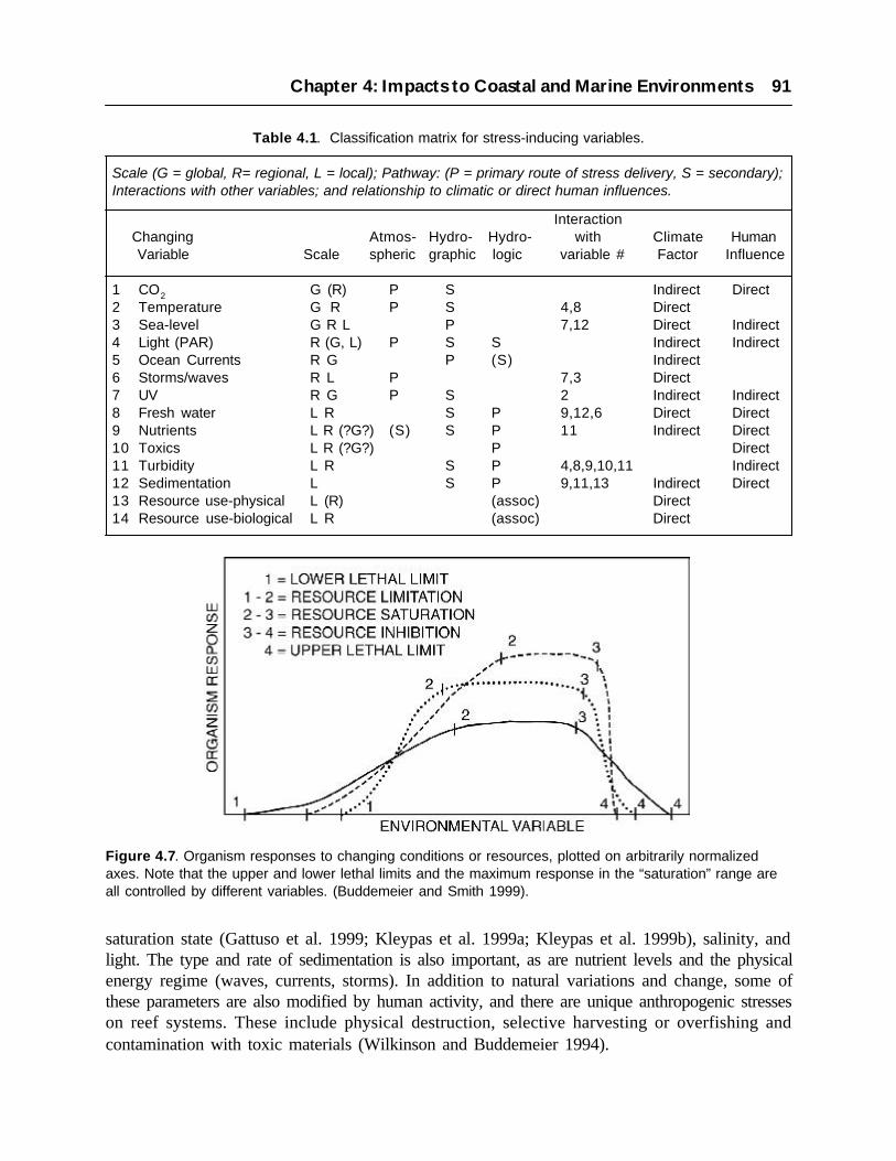
saturation state (Gattuso et al. 1999; Kleypas et al. 1999a; Kleypas et al. 1999b), salinity, andlight. The type and rate of sedimentation is also important, as are nutrient levels and the physicalenergy regime (waves, currents, storms). In addition to natural variations and change, some ofthese parameters are also modified by human activity, and there are unique anthropogenic stresseson reef systems. These include physical destruction, selective harvesting or overfishing andcontamination with toxic materials (Wilkinson and Buddemeier 1994).
Chapter 4: Impacts to Coastal and Marine Environments 91
Figure 4.7. Organism responses to changing conditions or resources, plotted on arbitrarily normalizedaxes. Note that the upper and lower lethal limits and the maximum response in the “saturation” range areall controlled by different variables. (Buddemeier and Smith 1999).
Table 4.1. Classification matrix for stress-inducing variables.
Scale (G = global, R= regional, L = local); Pathway: (P = primary route of stress delivery, S = secondary);Interactions with other variables; and relationship to climatic or direct human influences.
InteractionChanging Atmos- Hydro- Hydro- with Climate Human Variable Scale spheric graphic logic variable # Factor Influence
1 CO2 G (R) P S Indirect Direct2 Temperature G R P S 4,8 Direct3 Sea-level G R L P 7,12 Direct Indirect4 Light (PAR) R (G, L) P S S Indirect Indirect5 Ocean Currents R G P (S) Indirect6 Storms/waves R L P 7,3 Direct7 UV R G P S 2 Indirect Indirect8 Fresh water L R S P 9,12,6 Direct Direct9 Nutrients L R (?G?) (S) S P 11 Indirect Direct10 Toxics L R (?G?) P Direct11 Turbidity L R S P 4,8,9,10,11 Indirect12 Sedimentation L S P 9,11,13 Indirect Direct13 Resource use-physical L (R) (assoc) Direct14 Resource use-biological L R (assoc) Direct

Table 4.1 is an updated summary of potential individual stressors and the pathways of stressdelivery developed by Smith and Buddemeier (1992); the scale terminology follows Buddemeierand Hopley (1988). The atmospheric and hydrographic (oceanographic) pathways are valid for allreefs, but the hydrologic pathway is primarily relevant to reefs close to larger land masses. Sincemany anthropogenic effects are also related to proximity of human populations, there arerelationships among the hydrologic pathway, direct anthropogenic stresses, and the local to regionalscale.
These environmental conditions and stresses may interact in complex and synergistic fashions. Aresponse to a single environmental variable may be depicted in the form often used for resourceresponses, as there are upper and lower lethal limits, ranges of limitation and inhibition, and asaturation interval (or optimal response range). Figure 4.7 illustrates a suite of idealized responsecurves to these stressors. With the horizontal axis as a normalized index of environmental suitability,multiple parameters may control organism (or community) responses, with each playing a dominantrole under a different range of conditions.
An illustration of both stress interactions and the problem of predictions across different timescales is provided by the combination of acute and chronic stresses (Hughes and Connell 1999;Kinsey 1988). Coral reef communities are generally regarded as stress-adapted, and have beenfrequently cited as supporting the Intermediate Disturbance Hypothesis, with disturbance playinga key role in sustaining their overall high biodiversity (Connell 1997). This implies that reefcommunities destroyed or damaged by acute episodic events will generally recover if theenvironment remains generally favorable. On the other hand, reef organisms and communitiesmay persist under suboptimal conditions for a protracted period in the absence of acute stresses.This is particularly the case if the chronic stress affects primarily competitive fitness, reproduction,or recruitment, as the reef community may appear healthy and flourishing even to professionalscientists. However, once a chronically stressed reef is acutely damaged, recovery is very unlikely(Hughes 1994). This is an important issue, since any increase in human activities will tend toincrease chronic stresses such as nutrient loading and overfishing, while climate-related acutestresses such as high-temperature episodes are also likely to increase as a result of global change.
Viewed in a geological context, corals and their communities appear to be survivors; theirevolutionary history goes back over 200 million years to a time period that includes majorenvironmental changes and extinction events (Veron 1995). Since their origins, reefs have waxedand waned in abundance and character, but have survived a very wide range of conditions andnatural stresses. Why then is there such great concern at present? There are two answers, bothrelating to human society. One is that the present combination of stresses is without naturalprecedent. Completely unique chemical challenges by globally distributed synthetic moleculesare combining with widespread physical disruption and a sustained rate of climate change greatlyaccelerated by human activity. Reef organisms appear to have good adaptive or acclimativemechanisms (Buddemeier et al. 1997; Gates and Edmunds 1999). However, they have not evolvedwith or been tested by the challenges of the sort now being presented; for example, it appearslikely that the chemical and physical characteristics of the late 21st century may be more akin to
92 The Potential Consequences of Climate Variability and Change

the early Eocene than to any conditions experienced during the past 60 million years of Cenozoicreef development (Opdyke and Buddemeier submitted). The other reason is that from the standpointof human benefit, long-term survival of the genetic basis for a resource is of little short-termpractical benefit if the resource itself, be it a fishery, a living breakwater or a tourist attraction, isgone. The difference between global extinction and local extirpation is vast and important, butrather academic to communities who might have lost “their” reef.
Many anthropogenic stresses that might at first be assumed to be strictly local can have a strongregional effect, through two different mechanisms. Hydrologic and hydrographic processes canreflect distant environmental changes, as in the well-documented case of hypoxia near the mouthof the Mississippi River, a response to cumulative urban and agricultural activities over a continentalwatershed extending for thousands of miles. Also, the fact that populations of many reef speciesdepend on recruitment of long-lived larvae from distant sources means that a seemingly localepisode of reef destruction may eliminate the source population of an important species for a largearea. The needs for effective management and regulation transcend jurisdictional boundaries inmany cases.
Chapter 4: Impacts to Coastal and Marine Environments 93
Figure 4.8. Effects of increasing CO2 on coral calcification rates. Increasing levels of atmospheric CO2.Houghton et al. (1996) are projected to decrease carbonate ion concentrations in seawater, likely resultingthe calcification rates of many reef-building species (Gattuso et al. 1999).

94 The Potential Consequences of Climate Variability and Change
Figure 4.9. Maps of aragonite saturation state distribution based on the model results of Kleypas et al.(1999a). Locations of present reefs and reef communities are shown (www.cgiar.org/iclarm/resprg/reefbase/frameg/). Classification intervals for saturation effects on reef systems are derived from Kleypaset al. (1999b).

Chapter 4: Impacts to Coastal and Marine Environments 95
Figure 4.10. Annual areal extent of unusually warm (>2°C over usual high temperatures) sea surfacetemperatures in tropical seas. Widespread and severe coral bleaching has been associated with periods ofunusually warm temperatures, often associated with El Niño conditions (Strong et al. 2000).
4.4.3 Impacts of Globally Consistent Changes
Variables in this category include CO2 concentrations (atmospheric and surface ocean), temperature,and eustatic sea level. All are projected to increase monotonically on a global scale over thecoming century. This does not mean that changes will be uniform; there will certainly be local andregional variations, especially in temperature and local relative sea-level patterns. However, theirconsistency justifies common discussion before proceeding to local and regional assessment issues.
Atmospheric CO2
Although it had been posited earlier, only recently have experimental evidence and empiricalobservations been developed to demonstrate that the calcification rates of reef organisms aresensitive to the mineral saturation state of the ambient water, and that the saturation state is reducedas a result of equilibration with rising atmospheric concentrations of CO2. The mechanism for thisimpact is that carbon dioxide acts as an acid when dissolved in seawater, causing seawater to beless alkaline. A drop in alkalinity subsequently decreases the saturation state, or the amount ofcalcium carbonate (aragonite) which can be dissolved in seawater (and is subsequently availableto marine organisms). This, in turn, decreases the calcification rates of reef-building corals andcoraline algae. Although the database is still scanty, both organism and mesocosm experimentssuggest that reef calcification rates may decline by 17 to 35% by the year 2100, as shown in Figure4.8. Additionally, this research suggests that roughly a third of that decrease may already haveoccurred (Gattuso et al. 1999; Kleypas et al. 1999a).

These effects are shown Figure 4.9, which presents maps of preindustrial, present and projectedfuture surface ocean aragonite saturation states, derived from the model results of Kleypas et al.(1999a,b). These maps depict the location of present-day reefs and reef communities, which areused to assess desirable levels of saturation state for coral reef maintenance.
If expressed as reduced skeletal density, a lowered calcification rate will increase vulnerability tophysical damage, bioerosion, and some forms of predation. If it results in reduced extension (growth)rates, the reduction will impair the abilities of calcifying organisms to compete for space, both interms of substrate dominance and with respect to harvesting particulate food and incident light.This is a major impact on the overall fitness of communities and organisms subject to other stresses.Additionally, the effects of increasing atmospheric carbon dioxide on the concentration of carbonateions is greatest at the margins of coral distributions, due to the fact that carbon dioxide is moresoluble in cooler waters. Thus, these effects will be most severe at higher latitudes, such that coralreefs at the margins of their distribution probably will not expand their ranges as might otherwisebe predicted by some ocean warming scenarios.
Temperature
Seasurface temperatures might be expected to rise by some 1 to 3°C over the coming century, witha non-uniform distribution of increases (see Section 3.1; also Pittock 1999). The rate of increase islikely to be of the same magnitude as, but probably somewhat greater than, the warming trend ofthe past several decades. Events in recent decades have already culminated in widespread reefstress caused by coral bleaching, the disruption of the coral-algal symbiosis, associated with recenthigh-temperature episodes.
The increase in mean temperature may be considered a net neutral change, disadvantageous toreefs on the high side of the temperature optima, but potentially advantageous to those on the lowtemperature margins; which include many of the U.S. reefs. However, this effect is overwhelmedby the negative impacts of increasing frequency and magnitude of high temperature events, whichhave resulted in the widespread and damaging bleaching episodes of the past two decades. Howgreat will this effect be? The answer depends on the scenario adopted. If the high-frequency SSTvariation of the past 20 years continues and is superimposed on a general warming trend theacceleration of bleaching occurrence would result an expanding degradation and near-completedestruction in many areas. Figure 4.10 demonstrates the apparent increasing trend of equatorialocean hotspots, which have been associated with coral bleaching and die-offs, over the last 20years. Treating the extreme variations as a random phenomenon suggests a possibility of greaterintervals between extreme events, and there may be some theoretical basis for that expectation(Kerr 1999). However, in no case does this translate to a return to previous conditions. The questionis whether the next damaging temperature episode will occur in a few years, or in a few decades.
96 The Potential Consequences of Climate Variability and Change

Sea-level Change
As discussed in Section 3.5, eustatic sea level is expected to rise by more or less 1.6m over thiscentury. This rate, like temperature, is similar to but somewhat greater than that observed in therecent past. However, the direct effects, assessed at a global scale, are likely to be somewhatpositive for near-sea-level reefs, many of which have developed large areas that are sea levellimited due to the protracted Holocene still-stand. Sea-level rise may open up reef flats and otherareas for colonization, in locales where there is a ready source of suitable substrate for coralcolonization. Increasing sea level will be a disadvantage for extremely marginal deeper reefs;those near the bottom of the depth range of viability which typically calcify or accumulate veryslowly.
Sea-level rise may have indirect negative effects locally if increasing coastal erosion mobilizessediments that are subsequently deposited on nearshore reef areas or coral communities. Issuesrelating to erosion and sedimentation interact strongly with land use and management practices,and predictions must be based on detailed local assessments that include projected human activities.
Chapter 4: Impacts to Coastal and Marine Environments 97
Table 4.2. Anthropogenic stresses on coral reef systemsand scale of their effects (R, regional; L, local).
Category Activity Primary Agents Source scale Effect scale
1 Land Use a. Agriculture Nutrients, biocides, sediment, R, L R, Lhydrologic alteration
b. Land clearance Sediment, hydrologic alteration, R, L L, Rnutrients
c. Urbanization Hydrologic alteration, nutrients,toxics, sediments, category 2 activities
2 CoastalModification a. Construction Sediment, hydrologic/hydrographic L L, R
alterationb. Dredging Sediment, hydrographic alteration, L L, R
destructionc. Landfill Sediment, hydrographic alteration, L L, R
destructiond. Quarrying Destruction, sediment, hydrographic L L
alteration
3 Harvest a. Fisheries Trophic ecosystem disruptions L, R R, L
b. Collection Trophic ecosystem disruptions, L, R L, Rdestruction, extirpation
c. Incidental Destruction, extirpation L, R L, R damage
4 Tourism Multiple Potentially 1bc, 2abc, 3abc L, R R, L

4.4.4 Impacts of Local and Regional Changes
Many of the known or anticipated environmental changes due to climate change are local orregional manifestations that cannot be described in global terms. Among these are ocean circulationpatterns, storm frequency and intensity and precipitation patterns. To the extent that regional modelpredictions are available, these can be addressed for specific areas; however, some usefulgeneralizations are possible.
Ocean circulation will be primarily relevant to the longer-range transport of propagules andpathogens. Significant changes are likely to be detrimental to existing reefs that depend on upstreamsources for recruitment, but there is possible advantage if predators or pathogens are an importantcomponent of the recruits. Storm frequency and intensity is projected to increase by some (Pittock1999), or to shift their geographic pattern; although this is by no means certain. An increase instorm incidence or intensity would be of little significance in an ideal natural setting, but whenimposed on reefs already damaged and under multiple chronic stresses, it represents a seriousadditional threat. Finally, precipitation and runoff are expected to increase in many (but not all)areas; where this does occur it will likely result in decreased salinity and increased sediment, bothof which will result in additional stress to reefs that are close to larger land masses.
Other locally and regionally important variables may have natural climatic components or modifiers,but are primarily dominated by human activities. Freshwater effects and nutrient and sedimentloading are all heavily dependent on land use and watershed modification; all have been increasingin general as have fishing pressure, recreational activities, ship groundings, anchor damage andother direct impacts on reef communities. In view of predictions of continued population growthand economic development, most of these can be expected to continue to increase. Of these variables,sediment and freshwater stresses will be most important relatively close to the coastlines ofsubstantial land masses (large islands or continents), where there is reason for suspicion that nutrientloading may affect the larger coastal zone and marginal seas (Jickells 1998; Moffat 1998).Anthropogenic stresses tend to correlate with human population (density, proximity and economicstatus), and are thus likely to increase in the absence of specific and effective protective measures.
Table 4.2 summarizes the major categories of human activities that are recognized as havingdeleterious effects on reef ecosystems and habitats on a wide-spread basis. Not all of the activitiesare strictly coastal; however, in many areas there is accelerating pressure from coastal zone activitiesbecause of the disproportionately high population densities and rates of development and populationincrease in the coastal zone. These interact with and reinforce the negative effects of climatevariability and climate change and global environmental alteration, some of which represent thecumulative effects of human activities at the global scale.
The sequence of classification proceeds from activities in which reefs are commonly not consideredat all (land use), through those in which reef systems are incidental considerations (coastalmodification) or are substrates or sources for the resource of interest. The final category, tourism,is used here to subsume essentially all recreational and aesthetic values for which identity as acoral reef system is central. Tourism exemplifies the dilemma of balancing economic yield against
98 The Potential Consequences of Climate Variability and Change
the poorly quantified, but very real, synergistic effects of multiple stresses. Increases in land-based development and population, as well as increases in extractive activities and the wear andtear associated with high levels of visitation, can cumulatively destroy the critical resource eventhough the levels of any individual stress, considered alone, can be argued to be within tolerablelimits. This is an issue any time multiple stresses coincide.
4.4.5 Symptoms and Conditions
The proliferation of concerns and observations about coral reef conditions has led to an explosionof information that has outpaced traditional publication practices. A number of recent, electronicallydisseminated reports address reef conditions and factors affecting them (including: Miller andCrosby 1998; U.S. Department of State 1999; Jameson et al. 1995; Hoegh-Guldberg 1999;Wilkinson 1998). The interpretive tenor of these reports ranges from relatively optimistic to direlypessimistic, but they approach consensus in recognizing that many (some say most) reefs areshowing signs of human impacts, a significant number of reefs are already destroyed or seriously
Chapter 4: Impacts to Coastal and Marine Environments 99
degraded, and that the potential for continued or increased stress is high. Because of a naturalfocus on readily observable signs of stress, two themes (or symptoms) are called out for particularattention.
The term “bleaching” is commonly applied to the loss of some or all of a coral colony’s algalsymbionts. Although it occurs to some degree in healthy corals in natural settings, it is also ageneral stress response that can result in mortality (Brown 1997). Reports of extensive and damagingbleaching events have been increasing since the early 1980s. Many of the most wide-spread andsevere episodes of bleaching have been associated with periods of unusually warm temperaturesassociated with clear, calm weather, resulting in combined temperature-irradiation stress. Theseare often but not always associated with El Niño conditions; the most widespread and devastatingoccurrence was in 1998, when areas of the Indo-Pacific that had not previously experienced major
Table 4.3. Classes of U.S. coral reefs by region (Veron, 1995).
L = Land (reefs sufficiently close to a continent or large island coast so that terrigenous effects are likely tobe significant); O = Oceanic (outer shelf, atolls, or small island reefs, oceanic reefs or banks).
Eastern Pacific Subtropical: (L) Hawaiian islands; (O) Hawaiian chain, Midway, Wake atollsEastern Pacific Tropical: (O) Johnston Atoll, Palmyra Atoll, Jarvis Island, Kingman Reef
Central Pacific Tropical: (L) American Samoa (high islands), Howland and Baker Is.,Guam, N. Marianas (some); (O) Swains Reef, Rose Island,N. Marianas (some)
Western Atlantic Subtropical: (L) Florida (incl. Keys), (O) Dry Tortugas, Flower Garden banks
Western Atlantic Tropical: (L) Puerto Rico, U.S. Virgin Islands.
bleaching suffered severe damage (Berkelmans and Oliver 1999; Wilkinson et al. 1999; Strong etal. 2000). While the relationship between El Niño conditions to general global warming is stillunder discussion (Kerr 1999), the existence of a global warming trend is well-demonstrated, andcan be expected to result in increased frequencies and magnitudes of high-temperature events.
Another of the more disturbing and poorly understood features of the recent decline in reefs andcorals has been the increased frequency, virulence, and variety of lethal epizootics among reefcorals (Harvell et al. 1999). Population explosions of predatory macro-organisms (such as theCrown of Thorns starfish) have been an issue in the Indo-Pacific for several decades, but withinthe past decade there has been a sharp rise in reports of diseases caused by bacterial, fungal, and/or viral agents, especially in the Caribbean and Florida (Harvell et al. 1999; Done 1999). Thelarge-scale coral loss and community shifts associated with these diseases seem to be unprecedentedin Holocene and Late Pleistocene time (Aronson et al. 1998; Greenstein et al. 1998). The introductionof new pathogens into the marine environment, the alteration of environmental conditions to favorthe propagation of existing disease-producing agents, and the general debilitation of coral “health”that makes them more vulnerable to infection all appear to play a role in this phenomenon. Althoughthe relative importance of these factors is not yet known, the extent and novelty of the epizooticphenomenon clearly implicates significant environmental change at the regional or global scale,and offers little basis to expect that conditions will improve.
4.4.6 U.S. Reefs: Characteristics, Vulnerability and Future Prospects
Table 4.3 summarizes the biogeographic regions and relationships to land masses of U.S. reeflocations. Pacific subtropical regions are commonly marginal with respect to temperature,seasonality, and saturation state, and tend to have lower biodiversity. Biodiversity and proximityto other reef systems are lower in the eastern than in the central and western Pacific. U.S. Pacificreefs vary in their relationship to storm zones, equatorial upwelling, and El Niño effects, andinclude no shelf reefs. In the western Atlantic, all U.S. reefs are within the hurricane zone, and allsubtropical reefs are continental shelf reefs. Overall, one of the most important distinctions is thequestion of “land” vs. “ocean” status, as proximity to major land masses generally corresponds togreater human exploitation or environmental impacts. This in turn indicates greater vulnerabilityto the suite of environmental stresses related to the hydrologic pathway.
Additionally, U.S. reefs are described, and their conditions assessed, by Miller and Crosby (1998),Reefcheck (http://www.ust.hk/~webrc/ReefCheck/reef.html) and the Global Coral Reef MonitoringNetwork (http://coral.aoml.noaa.gov/gcrmn/gcrmn.html). One of the most telling conclusions tobe drawn from the assessments of Miller and Crosby is that almost all of the reefs identified asbeing in reasonably good condition are remote and isolated from human populations. The degradedreefs have typically suffered from some combination of natural and anthropogenic stresses, butthe variable that sets them apart as a class is the intensity of human use and environmental alteration.This reinforces the notion that corals and reef communities have considerable adaptive andacclimative ability to deal with the effects of natural change and variability, but that the novelcombination of those stresses with qualitatively different anthropogenic stresses has pushed manyreef ecosystems or regions across a critical threshold. These observations further highlight the
100 The Potential Consequences of Climate Variability and Change

dilemma that it is precisely those reefs that are most used and most economically valued that are atthe greatest risk and most difficult to save.
4.4.7 Projected Future Changes
The calculus of coral reef system stress in the 21st century is straightforward. Human populations,especially coastal populations, will continue to rise; pressures for economic development will notabate; and atmospheric concentrations of CO2 (and presumably other greenhouse gases as well)will continue to increase. This means that anthropogenic alterations of the hydrologic and nutrientfluxes will continue, that the earth’s radiant energy balance will continue to change, that the surfaceocean will become less supersaturated with respect to carbonate minerals, and that, in all probability,the global climate will warm and the hydrologic cycle accelerate. The U.S. is not exempt fromthese generalizations; global CO2 projections (and their effects on calcification) will be felteverywhere. Population projections presented in section 2.1 indicate that coastal counties in Hawaiiand south Florida will experience population increases of 20 to 50% over the next 25 years.
These changes all imply additional stresses on coral reef systems, either global or episodicallylocal. Many of these stresses will interact synergistically. On average, the environment is becomingless hospitable to reefs, with the effect most pronounced in reefs in close proximity to humanpopulations. There will be a great deal of variation around the overall trend, but averaged overspace and time, it seems clear that the observed trend of reef degradation will continue, and probablyaccelerate. This is exemplified by the projected changes in aragonite saturation state (Figure 4.9),which suggest that conditions for calcifying reef organisms will become systematically moresuboptimal of the coming decades — an effect almost certain to reduce there resilience in the faceof other increasing stresses.
This does not mean that all reefs are doomed, but the implication is strong that many of the reefsabout which people care (from the standpoint of use for various purposes) are poor candidates forsurvival. The prospect are sufficiently bleak that they raise the question of whether some reefsshould be “written off” and environmental protection and restoration programs focused elsewhere.This approach may appear rational if coral reef ecosystems are somehow separable from the largersuite of interacting coastal environments, but they are not. Where reef communities are importantecosystems they provide characteristics and interactions that are linked to other communities andfeatures of the environment. Some of their key functions cannot be provided by any other ecosystem,and their health is not an isolated problem but a symptom of the condition of the coastal (oroceanic) environment.
Synergy of stresses and the response time scales involved make integrated management essentialbut difficult. The range of reef types and locations, continuum between reef and non-reef habitats,and competitive succession as a mechanism of community failure all point to the need for broadlybased, integrative management, conservation, and research. Given trends already in motion, someof the more marginal reef systems will almost certainly continue to deteriorate, making allocationof resources an important policy issue.
Chapter 4: Impacts to Coastal and Marine Environments 101
Case Study: Kaneohe Bay, Oahu, Hawaii
The coral reef system of Kaneohe Bay represents one of the best-documented examples ofreef response to, and recovery from, anthropogenic stress (Miller and Crosby 1998; Smith etal. 1981). The Bay is a relatively enclosed feature on the seaward side of a collapsed volcaniccaldera, a feature that serves to funnel freshwater discharge toward the bay, which results incoral kills when high rainfall and low tide coincide. Urbanization of the watershed over thelast half-century further modified the hydrology and increased point- and non-point-sourcepollution loads, resulting in massive algal blooms and coral loss in the early 1970s. In 1978-79the local sewage discharge was redirected from the Bay to a deep-water outfall, and the coralcommunities recovered rapidly over the subsequent decade. Throughout the 1990’s there hasbeen an ongoing debate about whether the reef communities have recovered, stabilized, or arebeing subject to renewed or increasing levels of stress.
Hawaiian reefs are generally regarded as marginal, having relatively low biodiversity andcarbonate accumulation rates. However, they are by no means at the extremes of reef occurrencein the Northeast Pacific; the Hawaiian chain extends to Midway and Kure Islands, whichsupport coral communities at considerably higher latitudes. The analysis by Kleypas et al.(1999a) would suggest that corals in Hawaii may already be experiencing reduced calcificationrates as a result of increasing atmospheric carbon dioxide and subsequent decreasing oceanicsaturation states for calcium carbonate (see section 4.4.3). This also implies that stress fromthis source is essentially certain in the future.
Bleaching has occurred in Hawaii, although not at catastrophic levels, and it is reasonable toassume that this source of coral stress will continue, if not intensify, as climate warms. Itappears unlikely that wave and storm-surge damage will see a major increase, but the expectedintensification of the hydrologic cycle may lead to more and larger rainfall events; a knownstressor of Kaneohe Bay reefs in the past. Population, urbanization, and marine resource useare expected to continue as well, which will probably exacerbate hydrologic problems andincrease non-point-source pollution loads. The geomorphic and geographic setting is such thatit would be extremely difficult to ameliorate the terrigenous and anthropogenic forces actingon the Kaneohe Bay ecosystem.
The coral reefs and communities of Kaneohe Bay may thus be expected to experience anincreased frequency and intensity of acute stress episodes (salinity and temperature excursions)operating against a backdrop of increased chronic stress (reduced calcification potential,resource use and pollution loading), with “natural” global factors and local anthropogenicforces combining in both categories. As pointed out by Hughes and Connell (1999), the detailedtrajectory of the system will depend on the exact sequence and history of events and conditions.However, unless the projections are very wrong or there is something surprisingly resilientabout these reef communities, the general expectation is clearly that Kaneohe Bay coral reefcommunities will undergo significant decline in the coming decades.
102 The Potential Consequences of Climate Variability and Change

4.5 OCEAN MARGINS AND FISHERY RESOURCES
Changes in climate will have important effects in ocean margin ecosystems through expectedchanges in the distribution and abundance of marine organisms and in fundamental changes in theproduction characteristics of these systems. Alterations in temperature, precipitation, wind fields,and sea level can all be expected to affect oceanographic conditions in the ocean margins withdirect ramifications for marine life in these areas. Physiological effects of temperature and salinitychanges can also be expected with important consequences for growth and mortality of marinespecies.
Projected changes in the marine environment also have important implications for fisheriesresources. Marine commercial and recreational fisheries support a multibillion dollar industry inthe United States (see section 2.2). In particular, the development of the Alaska pollock fisheryhas resulted in substantial increases in total landings over the last decade. In addition to this economicvalue, marine fisheries hold a significant social and cultural significance in many coastalcommunities. The possible effects range from shifts in distribution that may result in changes inavailability of key resource species to changes in vital rates, including survival, growth, and maturitywith direct implications for overall levels of abundance and, ultimately, fishery yields.
Impacts to marine ecosystems and fisheries associated with El Niño events illustrate the extent towhich climate and fisheries can interact. For example, the high sea surface temperatures andanomalous conditions associated with the 1997-98 El Niño had a tremendous impact on marineresources off of California and the Pacific Northwest. Landings of market squid, California’slargest fishery by volume and second largest in value, fell from over 110,000 metric tons in the1996-97 season to less than 1000 metric tons during the 1997-98 El Niño season. Among themany other events associated with this El Niño were high sea lion pup mortalities in California,poor reproductive success in seabirds off of Oregon and Washington and catches of warm-watermarlin off of the Washington coast. Even farther north were rare coccolithophore blooms, massiveseabird die-offs along the Aleutian Islands and poor salmon returns in Alaska’s Bristol Bay sockeyesalmon fishery (Macklin 1999).
4.5.1 Effects of Temperature Changes
Changes in temperature can have important impacts on marine organisms including altereddistribution patterns, changes in physiological state of individuals, alterations in food web structure,and the incidence of disease. Selected examples of each are given below.
Distribution
Poleward shifts in distribution of marine populations can be expected with increasing watertemperatures (Frank et al. 1990; Murowski 1993). Such changes in species composition in intertidalcommunities at long-studies locations along the California coast have already been documented
Chapter 4: Impacts to Coastal and Marine Environments 103

(Sagarin et al. 1999). Species temperature preferences and overall habitat requirements (for examplesubstrate type, prey and predator abundances, etc.) will determine the extent of potentialdistributional shifts. Frank et al. (1990) indicate that certain fish species at the southern extent oftheir range off the east coast of North America can be expected to shift their distribution to thenorth with important overall consequences for ecosystem structure in this region. Cod, Americanplaice, haddock, Atlantic halibut, redfish and yellowtail flounder would all be expected to experiencesome poleward displacement from their southerly limits in the Gulf of Maine and off New Englandunder increasing water temperatures.
An expansion of species commonly occurring in the Mid-Atlantic region, such as butterfish andmenhaden into the Gulf of Maine, can also be expected. Colton (1972) notes that for some species,the habitat requirements related to spawning and nursery areas can constrain the response to changesin the thermal environment thus limiting the possibility of adjustment. Loss of populations orsubpopulations with shifts in temperature under these constraints is therefore possible.
Hobrook et al. (1997) documented changes in the assemblage structure of temperate reef fishescoincident with a shift in temperature regimes off California in 1976-77. Here, an increase intemperature was associated with a shift in dominance by southern species, a decrease in speciesrichness, and an overall decrease in abundance. Looking towards future changes, Welch et al.(1998) concluded that projected changes in water temperatures in the North Pacific may result ina virtual elimination of suitable thermal habitat for sockeye salmon (see Pacific Salmon casestudy). Important impacts on changes in the thermal habitat on steelhead trout have also beendocumented (Welch et al. 1998b). Kruse (1998) noted that marked increases in water temperatures
104 The Potential Consequences of Climate Variability and Change
Figure 4.11. The Pacific Decadal Oscillation (PDO) index (five-year moving average) and landings ofCalifornia sardine in British Columbia, Oregon and Washington (PNW) between 1900 and 1960 andCalifornia from 1977.

during 1997-98 apparently affected runs of salmon in western Alaska, resulting in sharp declinesin numbers of fish returning to home streams and river systems.
Changes in sardine and anchovy populations also appear to be linked to changes in temperature ona global basis (Lluch-Belda et al. 1992). The California sardine fishery developed in the earlydecades of this century and landings rapidly increased during the 1930’s. By the early 1950’showever, the fishery had collapsed under increasingly intense fishing pressure and broad scalechanges in environmental conditions (Radovich 1982). The decline in the fishery coincided withsignificant changes in environmental conditions, and a sharp decrease in the recently describedPacific Decadal Oscillation (PDO) index (Figure 4.11). Following a subsequent shift to a positivephase in the PDO after 1976, and significant warming of average sea surface temperatures in theCalifornia Current the California sardine population began to show some signs of recovery. Dueto a small initial population, the total biomass remained relatively low until about 1990; howeverover the last decade the sardine population has undergone a tremendous resurgence. Currentestimates of biomass range well over 1 million metric tons (Barnes et al. 1997), and sardines areagain migrating northwards as far as Vancouver Island in the warm summer months (Hargreaveset al. 1994). Similarly, the commercial fishery has begun to revive; quotas have been as high as100,000 metric tons in recent years and sardines have again been the target of a growing fishery inMonterey Bay.
In addition to latitudinal shifts in distribution, shifts in the relative distribution with respect todepth and distance from shore may occur. Collectively these changes in distribution with respectto latitude or depth will affect the availability of fish and invertebrate species to regional fisheries,in some instances changing the community structure and the character of these fisheries. Adaptationto these changes will include alteration in the species mix harvested in different areas and possiblechanges in fishing areas. Changes in management strategies and in allowable exploitation levelswill be required under persistent shifts in environmental conditions and the productivity of exploitedresources.
Food Web Dynamics
Temperature changes that affect the relative timing of the production cycles of predators and theirfood sources may also affect their growth and survival rates if a mismatch occurs between thetiming of the seasonal primary production cycle and the spawning cycle of fish and invertebrates.The primary production cycle is principally controlled by day length and nutrient availability;however, the spawning periods of fish and other species may be controlled by temperature levels.Temperature changes may also result in regional changes in the species composition ofphytoplankton and zooplankton species, affecting the availability and suitability of prey for highertrophic level species, including those of commercial importance. Murawski (1993) reported thatsubstantial shifts in the distribution of small pelagic fishes such as herring and mackerel off theEast Coast of the United States can be expected based on observed temperature-dependentdistribution patterns. These species provide an important forage base for many piscivorous (fisheating) fishes, marine mammals and sea birds; strongly suggesting that temperature changes mayhave secondary effects on trophic interactions and the relative distribution of prey and predators.
Chapter 4: Impacts to Coastal and Marine Environments 105

Physiological Considerations
Temperature is a dominant controlling factor in the physiology of most ectothermic (cold blooded)marine organisms. Growth rates of fishes and invertebrates are strongly linked to ambienttemperature. Growth rates during the early life stages often play an important role in vulnerabilityto predation with faster growth rates resulting in more rapid passage through smaller sizes classesat greatest risk of predation. For example, Marshall and Frank (1999) documented a positiverelationship between growth of haddock and recruitment success. Brander (1995) found a similareffect for cod, where growth rate was found to be positively related to temperature. The growth atlater stages can affect the overall reproductive output because fecundity is often a direct functionof size.
For most species, we assume that an optimum temperature range exists (Jobling 1996), affectinggrowth and metabolism. Increases in temperature toward the optimum for these species can beexpected to result in enhanced growth, survival, and reproductive output. However, furthertemperature increases beyond the optimum range will result in adverse impacts on vital rates. Forexample, Cox and Hinch (1997) showed that high, sub-optimal temperatures are related to reducedgrowth rates in Fraser River sockeye salmon, presumably due to increased metabolic demand orchanges in food availability. Size at maturity was found to be lower in warm water periods.
The potential effects of changes in temperature may be particularly severe for sessile species thatexhibit little mobility at one or more stages of the life cycle. Many commercially importantinvertebrate species (particularly shellfish) could be so affected. Dramatic effects on corals as aresult of the loss of symbiotic algae at high temperatures (coral bleaching) are documented insection 4.4 and would presumably lead to changes in productivity of fish species in such regions.
Disease and Harmful Algal Blooms
A weakening in the immune system of individuals stressed by higher than optimal temperatureshas been linked to epidemics in marine populations. Outbreaks of diseases of marine organismsconcurrent with changes in temperature levels have been documented in a number of instances(HEED 1998). For example, diseases affecting sea urchins have been documented under unusuallywarm water temperatures in both tropical and temperate waters. Changes in the abundance of seaurchins have subsequently been associated with impacts to marine ecosystems, as the grazingpressure by urchins on benthic algae was altered with cascading effects throughout the system.
The northward extension of the shellfish diseases, such as the oyster pathogens Minchinia nelsoniand Perkinsus marinus, has been linked to increases in temperature levels. It has also postulatedthat epidemics in seabird populations and disease-related marine mammal strandings were alsorelated to ENSO events and associated warm water temperatures (Harvell et al. 1999).
Harmful algal blooms have been associated with ENSO events and increased water temperatures(Hallegraeff 1993). The prevalence and intensity or red and brown tides appears to have increasedover the last several decades (Anderson 1995). Increased water temperature and decreased vertical
106 The Potential Consequences of Climate Variability and Change

Chapter 4: Impacts to Coastal and Marine Environments 107
mixing of the water column can contribute to the growth of toxic algae and changes in the level oftoxicity of algal species can occur with changes in nutrients.
4.5.2 Sea Ice and Arctic Ecosystems
Increases in temperature will result in melting of sea ice in polar and subpolar regions with directeffects on the input of freshwater into these systems, and on the convective processes which arecritically important to primary production in Arctic systems. It is increasingly recognized that theunderside of sea ice is an important substrate for ice algae, which supports an active biologicalcommunity (Wheeler et al. 1996). Perhaps more importantly, ice edges have been demonstrated tobe highly productive regions where interactions between physical and biological processesencourage substantial phytoplankton blooms and subsequently support zooplankton and arcticcod production (Niebauer 1991). The migrations of belugas, narwhals and harp seals to ice edgeregions have all been linked to bursts in the productivity and subsequent abundance of Arctic codin these areas during summer plankton blooms.
Although it is unclear exactly how a reduction in sea ice will affect the productivity of importantprey species such as arctic cod, it has been speculated that a sufficient reduction in ice edge extentwould have deleterious consequences for marine mammal species which depend upon these systems(Tynan and Demaster 1997). Climate induced regional changes in the flux of organic materialfrom ice or water-column production to benthic communities might also affect the distributionand reproductive success of benthic feeding marine mammals such as gray whales, walruses, andbearded seals (Tynan and Demaster 1997). Declines in many of these populations could in turnlead to a reduction in the availability of prey for top level predators such as polar bears and orcas.
In addition to potential changes in the productivity of ice edge regions, the loss of sea ice wouldhave additional direct consequences through the loss in critical habitat for marine mammals andseabirds that use ice shelves and flows as platforms for daily activities such as reproduction,pupping, resting, molting and migration. Walrus in particular are especially vulnerable to changesin sea ice extent, as floating ice provides walrus with a means of transportation and allows them tofeed over large areas (Alexander 1992). Ringed seals depend upon the stability of fast ice forraising their young; they and the polar bears which prey upon them are the only marine mammalsthat regularly occupy landfast Arctic ice (Tynan and Demaster 1997) and would presumably begreatly affected by a reduction of sea-ice extent poleward. Because polar bears require ice as asolid substrate for hunting ringed seals and other prey, Stirling (1997) predicted that some of thefirst observable impacts of climate warming will occur in the southern limits of the distribution ofpolar bears where prolonging the ice-free season would be likely to increase their nutritionalstress. Thus both polar bear and ringed seal populations in the eastern Beaufort Sea and in HudsonBay might be suitable indicators of significant climatic changes in Arctic ecosystems, andmonitoring of populations may provide some indication of the degree of stress induced on marinepopulations in the arctic as a result of global change. Already, anecdotal evidence suggests thatthe availability of walrus, polar bears and other marine mammals to native hunters in the Arctichas been declining (see the Alaska regional report for more details on this issue).

108 The Potential Consequences of Climate Variability and Change
4.5.3 Stratification
Increases in water temperature and precipitation under global climate change will likely result inenhanced stratification of the water column with important implications for productivity of coastalsystems. The overall effect would be to increase the energy required for mixing in the watercolumn, resulting in less turnover and a reduction in the mixed layer depth. Replenishment ofnutrients in systems dependent on enrichment of the water column from bottom waters would bedirectly affected. The consequences of these changes can be expected to vary regionally as describedbelow.
McGowan et al. (1998) attributed long-term declines in zooplankton populations in the CaliforniaCurrent to increased water temperatures resulting in an intensification of stratification and anoverall lowering of mixing and nutrient regeneration in the upper water column and a subsequentdecrease in overall levels of productivity in the system. Because zooplankton are a major foodsource for pelagic fishes, declines in secondary production may be linked to declines in fishproduction. For example, Nixon (1988) suggested that fishery yield is exponentially proportionalto primary production. A 5% reduction in primary production could result in a 6 to 9% reductionin ultimate fishery yield (Gucinski et al. 1990).
In systems in which primary production is limited by light levels at depth, however, a shallowermixed layer depth may result in enhanced production. It has been hypothesized that increasedproductivity in the North Pacific Ocean during low wind regimes is linked to changes in thestrength of the Aleutian Low Pressure System (Polovina et al. 1995). Off Alaska, this results in areduction in the mixed layer depth and a concentration of phytoplankton in the photic zone wherehigh production levels can be maintained. Conversely, during periods of higher wind stress anddeepening of the mixed layer, phytoplankton cells can be driven into zones in which light islimiting with a resulting reduction in productivity. Brodeur and Ware (1992) also documentedincreases in zooplankton abundance and production during periods of low wind stress, presumablyin response to higher levels of primary production. Increases in salmon production have in turnbeen linked to these periods of high plankton production.
In the tropical Pacific where nutrients are limiting and light penetration is high, increased mixedlayer depth is hypothesized to increase overall levels of productivity by expanding the depths towhich phytoplankton cells are distributed, providing access to more nutrients. Polovina et al.(1995) linked increases in productivity of spiny lobster and other species (including marinemammals and seabirds) to periods of higher mixing resulting from an increase in wind activity.
Frank et al. (1990) also note that increased stratification could result in reduced benthic productionin areas with important nutrient input from land sources. This would result from the trapping ofnutrients in the upper stratified area, which could result in a switch to a pelagic food web and aconcomitant reduction in the abundance of the benthic components of affected ecosystems. Thetiming and intensity of stratification can have important localized effects. Prey organisms areoften concentrated at the boundaries between water masses, and feeding success and condition offish larvae may be higher under well stratified conditions when prey are concentrated.

Chapter 4: Impacts to Coastal and Marine Environments 109
Decreased mixing can also result in changes in food web structure which could favor dinoflagellate-based primary production rather than a diatom-based structure. Because dinoflagellates are motile,they can counter sinking rates that would take them out of the euphotic zone. By contrast,dinoflagellate-based systems involve additional links in the food web and therefore are generallyless efficient than diatom-based systems. Accordingly, shifts to dinoflagellate systems can resultin some losses in trophic efficiency and transfer to higher trophic levels.
4.5.4 Wind-Driven Processes: Transport, Turbulence and Upwelling
Many marine species depend on ocean current systems for transport of their early life historystages. Among the more dramatic examples is the transport of American and European eel larvaeto the Gulf Stream from the spawning grounds in the Sargasso Sea. Similarly, longfin squid larvaeare transported from natal areas in the South Atlantic Bight northward in the Gulf Stream. Factorsthat affect the velocity and position of the Gulf Stream relative to the continental shelf regions canaffect the transport of larvae as well as other life stages and their successful recruitment to coastallocations.
A reduction in wind-driven forcing in the major current systems such as the Gulf Stream can alsobe expected to reduce the formation of meanders and rings that affect advective loss of continentalshelf biota. For example, the frequency of warm core ring formation from the Gulf Stream hasbeen related to recruitment success of a number of fish populations. In years in which a largernumber of ring events occur, recruitment is reduced, presumably due to advection as the ringsentrain water from the continental shelf and slope regions.
Many species depend on transport from spawning to nursery grounds to complete their life cycle.For example, blue crabs (Callinectes sapidus) in Chesapeake Bay spawn near the mouth of the bayand early developmental stages are completed on the adjacent inner shelf. Late stage larvae aretransported back into the bay by near-bottom currents driven by wind and buoyancy-driven flows.Successful recruitment, then, is influenced by freshwater inputs that drive estuarine circulationand coastal wind fields, both of which may be influenced by climate change.
Wind mixing also increases turbulence levels in the water column. It has been shown that turbulentmixing can increase the contact rates between zooplankton and their prey. As turbulence increasesbeyond a certain point however, the probability of successful prey capture declines. This impliesthat the probability of feeding success is dome-shaped, with a maximum at intermediate levels ofwind-speed and turbulence. The impact of changes in wind intensity must therefore be evaluatedwith respect to the optimal wind speeds and levels of turbulence. Lasker (1975) noted that foranchovy larvae in the California Bight, high wind stress is linked to lower levels of anchovyrecruitment success. This is presumably due to a dissipation of food concentrations and declinesin capture success.
Upwelling is a wind-driven phenomena as well, and upwelling zones support the highest volumefisheries on a global basis. Upwelling of nutrient rich water from depth results in high levels of

110 The Potential Consequences of Climate Variability and Change
primary production and corresponding high levels of production at higher trophic levels. Mostupwelling regions have similar characteristic fish populations and corresponding large-scalefisheries for fishes such as sardine and anchovy. For example, prior to its collapse under heavyfishing pressure and the effects of a strong ENSO event in 1972, the Peruvian anchovetta was thelargest single species fishery in the world, with catches of a single species alone approaching onefifth of the total global marine fish landings. Fisheries in such upwelling regions tend to fluctuatetremendously, and the sardine fishery mentioned earlier in this section is an important example ofsuch a system off the west coast of North America.
The potential effect of global climate change on upwelling systems has been subject to twointerpretations. Bakun (1989) hypothesized that the temperature differential between land and seawill intensify under global change scenarios, leading to an intensification of alongshore winds andresulting in an increase in upwelling. Bakun provided empirical evidence for an increase inalongshore wind stress (and a derived upwelling index) over the preceding five decades. Howeverit has also been suggested that a reduction in the latitudinal gradient of temperature due to enhancedwarning in higher latitudes will result in a lessening of wind fields, leading to an overall reductionof upwelling (Gucinski et al. 1990).
4.5.5 Implications for Fisheries Management
Factors affecting the productivity of marine resources and ecosystem structure must be directlyaccounted for in any fishery management strategy. Levels of sustainable yield and optimal levelsof exploitation are both directly tied to the state of the environment and its effects on productivity
Figure 4.12. Equilibrium yield as a function of fishing pressure under two sets of environmental conditions.The upper (solid) curve represents the production function under favorable environmental conditions,while the lower (dashed) curve represents less favorable environmental conditions.

Chapter 4: Impacts to Coastal and Marine Environments 111
of marine populations. The effects of exploitation and environmental change can be synergisticand can serve to destabilize marine populations. In particular, environmental changes that resultin an overall reduction in the productivity of a marine resource can result in the decline or collapseof a population under levels of exploitation that are sustainable only under more favorableenvironmental conditions.
Persistent shifts in productivity levels on longer time scales in particular must be taken intoconsideration in the development of management approaches. The multidecadal shifts inproductivity in the Pacific provide an important indication of the types of changes that can occurand their effects on fishery yields. Rather than consider the effects of exploitation and climatechange on marine populations as distinct and separate factors, we must instead recognize thepotential interactions among environmental forcing mechanisms and human impacts and adjustmanagement approaches accordingly. Under periods of low productivity, allowable exploitationrates must be reduced to account for reduced recruitment rates.
A simple production model will serve to illustrate these points. In general, one expects the yieldfrom a fishery to be highest at some intermediate level of fishing pressure. The factors that affectfishery productivity can be linked to environmental conditions affecting both population levelsand resulting yields. Accordingly, one can consider yield to be a function not only of fishingpressure but of the factors affecting productivity of the resource. If persistent shifts in environmentalconditions occur on decadal time scales, one can envision a family of production curves. If thechanges in production characteristics change in a way that is independent of population density,relationships such as those depicted in Figure 4.12 result, wherein the upper curve represents thefishery yields under favorable environmental conditions and the lower curve represents thoseunder less favorable conditions. Notice that not only is the expected yield reduced under lessfavorable environmental conditions (the so called maximum sustainable yield), but the level offishing pressure that can be sustained by the population is lower. The peak of the lower curveoccurs at a lower level of fishing pressure and the population will collapse at fishing intensitiesthat are sustainable under more favorable environmental conditions. It is clear that one must considerconcepts such as maximum sustainable yield as being directly linked to prevailing environmentalconditions.
Changes in the forcing factors considered here may operate synergistically or antagonistically intheir effects on marine systems. For example, increased upwelling with increased alongshore windscould be countered by increased stratification of the water column, increasing the energy requiredto mix the water column and reducing the influx of nutrients into the upper levels or limiting theinflux from mid-level depths with lower nutrient levels than that available from deeper waters.We must therefore develop projections of the effects of these interacting factors in order to determinetheir potential impacts on marine populations and their implications for fishery managementstrategies.

112 The Potential Consequences of Climate Variability and Change
Case Study: Pacific Salmon and Climate
Pacific salmon are a tremendously important cultural and economic resource throughout theirrange, above and beyond their irreplaceable ecological role in both freshwater and marineenvironments. Unfortunately, throughout the last century salmon have been in serious decline,and have completely disappeared from as much as 40% of their historical breeding range inthe western contiguous United States (NRC 1996b). Of the 49 evolutionarily significant(population) units (ESU’s) currently described in the west, 26 are either listed, or proposed tobe listed, under the Endangered Species Act, and 8 more are currently candidates for ESAprotection (NMFS 1998). By some estimates, as much as $3 billion has been spent over thelast 20 years alone in attempts to reverse salmon declines, often with little or no success. Thusthe endless debate over how to “fix” the salmon problem is the subject of much litigation and
Figure 4.13. Variability in Alaskan and Pacific coast salmon landings related to positive and negativephases of the Pacific Decadal Oscillation (PDO) index. (Mantua et al. 1997).

Chapter 4: Impacts to Coastal and Marine Environments 113
congressional intervention, and never fails to make headlines in regional and nationalnewspapers.
The declines have largely, and correctly, been attributed to the combined impacts of habitatloss, hydropower, excessive harvest, and hatcheries (NRC 1996b). However, large-scale andlong-term changes in ocean and atmospheric conditions are believed to play a significant role,complicating salmon recovery by dramatically affecting marine survival rates of both juvenilesand adults over long time scales. Following the occurrence of a well characterized ocean regimeshift between 1976 and 1977, ocean conditions appear to have favored salmon stocks fromwestern Alaska to northern British Columbia and disfavored stocks from California to southernBritish Columbia (Mantua et al. 1997). Since this time, many salmon runs in Alaska haveenjoyed record returns while populations along the California, Oregon, Washington and BritishColumbia coasts have continued their steep decline. By contrast, between about 1946 and1976 many Alaskan salmon stocks were at alarmingly low population levels while many ofthe remaining West coast stocks were enjoying prolonged periods of high productivity. Similarpatterns occurred even earlier, with strong runs in Alaska and weaker runs along the Westcoast between the mid 1920’s and the late 1940’s, and the converse between the beginning ofthe century and the mid-1920’s.
Upon closer examination, these trends in North Pacific salmon production have been shown tobe strongly linked to variation in the physical characteristics of the Aleutian Low pressuresystem, and related physical and biological changes in the marine environment. This reoccurringpattern of interdecadal climate variability is now commonly referred to as the Pacific (inter)Decadal Oscillation, or PDO (Mantua et al. 1997). The PDO appears to be a regional climatephenomenon which might superficially resemble the El Niño/Southern Oscillation (ENSO)signature on a decadal time scale. One index for the PDO has been defined as the leadingprincipal component of North Pacific Sea Surface Temperature (SST) variability. Researchindicates that the PDO has been predominantly positive between approximately 1925 and1946, negative between 1947 and 1976, and positive since 1977 (Figure 4.13). Positive phasesare generally associated with above average SSTs off the coast of British Columbia and thePacific Northwest, and below average snowpack, precipitation, and streamflow in that region.Negative phases are on average associated with greater snowpack, higher streamflow, andcooler SSTs along the Northwest coast.
The pattern of the PDO also appears to be linked to other changes to the physical marineenvironment, including a decrease in subarctic gyre mixed layer depths, an increase instratification of the upper ocean along much of the Pacific coast of North America, and aclosely related overall warming of ocean surface layer temperatures. These in turn may haveled to large scale “bottom up” changes in productivity regimes, as evidenced by an apparentdoubling of zooplankton biomass in the subarctic gyre between the 1950’s and the 1980’s(Brodeur and Ware 1992) and a contrasting 70% decline in zooplankton abundance in theCalifornia current in that same period (Roemmich and McGowan 1995). Hare et al. (1999)suggest a possible mechanism for the linkage between the PDO and salmon, which is that
114 The Potential Consequences of Climate Variability and Change
these shifts in zooplankton biomass may provide favorable feeding conditions for Alaska-origin smolts during critical early life history stages and conversely create poor feedingconditions for west coast smolts on their migration route to the subarctic gyre. Additionalresearch indicates that modes of decadal scale climate changes have significant impacts onother species of marine fishes, sea birds, and marine mammals throughout the North Pacific(NRC 1996c; Francis et al. 1998; McGowan et al. 1998).
The implication is that successful recovery of West coast salmon will be dependent upon areversal of the current phase of the PDO. As the phases of the PDO are believed to have lastedan average of 20 to 30 years throughout this century, with the most recent change havingoccurred in 1977, it could be reasonably hypothesized that favorable marine conditions forWest coast salmon could return within the next decade. However this does not imply that poormarine conditions alone should be “blamed” for the decline of West Coast salmon; instead thissuggests that the recovery of salmon populations will be dependent on both improved marinesurvival rates and effective management actions to limit harvests, protect and improve freshwaterand estuarine habitats, and minimize the impacts of poor hatchery practices. Thus, changes inmanagement practices, and investment in restoration efforts which have not led to immediateincreases in salmon production should not be considered failures. Instead, they should beillustrative of the nature by which resource managers should begin to incorporate knowledgeof short- and long-term climate dynamics into decision-making processes and long-termplanning.
Unfortunately, even as our knowledge of interdecadal patterns of variability is improved, thespectre of climate change may cast questions on the very future of Pacific salmon themselves.Recent modeling by Welch et al. (1998) suggest that large areas of the North Pacific may beunable to support growth and production of salmon in the future. This study used existing datafrom major fisheries and oceanographic surveys to examine the limits of Pacific salmondistributions. Their results, based on the results of the Canadian Climate model, indicate thatthe area of thermally acceptable marine habitat for salmonids is projected to shrink dramaticallyover the next 50 years,. This would be in addition to significant changes expected in freshwaterlife stages as a result of altered precipitation patterns and flow regimes. The most surprisingprediction is that under these scenarios, none of the Pacific Ocean may lie within the thermallimits that have defined the distribution of sockeye salmon over the last 40 years. Furthermore,the distribution of all species of salmonids could be restricted to marginal seas in the NorthPacific region, such as the Bering Sea and the Sea of Okhotsk.
As a possible harbinger to such a change, highly unusual climatic conditions in the Bering Seaduring the summers of 1997 and 1998 are suspected of playing a major role in the run failuresof western Alaskan salmon runs over these two years. Throughout these two summers,researchers documented extensive die-offs of seabirds, unprecedented blooms ofcoccolithophores, high sea surface temperatures, extremely low streamflows in Bristol Baylake systems, and altered ocean currents and atmospheric conditions throughout the BeringSea (Macklin 1999; Hunt et al. 1999). These unpredicted low returns of salmon caused economic

Chapter 4: Impacts to Coastal and Marine Environments 115
disasters throughout western Alaska, and have resulted in over $50 million in emergency aidrelief to fishermen and communities dependent on salmon for 1998 alone. Although there iscurrently no evidence to link these unusual climate events to global climate change, and bothsalmon returns increased and climate conditions cooled in 1999, there is little doubt that theserun failures are linked to the observed climate extremes. Perhaps more importantly, theseevents might be illustrative of the types of impacts on coastal and marine systems which couldoccur with increasing frequency under future climate change scenarios.

Chapter 5
Adaptation and Future Research
5.1 ADAPTATION AND COPING STRATEGIES
Assessing the effects of climate variability and change on coastal and marine ecosystems isespecially difficult given that other human activities already have pervasive impacts on theseenvironments and their exploited resources. Furthermore, the nature of climate effects, bothdetrimental and beneficial to resources in question, are likely to vary greatly in the diverse coastalregions of the U.S. Anthropogenic disturbance often results in a reduction in the resilience oradaptive capacity of systems to cope with change and stress, making the real or potential impactsof climate difficult to observe. It is in this context that the consequences of climate must beconsidered, adding to the cumulative impact of both natural and anthropogenic stresses on ecologicalsystems and resources.
As a clear example of the synergistic nature of climate and human-induced stresses, consider coralreef systems. Coral reefs, both in U.S. waters and worldwide, are already heavily stressed, andmany are degraded to the point of destruction. The prospects for the future are that in many, if notmost, instances the degree of both climate-related stress and local or regional stress resulting fromanthropogenic impacts will increase. The implication for coral reefs is that local and regional reefprotection and management efforts must be even more effective in controlling local stresses toprovide some compensation for large-scale impacts. If local and regional anthropogenic stressescontinue or increase, many of the reefs that are heavily used or affected by humans will have dimprospects for survival in anything close to their original state. This would result in substantialimpacts to the communities and regional economies which depend upon healthy reefs for fisheries,subsistence, recreation and tourism.
Clearly, ameliorating the impacts of future change to coral reefs will require an integration ofmanagement efforts. Using coral reefs as an example of the challenges facing coastal resources,several points illustrate both the difficulty and the necessity of integrated management.
The first is that because the stresses acting on coral reefs (and indeed, coastal ecosystems ingeneral) are composites of both global factors and local impacts, and because both categories maybe expected, on average, to increase, there is a clear implication that effective reef managementand protection will have to compensate by further control of the local stresses to provide somecompensation for the large-scale deterioration that cannot be managed locally. Second, effectiveconservation and management will require pre-emptive protection at or even before the initialsigns of deterioration, often in areas far removed from actual reefs. This is due to the natural timeconstants and spatial scales of reef systems, the very high probability of increasing stresses ofvarious sorts, and the potential for complexes of stresses to push reef systems across critical

thresholds while they still appear healthy.One component of such an approach could be systematic functional classification of coastal zonesystems in their environmental context such as the typology developed under the Land-OceanInteractions in the Coastal Zone program (http://nioz.nl/loicz/). The “typology” approach toenvironmental classification for the purposes of up or down-scaling has the advantage of providingconvenient conceptual and data management links across both disciplines and environments. Initialapplications to coral reefs offer a potential example and test case for integrating coastalenvironmental science and its applications.
For coastal wetland survival, the effects of sea-level rise will interact with other climate andanthropogenic effects, which will largely determine their ability to adapt and cope with futurechange. Coastal wetlands can cope with changes in sea level when they are capable of remainingat the same elevation relative to the tidal range, which can occur if sediment buildup equals therate of relative sea-level rise or if the wetland is able to migrate. However, if wetlands are unableto keep pace with relative sea-level change, or if their migration is blocked by bluffs, coastaldevelopment or shoreline protection structures, then the wetland will become immersed andeventually lost as rising seas submerge the remaining habitat. Vertical, as well as lateral, adjustmentis therefore the key to wetland survival. The control of river discharge and sediment supply bydams, structures and navigation channels will continue to alter the flow and sediment depositionregimes that in the geologic, or even historic, past may have ensured wetland sustainability throughvertical accumulation of substrate.
Thus, coping strategies adopted to remediate changes that may occur in coastal wetland systemsshould emphasize rehabilitation and sustainability of existing systems rather than recreation oflost habitats. The fisheries productivity, storm protection, and avian habitat provided by wetlandsis dependent upon their landscape configuration, their internal structure and their linkages withother coastal and marine resources. Additionally, the potential role of coastal wetlands and othercoastal habitats as sinks for carbon dioxide should be considered with regard to the importance ofboth protecting and possibly restoring degraded or threatened habitats. However, the architectureof coastal wetland habitats is challenging to recreate, and perhaps impossible to recreate at thescale of today’s U.S. coastal wetlands. Thus, management and planning strategies that provide forsustainable vertical accumulation, biodiversity and linkages, both internally and with watershedand coastal ocean, are essential to wetland survival in the face of climate variability and long-termchange. Because changes in coastal wetlands around the United States due to changing climate arehighly likely, appropriate planning and management to facilitate change and adjustment of thecoastal wetland landscape, rather than maintain a fixed extent of these valuable habitats, should beimplemented.
For marine fisheries, adaptations to changes in the production characteristics of exploitedpopulations will include adjustments in the recommended harvest levels or exploitation rates andin the size or age at which fish and invertebrate populations are first harvested. The limiting levelof exploitation (which is the rate at which the risk of population collapse is high) for a populationis directly related to the rate of recruitment at low abundance levels. Thus, environmental changesthat result in a reduction in recruitment rates must be countered by reductions in exploitation rates.
118 The Potential Consequences of Climate Variability and Change

Conversely, some higher levels of exploitation may be sustainable for some stocks under favorableenvironmental conditions. Adjustments in the size or age at first harvest may also be necessaryunder changes in environmental conditions that result in reduced growth or maturation rates.Adaptation of fishing effort and fishing strategy to changes in the composition of fish stocks willalso be necessary. Thus, regional markets will likely have to adjust to shifts in species compositiondue to changes in the availability of different species.
These broader potential consequences of future climate change, such as changes in temperaturesand temperature extremes, changes in the productivity of systems, altered freshwater dischargesand subsequent variations in the delivery of sediments and nutrients, and the frequency and intensityof storm events and storm surges, have scarcely been assessed in most coastal and marineecosystems. For example, in Chesapeake Bay, a particular focus of restoration efforts is the reductionof nutrient over-enrichment, or eutrophication, from both point discharges and diffuse sourcesthroughout the watersheds draining into the estuaries. However efforts to reduce eutrophicationmay have to contend with multiple climate change-related problems such as sea-level rise, increasedwinter-spring discharges but reduced summer runoff, warmer water temperatures and greatershoreline erosion. Consequently, regional decision-makers may have to develop significantly greaternutrient management and watershed restoration efforts in order to achieve the same nutrientreduction goals currently being pursued.
In nearly all of these instances, scientific uncertainties and the long time scales relative to thenature of the problems are common barriers to the development and adoption of managementresponses. Anthropogenic stresses will doubtlessly continue and unlikely or unanticipated changeswill probably occur. Effective coastal zone and marine assessment and management will requirenew institutional and technical approaches capable of operating over larger scales to help identifythe most pressing (and most tractable) problems, and to focus the appropriate knowledge andresources on their solution.
5.1.1 Adaptation of Coastal Communities to Sea-level Rise
The challenges of adaptation by coastal communities to sea-level rise raises two fundamentalquestions. The first question is whether a given community will attempt to hold back the sea orallow the shore to retreat. The second question is whether to prepare now or wait for the effects ofsea-level rise to emerge. This section examines these questions; and the case study analyzes howsome federal programs might either impair and enhance this adaptation.
There are two fundamental ways for holding back the sea. Structures such as dikes, seawalls,bulkheads, and revetments, which form a barrier between water and land, generally sacrifice thebeach, wetlands, and other intertidal zones but leave the dry land relatively unaffected. Anotherengineered approach would include elevation of all of the land surfaces, which can allow wetlandsand beaches to survive. Figure 5.1 illustrates general variations of the three principal adaptationstrategies. Along bay shores, shoreline armoring (bulkheads, revetments) are the most commonway to hold back the sea. For example, in the last 20 years, 300 miles of shoreline was armored inMaryland alone (Titus 1998). Along bays, however, only Delaware, Mississippi, and perhaps
Chapter 5: Adaptation and Future Research 119

New Jersey, regularly nourish beaches, and the use of sediment to artificially assist wetland accretionis feasible, but rare. By contrast, most states have major programs to place additional sand ontotheir ocean beaches to counteract the erosion, although this approach too is not feasible everywheredue to shoreline dynamics and the cost.
There are also two fundamental ways to ensure that human activities do not impede the naturalinland migration of shorelines as sea level rises. The most obvious means is to prevent development
120 The Potential Consequences of Climate Variability and Change
Figure 5.1. Strategies for coping with sea-level rise on barrier islands. A retreat strategy would involve noprotection and no rebuilding as sea level rose, while adaptation strategies could include an engineeredretreat, island raising or protection by levees, dikes and other structures. (Source: J. Titus, U.S.Environmental Protection Agency.)

or otherwise decrease the property owner’s economic motivation to hold back the sea. Anotheroption is the use of rolling easements, which allow development but explicitly prevent propertyowners from holding back the sea with structures that eliminate wetlands and beaches. Each ofthese policies can, in turn, be subdivided according to whether the government or the propertyowner absorbs the loss. Because land use is primarily a state and local responsibility, alterations inthe rules of property ownership are outside the scope of appropriate federal activity. However, asthe next section discusses, both the national refuge system and the wetland protection regulatoryprogram could facilitate wetland migration in some instances.
Policy makers have two ways to decrease a property owner’s motivation to erect a bulkhead; byincreasing the cost, or by decreasing the benefit of erecting such a structure. Perhaps the mostimportant way by which governments have increased the cost to property owners of these structureshas been to reduce the subsidies for their construction. Nevertheless, even without subsidies,property owners in many areas continue to erect bulkheads or other structures to protect structuresand property. Policies that prevent development can conserve natural shorelines in a wider varietyof situations. The most common way to prevent development in vulnerable areas is to require asetback, which prohibits construction seaward of a setback line. Setbacks can be based on elevation,erosion rates, or estimates of how the shore might change in the future. Land subdivision policiesrequiring deeper lots along the shore can help to ensure that setbacks do not leave shorefrontowners without permissible building sites. Building codes can require houses to be moveable orsmall. However alternatives would need to be found where subdivisions already exist and aredeveloped, or for properties which cannot meet minimum setback requirements.
Policies that prevent development in areas vulnerable to erosion have generally been implementedthrough regulations that do not compensate landowners. At least conceptually, the mechanics ofsuch policies would be essentially the same if the government compensated property owners bypurchasing nondevelopment easements. In some cases, governments might choose simply topurchase coastal lands, thereby achieving other objectives as well, such as preserving naturalhabitat. Yet this option too is limited by the availability of funds for increasingly expensive anddesirable coastal lands.
A more narrowly tailored way to ensure that natural shorelines survive rising sea level is simply tocreate a rule to guarantee this result. The term rolling easement originally came from the commonlaw of Texas, and refers to a broad collection of arrangements under which human activities arerequired to yield the right of way to naturally migrating shores. Rolling easements can beimplemented with the eminent domain purchases of options, easements, covenants, or defeasibleestates that transfer title if a bulkhead is built or the sea rises by a certain degree, or by statutes thataccomplish the same result.
The simplest way to implement rolling easements throughout a state would be to prohibit bulkheadsor any other structures that interfere with naturally migrating shores. Alternatively, a governmentalagency or conservancy can purchase a property right to take possession of privately owned landwhenever the sea rises by a particular amount. Alternatively, the deed to the property could specify
Chapter 5: Adaptation and Future Research 121

that the boundary between publicly owned tidelands and the privately owned dryland will migrateinland to the natural high water mark, whether or not human activities artificially prevent thewater from intruding. A state government could also obtain a rolling easement by passing a statutethat simply clarified existing property law by stating that all coastal land is subject to a rollingeasement.
The first significant impact of a rolling easement is that the knowledge that the land might eventuallyhave to be abandoned may lead an owner to avoid major capital expenditures to expand or otherwiseupgrade the home; although again such a scenario might be unlikely given trends in the value ofcoastal property. This expectation might lead property owners to avoid major repairs in favor ofstop-gap measures. Eventually, the sea rises enough to flood the yard severely whenever anextremely high tide occurs. Without a rolling easement, the homeowner would have the right touse fill to elevate the backyard, and possibly to install a bulkhead as well. However, a rollingeasement would prevent these shore protection options, which would impair the ability of wetlandsto migrate inland. One might also consider a beach prototype policy for property along sandy
122 The Potential Consequences of Climate Variability and Change
Figure 5.2. A prototype policy for a rolling easement in which bulkheads and filling of private land areprohibited where they interfere with wetland transgression, except to the extent necessary to maintain useof the property. (Source: J. Titus, U.S. Environmental Protection Agency.)

beaches and relatively large bodies of water, where property is more likely to be lost to erosionthan to a gradual inundation and conversion to marsh.
Previous studies have analyzed the legal, economic, and policy implications of allowing wetlandsto migrate inland using setbacks or rolling easements (Sax 1991; Fischman 1991; Titus 1998).The most important limitation of the setback approach is that eventually the sea would reach anysetback line, unless development was prohibited in all of the areas that could conceivably beinundated or eroded. Rolling easements can be relatively inexpensive because the right to takeover a property one-hundred years hence is equal to the value of the property discounted by theaccumulation of interest of a period of one hundred years. This might be only a few cents on thedollar even in a developed area, although as with setbacks a chief limitation is the uncertaintyabout whether future generations would enforce them.
Most of the key differences between how we manage our ocean and bay shores appear to implythat if current policies continue, natural shores might be more likely to survive along the oceancoast but gradually be eliminated along bay shores. This is due to several factors. First, a seawallstrong enough to hold back the ocean can cost ten times as much as the bulkhead necessary to stopa bay shore from eroding. Thus, a property owner may find it difficult to justify spending $150,000on a seawall in front of their home, while a $15,000 bulkhead or revetment along the bay would beworthwhile. Second, there is a strong public demand for the use of ocean beaches, so structureswhich threaten beaches are often opposed by the public. By contrast, along bay shores the primarydemand for access to the shore tends to be access to the bay itself, not the beach, for example, forboat launching. Third, existing state coastal zone policies prohibit shoreline armoring along theocean, but not the bay, in several states. Fourth, beach nourishment is currently employed alongthe ocean in many states, but only rarely used along bays. Finally, existing policies designed toprotect ocean beaches, mostly at the state level, consider the dynamics of migrating shores whilethe federal regulatory program to protect wetlands ignores the implications of sea-level rise.
5.1.2 Should We Prepare for Sea-level Rise Now or Later?
The fact that eventually we will either hold back the sea or not hold it back in a given location doesnot, by itself, automatically imply that we must decide today what we are going to do. A communitythat might need a dike if the sea rises 2 feet has little reason to build that dike today. Nevertheless,if the land where they dike would be eventually constructed happens to be vacant, the prospect offuture sea-level rise might be a good reason to leave it vacant. A homeowner whose house will beinundated in 30-50 years has little reason to move the house back today, since that person canenjoy the proximity to the water for several decades. Nevertheless, if the house happened to bedestroyed by fire, it might be advisable to either not rebuild the house, or to rebuild on a part of thelot that would provide the house with a longer life.
Whether communities need to be concerned about long-term sea-level rise ultimately depends onthe lead-time of response options, and on the costs and benefits of acting now versus later. Afundamental premise of cost-benefit analysis is that resources not deployed today can be investedprofitably in another activity and yield a return on investment. Therefore, if a particular response
Chapter 5: Adaptation and Future Research 123

can be delayed with little or no cost, it should theoretically be delayed. Most engineering responsesto sea-level rise, such as dikes, seawalls, beach nourishment, jacking up structures and elevatingroadways, fall into that category. Thus, to the extent that these options might constitute a responseto sea-level rise, communities need not act in the immediate future; with two exceptions.
The first exception might be called the retrofit penalty for failing to consider long-term impacts. Ifone is building a road or a drainage system anyway, then it may be far cheaper to design for a risein sea level than to come back later, because in the latter case, the project needs to be built twice.For example, designing a drain system might only cost an extra 3% of the value of a home todesign for a one-foot rise in sea level; but that cost might be double if it had to be rebuilt after thesea rises. The design and siting of a house may be another example; if a house is designed to bemoved, it can be moved, but a brick house on a slab foundation could be more problematic.Similarly, the cost of building a house 20 feet farther from the shore may be minor if the lot islarge enough, moving it back 20 feet could cost $10,000.
The second exception consists of the incidental benefits of doing something sooner. If a dike is notneeded until the sea rises 2 feet because at that point a 100-year storm would flood the streets with4 feet of water, the community is implicitly accepting the 2 feet of water that such a storm wouldprovide today. If a dike is built now, then it would stop this smaller flood as well as protect fromthe larger flood that will eventually occur. This reasoning was instrumental in building the ThamesRiver barrier in the U.K. Some people argued that this expensive structure was too costly giventhe small risk of London flooding, but with rising sea levels others argued that such a structurewould eventually have to be built. Hence the Greater London Council decided to build it duringthe 1970s.
While engineering responses can be delayed with little penalty, the same cannot be said aboutland-use decisions. Once an area is developed, the cost of vacating it as the sea rises is muchgreater than that cost would have been had the area not been developed. This is not to say thateventual inundation automatically should result in placing land off limits; even if a home has to betorn down 50-100 years from now, it might still be worth building. In some coastal areas wheredemand for beach access is great, rentals may cover the cost of home construction in less than adecade. However, in most states once an area is developed, as a practical matter, it will not beabandoned. Therefore, the only way to ensure that we continue to have natural shores would be tomake such a decision before an area is developed. Because the coast continues to be developedtoday, it follows that the ongoing failure of regulators and communities to deal with this issue is,by default, a decision to allow the loss of wetlands and bay beaches wherever development takesplace. Additionally, regulators and land use managers should consider early options to improveland use management practices to better control flooding, the overview of containment ponds andcontaminant loads.
Case Study: Implications of Sea-Level Rise for Specific Federal Programs
The federal government is likely to have numerous impacts on how our coastal communitiesand ecosystems adjust to rising sea level. The role of the federal government can be divided
124 The Potential Consequences of Climate Variability and Change

into roughly five categories: property owner, regulator, program administrator, coordinator,and sponsor of research. This case study focuses on several aspects of the federal roles as aproperty owner, regulator, and program administrator.
The Federal Government as a Property Owner
The federal government currently owns a large fraction of coastal land below the 5 and 10 footcontours. The U.S. Fish and Wildlife Service, the National Park Service, the Department ofDefense, the Department of Agriculture’s Forest Service, and several other agencies all havelarge coastal landholdings. Wetlands and beaches are more likely to be able to migrate landwardin these areas than in areas where private owners have or are likely to develop the land, andwatersheds are more likely to be protected as well. Even land that is not part of a conservationarea is more likely to retain natural shores than privately held lands. For example, the NationalPark spent millions of dollars moving the Cape Hatteras Lighthouse seaward on a specialrailroad track, to avoid having to choose between armoring the shore and allowing the historiclighthouse to topple into the sea. In general, National Seashores avoid constructing majorinfrastructure in areas likely to be threatened by erosion.
Some of the most important coastal conservation lands are those within the National RefugeSystem, administered by the Fish and Wildlife Service (FWS). The National Wildlife RefugeAdministration Act directs Secretary of Interior to manage these lands to conserve fish, wildlife,plants, and habitat for the benefit both of the present generation and future generations. TheFish and Wildlife Service’s policy is to purchase the minimum interest in land necessary toaccomplish a conservation purpose. National refuges generally were not designed with an eyetoward the eventuality of sea-level rise, which is understandable given that they were mostlyset up before the 1980s when sea-level rise became a concern (Hoffman et al. 1983). Whilemany coastal refuges generally include some high ground, as a buffer between the wetlandsand development, this purpose is often satisfied without a large amount of upland.
Currently, the FWS does not undertake overt efforts to ensure that refuge system environmentsare able to migrate inland as sea level rises. Nevertheless, refuge system wetlands are morelikely to be able to migrate inland, because the FWS would allow their wetlands to migrateinland as opposed to armoring their shores. The FWS has a variety of tools for achievingwetland migration, the most obvious being additional land acquisition. However, such anapproach may not follow the statutory preference for obtaining the “minimum interest,” forsaving wetlands as sea level rises, because land may be acquired before sea-level rise necessitatesit. An alternative more consistent with the minimum interest might be for FWS to acquirerolling easements on property likely to be inundated if rising sea levels flood existing refugewetlands. Other options might include nondevelopment easements which functionally wouldact like setbacks. However, an important limitation to any policy of additional land acquisitionis that increases in federal landholdings may be unpopular in some regions and among somepeople.
Chapter 5: Adaptation and Future Research 125

The Federal Government as a Regulator
As currently written in the law, Section 10 of the Rivers and Harbors Act of 1899 and Section404 of the Clean Water Act require permits to dredge or fill any portion of the navigablewaters of the United States. As a result, to fill coastal wetlands on private property, land ownersmust obtain a permit from the U.S. Army Corps of Engineers with the consent of the U.S.Environmental Protection Agency (USEPA).
Unlike the refuge program, the regulatory program to protect coastal wetlands does notinherently enable wetlands to migrate inland. While the natural tendency of a refuge manageris to acquire at least some of the dry land adjacent to coastal wetlands as a buffer, the regulatoryprogram has no similar buffer. Instead, the program limits discharges of fill into navigablewaters, not land that might one day become navigable. The program currently does notencourage property owners to consider the tendency for wetlands and beaches to migratelandward. Currently the U.S. Army Corps of Engineers has issued a nationwide permit forbulkheads and other erosion-control structures, effectively ensuring that many wetlands willnot be able to migrate inland. Because this permit prohibits filling of vegetated wetlands, andallows very limited filling of nonvegetated wetlands, the Corps has concluded that thecumulative impact is minor. However, if the impacts of future sea-level rise is considered, thecumulative impact might include the loss of all the wetlands which might have been createdlandward of a structure, as well as the wetlands that are directly filled.
One possible regulatory response would be for USEPA and the Corps of Engineers to revisethe nationwide permit for bulkheads. Depending on the level of wetland protection desired ina given area and the economic impact on coastal property owners, there might be numerousmeans to revise the nationwide permit program. These include denying bulkhead permits inareas where critically important wetlands could be eliminated (perhaps allowing soft engineeringapproaches like beach nourishment); applying a mitigation requirement along with all bulkheadpermits (something analogous to the current mitigation banking program); or issuing bulkheadpermits with limited lifetimes. A second opportunity concerns existing wetland mitigation.Currently, property owners seeking to fill wetlands might get a permit if they create wetlandselsewhere with a greater environmental benefit. Often, one must create two acres for everyacre that one destroys. If longevity is a goal in mitigation, then one option might be to requirepermit seekers to demonstrate that the mitigation will last even if sea level rises by apredetermined amount. Alternatively, a program might provide additional credits for mitigationprojects likely to outlive the wetlands that were filled.
The Federal Government as a Program Administrator
Unless or until comprehensive solutions are enacted, the federal government’s role in reducingvulnerability to climate change may be distributed throughout a large number of programs,each of which address a small part of the total problem. For example, section 320 of the CleanWater Act authorizes a National Estuary Program. This program could play an important rolein helping ecosystems to survive climate change, for two reasons. First, unlike most of USEPA’s
126 The Potential Consequences of Climate Variability and Change

regulatory programs, the National Estuary Program focuses on preserving all of the variousresources of an estuary, rather than implementing specific mandates of a statute. Second,managers in a given region need not await a national consensus before addressing the issue ofsea-level change. The Maryland Coastal Bays program has listed the issue of sea-level rise inits management plan, in concert with efforts by the National Park Service and the U.S.Department of Agriculture, to ensure that wetlands in Worcester County, Maryland can migrateinland.
Like the National Estuary Program, the Coastal Zone Management Program, authorized bythe Coastal Zone Management Act focuses on broad environmental objectives. Among otherthings, the Act specifically encourages states to protect wetlands, minimize vulnerability toflood and erosion hazards, and improve public access to the coast. The authorizing languageof the Act also encourages administrators of the program to consider changes in sea level:“because global warming may result in a substantial sea-level rise with serious adverse effectsin the coastal zone, coastal states must anticipate and plan for such an occurrence”. Thus, theAct has encouraged states to periodically designate specific staff to keep track of the issue,although guidelines from administrators regarding how to deal with the sea-level rise issueswould likely make these efforts more useful.
Under the National Flood Insurance Act, property owners in participating coastal communitiescan obtain federal flood insurance. Although some critics have suggested that the programencouraged people to build homes in hazardous areas, the direct effect of the program hasgenerally been to encourage flood-resistant construction. One of the most important changeshas been the tendency to elevate homes on pilings. In some cases, this elevation might makewetland migration more likely, because if a house is on pilings, a yard could gradually convertto marsh without threatening the home. Alternatively, this program might tend to encourageproperty owners to continue inhabiting shorefront property for a longer time than would havebeen the case without the program (Heinz Center, 2000). As the shore erodes, for example, thelikelihood of severe damage from a storm increases. However, the Federal EmergencyManagement Administration does not currently increase insurance rates to reflect the increasingrisk, and some property owners may be receiving an artificially low insurance rate; a concernraised in the 1994 National Flood Insurance Reform Act.
Finally, one of the most important measures that Congress has undertaken with regard toconstruction in the coastal zone was the Coastal Barrier Resources Act, which prohibits federalsubsidies in specified undeveloped barrier islands. While most undeveloped barrier islandswere included (although barrier islands where development had already begun were generallyremoved from COBRA maps), only a handful of parcels along estuaries were included in thedesignated areas. Federal spending on infrastructure increases the likelihood that particularareas will be developed, and subsequently protected from rising sea level. The natural processeswhich allow shorelines and wetlands to migrate in the absence of protection structures aremore likely to occur on undeveloped barrier islands.
Chapter 5: Adaptation and Future Research 127

Clearly, future policies which would allow ecosystems to migrate inland as sea-level rises willinvolve a tradeoff between environment and the economic interests of property owners. Ingeneral, land use is a state and local responsibility, and states can implement the necessarypolicies to allow wetlands and beaches to migrate inland. Nevertheless, the federal governmenthas been the primary instigator for wetland protection in the past. Thus, the federal governmentmight also lead the way in adapting its own programs to cope with the potential consequencesof future sea-level rise.
5.2 RESEARCH NEEDS AND ONGOING RESEARCH EFFORTS
Many unknowns remain in assessing the potential consequences of climate variability and changeto coastal and marine resources. While enormous progress has been made in recent years inunderstanding and predicting the dynamics of short-term modes of variability such as the El Niño/Southern Oscillation, a comprehensive understanding of longer-term cycles of variability in earth’sclimate system remains a key research objective (NRC 1998). Understanding just how climate haschanged naturally in the past, and how populations and ecosystems have responded to suchfluctuations, provides a context for evaluating the significance of future human induced changes.Regional scenarios of climate change are critical in understanding how local ecosystems will beaffected, and might ultimately respond, to global change. Additionally, such knowledge will providea foundation for resource managers and the public in developing adaptation strategies.
One major reason for the difficulty in discerning climate impacts is that human influences tend todominate the effects on these resources, such that separating the stress of human activities fromthat due to climate is extremely difficult. In many instances, the impacts of climate change tovarious ecological systems or communities are just now beginning to be evaluated. The expansionof research efforts into the effects of future change on these ecosystems is critical. Research is alsoneeded to understand how communities can adapt and respond to climate impacts, such as sea-level rise, changes in ocean temperature or future changes in erosion rates, with minimum impactsto the coastal resources upon which they depend. Additional research is also needed regarding therole of coastal ecosystems in global biogeochemical cycles, such as the potential role of coastalwetlands and other coastal and nearshore ecosystems to the production and sequestration of carbondioxide and other important greenhouse gases. Undoubtedly, the difficulty in distinguishing humaninduced stresses from climate- induced stresses will continue to challenge managers and researchersalike as the magnitude of these impacts from both of these forces increases.
The Assessment has identified five important areas for research related to climate impacts oncoastal and marine systems:
Coastal Hazards and the Physical Transformations of Coastlines and Wetlands: The significanterosion of beach fronts, barrier islands, and coastal marshes, coupled with accelerated sea-levelrise, increases the vulnerability of coastal life and property to storm surge. Regardless of projectedchanges in the frequency and severity of coastal storms (hurricanes and nor’easters), storms willbe riding on a higher sea level in the future. Research and assessments are needed to fully evaluatethe vulnerability of human and natural coastal systems to the combined effects of sea-level rise,
128 The Potential Consequences of Climate Variability and Change

land subsidence, and storm surge. This information is required for rational responses in coastalprotection, setbacks and mitigation approaches to sustaining coastal wetlands.
Changes in Freshwater Loads to Coastal Ecosystems: Because of the importance of changes inland-use patterns and freshwater inflow to coastal ecosystems, particularly estuaries, wetlands,and to key species like Pacific salmon, considerable effort is needed to improve assessments ofthe impact of changes in the extent and timing of freshwater runoff. While contemporary GCMsestimates of potential runoff vary widely, it is clear that changes are likely to occur and the impactscould be substantial. Thus, new research is needed to assess the consequences of changes in runoffand the attendant changes in nutrient, contaminant, and sediment supply, circulation, and biologicalprocesses.
Decline of Coral Ecosystems: The decline of coral ecosystems is significant and global.Contributions to this decline include changes in ocean temperatures, levels of atmospheric CO2 ,and a series of more direct anthropogenic stress (e.g., over-fishing, eutrophication, sedimentation).Increased effort is needed to understand adequately and predict the cumulative effects of thesemultiple stresses on coral ecosystems. It is important to recognize the significance in this work ofthe full ecosystem (e.g. sand beds, sea grasses, water column) associated with corals and not onlythe coral reefs alone.
Alterations and Geographic Shifts in Marine Ecosystems: Changes in ocean temperature andcirculation (e.g., ENSO, PDO, NAO), coupled with changes in nutrient supplies (driven by changesin freshwater fluxes and arctic ice dynamics), are likely to modify patterns of primary productivity,the distribution and recruitment success of marine fish, the reproductive success of protectedspecies, and the economic viability of marine fisheries. While research on environmental variabilityand marine ecosystems is advancing (e.g., in U.S. GLOBEC), the current effort is limited to relativelyfew important regional ecosystems. More research is needed to understand and predict potentialchanges and regional shifts for all important coastal and U.S. marine ecosystems, including thesocioeconomic impacts to fishing communities.
Loss of Arctic Sea Ice: Loss of sea ice in Arctic regions will have widespread regional impacts oncoastal environments and marine ecosystems. Recent dramatic reductions in the extent of sea icein the Arctic Ocean and Bering Sea have led to more severe storm surges because the larger openwater areas are capable of generating much larger waves. This has led to unprecedented erosionproblems both for Native villages and for oil and gas extraction infrastructure along the BeaufortSea coast. Reductions in sea ice also result in a loss of critical habitat for marine mammals such aswalrus and polar bears and significant changes in the distribution of nutrients supporting the baseof the food web. Research to better understand how changing ice regimes will affect the productivityof polar ecosystems, and to assess the long-term consequences of these impacts is essential, bothto sustain marine ecosystems and to develop coping strategies for the Native communities thatdepend on hunting for their food and other aspects of their culture.
Despite the paucity of basic ecological and process-oriented research related to climate effects incoastal environments, numerous efforts to improve understanding of the synergy between climate
Chapter 5: Adaptation and Future Research 129

effects and these ecosystems are ongoing. For many, the key objectives include producing researchresults that will ultimately help to sustain coastal ecosystems as well as coastal communities thatdepend upon them. Two research programs, the U.S. Global Ocean Ecosystem Dynamics (U.S.GLOBEC) program and a pilot program by the U.S. Geological Survey are presented here as casestudies that illustrate ongoing efforts to address critical gaps in our knowledge. Several otherresearch needs are presented here, however these should be considered only representative listrather than a comprehensive summary of key data and information gaps.
Because of the importance of freshwater flow to coastal ecosystems, particularly estuaries andwetlands, the need for improved assessments of potential changes in the extent and timing ofrunoff to coastal systems is extremely important. Currently, GCM scenarios of runoff estimatesvary widely. However, developing improved regional assessments of potential changes in runoffis critical to understanding future conditions in many coastal systems. Equally important is researchthat would assess the wide array of consequences to coastal ecosystems of future changes innutrient and contaminant fluxes, sediment supply, and physical processes, all of which are influencedby freshwater inflows. The response of some systems to alterations in freshwater delivery may bedesirable with regard to one of these factors, yet deleterious with regard to another. Research willbe necessary on a regional basis to understand real and potential consequences resulting fromchanges in precipitation and freshwater flux to individual systems.
Systematic, long-term observation of nutrient levels, primary productivity and pollutant levels isnecessary in coastal and oceanic waters. While remote sensing satellites have become extremelyuseful in gathering an enormous volume of observations and measurements within the surfacelayers of the, ongoing data collection for ground truthing and for parameters beneath the surfaceremain absolutely essential. In 1991 the Global Ocean Observing System (GOOS) initiative wasestablished to address these and other needs. GOOS is an international program advanced by threeUnited Nations agencies and the International Council of Scientific Unions (ICSC), but implementedby individual nations. The ultimate objectives of GOOS are to provide a global framework for thecoordination of long-term systematic observations of the world’s oceans, in order to help solveproblems related to changes in regional and global environments on a wide range of timescales(NRC 1997b). Ultimately, a comprehensive monitoring program of a wide range of climate andocean variables is essential in both documenting and distinguishing climate variability, climatechange and the subsequent impacts to marine and coastal resources.
Despite great progress in both understanding and predicting the relationship and frequency ofstorms and hurricanes with respect to interannual and interdecadal variability, the limited historicalrecords and the great interannual, decadal and longer variability of hurricanes make inferences oflong-term trends difficult. The use of geologic records to quantify hurricane activity prior to wheninstrumental records were available needs to be thoroughly explored. In principle, using geologicevidence, the hurricane record could be extended over time scales of hundreds to thousands ofyears. However, at present, more research is required to improve and verify the requiredmethodologies and analyses.
130 The Potential Consequences of Climate Variability and Change

Additionally, the National Research Council has undertaken numerous studies to evolve strategiesfor researching global change and global change impacts. A science strategy for understandingdecadal to centennial scale changes in the earth system in 1998, and among the recommendationsfor addressing key issues were: a long-term stable observing system, a hierarchical modelingprogram, appropriate process studies, and a means for producing and disseminating long-termproxy and instrument data sets. Understanding just how climate has changed naturally in the pastprovides a context for evaluating the significance of future human induced changes, and additionallywill provide a foundation for developing adaptation strategies.
Ongoing Research: Global Ocean Ecosystem Dynamics
The U.S. Global Ocean Ecosystems Dynamics (U.S. GLOBEC) program is a research programdesigned to address the questions of how global climate change may affect the abundance andproduction of marine animals. It is operated in collaboration between the NOAA Coastal OceanProgram and the NSF Biological Oceanography Program. Sponsorship by both agenciesprovides a funding mechanism to allow collaborations between federal and academic scientists.Two U.S. GLOBEC activities are currently supported jointly by NOAA and NSF, one in theNorthwest Atlantic and one in the Northeast Pacific. Highlights of the Atlantic program arepresented here.
In the Atlantic, U.S. GLOBEC has an overall goal of improving predictability and managementof living marine resources of the region through a better understanding of ecosystem interactionsand the coupling between climate change, the ocean’s physical environment and the ecosystemcomponents. Particularly crucial physical drivers are the North Atlantic Oscillation and thesalinity variations associated with the Labrador Current. Within the overall goal outlined above,the NW Atlantic/Georges Bank Study has four general goals.
The first is to determine the dominant processes which control the circulation and transport ofbiological, chemical and geological materials in a strongly tidal and buoyancy-driven marinesystem; especially those processes that control the population dynamics of target species. Thesecond is to embody this understanding in diagnostic and prognostic models capable ofelucidating ecosystem dynamics and responses on a range of time scales, including interannualfluctuations and longer term variability and trends. The third goal is to understand the effectsof climate variability and change on the distribution, abundance and production of the targetspecies in the region. The last key objective is to apply the understanding of biophysicalprocesses which affect distribution, abundance and production of the target species to theidentification of critical variables that support ecosystem. This effort is intended to be a preludeto the implementation of a long-term ecosystem monitoring strategy.
Ongoing Research: Predicting Coastal Evolution at Societally-Relevant Time andSpace Scales
One of the most important applied problems in coastal geology today is determining the responseof the coastline to sea-level rise. Prediction of shoreline retreat and land loss rates is critical to
Chapter 5: Adaptation and Future Research 131

the planning of future coastal zone management strategies, and assessing biological impactsdue to habitat changes or destruction. Presently, long-term (~50 years) coastal planning anddecision-making has been done piecemeal, if at all, for the nation’s shoreline. Consequently,facilities are being located and entire communities are being developed without adequateconsideration of the potential costs of protecting or relocating them from sea-level rise-relatederosion, flooding and storm damage.
The prediction of future coastal evolution is not straightforward. There is no standardmethodology, and even the types of data required to make such predictions are the subject ofmuch scientific debate. A number of predictive approaches could be used; includingextrapolation of historical data such as coastal erosion rates, inundation modeling, the applicationof simple geometric models such as the Bruun Rule, the application of sediment dynamics andbudget models and Monte Carlo (probabilistic) simulations. Each of these approaches, however,has its shortcomings, or can even be shown to be invalid, for certain applications. Similarly,the types of input data required vary widely and for a given approach (such as a sedimentbudget), existing data may be indeterminate or simply are not available.
The relative susceptibility of different coastal environments to sea-level rise, however, may bequantified at a regional to national scale (Gornitz et al. 1994) using basic data on coastalgeomorphology, rate of sea-level rise, and past shoreline evolution. A pilot project is underwayat the U.S. Geological Survey, Coastal and Marine Geology Program to assess, from a geologicperspective, the susceptibility of the nation’s coasts to sea-level rise. Figure 5.3 shows
132 The Potential Consequences of Climate Variability and Change
Figure 5.3. Vulnerability of coastlines to sea-level rise in the New York-New Jersey region is closelyrelated to coastal landform type and trends in vertical land movement. (Source: USGS.)

Chapter 5: Adaptation and Future Research 133
preliminary results of these efforts to map coastal vulnerability to sea-level rise andgeomorphological risks. The long-term goal of this project is to predict future coastal changeswith a degree of certainty useful to coastal management, following an approach similar to thatused to map national seismic and volcanic hazards. This information has immediate applicationto many of the decisions our society will be making regarding coastal development in both theshort- and long-term.
5.3 RECOMMENDATIONS
The National Research Council (1994) assessment of priorities for coastal ecosystem scienceconcluded that the paradigm of single-factor risk assessment is gradually shifting to one in whichmultiple-factor risk assessments and regulatory strategies take a broader range of impacts intoaccount. These include indirect, cascading, and scale-related effects, such as eutrophication,hydrodynamic modifications, and losses of biodiversity, which increasingly require an ecosystemperspective. However, problems associated with managing these impacts remain complicated bythe lack of a coherent strategy in governance, as the United States generally continues to manageoceans and coastal resources on a “sector by sector” basis (NRC 1997a). Such an approach oftenfails to account for these cumulative impacts to resources, especially as individual users and interestgroups have become more defensive about the benefits they obtain from coastal waters.
While much remains to be learned in order to confidently project impacts of climate change oncoastal areas and marine resources, the trends and relationships already apparent suggest that themanagers, decision-makers and the public must take climate change impacts into account in policiesand plans. To be successful, this will have to be done in the context of coastal and resourcemanagement challenges already being addressed. Although this assessment has not focused on thedevelopment of specific policy recommendations, some general directions are apparent:
§ Strategic adaptation of coastal communities (e.g. barrier islands and other low-lying areas)to sea-level rise and increased storm surge.
§ Adaptive management of coastal wetlands to improve their prospects of soil building tokeep up with sea-level rise and allow their migration over adjacent lowlands.
§ Comprehensive and forward-looking water use and management policies that factor inrequirements for coastal ecosystems, such as reduced nutrient and pollutant delivery andclimate-related variations in supply, together with societal requirements.
§ Control procedures to reduce the risk of invasions of non-indigenous species.§ Fishery management regimes that incorporate knowledge of fluctuations in productivity
and populations resulting from varying modes of climatic variability.§ Controls on other pressures (land runoff, unsustainable fishing pressure, etc.) that stress
coral reefs and reduce the resilience of coral reef ecosystems.
In general, many of the strategies and challenges of coping with future change are already beingdevised, discussed and disseminated in response to current stressors on coastal and marineenvironments. The future impacts of climate will be deeply integrated with the ongoing impacts of

human activities, and attempts to manage or mitigate these effects must be tightly coupled withthe management of human behavior and direct human impacts on all manner of spatial and temporalscales. Most importantly, those who are or will likely be affected by the impacts of climate changein the future must be made better aware of the risks and potential consequences to their communitiesand their livelihoods.
5.3.1 Education and Public Awareness
Regardless of the actions taken to control or mitigate greenhouse gas emissions or otherwiseaddress the causes and consequences of global change, one of the most important responses toglobal change will be to deliver timely information and current useful and relevant scientificfindings to decision-makers and the public. The best available scientific information on the patterns,projections and consequences of both climate variability and change should be widely used, togetherwith an understanding of associated uncertainties, and should lead to informed policy making thatprotects the environment, enhances socioeconomic development and ensures a sustainable futurefor the nation and the world.
The findings from this report, and the reports from the other sectors and regions as well as theNational Assessment synthesis, should be disseminated into the hands of the decision-makers andthe general public, particularly to those communities and individuals who are most likely to bedirectly affected by the consequences of future global change, as well as school children who areour future decision-makers and resource managers. Efforts should be undertaken to disseminatethese findings through the media, the world wide web, and other channels, and such documentsand findings should likewise be made widely and inexpensively available to those who are interestedin the topic. Community-based workshops and teacher training programs with accompanyingeducational materials should be developed that will bring this information into local communitiesand schools. These programs should target both the formal (educational institutions) and informal(museums, parks, libraries and community centers) educational communities; making use of locallytrusted institutions, programs and experts.
Selecting appropriate local responses will require input from a heterogeneous community thatincludes scientists, decision-makers at all levels of government, leaders from the private and non-profit sectors, as well as educators and the general public. All of these diverse groups need tounderstand that we live in a variable and changing world and to be aware of what we do and do notknow about global and regional climate processes. They also need to understand the roles andlimitations of science in predicting the future behavior of the earth system. Finally, they need tobecome aware of what steps and actions each can undertake to reduce the human impact on theglobal environment.
134 The Potential Consequences of Climate Variability and Change

References
Adams, D.A. 1963. Factors influencing vascular plant zonation in North Carolina salt marshes.Ecology 44:445-456.
Alexander, C.E. 1998. Classified Shellfish Growing Waters. NOAA’s State of the Coast Report.NOAA, Silver Spring, MD. Available on-line: http://state-of-coast.noaa.gov/topics/html/state.html.
Alexander, V. 1992. Arctic marine ecosystems. In R.L. Peters and T.E. Lovejoy (Eds.). GlobalWarming and Biological Diversity. Yale University Press, New Haven.
Allen, J.A., J.L. Chambers, and S.R. Pezeshki. 1997. Effects of salinity on baldcypressseedlings: Physiological responses and their relation to salinity tolerance. Wetlands 17:310-320.
Allen, J.R.L. 1990. Salt-marsh growth and stratification: A numerical model with specialreference to the Severn Estuary, Southwest Britain. Marine Geology 95:77-96.
Alpine, A.E. and J.E. Cloern. 1992. Trophic interactions and direct physical effects controlphytoplankton biomass and production in an estuary. Limnology and Oceanography 27:946-955.
Anderson, D.M. (Ed.). 1995. ECOHAB: The Ecology and Oceanography of Harmful AlgalBlooms: A National Research Agenda. National Science Foundation, Arlington, VA, andNational Oceanic and Atmospheric Administration, Silver Spring, MD.
Andrews, T.J., B.F. Clough, and G.J. Miller. 1992. Photosynthetic gas exchange properties andcarbon isotope ratios of some mangroves in North Queensland. Physiology and Management ofMangroves, Tasks for Vegetation Science 9:15-23.
Aronson, R.B., W.F. Precht, and I.G. Macintyre. 1998. Extrinsic control of species replacementon a Holocene reef in Belize: The role of coral disease. Coral Reefs 17:223-230.
Bacon, P.R. 1994. Template for evaluation of impacts of sea-level rise on Caribbean coastalwetlands. Ecological Engineering 3:171-186.
Bailey, K.M., J.F. Piatt, T.C. Royer, S.A. Macklin, R.K. Reed, M. Shima, R.C. Francis, A.B.Hollowed, D.A. Somerton, R.D. Brodeur, W.J. Ingraham, P.J. Anderson, and W.S. Wooster.1995. ENSO events in the Northern Gulf of Alaska and effects on selected marine fisheries.California Cooperative Oceanic Fisheries Investigations Reports 36:78-96.
136 The Potential Consequences of Climate Variability and Change
Bakun, A. 1990. Global climate change and intensification of coastal ocean upwelling. Science247:198-201.
Baldwin, A.H., W.J. Platt, K.L. Gathen, J.M. Lessmann, and T.J. Rauch. 1995. Hurricanedamage and regeneration in fringe mangrove forests of Southeast Florida, USA. Journal ofCoastal Research 21:169-183.
Ball, M.C., M.J. Cochrane, and H.M. Rawson. 1997. Growth and water use of the mangrovesRhizophora apiculata and R. stylosa in response to salinity and humidity under ambient andelevated concentrations of atmospheric CO2. Plant, Cell and Environment 20:1158-1166.
Ball, M.C. and G.D. Farquahar. 1984. Photosynthetic and stomatal responses of two mangrovespecies, Aegiceras corniculatum and Avicennia marina, to long-term salinity and humidityconditions. Plant Physiology 74:1-6.
Barnes, J.T., M. Yaremko, L. Jacobson, N.C.H. Lo, and J. Stehly. 1997. Status of the PacificSardine (Sardinops sagax) Resource in 1996. NOAA Technical Memorandum, NMFS SWFSC237.
Baumann, R.H., J.W. Day, and C.A. Miller. 1984. Mississippi deltaic wetland survival:Sedimentation versus coastal submergence. Science 224:1093-1095.
Beamish, R.J. 1993. Climate and exceptional fish production off the west coast of NorthAmerica. Canadian Journal of Fisheries and Aquatic Sciences 50:2270-2291.
Bell, G.D. and J.E. Janowiak. 1995. Atmospheric circulation associated with the Midwest floodsof 1993. Bulletin of the American Meteorological Society 76:681-695.
Berkelmans, R. and J.K. Oliver. 1999. Large-scale bleaching of corals on the Great BarrierReef. Coral Reefs 18:55-60.
Biggs, G.R. 1996. The Oceans and Climate. Cambridge University Press, Cambridge, MA.
Blem, C.R. 1980. The energetics of migration. In S.A. Gauthreaux (Ed.). Animal Migration,Orientation, and Navigation. Academic Press, New York, NY.
Blood, E.R., P. Anderson, P.A. Smith, C. Nybro, and K.A. Ginsberg. 1991. Effects of HurricaneHugo on coastal soil solution chemistry in South Carolina. Biotropica 23:348-355.
Blum, L.K. 1993. Spartina alterniflora root dynamics in a Virginia marsh. Marine EcologyProgress Series 102:169-178.
Boesch, D.F., M.N. Josselyn, A.J. Mehta, J.T. Morris, W.K. Nuttle, C.A. Simenstad, and D.J.P.Swift. 1994. Scientific assessment of coastal wetland loss, restoration and management inLouisiana. Journal of Coastal Research Special Issue 20:1-89.

References 137
Boynton, W.R., J.H. Garber, R. Summers, and W.M. Kemp. 1995. Inputs, transformations, andtransport to nitrogen and phosphorus in Chesapeake Bay and selected tributaries. Estuaries18:285-314.
Brander, K. 1995. The effect of temperature on growth of Atlantic cod (Gadus morhua). ICESJournal of Marine Science 52:1-10.
Bricker, S.B., C.G. Clement, D.E. Pirhall, S.P. Orlando, and D.R.G. Farrow. 1999. NationalEstuarine Eutrophication Assessment: A Summary of Conditions, Historical Trends, and FutureOutlook. National Oceanic and Atmospheric Administration, Silver Spring, MD.
Bricker-Urso, S., S.W. Nixon, J.K. Cochran, D.J. Hirschberg, and C. Hunt. 1989. Accretionrates and sediment accumulation in Rhode Island salt marshes. Estuaries 12:300-317.
Brinson, M.M., R.R. Christian, and L.K. Blum. 1995. Multiple states in the sea level inducedtransition from terrestrial forest to estuary. Estuaries 18:648-659.
Brodeur, R.D. and D.M. Ware. 1992. Interannual and interdecadal changes in zooplanktonbiomass in the subarctic Pacific Ocean. Fisheries Oceanography 1:32-38.
Broecker, W.S. 1985. Does the ocean-atmosphere system have more than one stable mode ofoperation? Nature 315:21-26.
Broecker, W.S. 1991. The great ocean conveyor. Oceanography 4:79-89.
Broecker, W.S. 1997. Thermohaline circulation, the Achilles heel of our climate system: Willman-made CO2 upset the current balance? Science 278:1582-1588.
Brokaw, N.V.L. and L.R. Walker. 1991. Summary of the effects of Caribbean hurricanes onvegetation. Biotropica 23:442-447.
Brown, B.E. 1997. Coral bleaching: Causes and consequences. Coral Reefs 16:S129-S138.
Buddemeier, R.W., D.G. Fautin, and J.R. Ware. 1997. Acclimation, adaptation, and algalsymbiosis in reef-building corals. In J.C. den Hartog (Ed.). Proceedings of the 6th InternationalConference on Coelenterate Biology. National Museum of Natural History, Leiden. pp. 71-76.
Buddemeier, R.W. and D. Hopley. 1988. Turn-ons and turn-offs: Causes and mechanisms of theinitiation and termination of coral reef growth. Sixth International Coral Reef Symposium,Townsville, Australia. pp. 485-490.
Buddemeier, R.W. and S.V. Smith. 1999. Coral adaptation and acclimatization: A mostingenious paradox. American Zoologist 39:1-9.
Burger, J. and B.L. Olla. 1984. Behavior of Marine Animals, Vol 6. Shorebirds: Migration andForaging Behavior. Plenum Press, New York, NY.
138 The Potential Consequences of Climate Variability and Change
Caddy, J. 1993. Toward a comparative evaluation of human impacts on fishery ecosystems ofenclosed and semi-enclosed seas. Review of Fishery Science 1:57-96.
Cahoon, D.R., J.W. Day, Jr., D.J. Reed, and R.S. Young. 1998. Global climate change and sea-level rise: Estimating the potential for submergence of coastal wetlands. In G.R. Guntenspergenand B.A. Vairin (Eds.). Vulnerability of Coastal Wetland in the Southeastern United States:Climate Change Research Results. U.S. Geological Survey, Biological Science Report USGS/BRD/BSR. pp. 21-35.
Cahoon, D.R. and J.C. Lynch. 1997. Vertical accretion and shallow subsidence in a mangroveforest of Southwestern Florida, U.S.A. Mangroves and Salt Marshes 1:173-186.
Cahoon, D.R., D.J. Reed, J.W. Day, Jr., G.D. Steyer, R.M. Boumanns, J.C. Lynch, D. McNally,and N. Latif. 1995. The influence of Hurricane Andrew on sediment distribution in Louisianacoastal marshes. Journal of Coastal Research Special Issue 18:280-294.
Cane, M.A., A.C. Clement, A. Kaplan, Y. Kushnir, D. Pozdnakov, R. Seager, S. Zebiak, and R.Murtgudde. 1997. Twentieth-century sea surface temperature trends. Science 275:957-960.
Carnell, R.E. and C.A. Senior. 1998. Changes in mid-latitude variability due to increasinggreenhouse gases and sulphate aerosols. Climate Dynamics 14:369-383.
Chabreck, R. H. 1972. Vegetation, Water and Soil Characteristics of the Louisiana CoastalRegion. Louisiana State University Agricultural Experiment Station. Bulletin 72.
Chan, J.C.L. and J.E. Shi. 1996. Long-term trends and interannual variability in tropical cycloneactivity over the western North Pacific. Journal of Geophysical Research Letters 23:2765-2767.
Chelton, D.B. and R.E. Davis. 1982. Monthly mean sea-level variability along the West coast ofNorth America. Journal of Physical Oceanography 12:757-784.
Cleveland, C.C., A.R. Townsend, D.S. Schimel, H. Fisher, R.W. Howarth, L.O. Hedin, S.S.Perakis, E.F. Latty, J.C. von Fischer, A. Elseroad, and M.F. Wasson. 1999. Global patterns ofterrestrial biological nitrogen (N2) fixation in natural ecosystems. Global Biogeochemical Cycles13:623-645.
Cloern, J.E. 1991. Tidal stirring and phytoplankton bloom dynamics in an estuary. Journal ofMarine Research 49:203-221.
Cloern, J. E. 1996. Phytoplankton bloom dynamics in coastal ecosystems: A review with somegeneral lessons from sustained investigation of San Francisco Bay, California. Reviews ofGeophysics 34:127-168.
Cloern, J.E., A.E. Alpine, B.E. Cole, R.L.J. Wong, J.F. Aruther, and M.D. Ball. 1983. Riverdischarge controls phytoplankton dynamics in Northern San Francisco Bay estuary. Estuarineand Coastal Shelf Sciences 12:415-429.

References 139
Clough, B.F., T.J. Andrews, and I.R. Cowan. 1982. Physiological processes in mangroves. InB.F. Clough (Ed.). Mangrove Ecosystems in Australia: Structure, Function and Management.Australian National University Press, Canberra, Australia. pp. 193-210.
Cohen, A. and J.T. Carlton. 1998. Accelerating invasion rate in a highly invaded estuary.Science 279:555-558.
Collins, M. 2000. The El Niño-Southern Oscillation in the second Hadley Centre CoupledModel and its response to greenhouse warming. Journal of Climate 13:1299-1312.
Colton, Jr., J.B. 1972. Temperature trends and the distribution of groundfish in continental shelfwaters, Nova Scotia to Cape Hatteras as determined from research vessel survey data. FisheriesBulletin 75:1-21.
Committee on Environment and Natural Resources (CENR). 2000. Integrated Assessment ofHypoxia in the Northern Gulf of Mexico. White House Office of Science and Technology Policy(OSTP), Washington, DC.
Connell, J.H. 1997. Disturbance and recovery of coral assemblages. Coral Reefs 16:S101-S113.
Conner, W.H. 1998. Impacts of hurricanes on forests of the Atlantic and Gulf Coasts, U.S.A. InA.D. Laderman (Ed.). Coastally Restricted Forests. Oxford University Press, New York, NY.pp. 271-277.
Conner, W.H. and G.R. Askew. 1992. Response of baldcypress and loblolly pine seedlings toshort-term saltwater flooding. Wetlands 12:230-233.
Conner, W.H. and M. Brody. 1989. Rising water levels and the future of SoutheasternLouisiana swamp forests. Estuaries 12:318-323.
Conner, W.H. and J.W. Day, Jr. 1991. Variations in vertical accretion in a Louisiana swamp.Journal of Coastal Research 7:617-622.
Conner, W.H., C.E. Sasser, and N. Barker. 1986. Floristics of the Barataria Basin Wetlands,Louisiana. Castanea 51:111-128.
Conner, W.H. and J.R. Toliver. 1990. Long-term trends in the baldcypress (Taxodiumdistichum) resource in Louisiana (U.S.A.). Forest Ecology and Management 33/34:543-557.
Conomos, T.J. (Ed.) 1979. San Francisco Bay: The Urbanized Estuary. American Associationfor the Advancement of Science, San Francisco, CA.
Costanza, R. 1999. The ecological, economic and social importance of the oceans. EcologicalEconomics 31:199-213.

140 The Potential Consequences of Climate Variability and Change
Costanza, R., R. d Arge, R. de Groot, S. Farber, M. Grasso, B. Hannon, K. Limburg, S. Naeem,R.V. O’Neill, J. Paruelo, R.G. Raskin, P. Sutton, and M. van den Belt. 1997. The value of theworld’s ecosystem services and natural capital. Nature 387:253-260.
Council for Agricultural Science and Technology (CAST). 1999. Gulf of Mexico Hypoxia: Landand Sea Interactions. Task Force Report No. 134, Ames, IA.
Cox, S.P. and S.G. Hinch. 1997. Changes in size at maturity of Fraser River sockeye salmon(Oncorhynchus nerka) (1952-1993) and associations with temperature. Canadian Journal ofFisheries and Aquatic Sciences 54:1159-1165.
Craighead, Sr. , F.C. 1971. The Trees of South Florida. Volume I. The Natural Environments andTheir Succession. University of Miami Press, Coral Gables, FL.
Cuffey, K.M. and S.J. Marshall. 2000. Substantial contribution to sea-level rise during the lastinterglacial from the Greenland ice sheet. Nature 404:591-594.
Culliton, T.J. 1998. Population: Distribution, Density and Growth. NOAA State of the CoastReport. NOAA, Silver Spring, MD. Available online: http://state-of-coast.noaa.gov/topics/html/pressure.html.
Curtis, P.S., B.G. Drake, and D.F. Whigham. 1989. Nitrogen and carbon dynamics in C3 and C4
estuarine marsh plants grown under elevated CO2 in situ. Oecologia 78:297-301.
Davis, Jr., J.H. 1943. The Natural Features of Southern Florida. Bulletin No. 25. FloridaDepartment of Conservation, Geological Survey, Tallahassee, FL.
Davis, S.M., L.H. Gunderson, W.A. Park, J.R. Richardson, and J.E. Mattson. 1994. Landscapedimension, composition, and function in a changing Everglades ecosystem. In S.M. Davis, andJ.C. Ogden (Eds.). Everglades: The Ecosystem and Its Restoration. St. Lucie Press, DelrayBeach, FL. pp. 419-445.
Day, Jr., F.P., J.P. Megonigal, and L.C. Lee. 1989. Cypress root decomposition in experimentalwetland mesocosms. Wetlands 9:263-282.
DeAngelis, D.L. 1994. Synthesis: Spatial and temporal characteristics of the environment. InS.M. Davis and J.C. Ogden (Eds.). Everglades: The Ecosystem and Its Restoration. St. LuciePress, Delray Beach, FL. pp. 307-320.
DeLaune, R.D., W.H. Patrick, and S.R. Pezeshki. 1987. Foreseeable flooding and death ofcoastal wetland forests. Environmental Conservation 14:129-133.
Dettinger, M.D. and D.R. Cayan. 1995. Large-scale atmospheric forcing of recent trends towardearly snowmelt runoff in California. Journal of Climate 8:606-623.
References 141
Diaz, R.J. and R. Rosenberg. 1995. Marine benthic hypoxia: A review of its ecological effectsand the behavioral responses of benthic macrofauna. Oceanography and Marine Biology: AnAnnual Review 33:245-303.
Doherty, R. and L.O. Mearns. 1999. A Comparison of Simulation of Current Climate from TwoCoupled Atmosphere-Ocean Climate Models Against Observations and Evaluation of TheirFuture Climates. National Institute for Global and Environmental Change (NIGEC), Boulder,CO.
Dolan, R., F. Anders, and S. Kimball. 1985. Coastal Erosion and Accretion in U.S. GeologicalSurvey National Atlas. Department of the Interior, U.S. Geological Survey, Reson, VA.
Dolan, R. and R.E. Davis. 1992. An intensity scale for Atlantic coast northeast storms. Journalof Coastal Research 8:352-364.
Done, T.J. 1999. Coral community adaptability to environmental change at the scales ofregions, reefs and reef zones. American Zoologist 39:66-79.
Douglas, B. 1992. Global sea level acceleration. Journal of Geophysical Research 97:12,699-12,706.
Dowgiallo, M.J. (Ed.). 1994. Coastal Oceanographic Effects of 1993 Mississippi RiverFlooding. Special NOAA Report. NOAA Coastal Ocean Office/National Weather Service, SilverSpring, MD.
Doyle, T. 1999. Modeling global change effects on coastal forests. In G.R. Guntenspergen andB. A. Vairin (Eds.). Vulnerability of Coastal Wetland in the Southeastern United States: ClimateChange Research Results. U.S. Geological Survey, Biological Science Report USGS/BRD/BSR.pp. 69-81.
Doyle, T.W., T.J. Smith, III, and M.B. Robblee. 1995. Wind damage effects of HurricaneAndrew on mangrove communities along the southwest coast of Florida, USA. Journal ofCoastal Research Special Issue 21:159-68.
Driscoll, N.W. and G.H. Haug. 1998. A short circuit in thermohaline circulation: A cause forNorthern Hemisphere glaciation? Science 282:436-438.
Duever, M.H., J.E. Carlson, J.F. Meeder, L.C. Duever, L.H. Gunderson, L.A. Riopelle, T.R.Alexander, R.L. Myers, and D.P. Spangler. 1986. The Big Cypress Preserve. National AudubonSociety, New York, NY.
Duke, N.C. 1992. Mangrove floristics and biogeography. In A.I. Robertson and D. M. Alongi(Eds.) Tropical Mangrove Ecosystems. Vol. 41, in Coastal and Estuarine Studies. AmericanGeophysical Union, Washington, D.C. pp. 63-100.

142 The Potential Consequences of Climate Variability and Change
Duke, N.C. 1995. Genetic diversity, distributional barriers and rafting continents - Morethoughts on the evolution of mangroves. Hydrobiologia 295:167-181.
Ellison, J.C. and D.R. Stoddart. 1991 Mangrove ecosystem collapse during predicted sea-levelrise: Holocene analogues and implications. Journal of Coastal Research 7:151-165.
Emery, K.O. and D.G. Aubrey. 1991. Sea-Levels, Land Levels and Tide Gauges. Springer-Verlag, New York.
Emery, W.J., L. Kantha, G.A. Wick, and P. Schluessel. 1993. The relationship between skin andbulk sea surface temperatures. In I.S.F. Jones, Y. Sugimori, and R.W. Stewart (Eds.). SatelliteRemote Sensing of the Oceanic Environment. Seibutsu Kenkyusha, Tokyo, Japan. pp. 25-40.
Ens, B.J., J.D. Goss-Custard, and T.P. Weber. 1995. Effects of Climate Change on BirdMigration Strategies Along the East Atlantic Flyway. Dutch National Research Program onGlobal Air Pollution and Climate Change. Report No. 410 100 075. Texel, The Netherlands.
Evans, P.R. 1991. Introductory remarks: habitat loss - effects on shorebird populations. Acta XXCongressus Internationalis Ornithologici. New Zealand Ornithological Congress Trust Board,Wellington, New Zealand.
Evans, P.R. 1997. Improving the accuracy of predicting the local effects of habitat loss onshorebirds: Lessons from the Tees and Orwell estuary studies. In J.D. Goss-Custard, R. Rufino,and A. Luis (Eds.). Effects of Habitat Loss and Change on Waterbirds. The Stationary Office,London, UK.
Evans, P.R. and N.C. Davidson. 1990. Migration strategies and tactics of waders breeding inarctic and north temperate latitudes. In E. Gwinner (Ed.). Bird Migration. Springer-Verlag,Berlin, Germany.
Fairbanks, R. 1989. A 17,000-year glacio-eustatic sea-level record: Influence of glacial meltingrates on the Younger Dryas event and deep ocean circulation. Nature 342:637-642.
Farnsworth, E.J., A.M. Ellison, and W.K. Gong. 1996. Elevated CO2 alters anatomy, physiologygrowth, and reproduction of red mangrove (Rhizophora mangle L.). Oecologia 108:599-609.
Felzer, B. 1999. Hydrological implications of GCM results for the U.S. National Assessment.American Water Resources Association, May, 1999, Abstract Volume, pp. 69-72. FederalEmergency Management Agency (FEMA). 1991. Projected Impact of Relative Sea-level Riseon the National Flood Insurance Program. Report to Congress. Federal EmergencyManagement Agency, Washington D.C. Federal Insurance Administration.
Felzer, B. and P. Heard. 1999. Precipitation differences amongst GCMs used for the U.S.National Assessment. Journal of the American Water Resources Association 35:1327-1339.

References 143
Field, C.B., G.C. Daily, F.W. Davis, S. Gaines, P.A. Matson, J. Melack, and N.L. Miller. 1999.Confronting Climate Change in California: Ecological Impacts on the Golden State. Union ofConcerned Scientists, Cambridge, MA and the Ecological Society of America, Washington DC.
Field, C.D. 1995. Impact of expected climate change on mangroves. Hydrobiologia 295:75-81.
Fischman, R.L. 1991. Global warming and property interests: Preserving coastal wetlands as sealevels rise. Hofstra Law Review 15:565.
Fisher, A., D. Alber, E. Barron, R. Bord, R. Crane, D. DeWalle, C.G. Knight, R. Najjar, E.Nizeyimana, R. O’Conner, A. Rose, J. Shortle, and B. Yarnell. 2000. Preparing for a ChangingClimate, the Potential Consequences of Climate Variability and Change: Mid-Atlantic Overview.Pennsylvania State University, University Park. 67 pp.
Francis, R.C., S.R. Hare, A.B. Hollowed, and W.S. Wooster. 1998. Effects of interdecadalclimate variability on the oceanic ecosystems of the Northeast Pacific. Fisheries Oceanography7:1-21.
Frangi, J.L. and A.E. Lugo. 1991. Hurricane damage to a flood plain forest in the LuquilloMountains of Puerto Rico. Biotropica 23:324-335.
Frank, K.T., R.I. Perry, and K.F. Drinkwater. 1990. Predicted response of Northwest Atlanticinvertebrate and fish stocks to CO2-induced climate change. Transactions of the AmericanFisheries Society 119:353-365.
Fuller, D.A., J.G. Gosselink, J. Barras, and C.E. Sasser. 1995. Status and trends in vegetationand habitat modifications. In D.J. Reed (Ed.). Status and Trends of Hydrologic Modification,Reduction in Sediment Availability, and Habitat Loss/Modification in the Barataria-TerrebonneEstuarine System. BTNEP Publ. No. 20, Barataria-Terrebonne National Estuary Program,Thibodaux, LA. pp. 25-76.
Fyfe, J.C., G.J. Boer, and G.M. Flato. 1999. The Arctic and Antarctic Oscillations and theirprojected changes under global warming. Geophysical Research Letters 26:1601-1604.
Gallegos, A., S. Czitrom, J. Zavala, and A. Fernandez. 1993. Scenario modeling of climatechange on the ocean circulation of the Intra-American Sea. In G.A. Maul (Ed.). ClimaticChange in the Intra-American Seas. United Nations Environment Programme andIntergovernmental Oceanographic Commission Edward Arnold, London, UK. pp. 55-74.
Galloway, J.N., W.H. Schlesinger, C. Levy, A. Michaels, and J.L. Schnoor. 1995. N fixation:Anthropogenic enhancement - environmental response. Global Biogeochemical Cycles 9:235-252.
Gardner, L.R., W.K. Michener, B. Kjerfve, and D.A. Karinshak. 1991. The geomorphic effectsof Hurricane Hugo on an undeveloped coastal landscape at North Inlet, South Carolina. Journalof Coastal Research Special Issue 8:181-186.

144 The Potential Consequences of Climate Variability and Change
Gates, R.D. and P.J. Edmunds. 1999. The physiological mechanisms of acclimatization intropical reef corals. American Zoologist 39:30-43.
Gattuso, J.P., D. Allemand, and M. Frankignoulle. 1999. Photosynthesis and calcification atcellular, organismal and community levels in coral reefs: A review on interactions and controlby the carbonate chemistry. American Zoologist 39:160-183.
Gehrels, W.R. and S.P. Leatherman. 1989. Sea-level rise - Animator and terminator of coastalmarshes: An annotated bibliography on U.S. coastal marshes and sea-level rise. PublicAdministration Series: Bibliography P2634. Vance Bibliographies, Monticello, IL.
Glynn, P.W. and W.H. de Weerdt. 1991. Elimination of two reef-building hydrocoralsfollowing the 1982-1983 El Niño warming event. Science 253:69-71.
Good, J.W. 1994. Shore protection policy and practices in Oregon: An evaluation ofimplementation success. Coastal Management 22:335-352.
Goodbred, Jr., S.L., E.E. Wright, and A.C. Hine. 1998. Sea-level change and storm-surgedeposition in a late holocene Florida salt marsh. Journal of Sedimentary Research 68:240-52.
Goolsby, D.A. 2000. Mississippi Basin nitrogen flux believed to cause Gulf hypoxia. Eos,Transactions, American Geophysical Union 81:321, 326-327.
Goolsby, D.A., W.A. Battaglin, G.B. Lawrence, R.S. Artz, B.T. Aulenbach, and R.P. Hooper.1999. Gulf of Mexico Hypoxia Assessment, Topic #3, Flux and Sources of Nutrient in theMississippi-Atchafalaya River Basin. Committee on Environmental and Natural Resources,Hypoxia Work Group for the Mississippi River/Gulf of Mexico Watershed Nutrient Task Force.
Gornitz, V.M. 1995. Sea-level rise: A review of recent past and near-future trends. EarthSurface Processes and Landforms 20:7-20.
Gornitz, V.M., R.C. Daniels, T.W. White, and K.R. Birdwell. 1994. The development of acoastal risk assessment database: Vulnerability to sea-level rise in the U.S. Southeast. In C.W.Finkl, Jr. (Ed.). Coastal Hazards: Perception, Susceptibility, and Mitigation. Journal of CoastalResearch Special Issue 12. pp. 327-338.
Gornitz, V.M. C. Rosenzweig, and D. Hillel. 1997. Effects of anthropogenic intervention in theland hydrologic cycle on global sea-level rise. Global and Planetary Change 14:147-161.
Goss-Custard, J.D. and M.E. Moser. 1988. Rates of change in the numbers of dunlin, Calidrisalpina, wintering in British estuaries in relation to the spread of Spartina anglica. Journal ofApplied Ecology 25:95-109.
Governor’s Commission for a Sustainable South Florida. 1995. Final Report to FloridaGovernor Lawton Chiles, October 1995. Coral Gables, FL.
References 145
Greenstein, B.J., H.A. Curran, and J.M. Pandolfi. 1998. Shifting ecological baselines and thedemise of Acropora cervicornis in the western North Atlantic and Caribbean Province: APleistocene perspective. Coral Reefs 17:249-261.
Gregory, J.M. and J. Oerlemans. 1998. Simulated future sea-level rise due to glacier melt basedon regionally and seasonally resolved temperature changes. Nature 391:474-476.
Griffies, S.M. and K. Bryan. 1997. Predictability of North Atlantic multidecadal climatevariability. Science 275:181-184.
Griggs, G.B and K.M. Brown. 1998. Erosion and shoreline damage along the Central Californiacoast: A comparison between the 1997-98 and 1982-83 ENSO winters. Shore and Beach 66:18-23.
Gucinski, H., R.T. Lackey, and B.C. Spence. 1990. Global climate change: Policy implicationsfor fisheries. Fisheries 15:33-38.
Gunderson, L.H. 1994. Vegetation of the Everglades: Determinants of community composition.In S.M. Davis and J.C. Ogden (Eds.). Everglades: The Ecosystem and Its Restoration. St. LuciePress, Delray Beach, FL. pp. 323-340.
Gunderson, L.H. and J.R. Snyder. 1994. Fire patterns in the southern Everglades. In S.M. Davisand J.C. Ogden (Eds.). Everglades: The Ecosystem and Its Restoration. St. Lucie Press, DelrayBeach, FL. pp. 291-306.
Guntenspergen, G.R., D.R. Cahoon, J. Grace, G.D. Steyer, S. Fournet, M. Townson, and A.L.Foote. 1995. Disturbance and recovery of the Louisiana coastal marsh landscape from theimpacts of Hurricane Andrew. Journal of Coastal Research Special Issue 21:324-339.
Hallegraeffe, G.M. 1993. A review of harmful algal blooms and their apparent global increase.Phycologia 32:79-99.
Hare, S.R., N.J. Mantua, and R.C. Francis. 1999. Inverse production regimes: Alaska and westcoast Pacific salmon. Fisheries 24:6-14.
Hargreaves, N.B., D.M. Ware, and G.A. McFarlane. 1994. Return of the Pacific sardine(Sardinops sagax) to the British Columbia coast in 1992. Canadian Journal of Fisheries andAquatic Sciences 51:460-463.
Harris, L.D. and W.P. Cropper, Jr. 1992. Between the devil and the deep blue sea: Implicationsof climate change for Florida’s fauna. In R.L. Peters and T.E. Lovejoy (Eds.). Global Warmingand Biological Diversity. Yale University Press, New Haven, CT. pp. 309-324.
Harshberger, J.W. 1914. The Vegetation of South Florida, South of 27°30' North, Exclusive ofthe Florida Keys. Transactions of Wagner Free Institute of Science, Philadelphia, PA.

146 The Potential Consequences of Climate Variability and Change
Harvell, C.D., K. Kim, J.M. Burkholder, R.R. Colwell, P.B. Epstein, D.J. Grimes, E.E.Hofmann, E.K. Lipp, A.D.M.E. Osterhaus, R.M. Overstreet, J.W. Porter, G.W. Smith, and G.R.Vasta. 1999. Emerging marine diseases: Climate links and anthropogenic factors. Science285:1505-1510.
Harwell, M.A. 1998. Science and environmental decision making in South Florida. EcologicalApplications 8:580-590.
Harwell, M.A., J.F. Long, A.M. Bartuska, J.H. Gentile, C.C. Harwell, V. Myers, and J.C.Ogden. 1996. Ecosystem management to achieve ecological sustainability: The case of SouthFlorida. Environmental Management 20:497-521.
Health Ecological and Economic Dimensions (HEED). 1998. Marine Ecosystems: EmergingDiseases as Indicators of Global Change. Year of the Ocean Special Report on Health of theOceans from Labrador to Venezuela. NOAA Office of Global Programs and NationalAeronautics and Space Administration.
Heinz Center. 2000. The Hidden Costs of Coastal Hazards: Implications for Risk Assessmentand Mitigation. Island Press, Washington, DC.
Henderson-Sellers, A., H. Zhang, G. Berz, K. Emanuel, W. Gray, C. Landsea, G. Holland, J.Lighthill, S.-L. Shieh, P. Webster, and K. McGuffie. 1998. Tropical cyclones and global climatechange: A post-IPCC assessment. Bulletin of the American Meteorological Society 79:19-38.
Hendry, M. 1993. Sea-level movements and shoreline changes. In G.A. Maul (Ed.). ClimaticChange in the Intra-American Seas. United Nations Environment Programme andIntergovernmental Oceanographic Commission Edward Arnold, London, UK. pp. 115-161.
Herbert, P.J., J.D. Jarrell, and M. Mayfield. 1996. The Deadliest, Costliest, and Most IntenseHurricanes of This Century (and Other Frequently-Requested Hurricane Facts). NOAATechnical Memorandum NWS TPC-1, National Hurricane Center.
Hoegh-Guldberg, O. 1999. Climate change, coral bleaching and the future of the world’s coralreefs. Marine and Freshwater Research 50:839-66.
Hoffman, J.S., D. Keyes, and J.G. Titus. 1983. Projecting Future Sea-Level Rise. EnvironmentalProtection Agency, Washington, DC.
Holbrook, S.J., R.J. Schmitt, and J.S. Stephens, Jr. 1997. Changes in an assemblage oftemperate reef fishes associated with a climate shift. Ecological Applications 7:1299-1310.
Holland, G.J. 1997. The maximum potential intensity of tropical cyclones. Journal ofAtmospheric Science 54:2519-2541.
Horvitz, C.C., S. McMann, and A. Freedman. 1995. Exotics and hurricane damage in threehardwood hammocks in Dade County Parks, Florida. Journal of Coastal Research Special Issue24:145-158.

References 147
Houghton, J. 1997. Global Warming: The Complete Briefing. Cambridge University Press,Cambridge, MA. 251 pp.
Houghton, J.T., L.G. Meira Filho, B.A. Callander, N. Harris, A. Kattenberg, and K. Maskell.1996. Climate Change 1995: The Science of Climate Change. Cambridge University Press,Cambridge, UK. 572 pp.
Houston, J.R. 1996. International tourism and U.S. beaches. Shore and Beach 64:27-35.
Howarth, R.W. 1998. An assessment of human influences on inputs of N to the estuaries andcontinental shelves of the North Atlantic Ocean nutrient cycling. Agroecosystems 52:213-223.
Howarth, R.W., G. Billen, D. Swaney, A. Townsend, N. Jaworski, K. Lajtha, J.A. Downing, R.Elmgren, N. Caraco, T. Jordan, F. Berendse, J. Freney, V. Kudeyarov, P. Murdoch, and ZhuZhao-liang. 1996. Regional N budgets and riverine N and P fluxes for the drainages to theNorth Atlantic Ocean: Natural and human influences. Biogeochemistry 35:75-139.
Howarth, R. W., D. Swaney, T. J. Butler, and R. Marino. (in press). Climatic control oneutrophication of the Hudson River estuary. Ecosystems.
Hughes, T.P. 1994. Catastrophes, phase shifts, and large-scale degradation of a Caribbean coralreef. Science 265:1547-1551.
Hughes, T.P. and J.H. Connell. 1999. Multiple stressors on coral reefs: A long-term perspective.Limnology and Oceanography 44:932-940.
Hunt, Jr., G.L., C.L. Bandduini, R.D. Brodeur, K.O. Coyle, N.B. Kachel, J.M. Napp, S.A. Salo,J.D. Schumacher, P.J. Stabeno, D.A. Stockwell, T.E. Whitledge, and S.I. Zeeman. 1999. TheBering Sea in 1998: The second consecutive year of extreme weather-forced anomalies. EosTransactions of the American Geophysical Union 80:565-566.
Imbrie, J., A. Berger, E.A. Boyle, S.C. Clemens, A. Duffy, W.R. Howard, G. Kukla, J.Kutzbach, D.G. Martinson, A.C. Mix, B. Molfino, J.J. Morley, L.C. Peterson, N.G. Pisias, W.L.Prell, M.E. Raymo, N.J. Shackleton and J.R. Tuggweiler. 1993. On the structure and origin ofmajor glaciation cycles. 2. The 100,000 year cycle. Paleoceanography 8:699-735.
Imbrie, J., A. Boyle, S.C. Clemens, A. Duffy, W.R. Howard, G. Kukla, J. Kutzbach, D.G.Martinson, A.C. Mix, B. Molfino, J.J. Morley, L.C. Peterson, N.G. Pisias, W.L. Prell, M.E.Raymo, N.J. Shackleton, and J.R. Tuggweiler. 1992. On the structure and origin of majorglaciation cycles. 1. Linear responses to Milankovitch forcing. Paleoceanography 7:701-738.
Intergovernmental Panel on Climate Change (IPCC). 1996. Climate Change 1995: Impacts,Adaptations and Mitigation of Climate Change: Scientific-Technical Analysis. CambridgeUniversity Press, Cambridge, MA.

148 The Potential Consequences of Climate Variability and Change
Jameson, S.C., J.W. McManus, and M.D. Spalding. 1995. State of the Reefs: Regional andGlobal Perspectives. Available online: http://www.ogp.noaa.gov/misc/coral/sor/.
Jassby, A.D., W.J. Kimmerer, S.G. Monismith, C. Armor, J.E. Cloern, T.M. Powell, J.R.Schubel, and T.J. Vendlinski. 1995. Isohaline position as a habitat indicator for estuarinepopulations. Ecological Applications 5:272-289.
Jaworski, N.A., R.W. Howarth, and L.J. Hetling. 1997. Atmospheric deposition of N oxidesonto the landscape contributes to coastal eutrophication in the northeast United States.Environmental Science and Technology 31:1995-2004.
Jickells, T.D. 1998. Nutrient biogeochemistry of the coastal zone. Science 281:217-222.
Jobling, M. 1996. Temperature and growth: Modulation of growth rate via temperature change.In C.M. Wood and D.G. MacDonald (Eds.). Global Warming: Implications for Marine andFreshwater Fish. Cambridge University Press, Cambridge, MA. pp. 225-253.
Johannessen, O.M., E.V. Shalina, and M.W. Miles. 1999. Satellite evidence for an Arctic sea icecover in transformation. Science 286:1937-1939.
Jørgensen, B.B. and K. Richardson. 1996. Eutrophication in Coastal Marine Systems. AmericanGeophysical Union, Washington, DC.
JustiÉ, D., N.N. Rabalais, and R.E. Turner. 1997. Impacts of climate change on net productivityof coastal waters: Implications for carbon budget and hypoxia. Climate Research 8:225-237.
Kaminsky, G.M., P. Ruggeiero, and G. Gelfenbaum. 1998. Monitoring coastal change inSouthwest Washington and Northwest Oregon during the 1997/98 El Niño. Shore and Beach66:42-51.
Karl, T.R. and R.W. Knight. 1998. Secular trends of precipitation amount, frequency andintensity in the United States. Bulletin of the American Meteorological Society 79:231-241.
Karl, T.R., R.W. Knight, D.R. Easterling, and R.G. Quayle. 1995b. Indices of climate changefor the United States. Bulletin of the American Meteorological Society 77:279-292.
Karl, T.R., R.W. Knight, and N. Plummer. 1995a. Trends in high-frequency climate variabilityin the twentieth century. Nature 377:217-220.
Karlson, R.H. and H.V. Cornell. 1999. Integration of local and regional perspectives on thespecies richness of coral assemblages. American Zoologist 39:104-112.
Kennedy, V.S. 1990. Anticipated effects of climate change on estuarine and coastal fisheries.Fisheries 15:16-25.
Kerr, E.A. 1999. Thermodynamic control of hurricane intensity. Nature 401:665-669.

References 149
Kerr, R.A. 1999. Big El Niños ride the back of slower climate change. Science 283:1108-1109.
Kinsey, D.W. 1988. Coral reef system response to some natural and anthropogenic stresses.Galaxea 7:113-128.
Kleypas, J.A., R.W. Buddemeier, D. Archer, J.P. Gattuso, C. Langdon, and B.N. Opdyke.1999a. Geochemical consequences of increased atmospheric carbon dioxide on coral reefs.Science 284:118-120.
Kleypas, J.A., J.W. McManus, and L.A.B. Menez. 1999b. Environmental limits to coral reefdevelopment: Where do we draw the line? American Zoologist 39:146-159.
Knutson, T.R. and R.E. Tuleya. 1999. Increased hurricane intensities with CO2-inducedwarming as simulated using the GFDL hurricane prediction system. Climate Dynamics 15:503-519.
Knutson, T.R., R.E. Tuleya, and Y. Kurihara. 1998. Simulated increase of hurricane intensitiesin a CO2 warmed climate. Science 279:1018-1020.
Komar, P.D. 1986. The 1982-83 El Niño and erosion on the coast of Oregon. Shore and Beach54:3-12.
Komar, P.D. 1998. The 1997-98 El Niño and erosion on the Oregon coast. Shore and Beach66:33-41.
Komar, P.D. and D.B. Enfield. 1987. Short-term sea-level changes and coastal erosion. In D.Nummedal, O.H. Pilkey, and J.D. Howard (Eds.). Sea-level Fluctuation and Coastal Evolution.Society of Economic Paleontologists and Mineralogists Special Publication 41:17-27.
Krabill, W., W. Abdalati, E. Frederik, S. Manizade, C. Martin, J. Sonntag, R. Swift, R. Thomas,W. Wright, and J. Yungel. 2000. Greenland Ice Sheet: High-elevation balance and peripheralthinning. Science 289:428-430.
Kruse, G.H. 1998. Salmon run failures in 1997-98: A link to anomalous oceanic conditions.Alaska Fisheries Research Bulletin 5:55-63.
Kuhn, N.L., I.A. Mendelssohn, and D.J. Reed. 1999. Altered hydrology effects on Louisianasalt marsh function. Wetlands 19:617-626.
Lambert, S.J. 1995. The effect of enhanced greenhouse warming on winter cyclone frequenciesand strengths. Journal of Climate 8:1447-1452.
Landsea, C.W. and W.M. Gray. 1992. The strong association between western Sahel monsoonrainfall and intense Atlantic hurricanes. Journal of Climate 5:435-453.
Landsea, C.W., N. Nicholls, W.M. Gray, and L.A. Avila. 1996. Downward trends in thefrequency of intense Atlantic hurricanes during the past five decades. Geophysical ResearchLetters 23:1697-1700.
Lasker, R. 1975. Field criteria for the survival of anchovy larvae: The relation between inshorechlorophyll maximum layers and successful first feeding. Fisheries Bulletin 73:847-855.
Leatherman, S.P. 1989. Nationwide cost of nourishing recreational beaches in response to sea-level rise. Potential Effects of Global Climate Change on the United States. U.S. EPA,Washington, DC.
Lee, T.M., C. Rooth, E. Williams, M. McGowan, A. Szmant, and M.E. Clarke. 1992. Influenceof Florida current, gyres and wind-driven circulation on transport of larvae and recruitment inthe Florida Keys coral reefs. Continental Shelf Research 12:971-1002.
Lee, T.N. and E. Williams. 1999. Mean distribution and seasonal variability of coastal currentsand temperature in the Florida Keys with implications for larval recruitment. Bulletin of MarineScience 64:35-56.
Levitus, S., J.I. Antonov, T.P. Boyer, and C. Stephans. 2000. Warming of the world ocean.Science 287:2225-2229.
Light, S.S. and J.W. Dineen. 1994. Water control in the Everglades: A historical perspective. InS.M. Davis, and J.C. Ogden (Eds.). Everglades: The Ecosystem and Its Restoration. St. LuciePress, Delray Beach, FL. pp. 47-84.
Lirman, D. 1997. Disturbance Ecology of the Caribbean Coral Acropora palmata. Ph.D.dissertation, Rosenstiel School of Marine and Atmospheric Science, University of Miami, FL.250 pp.
Lluch-Belda, D.S., H. Vasquez, D.B. Lluch-Cota, C.A. Salinas-Zavela, and R.A. Schwartzlose.1992. The recovery of the California sardine as related to global change. California CooperativeOceanic and Fisheries Investigations Reports 33:50-59.
Louisiana Coastal Wetlands Conservation and Restoration Task Force and WetlandsConservation and Restoration Authority. 1998. Coast 2050: Toward a Sustainable CoastalLouisiana. Louisiana Department of Natural Resources, Baton Rouge, LA.
MacKenzie, B.R., T.J. Miller, S. Cry, and W.C. Leggett. 1994. Evidence for a dome-shapedrelationship between turbulence and larval fish ingestion rates. Limnology and Oceanography39:1790-1799.
Macklin, S.A. 1999. Report on the FOCI International Workshop on Recent Conditions in theBering Sea. NOAA ERL Special Report.
150 The Potential Consequences of Climate Variability and Change

Malakoff, D. 1999. Death by suffocation in the Gulf of Mexico. Science 281:190-192.
Malcolm, J.R. and A. Markham. 1997. Climate Change Threats to the National Parks andProtected Areas of the United States and Canada. World Wildlife Fund, Washington, DC.
Malone, T.C. 1977. Environmental regulation of phytoplankton productivity in the lowerHudson estuary. Estuarine and Coastal Marine Science 5:57-171.
Manabe, S. and R.J. Stouffer. 1993. Century-scale effects of increased atmospheric CO2 on theocean-atmosphere system. Nature 364:215-218.
Mann, K.H. and J.R.N. Lazier. 1996. Dynamics of Marine Ecosystems. 2nd Ed. BlackwellScience, London.
Mantua, N.J., S.R. Hare, Y. Shang, J.M. Wallace, and R.C. Francis. 1997. A Pacificinterdecadal climate oscillation with impacts on salmon production. Bulletin of the AmericanMeteorological Society 78:1069-1079.
Markham, A. 1996. Potential impacts of climate change on ecosystems: A review ofimplications for policymakers and conservation biologists. Climate Research 6:179-191.
Marshall, C.T. and K.T. Frank. 1999. Implications of density-dependent juvenile growth forcompensatory recruitment regulation of haddock. Canadian Journal of Fisheries and AquaticSciences 56:356-363.
Maslanik, J.A., M.C. Serreze, and T. Agnew. 1999. On the record reduction in 1998 WesternArctic Sea-ice cover. Geophysical Research Letters 26:1905-1908.
Mathews-Amos, A. and E.A. Berntson. 1999. Turning Up the Heat: How Global WarmingThreatens Life in the Sea. Marine Conservation Biology Institute. Available online: http://www.mcbi.org/.
McBride, R., S. Penland, B. Jaffe, J. Williams, A. Sallenger, and K. Westphal. 1989. Erosionand deterioration of the Isles Dernieres barrier island arc, Louisiana. Transactions of the GulfCoast Association of Geological Societies 39: 431-444.
McGowan, J.A., D.R. Cayan, and L.M. Dorman. 1998. Climate, ocean variability andecosystem response in the Northeast Pacific. Science 281:210-217.
McKee, K.L. and I.A. Mendelssohn. 1989. Response of a freshwater marsh plant community toincreased salinity and increased water level. Aquatic Botany 34:301-316.
McMillan, R.L. and C.L. Sherrod. 1986. The chilling tolerance of black mangrove, Avicenniagerminans, from the Gulf of Mexico coast of Texas, Louisiana and Florida. Contributions inMarine Science 29:9-16.
References 151
Meehl, G.A., F. Zwiers, J. Evans, T. Knutson, L. Mearns, and P. Whetton. 2000. Trends inextreme weather and climate events: issues related to modeling extremes in projections offuture climate change. Bulletin of the American Meteorological Society 81:427-436.
Meeuwig, J.J., J.B. Rasmussen, and R.H. Peters. 1998. Turbid waters and clarifying mussels:Their moderation of empirical chl:nutrient relations in estuaries in Prince Edward Island,Canada. Marine Ecology Progress Series 171:139-150.
Miller, M.L. and J. Auyong. 1991. Coastal zone tourism: A potent force affecting environmentand society. Marine Policy 15:75-99.
Miller, S.L. and M.P. Crosby. 1998. The Extent and Condition of U.S. Coral Reefs. NOAA’sState of the Coast Report. National Oceanic and Atmospheric Administration, Silver Spring,MD. Available online: http://state-of-coast.noaa.gov/bulletins/html/crf_08/crf.html.
Milliman, J.D. 1993. Coral reefs and their responses to global climate change. In G.A. Maul(Ed.). Climatic Change in the Intra-American Seas. United Nations Environment Programmeand Intergovernmental Oceanographic Commission Edward Arnold, London, UK. pp. 306-321.
Mitsch, W.J., J.W. Day, Jr., J. Wendell Gilliam, P.M. Groffman, D.L. Hey, G.W. Randall, andN. Wang. 1999. Reducing nutrient loads, especially nitrate-nitrogen, to surface water,groundwater, and the Gulf of Mexico. NOAA Coastal Ocean Program Decision Analysis SeriesNo. 19. National Oceanic and Atmospheric Administration, Silver Spring, MD.
Mitsch, W.J. and J.G. Gosselink. 1993. Wetlands. 2nd ed. Van Nostrand Reinhold, New York,NY.
Moffat, A.S. 1998. Global nitrogen overload problem grows critical. Science 279:988-989.
Moore, H.B. 1972. Aspects of stress in the tropical marine environment. Advances in MarineBiology 10:217-269.
Moore, M.V., M.L. Pace, J.R. Mather, P.S. Murdoch, R.W. Howarth, C.L. Folt, C.Y. Chen, H.F.Hemond, P.A. Flebbe, and C.T. Driscoll. 1997. Potential effects of climate change onfreshwater ecosystems of the New England/Mid-Atlantic region. Hydrological Processes11:925-947.
Mrosovsky, N. and J. Provancha. 1992. Sex ratio of hatchling loggerhead sea turtles: Data andestimates from a five-year study. Canadian Journal of Zoology 70:530-538.
Mrosovsky N. and C.L. Yntema. 1980. Temperature dependence on sexual differentiation in seaturtles: Implications for conservation. Biological Conservation 18:271-280.
Murowski, S.A. 1993. Climate change and marine fish distributions: forecasting from historicalanalogy. Transactions of the American Fisheries Society 122:657-658.
152 The Potential Consequences of Climate Variability and Change
Myers, J.P. 1983. Conservation of migrating shorebirds: Staging areas, geographicalbottlenecks and regional movements. American Birds 37:23-25.
Myers, R.S., G.P. Shaffer, and D.W. Llewellyn. 1995. Bald cypress (Taxodium Distichum [L.]Rich.) restoration in southeast Louisiana: The relative effects of herbivory, flooding,competition, and macronutrients. Wetlands 15:141-148.
NPA Data Services, Inc. 1999. Analytic Documentation of Three Alternate SocioeconomicProjections. 1997-2050. Washington, DC.
Najjar, R.G., H.A. Walker, P.J. Anderson, E.J. Barro, R.J. Bord, J.R. Gibso, V.S. Kennedy, C.G.Knight, J.P. Megonigal, R.E. O’Connor, C.D. Polsky, N.P. Psuty, B.A. Richards, L.G.Sorenson, E.M. Steele, and R.S. Swanson. 2000. The potential impacts of climate change on themid-Atlantic coastal region. Climate Research 14:219-233.
National Assessment Synthesis Team (NAST). 2000. Climate Change Impacts on the UnitedStates: The Potential Consequences of Climate Variability and Change. U.S. Global ChangeResearch Program, Washington, DC. 145 pp.
National Marine Fisheries Service. 1998. Status of Fisheries of the United States: A Report toCongress. National Oceanic and Atmospheric Administration, Silver Spring, MD. 88 pp.
National Marine Fisheries Service. 1999. Our Living Oceans: Report on the Status of U.S.Living Marine Resources, 1999. National Oceanic and Atmospheric Administration, SilverSpring, MD. NOAA Technical Memorandum NMFS-F/SPO-41.
National Oceanographic and Atmospheric Administration (NOAA). 1985. Climatography of theUnited States No. 20, Climate Summaries for Selected Sites, 1951-1980, Florida. NationalClimatic Data Center, Asheville, NC.
National Oceanic and Atmospheric Administration (NOAA). 1998. Year of the OceanDiscussion Papers. National Oceanic and Atmospheric Administration, Silver Spring, MD.
National Research Council (NRC). 1993. Managing Wastewater in Coastal Urban Areas.National Academy Press, Washington, DC.
National Research Council (NRC). 1994. Priorities for Coastal Ecosystem Science. NationalAcademy Press, Washington, DC.
National Research Council (NRC). 1996a. Understanding Marine Biodiversity. NationalAcademy Press, Washington, DC.
National Research Council (NRC). 1996b. Upstream: Salmon and Society in the PacificNorthwest. National Academy Press, Washington DC.
National Research Council (NRC). 1996c. The Bering Sea Ecosystem. National Academy Press,Washington DC.
References 153

National Research Council (NRC). 1997a. Striking a Balance: Improving Stewardship of MarineAreas. National Academy Press, Washington DC.
National Research Council (NRC). 1997b. The Global Ocean Observing System: Users, Benefitsand Priorities. National Academy Press, Washington DC.
National Research Council (NRC). 1998. Decade-to-Century-Scale Climate Variability andChange: A Science Strategy. National Academy Press, Washington DC.
National Research Council (NRC). 1999. Sustaining Marine Fisheries. National AcademyPress, Washington DC.
National Research Council (NRC). 2000. Clean Coastal Waters: Understanding and Reducingthe Effects of Nutrient Pollution. National Academy Press, Washington, DC.
Natural Resources Defense Council. 1997. Testing the Waters VII: How Does Your VacationBeach Rate? NRDC, New York, NY.
Neumann, J.E., G. Yohe, R. Nicholls, and M. Maino. 2000. Sea-Level Rise and Global ClimateChange: A Review of Impacts to U.S. Coasts. Pew Center on Global Climate Change, Arlington,VA.
Niebauer, H.J. 1988. Effects of El Niño-Southern Oscillation and North Pacific weather patternson interannual variability in the subarctic Bering Sea. Journal of Geophysical Research93:5051.
Niebauer, H.J. 1991. Physical oceanographic interactions at the edge of the Arctic ice pack.Journal of Marine Systems 2:209-232.
Nixon, S.W. 1988. Physical energy inputs and the comparative ecology of lake and marineecosystems. Limnology and Oceanography 33:1005-1025.
Nixon, S.W. 1995. Coastal marine eutrophication: A definition, social causes and futureconcerns. Ophelia 41:199-219.
Noel, J.M., A. Maxwell, W.J. Platt, and L. Pace. 1995. Effects of Hurricane Andrew on cypress(Taxodium distichum var. nutans) in south Florida. Journal of Coastal Research Special Issue24:184-196.
Nyman, J.A., C.R. Crozier, and R.D. DeLaune. 1995. Roles and patterns of hurricanesedimentation in an estuarine marsh landscape. Estuarine, Coastal and Shelf Science 40:665-679.
Obeysekera, J., J. Browder, L. Hornung, and M.A. Harwell. (in press). The natural SouthFlorida system I: Climate, geology, and hydrology. Ecological Applications.
154 The Potential Consequences of Climate Variability and Change

O’Neil, T. 1949. The Muskrat in the Louisiana Coastal Marshes. Louisiana Wildlife andFisheries Commission, New Orleans, LA.
Opdyke, B.N. and R.W. Buddemeier. (submitted). Anthropogenic CO2 addition and futuretropical surface water chemistry: A comparison to the past 70 million years. Geochemistry,Geophysics, Geosystems.
Oppenheimer, M. 1998. Global warming and the stability of the West Antarctic Ice Sheet.Nature 393:325-332.
Orson, R.A., R.S. Warren, and W.A. Niering. 1998. Interpreting sea-level rise and rates ofvertical marsh accretion in a Southern New England tidal salt marsh. Estuarine, Coastal andShelf Science 47:419-429.
Park, R.A., M.S. Trehan, P.W. Mausel, and R.C. Howe. 1989. The effects of sea-level rise onU.S. coastal wetlands. Potential Effects of Global Climate Change on the United States. U.S.Environmental Protection Agency, Washington, DC.
Penland, S., J. Suter, and R. Boyd. 1988. The transgressive depositional systems of theMississippi River System delta plain: A model for barrier shoreline and shelf sand development.Journal of Sedimentary Petrology. 58:932-949.
Peterson, D., D. Cayan, J. DiLeo, M. Noble, and M. Dettinger. 1995. The role of climate inestuarine variability. American Scientist 83:58-67.
Pethick, J.S. 1981. Long-term accretion rates on tidal salt marshes. Journal of SedimentaryPetrology. 51:571-77.
Pezeshki, S.R. and R.D. DeLaune. 1993. Effects of soil hypoxia and salinity on gas exchangeand growth of Spartina patens. Marine Ecology Progress Series 96:75-81.
Pezeshki, S.R., R.D. DeLaune, and W.H. Patrick, Jr. 1987b. Response of the freshwater marshspecies, Panicum hemitomon Schult., to increased salinity. Freshwater Biology 17:195-200.
Pielke, Jr., R.A. and R.A. Pielke, Sr. 1997. Hurricanes: Their Nature and Impacts on Society.John Wiley and Sons, New York, NY.
Pielke, Jr., R.A. and R.A. Pielke, Sr. 1997. Vulnerability to hurricanes along the U.S. Atlanticand Gulf Coasts: Considerations of the use of long-term forecasts. In H.F. Diaz and R.S.Pulwarty (Eds.). Hurricanes: Climate and Socioeconomic Impacts. Springer, New York, NY.pp. 147-184.
Pilkey, O.H. and K.L. Dixon. 1996. The Corps and the Shore. Island Press, Washington, DC.
Pittock, A.B. 1999. Coral reefs and environmental change: Adaptation to what? AmericanZoologist 39:10-29.
References 155

Polovina, J.J., G.T. Mitchum, and G.T. Evans. 1995. Decadal and basin scale-variation in mixedlayer depth and the impact on biological production in the Central and North Pacific 1960-88.Deep Sea Research 42:1701-1716.
Pool, D.L., S.C. Snedaker, and A.E. Lugo. 1977. Structure of mangrove forests in Florida,Puerto Rico, Mexico, and Costa Rica. Biotropica 9:195-212.
Postma, H. 1980. Sediment transport and sedimentation. In E. Olausson and I. Cato (Eds.).Chemistry and Biogeochemistry of Estuaries. Wiley Publishers, New York, NY. pp. 153-187.
Pugh, D.T and G.A. Maul. 1999. Coastal sea-level prediction for climate change. In C.N.K.Mooers (Ed.). Coastal and Estuarine Studies 56: Coastal Ocean Prediction. AmericanGeophysical Union. pp. 377-404.
Rabalais, N.N., R.E. Turner, D. JustiÉ, Q. Dortch, and W.J. Wiseman, Jr. 1999. Characterizationof Hypoxia. NOAA Coastal Ocean Program Decision Analysis Series No. 15. National Oceanicand Atmospheric Administration, Silver Spring, MD.
Radovich, J. 1982. The collapse of the California sardine fishery: What have we learned?California Cooperative Oceanic Fisheries Investigations Reports 23:56-78.
Ray, G.C., B.P. Hayden, A.J. Bulger, Jr., and M.G. McCormick-Ray. 1992. Effects of globalwarming on the biodiversity of coastal-marine zones. In R.L. Peters and T.E. Lovejoy (Eds.).Global Warming and Biological Biodiversity. Yale University Press, New Haven, CT.
Reed, D.J. 1990. The impact of sea-level rise on coastal salt marshes. Progress in PhysicalGeology 14:24-40.
Reed, D.J. 1995. The response of coastal marshes to sea-level rise: Survival of submergence.Earth Surface Processes and Landforms 20:39-48.
Reid, W.V. and M.C. Trexler. 1992. Responding to potential impacts of climate change on U.S.coastal biodiversity. Coastal Management 20:117-142.
Rheinhardt, R.D. and C. Hershner. 1992. The relationship of below-ground hydrology tocanopy composition in five tidal freshwater swamps. Wetlands 12:208-16.
Robblee, M.B., T.R. Barber, P.R. Carlson, Jr., M.J. Durako, J.W. Fourqurean, L.K. Muehlstein,D. Porter, L.A. Yarbro, R.T. Zieman, and J.C. Zieman. 1991. Mass mortality of the tropicalseagrass Thalassia testudinum in Florida Bay (USA). Marine Ecology Progress Series 71:297-299.
Robertson, Jr., W.J. 1962. Fire and vegetation in the Everglades. Proceedings of the TallTimbers Fire Ecology Conference 1:67-80.
156 The Potential Consequences of Climate Variability and Change

Roemmich, D. and J. McGowan, 1995. Climatic warming and the decline of zooplankton in theCalifornia Current. Science 267:1324-1326.
Roessler, M.A. and D.C. Tabb. 1974. Studies on Effects of Thermal Pollution in Biscayne Bay,Florida. EPA 660/3-74-014. U.S. Environmental Protection Agency Office of Research andDevelopment, Washington, DC. 145 pp.
Roth, L.C. 1992. Hurricanes and mangrove regeneration: Effects of Hurricane Joan, October1988, on the vegetation of Isla del Venado, Bluefields, Nicaragua. Biotropica 24:375-384.
Rothrock, D.A., Y. Yu, and G.A. Maykut. 1999. Thinning of the Arctic sea-ice cover.Geophysical Research Letters 26:3469-3472.
Royer, T.C. 1982. Coastal freshwater discharge in the Northeast Pacific. Journal of GeophysicalResearch 87:2,017-2,021.
Rozema, J., F. Dorel, R. Janissen, G.M. Lessen, R.A. Broekman, W.J. Arp, and B.G. Drake.1991. Effect of elevated atmospheric CO2 on growth, photosynthesis and water relations of saltmarsh grass species. Aquatic Botany 39:45.
Rozema, J., G.M. Lenssen, R.A. Broekman, and W.P. Arp. 1990. Effects of atmospheric carbondioxide enrichment on salt-marsh plants. In J.J. Beukema, W.J. Wolff, and J.J.W.M. Brouns(Eds.). Expected Effects of Climatic Change on Marine Coastal Ecosystems. Amsterdam, TheNetherlands. pp. 49-54.
Ruggiero, P., P. Komar, W. McDougal, and R. Beach. 1996. Extreme water levels, wave runupand coastal erosion. Proceedings 25th International Coastal Engineering Conference. pp. 2793-2805.
Sagarin, R.D., J.P. Barry, S.E. Gilman, and C.H. Baxter. 1999. Climate-related change in anintertidal community over short and long time scales. Ecological Monographs 69:465-490.
Sallenger, A.H. (in press). Storm impact scale for barrier islands. Journal of Coastal Research.
Sammarco, P.W. 1994. Larval dispersal and recruitment processes in Great Barrier Reef corals:Analysis and synthesis. In P.W. Sammarco and M.L. Heron (Eds.). The Bio-Physics of MarineLarval Dispersal: Coastal and Estuarine Studies. American Geophysical Union, Washington,DC. pp. 35-72.
Sarmiento, J.L. and C. Le Quere. 1996. Oceanic carbon dioxide uptake in a model of century-scale global warming. Science 274:1346-1350.
Sasser, C.E. 1994. Vegetation Dynamics in relation to Nutrients in Floating Marshes inLouisiana, USA. Ph.D. Dissertation. Utrecht University.
References 157

158 The Potential Consequences of Climate Variability and Change
Sax, J.L. 1991. The fate of wetlands in the face of rising sea levels: A strategic proposal. UCLAJournal of Environmental Law and Policy 9:143-148.
Schneider, S. and R. Chen. 1980. Carbon dioxide warming and coastline flooding: Physicalfactors and climatic impact. Annual Energy Review 5:107-140.
Short, F.T. and H.A. Neckles. 1998. The effects of global climate change on seagrasses. AquaticBotany 63:169-196.
Siegenthaler, U. and J.L. Sarmiento. 1993. Atmospheric carbon dioxide and the ocean. Nature365:119-125.
Slater, H.H., W.J. Pratt, D.B. Baker, and H.A. Johnson. 1995. Effects of Hurricane Andrew ondamage and mortality of trees in subtropical hardwood hammocks of Lone Pine Key,Everglades National Park, Florida, USA. Journal of Coastal Research Special Issue 21:197-207.
Smart, M. 1987. International conventions. In N.C. Davidson and M.W. Pienkowski (Eds.). TheConservation of International Flyway Populations of Waders. Wader Study Group Bull. 49,Suppl./IWRB Special Publ. 7.
Smith, S.V. and R.W. Buddemeier. 1992. Global change and coral reef ecosystems. AnnualReviews of Ecology and Systematics 23:89-118.
Smith, S.V., W.J. Kimmerer, E.A. Laws, R.E. Brock, and T.W. Walsh. 1981. Kaneohe Baysewage diversion experiment: Perspectives on ecosystem responses to nutritional perturbation.Pacific Science 35:279-402.
Snedaker, S.C. 1993. Impact on mangroves. In G.A. Maul (Ed.). Climatic Change in the Inter-Americas Sea. United Nations Environment Programme and Intergovernmental OceanographicCommission Edward Arnold, London, UK. pp. 282-305.
Snedaker, S.C. 1995. Mangroves and climate change in the Florida and Caribbean region:Scenarios and hypotheses. Hydrobiologia 295:43-49.
Snedaker, S.C., J.F. Meeder, M.S. Ross, and R.G. Ford. 1994. Discussion of mangroveecosystem collapse during predicted sea-level rise: Holocene analogues and implications.Journal of Coastal Research 10:497-498.
Solecki, W.D., J. Long, C. Harwell, V. Myers, E. Zubrow, T. Ankersen, C. Deren, C. Feanny, R.Hamann, L. Hornung, C. Murphy, and G. Snyder (in press). Human-environment interactions inSouth Florida’s Everglades region: Systems of ecological degradation and restoration.Ecological Applications.
Solomon, A.S. 1986. Transient responses of forests to CO2-induced climate change: Simulationmodeling experiments in eastern North America. Oecologia 68:567-579.

References 159
Sousounis, P. 2000. A synoptic assessment of climate change model output: Explaining thedifferences and similarities between the Canadian and Hadley climate models. EleventhSymposium on Global Change Studies, 80th American Meteorological Society Annual Meeting,Long Beach, CA.
Spalding, M., F. Blasco, and C. Field. 1997. World Mangrove Atlas. International Society forMangrove Ecosystems, Okinawa, Japan. 178 pp.
Spalding, M.D. and A.M. Grenfell. 1997. New estimates of global and regional coral reef areas.Coral Reefs 16:225-230.
Stabeno, P.J. 2000. The significance of seasonal wind patterns in forcing biological processes inthe eastern Bering Sea. American Geophysical Union Ocean Sciences Meeting, January, 2000.San Antonio, TX.
Stirling, I. 1997. The importance of polynyas, ice edges, and leads to marine mammals andbirds. Journal of Marine Systems 10:9-21.
Strong, A.E., E.J. Kearns, and K.K. Gjovig. 2000. Sea Surface Temperature Signals fromSatellites - An Update. Geophysical Research Letters 27:1667-1670.
Swenson, E.M. and C.M. Swarzenski. 1995. Water levels and salinity in the Barataria-Terrebonne estuarine system.. In D.J. Reed (Ed.). Status and Trends of Hydrologic Modification,Reduction in Sediment Availability, and Habitat Loss/Modification in the Barataria-TerrebonneEstuarine System. BTNEP Publ. No. 20, Barataria-Terrebonne National Estuary Program,Thibodaux, LA. 388 pp. plus Appendices. pp. 129-202
Sy, A., M. Rhein, J.N.R Lazier, K.P. Koltermann, J. Meincke, A. Putzka, and M. Bersch. 1997.Surprisingly rapid spreading of newly formed intermediate waters across the North AtlanticOcean. Nature 386:675-679.
Timmerman, A., J. Oberhuber, A. Bacher, M. Esch, M. Latif, and E. Roeckner. 1999. IncreasedEl Niño frequency in a climate model forced by future greenhouse warming. Nature 398:694-696.
Titus, J.G. 1990. Greenhouse effect, sea-level rise, and barrier islands: Case study of LongBeach Island, New Jersey. Coastal Management 18:65-90..
Titus, J.G. 1998. Rising seas, coastal erosion and the takings clause: How to save wetlands andbeaches without hurting property owners. Maryland Law Review 57:1279-1399
Titus, J.G. and V.K. Narayanan. 1996. The risk of sea-level rise. Climatic Change 33:151-212.
Titus, J.G., R.A. Park, S.P. Leatherman, J.R. Weggel, M.S. Green, P.W. Mausel, S. Brown, C.Gaunt, M. Trehand, and G. Yohe. 1991. Greenhouse effect and sea-level rise: Potential loss ofland and the cost of holding back the sea. Coastal Management 19:171-204.

Trenberth, K.E. and C.J. Guillemot. 1996. Physical processes involved in the 1998 drought and1993 floods in North America. Journal of Climate 9:1288-1298.
Trenberth, K.E. and T.J. Hoar. 1996. The 1990-1995 El Niño-Southern Oscillation event:Longest on record. Geophysical Research Letters 23:57-60.
Tynan, C.T. and D.P. DeMaster. 1997. Observations and predictions of Arctic climatic change:Potential effects on marine mammals. Arctic 50:308-322.
U.S. Army Corps of Engineers (COE). 1994. Central and Southern Florida Project (C&SF)Comprehensive Review Study. U.S. Army Corps of Engineers, Jacksonville District,Jacksonville, FL.
U.S. Army Corps of Engineers (COE). 1998. Central and Southern Florida Project (C&SF)Comprehensive Review Study. Draft Integrated Feasibility Report and ProgrammaticEnvironmental Impact Statement. U.S. Army Corps of Engineers, Jacksonville District,Jacksonville, FL.
U.S. Department of State, Bureau of Oceans and International Environmental and ScientificAffairs. 1999. Coral Bleaching, Coral Mortality, and Global Climate Change. Available online:http://www.state.gov/www/global/global_issues/coral_reefs/ 990305_coralreef_rpt.html.
U.S. Environmental Protection Agency (USEPA). 1989. The Potential Effects of Global ClimateChange on the United States: A Report to Congress. Office of Policy, Planning, and Evaluation,Office of Research and Development, Washington, DC.
U.S. Environmental Protection Agency (USEPA). 1995. Probability of Sea-Level Rise. Office ofPolicy, Planning, and Evaluation, Washington, DC. EPA 230-R-95-008.
U.S. Environmental Protection Agency (USEPA). 1996. National Water Quality Inventory:1996 Report to Congress. Available online: http://www.epa.gov/305b/.
U.S. Environmental Protection Agency (USEPA). 1997. Natural Resource Valuation: A Reportby the Nation’s Estuary Program. USEPA, Washington, DC.
U.S. GLOBEC. 1994. Eastern Boundary Current Program. U.S. GLOBEC Report. 11. 134 pp.
Valiela, I., P. Peckol, C. D’Avanzo, J. Kremer, D. Hersh, K. Foreman, K. Lajtha, B. Seely, W.R.Geyer, T. Isaji, and R. Crawford. 1998. Ecological effects of major storms on coastalwatersheds and coastal waters: Hurricane Bob on Cape Cod. Journal of Coastal Research14:218-38.
Van de Staaij, J., J. Rozema, and M. Stroetenga. 1990. Expected Changes in Dutch CoastalVegetation Resulting from Enhanced Levels of Solar UV-B. In J.J. Beukema, W.J. Wolff, andJ.J.W.M. Brouns (Eds.). Expected Effects of Climatic Change on Marine Coastal Ecosystems.Amsterdam, The Netherlands. pp. 211-217.
160 The Potential Consequences of Climate Variability and Change

Veron, J.E.N. 1995. Corals in Space and Time. UNSW Press, Sydney, Australia. 321 pp.
Vicente, V.P., V.C. Singh, and A.V. Botello. 1993. Ecological implications of potential climaticchange and sea-level rise. In G.A. Maul (Ed.). Climatic Change in the Intra-American Seas.United Nations Environment Programme and Intergovernmental Oceanographic CommissionEdward Arnold, London, UK. pp. 262-281.
Vinnikov, K.Y., A. Robock, R.J. Stouffer, J.E. Walsh, C.L. Parkinson, D.J. Cavalieri, J.F.B.Mitchell, D. Garrett, and V.F. Zakharov. 1999. Global warming and Northern Hemisphere seaice extent. Science 286:1934-1937.
Visser, J.M., C.E. Sasser, R.H. Chabreck, and R.G. Linscombe. 1998. Marsh vegetation types ofthe Mississippi River Deltaic Plain. Estuaries 21:818-28.
Vitousek, P.M., J. Aber, S.E. Bayley, R.W. Howarth, G.E. Likens, P.A. Matson, D.W. Shindler,W.H. Schlesinger, and G.D. Tilman. 1997. Human Alteration of the global nitrogen cycle:Sources and consequences. Ecological Applications 7:737-750.
Vörösmarty, C.J., P. Green, J. Salisbury, and R.B. Lammers. 2000. Global water resources:Vulnerability from climate change and population growth. Science 289:284-288.
Wanless, H.R., R.W. Parkinson, and L.P. Tedesco. 1994. Sea-level control on stability ofEverglades wetlands. In S.M. Davis, and J.C. Ogden (Eds.). Everglades: The Ecosystem and ItsRestoration. St. Lucie Press, Delray Beach, FL. pp. 199-223.
Wanless, H.R., L.P. Tedesco, J.A. Risi, B.G. Bischof, and S. Gelsanliter. The Role of StormProcesses on the Growth and Evolution of Coastal and Shallow Marine SedimentaryEnvironments in South Florida. Pre-Congress Field Trip Report, August 11-13, 1995. The 1st
SEPM Congress on Sedimentary Geology, August 13-16, 1995. St. Petersburg, FL.
Webb, J.W. 1983. Soil water salinity variations and their effects on Spartina alterniflora.Contributions to Marine Science 26:1-13.
Weggel, R., S. Brown, and E. Doheny. 1989. The cost of defending developed shorelines alongsheltered waters of the United States. Potential Effects of Global Climate Change on the UnitedStates. U.S. Environmental Protection Agency, Washington, D.C.
Weinreb, M.P., G. Hamilton, S. Brown, and R.J. Koczor. 1990. Nonlinearity corrections incalibration of advanced very high resolution radiometer infrared channels. Journal ofGeophysical Research 95:7381-7388.
Welch, D.W., Y. Ishida, and K. Nagasawa. 1998. Thermal limits and ocean migrations ofsockeye salmon (Oncorhynchus nerka): Long-term consequences of global warming. CanadianJournal of Fisheries and Aquatic Sciences 55:937-948.
References 161

Welch, D.W., Y. Ishida, K. Nagasawa, and J.P. Eveson. 1998b. Thermal limits on the oceandistribution of steelhead trout (Onchorhynchus mykiss). North Pacific Anadromous FisheriesCommercial Bulletin 1:394-404.
Weller, G.A. and P.A. Anderson (Eds.). 1998. Implications of Global Change in Alaska and theBering Sea Region. Proceedings of a Workshop, June 3-5, 1997. Center for Global Change andArctic System Research, University of Alaska, Fairbanks, AK.
Wheeler, P.A., M. Gosselin, E. Sherr, D. Thibault, D.L. Kirchmans, R. Benner, and T.E.Whitledge. 1996. Active cycling of organic carbon in the Central Arctic Ocean. Nature380:697-699.
Wick, G.A., W.J. Emery, and P. Schloessel. 1992. A comprehensive comparison betweensatellite-measured data and multi-channel seas surface temperature. Journal of GeophysicalResearch 97:5569-5595.
Wigley, T.M.L. 1999. The Science of Climate Change: Global and U.S. Perspectives. PewCenter on Global Climate Change, Arlington, VA.
Wilkinson, C. 1998. Status of the World’s Coral Reefs. Available online: http://www.aims.gov.au/pages/research/reefs/wcr-status/wcr-00.html.
Wilkinson, C., O. Linden, H. Cesar, G. Hodgson, J. Rubens, and A.E. Strong. 1999. Ecologicaland socioeconomic impacts of 1998 coral mortality in the Indian Ocean: An ENSO impact anda warning of future change? Ambio 28:188-196.
Wilkinson, C.R. and R.W. Buddemeier. 1994. Global Climate Change and Coral Reefs:Implications for People and Reefs. Report of the UNEP-IOC-ASPEI-IUCN Global Task Teamon the Implications of Climate Change on Coral Reefs, Gland, Switzerland, IUCN.
Williams, T.M. 1993. Salt water movement within the water table aquifer following HurricaneHugo. Proceedings of the Seventh Biennial Southern Silvicultural Research Conference, Mobile,AL. 17-19 November 1992. USDA Forest Service, Southern Forest Experiment Station, GeneralTechnical Report SO-93. New Orleans, LA. pp. 177-183.
Williams, Jr., E.H., C. Goenaga, and V. Vincente. 1987. Mass bleachings on Atlantic coralreefs. Science 238:877-888.
Wolock, D.M. and G.J. McCabe. 1999. Simulated effects of climate change on mean annualrunoff in the conterminous United States. Journal of the American Water Resources Association35:1341-1350.
Wood, F.J. 1986. Tidal Dynamics: Coastal Flooding, and Cycles of Gravitational Force. KluwerAcademic Publishers, Boston, MA.
162 The Potential Consequences of Climate Variability and Change

Wood, R.A., A.B. Keen, J.F.B. Mitchell, and J.M. Gregory. 1999. Changing spatial structure ofthe thermohaline circulation in response to atmospheric CO2 forcing in a climate model. Science399:572-575.
Woodroffe, C.D. 1990. The impact of sea-level rise on mangrove shorelines. Progress onPhysical Geology 14:483-520.
Woodroffe, C.D. 1992. Mangrove sediments and geomorphology. In A.I. Robertson and D.M.Alongi (Eds.). Tropical Mangrove Ecosystems. Coastal and Estuarine Studies 41. AmericanGeophysical Union, Washington, DC. pp. 7-41.
Working Group on Sea-Level Rise and Wetland Systems. 1997. Conserving coastal wetlandsdespite sea-level rise. Eos: Transactions of the American Geophysical Union 78:257, 260-263.
Wright, D.G., R.M. Hendry, J.W. Loder, and F.W. Dobson. 1986. Oceanic Changes Associatedwith Global Increases in Atmospheric Carbon Dioxide: A Preliminary Report for the AtlanticCoast of Canada. Canadian Technical Reports on Fisheries and Aquatic Sciences No. 1426.
Yohe, G. 1989. The cost of not holding back the sea. Journal of Ocean and ShorelineManagement 15:233-255.
Yohe, G. 1990. The cost of not holding back the sea: Toward a national sample of economicvulnerability. Coastal Management 18:403-431.
Yohe, G., J. Neumann, P. Marshall, and H. Ameden. 1996. The economic cost of greenhouseinduced sea-level rise for developed property in the United States. Climatic Change 32:387-410.
Zhang, K., B.C. Douglas, and S.P. Leatherman. 1997. East Coast storm surges provide uniqueclimate record. Eos Transactions of the American Geophysical Union 78:389, 396-397.
References 163

1. Able, Kenneth W. and Susan C. Kaiser. 1994. Synthesis of Summer Flounder HabitatParameters.
2. Matthews, Geoffrey A. and Thomas J. Minello. 1994. Technology and Success inRestoration, Creation and Enhancement of Spartina Alterniflora Marshes in the UnitedStates. 2 vols.
3. Collins, Elaine V., Maureen Woods, Isobel Sheifer, and Janice Beattie. 1994. Bibliographyof Synthesis Documents on Selected Coastal Topics.
4. Hinga, Kenneth R., Heeseon Jeon, and Noelle F. Lewis. 1995. Marine EutrophicationReview.
5. Lipton, Douglas W., Katherine Wellman, Isobel C. Sheifer, and Rodney F. Weiher. 1995.Economic Valuation of Natural Resources: A Handbook for Coastal Policymakers.
6. Vestal, Barbara, Alison Reiser, et al. 1995. Methodologies and Mechanisms forManagement of Cumulative Coastal Environmental Impacts. Part I — Synthesis withAnnotated Bibliography, Part II — Development and Application of a Cumulative ImpactsAssessment Protocol.
7. Murphy, Michael L. 1995. Forestry Impacts on Freshwater Habitat of AnadromousSalmonids in the Pacific Northwest and Alaska — Requirements for Protection andRestoration.
8. William F. Kier Associates. 1995. Watershed Restoration — A Guide for CitizenInvolvement in California.
9. Valigura, Richard A., Winston T. Luke, Richard S. Artz, and Bruce B. Hicks. 1996.Atmospheric Nutrient Inputs to Coastal Areas — Reducing the Uncertainties.
10. Boesch, Donald F., et al. 1997. Harmful Algal Blooms in Coastal Waters: Options forPrevention, Control and Mitigation.
11. McMurray, Gregory R., and Robert J. Bailey, editors. 1998. Change in Pacific NorthwestCoastal Ecosystems.
12. Fonseca, Mark S., W. Judson Kenworthy, and Gordon W. Thayer. 1998. Guidelines for theConservation and Restoration of Seagrasses in the United States and Adjacent Waters
13. Macklin, S. Allen, editor. 1998. Bering Sea FOCI (1991-1997) - Final Report14. Wiseman, William, editor. 1999. Nutrient Enhanced Coastal Ocean Productivity in the
Northern Gulf of Mexico15. Rabalais, et al. 1999. Characterization of Hypoxia.
16. Diaz, Robert J., and Andrew Solow. 1999. Ecological and Economic Consequences ofHypoxia.
17. Goolsby, Donald A. et al. 1999. Flux and Sources of Nutrients in the Mississippi-Atchafalya River Basin.
18. Brezonik, Patrick L. Victor Bierman, Jr., et al. 1999. Effects of Reducing Nutrient Loads toSurface Waters within the Mississippi River Basin and the Gulf of Mexico.
19. Mitch, William J., et al. 1999. Reducing Nutrient Loads, Especially Nitrate-Nitrogen toSurface Water, Ground Water, and the Gulf of Mexico.
20. Doering, Otto C., et al. 1999. Evaluation of the Economic Costs and Benefits of Methodsfor Reducing Nutrient Loads
OTHER TITLES IN THE DECISION ANALYSIS SERIES

Coastal Sector Contribution to theNational Assessment on the Potential consequences of
Climate Variability and Change for the United States
The overall goal of the National Assessment is to analyze and evaluate what is know about the potential con-sequences of climate variability and change for the Nation in the context of other pressures on the public, theenvironment, and the Nation’s resources. The National Assessment process has been broadly inclusive, drawingon inputs from academia, government, the public and private sectors, and interested citizens. Starting withbroad public concerns about the environment, the Assessment is exploring the degree to which existing andfuture variations and changes in climate might affect issues that people care about.
The National Assessment has three major components:
1. Regional analyses: Workshops and assessments are characterizing the potential consequences of climate vari-ability and change in selected regions spanning the U.S. The reports from these activities address the interests ofthose in the particular regions by focusing on the regional patterns and texture of changes where people live.Most workshop reports are already available (see http://www.nacc.usgcrp.gov) and regional assessment reports,of which this is the first, will become available over the next several months.
2. Sectoral analyses: Workshops and assessments are being carried out to characterize the potential conse-quences of climate variability and change for major sectors that cut across environmental, economic, and soci-etal interests. The sectoral studies analyze how the consequences in each region affect the Nation, making thesereports national in scope and of interest to everyone. The sectors being focused on in this first phase of theongoing National Assessment include Agriculture, Forests, Human Health, Water, and Coastal Areas andMarine Resources, Publications and assessment reports will start to become available in late 1999.
3. National overview: The National Assessment Synthesis Team has responsibility for summarizing and integrat-ing the findings of the regional and sectoral studies, with the broader literature, and then drawing conclusionsabout the importance of climate change and variability for the United States. Their report is to be available byspring 2000.
Each of the regional, sectoral, and synthesis activities is being lead by a team comprised of experts, from boththe public and private sectors, from universities and government, and from the spectrum of stakeholder com-munities.
U.S. Department of CommerceNational Oceanic and Atmospheric Administration
National Ocean ServiceCenter For Sponsored Coastal Ocean Research
Coastal Ocean Program1315 East West Highway
Silver Spring, Maryland 20910