Embed Size (px)
Citation preview

NI 43-101 TECHNICAL REPORT
on the
RAILROAD VALLEY LITHIUM PROPERTY
Nye County, Nevada
by
Edward Lyons, P.Geo.
TEKHNE RESEARCH INC.
Victoria, BC
for
BARISAN GOLD CORP.
Vancouver, BC
Effective Date 26 August 2016
Issue Date 31 August 2016

NI 43-101 TECHNICAL REPORT – RAILROAD VALLEY LI PROPERTY, NV
Page 2 of 59
Cautionary Statements Regarding Forward Looking Information
This Technical Report contains "forward-looking information" within the meaning of Canadian securities legislation. All
information contained herein that is not clearly historical in nature may constitute forward-looking information. Forward-
looking information includes, without limitation, statements regarding the results of the Technical Report, including
statements about the estimation of mineral reserve and resources statements, future exploration on the project, the
market and future commodity prices, permitting, and the ability to finance the project.
Generally, such forward-looking information can be identified by the use of forward-looking terminology such as "plans",
"expects" or "does not expect", "is expected", "budget", "scheduled", "estimates", "forecasts", "intends", "anticipates" or
"does not anticipate", or "believes", or variations of such words and phrases or state that certain actions, events or results
"may", "could", "would", "might" or "will be taken", "occur" or "be achieved".
Forward-looking information is based on assumptions believed to be reasonable at the time such statements are made,
including but not limited to, continued exploration activities, gold and other metals prices, the estimation of initial and
sustaining capital requirements, the estimation of labor and operating costs, the estimation of mineral reserves and
resources, the assumption with respect to currency fluctuations, the timing and amount of future exploration and
development expenditures, receipt of required regulatory approvals, the availability of necessary financing for the
project, the completion of the permitting process, and such other assumptions and factors as set out herein.
Forward-looking information is subject to known and unknown risks, uncertainties and other factors that may cause the
actual results, level of activity, performance or achievements of Logan Resources to be materially different from those
expressed or implied by such forward-looking information, including but not limited to: volatile stock price; risks related
to changes in commodity prices; sources and cost of power facilities; the estimation of initial and sustaining capital
requirements; the estimation of labor and operating costs; the general global markets and economic conditions; the risk
associated with exploration, development and operations of mineral deposits; the estimation of mineral reserves and
resources; the risks associated with uninsurable risks arising during the course of exploration, development and
production; risks associated with currency fluctuations; environmental risks; competition faced in securing experienced
personnel; access to adequate infrastructure to support mining, processing, development and exploration activities; the
risks associated with changes in the mining regulatory regime; completion of the environmental assessment process; risks
related to regulatory and permitting delays; risks related to potential conflicts of interest; the reliance on key personnel;
financing, capitalization and liquidity risks including the risk that the financing necessary to fund development and
construction of the Project may not be available on satisfactory terms, or at all; the risk of potential dilution through the
issue of common shares; the risk of litigation.
Although Tekhne Research and the Issuer have attempted to identify important factors in this Report that could cause
actual results to differ materially from those contained in the forward-looking information, there may be other factors
that cause results not to be as anticipated, estimated or intended. There can be no assurance that such forward-looking
information will prove to be accurate, as actual results and future events could differ materially from those anticipated in
such forward-looking information. Accordingly, readers should not place undue reliance on forward-looking information.
Forward-looking information is made as of the date of this technical report, and the Issuer does not undertake to update
such forward-looking information except in accordance with applicable securities laws.

NI 43-101 TECHNICAL REPORT – RAILROAD VALLEY LI PROPERTY, NV
Page 3 of 59
CERTIFICATE OF AUTHOR
I, Edward Lyons, P.Geo., as an author of the technical report entitled “NI 43-101 Technical Report: Railroad Valley
Lithium Property, Nye County, Nevada” dated 31 August 2016 with the effective date of 26 August 2016 and
prepared for Barisan Gold Corp. (“Issuer”), do hereby certify that:
I am currently employed as a Geological Consultant and Director of Tekhne Research Inc. with offices at 1067
Portage Road, Victoria, BC V8Z 1L1.
1) I graduated with a Bachelor of Science (Honours) degree in Geology from the University of Missouri at Rolla in
1970.
2) I am a Professional Geoscientist enrolled with the Association of Professional Engineers and Geoscientists of
British Columbia (APEGBC) (Member # 122136), the Ordre des géologues du Quebec (OGQ) (Member # 701),
and the Professional Engineers and geoscientist of Newfoundland and Labrador (PEGNL) (Member # 05711.
3) I have worked as a geologist for a total of 44 years since my graduation from university. My experience has
included exploration and technical management on base-metal sulphide deposits in Canada for over 30 years
and base-metal oxide deposits in Chile and Mexico (four years), precious metal (Au-Ag) in Canada and Mexico
(six years), graphite in Canada (14 years, including Qualified Person for 10 NI 43-101 reports), and iron deposits
in BC, QC, and NL (seven years, including acting as Qualified Person on five NI 43-101 reports). All works were
mainly on site. I have visited several lithium properties in Canada, Chile, and Clayton Valley Nevada.
4) I have read the definition of “qualified person” set out in National Instrument 43-101 (“NI 43-101”) and certify
that, by reason of my education, affiliation with a professional association as defined in NI 43-101 and past
relevant work experience, I fulfill the requirements to be a “qualified person” for the purposes of NI 43-101.
5) I am responsible for entirety of the technical report entitled “NI 43-101 Technical Report: Railroad Valley
Lithium Property, Nye County, Nevada” dated 31 August 2016.
6) I visited the Railroad Valley Property for one day on 9 August 2016 and Clayton Valley for one day on 10 August
2016.
7) As of the effective date of the certificate, to the best of my knowledge, information, and belief, the Technical
Report herein contains all scientific and technical information that is required to be disclosed to make the
Technical Report not misleading.
8) I have no personal knowledge, as of the date of this certificate, of any material fact or material change which is
not reflected in this Technical Report.
9) I am independent of the Issuer, Barisan Gold Corp, and of the Optionor, DG Resource Management Inc., and
the Owner, Arizona Lithium Company Limited, applying all the tests in section 1.5 of the NI 43-101.
10) I have not had any prior involvement with the Property that is the subject of this Technical Report.
11) I have read NI 43-101 and Form 43-101F1, and the Technical Report has been prepared in compliance with that
instrument and form.
Dated on 23 September, 2016
<Signed & sealed in the original>
Edward Lyons, P.Geo.
NI 43-101 TECHNICAL REPORT – RAILROAD VALLEY LI PROPERTY, NV
Page 4 of 59
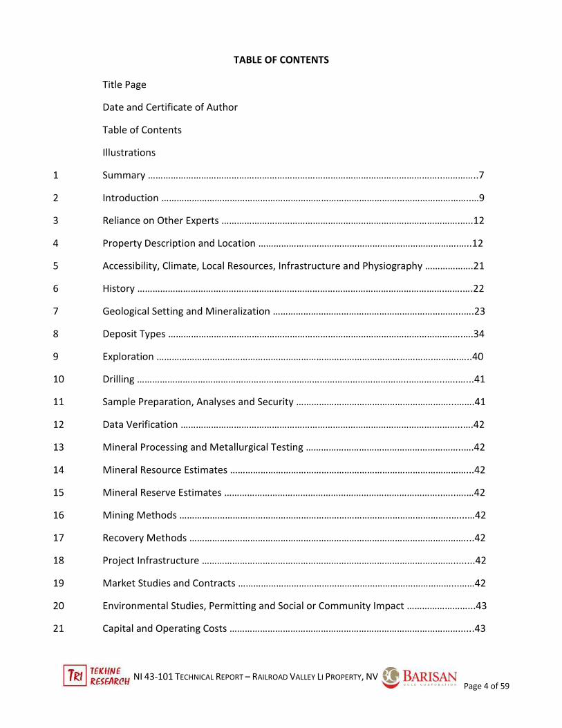
TABLE OF CONTENTS
Title Page
Date and Certificate of Author
Table of Contents
Illustrations
1 Summary ……………………………………………………………………………………………………..…………..7
2 Introduction …………………………………………………………………………………………………………..…9
3 Reliance on Other Experts ………………………………………………………………………………….…..12
4 Property Description and Location …………………………………………………………………….…..12
5 Accessibility, Climate, Local Resources, Infrastructure and Physiography ……………….21
6 History ………………………………………………………………………………………………………….…….….22
7 Geological Setting and Mineralization ………………………………………………………………...….23
8 Deposit Types ………………………………………………………………………………………………….….….34
9 Exploration ……………………………………………………………………………………………….……….…..40
10 Drilling ……………………………………………………………………………………………..…………..…..…...41
11 Sample Preparation, Analyses and Security ……………………………………………………...…….41
12 Data Verification ……………………………………………………………………………………….………..….42
13 Mineral Processing and Metallurgical Testing ……………………………………………………..….42
14 Mineral Resource Estimates …………………………………………………………………………………...42
15 Mineral Reserve Estimates …………………………………………………………………………..…..….…42
16 Mining Methods ……………………………………………………………………………………………..…...…42
17 Recovery Methods ………………………………………………………………………………………………....42
18 Project Infrastructure ………………………………………………………………………………………........42
19 Market Studies and Contracts …………………………………………………………………………...……42
20 Environmental Studies, Permitting and Social or Community Impact ……………………...43
21 Capital and Operating Costs ………………………………………………………………………………......43

NI 43-101 TECHNICAL REPORT – RAILROAD VALLEY LI PROPERTY, NV
Page 5 of 59
22 Economic Analysis …………………………………………………………………………………………..….…43
23 Adjacent Properties ………………………………………………………………………………………..….…43
24 Other Relevant Data and Information ……………………………………………………………..……43
25 Interpretation and Conclusions ……………………………………………………………………..........43
26 Recommendations …………………………………………………………………………………………….….44
27 References ………………………………………………………………………………………………………......48
Appendix A –Detailed claims data…………………………………………………………………......….50
Illustrations
Figure 1 Location of Railroad Valley Property ........................................................................................... .13
Figure 2a Railroad Valley – east entry on Hwy 6 ........................................................................................ 14
Figure 2b RRE claims from Hwy 6……………………………………………………………………………………………………….….14
Figure 3 Claims map: East Block (RRE) Railroad Valley lithium property ................................................... 15
Figure 4a RRE claim block looking east to Troy Peak ................................................................................. 16
Figure 4b RRW claim block facing north from Shell Lockes #1 well………………………………………………………..16
Figure 5 Claims map: West Block (RRW) Railroad Valley lithium property . .............................................. 17
Figure 6a RRW claims southwest of Diversified Oil’s Playa Carmelita #3 well .......................................... 18
Figure 6b..Typical placer claim monuments (RRE)………………………………………………………………………….…….…18
Figure 7a & b Placer claim affidavit examples (RRE & RRW). ................................................................... 19
Figure 8 Regional geology map . ................................................................................................................ 25
Figure 9 Legend for geology map ............................................................................................................... 26
Figure 10 Seismic section W to E across Railroad Valley. .......................................................................... 28
Figure 11 Areal distribution of mature Ro oil source rock beneath Railroad Valley………………………….……30
Figure 12 Age vs. burial depth – Spencer-Federal #32-29, Eagle Springs @2 & Bacon Flat #5 wells ........ 31
Figure 13 Shallow crustal residual (isostatic) gravity beneathe Railroad Valley ........................................ 32
Figure 14 NURESED soil samples in Railroad Valley, Nevada. .................................................................... 34
Figure 15 Areal distribution of young rhyolite volcanics near Railroad Valley, NV………………………………...37
Figure 16 Total catchments basins draining into Railroad and Clayton Valleys, NV ……………………….……...40

NI 43-101 TECHNICAL REPORT – RAILROAD VALLEY LI PROPERTY, NV
Page 6 of 59
Figure 17 Map of Oil-Gas-Water wells through 2013 in Railroad Valley……………………………………….…….….45
Figure 18 RRW proposed MT geophysical lines, Phase 1 program…………………………………………...……......…46
Figure 19 RRE proposed MT geophysical and soil geochemical (150-m stations) lines……………………….….47
Tables
Table1 Units & Abbreviations..................................................................................................................... 11
Table 2 Plant communities & evapotranspiration in Railroad Valley.. ...................................................... 21
Table 3 Stratigraphic Column ..................................................................................................................... 24
Table 4 Basin fill stratigraphy. .................................................................................................................... 27
Table 5 Comparison between Clayton Valley and Railroad Valley. ............................................................ 39

NI 43-101 TECHNICAL REPORT – RAILROAD VALLEY LI PROPERTY, NV
Page 7 of 59
1 SUMMARY
The Railroad Valley Project is has two claim blocks in the large extensional Railroad Valley basin with no
exploration for lithium brines. It is located in the northeastern corner of Nye County, Nevada in east central
Nevada which has largest oil field in Nevada.
On 18 July 2016, Barisan Gold Corporation (TSXV-BG) (the "Issuer”) announced that it has entered into an
agreement with DG Resource Management ("DGRM") and Arizona Lithium Company Limited (“ALCL”) dated
July 15, 2016, as amended (the "Agreement") to acquire 100% interest in the Railroad Valley Lithium Property
located in Nevada, USA and the Black Canyon Lithium Property located in Arizona, USA.
Under the terms of the Agreement, and subject to the approval of the TSX Venture Exchange, the Company
will pay an aggregate of CDN$100,000 in cash, US$33,341, and issue common shares representing up to
19.99% of the issued and outstanding of the Issuer (pre-consolidated) to DGRM in exchange for a 100% equity
interest in each the Railroad Valley Lithium Property located in Nevada, USA and the Black Canyon Lithium
property located in Arizona, USA. The US$33,341 cash payment shall be provided to DGRM from the Issuer in
order to pay for annual claim filing fees regarding the mineral tenures of each property. The shares being
received together with any shares in the Issuer held by each DGRM and ALCL or any other director or officer or
other insiders of each DGRM and ALCL shall not exceed 19.99% of the issued and outstanding shares of the
Issuer. DGRM will also retain a 2% Net Smelter Royalty on each property.
The registered owner of the claims of each property is ALCL, which is closely affiliated with DGRM by common
management and shareholders. The relationship was reviewed by the author, based on corporate filings from
Alberta and Nevada.
This report describes the Railroad Valley Property only.
The Railroad Valley Property possesses these significant features related to lithium brine deposits:
• Located in the large Railroad Valley, a closed, arid basin, with a highly evapotranspirative hydrologic
environment;
• Basin infill sediments have been drilled and tested by oil exploration since 1954 with infill depths from 150
to 2,900 m as an asymmetrical graben with a fault-bounded, deep, restricted basin;
• Extensive oil exploration and development has generated a large data set on characteristics of basin
stratigraphy, depth to bedrock, and fault accessible for analysis;
• The property shares many geological and physiological characteristics with the well-known Clayton Valley
basin, Nevada’s sole producer of lithium brine since 1966; and
• The property has never been explored for lithium brine potential.
The Railroad Valley Property has two non-contiguous claim blocks located in the central part of the Railroad
Valley. The Railroad Valley-East (RRE) block includes section 5 of Twp. 8N, Rng. 57E and sections 20, 23, 29, and
32 of Twp.9N, Rng.57E, and comprises 100 placer claims (2000 acres/809 ha). The Railroad Valley –West (RRW)
claim block lies 3.2 kilometres west and includes sections 4 and 5 of Twp. 8N, Rng. 56E and sections 26-228
and 33-353 of Twp.9N, Rng.56E on Meridian 21 Mt. Diablo Range and Baseline and comprise 99 placer claims
(1980 acres/802 ha) in northeastern Nye County, Nevada. The mineral rights apply to surface and subsurface
minerals in unconsolidated sediments and rocks. The land is administered by the US Bureau of Land
Management (BLM). The anniversary date for all mineral claims is 1 September when annual fees and work
report filings, if applicable. ALCL filed the annual maintenance fees with BLM and the Notice of Intent to Hold

NI 43-101 TECHNICAL REPORT – RAILROAD VALLEY LI PROPERTY, NV
Page 8 of 59
with Nye County through 31 August 2017. The claims are in good standing until then.
The property is accessible from Ely, NV by traveling 48 miles (77 km) southwest on US Highway 6 toward
Tonopah. Hwy 6 passes within one to three miles (1.6 – 5 km) across the north ends of both claim blocks. Good
quality gravel roads constructed for oil extraction provide access to the blocks; these also provide access to the
northern two of the four Railroad Valley Wildlife Management Areas (RVWMA).
The Railroad Valley Property is situated In the Great Basin physiographic province of the Basin and Range
tectonic province. North-south trending mountain ranges and intermontane basins often with playas (alkali
flats) characterize the area. Elevations in the Railroad Valley playa range from 4,725 to 4,760 ft (1,440-1,450
m); the highstand shoreline of the southeast side of Railroad Valley Lake at Heath Canyon is 4,860 ft (1,484 m).
The rugged Grant and Quinn Ranges forms the eastern margin of the valley and rises to 10,945 ft ASL (3,336 m)
at Troy Peak, while the undulant Pancake Range west of the valley reaches 6,260 ft ASL (1,908 m) on Hwy 6.
Historically, no exploration work or samples from oil field water analyses were tested for lithium brine
potential. Neither the Optionor nor the Issuer has undertaken any exploration work since the location of the
placer claims in April 2016. Information derived from oil exploration and development permits interpretations
of volume and geological details of the basin fill and its context with warm oil-producing bedrock.
The oldest rocks occur in the ranges flanking the Railroad Valley. The lithologies date from Cambrian as back-
arc sedimentary rocks that persisted through the late Devonian period with the onset of the Antler Orogeny to
the west. The period from the late Devonian through Mississippian (middle Paleozoic) saw development of a
carbonate-dominant platform sequence In Mississippian time, the area was covered by shaley limestone
platform sediments associated with the distal portions of a foreland basin developed to the east of the Antler
orogenic highland. Pennsylvanian and Permian strata in this area reflect carbonate sedimentation in restricted
to open lagoon settings, with some clastic input from the east. These formations are the source and
sometimes the reservoir rocks for oil in Railroad Valley oil fields. A series of contractional orogenic events
affected the eastern Great Basin during the Mesozoic, including the Jurassic Elko orogeny, manifested by low-
grade metamorphism and the intrusion of the Troy Peak granite, and the Cretaceous Sevier orogeny, marked
by thin-skinned, east- to southeast-directed folding and thrusting. Tertiary volcanics unconformably covered
the older stratigraphy. The entire Great Basin has been affected by extension and uplift of the ranges, starting
in late Eocene time and continuing to the present. The uplift led to the formation of low-angle attenuation
normal faults on the Grant and Quinn Ranges east of the Valley between ~20 and ~2.6 Ma; these dip west into
the basin. The moderate-angle graben faults dip west and post-date the attenuation faults (Camilleri, 2013).
The most obvious manifestation of this extension is the pattern of north- to northeast-trending mountain
ranges and intervening basins in this area, which gives the Basin and Range Province its name.
Pancake Range on the western side is covered mainly by Oligocene to Miocene felsic volcanics that
unconformably overlie the Paleozoic stratigraphy with the same history as the ranges east of the basin. The
basin formed as a half-graben with the east side down-faulted while the western margin abutting the Pancake
Range showed only minor local faulting of young (< 2.6 Ma age) low-angle beds and volcanic flows.
Transpressional movement along the east side of the graben with the west side to the north opened a deep
basin sector with depths to bedrock about 2,900 m during the beginning of the basin infilling. Likely the
depression continued growth during deposition of the older basin fill member, but the basin fill stratigraphy is
not consistently documented in oil well logs. Pluvial and alluvial sediments and young rhyolite and basalt
volcanic flows and volcaniclastics continued filling the basin with the younger basin fill member. During drier
periods, minor evaporites were deposited (Denburgh and Rush, 1974), but the extent of these beds is
unknown.

NI 43-101 TECHNICAL REPORT – RAILROAD VALLEY LI PROPERTY, NV
Page 9 of 59
Oil well logs indicate the presence of tuffs and clay lacustrine layers among coarser sediments and
volcaniclastics. Burial and geothermal water diagenesis changed at least some of the sediments to more clay-
rich equivalents, but the logs are not consistent in reporting, since the oil geologists were not interested in
basin fill as a target.
Railroad Valley is a green-fields lithium target believed to be an analogue to Clayton Valley, about 200 km to
the west-southwest. Both are typical arid, closed basins with no water outflow and a common stratigraphic
history of pluvial and arid climate variations. Railroad Valley hosts a larger playa, larger catchment area, and
deeper basin fill than Clayton Valley. Similar graben fault structures active into Holocene time occur in both
settings, which suggest the potential for tectonic isolation of potential brine aquifers to retain brines. Surface
reconnaissance soil sampling returned samples up to 275 ppm Li, but no brine has been located on the
property. Similar values occur in the brine at the Albemarle Silver Peak lithium mine.
In conclusion, with many features similar to Clayton Valley and with no exploration work targeting lithium to
date, Railroad Valley represents a new and untested target for lithium brine. The Railroad Valley brine
exploration can build on both the dense existing oil field data and the experiences at Clayton Valley and other
Li-brine basins to target potential brine aquifers.
The recommended work program consists of two phases. Phase 1 will focus on collecting and synthesizing
available data from oil exploration together with Magnetotelluric (MT) electromagnetic surveys along four
lines totaling 16 km on the two claim blocks to test for saline conductors, faults, and basin depth. A systematic
soil geochemical program is recommended to test Li anomalies in historical regional data below surface wind-
blown contamination/dilutants. The analytical technique would mimic the natural alkaline brine setting of ionic
Li so that the soluble Li was being measured. The three aspects can be done concurrently for US$ 88,500,
excluding taxes.
Assuming the results of Phase 1 are encouraging, Phase 2 would follow with the selection of three drill sites on
Railroad Valley West and one or two on Railroad Valley East for a total of 1,450 m for US$ 280,000.
2 INTRODUCTION
2.1 Issuer
The Issuer of this report is Barisan Gold Corp. which is based in Vancouver, BC, Canada and trading on the TSX-
Venture Exchange under the symbol BG.
2.2 Term of Reference
Barisan Gold Corp. (“Barisan” or the “Issuer”) engaged the services of the author through Tekhne Research Inc.
of Victoria, BC on 28 July 2016 to write an independent NI 43-101 Technical Report on the Railroad Valley
Lithium Property in Nye Co. near Ely, Nevada as part of its qualifying documentation for the TSX Venture
Exchange.
2.3 Sources of Information
The Railroad Valley Property has had no known historical or current mineral exploration. DG Resource
Management (“DGRM” or “Optionor”) contracted the claim acquisition in April 2016. The primary sources of
claims information used in this report was the BLM mining claims geographical report reviewed on 15 August
2016 that includes claims registered as recently as 90 days from the search date. This forms Appendix A. Claims
located after 17 May 2016 may be present but are yet recorded.
NI 43-101 TECHNICAL REPORT – RAILROAD VALLEY LI PROPERTY, NV
Page 10 of 59
The author reviewed documents made available to Barisan and the author In July and August as well as
independent data research by the author. The historical and scientific sources are publications listed under
References herein. They include regional geochemical and gravity surveys done by the USGS, reports on oil and
gas geology and development in the Railroad Valley including wells under and surrounding the property itself,
and water resource and aquifer systems publications that cover the property area.
The author visited the property and area for one day on 9 August 2016 and visited nearby lithium brine areas
in Clayton Valley, NV on 10 August. Neither the Optionor nor the Issuer had representatives on site since there
was no activity on site at the time of the visit.
2.4 Units and Abbreviations
Units of measurement in this report are quoted in the English system. Assay and analytical results are quoted
in parts per million (ppm). Where historical values are reported, the units are those of the referenced report.
Monetary values are given in US dollars (US$). Other acronyms and abbreviations are listed below in Table 2.1.

NI 43-101 TECHNICAL REPORT – RAILROAD VALLEY LI PROPERTY, NV
Page 11 of 59
Table 1 Units and abbreviations
AA Atomic Absorption Spectrometry analytical technique
acre acre = 0.405 hectares
ASL Above Sea level
B boron
Ba barium
BLM United States Department of the Interior, Bureau of Land Management
Ca calcium
˚C degrees Centigrade
cm centimeter = 0.3937 inch
core diamond drill core
CSAMT Controlled Source Audio Magnetotelluric electromagnetic geophysical survey method
GIS Geographic Information System
GPS Global Positioning System satellite-based navigation system
ha hectare = 2.471 acres
ICP/ES Inductively Coupled Plasma Mass Spectrometry analytical technique at Oak Ridge lab
ICP/MS Inductively Coupled Plasma Mass Spectrometry analytical technique
IP Induced-Polarization geophysical surveying method
K potassium
kg kilogram = 2.205 pounds
km kilometer = 0.6214 mile
Kv kilovolt = 1000 volts
l liter = 1.057 US quart
Li lithium
Ma million years old
µm micron = one millionth of a meter
m meter = 3.2808 feet (1,000 meters = 1 kilometer)
Mg magnesium
mGal Galileo (Gal) a unit of acceleration used in gravimetry. 1 cm/s2.;
milligal (mGal) = 1,000th
of a Gal
GIS Geographic Information System
MT Magnetotelluric electromagnetic geophysical surveying technique
Na sodium
NV Nevada
oz. troy ounce (1 troy ounce = 34.2857 g)
P phosphorus
ppm parts per million (1 ppm = 1 g/t)
ppb parts per billion (1,000 ppb = 1 ppm)
RC Reverse-Circulation drilling method
Rng Range
SEM Scanning Electron Microscope
Sr strontium
t metric ton = 1.1023 short tons
ton short ton (= 2000 lbs or 907.2 kilograms)
Twp Township
USFS United States Forestry Service
USGS United States Geological Survey
VLF Very Low Frequency electromagnetic geophysical survey method
3D three-dimensional

NI 43-101 TECHNICAL REPORT – RAILROAD VALLEY LI PROPERTY, NV
Page 12 of 59
3 RELIANCE ON OTHER EXPERTS
The author relied on data from the US BLM online mining claims geographical report reviewed on 15 August
2016 that includes claims registered as recently as 90 days from the search date, i.e., 17 May 2016.
4 PROPERTY LOCATION AND DESCRIPTION
4.1 Location
The Railroad Valley Lithium Project consists of two blocks of placer claims, Railroad Valley East (RRE) and
Railroad Valley West (RRW) in the north-central lowest part of the Railroad Valley playa (alkali flats) in
northeastern Nye County in east-central Nevada (Figure 1) at approximately 38o 35’10” North Latitude and
115o 39’50” East Longitude. It is located approximately 48 miles (77 km) southwest of Ely, Nevada, the nearest
service community, a few miles southeast of Hwy 6, and 120 miles (193 km) east-northeast of Tonopah,
Nevada.
4.2 Property Description and Ownership
As of 15 August 2016, US Bureau of Land Management (BLM) online records document that the Railroad Valley
Property has two non-contiguous claim blocks located in the central part of the Railroad Valley. The Railroad
Valley-East (RRE) block includes section 5 of Twp. 8N, Rng. 57E and sections 20, 23, 29, and 32 of Twp.9N,
Rng.57E, and comprises 100 placer claims (2000 acres/809 ha). The Railroad Valley –West (RRW) claim block
lies 3.2 kilometres west and includes sections 4 and 5 of Twp. 8N, Rng. 56E and sections 26-228 and 33-353 of
Twp.9N, Rng.56E on Meridian 21 Mt. Diablo Range and Baseline and comprise 99 placer claims (1980
acres/802 ha) in northeastern Nye County, Nevada. The mineral rights apply to surface and subsurface
minerals in unconsolidated sediments and rocks directly beneath the claim boundaries.
Arizona Lithium Co., Ltd., a close affiliate of DG Resource Management by common shareholders and
management, is the sole registered claim owner of both claim blocks. This review by the author was based on
copies of Alberta and Nevada corporate filings provided by DGRM.
The unpatented placer claims are located in the field with wooden nominal 2 inch by 2 inch by 4 foot high
wooden posts with metal tags and location documents affixed on the north boundary of each claim (see
Figures 6b and 7a & b). The location of the claims is made by aliquot, that is, a 1320 ft by 660 ft portion of a
legal land subdivision (section-range-township) that meets Nevada regulations. The online review of US BLM
data of the Railroad Valley unpatented placer claims listed in Appendix A is complete and accurate as of 17
May 2016, and that all claims are valid through 31 August 2016, the common date for payment of annual fees
and any technical report filings. No legal surveys of the placer claims have been made on the property.
Ownership of unpatented mining claims is in the name of the holder (locator), subject to the paramount title
of the United States of America, under the administration of the U.S. Bureau of Land Management (BLM).
Under the Mining Law of 1872, which governs the location of unpatented mining claims on Federal lands, the
locator has the right to explore, develop, and mine minerals on unpatented mining claims without payments of
production royalties to the U.S. government, subject to the surface management regulation of the BLM.
Mineral rights for unpatented placer claims include surface and subsurface minerals in unconsolidated, non-
lode sediments and rocks. Surface rights can be applied for through the BLM. New claims have a 90 day period
from the staking date to be registered with BLM and the county. Nevada BLM records of mining claims can be
searched on-line at www.nv.blm.gov/lr2000/.
Annual holding costs are US$ 155.00/claim to the US BLM and $12.00/claim plus a single $4.00 filing fee to

NI 43-101 TECHNICAL REPORT – RAILROAD VALLEY LI PROPERTY, NV
Page 13 of 59
Nevada paid at the county seat, in the case of Nye County, Tonopah. Annual holding costs for 2017 will total
$33,137. The anniversary date for all mineral claims is 1 September when annual fees and work report filings, if
applicable. ALCL filed the annual maintenance fees with BLM and the Notice of Intent to Hold with Nye County
through 31 August 2017. The claims are in good standing until then.
Fig. 1 Location of Railroad Valley, Nevada
(after Nevada Water Basin database Aug 2016 and author)

NI 43-101 TECHNICAL REPORT – RAILROAD VALLEY LI PROPERTY, NV
Page 14 of 59
Figure 2a Railroad Valley, NV east entry on Hwy 6 facing SW
Figure 2b RRE Claims from Hwy 6, looking SSE
GRANT RANGE QUINN RANGE
RRE Claim Block

NI 43-101 TECHNICAL REPORT – RAILROAD VALLEY LI PROPERTY, NV
Page 15 of 59
Figure 3 Claims Map: East Block, Railroad Valley Lithium Property
(after Carlin Trends Mineral Services Inc. Apr 2016 and author)
SPENCER-FEDERAL #32-29

NI 43-101 TECHNICAL REPORT – RAILROAD VALLEY LI PROPERTY, NV
Page 16 of 59
Figure 4a RRE Claim Block looking east to Troy Peak
Figure 4b RRW Claim Block, looking N from
Shell Lockes #1 well in RVWMA
Shell Lockes #1 is on seismic profile
RRE Claim Block
GRANT RANGE
PANCAKE RANGE

NI 43-101 TECHNICAL REPORT – RAILROAD VALLEY LI PROPERTY, NV
Page 17 of 59
Figure 5 Claims Map: West Block, Railroad Valley Lithium Property
(after Carlin Trends Mineral Services Inc. Apr 2016 and author)
SHELL LOCKES #1
Diversified PC #3

NI 43-101 TECHNICAL REPORT – RAILROAD VALLEY LI PROPERTY, NV
Page 18 of 59
Fig. 6a RRW Claims southwest from Diversified Oil Playa Carmelita #3 well
Fig. 6b Typical Placer Claim Monuments
with Affidavit Vials (RRE)
RRW CLAIM BLOCK – SW SECTION

NI 43-101 TECHNICAL REPORT – RAILROAD VALLEY LI PROPERTY, NV
Page 19 of 59
Figure 7a Placer claim affidavit - RRE #1 claim
Figure 7b Placer claim affidavit - RRW #59 claim
(after Carlin Trends Mineral Services Inc. and author)

NI 43-101 TECHNICAL REPORT – RAILROAD VALLEY LI PROPERTY, NV
Page 20 of 59
4.3 Issuer’s Interest
On 18 July 2016, Barisan Gold Corporation (TSXV-BG) (the "Issuer”) announced that it has entered into an
agreement with DG Resource Management ("DGRM") and Arizona Lithium Company Limited (“ALCL”) dated
July 15, 2016, as amended (the "Agreement") to acquire 100% interest in the Railroad Valley Lithium Property
located in Nevada, USA and the Black Canyon Lithium Property located in Arizona, USA.
Under the terms of the Agreement, and subject to the approval of the TSX Venture Exchange, the Company
will pay an aggregate of CDN$100,000 in cash, US$33,341, and issue common shares representing up to
19.99% of the issued and outstanding of the Issuer (pre-consolidated) to DGRM in exchange for a 100% equity
interest in each the Railroad Valley Lithium Property located in Nevada, USA and the Black Canyon Lithium
property located in Arizona, USA. The US$33,341 cash payment shall be provided to DGRM from the Issuer in
order to pay for annual claim filing fees regarding the mineral tenures of each property. The shares being
received together with any shares in the Issuer held by each DGRM and ALCL or any other director or officer or
other insiders of each DGRM and ALCL shall not exceed 19.99% of the issued and outstanding shares of the
Issuer. DGRM will also retain a 2% Net Smelter Royalty on each property.
The registered owner of the claims of each property is ALCL, which is closely affiliated with DGRM as reported
to the Issuer’s counsel by DGRM’s counsel. This was not independently reviewed by the Issuer or the author.
This report describes the Railroad Valley Property only.
4.4 Environmental Liabilities
No known environmental liabilities exist on the two claim blocks. The author visited the old and active oil well
sites on and near the properties on the site visit, and they appear to be clean and tidy. Old well sites have been
reclaimed.
4.5 Permitting
No permits are in place or are under application. The BLM administers the permits for this area. Since part of
each claim block is abuts units of the Railroad Valley Wildlife Management Area (RVWMA), which is
administered by BLM, any proposed exploration program will need to be reviewed with BLM. The BLM District
Office in Battle Mountain, NV has jurisdiction over the RVWMA.
4.6 Social or Community Impacts
No towns or settlements lie within 20 miles of the project area. Working ranches operate within six miles (10
km) of the claims and oil production and rights occur on the two claim blocks, especially RRW. The property
lies on BLM lands.
There are no known aboriginal issues on the property area.
4.7 Other Risks
Since the Railroad Valley Project lies on Federal land, there are low to moderate risks associated with
executing the program recommended in this report. Potential impacts on several parcels of the RVWMA need
attention.
Access to water is a potential risk. Water likely can be purchased from ranchers within six miles (10 km) of the
project area where springs mark the margins of the basin.

NI 43-101 TECHNICAL REPORT – RAILROAD VALLEY LI PROPERTY, NV
Page 21 of 59
No environmental, social, or community risks are foreseen.
5 ACCESSIBILITY, CLIMATE, LOCAL RESOURCES, INFRASTRUCTURE, AND PHYSIOGRAPHY
5.1 Accessibility
The property is accessible from Ely, NV by traveling 48 miles (77 km) SW on US Highway 6 toward Tonopah.
Hwy 6 passes within one to three miles (1.6 – 5 km) across the north ends of both claim blocks. Several gravel
roads constructed for oil extraction provide access to the blocks; these also provide access to the northern two
of the four Railroad Valley Wild Life Refuge areas.
5.2 Climate and Vegetation
The climate in the project area is typical of lower basinal/playa elevations of the eastern Great Basin;
January temperatures average about 32o F (0° C), with a range of approximately -30o to 40o F (-35° to 5° C).
July temperatures average approximately 65o F (18 C), with a range from 40o to 90o F° (50° to 35°C). Humidity
and precipitation are low. Precipitation ranges from less than 10 inches (~25 cm) per year on the valley floors
to as much as 32 inches (80 cm) per year in the mountains with most of the precipitation falling in the
December-March period (Van Denburgh and Rush, 1974). Exploration drilling can normally be carried out year-
round in the basins, but the soils can be wetter in winter and present some access issues.
P inion, juniper, and mountain mahogany are found in higher elevation areas in the ranges flanking the basin.
On the playa, subtle differences in soils lead to specialized plant communities. Table 1 shows the proportion of
plant communities in Railroad Valley from driest playa to wetlands together with the effect on
evapotranspiration. The driest two communities show a low rate of transpiration, as expected for more
extreme conditions, while the higher two account for ¾ of the water evaporated. The transpiration rates
increase by the square (power 2).
Plant Zone Evapotranspiration per year
area (mi2) % of RRV rate (ft/yr) acre-ft/yr m3/yr %
Playa 59.4 17% 0.1 3,800 4,674,000 5%
Phreatophyte 106.2 30% 0.2 14,000 17,220,000 17%
Saltgrass 172 48% 0.4 44,000 54,120,000 54%
Wetlands 19.4 5% 1.6 19,600 24,108,000 24%
Total area 357 100% 81,400 100,122,000 100%
meadow grass , tules ,
wet-area phreatophytes ;
minor open water
surface
Vegetation Area
bare soi l , minor
sa ltbush
greasewood,
rabbitbrush, sa l tbrush
w/ or w/out
phreatophytes
Table 2. Plant communities & evapotranspiration in northern Railroad Valley, NV
(after Van Denburgh and Rush, 1974)
5.3 Local Resources and Infrastructure
The nearest town is the town of Ely, located approximately 77 km to the east-northeast. Heavy equipment and
operators are available in Ely, as well as food and accommodation. Most services, including drilling and mining
contractors, are available 200 km to the north in Elko, the regional centre. There are limited technical services

NI 43-101 TECHNICAL REPORT – RAILROAD VALLEY LI PROPERTY, NV
Page 22 of 59
in Tonopah, the Nye County seat, as well as BLM, USFS, and county administration services.
There is no power or other facilities, except road access, on the property. Several petroleum companies have
active wells and refineries on or adjacent to the claim blocks that use power brought in on private lines.
Drilling water could be purchased from ranchers within six miles (10 km) of the properties.
The amount of surface land needed for a lithium brine operation depends on the volume of brines treated and
how spent brines are disposed (by evaporation or pumping back into the aquifers from which they originated.
There appears to be a sufficiently large area not obviously being utilized by ranching or active petroleum
extraction to support an evaporation basin complex similar to the Silver Peak Lithium Mine in Clayton Valley,
Nevada. The actual separation plant infrastructure occupies a few acres (~1 ha) or less. A critical issue will be
fresh water demand, which will need consideration depending on the potential size of any deposits located on
the property.
5.4 Physiography
The Railroad Valley Property is situated In the Great Basin physiographic province of the Basin and Range
tectonic province. North-south trending mountain ranges and intermontane basins often with playas (alkali
flats) characterize the area. Elevations in the Railroad Valley playa range from 4,725 to 4,760 ft (1,440-1,450
m); the highstand shoreline of the southeast side of Railroad Valley Lake at Heath Canyon is 4,860 ft (1,484 m).
The rugged Grant and Quinn Ranges forms the eastern margin of the valley and rises to 10,945 ft ASL (3,336 m)
at Troy Peak, while the undulant Pancake Range west of the valley reaches 6,260 ft ASL (1,908 m) on Hwy 6.
6 HISTORY
Barisan and DGRM report that no NI 43-101-compliant Technical Report has been issued on the Railroad Valley
Property to date. DGRM acquired the claims in 22-24 April 2016 and has done no technical work itself on the
property.
No work specifically targeting minerals exploration or development, either as lode (bedrock) or placer
(unconsolidated) deposits has been done on the property. There is no evidence of prior placer claim ownership
related to lithium exploration in the central Railroad Valley. The Railroad Valley bedrock beneath the basin fill
has produced about 90% of Nevada’s oil since 1954 (Anna, et al., 2005) from five fields in the valley. The
results from seismic surveys and drilling have yielded a greater amount of detail in 3D than exists in other
potential Li-brine valleys. A number of papers provide perspectives based on seismic surveys, drill logging, and
field geology of the basin-bounding geology. These have provided information and insights into the potential
of Railroad Valley and are discussed in Section 7.
Regional geophysical and geochemical surveys by government agencies since 1979 include the basin area, with
soil sediment, groundwater, and surface gravity surveys.
Regional sampling for uranium, among other geochemically related elements, including lithium, was
conducted by various US government agencies between 1973 and 1986 under the National Uranium Resource
Evaluation – Hydro geochemical and Stream Sediment Reconnaissance (NURE-HSST) program. It was a US-wide
assessment of uranium and secondarily other elements in soils and waters. The program data now is managed
by the US Geological Survey and forms their National Geochemical Survey Database, available at
http://mrdata.usgs.gov/geochem/. In the Railroad Valley area, over 346 surface soil samples were collected in
1980. Anomalous Li values were located on the Railroad Valley West claims as were somewhat lower values on
the East claims as well. The results are discussed in Section 9 and analyses and QA/QC in Section 11.

NI 43-101 TECHNICAL REPORT – RAILROAD VALLEY LI PROPERTY, NV
Page 23 of 59
Water resources of Railroad Valley were appraised by Van Denburgh and Rush (1974) in detail. They had the
advantage of talking with the original oil operators regarding saline waters and deeper drilling. One oil
geologist recorded encountering several layers of crystalline gaylussite, a Na + Ca soluble carbonate, showing
the presence of evaporates in recent time. The seismic data showed that the valley was a fault-bounded,
closed basin with a number of local-scale and often hidden young faults in the basin fill. Evapotranspiration
was documented with a water flow budget.
The USGS, under its Regional Aquifer Study Analysis (RASA) program (Harrill and Prudic, 1998), studied the
aquifers in Nevada and adjacent states. They recorded that Railroad Valley was one of the locales for
evapotranspiration which concentrates salts in groundwater in restricted basins. The high Total Dissolved Salts
(TDS) (> 1000 ppm) in eight well and stream waters within the valley likely resulted from the
evapotranspiration. The primary salt components were Ca, Na, Mg, and HCO3; lithium was not mentioned. The
RASA study incorporated data from Van Denburgh and Rush as well as many other contributors.
Ground-based Bouger gravity surveys of Nevada were systematically made in the period 1972-1985. The data
has been processed several times. The most recent compilation was made by Oppliger (2003) for the Nevada
Bureau of Mines and Geology to be GIS-compatible as well as utilizing newer processing algorithms. The results
for Railroad Valley are discussed in Section 7.
7 GEOLOLOGICAL SETTING & MINERALISATION
7.1 Regional Geological Setting
The Railroad Valley Property is located in the eastern Great Basin within the Basin and Range Province. The
oldest rocks occur in the ranges flanking the Railroad Valley. The lithologies date from Cambrian as back-arc
sedimentary rocks that persisted through the late Devonian period with the onset of the Antler Orogeny to the
west. The period from the late Devonian through Mississippian (Paleozoic) saw development of a carbonate-
dominant platform sequence In Mississippian time, when the area was covered by shaley limestone platform
sediments associated with the distal portions of a foreland basin developed to the east of the Antler orogenic
highland. These formations are the principal source and sometimes the reservoir rocks for oil in Railroad Valley
oil fields Pennsylvanian and Permian strata in this area reflect carbonate sedimentation in restricted to open
lagoon settings, with some clastic input from the east and is not petroliferous.
A series of contractional orogenic events affected the eastern Great Basin during the Mesozoic, including the
Jurassic Elko orogeny, manifested by low-grade metamorphism and the intrusion of the Troy Peak granite, and
the Cretaceous Sevier orogeny, marked by thin-skinned, east- to southeast-directed folding and thrusting.
Tertiary volcanics unconformably covered the older stratigraphy. The entire Great Basin has been affected by
extension and uplift of the ranges, starting in late Eocene time and continuing to the present. The uplift led to
the formation of low-angle attenuation normal faults on the Grant and Quinn Ranges east of the Valley
between 20 and 2.6 Ma; these dip west into the basin. The moderate-angle graben faults dip west and post-
date the attenuation faults (Camilleri, 2013). The most obvious manifestation of this extension is the pattern of
north- to northeast-trending mountain ranges and intervening basins in this area, which gives the Basin and
Range Province its name.
Pancake Range on the western side is covered mainly by Oligocene to Miocene felsic volcanics that
unconformably overlie the Paleozoic stratigraphy with the same history as the ranges east of the basin. The
basin formed as a half-graben with the east side down-faulted while the western margin abutting the Pancake
Range showed only minor local faulting of young (< 2.6 Ma age) low-angle beds and volcanic flows.
Transpressional movement along the east side of the graben opened a deep basin sector with depths to

NI 43-101 TECHNICAL REPORT – RAILROAD VALLEY LI PROPERTY, NV
Page 24 of 59
bedrock about 2,900 m during the beginning of the basin infilling. Likely the depression grew during deposition
of the older basin fill member, but the basin fill stratigraphy is not consistently documented in oil well logs.
Pluvial and alluvial sediments and young rhyolite and basalt volcanic flows and volcaniclastics continued filling
the basin with the younger basin fill member. During drier periods, minor evaporites were deposited
(Denburgh and Rush, 1974), but the extent is unknown. The transpressional faulting may account for
differences in the apparent depths of bedrock burial between the Grant and Quinn Ranges to the east, where
the Quinn Range shows more exhumed metamorphic rock. The Heath Canyon Valley divides the two ranges.
Drill log data from several oil wells on and adjacent to the properties, as well as mapping on the adjacent
ranges, i.e., Camilleri, 2013, shows the sequence from youngest to oldest:
Table 3 Stratigraphic Column
Tertiary Pliocene to present Younger basin fill – unconsolidated clastic sediments, fanglomerate to
claystone, minor evaporite beds, minor younger rhyolite flows and clastics;
permeable; best aquifers
unconformity
Tertiary mid-Miocene to mid-Pliocene Older basin fill sediments: volcanic flows and clastics with
lacustrine interbeds
unconformity
Tertiary upper Eocene Indian Well Fm – coeval with Garrett Ranch: tuff, ash, agglomerate,
tuff-lacustrine sediments; coeval with Garrett Ranch Fm.
Tertiary upper Eocene Garrett Ranch Fm – felsic ignimbrite (local unit @ RRV); produces oil
unconformity
Tertiary upper Paleocene Sheep Pass Fm – fluvio-lacustrine clastics and basal breccias
unconformity
Permian Pequop Fm – shale, siltstone, limestone
Pennsylvanian Ely and Bird Springs Fms -- limestone
unconformity
Mississippian Chainman Fm – carbonate and shaley carbonate rocks that host the oil
Older metamorphosed Cambro-Devonian sedimentary rocks and several granitic intrusions lie beneath the
Mississippian and younger formations, but were not encountered in the deepest oil drilling beneath the valley.
Details of the basin fill stratigraphy and structure are discussed in the Property Geology (Section 7.1) below.

NI 43-101 TECHNICAL REPORT – RAILROAD VALLEY LI PROPERTY, NV
Page 25 of 59
Figure. 8 Regional Geology, Railroad Valley, Nevada (after Crafford, 2007)
(Geology legend on Figure. 9)
N

NI 43-101 TECHNICAL REPORT – RAILROAD VALLEY LI PROPERTY, NV
Page 26 of 59
Figure 9 Geology Legend for Figure 8 (Crafford, 2007)

NI 43-101 TECHNICAL REPORT – RAILROAD VALLEY LI PROPERTY, NV
Page 27 of 59
7.2 Property Geology
7.2.1 Stratigraphy
The two claim blocks lie on the Railroad Valley playa. The post-Paleozoic basin fill sequence from youngest to
oldest is:
Table 4 – Basin fill Stratigraphy
Tertiary Pliocene to present Younger basin fill – unconsolidated clastic sediments, fanglomerate to
claystone, sorted to chaotic, minor evaporite beds, minor younger rhyolite
flows and clastics; permeable; best aquifers
unconformity
Tertiary mid-Miocene to mid-Pliocene Older basin fill sediments: volcanic flows and clastics with
lacustrine interbeds
unconformity
Tertiary upper Eocene Indian Well Fm – coeval with Garrett Ranch: tuff, ash, agglomerate,
tuff-lacustrine sediments
Tertiary upper Eocene Garrett Ranch Fm – felsic ignimbrite (local unit @ RRV); produces oil
unconformity
Tertiary upper Paleocene Sheep Pass Fm – fluvio-lacustrine clastics and basal breccias
Basin fill units are frequently grouped as one unit, but Plume (1996) observed that many Great Basin valleys
show two events related to the formation of the modern basins. The older member contains bimodal rhyolite
and basalt volcanic flows and derived volcaniclastics interlayered with well-bedded tuffaceous lacustrine
sediments. Permeability in the volcanic flows is low and they trap oil in underlying lacustrine bed, i.e., Trap
Springs oil field at Railroad Valley. This unit may have served to seal the older oil-bearing carbonate bedrock
from hydrocarbon leakage to the surface. Anna et al. (2005) describe several thousand metres of erosion of
the volcanics and lacustrine sediments before the onset of the younger unconsolidated basin fill.
The younger basin fill member is a mixture of epiclastic sediments (gravel, fanglomerate, sand, and clay
ranging from chaotic to well-sorted) interlayered with young rhyolite flows and tuffs from the Pancake Range.
A thin high-carbonate evaporite was recorded in one well (Van Denburgh and Rush, 1974). The depth to
Eocene volcanics ranges from < 500 to 2900 m in the basin. Railroad Valley East claims were located over the
deeper area near the east graben fault.
The older member was deposited before the present basin and range extension started. Plume (1996) suggests
that pre- basin deposition filled other ancient and now-eroded basins. The unit forms old pediments that lie
above the younger sediments on the slopes of flanking ranges. The erosion of the Early Tertiary formations
observed by the oil geologists probably occurred before the modern basins commence forming when the older
fill member would be down-warped (along the western graben margin at Railroad Valley) or faulted into the
emerging basin. The two member division of the basin fill formation appears to be common through much of
the Great Basin region (Plume, 1996) and signifies a subtle but key element in the evolution of the modern
basins.

NI 43-101 TECHNICAL REPORT – RAILROAD VALLEY LI PROPERTY, NV
Page 28 of 59
7.2.2 Structure
The structure of the basin is an asymmetrical basin with the east side the deeper. Figure 10 shows the seismic
profile west to east across Railroad Valley (Vreeland and Berrong, 1979). Typically, the vertical scale is
exaggerated in order to see the details of the strata. The figure shows both the section with the original 1:8.5
vertical scale and the same image at 1:1 vertical scale. The east range-front graben fault is shown steeper than
modern reconstructions (Camilleri, 2013). Line A-A’ passes across the southern tier of RRW and the southern
end of RRE claims to the Eagle Springs on the eastern graben margin. The several western faults coincide
closely with lineaments marked by springs and topography discussed below on RRW. Interpretation by the
author on Figure 11 suggests that the graben had a sinistral transpressional movement (west side moving
north) that opened the graben to greater depths to the basin.
CLAIMS on PROFILE
. RRW . RRE
Original (1:8.5 vertical expansion)
No vertical expansion (1:1)
Figure 10 Seismic Section W-E across Railroad Valley (after Vreeland and Berrong, 1979)

NI 43-101 TECHNICAL REPORT – RAILROAD VALLEY LI PROPERTY, NV
Page 29 of 59
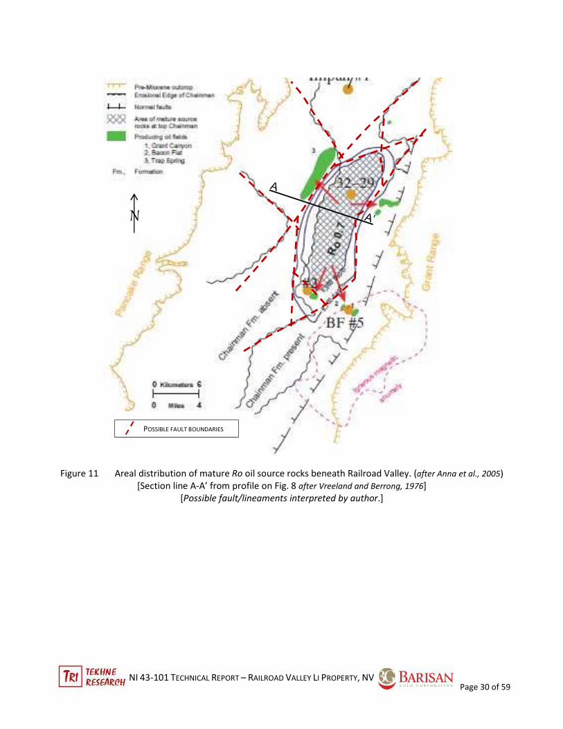
Anna, et al (2005) reviewed the oil field data from Railroad Valley as part of a regional assessment of
undiscovered petroleum in the eastern Great Basin. Three wells in Figure 11 were drilled around the
petroleum core of the basin beneath the playa permitted construction of the burial depth and Ro, the
maturation index of the basement units of the basin from 40 Ma to present. These show the depths of
formations at three well locations over time. The plan map (Figure 7) shows the areal distribution of mature Ro
values 0.7 beneath the playa with the referred well locations. Comparison between the Shallow Crustal
Isostatic Gravity (Figure 13) and Figure 11) shows that the gravity low coincides with the area of Ro > 0.7. This
may be a compounded effect of deeper basin fill plus the increased porosity of the underlying Chainman Fm
source rocks.
The mature oil migrates up or beyond the source limits of Ro; its ultimate reservoir location depends on local
characteristics of traps. The shallowing of the burial in three wells shown in Figure 12 shows the period of
erosion in the Miocene (~23 – ~13 Ma) before the time when the basin formation was developing into its
present configuration. The deepening of the basin between 13 Ma and ~2.6 Ma was the period of oil
emplacement, including movement into the lacustrine-volcanic trap field of Trap Springs.
These data place temporal constraints on the time of deep basin water circulation which may have promoted
diagenesis of volcanic and epiclastic basin fill rocks. The Spencer-Federal #32-29 well (see Figure 11), which
shows the highest heat values closer to surface, also has the deepest basin fill (2,985 m) and the warmest in-
hole temperature at the shallowest depth. It lies on the north boundary of Big Ponds wildlife management
area, possibly on the RRW claims. The RRW claim block lies over and to the north and west of the
northwestern limit of the Ro > 0.7 boundary and overlies part of the Trap Springs oil field. The same well
showed some oil flow east to the Eagle Springs field, passing beneath the RRE claims. The late age of oil
maturation reflects the level of heating to 100°C, the temperature at which oil is formed from petroleum
precursors. It also shows that high heat flux derived from deep groundwater circulation would have interacted
with the deeper basinal fill sediments (Anna, et al., 2005).
Ground gravity survey compilation, reprocessed by Oppliger, 2003, showed the shallow crustal residual
(isostatic) gravity anomalies that includes the Railroad Valley basin. The anomalies are calculated by removing
broad regional anomaly patterns without regard to source. It emphasizes density changes in the upper few
kilometres of the crust and shows patterns. Figure 13 shows a deep low anomaly caused by lower density
material to depth in the Railroad Valley with the intensity scale. Due to the mathematics used, boundaries are
not sharply defined, but can be rapid gradients.
NI 43-101 TECHNICAL REPORT – RAILROAD VALLEY LI PROPERTY, NV
Page 30 of 59
Figure 11 Areal distribution of mature Ro oil source rocks beneath Railroad Valley. (after Anna et al., 2005)
[Section line A-A’ from profile on Fig. 8 after Vreeland and Berrong, 1976]
[Possible fault/lineaments interpreted by author.]
POSSIBLE FAULT BOUNDARIES
N

NI 43-101 TECHNICAL REPORT – RAILROAD VALLEY LI PROPERTY, NV
Page 31 of 59
.
l----------- Old Basin Fill Member ---------------l-Young Basin Fill Member -l
l**** deposition ****l ~~~~ erosion ~~~~ l ****** deposition ****** l
Figure 12 a Age vs. Burial Depth – Spencer-Federal #32-29 well (3740 m max depth)
[Note: expanded time scale differs from Figs 8b and 8c]
Figure 12 b Age vs. Burial Depth – Eagle Springs #2 well (3104 m max depth)
Figure 12 c Age vs. Burial Depth – Bacon Flat #5 well (2225 m max depth)
(all after Anna et al. 2005)
Figure 12 Age vs. burial depth: 3 oil wells in Railroad Valley showing late age erosion of
lower basin fill member

NI 43-101 TECHNICAL REPORT – RAILROAD VALLEY LI PROPERTY, NV
Page 32 of 59
Figure 13 Shallow crustal residual (isostatic) gravity beneath Railroad Valley (gravity after Oppliger, 2003;
Section A-A’ after Vreeland and Berrong,1979; and lineament interpretations by author]
The topography of the area through the western part of RRW claims and to the southwest shows several
lineaments defined by a number of springs. The longest defines a northeast trend that run from springs inside
the south limit of the claims southwest of Lockes Pond for 8.9 km and extends northeast as a topographic
lineament from the last NE spring through the RRW claims and beyond toward Hwy 6 for another 4.8 km for
13.7 km minimum length. A shorter northwest trending lineament perpendicular and cross-cutting the first
one is defined by springs just south of RRW and runs for 3.3 km NW. It may extend SE along the northern limit
of the sandy playa for another 9.1 km towards the Bacon Flat area on the east side of the graben. A north-
trending lineament defined by a ridge of sediment and subtle topography passes 50 m west of the western
Lineament, dot=down
(traced by springs)

NI 43-101 TECHNICAL REPORT – RAILROAD VALLEY LI PROPERTY, NV
Page 33 of 59
portion of the RRW claim block. These are marked on the gravity map, Figure 13, with possible lineament
extensions. These show some coincidence and could reflect the western and southwestern margins of Ro heat
anomaly in Figure 11. The seismic profile in Figure 10 shows several normal faults west of Shell Lockes #1 well
that coincide with two NE-trending lineaments as well.
The pattern of Chainman Fm source rocks in Figure 11 suggests that the possible reticulate fault pattern may
control the presence of the formation. This depends on the data points that Anna, et al. (2005) used; if
exploration wells are more than several miles apart, the alignment of the boundaries of the Chainman can
have a range of azimuths. The author interpreted faults/lineaments on Figure 11.
The rapid change In gravity depth, as suggested by the colour gradients, may reflect significant vertical fault
displacement especially along the north and northeast trending lineaments. The northwest cross-cutting
structure may reflect a younger event. In Clayton Valley, a similar fault pattern defines brine cells. Geophysical
surveys could help localize these and other structures to aid drilling.
7.2.3 Alteration & Mineralization
No work directed toward Li-brine exploration has been done to date. Thus, the oil well chips and drill logs are
the major source of subsurface data and the petroleum geologists were not looking for alteration/diagenesis
minerals. Diagenesis of buried sediments, especially volcanics and volcaniclastics, would be expected but has
not been confirmed.
The surface of the Valley was sampled as part of the NURE-HSST geochemical sampling program discussed in
Section 6. In the Railroad Valley samples, some of the highest values were collected on the RRW claims with a
few lower samples on RRE (Figure 14). Other high values lie on the present Big Pond unit of the RVWMA. The
author noted on the site visit on 9 August 2016 that the soils on the RRW block had crystalline salts mixed with
sand on the surface. The soils east of those claims and east to RRE are covered by significant active wind-blown
sand with little visible superficial salt accumulation. It is possible that the sand either covers or dilutes the
more in situ saline soil. Sampling with an auger may yield a more consistent pattern of Li distribution. Soil
sampling using an auger to penetrate the superficial cover could prove useful in defining targets.

NI 43-101 TECHNICAL REPORT – RAILROAD VALLEY LI PROPERTY, NV
Page 34 of 59
Figure 14 NURESED soil samples in Railroad Valley, Nevada (after Smith, 2006)
8 DEPOSIT TYPE
Lithium brine deposits are a major global resource that results from the concentration of lithium in soluble
form in restricted areas in the world. Unlike hard-rock mineral lithium deposits that require extensive milling
and processing, lithium brines are relatively simpler to concentrate and produce. Bradley, et al, 2013
summarised the aspects of lithium-brine deposits. Whether the brine deposits are very large, such as the Salar
de Uyuni and the Salar de Atacama in Chile or smaller basins like Clayton Valley, Nevada, they have certain
features in common. Not all conditions need to be present, but each can contribute to optimal conditions for
Li-brine formation. These include:

NI 43-101 TECHNICAL REPORT – RAILROAD VALLEY LI PROPERTY, NV
Page 35 of 59
Arid climate: Evapotranspiration is necessary to evaporate the lake- and ground-water and
conctrate the salts, including lithium. Thus, an arid climate with abundant sun and dry winds is critical. The
economic process of brine concentration also requires high evaporation.
Closed basin: Throughout the life of the basin, brines can form only when there is no
outflow of water that removes the salts from the system.If a basin expereinces overflow during pluvial periods,
it will become too diluted with fresh water to be a viable brine producer.
Tectonically driven subsidence: The closed basins are formed by tectonic extension (grabens), intra-arc basins
(contraction), or strike-slip basins (extension at flexures). The basins are filled with a variety of clastic and
volcanic sediments, evaporate beds, and often lava flows during basin formation. These act as aquifers and
traps. Small-scale syn- or post-depositional faults can control aquifer flows across zones and localize higher-
grade brine aquifers.
One or more aquifers: For commercial extraction, brines need to be able to move in aquifers. Clayton
Valley production has come from six aquifers within 100 m of the surface, while the Salar de Atacama brine is
derived mainly from several halite layers within 30 m of surface. Deeper basins present opportunities for
multiple aquifers, but likely the detailed history of basin development, including the fill and tectonics makes
each one distinct.
Lithium source rocks: Four potential sources of Li can contribute to the formation of Li-brine: Li from
source rocks; Li in geothermal water; Li from resolubilized evaporites; and Li from diagenetic Li-rich rocks. The
presence of rhyolite volcanics adjacent and in a basin can provide a relatively elevated source of Li compared
with epiclastic non-volcanic rocks, but Davis, et al (1986) and Zampirro (2003) do not invoke these as Li
sources. The critical importance of specific Li-bearing source material is unclear, and likely is unique to each
deposit. Geothermal water sources could move Li, but data for this at Clayton Valley is absent and, in any case,
would be a low grade water needing concentration into a brine to be economic. A third potential lithium
source may be Li in hectorite (Li-rich smectite clay) that formed during diagenesis in lacustrine sediments and
maybe coeval with early Li-brine. Hectorite contains 0.54% Li in the crystal structure. However, it appears to be
bound in the clay structure that has low solubility. Thus, the formation of hectorite may have reduced the total
soluble lithium from the basinal system.
Geothermal or igneous activity: Brine can increase the degree of diagenetic alteration of basin fill rocks
over time when the basin water has an elevated temperature. The heat source may come from deep
circulation channels along bounding faults, recent volcanic magmas, or porous deep basin sediments that are
heated by the normal geothermal gradient with depth. The heat source by deep burial in the petroliferous
basement at Railroad Valley (see Fig. 7) would have matured oil for its emplacement during the modern basin
development.
Time to concentrate/evolve brine: Time is needed for the diagenesis of the fill sediments and the
formation of evaporites. The ages of Clayton and Railroad Valleys fall within 2 – 6.9 Ma, based on rhyolite age
dates with the final playa formation between 24,000 to 6,000 YBP.
8.1 Railroad Valley-Clayton Valley Comparison
The Optionor acquired the two Railroad Valley claim groups based on the comparison with other Li-brine
analogues, particularly the Clayton Valley, Nevada Li-brine complex. The principal features will be reviewed in
some detail to compare and contrast the two areas in Section 8. At this time, the reader is cautioned that the
presence of lithium brine has been demonstrated to occur at Railroad Valley.
NI 43-101 TECHNICAL REPORT – RAILROAD VALLEY LI PROPERTY, NV
Page 36 of 59
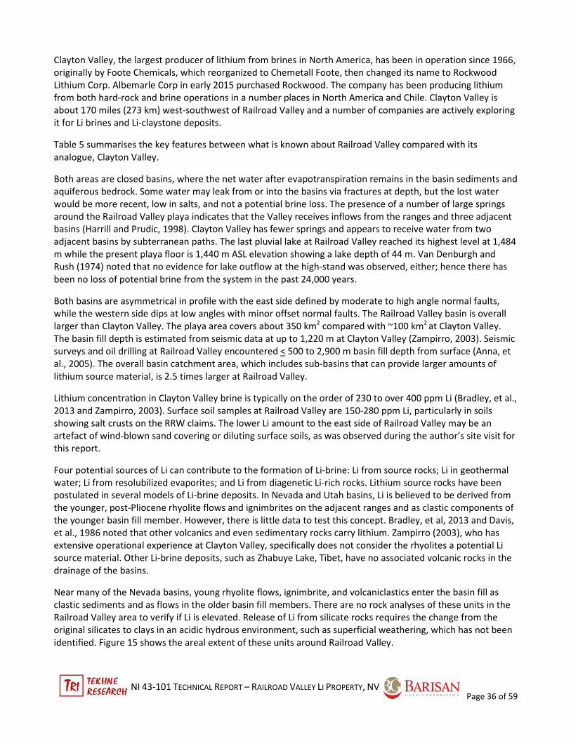
Clayton Valley, the largest producer of lithium from brines in North America, has been in operation since 1966,
originally by Foote Chemicals, which reorganized to Chemetall Foote, then changed its name to Rockwood
Lithium Corp. Albemarle Corp in early 2015 purchased Rockwood. The company has been producing lithium
from both hard-rock and brine operations in a number places in North America and Chile. Clayton Valley is
about 170 miles (273 km) west-southwest of Railroad Valley and a number of companies are actively exploring
it for Li brines and Li-claystone deposits.
Table 5 summarises the key features between what is known about Railroad Valley compared with its
analogue, Clayton Valley.
Both areas are closed basins, where the net water after evapotranspiration remains in the basin sediments and
aquiferous bedrock. Some water may leak from or into the basins via fractures at depth, but the lost water
would be more recent, low in salts, and not a potential brine loss. The presence of a number of large springs
around the Railroad Valley playa indicates that the Valley receives inflows from the ranges and three adjacent
basins (Harrill and Prudic, 1998). Clayton Valley has fewer springs and appears to receive water from two
adjacent basins by subterranean paths. The last pluvial lake at Railroad Valley reached its highest level at 1,484
m while the present playa floor is 1,440 m ASL elevation showing a lake depth of 44 m. Van Denburgh and
Rush (1974) noted that no evidence for lake outflow at the high-stand was observed, either; hence there has
been no loss of potential brine from the system in the past 24,000 years.
Both basins are asymmetrical in profile with the east side defined by moderate to high angle normal faults,
while the western side dips at low angles with minor offset normal faults. The Railroad Valley basin is overall
larger than Clayton Valley. The playa area covers about 350 km2 compared with ~100 km2 at Clayton Valley.
The basin fill depth is estimated from seismic data at up to 1,220 m at Clayton Valley (Zampirro, 2003). Seismic
surveys and oil drilling at Railroad Valley encountered < 500 to 2,900 m basin fill depth from surface (Anna, et
al., 2005). The overall basin catchment area, which includes sub-basins that can provide larger amounts of
lithium source material, is 2.5 times larger at Railroad Valley.
Lithium concentration in Clayton Valley brine is typically on the order of 230 to over 400 ppm Li (Bradley, et al.,
2013 and Zampirro, 2003). Surface soil samples at Railroad Valley are 150-280 ppm Li, particularly in soils
showing salt crusts on the RRW claims. The lower Li amount to the east side of Railroad Valley may be an
artefact of wind-blown sand covering or diluting surface soils, as was observed during the author’s site visit for
this report.
Four potential sources of Li can contribute to the formation of Li-brine: Li from source rocks; Li in geothermal
water; Li from resolubilized evaporites; and Li from diagenetic Li-rich rocks. Lithium source rocks have been
postulated in several models of Li-brine deposits. In Nevada and Utah basins, Li is believed to be derived from
the younger, post-Pliocene rhyolite flows and ignimbrites on the adjacent ranges and as clastic components of
the younger basin fill member. However, there is little data to test this concept. Bradley, et al, 2013 and Davis,
et al., 1986 noted that other volcanics and even sedimentary rocks carry lithium. Zampirro (2003), who has
extensive operational experience at Clayton Valley, specifically does not consider the rhyolites a potential Li
source material. Other Li-brine deposits, such as Zhabuye Lake, Tibet, have no associated volcanic rocks in the
drainage of the basins.
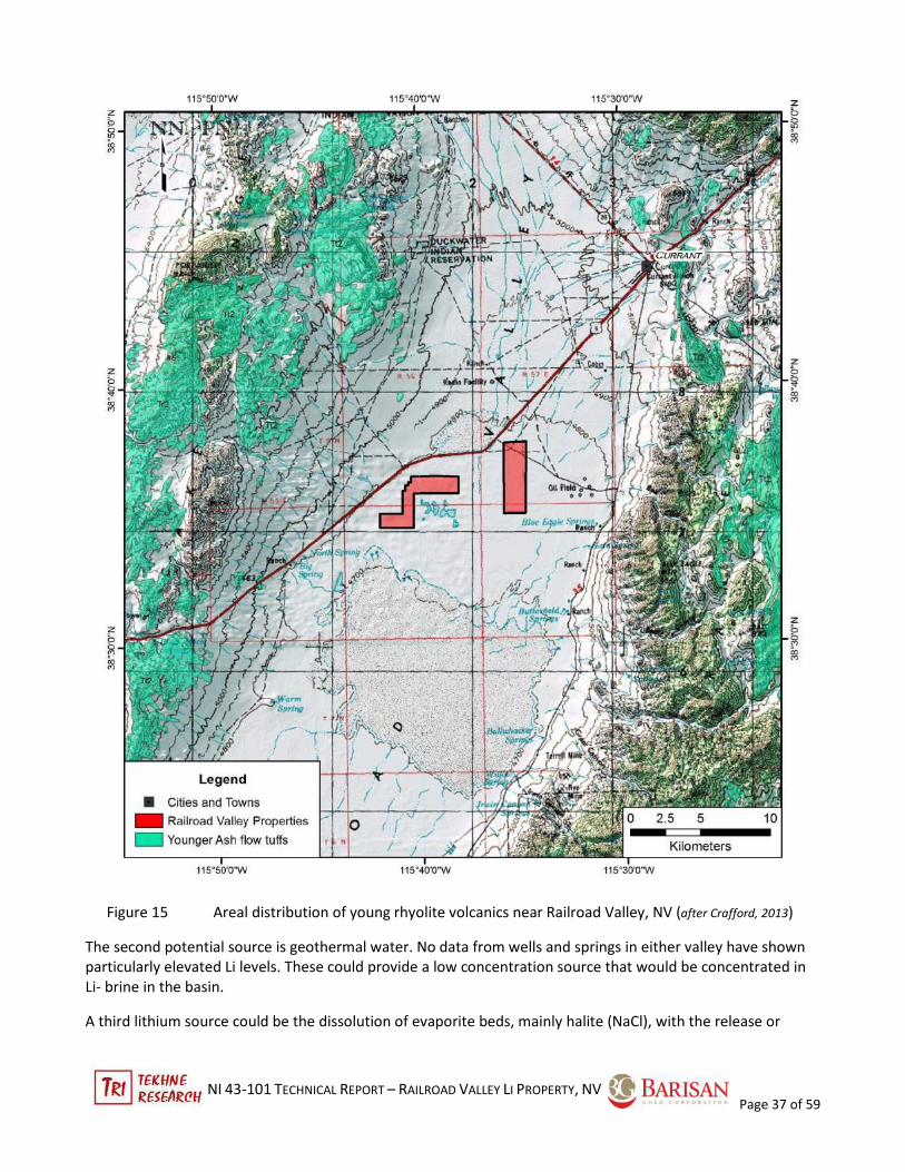
Near many of the Nevada basins, young rhyolite flows, ignimbrite, and volcaniclastics enter the basin fill as
clastic sediments and as flows in the older basin fill members. There are no rock analyses of these units in the
Railroad Valley area to verify if Li is elevated. Release of Li from silicate rocks requires the change from the
original silicates to clays in an acidic hydrous environment, such as superficial weathering, which has not been
identified. Figure 15 shows the areal extent of these units around Railroad Valley.
NI 43-101 TECHNICAL REPORT – RAILROAD VALLEY LI PROPERTY, NV
Page 37 of 59
Figure 15 Areal distribution of young rhyolite volcanics near Railroad Valley, NV (after Crafford, 2013)
The second potential source is geothermal water. No data from wells and springs in either valley have shown
particularly elevated Li levels. These could provide a low concentration source that would be concentrated in
Li- brine in the basin.
A third lithium source could be the dissolution of evaporite beds, mainly halite (NaCl), with the release or

NI 43-101 TECHNICAL REPORT – RAILROAD VALLEY LI PROPERTY, NV
Page 38 of 59
resolubilization of Li into young brine. This would be a three-step process where the salts were derived from
various sources, then concentrated into evaporites and bittern waters. These would be buried and the bittern
would retained in the crystallised evaporate. Later, under more humid conditions, basin groundwater would
dissolve the evaporite and release to bittern water with its charge of highly soluble elements, such as Li. In
Clayton Valley, Davis, et al., 1986, using oxygen isotopes and brine chemistry at Clayton Valley, showed that
the Li-brines there were not derived from particularly hot waters or directly from concentration by
evaporation. The isotope profiles of a number of wells and springs around Clayton Valley indicated a normal
meteoric water source with molar concentrations of Na, Mg, and Cl expected from evaporation, but these
were not the Li-brines. The unique isotope and chemical profile of the Li-brine indicated that it resulted from
the dissolution of the halite evaporate beds and the release of lithium in bittern, the water remaining after
precipitation of halite (NaCl).The molar ratios of Na:Cl and Mg:Cl were systematically close to saturated
stoichiometry of halite (NaCl 1:1 and MgCl2 1:2).
Li is often associated with evaporite beds (halite, sylvite, carbonates, and borates). This is the case in the large
Salar de Atacama and Salar de Uyuni playas in Chile and Bolivia as well as at Clayton Valley. Oil chip logs
recorded minor evaporite in one hole at Railroad Valley;
The presence of hot water springs, either geothermal from intrusives or deep circulation, can enhance
diagenesis and the release of Li into groundwater for concentration into Li-brine. Hot springs in both valleys
appear to be located on steep-dipping faults on the margins of the basins, but do not directly form brines. The
playa brines at Clayton Valley are < 36°C (Zampirro (2003); NBMG, 2014). Zampirro (2003) also showed that
the Li-brine aquifers were constrained with flow control between several steep faults in the younger basin fill
member. The presence of similar structures could be important at Railroad Valley, but are not known at
present.
The fourth potential Li source proposed at Clayton Valley is the calcareous evaporite lacustrine sediments of
the older basin fill member. This unit outcrops on the east side of the valley and is actively being explored by
Cypress Developments Ltd. Li co-precipitated in carbonates, such as tufa and alkali carbonate minerals, has a
low solubility at groundwater temperatures 20°-60°C and thus would be removed from the Li-brine. Extraction
of Li from carbonates would require acid dissolution and has been a proven technology to date. Noram
Ventures Inc., operating nearby, is testing a leaching method for Li-bearing clays, such as hectorite, for direct
precipitation as Li-carbonate. Hectorite is a lithium-bearing smectite clay with 0.54% Li by weight (see
www.mindat.org/). The Li is bound in the silicate clay structure and has very low solubility in neutral pH water.
Metallurgical tests by the US Bureau of Mines and other found that the Li could be extracted by using acid
leaches, a more costly process than concentrating brines. As a Li source, the naturally bicarbonate/carbonate-
rich brines would not leach Li in silicates. It is more likely that diagenesis of lacustrine beds would lead to the
sequestration of Li from existing brines. In both cases, Li is removed from, not added to, Li brine reservoirs.
The heat source at Clayton Valley appears to be normal deep-basin groundwater circulation. Railroad Valley
has similar groundwater, based on well and spring water chemistry. It also has a deeper bedrock zone beneath
the basin fill members that reached temperatures exceeding 100°C where petroleum precursors are converted
to oil. The high-heat area coincides with the deeper part of the Railroad Valley basin, based on gravity data
(Figures 10 and 13 above). Since the petroleum migrated after the formation of the older basin fill member,
the heat may have enhanced diagenesis liberating potential Li to brine aquifers in the modern basin. Anna, et
al. (2005) proposed that the granite intrusion in the Grant Range was hydrothermally altered and may have
provided a higher than normal burial heat flux. The intrusive lies southeast of the heat area in Figure 13.
In summary, the analogy between Railroad Valley and Clayton Valley is strong. Both are closed, arid terminal
basins bounded by faults and filled with porous young sediments. The Railroad Valley basin is volumetrically

NI 43-101 TECHNICAL REPORT – RAILROAD VALLEY LI PROPERTY, NV
Page 39 of 59
larger, has a larger playa surface, and has a larger catchment area for source Li (see Figure 16). The presence of
soil samples in the same range as the Li-brine at Clayton Valley suggests similar concentration. The presence of
a broad heat source beneath the playa area is unique to oil formation.
Table 5 -- Comparison between Clayton Valley and Railroad Valley
. Aspect Clayton Valley Railroad Valley
Closed basin Yes Yes
*semi-graben, east side down Yes Yes; minor faulting on west margin
*playa area 100 km2 350 km2
*total basin catchment area (includes ~4,400 km2 (3 basins) ~10,700 km2 (4 basins) (see Fig. 11)
all basins draining into ultimate basin)
Basin fill depth 100 m to >1,220 m 1,200-2,900 m to base of basin fill
* basin gravity signal moderate > CV, coincides with heat source
Evapotranspiration Yes Yes
Potential Li source rocks felsic volcanics felsic volcanics; no Li data
[thought to be of low importance]
Li-rich lacustrine claystone Yes, on east side no outcrops of lacustrine
[coeval w/ Li-brine; likely does not contribute Li to brine]
Li brine concentration 230–400 ppm Li unknown
Li in soil samples 200-500 ppm Li 150-280 ppm Li
Presence of evaporites (halite, etc.) Yes: halite Yes: minor trona/gaylussite known
Hot springs surface temperatures 19.5°-36°C (playa) 17°-35°C
(to 88°C in shallow geothermal wells)
Heat source none recorded locally high heat flux shown beneath
groundwater circulation by playa by oil maturation; deep groundwater
δO signature in groundwater geothermal in Bacon Flats area related to
granitic intrusion
Faults & trap rock in fill Yes (faults) Yes volcanic beds & faults (seismic)
Age of younger volcanic beds < 2.5 Ma < 2.5 Ma
Age of tuff alteration/brine formation 24,000 to 6,000 YBP unknown

NI 43-101 TECHNICAL REPORT – RAILROAD VALLEY LI PROPERTY, NV
Page 40 of 59
Figure 16 Total catchment basins draining into Railroad and Clayton Valleys, NV
(Nevada Dept. of Water Resources database 2016 annotated by author)
9 EXPLORATION
No exploration has been done by the Optionor. All information is discussed in Section 6, History.
NI 43-101 TECHNICAL REPORT – RAILROAD VALLEY LI PROPERTY, NV
Page 41 of 59
10. DRILLING
As of the report date, neither the Optionor nor the Issuer has undertaken any drilling on the Railroad Valley
Property.
11 SAMPLE PREPARATION, ANALYSES AND SECURITY
11.1 NURE-HSST
Regional sampling for uranium, among other geochemically related elements, including lithium, was
conducted by various US government agencies between 1973 and 1986 under the National Uranium Resource
Evaluation (NURE)-Hydrogeochemical and Stream Sediment Reconnaissance (HSST) program. It was a US-wide
assessment of uranium and secondarily other elements in soils and waters. The program data now is managed
by the US Geological Survey and forms their National Geochemical Survey Database
(http://mrdata.usgs.gov/geochem/). Although the data from NURE presented in this report is historical,
information on the sampling, analytical, and general QA/QC procedures exists (Arendt et al., 1979). The
manual establishes procedures for hydrogeochemical and stream sediments samples, but not to soil samples
specifically. The author has assumed that the general collection and analytical procedures for stream sediment
samples was used for soil samples as well, where applicable.
In the Railroad Valley basin, over 346 surface soil samples were collected in 1980. These varied in soil type, so
they are reconnaissance level quality only. The field technician completed a standard form describing the
sample location and site, material collected, and proximity to man-made features that could contaminate the
sample chemistry. Samples were collected no closer than 25 m upslope of potential contamination. The plastic
collection scoop was cleaned by plunging it in the soil nearby several times before collecting the sample. At
least six scoops were taken two to three metres apart and placed in a marked bag and sealed with vinyl tape.
Enough sample material was collected to yield at least 25 grams of <100-mesh fines after sieving. No protocols
for sample handling or shipment were discussed in the manual.
The samples were received and logged in at the Oak Ridge Gaseous Diffusion Plant Laboratory (ORGDP) in
Tennessee where a lab code was assigned to each sample for tracking purposes. Quality control samples were
added to the sample stream. The sample was dried at 85°C, blended, and screened to provide at least 5 grams
of <100-mesh fines. A 0.25 g portion was mixed with 5 ml concentrated nitric acid then 5 ml concentrated
hydrofluoric acid in a 100-ml Teflon beaker. The sample is dried on a hot-plate just to dryness, then dissolved
in 20 ml of 30% nitric acid. The contents of the beaker were transferred to a 50-ml centrifuge tube and diluted
to volume with distilled water. The solution is used for analysis.
The OR7 analytical technique used was Inductively Coupled Plasma Atomic Emission Spectral Analysis
(ICP/AES) that tested 31 elements, including lithium and associated potential brine elements (boron,
potassium, sodium, calcium, barium, magnesium, strontium, and phosphorus) (Arendt et al., 1979). The liquid
sample is aspirated directly into the ICP/AES plasma source with no further preparation. The results are
discussed in Section 9 and analyses and QA/QC in Section 11.
11.2 Lab Certification & Relation to Issuer
No mention of external laboratory certification was made in the report by Arendt et al (1979). The ORGDP Lab
essentially was a US government facility and relied on internal QA/QC procedures, which were supervised by a
group independent of the laboratories.
The Issuer has no relation in any manner with the ORGDP Laboratories.

NI 43-101 TECHNICAL REPORT – RAILROAD VALLEY LI PROPERTY, NV
Page 42 of 59
11.3 Opinion of Sample Preparation, Analysis, and Security
The procedures used by ORGDP Laboratory were adequately documented for the time. The sample
preparation and analytical methods are those routinely used in certified commercial laboratories today.
Procedures for sample description and verification in the field and in the lab were well-organized .The samples
appear to have been treated correctly. The author believes that the sample preparation, analysis, and security
aspects were adequate for the purposes of this report.
The data cited is historical in nature and should be used for information purposes only.
12 DATA VERIFICATION
12.1 NURE-HSST
Given the reconnaissance nature of the soil sampling conducted in the NURE-HSST program, no QA-QC control
samples were inserted into the sample stream in the field. Samples were subject to the ORGDP Laboratories
internal QA-QC procedures, which were managed by an internal department operating independently of the
analytical laboratory.
12.2 Opinion of Data Verification
The author believes that the data is adequate for the purposes of this report.
13 MINERAL PROCESSING & METALLURGICAL TESTING
Not applicable since no samples for Li-brine or bedrock material has been collected on the Railroad Valley
Property.
14 MINERAL RESOURCE ESTIMATES
There is no current resource estimation associated with the Railroad Valley Property.
15 MINERAL RESERVE ESTIMATES
There is no current reserve estimation associated with the Railroad Valley Property.
16 MINING METHODS
Not applicable
17 RECOVERY METHODS
Not applicable
18 PROJECT INFRASTRUCTURE
Not applicable.
19 MARKET STUDIES AND CONTRACTS
Not applicable

NI 43-101 TECHNICAL REPORT – RAILROAD VALLEY LI PROPERTY, NV
Page 43 of 59
20 ENVIRONMENTAL STUDIES, PERMITTING, AND SOCIAL OR COMMUNITY IMPACTS
Not applicable.
21 CAPITAL AND OPERATING COSTS
Not applicable
22 ECONOMIC ANALYSIS
Not applicable
23 ADJACENT PROPERTIES
Placer Ventures of Moab, Utah has located placer claims south and east of RRW, as witnessed by the author on
site visit on 9 August 2016. Oroplata Resources Inc. issued a news release on 1 June 2016 announcing a binding
agreement with an unnamed Optionor to acquire 500 claims in Railroad Valley for shares with an option for
another 600 claims. The 29 July 2016 Oroplata news release stated that it had optioned 700 additional placer
claims for a total of 1,200 placer claims (~24,000 acres or 9,713 ha), presumable from the same Optionor. The
claim locator has 90 days from the initial staking date to register the claims with Nye County and the BLM. In
its 29 July news release, Oroplata stated that it expects the transfer of claims to occur on or before 31 August
2016 into the name of its Nevada subsidiary. Whether the Placer Venture and Oroplata claims are the same is
unknown at the date of this report.
As of the report date, the registration of the claims neither in whole or nor in part for either Oroplata or for
Placer Ventures has been posted on either the BLM Nevada or Nye County online claims websites.
24 OTHER RELEVANT DATA AND INFORMATION
There are no additional data or material information known to the author about the subject property as of the
date of this report.
25 INTERPRETATION AND CONCLUSIONS
25.1 Interpretation
Railroad Valley has many similarities to the Clayton Valley lithium area, which is 200 km to the west-southwest.
Details are discussed at length above. Both are closed, arid graben basins with evapotranspirative formation of
surface playa sediments enriched in lithium salts The Railroad Valley basin catchment area is about 250%
larger and its playa surface area also is about 350% larger. Basin fill, as determined by seismic surveys and oil
well drilling, is about twice that of Clayton Valley. The younger volcanics occur on both bounding ranges, dip
into the basin, and volcaniclastics have been logged in the older and younger basin fill members as a result of
oil exploration. Since Railroad Valley produces about 90%of Nevada’s oil since 1954, many studies of oil
formation have been made. Anna, et al., (2005) defined a high heat-flow regime in the Paleozoic basement
carbonates that was at least 100°C, hot enough to mature petroleum precursors into oil that migrated into
flanking productive oil fields that extend into the lowest horizons of the older basin fill member at the Trap
Springs field. The variations in oil field characteristics indicate that there are local controls, such as cross faults
and undefined migration routes that can affect both bedrock as well as basin fill. Seismic profiles show that
cross-faults occur in the younger basin fill member as well. At Clayton Valley, Albemarle produces Li from six
aquifers, each with its own features, and cross-fault control often limits brine pools and protects them from
lower salinity inflow caused by brine extraction (Zampirro, 2003).

NI 43-101 TECHNICAL REPORT – RAILROAD VALLEY LI PROPERTY, NV
Page 44 of 59
Recognition of several lineaments defined by springs and topography on and southwest of the RRW claims
approximates presentation of mature oil source formations, gravity, and Li in reconnaissance soil samples can
help plan geophysical and geochemical survey interpretations.
25.2 Conclusions
With many features similar to Clayton Valley and with no exploration work targeting lithium to the date of this
report, Railroad Valley represents a new and untested target for lithium brine. The Railroad Valley brine
exploration can build on both the dense existing oil field data and the experiences at Clayton Valley and other
Li-brine basins to target potential brine aquifers.
25.3 Risks
The Railroad Valley Lithium Property is a green-fields project. There has been no exploration pertaining to
lithium, either as brine or bedrock deposit. While many similarities exist between the productive Clayton
Valley analogue and Railroad Valley, there is a risk that future exploration may not locate a viable lithium
deposit. Risks are the normal geological ones including: the presence of brine aquifers carrying lithium, their
continuity and connections to establish a deposit of sufficient size and Li grade, and technical processing
methods to produce a marketable product. Other risks can include: access to water rights for processing; area
for evaporation ponds if required, adequate power and other infrastructure requirements for development
and processing.
26 RECOMMENDATIONS
The author recommends a two-phase work program at Railroad Valley with further works dependent on
results. Phase 1 would focus on synthesizing available well-logs (geological and electronic), gravity, and seismic
data, all of which can be purchased through oil and gas data brokers. Railroad Valley’s 60-year history of oil
exploration will have a large data set compared with other potential Li-brine basins in Nevada and Utah. The
distribution of oil, gas, and water wells at Railroad Valley are shown on Figure 17.

NI 43-101 TECHNICAL REPORT – RAILROAD VALLEY LI PROPERTY, NV
Page 45 of 59
Figure 17 Oil, gas, and water wells in Railroad Valley (after NV-O&G, 2013 & NV-Water, 2016)
Magnetotelluric (MT) geophysical surveys would augment the historical geophysical and geological
information and help to define conductive aquifers and non-conductive cap layers. MT depth penetration is
better than CSAMT, and so is preferred for RRE. Two lines would cross RRW and a third longer line would
diagonally cross RRVE east of the Spencer-Federal #32-29 well to test the depth to bedrock and potential
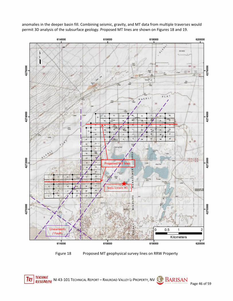
NI 43-101 TECHNICAL REPORT – RAILROAD VALLEY LI PROPERTY, NV
Page 46 of 59
anomalies in the deeper basin fill. Combining seismic, gravity, and MT data from multiple traverses would
permit 3D analysis of the subsurface geology. Proposed MT lines are shown on Figures 18 and 19.
Figure 18 Proposed MT geophysical survey lines on RRW Property
SHELL LOCKES #1
Proposed MT lines
Lineaments
/ Faults

NI 43-101 TECHNICAL REPORT – RAILROAD VALLEY LI PROPERTY, NV
Page 47 of 59
Figure 19 Proposed MT geophysical soil geochemical survey lines on RRE Property
Soil geochemistry would be done using an auger to penetrate surface contamination from wind-blown dust,
etc. Four lines across RRE claims would collect 50 samples on 150-m stations (Figure 19) and grid sampling at
RRW on 150-m stations would add 500 samples. In order to test Li and associated salts from potential brine
sources, a selective alkaline leach should be done on samples and analysed by ICP-MS. The purpose of the
Spencer-Federal #32-29
Proposed MT line
Proposed soil
geochem lines

NI 43-101 TECHNICAL REPORT – RAILROAD VALLEY LI PROPERTY, NV
Page 48 of 59
alkaline leach is to track Li sourced from brines, since it mimics the pH of brines. Many common analytical
digestion methods use acid, which can incompletely strip ionic salts from diagenetically altered silicates and
carbonates; these Li sources would not be available for brine concentration.
The Phase 1 program as laid out would provide a sound knowledge platform for selecting drill holes in Phase 2.
Currency is in USD, exclusive of applicable taxes.
Phase 1 ($ 88,500)
1 Collect and synthesize existing oil field data (seismic, gravity, and drill logs) $ 12,000
2 MT survey RRE 1 line 5.5 ln-km & RRW 2 lines 6.7 km = 12 ln-km @ $4000/ln-km $ 48,000
3 Sample playa soils (auger on 150-m stn spacing), 4 men x $400/mn-day all-in x 4 days $ 6,500
4 Sample analysis @ALS, Reno, 550 spls @$40 ea ICP $ 22,000
Total $ 88,500
Phase 2 works would focus on drilling to test targets defined in Phase 1. RRVW, because of its proximity to the
western part of the basin, shows evidence of cross-faults that may localise brine aquifers. Three holes are
contemplated. RRVE lies over the deep part of the basin and one deeper hole would test brine potential at
deeper levels.
Phase 2 ($ 280,000)
1. Drill 3 holes on RRW total 650 m $ 125,000
2. Drill 1 hole on RRE total 800 m $ 155,000
Total $ 280,000
27 REFERENCES
Anna, L.O., Roberts, L.N.R., and Potter, C.J., 2005. Geologic assessment of undiscovered oil and gas in
the Paleozoic-Tertiary composite total petroleum system of the eastern Great Basin, Nevada and Utah:
in USGS Digital Data Series DDS-69-L, Ch. 2, 50p.
Arendt, J.W., Butz, T.R., Cagle, G.W., Kane, V.E., and Nichols, C.E., 1979. Hydrogeochemical and stream
sediment reconnaissance procedures of the Uranium Resource Evaluation project: Union Carbide
Corporation, Nuclear Division, Oak Ridge Gaseous Diffusion Plant, Oak Ridge, Tenn., K/UR-100, U.S.
Department of Energy, Grand Junction, Colo., GJBX-32(80), 55 p.
Bradley, D., Munk, L., Jochens, H., Hynek, S., and Labay, K., 2013. A preliminary deposit model for
lithium brines: USGS Open File OF13-1006, 9 p.
(also available at https://www.pubs.usgs.gov/of/2013/1006/OF13-1006.pdf )
Camilleri, P.A., 2013. Geologic map and structure of west-central Grant Range, Nye County, Nevada:
GSA Digital Map and Chart Series 14, 25p.
Crafford, A.E.J., 2007. Geologic map of Nevada: USGS Data Series 249, 1 CD-ROM, 46 p., 1 plate. (also available
at https://www.pubs.usgs.gov/ds/2007/249 )
Davis, J.R., Friedman, I., and Gleason, J.D., 1986. Origins of lithium-rich brines, Clayton Valley, Nevada in USGS
Bull 1622, Ch. L, p 131-138.
NI 43-101 TECHNICAL REPORT – RAILROAD VALLEY LI PROPERTY, NV
Page 49 of 59
Harrill, J.R. and Prudic, D.E., 1998. Aquifer systems of the Great Basin regions of Nevada, Utah, and adjacent
states – Summary report: USGS Prof Paper 1409-A, 75p.
Nevada Bureau of Mines and Geology (NBMG), 2014. Geothermal site description, updated 2014 available at
data.nbmg.unr.edu/Public/Geothermal/SiteDescriptions/SilverPeak_ClaytonValley.pdf
Nevada Dept. of Water Resources, 2016. Basin of Nevada (available at )
NV-O&G, 2013. Oil and Gas well locations, Nevada GIS database (available at https://gisweb.unr.edu/OilGas/ )
NV-Water, 2016. Water well locations, Nevada; (available at http://water.nv.gov/data/welllog/ )
Oppliger, G.L., 2003. Improved resolution GIS-compatible gravity and aeromagnetic data sets for Great Basin
geothermal exploration. Nat’l Geothermal Data System (NGDS) data set: Shallow crusted residual (isostatic)
gravity anomalies. (also available at
http://able1.mines.unr.edu/Geophysics_website/Greatbasin_geophysics1/index.htm )
Plume. R.W., 1996. Hydrogeologic framework of aquifer systems in the Great Basin region; USGS Prof Paper
1409-B, 64p + 5 plates/
Smith, Steven M., 2006. National Geochemical Database—Reformatted Data from the National Uranium
Resource Evaluation (NURE) Hydrogeochemical and Stream Sediment Reconnaissance (HSSR) Program, USGS
OF Rept 97-492, ver 1.40 (2006)
US Geological Survey, 2016. National Geochemical Survey Database (http://mrdata.usgs.gov/geochem/ ).
Van Denburgh, A.S. and Rush, F.E., 1974. Water resources appraisal of the Railroad and Penoyer Valleys, east-
central Nevada: Nev Dept Water Conservation & Natl Res & USGS, Water reconnaissance series, Rept. 60, 72p.
Vreeland, J.H. and Berrong, B.H., 1979. Seismic exploration in Railroad Valley, Nevada in Rocky Mtn Assn Geol
– Utah Geol Assn – 1979 Basin and Range Symposium, p. 557-569.
Zampirro, D., 2003. Hydrogeology of Clayton Valley brine deposits, Esmeralda, County, Nevada in Castor, S.B.,
Papke, K.P., and Meeuig, R.O.. eds: Proceedings of the 39th Forum on Industrial Minerals, May 18-24 2003;
NBMG Spec Pub 33, p271-280.

NI 43-101 TECHNICAL REPORT – RAILROAD VALLEY LI PROPERTY, NV
Page 50 of 59
. APPENDIX A
RAILROAD VALLEY PROJECT Nye County, Nevada
RRE and RRW Unpatented Placer Claims
Owned by Arizona Lithium Co., Ltd.
RRE Claims: Township 80 North, Range 57 East, Section 5
Township 90 North, Range 57 East, Sections 20, 23, 29, and 32
100 Claims
RRW Claims: Township 80 North, Range 56 East, Section 4 and 5
Township 90 North, Range 56 East, Sections 26-28 and 33-35
99 Claims
Meridian 21: Mt. Diablo Base Line & Meridian (MDB&M)
Note: All claims on Federal lands have the common anniversary date of 1 September each year. Annual fees
and applicable filings are due before that date
Claim Name Serial Number Mer Twp Rng Sec Quad Location Date Last
Assessment
RRE 1 NMC1123208 21 0090N 0570E 020 NW 04/22/2016 2017
RRE 2 NMC1123209 21 0090N 0570E 020 NW 04/22/2016 2017
RRE 3 NMC1123210 21 0090N 0570E 020 NW 04/22/2016 2017
RRE 4 NMC1123211 21 0090N 0570E 020 NW 04/22/2016 2017
RRE 5 NMC1123212 21 0090N 0570E 020 SW 04/22/2016 2017
RRE 6 NMC1123213 21 0090N 0570E 020 SW 04/22/2016 2017
RRE 7 NMC1123214 21 0090N 0570E 020 SW 04/22/2016 2017
RRE 8 NMC1123215 21 0090N 0570E 020 SW 04/22/2016 2017
RRE 9 NMC1123216 21 0090N 0570E 020 SW 04/22/2016 2017
RRE 10 NMC1123217 21 0090N 0570E 020 SW 04/22/2016 2017
RRE 11 NMC1123218 21 0090N 0570E 020 SW 04/22/2016 2017
RRE 12 NMC1123219 21 0090N 0570E 020 SW 04/22/2016 2017

NI 43-101 TECHNICAL REPORT – RAILROAD VALLEY LI PROPERTY, NV
Page 51 of 59
Claim Name Serial Number Mer Twp Rng Sec Quad Location Date Last
Assessment
RRE 13 NMC1123220 21 0090N 0570E 029 NW 04/22/2016 2017
RRE 14 NMC1123221 21 0090N 0570E 029 NW 04/22/2016 2017
RRE 15 NMC1123222 21 0090N 0570E 029 NW 04/22/2016 2017
RRE 16 NMC1123223 21 0090N 0570E 029 NW 04/22/2016 2017
RRE 17 NMC1123224 21 0090N 0570E 029 NW 04/22/2016 2017
RRE 18 NMC1123225 21 0090N 0570E 029 NW 04/22/2016 2017
RRE 19 NMC1123226 21 0090N 0570E 029 NW 04/22/2016 2017
RRE 20 NMC1123227 21 0090N 0570E 029 NW 04/22/2016 2017
RRE 21 NMC1123228 21 0090N 0570E 029 SW 04/22/2016 2017
RRE 22 NMC1123229 21 0090N 0570E 029 SW 04/22/2016 2017
RRE 23 NMC1123230 21 0090N 0570E 029 SW 04/22/2016 2017
RRE 24 NMC1123231 21 0090N 0570E 029 SW 04/22/2016 2017
RRE 25 NMC1123232 21 0090N 0570E 029 SW 04/22/2016 2017
RRE 26 NMC1123233 21 0090N 0570E 029 SW 04/22/2016 2017
RRE 27 NMC1123234 21 0090N 0570E 029 SW 04/22/2016 2017
RRE 28 NMC1123235 21 0090N 0570E 029 SW 04/22/2016 2017
RRE 29 NMC1123236 21 0090N 0570E 032 NW 04/22/2016 2017
RRE 30 NMC1123237 21 0090N 0570E 032 NW 04/22/2016 2017
RRE 31 NMC1123238 21 0090N 0570E 032 NW 04/22/2016 2017
RRE 32 NMC1123239 21 0090N 0570E 032 NW 04/22/2016 2017
RRE 33 NMC1123240 21 0090N 0570E 032 NW 04/22/2016 2017
RRE 34 NMC1123241 21 0090N 0570E 032 NW 04/22/2016 2017
RRE 35 NMC1123242 21 0090N 0570E 032 NW 04/21/2016 2017
RRE 36 NMC1123243 21 0090N 0570E 032 NW 04/21/2016 2017
RRE 37 NMC1123244 21 0090N 0570E 032 SW 04/21/2016 2017

NI 43-101 TECHNICAL REPORT – RAILROAD VALLEY LI PROPERTY, NV
Page 52 of 59
Claim Name Serial Number Mer Twp Rng Sec Quad Location Date Last
Assessment
RRE 38 NMC1123245 21 0090N 0570E 032 SW 04/21/2016 2017
RRE 39 NMC1123246 21 0090N 0570E 032 SW 04/21/2016 2017
RRE 40 NMC1123247 21 0090N 0570E 032 SW 04/21/2016 2017
RRE 41 NMC1123248 21 0090N 0570E 032 SW 04/21/2016 2017
RRE 42 NMC1123249 21 0090N 0570E 032 SW 04/21/2016 2017
RRE 43 NMC1123250 21 0090N 0570E 032 SW 04/21/2016 2017
RRE 44 NMC1123251 21 0090N 0570E 032 SW 04/21/2016 2017
RRE 45 NMC1123252 21 0080N 0570E 005 NW 04/21/2016 2017
RRE 46 NMC1123253 21 0080N 0570E 005 NW 04/21/2016 2017
RRE 47 NMC1123254 21 0080N 0570E 005 NW 04/21/2016 2017
RRE 48 NMC1123255 21 0080N 0570E 005 NW 04/21/2016 2017
RRE 49 NMC1123256 21 0080N 0570E 005 NW 04/21/2016 2017
RRE 50 NMC1123257 21 0080N 0570E 005 NW 04/21/2016 2017
RRE 51 NMC1123258 21 0090N 0570E 020 NE 04/22/2016 2017
RRE 52 NMC1123259 21 0090N 0570E 020 NE 04/22/2016 2017
RRE 53 NMC1123260 21 0090N 0570E 020 NE 04/22/2016 2017
RRE 54 NMC1123261 21 0090N 0570E 020 NE 04/22/2016 2017
RRE 55 NMC1123262 21 0090N 0570E 020 SE 04/22/2016 2017
RRE 56 NMC1123263 21 0090N 0570E 020 SE 04/22/2016 2017
RRE 57 NMC1123264 21 0090N 0570E 020 SE 04/22/2016 2017
RRE 58 NMC1123265 21 0090N 0570E 020 SE 04/22/2016 2017
RRE 59 NMC1123266 21 0090N 0570E 020 SE 04/22/2016 2017
RRE 60 NMC1123267 21 0090N 0570E 020 SE 04/22/2016 2017
RRE 61 NMC1123268 21 0090N 0570E 020 SE 04/22/2016 2017
RRE 62 NMC1123269 21 0090N 0570E 020 SE 04/22/2016 2017

NI 43-101 TECHNICAL REPORT – RAILROAD VALLEY LI PROPERTY, NV
Page 53 of 59
Claim Name Serial Number Mer Twp Rng Sec Quad Location Date Last
Assessment
RRE 63 NMC1123270 21 0090N 0570E 029 NE 04/22/2016 2017
RRE 64 NMC1123271 21 0090N 0570E 029 NE 04/22/2016 2017
RRE 65 NMC1123272 21 0090N 0570E 029 NE 04/22/2016 2017
RRE 66 NMC1123273 21 0090N 0570E 029 NE 04/22/2016 2017
RRE 67 NMC1123274 21 0090N 0570E 029 NE 04/22/2016 2017
RRE 68 NMC1123275 21 0090N 0570E 029 NE 04/22/2016 2017
RRE 69 NMC1123276 21 0090N 0570E 029 NE 04/22/2016 2017
RRE 70 NMC1123277 21 0090N 0570E 029 NE 04/22/2016 2017
RRE 71 NMC1123278 21 0090N 0570E 029 SE 04/22/2016 2017
RRE 72 NMC1123279 21 0090N 0570E 029 SE 04/22/2016 2017
RRE 73 NMC1123280 21 0090N 0570E 029 SE 04/22/2016 2017
RRE 74 NMC1123281 21 0090N 0570E 029 SE 04/22/2016 2017
RRE 75 NMC1123282 21 0090N 0570E 029 SE 04/22/2016 2017
RRE 76 NMC1123283 21 0090N 0570E 029 SE 04/22/2016 2017
RRE 77 NMC1123284 21 0090N 0570E 029 SE 04/22/2016 2017
RRE 78 NMC1123285 21 0090N 0570E 029 SE 04/22/2016 2017
RRE 79 NMC1123286 21 0090N 0570E 032 NE 04/22/2016 2017
RRE 80 NMC1123287 21 0090N 0570E 032 NE 04/22/2016 2017
RRE 81 NMC1123288 21 0090N 0570E 032 NE 04/22/2016 2017
RRE 82 NMC1123289 21 0090N 0570E 032 NE 04/22/2016 2017
RRE 83 NMC1123290 21 0090N 0570E 032 NE 04/22/2016 2017
RRE 84 NMC1123291 21 0090N 0570E 032 NE 04/22/2016 2017
RRE 85 NMC1123292 21 0090N 0570E 032 NE 04/22/2016 2017
RRE 86 NMC1123293 21 0090N 0570E 032 NE 04/22/2016 2017
RRE 87 NMC1123294 21 0090N 0570E 032 SE 04/22/2016 2017

NI 43-101 TECHNICAL REPORT – RAILROAD VALLEY LI PROPERTY, NV
Page 54 of 59
Claim Name Serial Number Mer Twp Rng Sec Quad Location Date Last
Assessment
RRE 88 NMC1123295 21 0090N 0570E 032 SE 04/22/2016 2017
RRE 89 NMC1123296 21 0090N 0570E 032 SE 04/22/2016 2017
RRE 90 NMC1123297 21 0090N 0570E 032 SE 04/22/2016 2017
RRE 91 NMC1123298 21 0090N 0570E 023 SE 04/21/2016 2017
RRE 92 NMC1123299 21 0090N 0570E 032 SE 04/21/2016 2017
RRE 93 NMC1123300 21 0090N 0570E 032 SE 04/21/2016 2017
RRE 94 NMC1123301 21 0090N 0570E 032 SE 04/21/2016 2017
RRE 95 NMC1123302 21 0080N 0570E 005 NE 04/21/2016 2017
RRE 96 NMC1123303 21 0080N 0570E 005 NE 04/21/2016 2017
RRE 97 NMC1123304 21 0080N 0570E 005 NE 04/21/2016 201
RRE 98 NMC1123305 21 0080N 0570E 005 NE 04/21/2016 20167
RRE 99 NMC1123306 21 0080N 0570E 005 NE 04/21/2016 2017
RRE 100 NMC1123307 21 0080N 0570E 005 NE 04/21/2016 2017
RRW 1 NMC1123308 21 0080N 0560E 005 NE 04/23/2016 2017
RRW 2 NMC1123309 21 0080N 0560E 005 NE 04/23/2016 2017
RRW 3 NMC1123310 21 0080N 0560E 005 NE 04/23/2016 2017
RRW 4 NMC1123311 21 0080N 0560E 005 SE 04/23/2016 2017
RRW 5 NMC1123312 21 0080N 0560E 005 SE 04/23/2016 2017
RRW 6 NMC1123313 21 0080N 0560E 005 SE 04/23/2016 2017
RRW 7 NMC1123314 21 0080N 0560E 005 SE 04/23/2016 2017
RRW 8 NMC1123315 21 0080N 0560E 005 SE 04/23/2016 2017
RRW 9 NMC1123316 21 0080N 0560E 005 SE 04/23/2016 2017
RRW 10 NMC1123317 21 0080N 0560E 005 SE 04/23/2016 2017
RRW 11 NMC1123318 21 0080N 0560E 004 NW 04/23/2016 2017

NI 43-101 TECHNICAL REPORT – RAILROAD VALLEY LI PROPERTY, NV
Page 55 of 59
Claim Name Serial Number Mer Twp Rng Sec Quad Location Date Last
Assessment
RRW 12 NMC1123319 21 0080N 0560E 004 NW 04/23/2016 2017
RRW 13 NMC1123320 21 0080N 0560E 004 SW 04/23/2016 2017
RRW 14 NMC1123321 21 0080N 0560E 004 SW 04/23/2016 2017
RRW 15 NMC1123322 21 0080N 0560E 004 SW 04/23/2016 2017
RRW 16 NMC1123323 21 0080N 0560E 004 SW 04/23/2016 2017
RRW 17 NMC1123324 21 0080N 0560E 004 SW 04/23/2016 2017
RRW 18 NMC1123325 21 0080N 0560E 004 SW 04/23/2016 2017
RRW 19 NMC1123326 21 0080N 0560E 004 SW 04/23/2016 2017
RRW 20 NMC1123327 21 0080N 0560E 004 SW 04/23/2016 2017
RRW 21 NMC1123328 21 0090N 0560E 028 SE 04/23/2016 2017
RRW 22 NMC1123329 21 0090N 0560E 033 NE 04/23/2016 2017
RRW 23 NMC1123330 21 0090N 0560E 033 NE 04/23/2016 2017
RRW 24 NMC1123331 21 0090N 0560E 033 NE 04/23/2016 2017
RRW 25 NMC1123332 21 0090N 0560E 033 NE 04/23/2016 2017
RRW 26 NMC1123333 21 0090N 0560E 033 NE 04/23/2016 2017
RRW 27 NMC1123334 21 0090N 0560E 033 NE 04/23/2016 2017
RRW 28 NMC1123335 21 0090N 0560E 033 SE 04/23/2016 2017
RRW 29 NMC1123336 21 0090N 0560E 033 SE 04/23/2016 2017
RRW 30 NMC1123337 21 0090N 0560E 033 SE 04/23/2016 2017
RRW 31 NMC1123338 21 0090N 0560E 033 SE 04/23/2016 2017
RRW 32 NMC1123339 21 0090N 0560E 033 SE 04/23/2016 2017
RRW 33 NMC1123340 21 0090N 0560E 033 SE 04/23/2016 2017
RRW 34 NMC1123341 21 0090N 0560E 033 SE 04/23/2016 2017
RRW 35 NMC1123342 21 0090N 0560E 033 SE 04/23/2016 2017
RRW 36 NMC1123343 21 0080N 0560E 004 NE 04/23/2016 2017

NI 43-101 TECHNICAL REPORT – RAILROAD VALLEY LI PROPERTY, NV
Page 56 of 59
Claim Name Serial Number Mer Twp Rng Sec Quad Location Date Last
Assessment
RRW 37 NMC1123344 21 0080N 0560E 004 NE 04/23/2016 2017
RRW 38 NMC1123345 21 0080N 0560E 004 NE 04/23/2016 2017
RRW 39 NMC1123346 21 0080N 0560E 004 NE 04/23/2016 2017
RRW 40 NMC1123347 21 0080N 0560E 004 NE 04/23/2016 2017
RRW 41 NMC1123348 21 0080N 0560E 004 NE 04/23/2016 2017
RRW 42 NMC1123349 21 0080N 0560E 004 NE 04/23/2016 2017
RRW 43 NMC1123350 21 0080N 0560E 004 NE 04/23/2016 2017
RRW 44 NMC1123351 21 0080N 0560E 004 SE 04/23/2016 2017
RRW 45 NMC1123352 21 0080N 0560E 004 SE 04/23/2016 2017
RRW 46 NMC1123353 21 0080N 0560E 004 SE 04/23/2016 2017
RRW 47 NMC1123354 21 0080N 0560E 004 SE 04/23/2016 2017
RRW 48 NMC1123355 21 0080N 0560E 004 SE 04/23/2016 2017
RRW 49 NMC1123356 21 0080N 0560E 004 SE 04/23/2016 2017
RRW 50 NMC1123357 21 0080N 0560E 004 SE 04/23/2016 2017
RRW 51 NMC1123358 21 0080N 0560E 004 SE 04/23/2016 2017
RRW 52 NMC1123359 21 0090N 0560E 027 SW 04/23/2016 2017
RRW 53 NMC1123360 21 0090N 0560E 027 SW 04/23/2016 2017
RRW 54 NMC1123361 21 0090N 0560E 027 SW 04/23/2016 2017
RRW 55 NMC1123362 21 0090N 0560E 027 SW 04/23/2016 2017
RRW 56 NMC1123363 21 0090N 0560E 034 NW 04/23/2016 2017
RRW 57 NMC1123364 21 0090N 0560E 034 NW 04/23/2016 2017
RRW 58 NMC1123365 21 0090N 0560E 034 NW 04/23/2016 2017
RRW 59 NMC1123366 21 0090N 0560E 034 NW 04/23/2016 2017
RRW 60 NMC1123367 21 0090N 0560E 034 NW 04/23/2016 2017
RRW 61 NMC1123368 21 0090N 0560E 034 NW 04/23/2016 2017

NI 43-101 TECHNICAL REPORT – RAILROAD VALLEY LI PROPERTY, NV
Page 57 of 59
Claim Name Serial Number Mer Twp Rng Sec Quad Location Date Last
Assessment
RRW 62 NMC1123369 21 0090N 0560E 034 NW 04/23/2016 2017
RRW 63 NMC1123370 21 0090N 0560E 034 NW 04/23/2016 2017
RRW 64 NMC1123371 21 0090N 0560E 027 SE 04/23/2016 201
RRW 65 NMC1123372 21 0090N 0560E 027 SE 04/23/2016 20167
RRW 66 NMC1123373 21 0090N 0560E 027 SE 04/23/2016 2017
RRW 67 NMC1123374 21 0090N 0560E 027 SE 04/23/2016 2017
RRW 68 NMC1123375 21 0090N 0560E 034 NE 04/23/2016 2017
RRW 69 NMC1123376 21 0090N 0560E 034 NE 04/23/2016 2017
RRW 70 NMC1123377 21 0090N 0560E 034 NE 04/23/2016 2017
RRW 71 NMC1123378 21 0090N 0560E 034 NE 04/23/2016 2017
RRW 72 NMC1123379 21 0090N 0560E 034 NE 04/23/2016 2017
RRW 73 NMC1123380 21 0090N 0560E 034 NE 04/23/2016 2017
RRW 74 NMC1123381 21 0090N 0560E 034 NE 04/23/2016 2017
RRW 75 NMC1123382 21 0090N 0560E 034 NE 04/23/2016 2017
RRW 76 NMC1123383 21 0090N 0560E 026 SW 04/23/2016 2017
RRW 77 NMC1123384 21 0090N 0560E 026 SW 04/23/2016 2017
RRW 78 NMC1123385 21 0090N 0560E 026 SW 04/23/2016 2017
RRW 79 NMC1123386 21 0090N 0560E 026 SW 04/23/2016 2017
RRW 80 NMC1123387 21 0090N 0560E 035 NW 04/23/2016 2017
RRW 81 NMC1123388 21 0090N 0560E 035 NW 04/23/2016 2017
RRW 82 NMC1123389 21 0090N 0560E 035 NW 04/23/2016 2017
RRW 83 NMC1123390 21 0090N 0560E 035 NW 04/23/2016 2017
RRW 84 NMC1123391 21 0090N 0560E 035 NW 04/23/2016 2017
RRW 85 NMC1123392 21 0090N 0560E 035 NW 04/23/2016 2017
RRW 86 NMC1123393 21 0090N 0560E 035 NW 04/23/2016 2017

NI 43-101 TECHNICAL REPORT – RAILROAD VALLEY LI PROPERTY, NV
Page 58 of 59
Claim Name Serial Number Mer Twp Rng Sec Quad Location Date Last
Assessment
RRW 87 NMC1123394 21 0090N 0560E 035 NW 04/23/2016 2017
RRW 88 NMC1123395 21 0090N 0560E 026 SE 04/23/2016 2017
RRW 89 NMC1123396 21 0090N 0560E 026 SE 04/23/2016 2017
RRW 90 NMC1123397 21 0090N 0560E 026 SE 04/23/2016 2017
RRW 91 NMC1123398 21 0090N 0560E 026 SE 04/23/2016 2017
RRW 92 NMC1123399 21 0090N 0560E 035 NE 04/23/2016 2017
RRW 93 NMC1123400 21 0090N 0560E 035 NE 04/23/2016 2017
RRW 94 NMC1123401 21 0090N 0560E 035 NE 04/23/2016 2017
RRW 95 NMC1123402 21 0090N 0560E 035 NE 04/23/2016 2017
RRW 96 NMC1123403 21 0090N 0560E 035 NE 04/23/2016 2017
RRW 97 NMC1123404 21 0090N 0560E 035 NE 04/23/2016 2017
RRW 98 NMC1123405 21 0090N 0560E 035 NE 04/23/2016 2017
RRW 99 NMC1123406 21 0090N 0560E 035 NE 04/23/2016 2017