Embed Size (px)
Citation preview

Newcastle West Local Area Plan 2014 - 2020
August 2014
Volume 1
Forward Planning Pleanáil chun tosaigh

Newcastle West Local Area Plan 2014-2020 1
In accordance with the provisions of the Planning and Development Acts 2000 – 2013, Section 20 (4A), this Local Area Plan came into effect on 4th August 2014, four weeks from the date of its adoption by elected members of Limerick City and County Council on the 7th July 2014.

Newcastle West Local Area Plan 2014-2020 2
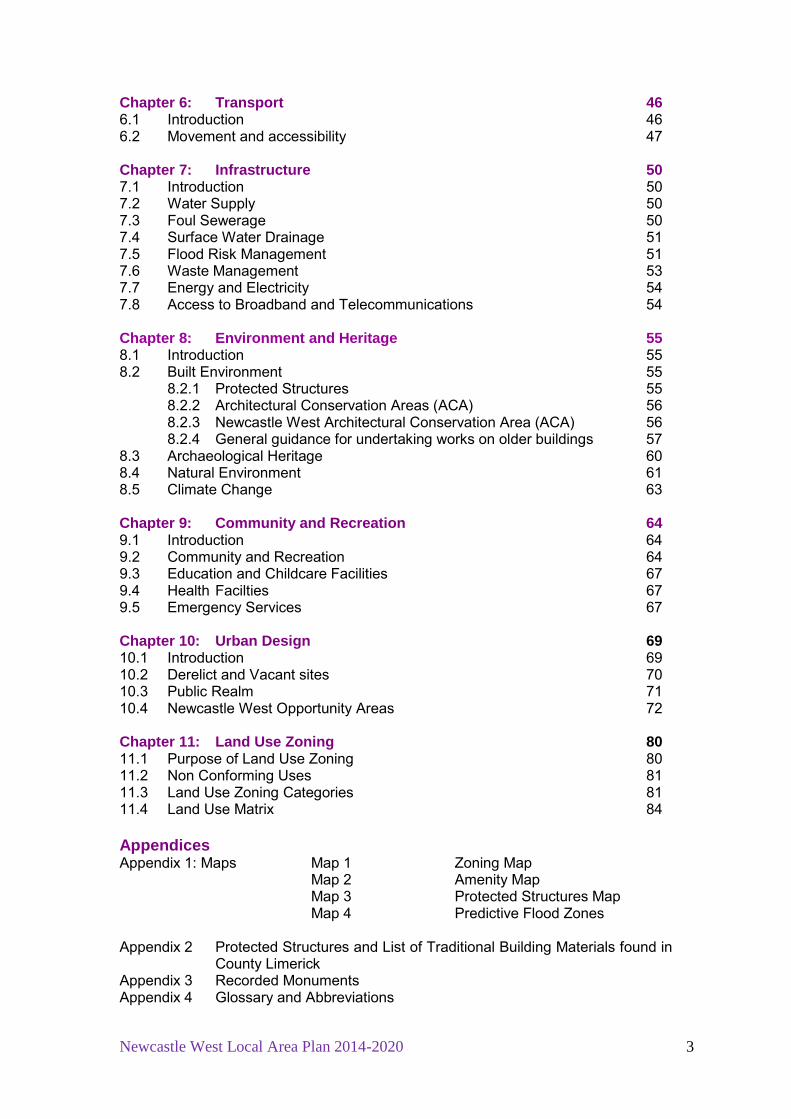
Table of Contents Chapter 1: Introduction 7 1.1 What is the Newcastle West Local Area Plan ( LAP)? 7 1.2 7 Plan Area1.3 The Review Process 8 1.3.1 Steps involved in the preparation of the LAP 8 1.3.2 Strategic Environmental Assessment (SEA) 9 1.3.3 Appropriate Assessment 9 1.3.4 Flood Risk Assessment 9 1.4 Planning Context 9
1.4.1 National Planning Context 10 1.4.2 Regional Planning Context 10 1.4.3 County Planning Context 12 1.4.4 Other Planning Guidelines 13
Chapter 2: Context 14 2.1 Geographical Context 14 2.2 Historic Evolution 14 2.3 Natural and Built Environment 18 2.4 Function 18 2.5 Demographic and Socio-economic Context 20 2.5.1 Population 20 2.5.2 Age Profile 21
2.5.3 Employment 21 2.5.4 Education 23 2.5.5 Travel Patterns 24
Chapter 3: Plan Strategy 26 3.1 Policy Context 26 3.2 Vision Statement 26 3.3 Strategic Policy 27 3.4 Evaluation of 2007 Newcastle West LAP 27 3.5 SWOT Analysis 29 3.6 Population Targets and Zoning Requirements 30
3.6.1 Population Targets 30 3.6.2 Land currently available for Housing Development 32
Chapter 4: Housing 33 4.1 Introduction 33 4.2 Residential density, design, mix and phasing 33 4.3 Serviced and low density sites 35 4.4 Infill Development 35 4.5 Unfinished Housing Developments 36 4.6 Social Housing 36 4.7 Voluntary Housing 37 4.8 Traveller Accommodation 37 Chapter 5: Economic Development 39 5.1 Introduction 39 5.2 Enterprise and Employment zoned land 40 5.3 Retail and commercial development 42 5.4 Mixed use 44 5.5 Small-scale business in residential areas 44 5.6 Tourism 45
Newcastle West Local Area Plan 2014-2020 3
Chapter 6: Transport 46 6.1 Introduction 46 6.2 Movement and accessibility 47 Chapter 7: Infrastructure 50 7.1 Introduction 50 7.2 Water Supply 50 7.3 Foul Sewerage 50 7.4 Surface Water Drainage 51 7.5 Flood Risk Management 51 7.6 Waste Management 53 7.7 Energy and Electricity 54 7.8 Access to Broadband and Telecommunications 54 Chapter 8: Environment and Heritage 55 8.1 Introduction 55 8.2 Built Environment 55
8.2.1 Protected Structures 55 8.2.2 Architectural Conservation Areas (ACA) 56
8.2.3 Newcastle West Architectural Conservation Area (ACA) 56 8.2.4 General guidance for undertaking works on older buildings 57
8.3 Archaeological Heritage 60 8.4 Natural Environment 61 8.5 Climate Change 63 Chapter 9: Community and Recreation 64 9.1 Introduction 64 9.2 Community and Recreation 64 9.3 Education and Childcare Facilities 67 9.4 Health Facilties 67 9.5 Emergency Services 67 Chapter 10: Urban Design 69 10.1 Introduction 69 10.2 Derelict and Vacant sites 70 10.3 Public Realm 71 10.4 Newcastle West Opportunity Areas 72 Chapter 11: Land Use Zoning 80 11.1 Purpose of Land Use Zoning 80 11.2 Non Conforming Uses 81 11.3 Land Use Zoning Categories 81 11.4 Land Use Matrix 84 Appendices Appendix 1: Maps Map 1 Zoning Map
Map 2 Amenity Map Map 3 Protected Structures Map
Map 4 Predictive Flood Zones Appendix 2 Protected Structures and List of Traditional Building Materials found in
County Limerick Appendix 3 Recorded Monuments Appendix 4 Glossary and Abbreviations

Newcastle West Local Area Plan 2014-2020 4
List of Tables Table 2.1 Total Population, Newcastle West Urban and Rural EDs 20 Table 3.1 SWOT Analysis of Newcastle West town 29 Table 3.2 Population targets, total residential units and zoned
land requirements 31 Table 3.3 Residential units and land requirements by 2020 32 Table 3.4 Residential land required and zoned 32 Table 11.1 Total Zoned Lands 81 Table 11.2 Newcastle West Land Use Zoning Matrix 2014 – 2020 84 List of Figures Figure 1.1 Location of Newcastle West 8 Figure 1.2 Hierarchy of Spatial Planning Policies 9 Figure 2.1 Map of Newcastle West 1840 16 Figure 2.2 Map of Newcastle West 1924 16 Figure 2.3 Aerial Photo of Newcastle West 17 Figure 2.4 Example of Protected Structures 18 Figure 2.5 Population trend in Newcastle West town by ED
1991 – 2011, CSO 20 Figure 2.6 Age Profile of Newcastle West town, Census 2011 21 Figure 2.7 Persons aged 15 years+ at work by industry Newcastle West
Urban and Rural EDs 22 Figure 2.8 Comparative trends in unemployment rates Newcastle West
town and state 22 Figure 2.9 Persons aged 15 years+ by principal economic status, 2011 23 Figure 2.10 Highest level of education persons aged 15 years and over 24 Figure 2.11 Persons aged 5 years + by travel time to work, school
or college, Census 2011 25 Figure 2.12 Persons aged 5 years + by means of travel to work, school
or college, Census 2011 25 Figure 3.1 Redevelopment on Maiden Street 28 Figure 3.2 Large scale prominent buildings in Newcastle West 29 Figure 4.1 Housing provided by the Council in Sycamore Crescent 37 Figure 4.2 Accommodation provided by Cluid, Liosán Court 37 Figure 5.1 Modern vacants unit in Desmond Business Park 40 Figure 8.1 Part of the ACA on North Quay and the Square 57 Figure 9.1 Playground, the Demesne and Desmond Resource Complex 65 Figure 9.2 Demesne Parklands 66 Figure 9.3 Newcastle West Fire Station 68 Figure 10.1 Vacant buildings on Maiden Street, and at Knockane 70 Figure 10.2 Public realm, Newcastle West 71 Figure 10.3 Location of Opportunity Areas 73 Figure 10.4 Opportunity Area 1 73 Figure 10.5 Opportunity Area 2 75 Figure 10.6 Opportunity Area 3 76 Figure 10.7 Opportunity Area 4 77 Figure 10.8 Opportunity Area 5 78 Figure 10.9 Opportunity Area 6 79 Volume 2 SEA Report Appropriate Assessment Screening Report Flood Risk Assessment Report

Newcastle West Local Area Plan 2014-2020 5

Newcastle West Local Area Plan 2014-2020 6
Structure of the Plan Chapter 1 Introduction This section i ntroduces the Newcastle W est LAP 2014 – 2020, and the statutory context which informs the LAP. Chapter 2 Context This Chapter describes the g eographical location of t he t own: it s historical evolution, present day function and an overview of the socio-economics and demographics of t he t own, sp ecifically popu lation, ag e pr ofile, e mployment, education and travel patterns. Chapter 3 Plan Strategy This Chapter outlines the Council’s vi sion st atement for t he development of the t own, an d t he c onsequent st rategic objective to achieve t he vision statement. A SWOT analysis of the town is undertaken bearing in mind the issues identified by t he various stakeholders who m ade submissions during the no n-statutory p re-draft s tage. I mportantly, th is Chapter sets out th e reasoning behind the allocation of zoning and objectives of the LAP based on population pr ojections. These p opulation projections ar e detailed i n the Limerick County Development Plan 2010 – 2016. Chapter 4 Housing Chapter 4 se ts out the requirements of t he Council regarding any proposed residential dev elopment. T his discussion i ncludes the r equirements of t he Limerick County Development P lan, residential densi ty, design, housing m ix and phasing, infill development, social housing and traveller accommodation. Chapter 5 Economic Development This Chapter outlines the labour market in Newcastle West based on the most up t o date ce nsus figures, ski lls and education w hich a ffects e mployability. The C hapter di scusses lands zoned for ent erprise and e mployment, mixed use, s mall-scale busi nesses in r esidential areas and c ommercial and r etail development in the town and tourism. Chapter 6 Transport This Chapter briefly describes national and regional transport policy and how it informs the Council’s local transport objectives for the town. Chapter 7 Infrastructure This Chapter briefly deal s with w ater se rvices infrastructure including w ater supply, waste water treatment, storm water drainage, flood risk management, waste management, energy and el ectricity and access to br oadband a nd telecommunications. Chapter 8 Environment and Heritage This Chapter deals with the archaeological, ar chitectural, natural and bui lt heritage. Topics discussed i nclude P rotected S tructures, A rchitectural Conservation Areas (ACAs), the natural environment and climate change.
Newcastle West Local Area Plan 2014-2020 7
Chapter 9 Community and Recreation Chapter 9 l ooks at pr ovisions made by t he local ar ea pl an for educ ation, health facilities, open space and community infrastructure. Chapter 10 Urban Design Chapter 10 gives a brief overview of the Council’s requirements for the design of future buildings and places. Six opportunity areas are identified as having potential for development. Chapter 11 Land Use Zoning This Chapter describes the purpose of the various land use zones of the Plan.
Newcastle West Local Area Plan 2014-2020 8
Chapter 1 Introduction
1.1 What is the Newcastle West Local Area Plan (LAP)? The Newcastle West Local Area Plan (LAP) is a legal document consisting of a public statement of Limerick County Council’s planning policies for the town of Newcastle West. This plan replaces the Newcastle West LAP 2008 - 2014. The aim of the LAP is to establish a framework for the planned, coordinated and su stainable d evelopment of t he town of Newcastle W est, i ncluding t he conservation and enhancement o f i ts natural and built environment over the next six years and b eyond. T he LA P pr ovides guidance as to how t his development ca n be achieved, w hat n ew dev elopments are ne eded, w here public and pr ivate r esource i nputs are r equired, and g uidance f or future development proposed in the plan area. The plan builds on the review of the Newcastle West LAP 2008 - 2014, taking into account recent key development t rends and national, regional and l ocal policy developments. All p lanning ap plications in t he town of Newcastle W est will be measured against t he co ntents of t his LAP, and t he cu rrent Limerick County Development Plan. The Newcastle W est LAP must be r ead i n co njunction w ith t he Li merick County Development P lan 201 0 – 2016 and a ny v ariation t hereof. U nless otherwise st ated, t he g eneral dev elopment pl an p olicies, o bjectives and development management standards still apply to the area.
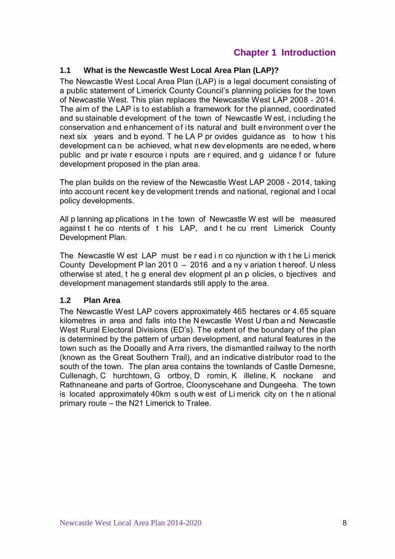
1.2 Plan Area The Newcastle West LAP covers approximately 465 hectares or 4.65 square kilometres in area and falls into t he N ewcastle West U rban a nd Newcastle West Rural Electoral Divisions (ED’s). The extent of the boundary of the plan is determined by the pattern of urban development, and natural features in the town such as the Dooally and A rra rivers, the dismantled railway to the north (known as the Great Southern Trail), and an indicative distributor road to the south of the town. The plan area contains the townlands of Castle Demesne, Cullenagh, C hurchtown, G ortboy, D romin, K illeline, K nockane and Rathnaneane and parts of Gortroe, Cloonyscehane and Dungeeha. The town is located approximately 40km s outh w est of Li merick city on t he n ational primary route – the N21 Limerick to Tralee.
Newcastle West Local Area Plan 2014-2020 9
Figure 1.1 Location of Newcastle West
Not to scale
1.3 The Review Process 1.3.1 Steps involved in preparation of the plan The review of the 2008 Local Area Plan commenced on the 12th October 2013 with t he publ ication of an i ssues paper ent itled ‘ Proposed Newcastle W est Local A rea P lan 2014 – 2020 – Issues Paper’. I ts intention was to prompt discussion on local issues at pre-draft stage. Copies of the issues paper and an i nvitation t o make a su bmission w ere se nt t o l ocal co mmunity an d voluntary agencies in the area. A public information evening was held in the Newcastle West Area Office on Tuesday 15th
October, 6pm – 8pm.
The proposed P lan w as placed o n pu blic display at C ounty B uildings, ar ea offices, public libraries and o n t he i nternet at www.lcc.ie for a pe riod o f six weeks from 25th January 2014 – 10th March 2014. Again, written submissions were invited and a second public information evening was held in the town on the 10th
February 2014. At t he en d o f t he pu blic consultation period a Manager’s Report w as prepared on i ssues arising dur ing t he publ ic consultation period and was submitted to the Members of the Council for their consideration. Following the elected member’s consideration o f t he Manager’s Report, t he C ouncil d ecided to m aterially am end t he proposed local ar ea pl an and a f urther per iod o f four weeks public consultation took place from the 24th May to 23rd June 2014 on these material alterations only. A f urther Manager’s Report o n t he submissions received regarding the proposed a mendments was then pr epared f or t he C ouncillors who having considered the report made the new local area plan, in accordance with the managers report a nd su bject t o o ne a mendment r elating t o t he z oning o f Enterprise and Employment land at Gortroe, on the 7th July 2014.

Newcastle West Local Area Plan 2014-2020 10
Responsibility for making a local area plan rests with the elected members of the Planning Authority. 1.3.2 Strategic Environmental Assessment (SEA) The EU Directive on Strategic Environmental Assessment (SEA) requires all European U nion m ember st ates to sy stematically ev aluate t he l ikely significant effects of implementing a pl an or programme prior to i ts adoption. The LAP falls within t he po pulation t hreshold for which a S trategic Environmental Assessment (SEA) is mandatory. The SEA was carried out in conjunction with this plans preparation. See Volume 2.
1.3.3 Appropriate Assessment (AA) In acco rdance w ith A rticles 6(3) and 6( 4) of t he H abitats Directive t he Planning Authority undertook an Appropriate Assessment Screening Report of the proposed plan which found that the plan would have no significant effects on Natura 2000 sites. See Volume 2. 1.3.4 Flood Risk Assessment A Stage One Flood Risk Assessment has been undertaken in support of the Newcastle W est LAP. The i nformation g athered i nformed t he Land U se Zoning Map included i n t his LAP. The LAP a dopted t he pr ecautionary approach and l ands which hav e bee n i dentified as potentially at r isk to flooding h ave bee n generally zoned f or use s which are not co nsidered vulnerable. See Volume 2.
1.4 Planning Context In accordance with the Planning and Development Acts 2000 – 2013 the LAP has been i nformed by a hi erarchy o f national, r egional, and l ocal sp atial planning policies. See Figure 1.2 below.
Figure 1.2 Hierarchy of Spatial Planning Policies
A su mmary of s ome of t he pr ovisions of r elevant g uidelines and p olicy documents are outlined below.

Newcastle West Local Area Plan 2014-2020 11
1.4.1 National Planning Context
1.4.1.1 National Spatial Strategy 2002 – 2020 The N ational S patial Strategy f or I reland ( NSS) i s a t wenty year pl anning framework designed to ach ieve a better b alance of so cial, eco nomic and physical development and population growth between regions. Its focus is on people, on places and on building communities. The National Spatial Strategy concentrates on a number o f sp ecific regions and t heir dev elopment by identifying Gateway settlements throughout the country which are to be used to su pport g eographically bal anced g rowth i n the r egions outside o f t he Greater Dublin Area. The NSS states that Newcastle West is to play a co mplementary role to the development o f the Li merick – Ennis - Shannon G ateway and t he t own i s located on important national transport corridor between the gateway and the hubs of Tralee and Killarney. 1.4.1.2 National Development Plan 2007-2013 The N ational D evelopment Plan ( NDP) i dentifies investment funding for significant pr ojects in se ctors such as health se rvices, so cial housi ng, education, roads, public transport, rural development, industry, and water and waste services. T he N DP i s designed t o st rengthen a nd i mprove t he international competitiveness of the Country so as to support continued, but more balanced, economic and social development in line with the NSS. The NSS highlights how towns such as Newcastle West need appropriate policies and actions to support their roles as drivers of development at county level.
1.4.2 Regional Planning Context
1.4.2.1 Mid West Regional Planning Guidelines 2010 - 2022 This document h as been prepared i n accordance w ith t he ov erall p olicy frameworks established by the National Spatial Strategy 2002 - 2020 and the National Development Plan 2007-2013. It sets clear objectives and targets to guide C ounty D evelopment P lans and Loc al A rea P lans within t he r egion, specifically i n relation to future population, settlement st rategy, development distribution and infrastructure investment priorities in line with the NDP 2007-2013. The Regional Planning G uidelines provide a w ider area approach to the development of County Limerick. These guidelines look at Limerick in its regional context and identifies sub-regions or ‘zones’, with the core area of the region i ncorporating t he Limerick/Shannon G ateway. Newcastle W est is located i n z one 4 i n t erms of t he se ttlement st rategy1
and t he t own i s expected t o ex perience g rowth ov er t he 2 010 – 2022 period a ccording t o these guidelines.
1 Mid West Regional Planning Authority ‘Mid West Regional Planning Guidelines 2010 – 2020’, page 113

Newcastle West Local Area Plan 2014-2020 12
1.4.2.2 Mid-West Area Strategic Plan (MWASP) 2012 - 2030 A st rategic planning, l and us e a nd t ransportation s trategy f or t he M id-West region has been pr epared and was adopted by t he el ected members of Limerick County Council in September 2012. MWASP identifies Newcastle West as having an i mportant role as a se rvice centre i n West Li merick and dr iver of g rowth i n i ts hinterland. T he t own i s considered to hav e po tential as an i mportant n ode for p ublic t ransport. MWASP states that Newcastle West should be planned to operate in tandem with Rathkeale and Abbeyfeale and i s a focal point l inking t he g reater r ural area of West Limerick to the larger urban Limerick metropolitan area.2
1.4.2.3 Retail Strategy for the Mid West Region 2010 - 2016 This strategy was prepared in 2010 on behalf of Counties Limerick and Clare and Limerick City Council. I t was incorporated i nto the county Development Plan and addresses the retail needs, opportunities and issues of the Mid-West region setting out an i ntegrated strategic framework for retail planning in the Mid West over the period to 2016. Specifically for Newcastle West this document states that its strategy is to: ‘
• Support t he i mprovement o f r etail facilities i n N ewcastle West Town Centre t hrough t he p rovisions of m odern shop u nits and a modest growth in floor space.
• Maintain its mixed role and function.’3
1.4.2.4 Joint Housing Strategy 2010 – 2017 The H ousing S trategy has be en pr epared i n acc ordance w ith P art V o f t he Planning and Development Acts 2000-2013 and covers the functional areas of Limerick County Council, Limerick City Council and Clare County Council. A cr itical obj ective o f t he H ousing S trategy i s to ensu re t he provision o f housing for the ex isting and pr ojected future populations in accordance with the principles of proper planning and sustainable development. T he housing strategy also aims to provide an eq uitable level of social housing and s ocial integration.
2 Midwest Area Strategy Plan (MWASP) 2012 – 2030, page 65-66 3 Retail Strategy for the Mid West Region 2010 – 2016, Section 6.44, page 92

Newcastle West Local Area Plan 2014-2020 13
1.4.3 County Planning Context
1.4.3.1 Limerick County Development Plan 2010 – 2016 The Limerick County Development P lan 2010-2016 is the ‘parent’ document for this Newcastle West LAP, and thus the LAP was made in accordance with the policies and objectives as set out in the County Development Plan. The Limerick County Development P lan 2010 – 2016 sets out the Council’s policy t o st eer f uture dev elopment i n t he County base d on a settlement hierarchy r eflecting s ettlement function. I t outlines population t argets and zoning requirements for settlements for the years 2016 and 2022 which must be incorporated into LAPs. The se ttlement st ructure for County Limerick which i s set ou t i n the County Development Plan designates Newcastle West as a Tier 2 settlement which is a key service centre. Newcastle West i s the l argest o f t he t wo ke y se ttlements in t he C ounty Limerick i dentified i n t he C ounty D evelopment P lan. P olicy SSP7 of t he County Development states the following: ‘It is policy of the Council to promote Newcastle West and Kilmallock as the key service centres in the West and South Limerick areas and to promote the sustainable growth of these towns to become se lf sufficient settlements and act as se rvice ce ntres for t he i nhabitants of t heir r ural hinterlands. In th is regard it is policy of the Council to ensure that sufficient land is zoned within these settlements so that they will act as the primary focus for investment in infrastructure, ho using, t ransport, e mployment, e ducation, s hopping, heal th facilities and community.’4
1.4.3.2 Limerick 2030 - An Economic and Spatial Plan for Limerick
The Limerick 2030 plan provides an economic and spatial plan for Limerick City and C ounty up to 2 030. The pl an i s st ructured ar ound t hree m ain elements. The first i s an e conomic strategy which i dentifies how Li merick needs to be posi tioned i n or der t o best t ake adv antage o f eco nomic opportunities in order to build a stronger local economy through the creation of employment and the attraction of investment. The second element is a spatial plan focused on r evitalising and r edeveloping Li merick City C entre and t he final el ement i s a m arketing pl an w hich ai ms to use Li merick’s unique an d positive attributes to change perceptions of how Limerick is viewed. 1.4.4 Other Planning Guidelines Planning Authorities are required to take account of any policies and guidelines issued by the Minister. For a comprehensive list of other policy documents taken into account in preparing this plan refer to Chapter 1 in the Limerick County Development Plan 2010 – 2016 and the Department of Environment, Community and Local G overnment gu idance documents on i ts website: http://www.environ.ie/en/DevelopmentHousing/PlanningDevelopment/Planning/PlanningGuidance/ 4 Limerick County Council Limerick County Development Plan 2010 – 2016, Chapter 3
Urban and Rural Settlement, page 3-9

Newcastle West Local Area Plan 2014-2020 14
Chapter 2 Context
2.1 Geographical Context Newcastle West is located approximately 45Km south west of Limerick city on a relatively flat plain at the foothills of the Mullaghareirks approximately 4km to the w est o f t he t own. T he A rra r iver r ises in K nockanimpuha and flows easterly t hrough N ewcastle West adjacent to t he N 21 on N orth Quay. I t continues south easterly along the R520 (known locally as the Bruff Line) and joins the R iver D eel f urther dow nstream. T he D ooally r iver r ises in Ballynabearna t o the north of t he town, and flows south easterly to j oin the River Arra upstream of the town. On the north east boundary of the town the River Daar flows, also a tributary of the River Deel. The national route, the N21 Limerick to Killareny road, traverses the town and strategic regional r oads extend n orthwards to A rdagh a nd F oynes (R521), southeast t o D romcollogher and C harleville ( R522), and e astward t o Ballingarry and Kilmallock (R520).
2.2 Historic Evolution It is most likely that Newcastle West was founded by the Geraldines. Thomas N’Apa died i n Caislen Nua O’Conaill in June 1298 and a n i nquisition o f hi s estates described four manors in Co. Limerick including Novo Castro (Begley 1906, 155)5. There is a reference to buildings outside the castle walls in 1298 which would suggest at least the nucleus of an urban settlement at this time but i t would appear t hat t his was not e nclosed. N o ev idence i s available t o support the v iew that Newcastle West was ever a w alled town. In the same 1298 document a mill and a church were mentioned (ibid., 163-4). According to Westropp (1909, 47- 48) the village was probably destroyed with the church before 1302 and the town was again destroyed in 1315 by ‘Irish felons’.6
After the defeat of the Geraldines at the end of the 16
th
Agriculture was a source of economic prosperity in Newcastle West from the 17
century the town and surrounding lands were forfeit to the crown. The Desmond Roll (1583) gives the first full account o f Newcastle West mentioning at l east two m ills, st reet names and gardens. Despite these references, however, the medieval street pattern is unknown. In 1591 the town was granted to Sir W. Courtenay and its subsequent development was heavily influenced by that family.
th
5 Begley, J. ‘The diocese of Limerick, ancient & medieval’, vol. I, Dublin. 1906, page 155
century onw ards. T he town pr ovided an i mportant se rvice t hrough i ts weekly m arkets and v arious annual fairs. The m arket i tself w as held on a raised centre section of the Square. A 1709 survey shows the Square and the modern st reet pat tern well est ablished pr esumably as a r esult o f l andlord planning. From the 1700s onwards the town began to expand into the outlying areas, ag ain mainly due t o l andlord i mprovements. A ho use co unt i n 1 750 revealed up to 190 buildings compared to circa 70 in Moland’s Survey of 1709
6 Westropp, T.J. 1909 ‘The Desmonds’ castle at Newcastle OConyll, Co. Limerick’, Journal of the Royal Society of Antiquaries of Ireland, XXXIX, 42-58 & 350-68.

Newcastle West Local Area Plan 2014-2020 15
(O’Connor 1987, 75) .7 Around 1750 the Earl o f Devon had a market house and assembly r ooms bui lt o n t he n orth si de o f t he sq uare. I n 175 2 i t i s recorded that the streets of Newcastle were dug up and remade, while in 1753 ‘in ye middle of Newcastle there’s a great square newly settled’ (ibid., 67). The Square was mostly a residential area in the 17th and 18th centuries. The River Arra was realigned and New Quay (North Quay) was formed. Lord Courtenay built the first recorded school house in Newcastle in 1720 (Cussen 1979, 3)8. He also built a church to the south of the castle in 1777. Lewis (1837, vol. II, 425) refers to the state of industry in the early 19th century, ‘There are several establishments in the t own f or dy ing woollens, also a l arge al e and be er brewery, and a g reat nu mber of s hoe a nd br ogue makers, … a bl eaching establishment i n t he i mmediate v icinity, which occu pies 8 acres and g ives work to a num ber of men’.9 Most of the standing buildings in the Square are nineteenth century in date (Cussen 1990, 42)10. St. Ita’s Hospital (1839), the Court House (1842), the Sisters of Mercy Convent (1850) and t he Protestant school (1850) were all established in the 19th century. The Newcastle Junction of the North Kerry railway was opened in 1878 (Murray & McNeill 1976, 117). 11
By the 20
Up to 1860 the r iver Beesoms flowed openly down the middle o f B ishop Street. The river was covered over during the 1860’s and the street l ine was extended (Cussen 1990, 45). Refer to figure 2.2 below.
th century development spread along arterial roads such as Station Road and Sheehan’s road and to the south at Bothar Buí and Knockane. The late 20 th
century sa w development spreading mostly on t he outskirts of the town along the Limerick to Tralee road known as the N21.
7 O’Connor, P. J. 1987 Exploring Limerick’s past, Newcastle West. 8 Cussen, R. 1979 ‘Early Schools in N ewcastle’, Journal of the Newcastle West Historical Society, 3-15. 9 Lewis, S. 1837 A topographical dictionary of Ireland, Vol II, London. 10 Cussen, R. 1990 ‘Newcastle: T he f ace of t he t own’, Journal of the Newcastle West Historical Society, 44-7. 11 Murray, K.A. & McNeill, D.B. 1976 The Great Southern & Western Railway, Dublin.

Newcastle West Local Area Plan 2014-2020 16
Figure 2.1 Map of Newcastle West, from the first Ordnance Survey edition, 1840.
Figure 2.2 Map of Newcastle West, from Ordnance Survey, 1924
Not to scale
Not to scale

Newcastle West Local Area Plan 2014-2020 17
Figure 2.3 Aerial Photo of Newcastle West, OSI, 2012
Since the adoption of the Newcastle West LAP in 2008 there have been many positive dev elopments i n t he t own desp ite t he ec onomic downturn. These opening o f the Ghaelscoil ó D oghair on S tation Road, t he expansion o f t he Brother o f Charity se rvices partly constructed on S tation Road, close t o the Desmond C omplex. T he C ouncil h as recently g ranted per mission for a substantial dev elopment i n t he t own ce ntre f or c onstruction o f primary healthcare centre in Cullen’s Field, to the east of Market Square. A mixed use development consisting of residential units and a retail unit is presently under construction on M aiden S treet by S t. V incent d e P aul. Through the Part 8 process permission has been granted for the provision of a multi-use games area in the Castle Demesne. T he recreational value o f t he Great Southern Trail as a walking and cycling route to the north of the town has seen further development since 2008. As with every town in I reland the economic downturn i s evident in the town through the slowing down of the construction of residential development, and retail/commercial v acancy i n t he t own, i n p articular al ong S outh Quay and Maiden Street. Since June 2013 the Council has introduced a retail business and incentive scheme for vacant properties in the town centre to encourage business & retail uses in Newcastle West in order to address vacancy.12
12 Refer to www.limerick.ie/.../Business%20and%20Retail%20Incentive%20Scheme
In terms of residential vacancy the 2011 census recorded 588 vacant dwellings in the town which is 19.4% of the total housing stock in the town. The national rate was 14.5% at the time. There are 4 unfinished residential estates which were identified by the DoECLG for the purposes of exemption from household
Not to scale

Newcastle West Local Area Plan 2014-2020 18
tax in Ju ly 20 13. These ar e D aar R iver Walk, D aar R iver V iew, C arrig Desmond and Arra View.
2.3 Natural and Built Environment Newcastle West is a vibrant riverside town having developed on the banks of the River Arra since the Norman t imes with the construction of the medieval complex D esmond H all. B y t he 1 9th
century the co ntinuous traditional I rish townscape o f 2 a nd 3 st orey bui ldings was well est ablished o n t he S quare where markets and fairs took place. Similarly on the streets radiating from the Square this traditional streetscape is also found and, generally these buildings remain largely intact to present day.
There ar e 69 Protected S tructures within t he LA P bou ndary and an Architectural Conservation A rea (ACA) taking i n t he S quare, Maiden S treet, North Quay and Bridge Street. Sixty three of these structures are listed in the National I nventory of A rchitectural H eritage.13
There are 20 r ecorded archaeological monuments within the LAP boundary.
Figure 2.4 Examples of Protected Structures, Newcastle West
St. Ita’s Hospital, Former workhouse Carnegie Library, Bishop Street
2.4 Function Newcastle West r etains its importance as the m ain county t own i n Limerick having the largest population in the County outside the metropolitan area of Limerick city. It has experienced consistent population growth since 1991 and this trend is expected to continue to 2022. Newcastle West i s a ke y se rvice pr ovider of r egional i mportance i n West Limerick and b eyond t he ad ministrative boun dary of Li merick County i nto 13 Refer to www.buildingsofireland.ie

Newcastle West Local Area Plan 2014-2020 19
North K erry. T he t own has a w ide r ange o f r etail, commercial, social a nd civic services in the town that serve not only the resident population but also the g reater West Limerick-North K erry area. T he t own i s the l ocation f or a number of r egional c entres for t he v arious infrastructural an d social/civic services, such as the regional headquarters for the Revenue Commissioners, the di strict hea dquarters for A n G arda S uíochana, an d r egional of fices for Eircom a nd ESB N etworks. T here i s a di strict co urt se rvice in t he t own. Limerick County Council has its administrative offices for the Newcastle West Electoral Area i n t he t own, a l ibrary and a civic recycling ce ntre on S tation Road. There i s a public hospital, known as St. I ta’s in Gortboy and a HSE community ca re ce ntre i n the t own. There ar e pr oposals for t he further development o f t he H SE facilities in the t own at C ullen’s Field off M arket Square co nsisting o f a primary healthcare ce ntre. The l ocal d evelopment company West Limerick Resources also has their headquarters in the town. Newcastle West has a wide variety of shops and professional services located in t he t own ce ntre t hat pr ovides for t he basi c needs of t he t own and surrounding catchment area. There is two large convenience retailers in the heart of the town (Garvey’s Supervalu and Dooley’s Supervalu). The discount food store Li dl i s located on S heehan’s Road an d T esco i s located on t he Limerick Road (N21). There are a number of high quality fashion boutiques in the town. The town i s also the location for substantial D IY stores, f urniture stores, pubs and restaurants. There are a number of industries located in the town. Large employers in the town include Ballygowan Natural Mineral Water/Britvic Ireland, Rettig Myson (manufacturing hea ting pr oducts), F iltertek (manufacturing m edical dev ices), PSE P ower S olutions (electrical and m echanical eng ineering) and B S Services (manufacturing ai r-conditioning syst ems). Ju st out side t he LA P boundary on t he Ardagh Road, north of the town, Pallas Foods operates i ts headquarters for its nat ionwide food d istribution s ervice. S hannon Development have a substantial business park in the town consisting of 14 sites located on Station Road and an enterprise centre on Sheehan’s Road. Newcastle West al so has a r ole as a tourism se rvice pr ovider. T ourism attractions in t he t own i nclude t he r estored m edieval co mplex kn own as Desmond Hall and the annual cultural Eigse festival. In more recent times the recreational value of the Great Southern Trail in terms of walking and cycling has been developed, with further potential to develop this amenity. T ourism accommodation i s provided i n t he t own w ith hot el acco mmodation at t he Courtney Lodge Hotel, and B&B accommodation on t he outskirts of the town on the N21.

Newcastle West Local Area Plan 2014-2020 20
2.5 Demographic and Socio-economic context 2.5.1 Population The total popul ation o f Newcastle West t own a ccording t o t he 2011 c ensus was 6327. This represented a 24.1% increase in population from the 2006 figure which was 5098. As can be seen from table 2.1 below Newcastle West has experienced consistent population growth since 1991. However, the rate of population increase was greatest during the 2006 – 2011 period.
Table 2.1 Total Population of Newcastle West town (Newcastle West Urban and Rural EDs)
Census Population
total Population change %
1991 4306 1996 4373 1.55
2002 4800 9.76 2006 5098 6.2 2011 6327 24.1
Source: CSO Census Figure 2.5 below indicates the total population trend experienced by Newcastle West town over the period 1991 to 2011 for both electoral areas in the town. Newcastle West Rural experienced a popul ation decr ease from 2006 – 2011, poss ibly due t o the Council’s settlement policy and the requirement that applicants applying for single houses demonstrate housing need, and the general downturn in the economy. Figure 2.5 Population trend experienced in Newcastle West town by ED, 1991 –
2011, CSO
0
1000
2000
3000
4000
5000
6000
7000
1991 1996 2002 2006 2011 Newcastle West Urban 3287 3228 3495 3922 4880 Newcastle West Rural 1019 1085 1305 1961 1447 Total 4306 4373 4800 5883 6327
Popu
latio
n

Newcastle West Local Area Plan 2014-2020 21
Non-Irish nat ionals accounted for 23. 5% o f the po pulation i n t he t own, with polish nationals accounting of the largest proportion, followed by Lithuanians according to the 2011 census. 2.5.2 Age profile The graph below depicts the age structure in Newcastle West town in 2011. Those under 20 y ears of ag e acc ount for 25. 25% of t he total ce nsus population for t he t own. T he l argest co hort i s the 30 – 39 y ear ag e gr oup, accounting for 19% of the total census population in the town. The 20 – 39 age g roup accounts for 35% o f t he t otal c ensus po pulation w hich pl aces demands associated with young families including future housing, educational facilities and other social facilities and services. Persons aged 60+ accounts for 17% ( 1100 people) o f t he 20 11 ce nsus population i n t he t own. T his creates demands for services supporting an ag ing population and the future development of the town must be mindful of this trend.
Figure 2.6 Age Profile, Newcastle West town, Census 2011
2.5.3 Employment Figure 2.7 below depicts the employment in the different broad sectors in the 2011 Census. The greatest numbers were employed in the commerce and trade, followed by professional services. This is a reflection of the important role of the town as a commercial and service centre of regional importance. The m anufacturing se ctor i s the t hird hi ghest e mployer i n t he t own with considerably more males employed in this sector than females.
0
200
400
600
800
1000
1200
1400
0-9 010-19 20-29 30-39 40-49 50-59 60-69 70-79 80+ Male 497 321 477 632 405 283 241 146 83 Female 454 325 569 594 375 295 244 171 215 Total 951 646 1046 1226 780 576 485 317 298
Persons

Newcastle West Local Area Plan 2014-2020 22
Figure 2.7 Persons at work by industry and sex, Newcastle West Urban and Rural EDs, Census 2011
Categories 1 Agriculture, forestry and fishing 2 Building and construction 3 Manufacturing 4 Commerce and trade 5 Transport and communications 6 Public administration 7 Professional services 8 Other Figure 2.8 indicates that the unemployment rate in N ewcastle West in 2011 as a percentage o f all those aged 15 years and over was 24%. This was above the national unemployment rate of 19%. More males than females are unemployed and more women were looking after the family/home.
Figure 2.8 Comparative trends in unemployment rates – Newcastle West town
and state according to the census
1 2 3 4 5 6 7 8 male 56 132 332 358 108 50 94 152 female 8 7 132 304 34 50 447 177 total 64 139 464 662 142 100 541 299
0
100
200
300
400
500
600
700
Pers
ons
9.9%
24.0%
8.5%
19.0%
0.0%
5.0%
10.0%
15.0%
20.0%
25.0%
30.0%
2006 2011
% u
nem
ploy
men
t rat
e
Newcastle West
State

Newcastle West Local Area Plan 2014-2020 23
Figure 2.9 Persons aged 15 years and over by principal economic status, Newcastle West, Census 2011
Category - economic status 1 Persons at work 2 Looking for first regular job 3 Unemployed having lost or given up previous job 4 Student 5 Looking after family/home 6 Retired 7 Unable to work due to illness /disability 8 Other 2.5.4 Education Analysis of the 2011 census indicates a relatively good standard of education in the town. Twenty three percent o f the population aged 15 and over have completed education to leaving cert level. Forty four percent have completed education above l eaving ce rt l evel. T his hi gh l evel of education is a considerable strength for the town.
1 2 3 4 5 6 7 8 Male 1282 35 442 168 17 337 135 6 Female 1159 26 269 201 415 402 133 13 Total 2441 61 711 369 432 739 268 19
0
500
1000
1500
2000
2500
3000 Pe
rson
s
Male
Female
Total

Newcastle West Local Area Plan 2014-2020 24
Figure 2.10 Highest level of education persons aged 15 years and over, Census 2011
2.5.5 Travel Patterns Figure 2.11 shows the travel time to work, school or college by people living in Newcastle West town. According to the 2011 census 69% of people travel less than 30 minutes on their dai ly commute which is a posi tive at tribute for the town. Figure 2.13 below shows that 48% of people travel to work, school or co llege as a car dr iver, and 2 1% commute as car passengers. E ighteen percent walk on their daily commute but only 3% avail of public transport. No one indicated in the 2011 census that they commute by bicycle.
1%
15%
17%
23%
12%
7%
5%
8%
7% 5%
0%
No formal education
Primary
Lower secondary
Upper secondary
Technical/vocational
Certificate/apprenticeship
Higher certificate
Ordinary bachelor degree
Honours bachelor degree
Postgraduate diploma/degree

Newcastle West Local Area Plan 2014-2020 25
Figure 2.11 Persons aged 5 years and over by travel time to work, school or college, Newcastle West, Census 2011
Figure 2.12 Persons aged 5 years and over by means of travel to work, school or college, Newcastle West, Census 2011.
18%
0% 3% 0% 0%
48%
21%
5%
2%
3% On foot
Bicycle
Bus/minibus/coach
Train
Motorcycle/scooter
Car driver
Car passenger
Van
Other
Not stated
<15mins 16-29mins
30-45mins
46-60mins
61-90mins 90mins+ not
stated no.of persons 1691 710 486 182 123 51 204
0
200
400
600
800
1000
1200
1400
1600
1800 N
o. o
f per
sons

Newcastle West Local Area Plan 2014-2020 26
Chapter 3 Plan Strategy
3.1 Policy Context The Newcastle West LA P 201 4 – 2020 was made i n acc ordance w ith t he objectives as set out in the Limerick County Development Plan (CDP) 2010 -2016. The CDP contains the Council’s policy to guide future development in County Limerick. This guidance includes placing settlements, towns and villages in a settlement hi erarchy det ermined by t he p opulation o f t he se ttlement, and existing publ ic and private services. T he se ttlement hierarchy reflects the development role of each settlement within the county. Newcastle West is a Tier 2 settlement providing a wide range of services for its inhabitants and the greater N ewcastle West and N orth K erry r egion. The County D evelopment Plan also outlines the population projections for Newcastle West town up to 2016 and 2022. These projections are referred to as the core strategy in the CDP14
.
3.2 Vision Statement
It is the long term vision of the Council that Newcastle West functions efficiently as a place where people can and want to live, work, visit, fostering an authentic sense of place, and is competitive in attracting future investment.
To achieve this vision Newcastle West must develop in a manner that protects its rich cu ltural and n atural her itage, accommodates a v ibrant and balanced community, and provides good e mployment op portunities and q uality l ocal services and am enities. G ood t ransport l inks are i mportant, i ncluding improvements to public transport services to provide a g enuine alternative to the ca r. Building on t he ex isting st rengths of t he settlement i t i s imperative that all stakeholders maximise any development opportunities in the town to secure progression and improved quality of life. This vision statement for the town i s guided by nat ional pol icy i n r elation t o su stainable de velopment. According to the DECLG 2012 document: ‘Sustainable communities are places where people want to live and work, are environmentally su stainable and co ntribute t o a high q uality o f l ife for residents.”15
14 Limerick County Development Plan 2010 – 2016, Chapter 2, Core Strategy and Chapter 3, Urban and Rural Settlement Strategy 15 Our Sustainable Future – A Framework for Sustainable Development for Ireland’, DECLG 2012, page 42

Newcastle West Local Area Plan 2014-2020 27
3.3 Strategic Policy
S1 Sustainable Development It is the policy of the Council to support the sustainable development of Newcastle West. S2 Compliance with the Limerick County Development Plan It is the policy of the Council to ensure all proposals shall comply with the policies, objectives and development management standards of the Limerick County Development Plan 2010 – 2016 and the objectives of this Plan. In order to achieve strategic policy S1 this LAP focuses on:
(a) Rationalising t he r esidential l and us e i n t he t own t o co mply w ith t he population targets as set ou t i n t he C ounty D evelopment P lan c ore strategy.
(b) Ensuring dev elopment acco mmodates envisaged h ousing ne ed and diversity to sustain vibrant, socially balanced communities.
(c) Ensuring t hat l and u se z ones and objectives provide f or adequate social and r ecreational f acilities, i n t andem w ith t he g rowth o f Newcastle West.
(d) Enhancement and development of the town centre. (e) Ensuring that the town develops in a way that protects and enhances
the r ichness and i ntegrity of t he town’s natural, bui lt and cultural heritage.
(f) Ensuring t hat t he g rowth of t he t own i s accompanied by adeq uate infrastructure.
3.4 Evaluation of the 2008 Newcastle West LAP It i s important t o assess the st rengths and l imitations of the 2008 – 2014 Newcastle West LAP and to determine what planning policies are relevant to the future development of the town. There hav e b een s ome si gnificant developments by t he public, pr ivate and voluntary sectors since the adoption of the 2008 LAP. Amenities have been improved i ncluding on going dev elopment o f t he G reat S outhern T rail as a walking and cycling route, and there has been ongoing development works in the Demesne including the provision of outdoor exercise equipment. Works have commenced on the provision of a soccer pitch in Killeline by Newcastle West Rovers. A Part 8 planning permission has recently been granted for the construction o f a m ulti-use g ames area i n the D emesne w hich w ill pr ovide recreational f acilities for ol der ch ildren. S t.Vincent de P aul hav e r ecently started the construction of a development in Maiden Street consisting of the demolition of vacant d ilapidated buildings and the construction o f residential units, a r etail uni t an d o ffices, al l o f w hich w ill ha ve a posi tive i mpact o n Maiden Street.

Newcastle West Local Area Plan 2014-2020 28
Figure 3.1 Buildings to be replaced and the photomontage of the redevelopment by St.Vincent de Paul on Maiden Street as submitted to the
Council In r ecent y ears, so me of t he m ajor dev elopments that h ave t aken pl ace i n Newcastle West are housing developments at Castle Demesne, Arraview, and Daar River Walk. These developments commenced pr ior to the adoption of the N ewcastle West LAP i n 2 008 b ut c onstruction has ce ased due t o t he downturn i n the eco nomy. R ockspring D evelopment Lt d. s ecured pl anning permission f or an ex tension o f time f or Castle Desmond f or completion o f dwellings, co nstruction o f a n ursing hom e, ap artments, s hops, o ffices, retirement homes and a health centre until 2015. The C ouncil g ranted per mission t o t he HSE f or t he co nstruction o f a substantial primary care centre with a retail unit and office accommodation in Cullen’s field by the Market Yard in 2010. This investment is welcomed as it is a m ulti-use dev elopment i n the t own ce ntre, b ut this has not y et commenced. There are also a number of respects in which little or no progress has been made on the objectives in the 2008 Local Area Plan.
1. There has been no development of 5 o f t he 7 o pportunity si tes identified by t he 2008 L AP as having r edevelopment pot ential. Opportunity si te 6 h as seen t he i mprovement o f t he r ecreational amenity of the Great Southern Trail as accessed from Station Road. In December 2 013 p ermission w as granted by t he C ouncil for t he construction of a discount food store on Nashes Lane. There has been some d evelopment o n B rewery Lane w ith demolition o f o utbuildings and the extension of a public house on the Square.
2. There h as been n o d evelopment o n t he 7 areas zoned for se rviced sites and r esidential dev elopment. The 2008 P lan co ntained a preliminary dev elopment brief for e ach ar ea t o r eflect t he C ouncil’s objectives for the town. T he absence of development is attributed to the down t urn i n t he co nstruction i ndustry and t he decline i n the residential property market.

Newcastle West Local Area Plan 2014-2020 29
3. There has been no development o f t he l ands zoned i ndustrial 1 (approximately 23 he ctares) in D romin to the east o f t he t own w ith access to t he N 21. The N ewcastle West Business P ark on S tation Road r emains underdeveloped, a nd t he N ewcastle West E nterprise Centre on Sheahan’s Road has a number of vacant units.
4. Retail/commercial v acancy i s a se rious issue i n t he t own with a considerable number of units vacant in the town centre. These include older premises such as those on Upper Maiden Street but also recently built uni ts. S ome v acant uni ts are focal b uildings and/or o f a s cale which is highly visible, for example, The Bridge House on Bridge Street and N orth Q uay. V acancy has a co ntagion ef fect a nd h as also exacerbated since the 2008 LAP. F or example, on South Quay there were 9 uni ts out o f 1 8 r etail/commercial pr operties located on South Quay observed to be vacant in August 2013.
Figure 3.2 Large scale vacant prominent buildings in Newcastle West
3.5 SWOT Analysis The following t able se ts out t he main st rengths, w eaknesses, op portunities and threats as identified through public consultation at the pre-draft stage and the site appraisals undertaken as part of the plan preparation process.
Table 3.1 SWOT Analysis of Newcastle West town
Strengths Weaknesses/ Challenges
Opportunities Threats
• Most populated town in the county, with population growth expected to continue • Accessible to regional and national road network • Has a number of key community and regional services
• Flood risk identified in the town • High number o f vacant commercial and residential units • Lack of employment opportunities in the town • High
• Land zoned adjacent to N21 for small and medium size employment and development activity.
• Further development of community initiatives with the experience of a strong voluntary sector
• Tourism and amenity development potential
• A number of unfinished housing developments in the town • Contagion effect of building vacancy • Employment losses associated with the downturn in the economy • Reduction in public service

Newcastle West Local Area Plan 2014-2020 30
• Has a strong history of community development and a vibrant local voluntary sector • Rich built fabric and traditional streetscape • Picturesque location on the banks of the River Arra • Relatively young and educated population • Quality open space and recreation facilities – the Demesne and Great Southern Trail
unemployment rates
• Valuable historical heritage generally intact e.g. Desmond Hall,
• traditional streetscapes • Serviced business
park located in the town
• Good quality river biodiversity
provision due to minimising costs • Uncertainty regarding the release of zoned lands
3.6 Population Targets and Zoning Requirements 3.6.1 Population Targets The co re st rategy of t he Li merick County D evelopment P lan 201 0-2016 outlines population targets for county Limerick, which were al located by t he DoECLG at national l evel and di stributed a t r egional l evel by t he M id West Regional A uthority. T he M id West R egional Planning G uidelines 2 010-2022 have al located a p opulation target of an a dditional 32,800 people for county Limerick up to the year 2022. Each settlement is allocated a specific population target in the Core Strategy of the County Development Plan16
. The amount of land to be zoned in Local Area Plans is generally based on the population targets as set out in the Core Strategy, which was prepared in advance of the 2011 Census returns. The population target for Newcastle West in the Core Strategy was an additional 4600 p ersons by 20 22 ( i.e. po pulation acc ording t o t he 2 006 c ensus w as 5098 + 4600 expected by the core strategy to 2022 = total population in 2022 of 9698). Such has been the extent of growth between 2006 - 2011 that the population of t he t own according t o t he 2011 census was 6372 w hich represents a 24% increase on the 2006 population of 5098. Refer to Section 2.5.1 of this plan.
It i s reasonable t o a ssume t hat N ewcastle West w ill gr ow b y an a mount similar to that which was allocated in the core strategy applied on a pro rata annual basis. The growth rate for Newcastle West in the core strategy was for an additional 4600 persons and an additional 2465 housing units over the 16
16 Limerick County Development Plan 2010 – 2016, Volume 1, Chapter 2 Core Strategy, Table 2.5

Newcastle West Local Area Plan 2014-2020 31
year period from 2006 to 2022. However, according to the 2011 census 394 houses have been built in the town since 2006. Therefore, an additional 2071 units are required from 2011 to 2022. The D oECLG adv ise i n i ts guidance doc ument ‘Sustainable R esidential Development in Urban Areas – Guidelines for Planning Authorities’ 2009 t he allocation of 20% of housing units as serviced sites at a density of 10 units per hectare and the remaining 80% to be applied at a density of 35 units to the hectare. H owever, given t he d ownturn i n t he economy and c urrent d emand the C ouncil co nsider the allocation o f 1 0% t o s erviced si tes and 90 % t o residential m ore appropriate f or Newcastle West at t his time. This will b e monitored over the lifetime of this plan. To calculate t he a mount o f zoned l and r equired t o accommodate g rowth t o 2020 according to the core strategy the following applies: 90% o f 16 95 ad ditional uni ts = 1526 uni ts at a densi ty of 35 u nits to t he hectare + addi tional 50% he adroom = 65 hect ares as residentially zoned lands 10% of 1695 additional units = 170 units at a density of 10 units to the hectare + additional 50% headroom = 25 hectares The total land required for serviced sites and residentially zoned land for the 2011 – 2020 period is 90 hectares.
Table 3.2 Population Target, total residential units and zoned land requirements
2006
census 2011
census Expected
growth 2011-2020
Expected growth
2020 -2022
Total population 5098 6372 2721 604 Additional units required
1695 376
Zoned land required to accommodate additional units + 50% headroom
90 ha 21 ha

Newcastle West Local Area Plan 2014-2020 32
Table 3.3 Residential units and land requirements by 2020 A
Residential development
areas
B Serviced sites
Total required by 2020 (A+B)
Additional Units required
1526 170 1696
Area required (ha)
65 25 90
3.6.2 Land Currently Available for Housing Development The t otal area o f l and z oned r esidential a nd se rviced si tes ( includes all phases) i n t he 20 08 LAP that r emain u ndeveloped i s 11 9ha. Since t he adoption of the 2008 LAP consultants were commissioned by the Council to produce flood m aps for t he co unty. Approximately 22 h ectares of t he l and which was zoned i n t he 20 08 LAP for r esidential use a nd se rviced si tes in Newcastle West is indicated as a flood zone. Taking this factor into account the Council will have to re-zone these lands to alternative uses in accordance with the DoECLG guidance issued in 2009 ‘The Planning System and Flood Risk Management – Guidance for Local A uthorities’17
. T aking i nto acco unt the flood zone identified there is 96ha of residential and serviced sites zoned land available from the 2008 LAP.
Table 3.4 outlines the amount of land in hectares that is zoned in the plan in each ph ase. A total o f 88.3 hectares are z oned as ph ase on e, w hich i s expected to meet the population target for the plan period.
Table 3.4 Residential land required and zoned
Total Required by 2020
Total Required by 2022
Zoned Phase 1
Zoned Phase 2
Residential development area - hectares
65 80 63.4 40.97
Serviced Sites- hectares
25 31 24.90 15.01
Total hectares
90 111 88.30 55.98
17 http://www.environ.ie/en/DevelopmentHousing/PlanningDevelopment/Planning/PlanningGuidance/

Newcastle West Local Area Plan 2014-2020 33
Chapter 4 Housing
Strategic Policy for Housing Policy H1 It is the policy of the Council to provide appropriately zoned lands to cater for the sustainable growth of Newcastle West town and to ensure that all residents can enjoy a safe and accessible environment. Policy H 2 It is the policy of the Council that quality shall underpin all new development by creating and maintaining a sense of place and local distinctiveness in established and new development areas.
4.1 Introduction Based on the population and household projections in Chapter 3, 90 hectares of l and z oned for r esidential use i s required t o acc ommodate t he projected population growth of 2721 by 2020. 63.4 hectares of l and has been zoned ‘Residential D evelopment – Phase 1’ in t his Plan and 40.98 hectares has been designated Residential Development – Phase 2. 24.90 hectares of land is zoned for ‘Serviced S ites – Phase 1’ which will accommodate 10 uni ts to the hectare while the ‘Residential Development Area’ zoned land is envisaged to accommodate a d ensity of 35 units to the hectare. Phase two lands will only be per mitted w hen a t l east 50% o f the ho using i n ph ase 1 has been completed. There i s, how ever, a nee d t o e nsure t hat new open sp ace an d r ecreation facilities are provided i n co njunction w ith new dev elopments on a p hased basis. Therefore, the Council will work with local community organisations to facilitate the provision of new open space within the town in conjunction with new development during the lifetime of the Plan on a phased basis. Chapter 3, P olicy SS P7 in t he C ounty D evelopment P lan outlines the Council’s requirements for dev elopment i n Newcastle West. The C ouncil’s objective under Objective SS01 is to ensure that development is in proportion to t he pat tern o f ex isting dev elopment and a s close t o the town ce ntre a s possible. It also requires that the town grows in a sequential, compact manner and avoids leap frogging of development. Within Tier 2 settlements generally no on e pr oposal for r esidential d evelopment sh all i ncrease t he ex isting housing stock by more than 15% within the lifetime of this LAP. According to the 2011 census there were 3024 houses in the town. 4.2 Residential density, design, mix and phasing Future r esidential d evelopment i s required t o be of a g ood q uality design, accommodate a mixture of house types and integrate with the existing town. To ass ess future pr oposals for r esidential development, dev elopers will be required to submit as part of the planning application, detailed design br iefs, sustainability st atement a nd s ocial i nfrastructure assessment ( SSSIA) as required by the County Development Plan.

Newcastle West Local Area Plan 2014-2020 34
Pedestrian and cycle links will be an important consideration for any proposal. Lands at Churchtown will be r equired to provide quality pedestrian and cy cle paths connecting to the Great Southern Trail, and providing future linkage to the Gaelscoil and t he t own ce ntre. S imilarly, l ands at Knockane w ill be required t o i ncorporate l inks into o pen s pace asso ciated w ith R iver M ash. Lands at Killeline will be required to link into open space and permeability will be required with ex isting residential estates. A ll l inks/pathways will facilitate the pedestrian a nd c yclist m ovement. T hese l inks w ill be finished by t he developer to a high standard, contributing to improving public realm, mobility and connections with existing facilities and residential areas where possible. Consideration sh ould be g iven i n t he d esign for l ow sp eed v ehicular t raffic (including 30 – 50km/h) where a balance is achieved between vehicular traffic and other use rs of the st reet i ncluding pe destrians, cy clists, and r esidents without co mpromising acce ss by em ergency se rvices. Egresses to op en spaces and links will be overlooked by houses in the interest of public safety. Rear bo undary w alls f acing l inks shall b e av oided. Proposals for t he development of new residential estates shall comply with objective H2 below. Objective H1: New Housing It i s an objective o f t he Council, on se rviced l and that i s zoned ‘Residential Development Area’ to: a) Facilitate r esidential d evelopment i n accordance w ith t he principles and
guidelines of t he ‘Sustainable R esidential D evelopment in Urban A reas’ (May 2009), the accompanying Urban Design Manual, ‘Quality Housing for Sustainable Communities’ (DEHLG, 2007) and the policies, objectives and Development M anagement S tandards contained i n t he Li merick C ounty Development P lan, 2 010-2016 and any su bsequent c ounty dev elopment plan.
b) Promote the provision of community and ot her facilities such as childcare as an integral part of new developments.
Objective H2: Residential density, design, mix and phasing It is an objective of the Council to: a) Ensure that proposals for residential development are planned coherently
through the use o f d esign briefs, m aster plans for l arger l andholdings where pr oposals i nvolve t he p artial d evelopment o f l andholdings if appropriate, s ustainability st atements and s ocial i nfrastructure assessments a nd any ot her s upplementary docu ments deemed necessary by the Council.
b) Promote t he co ncept of a ‘ compact district’ by enco uraging appr opriate densities in su itable l ocations and by r esisting sp oradic isolated developments.
c) Require an average gross density o f 35 units to t he hectare on ‘ New Residential’ zoned sites within the plan area.
d) Ensure that the density of housing in any one location is appropriate to the housing type.
e) Ensure a w ide range of house t ypes, sizes and tenures are provided to meet varying population requirements and needs.

Newcastle West Local Area Plan 2014-2020 35
f) Ensure compliance with the objectives of t he County Development P lan SSO1 to SSO7 inclusive.
g) Ensure development of residential land in Phase 2 can only proceed when at least 50% of all development in New Residential zoned areas Phase 1 is completed. This will be monitored throughout the plan period.
4.3 Serviced and low density sites Residential serviced sites offer an alternative to the option of un-serviced sites in t he open co untryside for t hose w ishing t o bui ld and desi gn t heir ow n houses. Their urban setting reduces the cost of servicing these sites and also means that r esidents hav e more c onvenient access t o sh ops an d o ther facilities. The sites should be large enough to offer the advantages commonly associated w ith r ural sites, n amely t he c apacity t o hav e c ontrol ov er t he design of one’s own house and to have generous private amenity space. The size of sites, their location and number are dictated by the over-riding need to keep the town compact. S erviced si tes should be no l ess than 0.1 hectare each i n si ze, but m ay be l arger d epending on t he si te co nfiguration or the house size. Objective H3: Serviced and low density sites It is an objective of the Council to: a) Promote lower densi ty serviced si tes in specified edge of town locations
zoned ‘ Residential S erviced S ites’, o f no l ess than 0.1 h ectares each. Larger si tes than t hese w ill generally be r equired f or ho uses exceeding 250 square metres or where the sites are of awkward configuration.
b) Require a m aster plan/design br ief for al l serviced and l ow densi ty sites and encourage within this, a high standard of design. The masterplan will show t he overall l ayout, i nfrastructure, se rvices and l andscaping f or t he whole of the serviced site development.
c) The development of land zoned serviced sites phase 2 can only proceed when 50% of p hase 1 se rviced si tes has been c ompleted to t he satisfaction of the Council. This will be monitored during the plan.
4.4 Infill Development The C ouncil w ill enco urage i nfill dev elopment i n t he t own centre, and t he adaptation of existing vacant and under-used buildings. Objective H4: Infill Development, Restoration and Town Renewal It is an objective of the Council to: a) Encourage living in the town centre by the promotion of residential uses
over businesses. b) Promote sensitive infill developments on sites in the town centre that are
not developed and are not required for access to backlands. c) Ensure that i n any pr oposed al terations to t he st reetscape o f t he t own
centre, adequate consideration is given to conservation, restoration and reconstruction, where it would affect the settings of protected structures, or the integrity of the eighteenth and nineteenth century streetscapes.

Newcastle West Local Area Plan 2014-2020 36
d) Consider o n t heir merits proposals for r esidential development o f r ear plots where they can be adequately accessed, and where they would not affect ex isting or pr oposed pr ivate am enities, st orage or p arking requirements. S uch proposals should i n general be par t of l arger masterplans involving contiguous plots.
e) To implement t he guidance on t he Opportunity A reas in Chapter 10 of this plan.
4.5 Unfinished Housing Developments In Newcastle West town there are 4 unfinished housing estates designated by the DoECLG for the purposes of the property tax exemption in July 2013. The County C ouncil est ablished an U nfinished Housing D evelopment T eam i n accordance w ith t he DoECLG g uidance on un finished h ousing t o d eal w ith these and other dev elopments i n t he town i n r elation t o v arious st ages of completion. This team has a number of key responsibilities including public safety works, the preparation of site resolution plans and the implementation of enforcement proceedings. Objective H5: Unfinished Housing Estates It is an objective of the Council to monitor and to encourage the completion of unfinished housing de velopments in the pl an ar ea i n accordance w ith t he Department of E nvironment, C ommunity and Loc al G overnment g uidance manual ‘Managing and Resolving Unfinished Housing Developments.’ 4.6 Social Housing The national housing policy statement was launched by the DoECLG in June 2011. This document out lines the g overnments vision for t he future o f t he housing se ctor i n I reland “ based on ch oice, f airness, equity acr oss tenures and on delivering quality outcomes for the resources invested”.
The Council seeks to provide social housing to meet the needs identified in the Jo int Housing S trategy f or t he administrative areas of Limerick City and County C ouncils and Clare C ounty C ouncil (2010-2017). A ll r elevant l ands zoned for residential development or a mix of uses including residential will be subject to the requirements of Part V of the Planning and Development Acts, 2000 to 2013 in relation t o t he provision o f social housing. The Council w ill engage in discussions with developers prior to the formal planning process to negotiate details of the operation of Part V of the Planning and Development Acts 2000 to 2013. It will ensure that there is proper balance and integration of tenures in any given area. In this regard the Council will take into account the needs and preferences for housing in this area, but will ensure there is not an over-supply of social housing in any one development area.

Newcastle West Local Area Plan 2014-2020 37
Objective H6: Social Housing and Joint Housing Strategy It is an objective of the Council in compliance with Objective HOU O2 of the County Development Plan, to a) R equire t hat dev elopers comply with P art V of t he Planning an d Development Acts, 2000 to 2013. b) Require dev elopers to provide so cial housing on al l l ands zoned for residential u se, i n a ccordance w ith t he ‘ Joint H ousing S trategy f or t he Administrative Areas of Limerick City and County Councils and Clare County Council’ and any subsequent document. Figure 4.1 Housing provided by the Council in 2010 at Sycamore Crescent
4.7 Voluntary Housing The voluntary sector has made a valuable contribution to housing in the town, providing good q uality acco mmodation at Lilac Court, i n K nockane t o t he south an d Li osán C ourt an d C hestnut G rove. T he S t. V incent d e P aul redevelopment on Maiden Street which i s under construction at p resent w ill contribute to the vitality of Maiden Street. (See figure 3.1 in previous chapter)
Figure 4.2 Accommodation provided by Cluid Housing at Liosán Court
4.8 Traveller Accommodation Limerick City a nd C ounty Council has adopted a Joint Traveller Accommodation Programme for the per iod 2014 - 2018 to meet the existing and projected n eeds of t ravellers in t he ci ty and co unty. T he provision o f Traveller A ccommodation i s a k ey el ement o f t he functions o f H ousing

Newcastle West Local Area Plan 2014-2020 38
Authorities and this programme has been p repared i n accordance with t he legislative requirements as set out in the Housing (Traveller Accommodation) Act 1998. Objective HOU O9 of the Limerick County Development Plan, 2010-2016 out lines the Council’s objective to provide housing accommodation for the T raveller Community i n accordance w ith t he Joint Traveller Accommodation Programme and any subsequent document. Objective H7: Joint Traveller Accommodation Programme It i s the obj ective o f t he C ouncil t o pr ovide ap propriate h ousing accommodation for t he T raveller Community i n acco rdance w ith t he J oint Traveller A ccommodation P rogramme 2 014 – 2018 a nd a ny s ubsequent programme formally adopted by the Council.

Newcastle West Local Area Plan 2014-2020 39
Chapter 5 Economic Development Strategic Policy for Economic Development Policy ED 1 It is the policy of the Newcastle West LAP to zone dedicated areas for economic development recognising Newcastle West as a key settlement in the County, and as an important local and regional employment and service centre in County Limerick, and the wider Midwest region, in accordance with the settlement hierarchy of the County Development Plan.
5.1 Introduction Newcastle West is considered to be a key economic regional node by the Mid-west A rea S trategic Plan (MWASP) – Planning and T ransportation S trategy 2012 – 2030. Newcastle is equated with other towns in the Mid West such as Nenagh, Thurles and R oscrea w hich ar e env isaged by M WASP t o act as engines of growth in their greater hinterlands. Newcastle W est town is a professional an d b usiness se rvice ce ntre for i ts community and g reater West Li merick area and N orth K erry. There i s a diverse range of businesses and services in the town as detailed previously in section 2.4 of this Plan. The largest sectors of employment in the town are commerce a nd t rade, and pr ofessional se rvices followed by manufacturing according to 2011 census (refer to figure 2.7 in Chapter 2). T he key sectors for t he t own ar e he althcare ( eg. F iltertech BV w hich m anufactures medical filters, P SE P ower S ystems, and N olan P roducts Ltd pr oducing w ooden joinery pr oducts) food and b everages ( eg . P allas Foods, A shgrove M eats, Ballygowan N atural M ineral Water Lt d.) and m achinery ( eg. M yson H eating Control Ltd which manufactures radiator valves). The public sector is also a considerable co ntributor t o em ployment a nd t he economy o f t he t own including t he H SE, t he R evenue C ommissioners, t he D epartment o f S ocial and Family af fairs, Teagasc, Department o f E ducation and Science t hrough the number of schools in the town, and Limerick County Council. However, the economy of the town is threatened by the downturn in the wider national a nd g lobal e conomies. The t own has suffered d ue to closures in manufacturing i ndustry i n t he w ider M idwest r egion, and t he closure o f t he local poul try pr ocessing pl ants such as Castlemahon F oods in M ahoonagh, and Kantoher Co-op in Kileedy. T he threat to the towns economy is evident through the high level o f vacancy in the town. M any retail units, both older building stock and new build are vacant in the town. Enterprise units are also vacant i n the en terprise ce ntre on S heahan’s Road, a nd i n D esmond Business Park.

Newcastle West Local Area Plan 2014-2020 40
Figure 5.1 Modern vacant units in Desmond Business Park A holistic collaborative approach to addressing the economic challenge facing Newcastle West must be taken by al l stakeholders including state agencies, the C ouncil, l ocal b usinesses and t he c ommunity. N ewcastle West sh ould avoid pinning all hopes for prosperity on at tracting very large manufacturing companies t o ‘ save’ t he t own. I t sh ould av oid un dervaluing t he other determinants of strong local economies, such as:
• Business retention and expansion, • Small business and entrepreneurial development, and • Tourism.
It is important to be mindful of the interconnectivity of the civic and community infrastructure with economic conditions that support business of all scales in a town. P rosperous town eco nomies are b uilt on a foundation o f st rong communities with a high quality environment and social supports that make a town a pl ace where business and people want to l ive and work. Newcastle West has many i nherent a dvantages for i ts local ec onomy i ncluding i ts business leadership through its Chamber of Commerce, the presence of many state agencies in t he t own, i ts strong v oluntary se ctor, its location on a national r oad, a nd i ts t ourism potential. I nvestment through partnership i n what N ewcastle West al ready has to offer m ake the town m ore marketable and attractive t o s ell w hen co mpeting for economic development an d j ob creation. The role of t his local area pl an i s to zone l ands appropriately for eco nomic development bearing in mind the projected population growth of the town to 2020 a nd beyond; N ewcastle West’s many st rengths and ch allenges; i ts location on the N21; providing for an element of choice in location in the town and to promote accessible employment opportunities.
5.2 ‘Enterprise and Employment’ Zoned Land A total of 41.7 hectares of land was zoned for Industrial 1 l ands in the 2008 Newcastle West LA P, an d 3 2.9 hec tares of l and was zoned for I ndustrial 2 use. I ndustrial 1 l ands are located to the east of the town along the N21, to the west o f the Square where Ballygowan Natural M ineral Water i s located,

Newcastle West Local Area Plan 2014-2020 41
and west of Church Street by the Demesne. The lands on the N21 have not been released for i ndustrial dev elopment and r emain i n ag ricultural use . Industrial 2 lands are located to the north of the town off Station Road and on Sheahan’s Road. The busi ness park to t he nor th o f S tation R oad i s underdeveloped despite providing infrastructural services to accommodate 13 sites. T o date only 3 businesses are operating f rom t his park. H aphazard vacant units are also observed in the Desmond Business Park and there are also vacant units to the east of Bishop Court and the Great Southern Trail off Station Road. There are vacant units in the enterprise centre off Sheahan’s Road lending to the v isual deterioration o f the area. R etail uses such as a launderette, food market, and a restaurant have encroached on units beside Sharwood Park and consequently are no longer light industrial in nature. In t his LAP t hese l ands are z oned ‘ enterprise a nd employment’ t o r eflect a more modern and less rigid designation of ‘industrial’. The Council has taken this approach to this land use in its recent reviews of LAPs and will continue this designation for c onsistency acr oss the co unty. U ses such as retail warehousing which were not permitted on industrial zoned land in the 2008 LAP will be permitted on enterprise and employment zoned land in this plan. Overall lands zoned for enterprise and employment are envisaged to facilitate such eco nomic development us es as outlined i n t he M id West R egional Planning Guidelines such as internationally traded services and ICT including software, small w orkshop t ype e nterprises, such as food, furniture or cr afts that c an us e l ocal r esources and ex ploit n iche m arkets. D evelopments at these locations should refer to the Development Management Guidelines for Industrial/Commercial D evelopment in S ection 1 0.6 o f t he Li merick County Development Plan. The form and scale of development on these sites shall be appropriate to t heir l ocation having regard t o su rrounding l and uses and scale. Small ent repreneurial st art up -business and i nnovation i s also an important consideration for t he t owns economy. The possi bility of s mall sca le employment opportunities and s tart u p busi ness incubation uni ts should be explored in the town with a view to re-use of existing buildings. Linkages of these incubation units and educational outreach services including third level distance centres should be explored.
Objective ED 1: Economic Development Proposals It i s the obj ective o f t he C ouncil t o per mit pr oposals for n ew ent erprise development or ex tensions to ex isting dev elopment i n appropriately zoned areas, where it can be clearly demonstrated that the proposal: (a) is located on appropriately zoned land; (b) is appropriate to the respective area in terms of size and the type of
employment generating development to be provided; (c) would not result in adverse transport effects; (d) would have no significant detrimental effect on the surrounding areas or on
the amenity of adjacent and nearby occupiers; and (e) can be serviced efficiently and economically.

Newcastle West Local Area Plan 2014-2020 42
Objective ED 2: Boundary Treatment It is the objective of the Council to ensure that where industrial, enterprise or distribution activities are proposed sufficient land shall be reserved around site boundaries, in bo th individual si tes and busi ness/enterprise parks to accommodate l andscaping to soften the v isual i mpact a nd reduce t he biodiversity loss of t he dev elopment t hereby i mproving the q uality of t he environment. Objective ED 3: Enterprise and employment zoned lands on the N21It is the objective o f the Council that any future appl ication(s) on t he lands on the N 21 sh all b e acc ompanied w ith an ov erall m aster plan an d include a buffer of screen planting along the boundary with the national road. A high quality desi gn o f si gnage an d entrance treatment w ill be ex pected of any proposal as the design should contribute to the approach to the town. T he Council w ould env isage t hat d evelopment of t hese l ands would serve as a ‘landmark’, reflecting ar rival i n the town and w ould contribute to a ‘ sense of place’ an d en forcing a posi tive i mage o f t he t own. A S trategic Transport Assessment w ill a lso b e r equired as part o f any pr oposed m aster pl an t o safeguard the strategic function of the national road network.
5.3 Retail and Commercial Development In 2010 a retail strategy for the Mid West Region, 2010 – 2016 was prepared on be half of co unties Li merick and C lare and Li merick City C ouncil. The Limerick County D evelopment P lan, 2 010 - 2016 incorporates t he pol icy recommendations from the Retail Strategy as they apply to County Limerick. In t urn l ocal ar ea plans must al so i ncorporate t he r ecommendations of t he retail strategy. Newcastle West is designated as a ‘major town centre’ – tier 2 and is equated in terms of importance with Ennis and Shannon. The Strategy's primary purpose is to ensure that adequate provision is made for new r etail development i n t he most appropriate l ocations an d t hat excessive provision of retail space is avoided in the county. The central key objective ar ising f rom the Retail Strategy is to support the "town centre first” approach in the context of the retail hierarchy, and to promote the vitality and viability of existing centres. In terms of Newcastle West, the strategy states that the ch allenge for t he t own i s to provide m odern r etail sp ace t o accommodate the needs of retailers without undermining the town centre. The strategy for Newcastle West stated in the document is to:
• ‘Support t he i mprovement o f r etail facilities in N ewcastle West town centre through the provision of modern shop units and a modest growth in floorspace.
• Maintain its mixed role function.’18
18 Joint Retail Strategy for the Midwest Region 2010 – 2016, page 91-92

Newcastle West Local Area Plan 2014-2020 43
Newcastle West town centre has a range of retail services that provide for the basic needs o f t he t own and g reater West Li merick area. The function of these businesses is extremely important. I n order to protect the vitality and viability of t he t own ce ntre new r etail developments, w ith t he exception of goods generally so ld i n bul k, w ill onl y be per mitted on l and which i s zoned town centre or mixed use. The enhancement of the local shopping facilities in both the convenience and comparison arena is a key ingredient in maintaining and e nhancing t he v itality of t he t own. N ewcastle West has si gnificant potential for r etail expansion by occupying existing vacant uni ts in t he t own centre. In 20 13 the C ouncil u ndertook an ass essment o f r etail uni t v acancy i n the town with a view of introducing targeted intervention consisting of an incentive scheme t o encourage occu pation of v acant uni ts t o st rengthen t he r etail function o f t he t own. T he scheme known as the ‘ Retail an d B usiness Incentive Scheme’ is currently operating. Promoting the provision of a diverse range of local shopping and commercial facilities will continue to play an important role in reinforcing the viability and vitality of the town centre, particularly along the streets that suffer most f rom vacancy. The town centre boundary is defined in the local area plan and it is policy of the plan to encourage the upgrading and expansion of existing retail outlets and the development of new outlets within the town centre. The core shopping centre boundary for the town in this LAP is slightly different to that in the 20 10 r etail st rategy f or t he M id West R egion base d on t he C ouncil observations on the ground and t he est ablished and per mitted u ses. F or example, the town centre boundary along Maiden Street has been amended, to reflect the uses and number of vacant properties along the street and also to ensure t hat t he existing t own ce ntre i s strengthened a nd consolidated t o support the long term viability of the town. In order to f ocus future r etail development i n t he t own ce ntre t his pl an ha s reduced the amount of land zoned ‘mixed use’ in the current LAP. In N ewcastle West t here ar e t wo ar eas outside t he t own ce ntre t hat h ave acquired a co mmercial/retail use . These are l ocated at Gortboy on S tation Road by Oak Park and on S heahan’s Road. I n Gortboy, there is a corner shop and delicatessen, women’s health cl inic, doc tor’s surgery and d entists surgery. T he s urgeries were hous es converted for t he s ole purpose o f commercial use. There are problems with parking and t raffic congestion a t times in t his area. O n S heahan’s Road l ands zoned for i ndustrial 2 i n t he 2008 LA P are presently used f or r etail act ivity. T here should be no further intensification of these uses due to the negative impact through the loss of the integrity of the town centre as the focus of retail and commercial activity. Any redevelopment of both areas should not undermine the town centre’s primacy as a retail/commercial centre. It is important that any redevelopment of these areas: a) Would h ave no si gnificant adverse a ffects on t he amenities o f adjacent
occupiers. b) Would not result in adverse transport impacts.

Newcastle West Local Area Plan 2014-2020 44
c) Would respect the prevailing development grain, scale and built form in the design and scale of development.
d) Would co mply w ith t he t erms of t he r etail obj ectives in t his Plan and i n particular w ould not undermine the t own ce ntre’s primacy as a r etail centre.
Objective ED 4: Retail Development It i s the obj ective of t he C ouncil t o e nhance t he v itality and v iability of Newcastle W est as a r etail se rvice ce ntre and t o i mprove t he q uantity an d quality of retail provision in the town by: (a) Emphasising the town centre area as the primary shopping location. (b) Encouraging the upgrading and expansion of existing retail outlets and the
development of new outlets within the town centre. (c) Ensuring t hat proposals with si gnificant r etail d evelopment el ements
comply w ith t he pr ovisions of t he C ounty R etail S trategy and the R etail Planning G uidelines in r eference t o si te s uitability and the sequential approach.
(d) Ensure t hat proposals at g round floor l evel w ithin t he town centre ar e generally restricted to shopping and closely related uses such as banking. Residential use may also be a ppropriate depending on t he si te l ocation. Storage use will not be permitted as the primary use in this location.
(e) Encouraging the use of upper floors in retail premises for commercial or residential use.
(f) Enhancing the physical env ironment o f the town centre as a location for shopping and business through measures aimed at improving conditions for pedestrians.
(g) Encourage t he r etention o f t raditional sh op fronts to e nhance t he streetscape. Shop front signage shall not, by reason of its scale, form or size, be v isually det rimental t o t he a ppearance a nd ch aracter of t he building or streetscape. Internally illuminated signs will not be permitted.
5.4 Mixed Use
Mixed use zoned lands are generally intended for a combination of residential, small scale retail and/commercial on the si te subject to standards regarding residential amenity, parking, t raffic safety and other planning considerations. It i s important t hat a ny r edevelopment o f these si tes should not r esult i n undermining of the town centre’s primacy as a retail centre. A way f rom the town co re m ixed use is intended t o support t he provision of neighbourhood centres providing goods and services to local residents.
5.5 Small-scale businesses in residential areas Proposals for pl anning per mission for s mall-scale busi ness from pe ople working in their own homes will be considered on the basis of the scale and nature of t he o peration. Uses which m ight neg atively i mpact on r esidential amenity su ch as the repair o f vehicles will not b e per mitted i n a r esidential area. The l evel o f c ustomers/callers will al so b e t aken i nto account. A ny proposals for sm all sc ale busi nesses in r esidential ar eas shall co mply with Section 10.6.2 of the County Development Plan.

Newcastle West Local Area Plan 2014-2020 45
Objective ED 5 Small-business in residential areas It is the objective of the Council to support small scale self employed business
operating from peoples own home provided that: a) The b usiness act ivity is subsidiary t o t he use o f t he dwelling as the
applicants principal home. b) Existing residential amenity is not negatively impacted upon in terms of
noise, parking and other relevant planning considerations. Note the conversion of houses for the sole purpose of commercial or retail use shall not be permitted, or the ‘retention’ of same due to the negative impact on existing residential amenity.
5.6 Tourism Newcastle West has potential for tourism growth with many important assets including: i ts location on the N21 Limerick to T ralee road, its rivers, it s local heritage including De smond Ha ll, t he De mesne, t he G reat Southern T rail walkway/ cycleway, and t he town’s traditional st reetscape w ith many fine traditional sh op fronts and ei ghteenth century bui ldings that r emain l argely intact on the Square. Cultural tourism is also very important the town and has been successful in attracting visitors to the annual Eigse festival in honour of the p oet M ichael H arnett. I n m ore r ecent t imes, the K nights of t he West festival has also been pr ogressing an nually and h as further de velopment potential f or the town as a tourist des tination. Newcastle West as a t ourism product has the potential for further development. The role of this plan is to support t his and e nsure t hat further d evelopment acr oss all se ctors in t he town does not negatively impact on the tourism potential of the town. Overall t his plan en courages the g rowth o f t he t ourism se ctor w hile safeguarding the local natural, the built environment and local cultural heritage for the benefit of both tourism and the local community. Objective ED 6: Tourism It is the objective of the Council to a) Enhance the tourism potential of the town including the promotion of new
tourism products in an environmentally sustainable manner in partnership with other agencies and the local community.
b) Encourage new development for t he t ourist i ndustry t o be l ocated w ithin the LAP boundary to maximise existing services.
c) Protect an d enh ance w here possi ble any bi odiversity / natural environment, bui lt a nd cu ltural her itage f eatures from unw arranted encroachment of unsuitable development.

Newcastle West Local Area Plan 2014-2020 46
Chapter 6 Transport Strategic Policy for Transport Policy T1: It is the policy of the Council to improve accessibility; reduce dependence on private car transport and encourage the use of energy efficient forms of transport and alternatives to the private car in accordance with national transport policy as set out in Smarter Travel. Policy T2: It is the policy of the Council to ensure that all proposals shall comply with the policies, objectives and development management standards of the Limerick County Development Plan, 2010 – 2016, the Design Manual for Urban Roads and Street (DoECGLG and DTTS, March 2013), and the Spatial Planning and National Road Guidelines (DoECLG and DTTS, 2013) in relation to transport and infrastructure and the objectives outlined below.
6.1 Introduction The Government’s policy ‘ Smarter Travel: A S ustainable Transport F uture’, the M id-West R egional P lanning G uidelines, t he Limerick County Development Plan 20 10 - 2022, a nd t he 30 y ear M id-West A rea S trategic Plan ( MWASP) al l point i n t he di rection of improving existing transport infrastructure a nd designing new i nfrastructure t hat w ill m ake no n-car transport modes more attractive. At a na tional l evel, ‘Smarter Travel’ has as a t arget t hat by 2020 t he percentage of those travelling to work by car will decrease from 65% to 45%. It recommends a range of act ions, m any t o be i mplemented t hrough t he National Development Plan. This is a particular challenge in Newcastle West where, as noted in Chapter 2 of this Plan, a significant number of commuters travel daily by car. Newcastle West is served by the N21 Limerick to Tralee a national route on the northern bank of the River Arra. A strategic regional road serves the town known as the R512 northwards to Foynes, and regional roads to the south of the t own co nnect N ewcastle West t o Kilmallock (R520) a nd Charleville (R522). T he 2008 LAP indicated a di stributor road to the south of the town. This road has not been constructed. Bus Eireann r uns r egular dai ly se rvices on t he N 21 se rvicing Li merick and Tralee. R ural B us also oper ate from N ewcastle West t o t he g eneral West Limerick hinterland. Rail t ransport ceased in the town in the 1960s and the disused railway l ine i s now used as a walkway and cy cleway known as the Great Southern Trail. There are public and private car parking areas within Newcastle West. Public parking i s available on M arket S quare and al so o ff C hurch Street w ith pedestrian acc ess through B ridewell Lane. O n-street ca r p arking i s also available on the Square.

Newcastle West Local Area Plan 2014-2020 47
Under t he A ctive T ravel T owns Initiative as part o f S marter T ravel t he Newcastle West Walking and Cycling Strategy was prepared by the Council in 2013. The principal objective of Active Travel Towns programme is to achieve modal shift from car to either walking and/or cycling in towns. The objective of the strategy commissioned by the Council was to make recommendations and suggest m easures to i ncrease t he p ublic's awareness of t he be nefits of walking and cy cling as a v iable m ode o f t ransport around t he t own. I t recommends a n umber o f engineering i nterventions including g reenways along t he R iver A rra, be tween t he G reat S outhern Trail a nd S ycamore Crescent, a nd between t he C ork Road a nd t he N 21. S oft m easures to address modal shift such as promoting sustainable travel in the town are also included.19
According to the 2011 census 69% of people living in the town travel less than 30 minutes on their daily commute and 48% of people travel to work, school or co llege as a car dr iver, and 2 1% commute as car passengers. E ighteen percent walk on their daily commute but only 3% avail of public transport. No one i ndicated t hat t hey co mmute by bi cycle. T his plan, i n t he i nterest of sustainable development o f t he t own, su pports the principle o f modal sh ift away from the private ca r t o w alking and cy cling f or j ourneys in t he t own, through a ppropriate l and us e z oning, an d p romoting a co mpact s ettlement with a co mplementary r ange o f l and uses throughout t he t own which ar e easily accessible by walking, cycling and the car. Taking a holistic approach, increasing the use of sustainable t ransport modes would improve the quality of l ife a nd w ould be nefit t he t own as a d esirable pl ace t o l ive and w ork contributing to the economic prosperity of the town as a settlement of regional importance.
6.2 Movement and accessibility The Council is committed to the development of a network of access routes reflecting t he r equirements of per sonal sa fety, ch oice, and co nvenience t o services and am enities. T he access network should facilitate access for al l, and s hould b e so cially i nclusive. T hese r equirements and t he desi re t o minimise dependence on the car for short journeys, means that a matrix type network is preferable to a network with long cul-de-sacs. Future development proposals for residential development should demonstrate compact walkable /cyclable co mmunities and nei ghbourhoods w ith t he sh ortest l inkages to community f acilities, open s pace and t he t own ce ntre making w alking and cycling m ore at tractive f or l ocal t rips. A t t he desi gn st age co nsideration should be g iven t o t he nat ional g uidance d ocuments including Sustainable Residential Development in Urban Areas – Guidelines for Planning Authorities DECLG ( 2009); National C ycle P olicy F ramework 2009-2020 a s part o f Smarter T ransport – A S ustainable T ransport F uture D TTS ( 2009); and Design M anual for U rban R oads and S treets, D TTS and D oECLG, M arch 2013; and Spatial P lanning a nd N ational R oad G uidelines, D oECLG and DTTS. These should be submitted in the design brief as part of the planning application process. Any proposals on the indicative distributor road should
19 Refer to www.lcc.ie/.../WalkingandCyclingStrategyforNewcastlewestRevD080113

Newcastle West Local Area Plan 2014-2020 48
ensure that the frontage of buildings address the road as ‘frontage-free’ roads can result in a hostile environment for both pedestrian and cyclist. In acc ordance w ith n ational r oad policy di rect acc ess or i ntensification o f direct accesses onto the N21 where the 100kpm speed limit applies shall not be permitted in accordance with the provisions of Section 2.5 of the Spatial Planning and National Roads Guidelines 2012 and Policy IN P 9 of the County Development Plan 2010 – 2016. The progression of the development of the M21 has been identified by the Mid West A rea S trategic Plan 2012 – 2030 as bei ng fundemental t o the f uture development o f the r egion. I n t he a bsence o f alignment upg rades consideration is stated to be given to a local bypass for Newcastle West.20
Objective T1: Network of pedestrian and cycle facilities It i s an obj ective of t he Council t o encourage w alking and cy cling as more convenient, p opular and sa fe m ethods of movement in Newcastle W est through supporting the recommendations of the Walking and Cycling Strategy for Newcastle West(2013).
Objective T2: Measures in support of public transport (a) It i s an obj ective o f t he C ouncil t o facilitate measures to improve public transport i nfrastructure w ithin Newcastle W est and networks to adj acent settlements and Limerick City. (b) All future development proposals shall incorporate the relevant objectives of t he M id-West Area S trategic Plan ( MWASP 20 12-2030), Walking a nd Cycling Strategy for Newcastle West (2013), and the promotion of enhanced public transport facilities and services. Objective T3: Car parking and traffic management It is an objective of the Council to encourage the provision of off-street public parking areas as part of any application for development. Objective T4: Safeguard of the capacity of the R521 Limerick – Foynes Road and the N21 Limerick – Killarney Road It is the objective of the Council to safeguard the capacity of the R521 and the N21 a nd ensure t hat any future d evelopments do n ot compromise t he strategic functions of these roads in accordance with the Spatial Planning and National Road Guidelines, 2013 by the DoECLG and DTTS. Objective T5: Development of Enterprise and Employment land adjoining the N21 It is the objective of the Council that any future development proposal for the lands zoned for E nterprise and E mployment sh all i nclude a Traffic and Transport A ssessment i n acco rdance w ith O bjective I N O 2: T raffic and Transport Assessments of the County Development Plan, to ensure that the local r oad net work and ass ociated j unctions with t he r egional road h ave
20 Midwest Regional Authority Mid West Area Strategic Plan 2012 – 2030, page 19

Newcastle West Local Area Plan 2014-2020 49
sufficient ca pacity t o facilitate t he ex tent of t he d evelopment pl anned. Furthermore, the costs of implementing mitigation measures arising f rom the traffic impact shall be borne by the developer. Objective T6: Southern Distributor Road It is the objective of the Council to;
a) promote the delivery of a southern distributor road to allow for improved accessibility and a m ore ef ficient local road network. T he phasing of zoned lands adjoining the indicative road will be co ncurrent with the construction of the road.
b) Any proposals on the indicative distributor road should ensure that the frontage o f b uildings address the r oad as ‘frontage-free’ r oads to pr event hostile environment for both pedestrian and cyclist in terms of safety.

Newcastle West Local Area Plan 2014-2020 50
Chapter 7 Infrastructure Water services, energy, telecommunications and waste Strategic policy for Infrastructure Policy IN 1 It is the policy of the Council in co-operation with Irish Water to provide for adequate water, and sewerage facilities in Newcastle West; and in general to raise awareness of energy efficiency, and waste management in the town, including the prevention, minimisation, re-use, recycling/recovery of waste. 7.1 Introduction A ke y co nsideration for t he dev elopment o f t he t own i s the av ailability and quality of infrastructure. I nfrastructure and land use should be managed and developed t ogether w hile pr otecting t he en vironment for f uture gener ations. The r esponsibility f or w ater se rvices provision from Ja nuary 1 st
7.2 Water Supply
, 2 014 i s transferred to t he newly formed semi-state body ‘ Irish Water.’ However, the local Authority will remain closely involved in the sector acting as an agent of Irish Water in relation to the operation and maintenance of water services in the town.
Newcastle West w ater su pply i s served by Tobergal w ell and C astlemahon water t reatment pl ant. T here i s sufficient r esource available t o supply t he existing needs and predicted needs of the area. Objective IN 1 Water supply and storage It is an objective of the Council to: (a) Facilitate any improvements required to the existing water supply system
to cater for the needs of an expanding population. (b) Ensure that development proposals provide adequate water infrastructure
to f acilitate proposed developments and the Newcastle West Local Area Plan.
7.3 Foul Sewerage The N ewcastle West Waste W ater Treatment P lant (WWTP) is located outside t he LA P bo undary on t he R 520 at C loonyschrene. It w as commissioned in 1984 w ith desi gn ca pacity of 90 00PE. The s ewerage network is predominately a combined se wer w ith ef fluent flowing by g ravity into the WWTP and a single outfall into River Deel. Newcastle W est W WTP a nd co llection n etwork is on t he Water S ervices Investment P rogramme and c onsultants have r ecently been ap pointed t o prepare a pr eliminary report to recommend improvements and extensions to the existing Newcastle West Sewerage Scheme.

Newcastle West Local Area Plan 2014-2020 51
Objective IN 2: Sewerage facilities It is the objective of the Council to: (a) Ensure t hat ad equate and a ppropriate w aste w ater i nfrastructure i s
provided for prior to further development to avoid any deterioration in the receiving waters. I n this regard acc ount s hall al so be t aken of existing outstanding permissions in assessing impact.
(b) Ensure that dev elopment pr oposals provide ad equate w aste w ater infrastructure to f acilitate t he proposed dev elopment. T his includes the separation o f foul a nd su rface w ater t hrough t he pr ovision o f se parate sewerage networks.
(c) Ensure t hat discharge m eets t he r equirements of t he Water F ramework Directive
7.4 Surface Water Drainage A combined system is in place for foul and storm water within the town. This has implications for the capacity of the existing sewerage network, particularly during per iods of hi gh r ainfall w here ov erflow of unt reated w astewater i nto waterways can occu r when st orm water do minates the sy stem. Within th e Churchtown ar ea t he dev elopment of t he surface w ater se wer will f orm a critical part of any proposed development. Objective IN 3: Surface water disposal It is the objective of the Council to: (a) Require that all applications for development demonstrate that appropriate
Sustainable U rban D rainage S ystems (SuDS) ar e ex amined a nd w here feasible provided.
(b) Require the submission of surface water design ca lculations establishing the suitability of drainage between the site and a suitable outfall in order to establish w hether t he ex isting su rface water dr ainage system can accommodate an a dditional discharge generated by a pr oposed development(s).
(c) Require appl icants to investigate the potential for the provision of porous surfaces where car parking and hard landscaping is proposed.
(d) Protect t he su rface w ater r esources of t he pl an ar ea, and i n i ndividual planning applications request the provision of sediment and grease traps, and pollution control measures were deemed necessary.
(e) Surface water runoff to be designed to agricultural runoff rates, subject to agreement with the local authority.
7.5 Flood Risk Management Newcastle West l ies on the downstream reach of the River Arra, which is a tributary of the R iver Deel. The three r ivers in t he c atchment t hat m eet i n Newcastle West ar e t he A rra, D oally and t he M ash. The catchment i s relatively sm all, at 43 square km, an d relatively steep i n i ts upper r eaches (Barnagh and Sugar Hill). It is highly dentritic (branched with many streams).
Newcastle West Local Area Plan 2014-2020 52
The ground f alls from over 350 mAOD to a round 80 or 90 m AOD f rom t he summit to the foot of the hills lying on t he western margins of the catchment. The g round t hen sl opes more g ently t o Newcastle West, w hich i s at an elevation of ar ound 4 5 m AOD. The u nderlying geology of t he ca tchment i s fairly impermeable primarily consisting o f l imestones and mudstones, and is overlain by poorly draining soils which are generally g leys and peat . T hese characteristics and the severity of the rainfall event on July 31 a nd August 1 2008 contributed to the extensive flooding in the town at that time.21
The C ouncil i s committed t o managing f lood r isk in acco rdance w ith t he principles set out in Government guidance ‘The P lanning System and F lood Risk Management’ (DEHLG and OPW, Nov. 2009). A stage 1 flood risk assessment has been prepared for Newcastle West and is included as appendix 2 o f t his LAP. O PW pr eliminary f lood r isk indicative maps ar e available f or Newcastle West under t he O PW’s CFRAM st udy. Finalised m aps from the O PW C FRAM st udy ar e ex pected t o be m ade available in 2014. The LA P desi gnates any l and l ocated i n t he flood z one as open sp ace o r agricultural use . H owever when t he final O PW C FRAM map for N ewcastle West is available the local area plan shall be amended if there are significant discrepancies between the OPW preliminary flood risk indicative map and the final version. Objective IN 4: Flood Risk Management It is an objective of the Council to: a) Implement t he r ecommendations of t he D epartment o f t he Environment,
Heritage and Local Government and the Office of Public Works Guidelines on ‘ The P lanning S ystem an d F lood R isk Management G uidance Documents (November 2009)‘, and any subsequent guidelines.
b) Require any development proposal in a location identified as being subject to flooding to:
1. Carry out a flood r isk / ca tchment a nalysis for t he development t o assess the l ikely l evel of flood h azard t hat may af fect t he si te t o t he satisfaction of the Council;
2. Design t he dev elopment t o av oid flood l evels, i ncorporating bui lding design m easures and m aterials to assist ev acuation and m inimise damage to property from flood waters;
3. Demonstrate t hat t he pr oposal w ill not r esult i n i ncreased r isk o f flooding el sewhere, r estrict flow acr oss floodplains, w here compensatory st orage / st orm w ater r etention measures shall be provided on site and will not alter the hydrological regime up stream or
21 Newcastle West Flood Severity and Impact Report, prepared by JBA Consulting, August 2008 on behalf of Limerick County Council, available on www.lcc.ie/waterservices

Newcastle West Local Area Plan 2014-2020 53
down stream or at the development location so as to pose an additional flood risk or to increase flood risk;
4. Proposals should have pr ovision t o r educe t he r ate a nd q uantity o f runoff i.e. minimisation of concrete surfaces and use of semi permeable materials and include adequate measures to cope with the flood r isk, e.g. sustainable drainage systems.
c) Implement t he P lanning and F lood R isk Management G uidelines for Planning A uthorities ( 2009) i n the desi gn and co nsideration of development proposals; and
d) Preserve r iparian st rips free o f dev elopment and e nsure adequate width to permit access for river maintenance.
All f lood r isk assessments should h ave r egard t o n ational flood h azard mapping, predicted changes in flood events resulting from climate change and the R iver S hannon C atchment F lood R isk and M anagement P lan S tudies (CFRAM) when completed by the OPW and the Shannon International River Basin M anagement P lan. The ‘ development m anagement j ustification t est’ and the ‘plan - making justification test’ as detailed in The P lanning System and F lood R isk Guidance docu ment w ill g uide C ouncil r esponses to development proposals in areas at moderate or high risk of flooding.
7.6 Waste Management Limerick County Council in co llaboration with ot her l ocal aut horities is preparing a Draft Southern Regional Waste Management Plan for the 2014 – 2020 period. T he f inalised waste management pl an is expected to be adopted l ate 2014. This de termines the policies and obj ectives for w aste management in the region. In Newcastle West there is a civic waste recycling facility located on Station Road providing facilities for the disposal of a comprehensive range of waste materials. Objective IN 5: Promotion of waste recycling It i s an o bjective o f t he C ouncil promote a nd support the dev elopment o f waste management and recycling in Newcastle West. Objective IN 6: Provision of composting facilities It i s an obj ective of t he C ouncil t o ensu re d evelopers provide new housi ng with effective composting facilities by applying suitable planning conditions to new residential development. Objective IN 7: Shared bin spaces It i s an obj ective o f t he C ouncil t o r equire al l co mmercial an d residential developments to be p rovided with adeq uate i nternal and ex ternal sp ace for the c orrect storage o f waste and recyclable m aterials. T his is par ticularly important i n r elation t o s hared bin sp aces such as apar tment developments. In such cases the following must be provided for:

Newcastle West Local Area Plan 2014-2020 54
(a) Adequate space must be g iven for waste to be se gregated and stored in an appropriate manner.
(b) A multi-occupancy development will require a designated, ventilated waste storage area of sufficient size which allows for the segregation of waste.
(c) New and r edesigned co mmercial bui ldings and ap artment co mplexes should hav e waste f acilities designed i n a m anner t hat w aste ca n be collected di rectly f rom t hem an d w here possi ble w aste and r ecyclables should not have t o be co llected on t he street or a t t he front o f t he premises.
7.7 Energy and Electricity Newcastle West is served by the ESB distribution network and the town itself is served by 110K V ov erhead el ectricity l ines. The Co uncil w ill w ork with Limerick-Clare Energy Agency to improve energy conservation and renewable energy use.
7.8 Access to Broadband and Telecommunications The t own o f N ewcastle West benefits from acc ess to B roadband. I t i s important t hat adequate br oadband s ervice i nfrastructure i s installed at the appropriate time into new development schemes. Objective IN 8: Broadband It is the objective of the Council to ensure that all new development proposals where r elevant, i ncorporate br oadband se rvice infrastructure on an op en access basis. The Planning Authority’s goal is to achieve a balance between facilitating the provision of mobile telecommunications services in the interests of social and economic progress and sustaining residential amenities, environmental quality and public health. When considering proposals for telecommunication masts, antennae and ancillary equipment, the Council will have regard to the DEHLG document ‘ Telecommunications Antennae and S upport S tructures’ ( DEHLG 1998) and any subsequent advisory document issued by the DECLG.

Newcastle West Local Area Plan 2014-2020 55
Chapter 8 Environment and Heritage Strategic policy for Environment and Heritage Policy EH 1 It is the policy of the Council to ensure that the archaeological, architectural, natural and built heritage of Newcastle West is protected in the interest of sustainable development. Policy EH 2 It is the policy of the Council to ensure that all proposals shall comply with the policies, objectives and development management standards of the Limerick County Development Plan 2010-2016.
8.1 Introduction The protection of the built, historic and natural environment is a keystone to the su stainable d evelopment of t he t own. C onservation an d pr eservation relates to buildings and land and the Council is concerned with the protection and enhancement of both. Economic prosperity depends on maintaining and enhancing t he e nvironment i ncluding our bui lding and n atural capital. As settlements develop t he d emands on t he environment, both na tural a nd manmade, become greater. The role of the Council is to balance the two – preservation and/or conservation of a high quality environment while satisfying modern economic and social needs. Current government policy in relation to sustainable development as set out in ‘Our Sustainable Future – A Framework for S ustainable D evelopment for I reland’, DoECLG, 20 12 st ates t hat l ocal authorities have a k ey role to play in sustainable development through their land us e an d d evelopment st rategies and t he management o f t he environment. National g uidance f or co nservation o f t he bui lt env ironment i s set out i n t he ‘ Architectural H eritage P rotection – Guidelines for Planning Authorities’, 2011 by the Department of Arts, Heritage and the Gaeltacht.
8.2 Built Environment
8.2.1 Protected Structures In the interests of safeguarding the cultural and built heritage, 67 structures throughout t he t own hav e been i dentified f or t heir co ntribution t o t he architectural her itage i n the town and hav e been designated as ‘protected structures’ und er se ction 51 o f t he P lanning and D evelopment A cts 2000 - 2013. These structures are included within the Record of Protected Structures (R.P.S.) set out in Appendix 2 of this Plan. This list of structures is an abstract from t he R ecord of Protected S tructures, which i s a st atutory docu ment maintained by Li merick County Co uncil as part o f the C ounty D evelopment Plan. As the Planning Act allows a Planning Authority to make additions to or deletions from the RPS the most recent edi tion of the RPS contained in the County D evelopment P lan sh ould be co nsulted. Exempted development regulations are not appl icable to su ch s tructures where pr oposed development w ould materially af fect t he c haracter of t he st ructure or any element of the structure which contributes to the architectural heritage. Within

Newcastle West Local Area Plan 2014-2020 56
the t own there ar e 6 3 structures on t he N ational I nventory of A rchitectural Heritage listed by the Department of Arts, Heritage and the Gaeltacht.22
Grants to ensure t he restoration an d co nservation of these b uildings in an appropriate manner reflecting the original detailing and co nstruction methods are available through the ‘Built Heritage , Jobs Leverage Scheme, 2014’ from the Department o f A rts, Heritage and the G aeltacht. Information o n a ny funding av ailable ca n be r eceived from t he C onservation O fficer, Li merick County Council.
8.2.2 Architectural Conservation Areas (ACA)
An Architectural Conservation Area (ACA) is a place, area, group of structures or t ownscape t hat i s co nsidered t o be o f sp ecial ar chitectural, hi storical, archaeological, t echnical, so cial, c ultural, or sci entific, i nterest, or t hat contributes to the appreciation of a Protected S tructure. Buildings falling within the boundaries of an A CA can be b oth protected st ructures and no n-protected st ructures. The A CA i n N ewcastle West i s located a round t he Square, Bridge Street, part of Maiden Street and on North Quay as defined in the Protected Structures and ACA Map 3 i n Appendix 1. The designation of the ACA does not preclude future development, but the carrying out of works to t he exterior of st ructures within t he A CA sh all not b e co nsidered a s exempted dev elopment w here t hose w orks would m aterially a ffect the character of t he A CA. I n assessing development pr oposals within t he ACA, the C ouncil s hall t ake i nto acc ount t he material a ffect t hat the pr oposed development would be likely to have on the character of the ACA.23
The benefits of designation of ACAs in towns include: a) Providing a focus for civic pride in the history and architectural heritage
of Newcastle West; b) Create a framework for t he pr otection o f the t own’s heritage a nd
provides guidance for property owners and developers to ensure that future change respects the character of the Area; and
c) Instill a se nse of c onfidence a nd aw areness a mong property ow ners and gives an opportunity to bui ld upon t he distinctive character of the town with potential for marketing the town as a tourism product.
8.2.3 Newcastle West Architectural Conservation Area (ACA) The collective arrangement of buildings on the Square and the st reetscapes on Bridge Street, Maiden Street and along North Quay is particularly visually impressive w ith their t raditional t erraced buildings of 2 and 3 st oreys, remaining l argely i ntact t o t he present day. P lots ar e g enerally n arrow with direct front acc ess from t he b uilding onto t he st reet. D istinctive f eatures include classical proportions of w indows and doors, natural sl ate roofs, and
22 www.buildingsofireland.ie 23 Refer to section 7.6.4, Chapter 7 of the Limerick County Development Plan

Newcastle West Local Area Plan 2014-2020 57
unrendered walls constructed of rubble with openings framed with cut stone or brick. Commercial buildings, such as the bank branches, were constructed of ashlar with tight fitting joints between the masonry units.
Figure 8.1 Part of the ACA on North Quay and The Square
New developments proposed within the Architectural Conservation Area, and in its setting, should respect the existing building lines and the historic form of those buildings. Proposals for new buildings should not seek to dominate the historic core a nd sh ould r espect t he hi storic fabric of t he buildings and t he morphology of their plots. 8.2.4 General guidance for undertaking works on older buildings To ensure that works undertaken on older traditional buildings, it is important that these works do not damage the special qualities of the bui lding i tself or the t raditional st reetscape. Many of these buildings have been in existence for g enerations and t he c ommunity has a r esponsibility t o p ass on t hese buildings as part of Newcastle West’s history and heritage. When carrying out maintenance or repair works consider the following:
• Use experts in the area of conservation. It is recommended to engage the s ervices of accr edited pr ofessionals such as the c onservation architects accredited by t he R oyal I nstitute o f A rchitects of I reland. Similarly, t he S ociety of C hartered S urveyors has a r egister o f conservation surveyors.
• Do your research, establish and understand reasons for the building or the feature of the building not being f it for purpose before undertaking the works.
• Ensure that the appropriate materials and methods are used during the works and pay attention to detail.
• Record all repairs works for the benefit of future owners. • Do as little work to the building as is possible to maintain the historical
integrity of the building. • Avoid looking at problems in isolation, no matter how minor they seem.
Consider problems in t he co ntext o f t he building as a w hole and adjoining buildings on the streetscape.
• Be careful when sourcing materials through architectural salvage. B e sure that your materials are from reliable sources and have not been taken at the expense of other buildings through theft.

Newcastle West Local Area Plan 2014-2020 58
In undertaking repairs or maintenance works to buildings in the Newcastle West Architectural Conservation A reas, pr operty ow ners and t heir contractors should b e aw are of t he materials traditionally use d in t he county, and more s pecifically, i n t he t own i tself and i ts immediate surrounds.
Works in Conservation Areas must retain existing surviving elements, aim to re-instate l ost el ements or ch aracter, w ith new bui ld co mplementing t he original streetscapes, building l ines and open areas. Where original or early surviving el ements, s uch as windows and doors, r ainwater g oods of r olled mild steel or cast iron (or a combination of both), natural slate roofing and lime renders, and so forth, t hen t hese s hould be r epaired se nsitively. T he guidance her e i s to “ do as much as necessary, as little as possible”. I f replacement proves necessary, then they must be replaced on a “like-for-like” basis. In replacing elements that were installed as replacements in recent decades, such as aluminium w indows or sm ooth finish ar tificial sl ate, there ar e g ood reasons, apart from those put forward on the basis of architectural heritage, to return t o t he or iginal materials, su ch as timber w indows and n atural sl ate. These r easons i nclude t he co mpatibility of t raditional m aterials w ith on e another and the fact that the historic material al lows the bui lding to breathe, thereby pr oviding a he althier i nternal a tmosphere for t hose usi ng t he buildings. It i s critical that interventions made retain original or ear ly surviving material and f abric. T hese a re l imited r esources that are v irtually i mpossible to replace. Q uite o ften, new m aterial ( though acce ptable) i s of a distinctively different character and if it proves necessary to take this route, then it should be positioned in as discrete a l ocation as possible, with the original material placed in the most visible spots. Historic building materials, and the techniques used to assemble them, meant that t he st ructures erected are por ous. They hav e an abi lity t o br eathe, shedding accumulated m oisture from w ithin t he building an d from its fabric. Any proposals to replace the renders should recognise this and ensure that new pl asters, w hether i nternal or ex ternal, ar e m ixed use d t he co rrect proportions of sharp sands, aggregates and building l ime. S imilar measures should be adopted when replacing failing pointing.
The use of any paints or other materials of modern composition, which seal the su rfaces to w hich t hey ar e appl ied, sh ould b e avoided as they hav e a deleterious impact on lime based materials, whether used in renders or other finishes. The use of garish colours on walls or details of structures (such as quoins), which clash with the traditional range of pigments must be avoided as they impact negatively on the cohesiveness of the streetscape. If individuality is sought, it can be imparted to a building through highlighting the timberwork of doors and their frames, windows and gates - features which are recessed

Newcastle West Local Area Plan 2014-2020 59
slightly and out of di rect v iew of t hose l ooking al ong t he l ength o f t he conservation area. Joinery and i ronmongery sh ould al so be p ainted w ith br eathable finishes. Micro-porous paints do not dry to a hi gh-gloss but have a ski n which al lows any moisture that may penetrate through to the material below to evaporate, thereby preventing it from causing serious damage through decay or rusting. Internal works, such as insulation, should ensure that the materials se lected are co mpatible w ith t he hi storic materials from w hich t he bui lding is constructed. Double glazing as replacement for original windows is generally not acceptable. H owever, ot her i nterventions, such as the reinstatement o f roller bl inds and t he i nstallation o f s econdary gl azing with polycarbonate panels held i n pl ace w ith m agnetic mounts, ca n ach ieve si gnificant improvements at a significantly lower cost than the wholesale replacement of historic windows. Other works, such as the improvements/replacement of electrical supply and distribution systems, mechanical se rvices, heat ing systems, equipment such as air conditioning units, may have implications for the external appearance of buildings within t he A CAs, and t he pl ots on which t hey st and. C ompliance with ot her r egulatory bodi es, su ch as the Fire D epartment, may al so r aise issues. C onsequently, i nterventions which m ay i mpact on ex isting f abric, places and sp aces should be ca refully pl anned. C onsultations should b e undertaken a t t he earliest op portunity w ith t he planning aut hority t o e nsure that the character and ambience of the Areas are not harmed. Objective EH 1: Architectural Conservation Area (ACA) It is the objective of the Council to protect, conserve and where appropriate, enhance the ACA as identified in Map 3. Proposals for development within the ACA shall; a) Reflect and r espect the sc ale and form of ex isting st ructures within t he
ACA in pr oportioning, ov erall sca le and use o f materials and finishes, particularly with reference to the street frontages and seek to contribute to or enhance the character and streetscape of the ACA;
b) Seek t o r etain/incorporate/replicate exterior f eatures which co ntribute or enhance the character and st reetscape of the ACA such as shop fronts, sash windows, gutters and down pipes, decorative plasterwork etc;
c) Ensure priority i s given t o t he pedestrian, t o i nclusive acce ss, an d t o facilitating the improvement of the quality of the public realm: the latter will include for consideration of the planting of t rees in the wider publ ic open spaces, benches for sitting and the articulation of uses through appropriate paving.
Objective EH 2: Protected Structures It is the objective of the Council to protect structures entered onto the Record of pr otected s tructures, or l isted t o b e en tered o nto t he R ecord and to encourage their appropriate re-use and restoration. The Council shall resist; a) Demolition of protected structures, in whole or in part;

Newcastle West Local Area Plan 2014-2020 60
b) Removal or modification of features of architectural importance; c) Development t hat w ould adv ersely af fect t he se tting of t he protected
structure.
8.3 Archaeological Heritage The core of the town of Newcastle West, situated in the townlands of Castle Demesne, Churchtown, Gortboy, Rathnaneane and Knockane, is a Recorded Monument, LI 036-067001, cl assified as a historic town. T here are twenty Recorded Monuments contained within the LAP area. There are eleven r ing forts in the immediate environs of the town. There is also a medieval church and g raveyard ( LI036-024001/002) n orth o f t he t own i n t he t ownland o f Churchtown. For further details refer to Appendix 3. The location of each archaeological monument is provided in the Record of Monuments and P laces which i s maintained a nd up-dated b y t he Archaeological S urvey of I reland, a br anch o f t he N ational Monuments Service. T he 19 94 a mendment t o t he N ational M onuments Act established the Record of Monument and Places on a statutory basis with a se t of maps and a c atalogue of si tes. Copies are available for public consultation in the Council’s Planning D epartment an d i n al l the co unty l ibraries. U nder t he provisions of the National Monuments Act Section 12, 1994 Amendment any person proposing any works (this includes exempted development) ‘at or in relation to such a monument’ has to give two month’s notice to the National Monuments Service. Sites continue t o be discovered, so me o f t hose found subsequent t o t he pu blication ( 1997) have bee n i ncluded i n t he S ite a nd Monuments Database which is available on the website www.archaeology.ie. Under S ection 14 o f t he N ational M onuments (Amendment) A ct 200 4, proposed development or w orks within or i n t he v icinity of ar chaeological monuments in Local A uthority or S tate ownership or g uardianship may require aut horisation i n t he form o f M inisterial C onsent t o proceed and t he National Monuments Service, Department o f A rts, Heritage & the Gaeltacht shall be co nsulted i n t his regard i n advance o f si te w orks. Proposed developments and/or works, dredging schemes etc. within or in the vicinity of watercourses have the potential to impact on previously unrecorded wrecks or sm all cr aft t hat may be ov er 100 -years old an d w hich ar e t herefore protected un der t he N ational M onuments (Amendment) A ct 1987. T he Underwater A rchaeological U nit o f the National M onuments S ervice, Department of Arts, Heritage & the Gaeltacht shall be consulted in advance of any works on local rivers. Limerick County C ouncil i s committed t o pr otecting t he ar chaeological heritage i ncluding t he pr eservation o f unrecorded or new ly discovered archaeological material. Consequently, the planning authority has a policy of archaeological m onitoring on dev elopments w hose sca le an d n ature may have an impact on previously unknown archaeological materials.24
24 Refer to Section 7.5.2, Archaeological Heritage, Limerick County Development Plan, page 7-23.

Newcastle West Local Area Plan 2014-2020 61
Objective EH 3: Archaeology It is the objective of the Council: (a) to seek the preservation (in situ, or at a minimum, preservation by record)
of al l kn own si tes and f eatures of hi storical and ar chaeological i nterest. This is to i nclude al l the si tes l isted i n the R ecord o f M onuments and Places as established under S ection 12 of t he N ational M onuments (Amendment) Act 1994.
(b) to protect and preserve (in situ, or at a m inimum, preservation by record) all si tes and features of hi storical i nterest di scovered su bsequent to t he publication of the Record of Monuments and Places.
(c) to ensure that any proposed development shall not have a negative impact on the character or setting of an archaeological monument.
(d) that the area of a m onument and the associated buffer area shall not be included as part o f t he op en space r equirement de manded o f a specific development, but should be additional to the required open spaces, and if appropriate, w here su ch a m onument l ies within a dev elopment, a conservation a nd/or m anagement pl an for t hat m onument sh all b e submitted as part of the landscape plan for that development.
8.4 Natural Environment Newcastle West is located on the lowlands east of the Mullaghareirks in West Limerick. The landscape character area as designated by the Limerick County Development Plan 20 10 – 2016 is the A rea o f S trong A gricultural B ase. There are 3 main watercourses in the LAP boundary: t he A rra through the town by the N 21, t he M ash t o t he so uth of t he N 21 at K nockane a nd Shangarry, and the Daar on the northern boundary of the LAP. These w atercourses are an i mportant a menity and ar e v alued as a n atural habitat. T his LAP s eeks to pr otect t he ec ological i ntegrity of t he r ivers by introducing a 25 m buffer zone along the Daar and t he Mash which prevents the encroachment of future development onto the river bank as recommended by the Shannon Regional Fisheries Board.25
25 Shannon Regional Fisheries Board ‘Planning for watercourses in urban environment – A guide to the protection of water courses through the use of bufferzones, Sustainable Drainage Systems, instream rehabilitation and recreational planning’
These buffer zones protect the riparian z one ( the r iver bank a nd i ts v egetation), offer st ability du ring f lood conditions, naturally filter pollutants from su rface w aters, an d pr events manmade i nfilling and co nsequent si lt depo sition which ca n unba lance t he river’s ecosystem. The buffer also al lows the implementation of sustainable urban drainage t echniques (SUDS). While i t i s acknowledged t hat development i n t he p ast w as permitted o n the r iver banks, i t i s considered necessary at this t ime when planning for the future of the town that a buffer zone be al located to prevent f urther degradation o f t he natural amenity and biodiversity of Newcastle West’s rivers. T he designation o f t he buffer does not pr eclude amenity use pr ovided t hat w alkways and cy cleways are constructed sensitively and with minimal impact on the r iver and the r iparian environment. T here is potential for l inear green paths and cycleways along the Daar linking to the Great Southern Trail to the north of the town. Similarly,

Newcastle West Local Area Plan 2014-2020 62
there is potential for greenways to serve the residentially zoned lands to the southeast of the town along the Mash. There are also a number of impressive tree groups and freestanding trees that exist particularly along the Arra River Walk, by the riverside at Desmond Hall, the riverbank along the Daar and in the Demesne. Objective EH4: Tree Protection and Nature Conservation It is the objective of the Council to protect natural stone boundary walls and mature t rees. Development that requires the felling or harming of such trees shall not normally be permitted unless otherwise supported by a t ree survey report establishing that the subject trees are of no ecological or amenity value. Such report shall be undertaken by a suitably qualified and competent person. Objective EH5: Designated Sites and Nature Conservation It is the objective of the Council to: a) Protect the integrity of the downstream Lower River Shannon Special Area
of Conservation site, through the establishment of buffer zones around the river.
b) Ensure that appropriate waste water infrastructure is provided in advance of new developments thus ensuring that discharges to the river are within correct environmental limits.
No projects which will be r easonably l ikely to give r ise to significant adverse direct, indirect or secondary impacts on the integrity of any Natura 2000 sites having r egard t o t heir co nservation obj ectives arising f rom r eduction i n species diversity, sh all be per mitted o n t he basi s of t he p lan ( either individually or in combination with other plans or projects). In terms of general nature conservation the Council will protect undesignated habitats such as notable trees and hedgerows and ponds/wetlands and other natural features of local importance.
Objective EH6: Compliance with Water Framework Directive All dev elopment act ivities governed by t he pl an sh all be ca rried ou t i n accordance w ith t he provisions of t he E U Water F ramework Directive a nd associated r egulations an d g uidance documentation including t he S hannon International River Basin Management Plan 2009 – 2015 and any subsequent documents. Objective EH7: Compliance with Environmental Impact Assessment
(EIA) Directive Any dev elopments that fall w ithin t he am bit o f t he E U E IA di rective 2011/92/EU and associated regulations will be subject to the contents of the revised directive and the updated regulations.
Newcastle West Local Area Plan 2014-2020 63
8.5 Climate Change Promoting land use patterns and economic activity that minimises effects on climate ch ange i s an objective o f Li merick County C ouncil. A s part o f t his objective the Council will endeavour to promote responsible development and management of l and, dr ainage sy stems and nat ural h abitats an d t he local delivery of energy, efficiency and adap tation to cl imate change in Newcastle West. Achieving a l ow ca rbon pr oducing eco nomy and so ciety r equires, w here practicable, everybody seeking to efficiently meet resource requirements from indigenous local resources. Those indigenous resources should be harnessed to optimum pot ential i n or der t o meet or e xceed l ocal ne eds, h aving due consideration for na tional t argets and t he l ocal pl anning g uidelines. This involves not just the use of local resources where applicable but the adoption of new building techniques and designs which will minimise energy intensive inputs. D evelopment pr oposals which i ncorporate t hese i ssues will be encouraged by the Council. Objective EH8: Adaptation to Climate Change It i s the obj ective o f the C ouncil t o promote r esponsible d evelopment and management o f l and, dr ainage sy stems and nat ural habi tats and t o encourage development at appropriate locations, which m inimise the use of fossil fuels and maximises the use of local or renewable resources.
Newcastle West Local Area Plan 2014-2020 64
Chapter 9 Community and Recreation
Strategic Policy for Community and Recreation Policy C1: Community and Recreational Facilities It is the policy of the Council to ensure that the education, health facilities, recreation, open space and community needs of residents, both new and existing, can be provided for by suitably zoning lands for these purposes. The Council will require future development in Newcastle West to be accompanied by a corresponding expansion of these facilities and amenities.
9.1 Introduction In r ecent times greater e mphasis has been placed on the importance o f community i nfrastructure i n na tional policy as reflected i n many guidance documents published si nce 20 05. These i nclude pol icy doc uments on recreation for children and young people, provision o f schools, g reen t ravel, and r esidential desi gn g uidelines and the r ecent ag e friendly i nitiative pi lot project un dertaken i n the c ounty. T he Li merick County D evelopment P lan 2010 – 2016 i ncludes a r equirement for f uture dev elopment pr oposals to submit a s upplementary so cial infrastructural asse ssment w ith pl anning applications to determine if the community and i ts existing facilities have the capacity t o ca ter f or t he pr oposal. Prospective dev elopers are adv ised t o consult w ith t he Li merick County D evelopment P lan, Chapter 6 C ommunity and Recreation referring to general policy and objectives on these topics, and Chapter 10, D evelopment M anagement G uidelines specifically se ction 10.3 regarding the Sustainability Statement and Social Infrastructure Assessment.
9.2 Community and Recreation Newcastle West has a v ibrant v oluntary community w ith m any l ocal community groups involved in a w ide range of activities including sports, arts and cu lture, l ocal hi story and her itage, youth, env ironmental and l ocal development. I t also has a number of important features and amenities that offer both active and passive recreational opportunities and provide important wildlife habitats. The River Arra provides an opportunity for recreational use as a walkway/cycleway as does the Daar River to the north of the town. The identification o f possible am enity walkways and cycle r outes throughout t he town forms an important part of the plan. The recent publication of a walking and cycling strategy for Newcastle West by Smarter Travel under the Active Towns programme which pr imarily emphasises modal sh ift in t ravel pat terns (refer to Chapter 6 Transport), will also contribute to recreation in the town. The r ecent P art 8 pl anning per mission which was granted f or t he m ulti-use games area at the Demesne and the recent provision of the outdoor exercise equipment i n t he Demesne provides an ar ea o f act ive am enity w hich i s of enormous benefit to the local population. The parkland at the Demesne is a valuable am enity f acilitating a r ange o f r ecreational use s including ope n playing fields which are accessible to all.

Newcastle West Local Area Plan 2014-2020 65
The Council supports such proposals and will endeavor to work with the local community i n t he future i n r elation to co mmunity and r ecreational requirements. I t i s the obj ective of t he p lan t o pr omote t he p rovision of community f acilities as an integral par t o f new developments (See objective H1, Chapter 4 Housing) Objective C1: Community and civic facilities It i s the objective of the Council t o seek where practicable and appropriate, that co mmunity f acilities are l ocated w ithin t he t own, i n t he i nterest o f sustainable development. The proposal should demonstrate that the principles of acc essibility f or all and Irelands Age-friendly C ities and C ounties Programme’ were incorporated. Objective C 2: Open space hierarchy It is the objective of the Council to seek the provision of well designed, high quality, acce ssible and usa ble o pen sp ace i n al l r esidential dev elopment i n accordance w ith t he development management st andards of t he C ounty Development Plan. Objective C 3: New amenity areas and walkways/ cycleways It is the objective of the Council to: a) Continue to facilitate the development of walkways/cycleways as indicated
on the Amenity Map, in co-operation with local interested parties including the pr ivate, v oluntary and p ublic sector. A ny pr oposed development adjacent to such walkways must incorporate connecting pathways into the designated walkway i n their design. Developments shall be designed to ensure that properties over look proposed walkways.
b) Co-operate w ith ot her ag encies to en hance, pr omote a nd provide recreational and amenity facilities in the town.
c) Future dev elopment pr oposals shall i ncorporate the r elevant recommendations of the Walking an d C ycling S trategy f or N ewcastle West.
Objective C 4: Allotments and Community Gardens It is the objective of the Council to facilitate opportunities for food production through allotments or community gardens at appropriate locations.
Figure 9.1 Community Playground, The Demesne Park, and the Desmond Resource Complex, Gortboy
Figure 9.2 Demesne Parklands

Newcastle West Local Area Plan 2014-2020 66
9.2.1 The Castle Demesne The C astle D emesne i s a f ine p ark approximately 250m t o t he w est o f t he Square w hich w as formerly par t o f t he Courtenay est ate. T his parkland i s approximately 26 h ectares (66 acr es). The p ark provides a w ide r ange o f recreational a menities including f ormal playing pitches for soccer and GAA sport, a t ennis court, B occe co urt, p aths with outdoor exercise equipment, informal and semi-natural open space, and a playground. I t se rves not onl y t he t own but t he w ider West Li merick hinterland. The p arkland w alks also form p art o f t he Slí na Sláinte walking route. Investments from a number o f agencies, (including t he pr ivate a nd v oluntary sectors, st ate b odies an d t he C ouncil), over t he y ears have i ncluded pl anting o f woodland, upg rading o f t he av enue an d planting w ith oak and b eech t rees, provision of paths throughout the park, car park, pr ovision of i nformation bo ards on routes, flora a nd f auna, and t he construction of a footbridge over the River Dually which f lows through t he park. The semi-natural op en s paces at t he Wet Meadow and t he Fox C over, and t he banks of the River Dually are of important ecological and bi odiversity value f or f lora and fauna in Newcastle West.
Objective C 5: Special Control Area – Demesne Parklands It i s the obj ective of the C ouncil t o pr otect t he i ntegrity of t he Demesne
parkland w hich i s considered to be a n ar ea o f hi gh na tural, ecological, historical and recreational value. Any proposals shall:
• Contribute to or enhance the environment and character of the Demesne; • Protect any nat ural features or landscape e lements that contribute t o the
area’s special character including the tree-lined approach avenue, the ha-ha, and
• Ensure pr eservation i n si tu of a ny pot ential su bterranean ar chaeological remains.
Not to scale

Newcastle West Local Area Plan 2014-2020 67
9.3 Education and Childcare Facilities The t own is currently se rved by a c ommunity p re-school i n t he D esmond Centre, and other privately run pre-schools in the town. It is also served by 3 national sch ools and 2 se condary sch ools. B ased on t he env isaged population projections to 2020 outlined in Chapter 3, demand for educational facilities will continue to rise in Newcastle West in the lifetime of this Plan. As outlined in Chapter 2 N ewcastle West has a relatively young population with 951 persons under t he ag e o f 9 y ears. This equates to 15% of t he total population i n 2 011. 25% o f t he t otal p opulation o f t he t own ar e und er 2 0 years of age. Based on t he po pulation pr ojections in t he co re st rategy (Chapter 3, section 3.6 of this plan), the Department of Education and S kills advise t hat t he z oning f or educ ational use i n t he pl an i s sufficient. I t i s envisaged that any future development would consist of extensions to existing schools and t he C ouncil sh ould ensure that adj acent l and uses w ould not restrict or compromise a schools ability to extend. Objective C 6: Educational Facilities It is the objective of the County Council to: a) Ensure t hat t here ar e su fficient ed ucational pl aces to m eet t he needs
generated by pr oposed r esidential developments by r equiring t he completion of a S ustainability S tatement and S ocial I nfrastructure Assessment for residential developments of 5 or more dwellings.
b) Ensure t hat al l pr oposals for ch ildcare facilities shall co mply with t he development management standards of the County Development Plan and due co nsideration g iven t o principles of proper pl anning a nd su stainable development.
9.4 Health Facilities St. Ita’s Community Hospital is located in Gortboy offering residential care for elderly people in the greater West Limerick area. There is also a HSE clinic on Bishop’s Street. Recently, permission has been granted for the development of primary healthcare clinic on Cullen’s field beside Market Square. The pr imary r ole of t he P lanning A uthority w ith r egard t o heal thcare i s to ensure that (a) there is an adequate policy framework in place inclusive of the reservation of lands, should additional services be required and (b) healthcare facilities would be permitted subject to good planning practice. The Brothers of C harity al so hav e facilities i n t he t own. They pr ovide a training centre at Gortboy to assist people with independent l iving, and hav e recently beg un t he c onstruction of a t herapy cl inic close t o t he D esmond Complex. The Desmond Complex i s a f ine f acility of fering a w ide range of community services including day care for the elderly.
Objective C 7: Provision of Healthcare Facilities It is an objective of the Council to: Support t he H ealth S ervice E xecutive ( West) an d ot her st atutory an d voluntary ag encies and pr ivate he althcare pr oviders in t he pr ovision o f
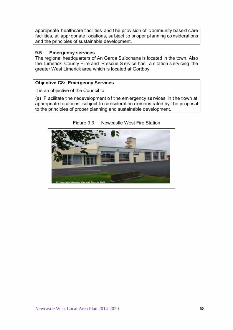
Newcastle West Local Area Plan 2014-2020 68
appropriate healthcare f acilities and t he pr ovision of c ommunity base d c are facilities, at appr opriate l ocations, su bject t o pr oper pl anning co nsiderations and the principles of sustainable development. 9.5 Emergency services The regional headquarters of An Garda Suíochana is located in the town. Also the Limerick County F ire and R escue S ervice has a s tation s ervicing the greater West Limerick area which is located at Gortboy.
Objective C8: Emergency Services It is an objective of the Council to: (a) F acilitate t he r edevelopment o f t he em ergency se rvices in t he t own at appropriate locations, subject to consideration demonstrated by the proposal to the principles of proper planning and sustainable development.
Figure 9.3 Newcastle West Fire Station

Newcastle West Local Area Plan 2014-2020 69
CHAPTER 10 URBAN DESIGN Strategic Policy for Urban Design in Newcastle West Policy UD1: It is the policy of the Council to promote high quality design throughout the Plan area and ensure that future development in Newcastle West is guided by principles of best practice and sustainability. 10.1 Introduction Good urban design is essential in creating attractive places for people to live in, w ork in and r elax i n. I t i s achieved by t he ar rangement of st reets and spaces, t he scale, a nd desi gn o f buildings, t he materials used, the colour scheme and finishes of bui ldings, and the layout o f roads and footpaths. A well designed urban area has a cl ear and distinct sense of place instilling a sense of community and pride with a clearly defined centre which is desirable to w alk around an d feels safe. A s uccessfully desi gned ur ban a rea w ould generally take the following into consideration: 1. Context: How does the development respond to its surroundings? 2. Connections: How well i s the new si te connected to t he t own a nd
community facilities and services? 3. Inclusivity: How easily can people use and access the development? 4. Variety: How does the development promote a good mix of activities? 5. Efficiency: How does the development make appropriate use of resources,
including land? 6. Distinctiveness: How do the proposals create a sense of place? 7. Layout: How does the proposal create people-friendly streets and spaces? 8. Public realm: How safe, secure and enjoyable are the public areas? 9. Adaptability: How will the buildings cope with change? 10. Privacy/amenity: How do t he b uildings provide a dece nt st andard of
amenity? 11. Parking: How will the parking be secure and attractive? 12. Detailed design: How well thought through is the building and l andscape
design? This Chapter provides general g uidance t o assist pr ospective app licants by outlining the aspects of planning and design that the planning authority will be taking into account when assessing applications for future development. The DECLG also recommends using the UK’s “Manual for S treets” (Dept o f Communities and Local Government, 2007) in designing residential streets. On a l ocal l evel t he Limerick County D evelopment P lan 2 010 – 2016 has placed g reater em phasis on a ppropriate desi gn i n i ts development management g uidelines. It i s a r equirement that a desi gn st atement i s submitted as part of a pl anning appl ication. A ‘Design Statement’ is a short

Newcastle West Local Area Plan 2014-2020 70
document w hich ena bles the ap plicant to explain w hy a par ticular desi gn solution is considered the most suitable for a particular site. 26
10.2 Derelict and Vacant sites
There are 3 derelict si tes on the Council’s Derelict S ites Register under the Derelict Sites Act 1990. According to the 2011 Census there were 534 vacant residences i n the t own w hich acco unts for ap proximately 15% of t he total housing stock in the town. F rom a town survey carried out in February 2013 by the Council it was observed that vacancy and dereliction is an issue along South Quay, Bridge Street and Maiden Street. These areas were identified in most need of regeneration. In an effort to encourage the use of buildings in this area the Council introduced a business and retail incentive scheme for the town centre. Refer to Chapter 5, Section 5.3 of this Plan. The high level of vacant properties impacts on the physical appearance of the town. Some are very obvious, for example, the large former commercial unit on Lower Maiden Street, or the Deel Co-op building occupying a focal location in the town on Sheehan’s Road or the Bridge House on the junction of Bridge Street and South Q uay. H igh vacancy rates have de trimental effect on t he amenity of the town as properties fall into disrepair and are poorly maintained. Vacancy can also have a contagion or viral effect as it often is clustered.
Figure 10.1 Examples of vacant buildings on Lower Maiden Street, Sheehans Road and Knockane
In relation to derelict and vacant sites, the general approach is to seek timely actions and i mprovements of si tes, t hrough posi tive eng agement w ith
26 Refer to Limerick County Development Plan 2010-1016, Section 10.4, Design Statement

Newcastle West Local Area Plan 2014-2020 71
landowners, using powers under the Derelict Sites Act only where necessary, and taking into account:
a) outstanding planning permissions, b) evidence of efforts to address vacancy and dereliction, c) security, safety to the public and condition of the site, d) the conservation value of the building and requirement for remedial restoration works, and e) t he feasibility of v arious actions to make g ood t he si te, and find viable uses for the site.
10.3 Public Realm Public realm refers to the areas of cities, towns, villages and suburbia that are generally freely and publicly accessible. It includes all the components of the built env ironment su ch as streets, parks, bridges and buildings and other urban features such as road and path surfacing, street furniture, and signage. The q uality of a n ur ban sp ace co ntributes to a se nse o f pl ace, pride an d uniqueness in a t own and has an i mportant cu mulative ef fect of one’s impression of the town, be they a resident or a visitor to the town. In terms of public realm Newcastle West has many positive attributes such as the S quare, w ith a r ich t raditional bui lt fabric having a num ber o f P rotected Structures, an d a n A rchitectural C onservation A rea focused on t he S quare, Maiden S treet a nd B ridge S treet, a number o f bui ldings on the N IAH27
, Desmond Hall, the riverside walk on the River Arra and the Demesne.
Figure 10.2 Examples of positive contributors to public realm in Newcastle West
However, t he q uality o f public realm c an be depleted by m any f actors including vacancy, neglect, dereliction, inappropriate parking, litter, wire scape and ot her i nfrastructural/utilities equipment and st ructures, po or desi gn o f buildings, i nappropriate modern materials used on older buildings, quality of 27 National Inventory of Architectural Heritage of Ireland refer to: http://www.buildingsofireland.ie/
Newcastle West Local Area Plan 2014-2020 72
road and p ath su rfaces, a nd st reet furniture. U nfortunately, as with m any other towns Newcastle West is also susceptible to these threats. Public realm c an be improved an d en hanced bo th i n t he sh ort term a nd through l ong t erm pr ogrammes. M any sm all i mprovements can h ave a significant ov erall i mpact. I t i s important t hat the q uality o f p ublic realm becomes a sh ared r esponsibility of t he l ocal co mmunity, busi nesses, l ocal property owners and not just the Council. Individual buildings contribute to the overall quality of the streets be it a posi tive or indeed a negative one. I n the short term, efforts to clean, paint and maintain property and public spaces can make a si gnificant i mprovement to public realm i n t he t own and t he impression given of the town. O ther measures such as appropriate planting, removal o f o bsolete s igns and st reet furniture, c ombining st reet si gns and furniture, co -coordinating types, st yles and colours of st reet furniture further enhance p ublic realm. L onger t erm, si gnificant but more co stly m easures include undergrounding streetscape wires, reducing asphalt road surfaces by introducing co ntrasting su rface t reatments and i mproved r elevant si gnage. While addressing the issue of improving public realm in Newcastle West it is important to be aware of cost and long term maintenance of any proposals.
10.4 Newcastle West Opportunity Areas Strong ce ntres are i mportant for st rong l ocal co mmunities. The D ECLG states that local area plans can play a key role in activating the development potential of central sites though identification of opportunity sites and general briefs su ggesting ap propriate f uture use 28
. The pur pose o f t he opportunity sites identified by this Plan is to encourage the restoration, consolidation and improvement of these mostly located in the town core. Appropriate, sensitive redevelopment of these sites would consolidate the town whereby amenities are w ithin walking di stance. D evelopers are st rongly adv ised at an ear ly stage t o eng age w ith t he pl anning a uthority and avail of a pr e-planning meeting to discuss their proposal. The Plan identifies 6 opportunity sites the town. These are:
Opportunity Area 1 Lands to rear of Church Street and Bishop’s Street Opportunity Area 2 Brewery Lane Opportunity Area 3 Former Olympic Ballroom on Sheehan’s Road Opportunity Area 4 River Arra walkway Opportunity Area 5 Churchtown Opportunity Area 6 Nash Backlands, The Square and Castle Demesne
Backlands, The Square
28 Local Area Plans – Guidelines for Planning Authorities, DECLG 2013, page 33

Newcastle West Local Area Plan 2014-2020 73
Figure 10.3 Location of Opportunity Sites, Newcastle West Opportunity Area 1 – Lands to rear of Church Street and Bishop’s Street Location and context This area is located on backlands in the town centre between Church Street and B ishop’s Street t o t he north o f t he Square. It i s approximately 0. 4 hectares in ar ea an d co nsists of a nu mber of si ngle st orey and 2 st orey residences and former commercial units on the ground floor on Church Street, and a stone masonry business operating to the rear with access from the lane to the public car park. B ridewell Lane provides pedestrian access to B ishop Street. T here i s a high level of vacancy o n Church S treet and some o f the more recently built retail/commercial units on Bridewell Lane are also vacant. The si te i s zoned t own centre i n t his Plan and i s located i n an ar chitectural conservation area.
Figure 10.4 Opportunity Area 1
Not to scale

Newcastle West Local Area Plan 2014-2020 74
Development potential 1. Any pr oposal s hould m aximise t he opportunity o f t he existing pedestrian access at Bridewell Lane and access to the existing car park. The design and layout shall reflect this and active frontage should address the car park. 2. The a malgamation o f plots is encouraged. A co mprehensive masterplan will be r equired to demonstrate a pl anned, integrated scheme for the re-development of the area to avoid piecemeal development which could inhibit the future potential of the area. 3. Desirable r e-development o f the si te i ncludes, a mix o f residential units, tourist related services, small scale tourist accommodation, small scale office dev elopment or a civ ic f acility f or t he ar ts such as studios or sm all theatre. 4. New bui ldings shall g enerally be si ngle st orey or two st orey, si mple and co nsistent i n d esign with t he t raditional st reetscape. S ensitive contemporary design is open to consideration. A design brief will be required of any proposal demonstrating the rationale for the proposed design chosen by the developer. 5. In the event that the existing archway is replaced on Church Street to provide access to the rear, the scale shall not be a pr ominent feature on the front façade.
Opportunity Area 2 Brewery Lane Location and context This site acts as a formal thoroughfare linking the Super Valu supermarket in Market Square to Maiden Street. It is located approximately 100m east of the Square i n t he ACA and w ithin t he cu rtilage o f a n umber o f P rotected Structures. The public do not access at night. Since the 2008 LAP Cronins Public House has redeveloped their property fronting the lane as an external smoking shelter. Unfortunately, the general impression along the lane is one of neglect with a poor quality path and wall surface, and unsightly open storage along the lane.
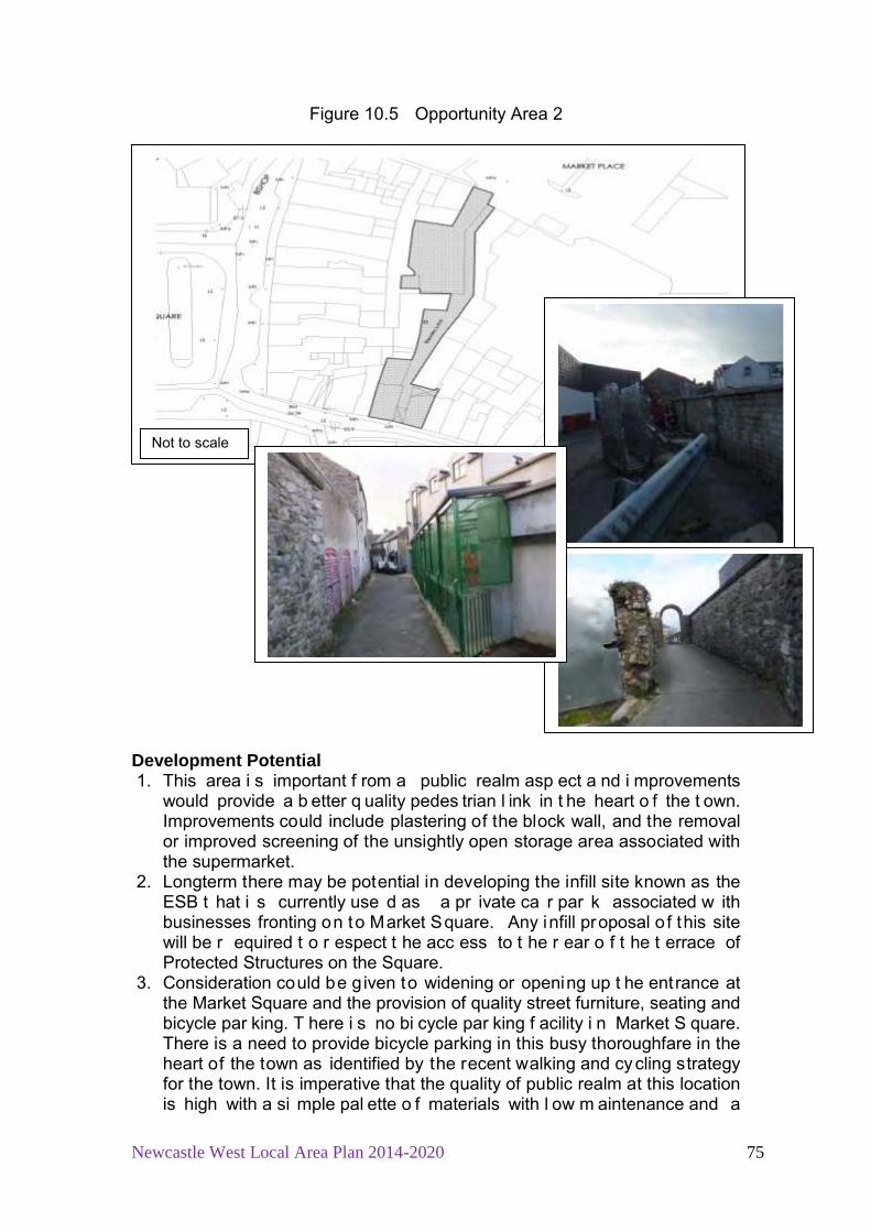
Newcastle West Local Area Plan 2014-2020 75
Figure 10.5 Opportunity Area 2 Development Potential 1. This area i s important f rom a public realm asp ect a nd i mprovements
would provide a b etter q uality pedes trian l ink in t he heart o f the t own. Improvements could include plastering of the block wall, and the removal or improved screening of the unsightly open storage area associated with the supermarket.
2. Longterm there may be potential in developing the infill site known as the ESB t hat i s currently use d as a pr ivate ca r par k associated w ith businesses fronting on to Market Square. Any infill proposal o f this site will be r equired t o r espect t he acc ess to t he r ear o f t he t errace of Protected Structures on the Square.
3. Consideration could be given to widening or opening up t he ent rance at the Market Square and the provision of quality street furniture, seating and bicycle par king. T here i s no bi cycle par king f acility i n Market S quare. There is a need to provide bicycle parking in this busy thoroughfare in the heart of the town as identified by the recent walking and cy cling strategy for the town. It is imperative that the quality of public realm at this location is high with a si mple pal ette o f materials with l ow m aintenance and a
Not to scale

Newcastle West Local Area Plan 2014-2020 76
consistency in design of the street furniture. It is important that this space becomes the sh ared responsibility o f t he l ocal co mmunity, b usinesses, local property owners and not just the Council.
Opportunity Area 3 Former Olympic Ballroom/Deel Wholesale Co., Sheehan’s Road
Location and Context This site i s located on t he j unction b etween Sheehan’s Road a nd t he Assumpta P ark. I t i s located approximately 400m nor th e ast o f M arket Square. I t i s a v isually pr ominent si te with r oad frontage o n t wo si te boundaries. The site area is approximately 0.25 hectares and the building is approximately 117square metres with a stepped front façade commonly found at ballrooms around the county. The site is zoned enterprise and employment.
Figure 10.6 Opportunity Area 3 Development Potential 1. Due to the prominent location of this site the development of these lands
would se rve as a ‘ landmark’ dev elopment, co ntributing t o a ‘ sense of place’ and enforcing a positive image of the town. The zoning offers many uses open for consideration i ncluding, o ffices, l eisure and cu ltural uses. Refer to table 11.2 the zoning matrix for this plan.
2. Connectivity and l inkage f or b oth t he p edestrian an d cy clist will be a n important c onsideration i n the pr oposal. The bui ldings should b e orientated t o ens ure active f rontage on t o the s treets. C areful use of landscape and su itable t ree sp ecies create a more i nteresting a nd engaging streetscape and will soften the visual aspect of the proposal in this area. High quality boundary definition and treatments and signage will be ex pected as the si te has road frontage on t he e ast an d w est boundaries. H igh boundary walls will not be per mitted on these boundaries.
3. Traffic m anagement will be an i mportant c onsideration i n a ny pr oposal with parking to be provided on site. No on-street parking will be permitted
Not to scale

Newcastle West Local Area Plan 2014-2020 77
due to the proximity of the junction and the existing congestion observed at times on Sheehan’s Road.
Opportunity Area 4 River Arra Walkway Location and Context This area i s located a long t he R iver A rra for appr oximately 300 m bet ween Courtney Bridge and B ridge Street. T he area is proposed to form part of a greenway i n t he Walking and C ycling S trategy f or t he town publ ished January 2013 that extends along the river bank past Desmond Hall linking to the Castle Demesne.
Figure 10.7 Opportunity Area 4 Development Potential Future development is restricted due to the high boundary walls of properties fronting Maiden Street along the path. In order to facilitate safe cyclist and pedestrian movement an elevated boardwalk could be provided over the river subject to appropriate ecological assessment. Opportunity Area 5 – Churchtown Location and Context This area is located south of Station Road and approximately 12 hectares. I t is zoned Residential Development Phase 1 and within walking distance of the town ce ntre, the G aelscoil, an d t he l ocal sh op an d p etrol station a t Ballintemple Cr oss. I t i s also w ithin w alking di stance o f t he D emesne parkland and is adjacent to the Great Southern Trial.
Not to scale

Newcastle West Local Area Plan 2014-2020 78
Figure 10.8 Opportunity Area 5
Development Potential It i s important that a ny new dev elopment l inks into the tr ail, l ands z oned education and community to the north east, and the town centre to ensure that local r esidents have easy access to t he t hese f acilities. The design of new development w ill be required t o provide a p roper walkway/cycle way access onto the trail. Dwellings will be required to overlook the access to the Trail and rear boundaries will generally not be permitted along the trail. Opportunity Area 6 - Nash Backlands, The Square and Castle Demesne Backlands, The Square Location and context: The Richard Nash backlands site is located directly to the west of the Square, with access from a passageway beside Nash’s Building (Protected Structure). The si te al so has road frontage ont o t he s treet se rving B allygowan Water Production Plant and t he Castle Demesne. The southern edge is defined by the River Arra open space and South Quay. This large un der-utilised ar ea occu pies land adj oining t he r etail co re o f t he town ce ntre an d bet ween t he i mportant focal ar ea o f The S quare and t he Demesne. I t contains of variety of ex isting yards used for s torage and large ancillary buildings in light industrial / storage use. Development Potential: The site is zoned for Town Centre purposes in this LAP. G iven its strategic location i n r elation t o t he r etail co re, a nd i ts considerable si ze, t he si te
Not to scale

Newcastle West Local Area Plan 2014-2020 79
presents significant potential for reinforcing the use, function and character of the town centre. The site would provide an opportunity for significant retailing opportunities, as identified i n t he C ounty R etail S trategy. A co mprehensive master plan would be required to demonstrate the sensitive development of the site and, in particular, an appropriate mix and density of building uses; the means of vehicle access; the provision of substantial car parking to serve the development, t he t own ce ntre, a nd v isitors; t rees to be r etained so as to protect the historic setting of the area; pedestrian linkage with the town centre and the River Arra; and the approach to archaeological constraints. General requirement/constraints: De-listing of P rotected S tructure t o facilitate dev elopment w ould N OT be acceptable. S ite co nstraints include n umerous mature t rees; pr otected structures associated w ith D esmond C astle C omplex; and a Zone o f Archeological Potential.
Castle Demesne Site (south) Nash’s Building Site (south)

Newcastle West Local Area Plan 2014-2020 80
Chapter 11 Land Use Zoning
11.1 Purpose of Land Use Zoning The l and use z oning m ap of t he P lan guides development to appr opriate locations and should be read in conjunction with both the zoning matrix of this LAP and the Limerick County Development P lan, Chapter 10: Development Management Guidelines. The purpose of the land use zones is to indicate the types of development that are considered most appropriate in each area and to avoid competing and incompatible land uses. The zoning objectives allow developers to plan proposals with some degree of certainty, subject to other conditions and requirements as set out in the Plan. The l and use z oning m atrix i s intended as a general gu ide t o asse ss the acceptability or otherwise of development proposals, although the listed uses are not exhaustive. The various land use designations have been formulated on the following principles:
• Ensuring that land use designations will accommodate the potential population and growth needs of Newcastle West within and beyond the lifetime of the Plan;
• Encouraging the development of Newcastle West as a compact and coherent settlement;
• Ensuring an acce ptable bal ance o f l and us es in pr oximity t o one another;
• Supporting t he pr inciples of proper pl anning and s ustainable development of the area; and
• Identifying the characteristics of various primary land use categories in or der t o pr ovide a br oad pl anning framework, w hich g uides development to appropriate locations.
Newcastle West Local Area Plan 2014-2020 81
The following t able se ts out t he t otal z oned l and for t he v arious zoning categories in this plan compared with the totals designated in the 2008 LAP.
Table 11.1 Total Zoned Lands Zoning Area proposed
2014 LAP - ha Area in 2008
LAP - ha % change
Agriculture 45.6 8.3 +449 Enterprise and employment
71.32 74.6* -4.39
Education and community facilities
21.15 20.2 +4.7
Utilities 1.4 1.4 0 New r esidential Phase 1
63.45 32.5 +95
New r esidential Phase 2
40.98 18.8 +117
Existing residential
124.48 137.78 -9.65
Residential Serviced S ites –phase 1
24.907 17 +46.5
Residential Serviced S ites –phase 2
15.01 13.8 +8.879
Open sp ace and Recreation**
80.37 8 +904.62
Town centre 10.46 11.58 -9.67 Mixed use 12.63 38.34 -67.05 Tourism r elated development***
0 2.48 -100
Total 512.08 384.78 +24.47% * Refers to Industrial 1 and Industrial 2 in the 2008 LAP **Includes greenways as referred to in 2008 LAP *** Zoned in 2008 LAP. Considered sufficiently provided for under mixed use zoning in 2014 LAP
11.2 Non Conforming Uses Throughout the C ounty t here ar e use s which do not co nform t o the z oning objective o f t he ar ea. T hese i nclude uses which w ere i n ex istence o n 1s t October 196 4, or w hich hav e v alid pl anning per missions. Reasonable extensions to and improvement of premises accommodating these uses will generally be per mitted w ithin t he ex isting cu rtilage o f the d evelopment and subject to normal planning criteria.
11.3 Land Use Zoning Categories The various categories of zoning incorporated on t he Land Use Zoning Map and the Zoning Matrix are defined as follows.

Newcastle West Local Area Plan 2014-2020 82
Town Centre The pur pose o f t his zoning i s to pr otect and e nhance t he c haracter o f Newcastle W est’s town centre an d t o pr ovide f or an d i mprove r etailing, residential, commercial, office, cultural and other uses appropriate to the town centre while guiding the development of a consolidated town centre area. Any proposed retail development shall be in accordance with the provisions of the Retail Strategy for the Mid West Region, 2010-2016. Mixed Use The m ixed use zoning obj ective g enerally r eflects existing co mmercial uses located outside the core area of the town. I t is intended for a combination of residential, small scale retail and/commercial on the site subject to standards regarding r esidential amenity, par king, t raffic safety an d ot her pl anning considerations. I t is important that any redevelopment of these sites should not r esult i n u ndermining o f t he t own ce ntre’s primacy as a r etail ce ntre. Mixed use on undeveloped l ands at K illeline i s intended t o su pport t he provision o f a nei ghbourhood c entre providing g oods and se rvices to l ocal residents. Proposals on mixed use lands located on the N21 at Gortboy will be r equired t o de monstrate hi gh q uality design, i ncluding si gnage an d entrance t reatment. I t is envisaged that future developments at t his location should visually contribute to the approach to the town, and that development of these lands would serve as a landmark, reflecting a sense of arrival in the town, contributing to a ‘sense of place’ and enforcing a positive image of the town. Retail development which will undermine the Town Centre w ill not be permitted. Existing Residential The purpose of this zoning is to ensure that new development is compatible with adj oining use s and t o protect t he a menity of ex isting r esidential ar eas. Some home businesses may be open to consideration provided the activity is ancillary to the use of the house as the primary residence of the owner. The conversion o f hous es f or t he so le use for a busi ness/offices will not be permitted. Refer to section 5.5 of this Plan. New Residential Development Area This zoning pr ovides f or new r esidential development and ot her se rvices associated with residential development. While housing is the primary use in this zone, r ecreation, educa tion, cr èche/playschool, sh eltered h ousing an d small co rner s hops are al so e nvisaged, subject t o t he preservation o f residential amenity, t raffic considerations and compliance with Section 5.5 in Chapter 5 of this Plan. Residential Serviced Sites Residential s erviced si tes offer an alternative t o i ndividuals wishing t o bui ld and desi gn t heir ow n house s in an ur ban se tting w ith est ablished se rvices rather t han t he o pen co untryside. S uitable edg e-of-town lands have been identified w ithin t he LA P bou ndary t hat pr ovide t he oppor tunity t o ca ter f or these lower densities, so as to provide an alternative to sporadic development in t he r ural areas. P roposals for t he development of se rviced si tes shall comply with objective H3 in Chapter 4 of this plan. Permeability with existing
Newcastle West Local Area Plan 2014-2020 83
residential areas, facilities, and adjacent lands zoned for future development, pedestrian a nd cy clist m obility will be an i mportant co nsideration o f any proposal. Open Space and Recreation The pur pose o f t his zoning i s to pr otect, i mprove and m aintain o pen space and r ecreational ar eas. The ar ea o f t his zone has been i ncreased substantially in this Plan, particularly in Knockane and Dromin along the river banks and at Killeline. An additional 0.4 ha has been zoned for this use north of S tation R oad for t he p urposes of i mproving t he am enity of t he G reat Southern Trail. Education and Community Facilities The purpose of this zoning is to facilitate the necessary development of these facilities in tandem with the future growth of the town. Additional lands have been zoned in this Plan to accommodate future expansion of the graveyard on Station Road, and to facilitate further complimentary community uses beside the Gaelscoil on Station Road. Enterprise and Employment It is envisaged that these lands will accommodate high quality and sensitively designed enterprise and employment development and complementary uses as indicated in the zoning matrix. The form and scale of development on these sites shall be appropriate to their location having regard to surrounding land uses and sca le. Pedestrian and cy clist m obility w ill be an i mportant consideration of any proposal. All links/pathways will facilitate the pedestrian and cy cleway and will be f inished by t he dev eloper t o a hi gh st andard, contributing t o i mproving publ ic realm, an d m obility and c onnections with existing facilities and residential areas where possible. Agriculture The purpose of this zoning is to provide for the development of agriculture by ensuring t he r etention o f agricultural use s, protect t hem from ur ban sp rawl and ribbon development and to provide for a clear physical demarcation to the adjoining built up areas. Uses which are directly associated with agriculture or which would not interfere with this use are open for consideration. Dwellings will be co nsidered for t he l ong-term ha bitation o f farmers and their so ns or daughters and subject to the terms and conditions of the rural housing policy as set out in Section 3.9 of the Limerick County Development Plan. Utilities The purpose of this zoning is to provide for essential public services, existing and planned, such as waste water treatment plants or water towers. 11.4 Land Use Matrix The ap proach of t he C ouncil t o l and us es is determined by t he z oning objective for the area in which they fall. This is depicted in the following land use matrix which should be cross-referenced with the Zoning Map (Appendix One).

Table 11.2 Newcastle West Land Use Zoning Matrix 2014 - 2020
Development Existing / New Residential
Residential serviced sites
Enterprise and Employment
Open Space and Recreation
Town centre Education/ Community Facilities
Mixed Use Agriculture
Dwelling / / X X O X O X* Apartments O X X X / X O X Guesthouses O O X X / X O X Hotel/hostel X X O X / X O X Local Shops O X O X / X O X Retail Warehousing X X O X O X O X Supermarket >900 sq.m X X X X / X X X Take Away X X X X / X O X Pub X X X X / X O X Restaurant/Café X X O X / X O X Cinema/theatres/ Bowling centres X X X X / X O X Community Hall O O X O / / O X Nursing Home / N ursing hom e integrated with retirement homes O O X X O X O X
Health Centre/Clinic O O X X / O O X Hospital X X O X O X O X Church/School / / O O O / O X Open space/Recreational/Leisure O O O / O / O X Office X X O X / X O X Car Repair/Sales X X O X O X O X Petrol Station X X O X O X O X Wholesale/Warehouse X X / X O X O X Logistics X X / X X X O X Garden Centre X X O X O X O X Bank X X X X / X X X Sheltered/voluntary ho using, H alting Sites & Transient sites for Travellers O O X X X X X X
Childcare Facilities / / O X / O O X Bring Centre/Bank (e.g Bottle Banks) / / O O / / / / Burial Ground O O O O O O O / Allotments O O O O O O O O Key = / Generally Permitted O Open for Consideration X Generally not permitted. * Except for farmer or son / daughter where rural housing need demonstrated in accordance with the rural housing policy as set out in the Limerick County Development Plan


Appendix 1
Maps
Map 1: Newcastle West Zoning Map Map 2: Amenity Map Map 3: Protected Structures Map Map 4: Predictive Flood Zones

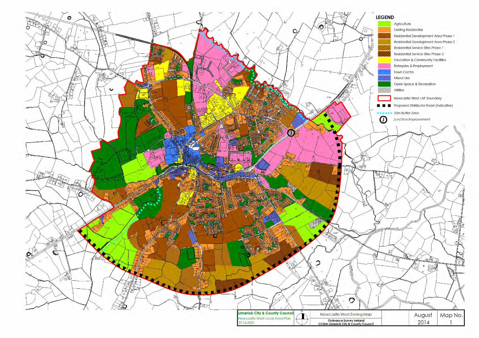
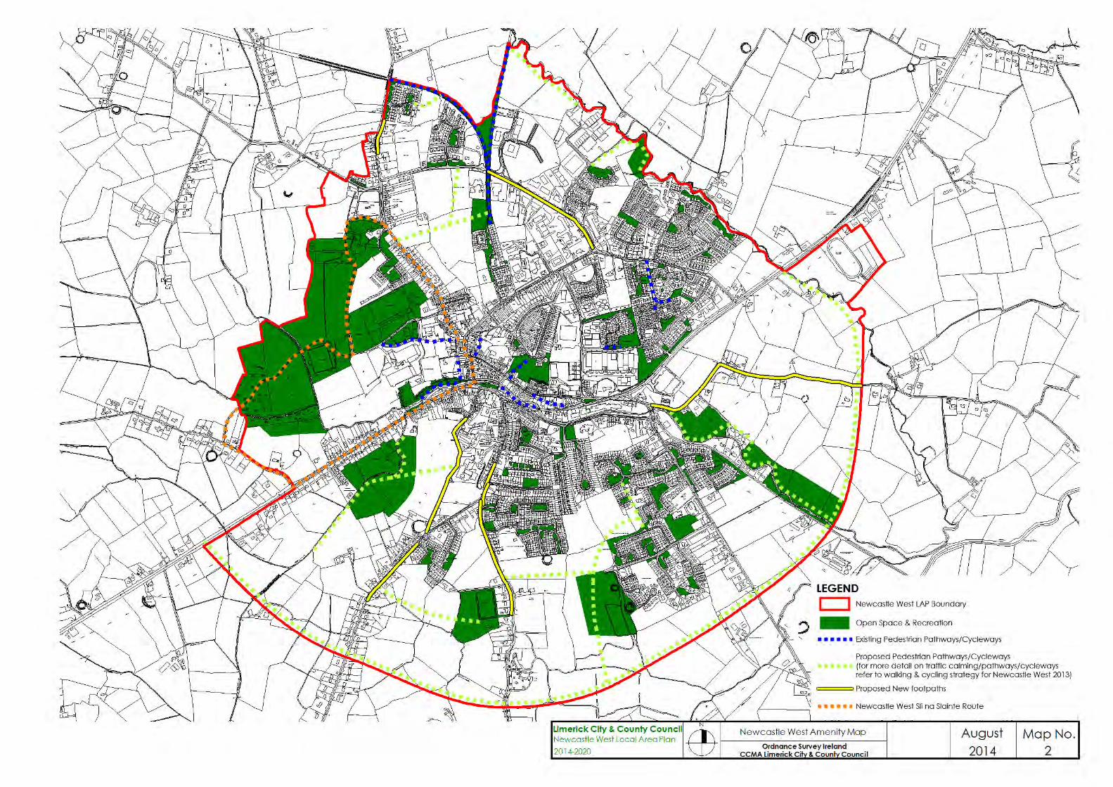


Appendix 2
Protected Structures and
List of Traditional Building Materials found in County Limerick
Architectural Heritage Part IV [Architectural Heritage] of the Planning and D evelopment Acts 2000-2013 allows for t wo grades of pr otection f or our bui lt her itage under i ts provisions. I n the first i nstance there i s the P rotected Structure. Secondly, there is the Architectural Conservation Area. Protecting t he built heritage und er t he provisions of P art I V o f t he P lanning and Development A cts 2000 – 2013 has positive bene fits for the st ructures concerned in that they become eligible for consideration under the provisions of the Conservation Grant Scheme operated by Limerick County Council. The listing of an individual structure, or the protection of an area through the establishment of an A rchitectural Conservation Area, provides recognition for those elements of the built heritage that are of significance. This significance can be divided into 8 basic categories: A rchitectural, artistic, archaeological, historical, social, cu ltural, scientific, t echnical. M any bui ldings, st ructures o r features carry more than one category of significance. Record of Protected Structures (R.P.S) The R ecord o f P rotected Structures is a st atutory docu ment maintained by each planning authority under the provisions of Part IV [Architectural Heritage] of the Planning and Development Act 2000-2013. Under the provisions of the legislation t he R .P.S. i s an i ntegral par t o f Li merick County C ouncil’s Development P lan. The l isting provided here i s an ex tract from the cu rrent Development P lan 2010-2016 and t he e ntries in t hat doc ument are t hose which have st atutory f orce. H owever, pr ovisions in t he A ct allow buildings, features and st ructures to be adde d t o t he Record w hen su ch an act ion i s deemed t o b e ei ther desi rable or nec essary. Consequently any one contemplating un dertaking works to a st ructure w hich ca n r easonably be believed t o b e o f ar chitectural, artistic, a rchaeological, hi storical, so cial, cultural, sci entific, or t echnical i nterest s hould m ake i nquiries with t he Council’s Conservation O fficer, F orward P lanning S ection, P lanning an d Development Department, as to whether a particular structure is protected or not. F urthermore, full pr otection i s afforded t o t hose el ements of t he bui lt heritage where a ‘ Proposed P rotected S tructure N otice’ i s issued under t he provisions of S.55 of the Act, pending the final resolution of the matter by the elected members of the County Council. A pr otected st ructure is deemed, under t he pr ovisions of S ection 2 o f t he Planning and Development Acts 2000-2011, to consist of the following: (i) the interior of the structure, (ii) the land lying within the curtilage of the structure,

(iii) any other structures lying within that curtilage and their interiors, and (iv) all fixtures and features which form part of the interior or exterior of any
structure or structures referred to in subparagraph (i) or (iii)”. Elements comprising the fabric of the structure (which at first glance may not be considered to be of importance or significance), such as lath and plaster finishes, external render, window and door frames and their associated joinery and fixings (such as latches and catches, and so forth), glazing, natural slate roofing an d t he su pporting st ructures, p ainted timber, as well as t he more obvious elements of the structure such as decorative plasterwork, are deemed to b e pr otected. Protection i s also a fforded t o the plan an d l ayout of t he building. For example, an internal partition dividing the entrance hall from the stairwell or a w all t hat separates a si tting room from a dining room, and so forth. Works to t he exteriors and i nteriors of protected s tructures or pr oposed protected st ructures (including the area deemed to be the curtilage of these structures) or in their settings, which may directly impinge upon t he fabric of the pr otected st ructure or t he c haracter o f t hose buildings may r equire planning p ermission. O wners or occu piers may ob tain cl arification t hrough the use of the Declaration Process set out in Section 57 of the Planning and Development Act, 2000, as amended in 2002. It m ust b e e mphasised t hat al terations to pr otected s tructures are no t prohibited. However, they should be considered interventions - all alternatives should b e ex plored and t he pr oposed ch anges must de monstrate t hat t hey are j ustifiable i n t he c ontext o f t he st ructure’s significance and the ow ner’s needs. Furthermore, interventions that are made should be capable of being reversible without loss of historic fabric or damage to the structure. Limerick County Council’s Conservation Officer is available to provide a general advice service t o o wners and occ upiers. However, t he pl anning aut hority recommends that those proposing to make changes engage the services of an appropriately qualified advisor to act on their behalf. The Royal Institute of the A rchitects of I reland has instituted a n accr editation pr ogramme for conservation architects. Refer to Section 8.2.4 General guidance f or undertaking works on older buildings of this plan.
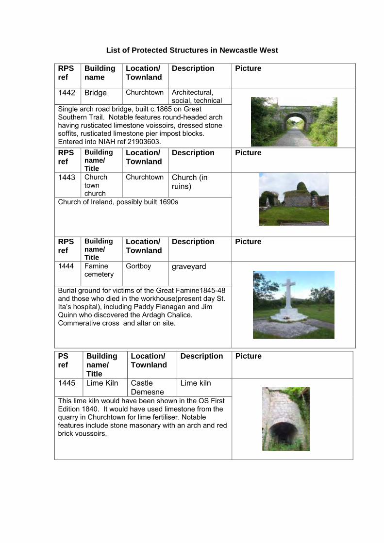
List of Protected Structures in Newcastle West
RPS ref
Building name
Location/ Townland
Description Picture
1442 Bridge Churchtown Architectural, social, technical
Single arch road bridge, built c.1865 on Great Southern Trail. Notable features round-headed arch having rusticated limestone voissoirs, dressed stone soffits, rusticated limestone pier impost blocks. Entered into NIAH ref 21903603. RPS ref
Building name/ Title
Location/ Townland
Description Picture
1443 Church town church
Churchtown Church (in ruins)
Church of Ireland, possibly built 1690s
RPS ref
Building name/ Title
Location/ Townland
Description Picture
1444 Famine cemetery
Gortboy graveyard
Burial ground for victims of the Great Famine1845-48 and those who died in the workhouse(present day St. Ita’s hospital), including Paddy Flanagan and Jim Quinn who discovered the Ardagh Chalice. Commerative cross and altar on site.
PS ref
Building name/ Title
Location/ Townland
Description Picture
1445 Lime Kiln Castle Demesne
Lime kiln
This lime kiln would have been shown in the OS First Edition 1840. It would have used limestone from the quarry in Churchtown for lime fertiliser. Notable features include stone masonary with an arch and red brick voussoirs.

RPS ref
Building name/ Title
Location/ Townland
Description Picture
1446 Former workhouse,
Gortboy Institutional – part of St.Ita’s hospital
Built c.1841 for Poor Union Commission, designed by George Wilkinson, with many notable features including tooled limestone walls, symetical façade typical of workhouses throughout the country. Entered into NIAH ref no.21837019 RPS ref
Building name/ Title
Location/ Townland
Description Picture
1449-1452
Almshouse A-D (in respective order)
Bishop Street
Terraced dwellings
Built c.1872, many notable features including carved timber barge boards, natural slate roofs with decorated ridge tiles. Entered into NIAH ref.21837015 to 21837018 inclusively.
RPS ref
Building name/ Title
Location/ Townland
Description Picture
1453 Courthouse Bishop street Urban structure-Civic
Built c.1841, designed by William Caldbeck. Notable features include dressed limestone masonry walls, round headed opes, rasied quoins and decorative balconies internally. Entered into NIAH 21837014.
RPS ref
Building name/ Title
Location/ Townland
Description Picture
1454 Earthlink Premises
Bishop street Commercial premises
Three bay two storey terraced building; plastered walls in smooth render; three timber sash windows on upper floor and one on ground floor; larger shop window but with no fascia. Slate roof.

RPS ref
Building name/ Title
Location/ Townland
Description Picture
1455 O’Riordans Hardware
Bishop Street
Commercial premises
Three bay two storey terraced building with timber shopfront. Notable features fluted pilasters framing the central door and the shopfront on both sides; console brackets framing the timber fascia; and a low railing above the cornice. First floor windows are timber double sash; the building has a slate roof. RPS ref
Building name
Location/ Townland
Description Picture
1456 “Dooleys” Bishop street Urban structure-Commercial
Two bay two storey terraced building. Plastered walls with raised stucco features around shopfront, windows and facade edges. First floor windows are timber double sash. Shopfront is characterised by a central recessed door on either side of which are two large plate glass windows.
RPS ref
Building name/ Title
Location/ Townland
Description Picture
1457 “Market House”
Market Place Urban structure-Commercial
Built c. 1873 replacing an earlier market house as marked on the OS First Edition Map (1844). Notable features include limestone walls with tooled limestone sills. Entered into NIAH reference 21837020
RPS ref
Building name/ Title
Location/ Townland
Description Picture
1458 Carnegie Library
Bishop Street
Commercial premises
Detached five-bay two-storey former Carnegie library, dated 1922 replacing burnt library constructed 1916. Designed by Richard Caulfield Orpen and James Leahy. Notable features include tooled limestone porch, decorative brackets to the eaves. Entered into NIAH ref no 21837021.

RPS ref
Building name/ Title
Location/ Townland
Description Picture
1459 Former bank
Church street Urban structure-Commercial
Built c. 1880. Notable features include tooled limestone plinth and sills, cast-iron rainwater goods, timber sash windows, natural slate roof. Entered into NIAH ref no 21837012. RPS ref
Building name/ Title
Location/ Townland
Description Picture
1460 “Matt Hanleys”
Church street Urban structure-Commercial
Three bay two storey terraced building; Notable features include vertically proportioned windows on upper floor; and a shopfront is with fascia that is flush with the wall, raised lettering, and quoins in stucco on both sides of the building.
RPS ref
Building name/ Title
Location/ Townland
Description Picture
1461 Irish Nationwide
Church Street
Urban structure-Commercial
Terraced three bay two storey building, notable features include slate roof, timber sash windows timber shopfront, raised surrounds with keystones and raised plaster quoins.

RPS ref
Building name/ Title
Location/ Townland
Description Picture
1462 “Crowley Brothers”
Church street Urban structure-Commercial
Terraced five-bay three-storey former shop, built c. 1900, having recent timber shopfront to front. Notable features include unusual geometric motifs to the eaves level. Entered into NIAH ref 21837004.
RPS ref
Building name/ Title
Location/ Townland
Description Picture
1463 “Nashs” Church street Urban structure-Commercial
Part of Nashs, which was set up in Newcastlewest in 1875 by Richard and Johanna Nash, one of a pair with ‘Crowleys’ RPS 1462. As per RPS 1462, unusual geometric motifs to the eaves level compliment the building’s appearance. Entered into NIAH ref 21837005.
RPS ref
Building name/ Title
Location/ Townland
Description Picture
1464 “Ella Maries”
The Square (north side)
Commercial premises
Corner sited 3 bay 2 storey former military barracks, built c 1840, which replaced a market house. Notable features include symetical façade decorated with numerous classically inspired motifs, Entered into NIAH ref no 21837011. RPS ref
Building name/ Title
Location/ Townland
Description Picture
1465 The Square
Church street
Civic
Planned and constructed by the Courtenay family. Contains recent sculptures. The square is framed by buildings generally in neo-classical style and three storeys in height of nineteenth century provenance.

RPS ref
Building name/ Title
Location/ Townland
Description Picture
1466 McMahons Solicitors
The Square (East side)
Commercial premises
Built c 1830, terraced three bay three storey former town house forms an integral part of a terrace of commercial and residential buildings. Notable features include limestone window surrounds and voussoirs. Entered into NIAH ref 21837022 RPS ref
Building name/ Title
Location/ Townland
Description Picture
1467 Marguerites The Square (East side)
Commercial premises
Built c 1830, terraced three bay three storey former town house. Entered into NIAH ref 21837023.
RPS ref
Building name/ Title
Location/ Townland
Description Picture
1468 Paddy Powers
The Square (East side)
Commercial premises
Built c 1830, terraced four bay three storey former town house. Entered into NIAH ref 21837024.
RPS ref
Building name/ Title
Location/ Townland
Description Picture
1469 Superbites The Square (East side)
Commercial premises
Built c 1830, terraced three bay three storey former townhouse having recent shopfront. Entered into NIAH ref 21837025.

RPS ref
Building name/ Title
Location/ Townland
Description Picture
1470 Daybreak The Square (East side)
Commercial premises
Built c 1830, terraced three bay three storey former townhouse, having recent timber shopfront. Entered into NIAH ref 21837026
PS ref
Building name/ Title
Location/ Townland
Description Picture
1471 Former bank
The Square (East side)
Commercial premises
Terraced three bay three storey former house, built c 1830. The inclusion of a recent cut limestone shopfront is a sympathetic addition and compliments the historic character of this fine former town house. Entered into NIAH ref 21837027.
RPS ref
Building name/ Title
Location/ Townland
Description Picture
1472 Griffin Brothers Butchers
The Square (East side)
Commercial premises
Terraced three bay three storey former house, built c 1830. The retention of historic features including cast-iron rainwater goods and the effective use of red brick creates a pleasing contrast against the dressed limestone façade, helping to preserve the building's historic character and enliven the façade. Entered into NIAH ref 21837028 RPS ref
Building name/ Title
Location/ Townland
Description Picture
1473 “Cronins” Bar and Lounge
The Square (East side)
Commercial premises
Terraced three bay three storey former house built c 1830. Notable features include cast-iron rainwater goods, an elliptical-headed doorway dressed limestone façade. Entered into NIAH ref 21837029
RPS ref
Building name/ Title
Location/ Townland
Description Picture
1474 The Knights Inn
The Square (East side)
Commercial premises
Terraced three bay three storey former house built c 1830. Notable features include cast-iron rainwater goods, camber-headed doors and windows. Entered into NIAH ref 21837030 RPS ref
Building name/ Title
Location/ Townland
Description Picture
1476 Shires/ Sculpture Beauty Salon
The Square (East side)
Commercial premises
Three storey terraced corner building. Notable features include plastered walls with smooth render; raised plaster quoins, double timber sash windows and traditional timber shopfronts. Vertical mullions on the shop windows enhance this building’s elegant appearance. RPS ref
Building name/ Title
Location/ Townland
Description Picture
1477 “Ed Lynch’s Bar”
The Square (South side)
Commercial premises
Three bay two storey terraced building, walls are plastered with smooth render, slated roof, traditional timber shopfront, and double timber sash windows.
RPS ref
Building name/ Title
Location/ Townland
Description Picture
1478 Bloomers café
The Square (South side)
Commercial premises
Terraced corner two storey corner building, traditional timber shopfronts on each façade. Exposed limestone masonry wall reveals a segmented arch over one of the shopfronts, beneath which is filled with red brick. Slate roof; nine double sash windows including five on the ground floor.

RPS ref
Building name/ Title
Location/ Townland
Description Picture
1479 Bank of Ireland
The Square (West side)
Urban Structure-Commercial premises
Detached five bay three storey former dwelling operating as a bank since 1864. It employs an Italian/Classical style and has retained a significant amount of its historic form and character. Its numerous and substantial decorative motifs attest to the high level of skill possessed by the nineteenth-century stone masons responsible for its execution. Entered into NIAH ref 21837006. RPS ref
Building name/ Title
Location/ Townland
Description Picture
1480 The Red Door (formerly ACC bank)
The Square (West side)
Urban structure-Commercial premises
End-of-terrace three-bay three-storey former bank, built c. 1870. The retention of key historic features including tooled limestone sills and sash windows. Entered into NIAH ref 21837007 RPS ref
Building name/ Title
Location/ Townland
Description Picture
1481 The Allied Irish Bank
The Square (West side)
Urban structure-Commercial premises
Detached five-bay three-storey bank, built in 1924, by James Finbarre McMullen. Notable features include ashlar limestone shopfront, sash windows and decorative brick and limestone pilasters. Plaque to Sophie Mary Peirce (later Lady Heath) of Knockaderry, the first pilot to fly solo from Capetown to London. Entered into NIAH ref 21837008.

PS ref
Building name/ Title
Location/ Townland
Description Picture
1482 Templars Castle
The Square (South side)
Medieval site-Castle
Includes the Big Hall, Banqueting Hall, Coach House and surrounding curtain walls. Also the site of the former Church of Ireland church and house of the Earls of Devon. Originally a castle of the Fitzgeralds, Earls of Desmond, later granted to the Courtenay’s under Queen Elizabeth 1. RPS ref
Building name/ Title
Location/ Townland
Description Picture
1483 Castle house
The Square (South side)
Art Deco house
Possible dating to 1920s associated features including walled garden and landscaping.
RPS ref
Building name/ Title
Location/ Townland
Description Picture
1484 ‘Jewels’ Maiden street[2]
Commercial premises
Two storey two bay terraced building. Notable features include slate roof, timber sash windows and traditional timber shopfront.

RPS ref
Building name/ Title
Location/ Townland
Description Picture
1485 ‘Cobblers’ Maiden street [5]
Commercial premises
Four bay two storey terraced building. Notable features include timber double sash windows, slate roof, narrow stand alone fascias surmount the two shop windows consisting of glazed plates framed by raised mouldings.
RPS ref
Building name/ Title
Location/ Townland
Description Picture
1486 “The Key House”
Maiden street/North Quay
Commercial premises
Formerly the Courtenay school, built in c1720. Three storey terraced building with slate roof and plastered walls.
RPS ref
Building name/ Title
Location/ Townland
Description Picture
1693 Not named Maiden street Terraced former commercial premises
Four bay two storey terraced building, notable features include slate roof, exposed stone façade, panelled window on ground floor with stall riser and free standing fascia panel above it, segmented arch.
RPS ref
Building name/ Title
Location/ Townland
Description Picture
1487 “Moones” Bridge street Dwelling/ Commercial
Terraced three-bay two-storey house, built c. 1840, Notable features include rendered shopfront, stone sills, internal timber shutters and sash windows. Entered into NIAH ref.21837034. streetscap

RPS ref
Building name/ Title
Location/ Townland
Description Picture
1488 Not named Bridge street [1]
Folly-now in commercial use (‘Fuller’s Folly’)
Building bears an inscription dating its erection to 1859. William Fuller Hartnett erected this castellated building on this site from lands he leased from the Earl of Devon, hence the name.
RPS ref
Building name/ Title
Location/ Townland
Description Picture
1489 Not named Bridge street [2]
Ancillary buildings and structures to Fuller’s Folly off Bridge Street, assumed to be built in 1850s.
RPS ref
Building name/ Title
Location/ Townland
Description Picture
490 Not named Bridge Street [3]
Medieval structure
Part of walls of the keep of Desmond castle still extant.
RPS ref
Building name/ Title
Location/ Townland
Description Picture
1491 Not named North Quay Bridge-Iron
Freestanding single-span cast and wrought-iron foot bridge, dated 1866. Distinctive for its use of pre-fabricated cast iron and a simple braced truss system when pre-fabricated techniques in cast iron were at an early stage of development. Entered into NIAH ref: 21837040.

RPS ref
Building name/ Title
Location/ Townland
Description Picture
1492 Not named North Quay Commercial building features
18th century coach houses
RPS ref
Building name/ Title
Location/ Townland
Description Picture
1494 Not named North Quay Urban Structure-Dwelling
Two bay three storey terraced dwelling. First floor windows have pronounced vertical emphasis and are taller than those on the top floor. This arrangement is a common feature of townhouses in Classical style, but is not typical of the North Quay.
RPS ref
Building name/ Title
Location/ Townland
Description Picture
1495 Not named North Quay Urban Structure-Dwelling
Two storey two bay terraced dwelling. First floor windows have raised surrounds. Ground floor has the framework and ornamentation of a traditional shop/pub front spanning it.
RPS ref
Building name/ Title
Location/ Townland
Description Picture
1496 Desmond Credit Union
North Quay Urban Structure-Commercial
Modern terraced four bay two storey building, purpose built for its present purposes. The design is sympathetic to its context in scale and uses quality materials and finishes in a modern style and pastel tones.

PS ref
Building name/ Title
Location/ Townland
Description Picture
1497 Not named North Quay Urban structure-Dwelling
Former hotel site with coach houses to rear. Listed for historical importance RPS ref
Building name/ Title
Location/ Townland
Description Picture
1498 Robert Cussen
North Quay Dwellings
Two attached town houses, built in 1840. All windows are timber and double sash. Windows on the western two bays have six panes for each sash; windows of the ground and first floors on the eastern two bays are tripartit. Entered into NIAH refs 2183078 and 2187039
RPS ref
Building name/ Title
Location/ Townland
Description Picture
1499 Not named North Quay Urban Structure-Dwelling
Two bay terraced three storey building, notable features include slate roof, timber shopfront with a narrow fascia spans, with low stall riser, and mullions.
RPS ref
Building name/ Title
Location/ Townland
Description Picture
1500 Not named North Quay Urban Structure-Commercial
Two bay terraced three storey building. Notable features include slate roof, ripartite Wyatt style timber windows timber shopfront with a discreet narrow fascia, supported by pilasters and consoles of simple design. Shop windows are attractively proportioned with mullions for vertical emphasis.

RPS ref
Building name/ Title
Location/ Townland
Description Picture
1501 Not named North Quay Urban structure-Dwelling
Two bay three storey terraced building with uniformly plastered walls and slate roof.
RPS ref
Building name/ Title
Location/ Townland
Description Picture
1502 Not named North Quay Urban structure-Dwelling
Two bay three storey terraced building with uniformly plastered walls and slate roof.
RPS ref
Building name/ Title
Location/ Townland
Description Picture
1503 Clancarthy House
Cullenagh Country House
House in two parts, L shaped in plan, both parts with slated roofs, and both dating from 19th century.
RPS ref
Building name/ Title
Location/ Townland
Description Picture
1504 Not named No.31 South Quay
Terraced house
Three bay two storey terraced house, slated roof; all windows are timber double sash.
RPS ref
Building name/ Title
Location/ Townland
Description Picture
1505 Not named No.28 South Quay
Terraced house
Three bay, two storey terraced house, with slate roof. Original stone walls exposed.
RPS ref
Building name/ Title
Location/ Townland
Description Picture
1506 Not named No.13 South Quay
Terraced house
Two bay two storey terraced house, with slate roof. First floor windows are timber double sash.
RPS ref
Building name/ Title
Location/ Townland
Description Picture
1508 Not named No.11 South Quay
Terraced house
Four bay two storey terraced house, with slate roof. Timber double sash windows on first floor.
RPS ref
Building name/ Title
Location/ Townland
Description Picture
1509 War of Independ-ence Memorial
South Quay (north side)
Wayside Memorial
Freestanding stone monument, erected in 1955, commemorating volunteers killed during the War of Independence and the Civil War. Included in National Inventory of Architectural Heritage (NIAH) ref 21837045.

RPS ref
Building name/ Title
Location/ Townland
Description Picture
1510 Church of the Immaculate Conception
Knockane Urban structure-Church
Freestanding cruciform-plan double-height gable-fronted Roman Catholic church, built in 1828, comprising nave with three-stage entry bell tower to side (east) of nave with two-stage canted stairwell block to side (east) of bell tower. Key features include Gothic revival façade and rose windows, which are later additions. Included in NIAH ref 21837042. RPS ref
Building name/ Title
Location/ Townland
Description Picture
1511 Cork Bridge Gortboy-Cloonyscrehane
Bridge-Masonry
Three bay arched stone bridge dated 1855, notable features include camber headed tooled arches with tooled limestone voussoirs, dressed stone soffits on rusticated stone piers, tooled stone corbels, dressed stone plinths, tooled limestone coping. Entered into NIAH ref: 21093613 RPS ref
Building name/ Title
Location/ Townland
Description Picture
1512 Not named Rathnaneane Detached building
Two storey, three bay building. Notable features include timber shopfront with pilasters and fascia, timber double sash windows with raised plaster surrounds and natural slate roof.

RPS ref
Building name/ Title
Location/ Townland
Description Picture
1513 Beechwood House Nursing Home
Rathnaneane Detached building
Previously St. Itas Presbytery; built as fever hospital in 1843. Key historic features including timber sash windows, tooled limestone sills and a fine timber panelled door. Included in the NIAH, reference 21837044
RPS ref
Building name/ Title
Location/ Townland
Description Picture
1514 St. Catherine’s Nursing home
Knockane Industrial-Institutional School
Former Sisters of Mercy Convent and convent chapel, built c1850. Notable features include tooled limestone window surrounds, quoins, slate roofs, timber sash windows, tooled limestone hood moulding, portico and nd carved timber tracery windows. Included in the NIAH, reference 21837043

List of Traditional Building Materials found in County Limerick Fabric: Limestone, br ownstone, sa ndstone or b rick, bo und w ith l ime
mortars Roofing: Natural Slate, Reed or Straws, with certain exceptions found in
some areas Rainwater Goods: Cast iron or galvanised sheet iron / mild steel Windows: Primarily Sash windows of varying patterns and designs, with
some exceptions Finishes: Painted lime renders of varying consistencies, often with
stucco detailing at returns, along floor lines and roof level, and on w indow or door ope s; A lternatively ei ther w ell-worked o r quality rubble stone, with appropriate joints in both cases were left ba re o r w ere or h ave had m ultiple l ayers of l imewash applied over the generations.
Paint: The use of any paints or other materials of modern composition, which seal the surfaces to which they are applied, should be avoided as they have a deleterious impact on lime based m aterials, w hether use d i n r enders or other finishes. The use of garish colours on walls or details of structures (such as quoins), which clash with the traditional range of pigments must be av oided as they i mpact ne gatively on t he cohesiveness of the s treetscape. I f i ndividuality i s sought, i t can be i mparted t o a bui lding t hrough hi ghlighting t he timberwork o f doo rs and t heir frames, w indows and g ates - features which are recessed sl ightly and out of direct v iew of those looking along the length of the conservation area.

Appendix 3 Recorded Monuments in the Newcastle West LAP area RMP Number Classification Townland Location LI036-069 Ringfort Ballymackesy 527756/632389 LI036-193 Ringfort Ballymackesy 527673/632418 LI036-067001 Historic town Castle Demesne,
Churchtown, Gortboy, Rathnaneane,
Knockane 527895/633831 LI036-067002 Castle Castle Demesne 527874/633708 LI036-024001 Church Churchtown 527479/634438 LI036-024002 Graveyard Churchtown 527480/634439 LI036-207 Enclosure Churchtown 527874/633708 LI036-180 Ringfort Cullenagh 527004/633725 LI036-211001 Country House Cullenagh 527651/633647 LI036-211002 Well Cullenagh 527657/633652 LI036-081 Ringfort Dromin 529417/633602 LI036-072 School Gortboy 528164/634115 LI036-075 Ringfort Gortboy 528433/634165 LI036-074 Ringfort Killeline 528276/632900 LI036-076 Ringfort Killeline 528573/632773 LI036-077 Ringfort Killeline 528636/632689 LI036-078 Designed landscape Killeline 528706/632969 LI036-079 Ringfort Killeline 528956/633069 LI036-068 Ringfort Knockane 527708/633043 LI036-070 Ringfort Knockane 527852/632616 LI036-210 Excavation Rathnaneane 528316/633039

Not to scale

Appendix 4
Abbreviations and Glossary Abbreviation Details AA Appropriate Assessment ACA Architectural Conservation Area BATNEEC Best A vailable T echnology N ot E xceeding
Unreasonable Cost CDP County Development Plan CFRAM Catchment Flood Risk and Management Studies CSO Central Statistics Office DEHLG Department o f Environment, H eritage an d Local
Government ED Electoral Division EIA Environmental Impact Assessment EIS Environmental Impact Statement DED District Electoral Division HSE Health Service Executive LAP Local Area Plan MWASP Mid-West Area Strategic Plan NATURA 2000 European N etwork of Special A reas of
Conservation and Special Protection Areas NDA National Disability Authority NDP National Development Plan NSS National S patial S trategy 2002 -2020, P eople
Places and Potential OPW Office of Public Works RPS Record of Protected Structures SAC Special Area of Conservation SEA Strategic Environmental Assessment SuDS Sustainable Drainage System Appropriate Assessment: An A ppropriate A ssessment i s required und er Article 6( 3) o f t he H abitats Directive and i s an ev aluation o f t he pot ential impacts o f a plan on the conservation objectives of a Natura 2000 si te, and the development, where nece ssary, o f m itigation or avoidance m easures to preclude negative effects. Architectural Conservation Area: A pl ace, ar ea, g roup o f st ructures or townscape, t aking account o f building l ines and heights, which i s of special architectural, historical, ar chaeological, ar tistic, cu ltural, sci entific, so cial or technical interest, or contributes to the appreciation of protected structures. Backland Development: Development w hich t akes place t o t he r ear of existing structures fronting a street or roadway. Biodiversity: The variety of life (wildlife and plant life) on earth. Brownfield Sites: An urban development si te that has been previously bui lt on but is currently unused. Convenience Goods: Goods that are required on a d aily or weekly basis by individuals and h ouseholds (such as food, al coholic and no n-alcoholic beverages, tobacco and non-durable household goods).

Development Charges: Charges or l evies placed on developers relating to the c ost of s ervices and ut ilities, w hich ar e pr ovided by Li merick County Council. Environmental Impact Assessment: The pr ocess by w hich w e m easure anticipated e ffects on the env ironment of a pr oposed de velopment or project. If the likely effects are unacceptable, design measures or other steps can be taken to reduce or repair those effects. Greenfield Sites: A piece o f o pen l and t hat h as not b een built on a nd i s therefore a vacant lot. Hedgerows: A n atural or se mi-natural r ow o f bus hes, sh rubs an d/or t rees forming a bou ndary. H edgerows help define places, act as shelterbelts, and add to biodiversity. They also offer significant wildlife habitat, including wildlife corridors which al low wild ani mals to m ove acr oss open co untryside, and provide food, nesting and roosting places. Household: One or more persons occupying a dw elling which has kitchen and bathroom facilities. Infill Development: Refers to dev elopment t aking place on a vacant or undeveloped site between other developments, i.e. an infill site. Infill Site: Small gap sites, unused or derelict land usually located in urban areas. Infrastructure:Drainage, water supplies, sewage treatment plants, sewerage networks, l ighting, t elecommunications networks, el ectricity and e nergy network, r ailways, r oads, buildings, sch ools, co mmunity f acilities and recreational facilities. Chief Executive’s Report: A doc ument outlining t he su bmissions made during t he pr eparation of t he D evelopment Plan, t he M anager’s co mments and recommendations on the submissions. Monument (Recorded Monument):An ar chaeological m onument pr otected under Section 12 of the National Monuments (Amendments) Act, 1994. National Spatial Strategy (NSS): A 20-year national planning framework for Ireland. It’s about people, places and potential, making the most of our cities, towns and rural places to bring a better spread of opportunities, better quality of l ife and be tter places to l ive i n. Key t o t he s trategy is the co ncept o f balanced regional development. Protected Structure: A b uilding, feature, site, or st ructure i dentified i n t he Development Plan as worthy of protection or preservation in accordance with Part IV of the Planning and Development Acts 2000 to 2013. Residential Densities: The nu mber o f r esidential uni ts per ar ea uni t (hectare). Social Housing: Housing provided for persons who are registered w ith t he Local A uthority on t he S ocial H ousing Waiting Li st, an d asse ssed as being eligible f or so cial ho using. The br oad c ategories of households who ar e eligible for social housing are set out in Section 9(2) of the 1988 Housing Act and i nclude the homeless, t ravellers, per sons living in un fit or ov ercrowded accommodation, the elderly, per sons with disabilities, p ersons w ho ca nnot reasonably afford to provide their own accommodation. Social Impact Assessment: A systematic documented analysis of t he availability of social facilities in a community/settlement. The purpose of a SIA is:

• To g ive a br oad ov erview of existing so cial i nfrastructure (services/facilities) cu rrently provided within the v icinity of a p roposed development site.
• To determine what m easures could be pr oposed as part of a development sch eme i n or der t o pr ovide f or so cial i nfrastructure (services/facilities) which ar e co nsidered by t he P lanning A uthority t o be deficient in the area.
Some planning applications are required to submit an SIA as part of their application as r equired by S ection 1 0.3 o f t he Li merick County Development Plan 2010 – 2016.