Embed Size (px)
Citation preview

Network City: Retrofitting the Perth Metropolitan Region to Facilitate Sustainable Travel
Carey Curtis
Senior Lecturer, Department of Urban and Regional Planning,
Curtin University of Technology Perth,
Western Australia
Contact: [email protected]

Network City: Retrofitting the Perth Metropolitan Region to Facilitate Sustainable Travel Abstract 'Network City', the latest 25 year planning strategy for metropolitan Perth, Western Australia, is
designed to realise the integration of land use and transport networks within established and new areas.
This paper examines the influence of urban form on travel patterns and the case for sustainable travel
outcomes in order to set in context the 'Network City' concept. The concept is described, and then the
paper focuses on the operational detail needed to progress towards fuller integration between the
transport network and the city it serves. This includes analysis of urban structure in the context of the
factors that influence efficient use of public transport: including residential density, intensity of
activity, and the hierarchy of activity centres. The implications for road planning are discussed where
land use-transport integration is the core objective rather than simply traffic efficiency. If sustainable
travel is to be facilitated there is a need to change both the operation of public transport and the urban
structure and these changes are mutually supportive.
Introduction
'Network City' is the latest 25 year planning strategy for metropolitan Perth, Western Australia. Its
preparation has provided the impetus for a new debate on urban form and sustainability. The Perth
metropolitan area's (population 1.4 million) low density suburban development spreads 130 kilometres
along the Indian Ocean coast. Single occupant car use dominates the transport mode share, and the road
network absorbs the bulk of transport expenditure (Gleeson et al, 2003) making delivery of a high
frequency public transport system a major challenge.
At the heart of Network City is a spatial framework designed to realise the integration of land use and
transport networks. Land use transport integration (LUTI) is seen as a means of achieving sustainable
travel outcomes, recently reinforced by Australia's National Charter on Integrated Land Use and
Transport Planning (DoTARS, 2003). The common approach to achieving sustainable transport is to
seek a shift away from single occupant private car travel towards high occupancy vehicles (both private
and public), cycling and walking, and the replacement of some trips with tele-shopping and tele-
1

commuting. Three different strategies can achieve this outcome: land use solutions (which have been
promoted through national planning guidance in many countries), demand management and the
promotion of alternative transport modes.
This paper reviews the urban form debate, examining the influence of urban form on travel patterns and
the case for sustainable travel outcomes, setting in context the 'Network City' concept. While 'Network
City' has a much wider perspective than its ability to improve LUTI, the aim of this paper is to focus on
this central issue and provide the operational detail needed to progress towards fuller integration
between transport networks and the city they serve. This includes analysis of urban structure in the
context of the factors that influence efficient use of public transport: residential density, intensity of
activity and the hierarchy of activity centres. There are implications for road planning where land use-
transport integration is the core objective rather than traffic efficiency. Translating 'Network City' from
theory into practice raises technical and methodological challenges for land use and transport planners
if land use and the transport network are to be integrated in a sustainable manner.
The influence of urban form on travel patterns
Urban form is defined by both the distribution and relationship of land uses (concentrated, evenly
spread, or nucleated) and the transport networks (radial, circumferential, or grid) that serve them
(Westerman, 1998). The notion that different urban forms can result in more sustainable travel
outcomes has its roots in the understanding that land use and transport are inextricably linked, and
accessibility (and therefore travel demand) is determined both by the proximity of land uses to each
other and to the transport network (including its capacity, operating characteristics and costs) (Webber,
1964; Keyes, 1982; Kelly, 1994; Westerman, 1998). Changes to land use and to transport
infrastructure therefore impact on travel patterns.
There has been a long standing interest in the form of cities, with extensive debate and commentary.
The motives for promotion of different forms have changed over time (Breheny, 1996) and the search
for a sustainable form is relatively new (Jenks et al, 1996). From the 1800's to the 1930's early planners
including Howard, Le Corbusier, and Wright, proposed large scale urban change as a solution to
concerns about health and the quality of life in industrial cities. During the 1950's and 1960's planners
were preoccupied with the uncontrolled spread of cities and their transition from monocentric city
2

forms to dispersed and polynuclear cities (the merging of monocentric cities) resulting in loss of rural
land. The central issue was identifying city forms could make efficient use of land (Gottman, 1957;
Lynch, 1961; Friedmann & Miller, 1965). There were also concerns about designing a city that did not
feel 'built-up' or 'uncontrolled' (Lynch, 1961; March, 1969).
The interest in urban form as a means of resolving transport problems is first noted in the USA where
the reaction to problems arising out of urban sprawl is that "the future shape of cities needed to deal
effectively with transport problems" (Buchanan, 1963, p. 186). During the 1970's, the 'oil shock'
provided a new context for examining the relationships between energy, land use and planning (Owens,
1984). North American simulation studies dominated the research scene. Studies by Schofer and by
Roberts in 1975, and by Keyes and Peterson in 1977 (all cited in Keyes, 1982), Van Til (1979) and by
the Municipality of Metropolitan Toronto in 1979 (cited in Brindle, 1992) all concluded that the least
energy consumptive urban form was 'polycentric' - an urban area comprising small, compact sub-
centres arranged in transport corridors.
Since the late 1980's the search for an efficient urban form has focused on transport's contribution to
the sustainable city. Analysis ranges from debating the merits of different theoretical 'ideal' forms, to
modelling simulations of 'ideal' forms, sometimes based on empirical data for a specific place, through
to use of aggregated or disaggregated empirical data to explore the impact of urban design variables on
travel behaviour and the relationship and strength of these variables compared with demographic and
attitudinal variables. The research covers both the macro-scale with its focus on determining the shape
of urban areas, and also the micro-scale with its focus on urban design factors such as density, transport
network and function, land use mix, and proximity.
At a macro level, studies from North America (Kumar, 1990; Douglas, 1991 cited in Handy, 1996;
Filion, 2001), Europe (Rickaby, 1991; Van der Valk and Faludi, 1992; Schwanen et al, 2001; Dieleman
et al, 2002; Cooper et al, 2001; Lloyd Jones et al, 2001) and Australia (Brotchie, 1992; Newman and
Kenworthy, 1996; Newton, 2000) advocate a 'polycentric' urban form claiming it could result,
variously, in a reduction in trip distance by car, reduced exposure to smog or more efficient fuel use.
Other studies suggested a 'compact' urban form (Freidmann et al, 1992 cited in Crane and Crepeau,
1998; Loder and Bayley et al, 1993; Kitamura et al, 1994 cited in Handy, 1996 and Ewing, 1997;
Simmonds and Coombe, 2000; Masnari, 2000) suggesting traditional suburban design may reduce trips
and travel distance. Not everyone supported the 'compact' city. Those who spoke against it were
3

branded as supporters of a 'dispersed' city, but in reality they were arguing only against a mono-centric
compact city form, preferring instead some form of decentralised concentration. Arguments focussed
either on the poor prospects of reversing the decentralisation trend (Breheny, 1992; Gordon and
Richardson, 1989 and 1997; Thomas and Cousins, 1996; Filion et al, 1999) or that the empirical studies
had not proven the case for a compact city (Gordon and Richardson, 1989 and 1997; Gordon,
Richardson and Jun, 1991).
Many other studies focus on the micro-level rather than the macro-level, examining particular design
parameters of the city thought important in influencing travel. But there is difficulty in isolating which
particular features were considered significant (Crane & Crepeau, 1998). Issues of urban density
dominate with findings showing that as densities increase vehicle kilometres travelled (vkt) reduce or
car trips reduce, although this was not a unanimous view (Holtzclaw, 1990 cited in Crane and Crepeau;
Cervero and Kockelman, 1997 cited in Van and Senior, 2000; Newman and Kenworthy, 1999; Konings
et al, 1996 and Naess et al, 1996 cited in Van der Waals, 2000; Burton, 2000; Guiliano and Narayan,
2005). Some studies indicated that settlement size (i.e. population) was significant, with larger
settlements being most energy efficient (Banister, 1991; ECOTECH, 1993). Distance from the CBD
was a factor, where living further from the concentrations of employment and facilities at the CBD,
results in longer distances travelled and a lower share of non-motorised journeys (Banister, 1991;
Naess and Jenson, 2002; Naess, 2002, 2005). Provision of local facilities or mixed-use development
reduces either trip distance, trip generation rates or car driver mode share, although not a unanimous
view, (Cervero, 1991; Cervero and Kockelman, Farthing et al, 1996 1997 cited in Van and Senior,
2000; Van and Senior, 2000) with some arguing that mixed-use is more important than density in
reducing trip distance (Verroen et al, 1995 cited in Handy 1996). Accessibility to, and provision of, an
efficient public transport system increases its mode share (Verroen et al, 1995; Cervero and Gorham,
1995 cited in Handy 1996; Frey, 1999) with a greater impact than employment density (Kirwan, 1992).
The layout and design of the street system has an impact with a grid system reducing VKT and travel
speed (Kulash et al, 1990 cited in Crane and Crepeau, 1998; Parson, Brinkerhof, Quade and Douglas
Inc., 1993 and Cervero and Gorham, 1995 both cited in Handy, 1996).
Despite the large number of studies there is a lack of consensus as to what constitutes an 'ideal' urban
form. This is partly a result of the lack of definition of particular urban forms being measured (Frey,
1999; Ewing, 1997). Much of the early work focuses on a compact city as a mono-centric model.
However, some researchers use the term 'compact' more loosely, applying it to an urban form that
4

comprises a city with several/many centres of which each is compact, yet sitting within a more
dispersed city – hence the term 'decentralised concentration'. This form is also referred to by some as
meaning a 'polycentric city'. But there is also an absence of agreement on the definition of
polycentricity (Kloosterman and Musterd, 2001; Moore and Thorsnes, 1994). It either encompasses one
metropolitan region, or it covers a much larger urban system linking several complementary
metropolitan regions like the Randstad in The Netherlands or the Kansua region in Japan (Batten,
1995). It can include a number of sub-centres but with the retention of a dominant centre, or multi-
centres with no single dominant core. Urban sprawl is also ill-defined including terms such as low
density, dispersed, decentralised, suburban, polycentric, scattered, leapfrog development, commercial
strips and single-use development (Ewing, 1997).
Compounding the problem is one of transferability. A large proportion of the analyses are based on US
cities followed by Europe and, to a lesser extent, Australia. The problem is that there is considerable
variation in settlement structure (Guiliano & Narayan, 2005; Schwanen et al, 2004; Schwanen et al,
2001). Australian cities share similarities with US cities in terms of their low density, spreading cities,
but with stronger CBD's are more like European cities (Mees, 2000; Buxton, 2000). There is also a lack
of consensus about the methodological approach. Some analysis is based on the use of aggregated data
for travel behaviour, demographics and land use for large metropolitan areas, whilst other studies are
based on disaggregated data for small localised areas; some analyses control for the effect of one of
these groups of variables in order to more carefully assess this impact, while others attempt to explore
the relationship between different groups of variables (Badoe and Miller, 2000).
Arguments about the importance of demographic influences, such as income or family structure
(Hanson, 1982 cited in Handy, 1996; Crane and Crepeau, 1998; Hilbers et al, 1999 cited in Van der
Waals, 2000; Stead et al, 2000; Schwanen et al, 2001; Guiliano and Narayan, 2005) and of attitudinal
influences relative to urban form influences (Kitamura et al, 1994 cited in Ewing, 1997; Krizek, 2003)
question the effectiveness that changes to urban form can have on the achievement of more sustainable
travel patterns. The reality is that all three factors (demographics, urban form and attitudes) work in
combination, so any strategy seeking more sustainable travel must address all three.
It is clear is that while there is agreement by most commentators that urban form has an impact on
travel behaviour, research on the extent of this impact is inconclusive and there is no consensus as to
the ideal urban form (Hickman and Banister, 2002; Sorenson, 2000; Williams et al, 2000). There are a
5
variety of urban forms that are more sustainable than typical development patterns of recent years
(Williams et al, 2000). The debate has 'crystallized' towards 'decentralised concentration'. This reflects
the reality that both decentralisation and concentration processes are at work in the city (Bertolini,
1999), some business and residences are decentralising, while others remain in centres of Australian
cities. The most widely agreed solution for sustainable transport outcomes in cities appears to be one
of multiple nodes of concentrated activity, a transition from a 'Uniplex City', with one central core of
activities surrounded by suburbs, to a 'Multiplex City', with several centres connected both physically
and by telecommunications (Srinivasan, 2002: Sorenson, 2001; Lloyd Jones et al, 2001; Filion, 2001;
Healey, 2000; Newton, 2000; Frey, 1999; Brotchie, 1992; Newman, 1992, 1996; Van der Valk and
Faludi, 1992; Kumar, 1990; Van Til, 1979).
The 'Network City' Concept Relationship to past strategies – the rationale for change
Since 1955 Perth's planning strategies have focussed on providing for accessibility through mobility,
assuming private cars will transport people to activity. An extensive road network was planned and
substantially built. The public transport system has a level of service that varies from a very minimal
and infrequent service for areas at the urban fringe to frequent services on radial routes serving the
Perth CBD. Despite the rhetoric of past planning strategies, Perth suffers from poor land use-transport
integration (Curtis, in press). Employment has spread from the CBD into inner and middle suburbs in
locations that are difficult to access by all modes of transport. Since the 1970's suburban development
has been low density (average 6 dwellings/hectare gross (dw/ha)), mostly within 'spaghetti'
subdivisions with curvilinear collector road networks and culs-de-sac. Most travel is undertaken by
private car (in 2003 81% of trips) reflecting Perth’s dispersed land use pattern and transport network.
But depending on location, between 6% and 15% of households do not own a car (Curtis, 2001). Add
to this those without access to the household car and there is a large section of the population
disadvantaged by the existing approach.
Several state government initiatives seek a change in direction, promoting the need to control urban
sprawl and overcome car dependence by ensuring public transport and non-motorised options are
feasible for many trips, rather than an approach dominated by low occupancy car travel (Department of
Transport et al, 1996; WAPC, 1997a; Government of Western Australia, 2003a). A planning code, on
6

trial since 1997 and based on new-urbanist principles, promotes the development of 'walkable
communities' where day-to-day activities can be served within a local area (WAPC, 1997b). Broadly,
the principles of new urbanism advocate a return to pre-1960s traditional urban forms. In the USA
New Urbanism’s Charter emphasizes “the reconfiguration of sprawling suburbs into communities of
real neighbourhoods and diverse districts” as well as “coherent” metropolitan planning (CNU 1996;
Katz 1994).
These initiatives challenge the appropriateness of the existing urban structure. The new planning code
promotes walkable catchments, at odds with the regional centres approach of previous metropolitan
planning strategies (Corridor Plan, 1970 and Metroplan, 1990) that promote car-based catchments. But
they all assume the 'planning by neighbourhoods' principle (Madanipour, 2001) - the notion that people
would live and work locally in 'self-contained communities'. However, it is widely acknowledged that
both individual travel patterns and the activities of business are more complex and diverse, having a
much wider 'spatial reach', with activities spanning the neighbourhood, district, sub-region, CBD and
beyond at different points in time (Cuthbert, 2003; Bertolini and Dijst, 2003; Madanipour, 2001;
Graham and Marvin, 2001; Lloyd-Jones et al, 2001; Calthorpe and Fulton, 2001; Bertolini, 2000;
Healey, 2000; Feitelson & Salomon, 2000; Webber, 1964). A spatial planning strategy must cater for
this by designing a land use and transport network with the capability of providing accessibility at all
spatial scales in a sustainable way (Gehl, 1987, p. 85), "...accessibility must be ranked as the dominant
criterion against which alternative settlement patterns must be judged. The spatial form and density
pattern that makes for the most access ...should be the structure most worth striving for." (Weber, 1998,
p. 204).
There was a need for a new metropolitan strategy capable of ‘bridging’ the competing planning
strategies found in the 1970's CBD/regional centres 'hub and spoke approach' (see Figure One) and the
1990's walkable neighbourhoods approach. It also needed to be capable of being retro-fitted to
existing, established urban areas as well as guiding new urban areas. Many theoretical models of 'ideal'
urban forms contemplate a 'blank canvas', but in reality this is not the case (Gordon and Richardson,
1989; Owens, 1984). The potential for change is limited by this and because there is considerable
inertia in the built environment (Headicar, 2003; Williams et al, 2000; Anas et al, 1997; Owens, 1984;
McNamara, 1993; Moore & Thorsnes, 1994). Therefore, new development, whether within the
existing urban area or at the urban fringe will be slow in achieving change to overall metropolitan
7

travel patterns. Land use change must be accompanied by changes to transport operations to be
effective.
insert Figure One: Metropolitan Perth – Regional Centres approach 1970 – 2003
The production of a new metropolitan planning strategy for the Perth and Peel regions began in 2003
with the launch of 'Dialogue with the City', described as a new way of 'doing planning' by collaborating
with the community. A one day planning forum with 1,110 participants was the culmination of a
process which included a random survey of 8,000 people, an on-line discussion group, school essay
writing and painting competitions and listening sessions. The forum was an interactive consultation
that involved group discussion about the future urban form of the metropolitan area, and a mapping
game, whereby groups selected one of four planning scenarios and experimented with the actual
development of the city. The four planning scenarios (two extremes - 'Dispersed City' and 'Compact
City', plus two polycentric approaches - 'Multi Centred or Regional City and the 'Connected Network
City') were designed to reflect distinctly different choices for development to the year 2031. They were
based on the assumption that an additional three quarters of a million people will need housing, in
about half that many new dwellings, with provision for 350,000 new jobs. In reality Perth already
reflects elements of all four of these scenarios - a city would rarely fit as one of these 'pure' forms, and
the reality is a complex and mixed pattern of urban form (Lynch, 1961). The 'connected network city'
scenario was ranked the first choice by 35% of delegates. Following group discussions at each of the
110 tables, 80% of tables chose this scenario for the mapping game; with 72% of tables producing a
'connected network city' as the final output (Government of Western Australia, 2003b).
The 'Network City' concept
Figure two shows the three key components of the 'Network City' concept for the Perth Metropolitan
area. 'Activity corridors' are centred on either a main arterial road or suburban railway line utilising
land up to 400m on either side of this transport spine. 'Activity centres' are developed at intervals
along the activity corridor as the focus of daily activity needs including small scale employment,
shopping and services, and medium to higher density housing all placed within walking distance of the
public transport stop at the centre. 'Transport corridors' are paired with one or more activity
corridors to form a network, and provide a fast moving route for inter-urban travel, so overcoming the
need for longer distance through-traffic to use activity corridors.
8

The transport network provides the key metropolitan structure, and is based on achieving a high level
of accessibility. The network of activity corridors and transport corridors are anchored by strong
regional centres. This network not only creates a hierarchy of centres suited to serving the different
needs of the population at different spatial scales (regional, district, neighbourhood), but also provides
a key role in integrating and supporting a transport network of different modal layers. It provides an
excellent walking and cycling network to and within centres close to home, high frequency public
transport between centres, and high speed car, freight and public transport movement across the region
but outside these centres. There is a strong interconnection between corridors so that they become part
of a logical network.
insert Figure Two: Metropolitan Perth - Network City Framework The main benefit of the development of a network of activity corridors and transport corridors is in
promoting sustainable urban growth. By accommodating urban population growth within higher-
density activity corridors it is possible to contain urban sprawl and use developed land more efficiently.
It provides an alternative to a choice of inaccessible locations at the urban fringe (particularly by choice
of transport modes). Locating major traffic generators within activity corridors and close to residential
populations has several benefits. It supports an efficient public transport service and provides the
opportunity for a mode shift to green transport modes since commercial and employment activity is
dispersed to activity centres in close proximity to residential areas. This offers the opportunity to
reduce individuals' travel distance and travel time. This approach helps to reduce congestion on radial
routes to the CBD. It also reduces the transport investment requirement at the fringe.
Network City's extraction The pedigree of 'Network City' can be traced back many decades. Arturo Soria y Mata's 1882 La
Ciudad Lineal for Madrid, uses a high quality transport network as the structuring device to create a
400m wide corridor of development centred on a tramway (Priemus and Zonneveld, 2003; Graham and
Marvin, 2001). Lessinger promoted a linear city in 1962 (Ewing, 1997). The concept of urban
development corridors is not new (Naude, 1991). Historically, it was known, albeit in somewhat
derogatory terms, as 'ribbon development', but the concept of development corridors since the 1930's
has been considerably refined. It has an application at different spatial levels, international, national,
metropolitan, and local. National corridors differ in their objectives and structuring principles in
9

comparison to the development of local urban/metropolitan corridors, the focus is on economic
function, the facilitation of industrial development, exports and tourism development.
The linear concept is extended across the metropolis through the development of a multi-centred city
comprising a network of mutually dependent sub-centres linked by transport corridors (see Lynch's
'Urban Star', 1961; de Wolfe's 1971 'Civilia' cited in Breheny, 1996; concepts by Rickaby, 1991; Duany
& Plater Zyberk, 1994; Wood et al, 1994; Frey, 1999; Roberts et al, 1999; Calthorpe and Fulton, 2001).
There are examples of planning strategies aimed at creating a network city, albeit at different spatial
scales (see Copenhagen, The Netherlands and Cape Town). The Dutch 5th national policy on Spatial
Planning 2001 advocated progression from the traditional compact city to a network of compact cities
where transport infrastructure is seen as the main structuring device connecting these (Priemus and
Zonneveld, 2003). Local Urban Activity Corridors formed the key to Cape Town's metropolitan
planning strategy with the expectation that these could provide for integration across different spatially
segregated populations and promote economic growth outside the CBD (Cape Metropolitan Council,
1996). The transit-oriented development corridor concept is promoted by Ontario and New Jersey
transit planners (Ministry of Transportation and Ministry of Municipal Affairs, 1995; New Jersey
Transit et al, undated). Many regional plans have proposed some form of radial corridor extension of
the city, including Perth's 1970 Corridor Plan. Generally these follow a hub and spoke configuration
centred on one CBD rather than a network linking all centres. Little thought was given to the width of
corridors and their ability to be served by public transport and non-motorised transport modes.
While the 'Network City' concept draws on and shares features of several other concepts, for example
the Dutch 'ABC location' policy, transit-oriented development, urban villages, and the Cape Town local
urban activity corridors, none of these concepts is holistic. The ABC location policy is strong on land
use, locating uses by matching the mobility needs of different land uses to the different accessibility
characteristics of location. However, it does not address the traffic function of arterial roads. The
transit-oriented development concept, whilst including a road network, does not directly address the
need for a regional road network for freight and car-based journeys (Ravetz, 2000). New urban villages
are rarely placed within the context of a regional plan, they have been built in isolation, and the
relationship between villages is rarely considered. The local urban activity corridor says little about
urban structuring principles. The significance of the 'Network City is its attention to regional structure,
accessibility and the land use/transport function of roads.
10

Moving from concepts to reality Development Oriented Transit – using efficient public transport as a means of urban structuring Land use-transport integration requires the "need to deal simultaneously with both transport and urban
development issues" (Bertolini, 1998, p. 17) – this is at the heart of Network City. In developing the
concept, the need for new planning techniques and new ways of working with public transport
providers became evident, particularly defining the density and intensity of land use in relation to
public transport capacity. This approach accords with the communities desire to make better use of
existing infrastructure (Government of Western Australia, 2003b), it will also provide the rationale for
proposing particular densities and development locations. The existing pattern of development is not
energy efficient and public transport systems are designed to meet peak-direction peak-hour flows and
are therefore inefficient (Lloyd-Jones et al, 2001; Tanner, 2003). This is demonstrated in the modelling
of an existing corridor in Perth where the bus service in the morning peak is over capacity on the peak
(CBD bound) direction but at only 4% capacity in the counter-peak direction (Table One).
The structure of the urban network, the relationship of corridors to the CBD and other activity centres,
is a more important consideration than density as it determines travel patterns (March, 1969; Hall,
1990; Gordon et al, 1991; Brindle, 1996; Schwanen et al, 2001; Naess and Jensen, 2002). An urban
structure capable of supporting an efficient public transport service suggests particular parameters for
the composition, size and location of centres within the network of activity and transport corridors.
Separation of employment locations from housing has made inefficient demands on transport
infrastructure and services. If half of the workforce has local employment this reduces transport
inefficiency since the transport system benefits from two-way flows, providing employment at centres
across the network. Even if all the local residents work elsewhere there will still be an exchange of
employees which will result in transport efficiencies (Klassen, 1990 cited in Westerman, 1998). There
is a need to develop a hierarchy of urban centres designed to provide a high level of public transport
accessibility.
Modelling Approach
Taking into account these issues, different land use scenarios were modelled using empirical data from
an existing corridor within the Perth metropolitan area. The corridor selected runs from the Perth CBD
south of the Swan River to the Fremantle regional centre serving the southern suburbs of Fremantle,
Melville and South Perth. There is also a rail corridor between Perth and Fremantle but this runs along
11

a different corridor north of the river and serves the western suburbs including Cottesloe, Claremont,
Subiaco and West Perth.
The aim was to achieve efficient bus use, defined as full bus loadings in both directions during the a.m.
peak. Data on existing residential densities, proposed residential densities, travel (mode share and
spatial reach) and the current bus service were collected. Currently 6% of all trips are on public
transport in Perth metropolitan area. Analysis of travel patterns in the Perth metropolitan region
(Lawrence, 2005) indicates that 80% of trips are made to local destinations. An assumption of 10 trips
per household was based on the average weekday trips in school term-time derived from data from the
Perth and Regions Travel Survey (unpublished data, Department for Planning and Infrastructure, 2004)
and used in strategic transport modelling for the Perth metropolitan region. Distribution of trips within
the activity corridor in the model is made according to the attractiveness of each centre. The base case
(current situation) uses the proportion of commercial floorspace at each centre. Calculating the number
of passengers boarding at each stop was derived from the number of households in each zone and mode
share. The number of passengers alighting was proportional to the number of dwellings east or west of
each bus stop.
A key decision is the relationship between urban form and bus stops as these impact on the type and
cost of the system (Kelly, 1994). Development should support the provision and use of public transport
in order to make it less circuitous, more convenient, more efficient and less expensive to run (Ministry
of Transportation and Ministry for Municipal Affairs, 1995; Mees, 2000). Therefore land use planners
have a significant role in affecting the viability of public transport (Barton et al, 2003), but public
transport planners also need to plan transit networks to maximise the development potential at stops
(Dunphy et al, 2004).
The existing corridor is 21.5 km, and with 67 bus stops (approx 300 to 400m apart), the bus travel time
in peak periods is about 64 minutes. This configuration requires eight buses to service the morning
peak, with only the first bus leaving Fremantle able to make a return trip during the two hour morning
peak period. Public transport use is significantly affected by the level of service provided.
The first modelling input was to change bus services to better service patrons. Stops were placed at the
focal point of existing centres. The activity corridor model has significantly fewer bus stops (24
compared to 67), based on the principle that no dwelling is more than a five minute walk to a bus stop.
12

The service change reduced the peak hour journey time by 21 minutes and achieved a saving in the
number of buses to serve the peak from eight to five, with three of these buses doing two runs (at
limited layover time) during the two hour peak period. Offering an express bus would attract higher
patronage and has the added benefit of providing these destinations with an accessibility premium
similar to railway stations (Dunphy et al, 2004; Mees, 1994; Kirwan, 1992). It would be possible to
further reduce the travel time by introducing bus priority measures, such as bus lanes and traffic light
priority systems. The placement of transit stops should avoid competition between modes, journeys of
greater than one kilometre should be served by public transport leaving those less than 1km to be
served by the bicycle (Dieleman et al, 2002).
The scenarios test urban structure and bus loadings based on the current transport mode share with
provision for a 15 minute frequency of service in the morning peak period. This amounts to a supply of
480 seats per two hour peak period. Five scenarios were tested (Table One) reflecting a different
structure of centres along the activity corridor. This structure dictates the ideal residential density
required to maximise efficiency of bus operations at the current mode share.
Table One: The implications for urban structure of efficient bus use
Maximum efficiency of bus use (at current
6% mode share)
Scenario Density (dw/ha gross)
east (CBD) bound
west bound
Current urban structure 8.5 145% 4% Current urban structure with 12% mode share 8.4 289% 8% Ultimate density if Town Planning Schemes implemented
25.5 429% 12%
Scenario 1:
Strong centres at corridor ends, very small centres of equal size between
14 100% 100%
Scenario 2:
Centre at one corridor end half attractiveness of other corridor end, all other centres small and equal to each other
9.6 100% 51%
Scenario 3: 13.6 99% 61%
13
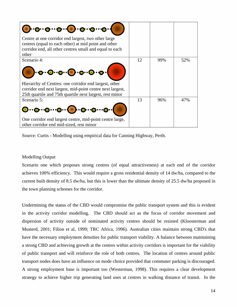
Centre at one corridor end largest, two other large centres (equal to each other) at mid point and other corridor end, all other centres small and equal to each other Scenario 4:
Hierarchy of Centres: one corridor end largest, other corridor end next largest, mid-point centre next largest, 25th quartile and 75th quartile next largest, rest minor
12 99% 52%
Scenario 5:
One corridor end largest centre, mid-point centre large, other corridor end mid-sized, rest minor
13 96% 47%
Source: Curtis - Modelling using empirical data for Canning Highway, Perth.
Modelling Output
Scenario one which proposes strong centres (of equal attractiveness) at each end of the corridor
achieves 100% efficiency. This would require a gross residential density of 14 dw/ha, compared to the
current built density of 8.5 dw/ha, but this is lower than the ultimate density of 25.5 dw/ha proposed in
the town planning schemes for the corridor.
Undermining the status of the CBD would compromise the public transport system and this is evident
in the activity corridor modelling. The CBD should act as the focus of corridor movement and
dispersion of activity outside of nominated activity centres should be resisted (Kloosterman and
Musterd, 2001; Filion et al, 1999; TRC Africa, 1996). Australian cities maintain strong CBD's that
have the necessary employment densities for public transport viability. A balance between maintaining
a strong CBD and achieving growth at the centres within activity corridors is important for the viability
of public transport and will reinforce the role of both centres. The location of centres around public
transport nodes does have an influence on mode choice provided that commuter parking is discouraged.
A strong employment base is important too (Westerman, 1998). This requires a clear development
strategy to achieve higher trip generating land uses at centres in walking distance of transit. In the
14

Perth CBD there is a danger of a spread of employment development beyond the 'sphere of influence'
of public transport. Instead this extra growth should be directed to other centres through planning
incentives.
Scenario three offers a superior outcome in terms of public transport efficiency compared to scenarios
2, 4 and 5. It also brings to the forefront the long standing debate about the relative place of other
centres, outside the Perth CBD, in the hierarchy. As Deputy Chair of the Corridor Plan Review
Committee, Dawkins argued that "middle ring districts with major retail facilities, industry zones ...and
high levels of accessibility" had the qualities for the development of strong CBD's (Dawkins, 1989,
p.8). The modelling confirms that middle ring centres offer 61% efficiency (Table One, scenario three).
Furthermore, they better utilise the bus fleet, requiring one less bus in the morning peak period, as a
result of the shorter corridor length. Running a 15 minute frequency service with a trip length of 30
minutes or less, duration makes the best use of the service requiring only four buses that are fully
employed in both directions. This suggests that a 'generic model' with a corridor length of 17.5kms
would be the most efficient. For some centres this will also place them at the junction of the freeway so
enhancing their multi-modal accessibility. On this basis it is argued that middle ring centres such as
Osborne Park, Cannington and Murdoch (Figure Two) should be promoted.
If middle ring centres are promoted it raises a question about the role of the five regional centres in
Perth's outer ring, promoted since the 1970 Corridor Plan. Activity corridor lengths to existing regional
centres (Figure one) vary between 17 and 28kms. Two studies suggest a solution. Naess (2005)
suggests for Copenhagen (a city of 1.8 million) a strategy of densification along the urban corridors up
to 10-15km out from the centre, but also the need to densify at 2nd order centres at the periphery (20-
30km out) where relatively high employment could compensate for the peripheral location. Lloyd-
Jones et al (2001) propose an urban structure with a strong CBD, linked to secondary centres lying 30
minutes travel time from the CBD and to the outer metropolitan edge arguing that this will strengthen
the city centre by maintaining contact with the urban periphery, there are no centres at the periphery.
Mees (2000) also promotes secondary centres at focal and intersecting points on the public transport
network.
Density and Structure If car dependence is to be reduced and the use of other travel modes increased, the relationship between
density and urban structure must be addressed. The scenarios modelled on the basis of public transport
15

efficiency suggest an increase in gross densities within 400m either side of the activity spine of
between 9.6 dw/ha and 14 dw/ha, depending on the structure of centres, compared to the current built
density of 8.5 dw/ha.
The use of a level of service specification for public transport has been used by others to determine
minimum residential densities required to support a particular service frequency (Table 2). Pushkarev
and Zupan examined the relationship between public transport use, density and urban design, finding
the need for dense agglomerations of non-residential floor space and higher residential density around
transit stops (Dittmar and Ohland, 2004). This approach has been widely adopted (e.g. Ontario
Guidelines, Ministry of Transportation and Ministry of Municipal Affairs, 1995). Messanger and
Ewing and Dittmar and Ohland have added to this work. The level of public transport subsidy assumed
is not stated. Based on the experience of North American cities, their applicability to Australian cities
is questionable given the different urban structure and level of investment in public transport.
Table 2: The relationship between density and service frequency
Service Frequency Min. Residential Density Required (Units) Puskarev & Zupan,
19771Messanger & Ewing, 19942
Dittmar & Ohland, 20043
Bus - 1 hour service 10/ha (4/acre) adjacent to corridor
N/A N/A
Bus - 1/2 hour service
17/ha (7/acre) adjacent to corridor
19/ha (8/acre) >12/acre (suburban neighbourhood)
Bus - frequent service (<15 mins)
37/ha (15/acre) adjacent to corridor
>26/ha (>11/acre) 48/ha (20/acre) (urban neighbourhood)
Rapid Transit 5 minute headway in peak hour
30/ha (12/acre) over extensive area with high density close to station
N/A >144/ha (>60/acre) (hub of radial transport system – urban downtown)
Source: 1Ministry of Transportation and Ministry of Municipal Affairs, 1995 citing Pushkarv B S and Zupan JM (1977) Public Transportation and Land Use Policy; 2Messenger and Ewing, 1994 cited in Dittmar and Ohland, 2004; 3Dittmar and Ohland, 2004.
In other studies, density is determined by 'optimum' walking distances to public transport or the town
centre together with size of population catchment needed to support a town centre. There is a
significant variation in density between different concepts. Calthorpe spaces corridors at one mile (1.6
km) intervals within a grid form. Within a quarter mile walk (400 metres) of each station he suggests a
gross density equivalent to 41 dw/ha and 92,900 sq. m. of commercial space, parks, and schools (Bressi
T W, 1994, citing Calthorpe). Westerman (1998) argues for a similar residential density of 40 dw/ha
within walking distance of public transport stops. The WA Liveable Neighbourhoods planning code
cited earlier recommends 12 dw/ha gross (WAPC, 1997b).
16

The basis for the 400m walking catchment is derived from early neighbourhood concepts. First
introduced by the British Ministry for Town and Country Planning in 1943, the neighbourhood was
intended to provide only those facilities needed for daily convenience, rather than being totally self-
contained, but this required a density of 120 persons per acre (around 30 dwellings/hectare), the rest of
the facilities would be in the town centre (Stephenson, 1992). Gehl suggests 400m as the "acceptable
walking distance for most people in ordinary daily situations" (Bostardens Grannskab, 1972, cited in
Gehl, 1987, p.139). A British Transport Road Research Laboratory study suggests that 600m is the
optimum range for walking (Dickens, 1975).
Roads - from traffic function to integration The 'Network City' concept requires a new approach for the design of arterial roads. Currently many
major arterial roads in Perth are 'controlled access highways' where the intent is to limit the number of
direct access roads onto the road in order to maintain the efficient movement of traffic along the road.
There are, however, limited restrictions placed on land use function abutting the road and high trip
generating land uses are common as are land uses more appropriate to town centre locations. A change
to the current classification is needed to take into account not only traffic function, but also land use
and quality of the urban environment (Westerman, 1998; Curtis, 2005). It should distinguish between
arterial roads for movement of traffic across the region (transport corridors), and sub-arterial roads
(activity corridors) where traffic management is needed to create safer, more attractive pedestrian
environments around activity centres (FORS & NSWRTA, 1993; Westerman, 1998). Following the
philosophy of the Dutch ABC location policy (Ministry for Housing, Physical Planning and
Environment, 1991), land use abutting transport corridors should be restricted to low trip generating
uses in order to maintain the transport function of the corridor.
Arterial roads running through activity corridors will need to be redesigned to provide an integrated
transport solution and frontage land use activity. Private car access is maintained, but in a low speed
environment, sharing road space with public transport, bicycles and pedestrians. Activity corridors will
continue to offer a route for through-traffic but its purpose will be for connectivity to other centres
along the corridor, rather than high-speed movement across the region. The concentration of more
intensive activities, including residential, along these corridors is unlikely to increase traffic noise and
air pollution since the aim is not to increase car traffic along the corridor. Instead most inter-suburban
17

traffic is redistributed to 'transport corridors' and 'within activity corridor car traffic' is redistributed to
other modes.
The 'activity corridor' is a street, a public place where activities bring people together (Jacobs, 1993)
and this requires a new approach to design of such places and to the management of traffic. While it is
possible to draw on the design ideas of those advocating shared streets (Engwicht, 1999; Gehl, 1987;
Westerman, 1998), it will require a new approach to traffic modelling and new ways of assessing road
capacity, rather than relying solely on 'predict and provide' demand forecasting and simple technical,
engineered systems (Graham & Marvin, 2001). The objective an activity corridor is to provide a shared
street at centres, contrary to traditional traffic modelling based on capacity, level of service, speed and
travel time reduction. Designs based on assumptions about mode split predicated on behaviour change
towards public transport and non-motorised modes will be needed that draw from examples of existing
accessible places. Also designs where land use function and the role of streets as multi-use meeting and
public transport spaces dominates rather than the carrying capacity of the road for vehicular traffic
alone (Barton et al, 2003). The highway capacity reduction study (Goodwin et al, 1998) found that
streets can continue to function with less capacity for vehicles resulting in a reduction in car trips by
'trip chaining' and replacement by increased use of other modes.
As activity corridors will contain significant populations and cater for passing traffic they will create
the right market threshold to support a wider range of economic activity. The corridor approach also
creates opportunities for businesses to be visible and accessible to passing traffic. The conventional
road hierarchy reinforces the inward orientation of streets and internalisation of business within
residential cells, and has limited the potential for the building of economic thresholds through the
sharing of amenities, including access to passing traffic (Green, 1990). The very nature of the
conventional road hierarchy puts the emphasis on servicing everyday needs/activities by private car and
the roadway capacity is inefficiently used through the day. Activity Corridors and their mixed use
centres can lower demand for longer distance trips, make better use of the road space over the day and
in both directions and increase the demand for public transport (Green, 1990; Naude, 1991). There will
be potential for congestion at activity centres as a result in the reduction of existing road space for the
private car in favour of other transport modes. This is consistent with the direction of state policy, and
is eased through the provision of transport corridors that decant through-traffic from the activity
corridor. In greenfield sites the timing of implementation of the transport corridor needs to be balanced
against the need to ensure that a robust use of activities within the corridor are established first.
18

The transport corridor is derived from the Cape Town metropolitan strategy, which suggests a strategy
for moving freight and higher speed traffic (express buses, intra suburban private car movements) by
providing a separate road network. This differs from new urbanist concepts which assume traffic will
be dispersed across the network through a finer grid rather than concentrating in few arterial roads in
the conventional road planning approach. The new urbanist concepts are not well designed for
application to existing urban areas. The opportunities for a fine grain network as envisaged may not be
available, particularly where modernist sub-division design has been employed with its functional
separation of both land use and traffic hierarchies. Jacobs (2002) boulevard model, now promoted by
Calthorpe in St Andrew's (a proposed new suburb on the fringe of the Perth metropolitan area), may
provide the integrated transport solution by catering for through-traffic and local traffic, and walking
and cycling within one corridor, but the ability to integrate with land use across the street may be
compromised, losing the very human scale that non-auto environments are aiming for.
The transport corridor is a necessary component of the Network City concept. There is a community
expectation of personal travel by private car, and an existing land use and transport network designed
for travel in this way. There is a tradition of car-based retail and commercial trips, particularly within
the middle ring of suburbs. But if transport corridors are to function as effective and efficient transport
routes and activity corridors are to attract the activities they need then land use must be controlled.
Otherwise there will be serious pressure for development to occur at these locations rather than along
activity corridors. The Dutch ABC location policy provides the tool. In a strong planning regime, the
intersection of transport and activity corridors will become highly prized places offering multi-modal
accessibility at the centre of highly accessible population catchments. Coined as the 'B locations' in the
Dutch ABC location policy, the ability to design for both the volume of development and car traffic at
the human scale needed will present a significant challenge.
Conclusion
'Network City' is not a blueprint plan to be translated carte blanche into physical reality but rather a
conceptual framework (Guy and Marvin, 2000) that promotes a particular pathway towards LUTI,
amongst other things. A review of the vast body of literature on urban form and sustainable transport
shows that there is no one universal model of the ideal city form, rather a number of approaches. There
is an emerging consensus towards a type of multi-centred city form centred on public transport
19

corridors. Several design principles can be seen to offer benefits in reducing travel distance, the number
of car trips and supporting public transport including urban structure (size, function, location of urban
centres relative to each other and to the CBD) and density.
The 'Network City' concept draws on this body of work, but also adds the detailed design parameters
necessary to work in tandem with the transport network and service delivery in order to support an
efficient public transport service. Changes to urban structure are required, including the targeted
decentralisation of employment to activity centres along activity corridors. High trip generating
development outside activity centres should be discouraged, particularly where it undermines the
function of transport corridors. A hierarchy of activity centres should be established maintaining the
strong role of the CBD, and promoting second order centres within the middle ring, ideally around 17
kms. from the CBD. The rationalisation of bus stops is required in order to make journey time savings
and so improve patronage, make efficient use of buses, and enhance the prospects for development
attracted by the accessibility premium. This can be achieved while maintaining a five minute walk to
bus stops. Changes to both urban structure and public transport efficiency are mutually supportive and
the essence of LUTI. The strength of the concept is its focus on a solution for established urban areas,
there is no 'clean slate'. This is a considered step towards genuine integration of land use and transport.
Effective implementation of the new urban structure proposed by 'Network City' will require strong
planning control to resist inappropriate development occurring at the wrong location. The relative
strength of the planning system, and willingness of government officials and politicians to pursue such
a strategy, may act against these locational requirements. This issue is compounded where corridors
cross local government jurisdictions requiring further coordination (Naude, 1991). It not only requires
coordination across different localities, but also coordination across different agencies, rather than
competition or independent operations. This is a key issue in the achievement of integration between
land use and transport planning (Westerman, 1998; Newman and Kenworthy, 1999; Curtis and James,
2004). This might be easier to achieve in Western Australia where the State maintains strong control
over local and regional planning processes through both its new super-ministry, the Department for
Planning and Infrastructure (DPI), and the State-appointed WA Planning Commission (WAPC).
This paper has focussed on the technical and methodological challenges to be addressed in developing
the Network City concept and planning for the existing metropolitan area in a different fashion. A
challenge will also be convincing the local community of the appropriateness of the concept. At a local
20

level there has been clear resistance to planners' attempts to raise densities in keeping with Perth's
lower density development traditions. At a regional level the Perth community expresses a different
perspective seemingly accepting that development should occur at centres, and along major public
transport corridors (Government of Western Australia, 2003b). Even if there is agreement on a model
for urban form it may be in conflict with powerful economic interests, established lifestyle and mobility
patterns (Westerman, 1998). Reconciling the regional and local views of the community will be
perhaps the most important aspect of the ability to implement Network City.
Acknowledgements I acknowledge with thanks the support given to me while developing this concept over several years. A visit in 2000 provided the opportunity to examine the Cape Town metropolitan strategy and I thank planners at the University of Cape Town and Cape Metropolitan Council for sharing their insights with me. My study leave hosts in 2003 at the University of Amsterdam provided a useful critique of the concept, placed it in the Dutch context, and Luca Bertollini convinced me of the contribution of the concept in retrofit situations. Two colleagues: Patric de Villiers for his support and Peter Lawrence for his guidance in modelling the concept. Developing the concept into an adopted metropolitan planning strategy for Perth was made possible through the support of the community and 100 folk (planners, environmentalist, transport planners, developers etc.) who tested and debated the ideas over the last year. References Anas A, Arnott R & Small K A 1997, Urban Spatial Structure - Working Paper, The University of California Transportation Center, Berkeley, UCTC No. 357. Badoe D A & Miller E J 2000, 'Transportation- land-use interaction: empirical findings in North America, and their implications for modeling', Transportation Research - D, vol. 5, pp. 235-263. Banister D 1991, 'Energy Use, Transport and Settlement Patterns', in British Section of Regional Science Association Annual Conference, Oxford. Barton H, Grant M & Guise R 2003, Shaping Neighbourhoods: A Guide for Health, Sustainability and Vitality, Spon Press, London. Batten D 1995, 'Network Cities: Creative Urban Agglomerations for the 21st Century', Urban Studies, vol. 32, no. 3, pp. 313-327.
21

Bertolini L & Dijst M J 2003, 'Mobility environments and network cities', Journal of Urban Design, vol. 8, no. 1, pp. 27-43. Bertolini L 1999, 'Spatial development patterns and public transport: the application of an analytical model in the Netherlands', Planning Practice and Research, vol. 14, no. 2, pp. 199-210. Bertolini L & Spit Tejo 1998, Cities on Rails: The Redevelopment of Railway Station Areas, Spon, London. Breheny M 1992, 'Sustainable Development and Urban Form: An introduction', in Sustainable Development and Urban Form, ed. Breheny M, Pion Ltd. Breheny M (1996) 'Centrists, Decentrists and Compromisers: Views on the Future of Urban Form', in The Compact City: A Sustainable Urban Form?, eds. Jenks M, Burton E & Williams K, E & FN Spon, London. Bressi T W (1994) 'Planning the American Dream', in The New Urbanism: Toward an Architecture of Community, ed. Katz P, McGraw Hill, New York. Brindle R 1996, 'Urban densities and travel behaviour - mind gap!' Issues, vol. 36. Brindle R 1992, 'Toronto - Paradigm Lost?' Australian Planner, vol. September, pp. 123-130. Brotchie J F 1992, Urban land use, transport and the information economy: metropolitan employment, journey to work trends and implications for transport. Urban Futures, Dept. of Housing and Regional Development, Issue 17. Buchanan C 1963, Traffic in Towns: A Study of the Long Term Problems of Traffic in Urban Areas. Reports of the Steering and Working Groups to the Minister of Transport., HMSO, London. Burton E 2000, 'The Compact City: Just of Just Compact? A preliminary analysis', Urban Studies, vol. 37, no. 11, pp. 1969-2001. Buxton M 2000, 'Energy, Transport and Urban Form in Australia', in Achieving Sustainable Urban Form, eds. Williams K, Burton E & Jenks M, E & F N Spon, London. Calthorpe P & Fulton W 2001, The Regional City: Planning for the end of sprawl, Island Press, Washinghton DC. Cape Metropolitan Council (1996) Metropolitan Spatial Development Framework. A Guide for Spatial Development in the Cape Metropolitan Functional Region. Technical Report., Cape Metropolitan Council, Cape Town. Cervero R 1991, 'Land Uses and Travel at Suburban Activity Centres', Transportation Quarterly, vol. 45, no. 4, pp. 471-491. Cooper J, Ryley T & Smyth A 2001, 'Energy trade-offs and market responses in transport and residential land use patterns: Promoting Sustainable Development Policy', Urban Studies, vol. 38, no. 9, pp. 1573-1588.
22

CNU (Congress for New Urbanism) 2001 [1998], Charter of the New Urbanism, San Francisco, Congress for New Urbanism, www.cnu.org Crane R & Crepeau R 1998, 'Does Neighbourhood design influence travel?: A behavioral analysis of travel diary and GIS data', Transportation Research - D, vol. 3, no. 4, pp. 225-238. Curtis C (in press) The Windscreen World of Land Use Transport Integration: Experiences from Perth, a Dispersed City. Town Planning Review. Curtis C (2005) 'Creating Liveable Streets – Developing Traffic Management Guidelines for Western Australia' pp. 183-203 in ‘Spatial Planning, Urban Form and Sustainable Transport’ ed. Williams K. Ashgate UK Curtis C & James B 2004, 'An Institutional Model for Land Use Transport Integration', Urban Policy and Research, vol. 22, no. 3, pp. 277-297. Curtis C (2001) Future Perth: Transport Issues and Options. Western Australian Planning Commission, Perth. Cuthbert A R (ed) 2003, Designing Cities: Critical readings in Urban Design, Blackwell publishing, Oxford. Dawkins J 1989, The Planning of Places Like Perth, Urban Research Unit Working Paper No. 17, Australian National University, Canberra. Department of Transport, Ministry for Planning, Main Roads Western Australia (1996) Metropolitan Transport Strategy. Government of Western Australia, Perth. [DoTARS] Department of Transport and Regional Services (2003) National Charter of Integrated Land Use and Transport Planning, Department of Transport and the Regions, Canberra Dieleman F M, Dijst M J & Burghouwt G 2002, 'Urban Form and Travel Behaviour: Micro-level Household Attributes and Residential context', Urban Studies, vol. 39, no. 3, pp. 507-527. Dickens I 1975, 'Travel patterns and the built environment', The Planner no. November 1975, pp. 338-340. Dittmar H & Ohland G 2004, The New Transit Town: Best practices in transit-oriented development, Island Press, Washington DC. Duany A and Plater-Zyberk E (1994) The Neighbourhood, the District and the Corridor in The New Urbanism: Toward an Architecture of Community ed. Katz P.,McGraw Hill, New York. Dunphy R, Cervero R, Dock F C, NMcAvey M, Porter D R & Swenson C J 2004, Developing around transit: strategies and solutions that work, Urban Land Institute, Washington D C. Ecotech Research and Consulting & Transport Planning Associates 1993, Reducing Transport Emissions Through Planning, UK Departments of the Environment and Transport, London, UK.
23

Engwicht D (1999) Street Reclaiming: Creating Livable Streets and Vibrant Communities, New Society Publishers, Gabriola Island, British Columbia. Ewing R 1997, 'Is Los Angeles-Style Sprawl Desirable?' Journal of the American Planning Association, vol. 63, no. 1, pp. 107-126. Feitelson E & Salomon I 2000, 'The implications of differential network flexibility for spatial structures', Transportation Research Part A, vol. 34, pp. 459-479. Filion P 2001, 'Suburban mixed-use centres and urban dispersion: what difference do they make?' Environment and Planning A, vol. 33, pp. 141-160. Filion P, Bunting T & Warriner K 1999, 'The entrenchment of urban dispersion: Residential preferences and location patterns in the dispersed city', Urban Studies, vol. 36, no. 8, pp. 1317-1347. FORS [Federal Office of Road Safety] and NSWRTA [New South Wales Roads and Traffic Authority] (1993) Sharing the Main Street: A practitioners' guide to managing the road environment of traffic routes through commercial centres. Friedmann J & Millar J 1965, 'The Urban Field', in The Future of Cities, eds. Blowers A, Hamnett C & Sarre P, Hutchinson Educational, London. Frey H 1999, Designing the city: towards a more sustainable form, E & FN Spon, London. Gehl J (1987) Life Between Buildings - Using Public Space, Van Nostrand Reinhold Company, New York. Gleeson B, Curtis C & Low N 2003, 'Barriers to Sustainable Transport in Australia', in Making Urban Transport Sustainable, eds. Low N & Gleeson B, Palgrave Macmillan, Basingstoke. Goodwin P, Hass-Klau C & Cairns S (1998) 'Evidence on the effects of road capacity reduction on traffic levels', Traffic Engineering & Control pp. 348-354. Gordon P & Richardson H W 1997, 'Are Compact Cities a Desirable Planning Goal?' Journal of the American Planning Association, vol. 63, no. 1, pp. 95-105. Gordon P & Richardson H (1989) 'Gasoline Consumption and Cities: A Reply', Journal of the American Planning Association, vol. 55, no. 3, pp. 342-346. Gordon P, Richardson H, Jun M (1991) The Commuting Paradox: Evidence from the top Twenty. Journal of the American Planning Association vol. 57, no. 4, pp.416-421 Gottmann J 1957, 'Megalopolis or the urbanisation of the northeastern seaboard', in The Future of Cities, eds. Blowers A, Hamnett C & Sarre P, Hutchinson Educational, London, pp. 143-152. Government of Western Australia (2003a) Hope for the future: the Western Australia state sustainability strategy, State Government of Western Australia, Perth.
24

Government of Western Australia (2003b) Dialogue with the city: Final Report of Proceedings, State Government of Western Australia, Perth. Graham S & Marvin S (2001) Splintering urbanism: Networked infrastructures, technological mobilities and the urban condition, Routledge, London. Green C (1990) Principles for the Planning of Activity Streets. Research Report DPVT/113, Council for Scientific and Industrial Research, Stellenbosch, South Africa. Guiliano G & Narayan D 2005, 'A comparison of work and nonwork travel: The US and Great Britain', in Barriers to Sustainable Transport:institutions, regulations and sustainability, eds. Rietveld P & Stough R, Spon Press, Abingdon. Guy S & Marvin S 2000, 'Models and Pathways: The Diversity of Sustainable Urban Futures', in Achieving Sustainable Urban Form, eds. Williams K, Burton E & Jenks M, E & FN Spon, London. Handy S 1996, 'Methodologies for exploring the link between urban form and travel behavior', Transportation Research - D, vol. 1, no. 2, pp. 151-165. Headicar P 2003, 'Land Use Planning and the Management of Transport Demand', in Integrated Futures and Transport Choices: UK Transport Policy Beyond the White Paper and Transport Acts, eds. Hine J & Preston J, Ashgate Publishing Ltd, Aldershot. Healey P 2000, 'Connected Cities', Town and Country Planning pp. 55-57. Hickman R & Banister D 2002, 'Reducing travel by design: What happens over time?' in 5th Symposium of the International Urban Planning and Environment Association Conference, Oxford. Jacobs A B, Macdonald E & Rofe Y (2002) The Boulevard Book: History, Evolution, Design of Multiway Boulevards, MIT Press, Cambridge, Massachesetts. Jacobs A B 1993, Great Streets, MIT Press, Cambridge Massachusetts. Jenks M, Burton E & Williams K 1996, The Compact City: A Sustainable Urban Form?, E & FN Spon, London. Katz P 1994, The New Urbanism: Toward an Architecture of Community. McGraw-Hill, New York. Kelly E 1994, 'The Transportation Land-Use Link', Journal of Planning Literature, vol. 9, no. 2, pp. 128-145. Keyes D 1982, 'Reducing travel and fuel use through urban planning', in Energy and Land Use, eds. Burchell R & Listokin D, Centre for Urban Policy Research, Rutgers University, New Jersey. Kirwan R 1992, 'Urban Form, Energy and Transport: A Note on the Newman-Kenworthy thesis', Urban Policy and Research, vol. 10, no. 1, pp. 6-23. Kloosterman R C & Musterd S 2001, 'The Polycentric Urban Region: Towards a Research Agenda', Urban Studies, vol. 38, no. 4, pp. 623-633.
25

Krizek K J 2003, 'Residential Relocation and changes in urban travel', Journal of the American Planning Association, vol. 69, no. 3, pp. 265-280. Kumar A 1990, 'Impact of technological developments on urban form and travel behaviour', Regional Studies, vol. 24, pp. 137-148. Lawrence P (2005) Beyond Walking Distance? Paper to Transit-Oriented Development: Making it Happen Conference, Perth, July 2005. Loder and Bayley Consulting Group, R J Nairn & Partners Pty Ltd, Sustainable Solutions Pty Ltd & PPK Consultants Pty Ltd 1993, 'Greenhouse Neighbourhood Project: The Low Energy Suburb - Summary Report', Melbourne, pp. 1-28. Lloyd-Jones T, Erickson B, Roberts M & Nice S 2001, 'The integrated metropolis: A strategy for the Networked Multi-Centred City', in The governance of place: space and planning processes, eds. Madanipour A, Hull A & Healey P, Ashgate, Aldershot, pp. 102-123. Lynch K (1961) 'The Pattern of Metropolis', in The Future of Cities, eds. Blowers A, Hamnett C & Sarre P, Hutchinson Educational, London. McNamara, Croft & Cooper 1993, 'Integrated Environmental Road Planning: A policy perspective', in Spirited Cities: Urban Planning, Traffic and Environmental Management in the Nineties: Essays for Hans Westerman, ed. Freestone R, The Federation Press, Sydney. Madanipour A 2001, 'How relevant is 'planning by neighbourhoods' today?' Town Planning Review, vol. 72, no. 2, pp. 171-191. March L 1969, 'Homes beyond the Fringe', in The Future of Cities, eds. Blowers A, Hamnett C & Sarre P, Hutchinson Educational, London. Masnari M 2000, 'The New Millenium and the New Urban Paradigm: The Compact City in Practice', in Achieving Sustainable Urban Form, eds. Williams K, Burton E & Jenks M, E & F N Spon, London. Mees P 2000, A Very Public Solution: Transport in the Dispersed City, Melbourne University Press, Melbourne. Mees P 1994, 'Toronto: Paradigm reexamined', Urban and Policy Research, vol. 12, no. 3, pp. 146-163. Ministry of Housing Physical Planning and Environment (1991) The Right Business in the Right Place. Towards a location policy for businesses and services in the interests of accessibility and the environment, Ministry of Housing, Physical Planning and Environment, The Hague. Ministry for Transportation and Ministry for Municipal Affairs 1995, Transit-Supportive Land Use Planning Guidelines, Ministry for Transportation and Ministry for Municipal Affairs, Ontario. Moore T & Thorsnes P 1994, The Transportation/ Land Use Connection, American Planning Association - Planning Advisory Service, Washington D.C.
26

Naess P 2005, 'Residential location affects travel behaviour - but how and why? The case of Copenhagen metropolitan area', Progress in Planning, vol. 63, pp. 167-257. Naess P 2002, 'Residential location influences travel - but how and why?' in Traffic Days Conference, Aalborg University. Naess P & Jensen O B 2002, 'Urban Land Use, Mobility and Theory of Science: Exploring the Potential of Critical Realism in Empirical Research', Journal of Environmental Policy and Planning, vol. 4, pp. 295-311. Naude A H (1991) Economic Upliftment Through Urban Corridor Development: A Summary Assessment. Research and Development Advisory Committee, South African Roads Board, Pretoria. New Jersey Transit, The New Jersey Office of Smart Growth, Downtown New Jersey inc, New Jersey Future, Project for Public Spaces inc., Regional Plan Association, Rutgers State University of New Jersey, Alan M Vorhees Transportation Policy Institute (undated) Building a Transit-Friendly Community: Place, Access, Development, Parking, Partnerships. Newman P & Kenworthy J 1999, Sustainability and Cities; Overcoming Automobile Dependence, Island Press, Washington DC, USA. Newman P & Kenworthy J (1996) The landuse – transport connection: an overview. Journal of Land Use Policy, January 1996 Newman P 1992, 'Cities and Jobs: How can we make Clever Cities?' in NAGCA Conference, Perth. Newton P 2000, 'Urban Form and Environmental Performance', in Achieving Sustainable Urban Form, eds. Williams K, Burton E & Jenks M, E & F N Spon, London. Owens S (1984) 'Spatial structure and energy demand', in Energy Policy and Land Use, eds. Cope D, Hills P & James P, Pergamon Press, Oxford. Priemus H & Zonneveld W 2003, 'What are corridors and what are the issues? Introduction to special issues: The governance of corridors', Journal of Transport Geography, vol. 11, pp. 167-177. Ravetz J 2000, 'Urban Form and Sustainability of Urban Systems: Theory and Practice in a Northern Conurbation', in Achieving Sustainable Urban Form, eds. Williams K, Burton E & Jenks M, E & F N Spon, London. Rickaby P 1991, 'Energy and urban development in an archetypal English town', Environment and Planning B, vol. 18, pp. 153-175. Roberts M, Lloyd-Jones T, Erickson B & Nice S 1999, 'Place and space in the Networked City: Conceptualising the Integrated Metropolis', Journal of Urban Design, vol. 4, no. 1, pp. 51-65. Schwanen T, Dijst M J & Dieleman F M 2004, 'Policies for urban form and their impact on travel: The Netherlands experience', Urban Studies, vol. 41, no. 3, pp. 579-603.
27

Schwanen T, Dieleman F M & Dijst M J 2001, 'Travel behaviour in Dutch monocentric and policentric urban systems', Journal of Transport Geography, vol. 9, pp. 173-186. Simmonds D & Coombe D 2000, 'The transport implications of alternative urban forms', in Achieving Sustainable Urban Form, eds. Williams K, Burton E & Jenks M, E & F N Spon, London. Stead D, Williams J & Titheridge H 2000, 'Land Use, Transport and People: Identifying the Connections', in Achieving Sustainable Urban Form, eds. Williams K, Burton E & Jenks M, E & F N Spon, London. Srinivasan S 2002, 'Quantifying Spatial Charateristics of Cities', Urban Studies, vol. 39, no. 11, pp. 2005-2028. Stephenson G 1992, On a human scale: a life in urban design, Fremantle Arts Centre Press, South Fremantle, Western Australia. TRC Africa (Pty) Ltd (1996) Development Corridor Models: Literature Review Report for Ninham Shand Consulting Engineers, Pretoria. Tanner R 2003, 'Tanner on ... best models for town layouts to ease congestion', In Planning 19 December 2003, p. 9. Thomas L & Cousins W 1996, 'The Compact City: A Successful, Desirable and Achievable Urban Form?' in The Compact City: A Sustainable Urban Form?, eds. Jenks M, Burton E & Williams K, E & FN Spon, London. Van der Valk A & Faludi A 1992, 'Growth Regions and the Future of Dutch Planning Doctrine', in Sustainable Development and Urban Form, ed. Breheny M, Pion Ltd, London, pp. 122-137. Van Til J 1979, 'Spatial Form and Structure in a Possible Future', American Planning Association Journal. Van U-P & Senior M 2000, 'The contribution of mixed land uses to sustainable travel in cities', in Achieving Sustainable Urban Form, eds. Williams K, Burton E & Jenks M, E & F N Spon, London. Webber M 1964, 'The Urban Place and the Non-place Urban Realm', in Explorations into Urban Structure, eds. Webber M, Dyckman W, Foley D, Guttenburg A, Wheaton W & Baner Wurster C, University of Pennsylvania Press, Philadelphia, pp. 79-153. WAPC [Western Australian Planning Commission] (1997a) State Planning Strategy. Government of Western Australia, Perth, Australia WAPC [Western Australian Planning Commission] (1997b) Liveable Neighbourhoods Community Design Code. Government of Western Australia: Perth, Australia. Westerman H L (1998) Cities for Tomorrow: Integrating Land Use, Transport and the Environment. Better Practice Guide, Austroads Incorporated, Haymarket, New South Wales. Williams K, Burton E & Jenks M 2000, Achieving Sustainable Urban Form, E & F N Spon, London.
28

Wood C, Watson S & Banister D 1994, 'The relationship between energy use in transport and urban form', in Universities Transport Studies Group 1994 Conference, University of Leeds.
29