Embed Size (px)
Citation preview

Slide 1 of 29
Vijay Tallapragada
NOAA/NWS/NCEP/EMC
Nesting and
Convective Systems Team Plans and Activities
Next Generation Global Prediction System
(NGGPS)
NGGPS Annual Meeting
July 14-15, 2015

Slide 2 of 29
• Chair: Vijay Tallapragada, EMC
• Members: – EMC: Tom Black, Samuel Trahan, Dusan Jovic, Matt Pyle, John
Michalakes, Bin Liu
– AOML: S.G. Gopalakrishnan, Thiago Quirino, Steven Diaz
– GFDL: S.J. Lin, Lucas Harris, Morris Bender, Tim Marchok
– ESRL: Stan Benjamin, Jin Lee, Ligia Bernardet
– NCAR: Bill Skamarock, Chris Davis
– Navy: Jim Doyle
– PSU: David Stensrud, Paul Markowski, Yvette Richardson
– U. Michigan: Christiane Jablonowski, C.M. Zarzycki
NGGPS Nesting/Convective Systems
Team Membership

Slide 3 of 29
• Incorporate more sophisticated nesting or mesh
refinement capabilities in the NEMS framework
• Development of generalized nesting or mesh refinement
techniques
• Implement multiple static and moving nests globally, with
one- and two-way interaction and coupled to other
(ocean, wave, sea ice, land, etc.) models using NEMS
infrastructure
• Implement scale-aware physics appropriate for the high-
resolution nests
• Post-processing, product development and verification of
high-resolution model output
NGGPS Nesting/Convective Systems
Team Objectives

Slide 4 of 29
• Static/moving
• 1-way/2-way interactive (nests)
• Multiple nests run simultaneously
• Bit reproducible and restartable (static/moving/
1-way/2-way )
• Very fast and efficient!
• Dynamics, physics and initialization appropriate
and applicable for high-resolution nests within
the global model
General Requirements for Operational
Nesting or Grid Enhancement

Slide 5 of 29
Current Operational Nests for Regional
Models: NAM and HWRF
NAM: Parent runs at 12 km to 84 hr
Four static nests run to 60 hr 4 km CONUS nest (3-to-1)
6 km Alaska nest (2-to-1)
3 km HI & PR nests (4-to-1)
Single relocatable 1.33km or 1.5km
FireWeather grandchild run to 36hr (3-
to-1 or 4-to-1)
2015 HWRF Global Tropical Cyclone
Forecasts: 7-storm capability
HWRF: Parent runs at 18 km with
storm following 2-way interactive
nests at 6 km and 2 km resolution out
to 126 hr • Coupled to Ocean (and Waves)
• ENSVAR inner core aircraft DA
• Seven storms all over the world
• Transition to NMMB/NEMS in progress
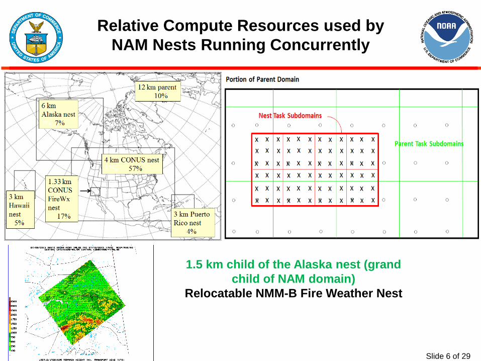
Slide 6 of 29
Relative Compute Resources used by
NAM Nests Running Concurrently
1.5 km child of the Alaska nest (grand
child of NAM domain)
Relocatable NMM-B Fire Weather Nest

Slide 7 of 29
Parent-associated nest vs. freestanding
nest on a global lat/lon (NMMB) or NMMUJ
Freestanding => on a
projection different
from the parent’s
Actively being developed for NMM
in NEMS framework. Courtesy:
Tom Black and Jim Purser
Parent-Oriented Moving Nest on a Corner of a Cubed Sphere
Parent-Oriented Nest with Modified Shape

Slide 8 of 29
• Developed a Hurricane NMMB repository at EMC
– Transitioned HIWPP funded Idealized TC framework to repository
https://svnemc.ncep.noaa.gov/projects/hnmmb
– Currently transitioning Basin-scale HWRF multi-storm initialization into NMMB
Configuration
1) Resolution: 18:06:02km,
61 levels, 2mb model top.
2) Initial TC intensity: 20 m/s
at 1002 mb.
3) Physics package: HWRF
with high-frequency calls
Idealized TC Framework in NMMB
Hurricane Developments in NMMB (EMC-HRD Collaborations supported by HIWPP and R2O/NGGPS)
Slide courtesy: Thiago Quirino, HRD/AOML

Slide 9 of 29
Efficiency and Scalability of NMMB (EMC-HRD Collaborations supported by HIWPP and R2O/NGGPS)
• Evaluating NMMB scalability with 2-way nest
interaction
– Performed various timing experiments: 1-way
and 2-way interaction, varying grid sizes,
multiple nests, and HWRF physics package
– Determined that scalability limitations are
similar to those of HWRF:
• Scalability efficiency levels-off as tile size
reaches ~ 12x12 points
• Halo exchanges and collective MPI calls in
solver are costly
• Frequent physics calls (for high resolution
forecasts) are costly
• Forcing and feedback costs are small when
compared to solver costs (low cost of adding
nests)
• Model code must be further optimized and
physics calls must be reduced to attain further
speed-up beyond the saturation point
– Investigating ways to further reduce cost of 2-
way interaction
Slide courtesy: Thiago Quirino, HRD/AOML

Slide 10 of 29
Evaluation of the Hurricane NMMB (EMC-HRD Collaborations supported by HIWPP and R2O/NGGPS)
• Perform quasi real-time forecasts of Basin-scale NMMB at
18:06:02km resolution for multiple-storms in 2015
– Developed an end-to-end automation system for real-time forecasts
http://storm.aoml.noaa.gov/hnmmb
Slide courtesy: Thiago Quirino, HRD/AOML

Slide 11 of 29
Impact of Two-Way Nesting on Hurricane
Track and Intensity Forecasts from
Operational HWRF
Red lines: one-way nesting
Blue lines: two-way nesting
Dashed lines: from parent domain
Solid lines: from combined domain
track
intensity
bias
For track forecasts, two-way nesting reduces
errors by 5% compared to one-way nesting
For intensity forecasts, two-way nesting provided
significantly better performance compared to
one-way nesting runs. Significant reduction of
negative bias is apparent. Skill improvements
are of the order of 30% in the outer domain and
about 10% in the high-resolution domain.

Slide 12 of 29
Two-Way Nesting Capabilities in GFDL FV3 (Recent developments using HiRAM and FV3)
• Two-way nests in FV3 designed for simultaneous, consistent, coupled
regional and global solutions
• The nested-grid boundary conditions are simple linear interpolation in
space of all variables from the parent grid, and a linear extrapolation in
time, permitting all of the grids to be integrated simultaneously while
allowing the boundary conditions to evolve.
• Boundary conditions for nonhydrostatic simulations are computed using the
same semi-implicit solver as the interior nonhydrostatic solution. The nest-
to-parent interaction is done only for the winds and temperature.
• The parent grid's winds and temperature are completely replaced, using a
vorticity-conserving averaging for the horizontal winds and a spatial
average for temperature and vertical velocity.
Slide courtesy: Lucas Harris, GFDL

Slide 13 of 29
Two-Way Nesting Capabilities in GFDL FV3 (Recent developments using HiRAM and FV3)
• Grid nesting improves small-scale features in idealized baroclinic cyclones
and orographic flows without disrupting the general circulation (Harris and
Lin, 2013).
• Multi-decade comprehensive climate simulations using grid nesting
improved orographic precipitation, hurricane intensity, and monsoon
development (Harris and Lin, 2014).
• Grid nesting efficiently improved the simulation of nocturnal Great Plains
convection, intense Atlantic hurricanes, and severe thunderstorm
outbreaks. (Harris and Lin, 2014).
• Each grid is integrated simultaneously on its own set of processors,
opening the possibility, in computing environments with many processors,
of running a nested grid in a global simulation with only a minor time
penalty.
Slide courtesy: Lucas Harris, GFDL

Slide 14 of 29
Two-Way Nesting Capabilities in GFDL FV3 (Recent developments using HiRAM and FV3)
Year-long nonhydrostatic HiRAM
simulation using 2005 SSTs, using an 8-
km nest over the tropical Atlantic
Examples of high-resolution
nested grid simulations using
HiRAM and FV3
three-day HiRAM
forecasts of severe
convection during the
Moore, OK tornado
outbreak of May 2013,
in a simulation nesting
down to 1.3 km over
the southern plains
(using HIWPP 3km
global runs)
Slide courtesy: Lucas Harris, GFDL

Slide 15 of 29
Mesh Refinement Capabilities in NCAR
MPAS: Mesh Generation
(1) User-specified density function
(2) Lloyd’s method
1. Begin with any set of initial
points (the generating point
set)
2. Construct a Voronoi
diagram for the set
3. Locate the mass centroid of
each Voronoi cell
4. Move each generating point
to the mass centroid of its
Voronoi cell
5. Repeat 2-4 to convergence
Slide courtesy: Bill Skamarock, NCAR

Slide 16 of 29
North
American
refinement
MPAS: Mesh Generation: Lloyd’s Method
(iterative, using a user supplied density function)
Equatorial
refinement
Andes
refinement
Slide courtesy: Bill Skamarock, NCAR

Slide 17 of 29
MPAS: Global Mesh and Integration Options
Global Uniform Mesh Global Variable Resolution Mesh Regional Mesh - driven by
(1) previous global MPAS run (no spatial interpolation needed!)
(2) other global model run
(3) analyses
Voronoi meshes allows us to cleanly incorporate both
downscaling and upscaling effects (avoiding the problems in
traditional grid nesting) & to assess the accuracy of the
traditional downscaling approaches used in regional climate
and NWP applications.
Slide courtesy: Bill Skamarock, NCAR

Slide 18 of 29
HWT Spring Experiment
5-day forecasts, 50 – 3 km mesh 1-
31 May 2015
PECAN field campaign
3-day forecasts, 15 – 3 km mesh
7 June – 15 July 2015
MPAS Forecast Experiments with Variable-
Resolution Meshes
Slide courtesy: Bill Skamarock, NCAR

Slide 19 of 29
MPAS-Atmosphere 2013-2014-2015
Tropical Cyclone Forecast Experiments
daily 10-day forecasts during the NH tropical cyclone season
Forecast Experiments with Variable-
Resolution Meshes
Western Pacific basin mesh Eastern Pacific basin mesh Atlantic basin mesh
Slide courtesy: Bill Skamarock, NCAR

Slide 20 of 29
Mesh Examples for NEPTUNE/NUMA
NEPTUNE: Navy Environmental Prediction sysTem Utilizing the NUMA2 corE
NUMA: Nonhydrostatic Unified Model of the Atmosphere (F. Giraldo NPS)
NEPTUNE-NUMA has a very flexible core that allows for static mesh
refinement, cubed-sphere, icosahedral meshes, limited area meshes.
Slide courtesy: Jim Doyle, NRL

Slide 21 of 29
NEPTUNE-NUMA Adaptive Mesh Refinement
•Non-conforming adaptive mesh
refinement (AMR) capability in
NEPTUNE will increase efficiency
•Possible applications: tropical
cyclones, dispersion, urban,
coastal, severe storms…
E. Hendricks
2-D Rising Bubble 2-D Vortex
Kopera and Giraldo JCP (2013) Slide courtesy: Jim Doyle, NRL

Slide 22 of 29
Mesh Refinement Options in NIM
NIM uses a generalized grid
structure with an arbitrary
number of sides from 4-7
(super-icosahedral) which will
accommodate the stretched
icos grid that the MPAS grid-
generator can produce.
NIM can run with the
stretched grid for nesting
NIM can also set up a formal
regional nesting capability,
similar to that envisioned for
MPAS
Slide courtesy: Stan Benjamin, ESRL

Slide 23 of 29
Variable Resolution (Nesting or Mesh
Refinement, 1-way or 2-way) Capabilities for
NGGPS: Phase 2 Testing
• Purpose is to demonstrate a baseline capability to provide enhanced resolution over
certain regions of interest, especially for hurricanes and convective systems
• Approximately a 4:1 variation in horizontal resolution (3 km in the vicinity of
convective systems including hurricanes, up to 13 km in the far field) Individual
groups can configure as they choose, using fixed or moving high-resolution region, 1-
way or 2-way nests
• Groups will be required to run the test with GFS physics, but may submit
supplementary tests with their own physics (since ‘scale-aware’ physics may be
desirable in this case)
• HWRF physics for hurricanes and HRRR physics for convective systems are
needed for evaluating high-resolution simulations for global model with high-
resolution nests.
• Should be NEMS compliant for future expansion to Unified Global Modeling
System
Slide 22 of 31
Slide 24 of 29
NGGPS Nesting Team Milestones and
Deliverables (2015-2016)
• NCEP/AOML: – Transition HIWPP funded upgrades, including ports of the HWRF nest movement
algorithm and idealized tropical cyclone framework into NEMS repository
– Determine the efficiency and scalability of NMMB/NEMS with two-way interactive nests
– Develop, test, and evaluate generalized grid-independent interpolation techniques for
free-standing nests in the NMMB/NEMS framework
– Test and evaluate the basin-scale HWRF multi-storm initialization in NMMB/NEMS
framework and assess potential for demonstrating the initialization real-time in FY16
and implementing it in FY17
– Implement scale-aware physics in NMMB for multi-storm multiple nest applications
– Develop preliminary capabilities for atmosphere-land-ocean-wave coupled system for
hurricane applications
– Proof of concept of global to local scale modeling system for hurricane predictions
• GFDL: – Subseasonal hurricane prediction in a prototype variable-resolution global NGGPS
model
• PSU: – Advancing Storm-Scale Forecasts over Nested Domains for High-Impact Weather

Slide 25 of 29
• Continue to increase resolution of nests that can operate
at cloud-resolving scales
• Couple nesting capability with more components as
added to NEMS
• Demonstrate global models operating at cloud resolving
scales with high-resolution nests for more accurate
forecasts of significant weather events
• Develop advanced post-processing techniques,
products, verification and diagnostic tools.
• Close interactions with other NGGPS atmospheric
dynamics, physics, data assimilation, overarching
system, software architecture and engineering teams
NGGPS Nesting Team Long-Term
Objectives

Slide 26 of 29
Whole
Atm
osp
here
Mo
de
l Unified Global Model
Application
=
Ensemble
+
Reanalysis
+
Reforecast
NGGPS
Unified Global Coupled Model
(with two-way interactive nests)
“GFS” “GEFS” “CFS”
Actionable
weather
Week 1
through 4-6
Seasonal &
annual
1 y 2 y 4 y Update cycle
3 y 20-25 y 1979 - present Reanalysis
6h 6-24h ??? cycling
WCOSS WCOSS WCOSS ? where

Slide 27 of 29
• Strategic development approach
– Are the generalized nesting techniques truly independent
of choice of NGGPS dycore(s)?
– How scalable and efficient will be the global models with
two-way interactive nests for operational considerations?
(interactions with overarching system/software
architecture and engineering teams)
– Need for developing appropriate physics and initialization
techniques (interactions with atmospheric physics and
data assimilation teams)
– Need for developing advanced diagnostic and verification
tools for evaluating truly non-hydrostatic model forecasts
at cloud resolving scales
NGGPS Nesting/Conevctive Systems
Team Approach

Slide 28 of 29
• Now that we know of the choice of NGGPS global
dycores (FV3 or MPAS)
– Take advantage of already developed (and ongoing
developmental) work in the HWRF and NMMB/NEMS
systems
– Accelerate design and development of efficient two-way
interactive nests in FV3 and moveable mesh refinement
techniques in MPAS
– Future systems should have genesis tracker in the global
domain so we know when to spawn a new nest for a new
storm. Nests' resources have to be able to be "held in
reserve" for when a nest is activated (or re-activated) for a
new storm
Near term Challenges

Slide 29 of 29
Questions?


