Embed Size (px)
Citation preview

41Natural Inquirer • Number 18
Caribbean Cruise:
Examining the Amount and Quality of Organic Matter Over Time From Two Caribbean Watersheds
Examining the Amount and Quality of Organic Matter Over Time From Two Caribbean Watersheds
Photo courtesy of Tamara Heartsill Scalley

42Freshwater Edition, http://www.naturalinquirer.org
Meet the Scientists
Dr. Tamara Heartsill Scalley, Ecologist: One of my favorite experiences was sampling for aquatic fauna in the headwater streams at the highest elevations of the Luquillo (lü kē ō) Experimental Forest . The Elfin Cloud Forests have many small streams . Every surface is dripping wet, covered in all kinds of bryophytes, and the air is cool and humid . These tiny streams have small pools where the modified minnow traps that we used for sampling barely fit . The streams were full of life—with very high densities of filter feeder shrimp such as Atya lanipes .
These streams were the headwaters where streams first emerge from the ground at the highest elevation possible in the forest (figure 1) . It was a pleasant surprise, because
we did not expect many shrimp to be in those pools at the top of the mountain where the river system begins . These shrimp are diadromous (dī a drə məs) . Diadromous means that they came up the mountain by swimming upstream from the coast, where they were in the ocean saltwater . The shrimp swim and crawl to the highest elevation possible in this mountain stream system .
Figure 1. Observe the change in elevation . Illustration by Stephanie Pfeiffer .
Mr. Samuel Moya, Biologist: My favorite science experience is installing new scientific equipment and sensors on experimental sites . New sensors allow me to see more accurate results using graphics and statistical methods .
t
t
t
43Natural Inquirer • Number 18
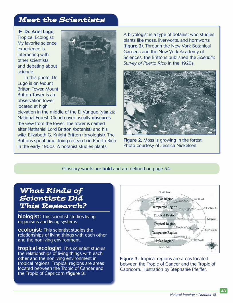
Meet the ScientistsDr. Ariel Lugo,
Tropical Ecologist: My favorite science experience is interacting with other scientists and debating about science .
In this photo, Dr . Lugo is on Mount Britton Tower . Mount Britton Tower is an observation tower located at high elevation in the middle of the El Yunque (yün kā) National Forest . Cloud cover usually obscures the view from the tower . The tower is named after Nathaniel Lord Britton (botanist) and his wife, Elizabeth G . Knight Britton (bryologist) . The Brittons spent time doing research in Puerto Rico in the early 1900s . A botanist studies plants .
A bryologist is a type of botanist who studies plants like moss, liverworts, and hornworts (figure 2) . Through the New York Botanical Gardens and the New York Academy of Sciences, the Brittons published the Scientific Survey of Puerto Rico in the 1920s .
Figure 2. Moss is growing in the forest . Photo courtesy of Jessica Nickelsen .
Glossary words are bold and are defined on page 54 .
What Kinds of Scientists Did This Research?
biologist: This scientist studies living organisms and living systems .
ecologist: This scientist studies the relationships of living things with each other and the nonliving environment .
tropical ecologist: This scientist studies the relationships of living things with each other and the nonliving environment in tropical regions . Tropical regions are areas located between the Tropic of Cancer and the Tropic of Capricorn (figure 3) .
Figure 3. Tropical regions are areas located between the Tropic of Cancer and the Tropic of Capricorn . Illustration by Stephanie Pfeiffer .
t

44Freshwater Edition, http://www.naturalinquirer.org
Thinking About Science
Sometimes it is useful for scientists to study something over a long period of time. The Forest Service created 81 experimental forests and ranges with this idea in mind (figure 4). The Forest Service started setting up these experimental areas in 1908. Most of the experimental areas are at least 50 years old. These areas are useful for scientists because they provide scientists with the opportunity to observe and conduct experiments in an area over a long period of time.
When scientists are able to gather information over several years, they can gain a better idea of what is happening in the area. For example,
think about a time in school when a student does not give his or her best effort with schoolwork. Then the student has several years in which he or she gives his or her best effort. If the student were given a choice to be evaluated over the short time period when they didn’t give their best effort or the longer time period, the student would want to be judged on the schoolwork done over the longer period of time. The longer time period would provide better information about the student. Similarly, scientists gain a deeper understanding of what is happening when they can review several years of data. Scientists are also able to identify trends in the data this way. In this article, you will learn about an experimental forest located in Puerto Rico (figure 5).
Figure 4. Experimental forests and ranges can be found throughout the United States . Find the one closest to where you live . Map by Carey Burda .

45Natural Inquirer • Number 18
Figure 5. Puerto Rico is a territory of the United States located in the northeast Caribbean Sea . Map by Carey Burda .
Number Crunchesb ThefirstexperimentalforestwasFort
ValleyExperimentalForestinArizona.Itwasestablishedin1908.Howmanyyearsoldistheexperimentalforesttoday?Howmanydecadesoldistheexperimentalforest?
Thinking About the Environment
A watershed is the area that drains to a common waterway, such as a stream, lake, estuary, wetland, aquifer, or even the ocean (figure 6). Understanding the activities that occur within watersheds and the location of the watershed is important. The activities and location can affect the watershed’s water quality.
Figure 6. A watershed is the area that drains to a common waterway, such as a stream, lake, estuary, wetland, aquifer, or even the ocean . Illustration by Stephanie Pfeiffer .

46Freshwater Edition, http://www.naturalinquirer.org
In this research, scientists studied two watersheds in Puerto Rico. The watersheds are located in tropical forests. Tropical forests are unique because they are located near the Equator (figure 7). These forests have a high degree of biodiversity and are characterized by a lack of a winter and the occurrence of only two seasons: a wet season and a dry season. In particular, the drainage areas for the watersheds the scientists studied are located in a tabonuco (tä bə nü kō) forest. This type of forest has tall trees and very little light reaches the forest floor. The tabonuco tree (Dacryodes excelsa) dominates the tabonuco forest. The tabonuco tree can grow up to 100 feet tall (figures 8a and 8b).
Figure 7. The Equator is an invisible line around the middle of planet Earth . It is located at zero degrees latitude . The Equator divides the planet into the Northern and Southern Hemispheres . Illustration by Stephanie Pfeiffer .
Figure 8a. The tabonuco tree can grow up to 100 feet tall . In Puerto Rico, the tabonuco tree is found mostly in lower elevations of mountainous areas . Photo courtesy of Jerry Bauer .
Figure 8b. The tabonuco tree oozes sap . Photo courtesy of Jerry Bauer .
Number Crunchb Howtallcanthetabonucotreegrowinmeters?(Hint:1foot=0.3048meters.)

47Natural Inquirer • Number 18
IntroductionThe scientists chose to study two of the
Bisley Experimental Watersheds in the Luquillo Experimental Forest (figure 9). Luquillo Experimental Forest shares its boundaries with El Yunque (ū(ng) kā) National Forest. Because the watersheds are located within the Luquillo Experimental Forest, the scientists could observe and record how things changed over a long period of time. For this research, the scientists studied particulate organic matter (POM).
POM consists of small pieces of twigs, leaves, soil, and other items found in the water (figure 10). POM measurements are important for several reasons. For example, POM is a source of food and energy for many animals. POM keeps some environmental pollutants out of the water by binding heavy metals and pesticides. POM also serves other roles in an ecosystem such as being an important part of the food web. POM is a part of the decomposition process of the food web (figure 11).
In this research, the scientists examined the amount and types of a particular type of POM called coarse particulate organic matter (CPOM). CPOM is the pieces of organic
material that falls into or is carried into the river. CPOM is generally greater than 1 millimeter (mm) in size. Examples of CPOM are leaves, sticks, and other pieces of plant material. Because CPOM is an important component of an ecosystem and food webs, the scientists wanted to figure out how the amount and quality of CPOM changed over a period of time.
Figure 10. Particulate organic matter (POM) is an important component of an ecosystem and the food web . Photo courtesy of Babs McDonald .
Reflection Sectionb Inyourownwords,whatisthequestionthe
scientistswantedtoanswerinthisstudy?
b Thescientistsstudiedtwowatershedsintheexperimentalforest.Whatisonereasonthescientistswantedtostudytwowatershedsinsteadofonlyonewatershed?
Figure 9. Bisley Experimental Watersheds are located in the Luquillo Experimental Forest . Map by Carey Burda .
Number Crunchb CPOMisgenerallygreaterthan1mminsize.
Is1mmsmallerorlargerthan1inch?Howdoyouknow?

48Freshwater Edition, http://www.naturalinquirer.org
Figure 11. Particulate organic matter (POM) is part of the decomposition process of the food web . Illustration by Stephanie Pfeiffer .
MethodsThe scientists collected data from the two
watersheds from 1987 to 2005. The scientists collected mean annual rainfall, size of watershed area, stream channel length, as well as dates of hurricanes and other natural disturbances, such as drought (figure 12).
The scientists wanted to know how much CPOM was being exported from the watersheds. After CPOM is in the water, it undergoes some amount of decomposition. The amount that actually leaves the watershed is the amount that is exported. From 1987 to 2005, scientists collected CPOM that was trapped in metal mesh traps that they placed in the streams.
The scientists collected CPOM every other Tuesday and following large storms. The metal
mesh traps were placed across the stream channels (figure 13). Scientists tested several mesh traps and sizes from 1987 to 1989. These test traps broke during periods of high water flow. Since 1989, however, the traps the scientists designed did not break. These traps recorded accurate measurements of CPOM by collecting all the CPOM going into the trap.
The scientists also completed chemical analysis on some of the samples to see what kinds of elements were in the CPOM. Elements are important to both living and nonliving things. For example, approximately 96 percent of the human body is made up of four elements: carbon, oxygen, hydrogen, and nitrogen. In this study, the scientists measured elements such as carbon, nitrogen, phosphorus, potassium, and calcium in the CPOM.

49Natural Inquirer • Number 18
Figure 12. A lot of data change over time . In this graph, you can see what happened to the mean annual rainfall at the study site between 1988 and 2008 . Illustration by Stephanie Pfeiffer .
Figure 13. Mesh traps were placed across the stream channels to collect coarse particulate organic matter (CPOM) . Photo courtesy of Tamara Heartsill Scalley .

50Freshwater Edition, http://www.naturalinquirer.org
The Periodic Table and Symbols
The periodic table (figure 14) is a table that arranges the chemical elements by
atomic number . Each element has a letter or several letters that identify it in a simpler way and is called a symbol . For example, the symbol for carbon is C and the symbol
for oxygen is O . Look at the periodic table and find the symbols for the elements the scientist studied: nitrogen, phosphorus, potassium, calcium, aluminum, magnesium, iron, and manganese .
Figure 14. This table is a shortened form of the periodic table of elements . For a full table, search the Internet for “periodic element table” or look for it in your science book . The complete periodic table contains 118 elements .
Reflection Sectionb ThescientistscollectedCPOMafterlargestorms.
Whydoyouthinkthesecollectionswereagoodidea?
b ThescientistshadtotestseveraldifferenttypesofmetalmeshtrapstocollecttheCPOMuntiltheyfoundadesignthatworked.Thinkofatimethatyouhavetriedtomakesomethingordosomethinganditdidn’twork.Whatdidyoudo?Whataresomecharacteristicsthatyouthinkareimportantforscientiststohaveinordertoovercomeobstacles?(Hint:TakealookatsomeoftheNaturalInquirerscientistcardsathttp://www.naturalinquirer.org/scientists-v-92.html.Lookatthebackofthecardsandreadaboutimportantscientistcharacteristics.Seeifyouthinkanyofthosecharacteristicsapplytothissituation.)
FindingsDuring the 18-year study period,
the scientists found several things. The highest CPOM export through the watershed occurred before and during Hurricane Hugo. The scientists found that other tropical storms and hurricanes after Hurricane Hugo did not create as much CPOM export as during the time of Hurricane Hugo.
Relatively high exports of CPOM were recorded from 1995 to 2000 (figure 15). The greatest export of leaves (which are part of CPOM) occurred during April, May, and September. These months have the most intense rain showers and the greatest number of plants with falling leaves. During this time, the leaves

51Natural Inquirer • Number 18
Figure 15. Scientists measured coarse particulate organic matter (CPOM) exports from 1995 to 2000 . What do you notice about CPOM export during this time? Graph by Stephanie Pfeiffer .
are mostly falling because of storms, wind, and rain, and they are still green when they fall. Therefore, these leaves have different nutrients and different chemical composition than leaves that fall in the dry season from natural aging.
Low CPOM export occurred during 1990–1991, 1993–1994, and 2000–2002. The lowest amounts of CPOM export were during times of drought. The months of December, January, and February also show low CPOM exports.
Watershed 1 had higher values of potassium than watershed 2. Watershed 2 had higher levels of calcium, magnesium, aluminum, and iron. The scientists found no difference between the two watersheds for levels of nitrogen, phosphorus, and manganese. The scientists thought that the types of leaves and the amount of decay that the leaves had undergone may have affected the elements they found in the watersheds.
Reflection Sectionb CPOMexportwaslowestduringtimesofdrought.Thinkaboutthestreamandthe
surroundingenvironmentduringthesetimes.BrainstormsomeideasastowhyyouthinkCPOMexportcouldhavebeenlow.Youmaywanttoresearchoneofyourideastoseewhatyoucanfindoutaboutit.
b December,January,andFebruaryhadlowCPOMexport.Whydoyouthinkthislowlevelmayhaveoccurred?

52Freshwater Edition, http://www.naturalinquirer.org
Hurricane Hugo
Hurricane Hugo (figure 16), which made landfall in September
1989, created some of the highest stormtide heights that had ever been recorded on the east coast of the United States . Hugo was a category 5 hurricane in the Atlantic Ocean and then became a category 4 storm that went through the Caribbean . Hurricane Hugo had maximum sustained winds of 135 to 140 miles per hour . During that time, Hugo was the strongest storm to hit the United States within a 20-year period, and it created approximately $7 billion ($7,000,000,000) in damage (figure 17) . To learn more, visit http://www .weather .gov/chs/HurricaneHugo-Sep1989 .
The Saffir-Simpson Hurricane Wind Scale is a 1-to-5 rating based on a hurricane’s sustained wind speed (figure 18) . The National Oceanic and Atmospheric Administration explains that “this scale estimates potential property damage . Hurricanes reaching Category 3 and higher are considered major hurricanes because of their potential for significant loss of life and damage . Category 1 and 2 storms are still dangerous, however, and require preventative measures .”
Figure 16. Hurricane Hugo . Photo courtesy of National Oceanic and Atmospheric Administration .
Figure 17. Pre- and post-Hugo photos at Folly Beach, South Carolina . Photos courtesy of National Oceanic and Atmospheric Administration .
Pre-Hugo
Post-Hugo

53Natural Inquirer • Number 18
Category Sustained Winds Types of Damage Due to Hurricane Winds
1 74–95 mph64–82 kt119–153 km/h
Very dangerous winds will produce some damage: Well-constructed frame homes could have damage to roof, shingles, vinyl siding, and gutters . Large branches of trees will snap and shallowly rooted trees may be toppled . Extensive damage to power lines and poles likely will result in power outages that could last a few to several days .
2 96–110 mph83–95 kt154–177 km/h
Extremely dangerous winds will cause extensive damage: Well-constructed frame homes could sustain major roof and siding damage . Many shallowly rooted trees will be snapped or uprooted and block numerous roads . Near-total power loss is expected with outages that could last from several days to weeks .
3 (major) 111–129 mph96–112 kt178–208 km/h
Devastating damage will occur: Well-built framed homes may incur major damage or removal of roof decking and gable ends . Many trees will be snapped or uprooted, blocking numerous roads . Electricity and water will be unavailable for several days to weeks after the storm passes .
4 (major) 130–156 mph113–136 kt209–251 km/h
Catastrophic damage will occur: Well-built framed homes can sustain severe damage with loss of most of the roof structure and/or some exterior walls . Most trees will be snapped or uprooted and power poles downed . Fallen trees and power poles will isolate residential areas . Power outages will last weeks to possibly months . Most of the area will be uninhabitable for weeks or months .
5 (major) 157 mph or higher137 kt or higher252 km/h or higher
Catastrophic damage will occur: A high percentage of framed homes will be destroyed, with total roof failure and wall collapse . Fallen trees and power poles will isolate residential areas . Power outages will last for weeks to possibly months . Most of the area will be uninhabitable for weeks or months .
mph = miles per hour . kt = knots . km/h= kilometers per hour .
Figure 18. The Saffir-Simpson Hurricane Wind scale . Courtesy of the National Oceanic and Atmospheric Administration .
DiscussionThe export of CPOM generally followed a
seasonal pattern that was a combination of the monthly rainfall pattern and seasonal patterns for leaves falling from plants and trees. The scientists found that one of the greatest events of CPOM export was during Hurricane Hugo. The scientists also found that tropical storms and hurricanes after Hurricane Hugo did not create as much CPOM as during the time of Hurricane Hugo.
The scientists believe that this finding has to do with the fact that, during Hurricane Hugo, the forest was more mature. A more mature forest means that it is an older forest with larger trees and more growth. After Hurricane Hugo came through, parts of the forest were destroyed and fewer large trees remained. When tropical storms or other hurricanes came through the area after Hurricane Hugo, less

54Freshwater Edition, http://www.naturalinquirer.org
organic material was available to fall and export into the streams. Therefore, the frequency and intensity of hurricanes and tropical storms, along with the age of the forest, had a measurable effect on the export of CPOM through the watersheds.
Reflection Sectionb Inyourownwords,whatdidthescientistslearnfrom
theirstudy?
b Whyarenaturaldisastersandotherlargeweathereventsimportanttostudy?Whatinformationcantheyprovideforthefuturemanagementofthenaturalsystems?
Glossary analysis (ə na lə səs): A careful study of something to learn about its parts, what they do, and how they are related to each other .
biodiversity (bī ō də vər sə tē): The existence of many different kinds of plants and animals in an environment .
bryophyte (brī ə f īt): Any of a division (Bryophyta) of nonflowering plants comprising the mosses, liverworts, and hornworts .
coarse particulate organic matter (CPOM) (kȯrs pär ti kyə lət ȯr ga nik ma tər): CPOM is the pieces of organic material that falls into or is carried into a river . CPOM is generally greater than 1 millimeter (mm) in size . Examples of CPOM are leaves, sticks, and other pieces of plant material .
decay (di kā): To break down, rot, or undergo decomposition .
decomposition (dē kəm pə zi shən): The slow destruction of something (such as dead plants and the bodies of dead animals) by natural processes, chemicals, etc .
dominate (dä mə nāt): To have a prominent place or position .
drainage (drā nij): (1) The act or process of draining something; (2) The act or process of removing water or liquid from a place or thing .
ecosystem (ē kō sis təm): Community of plants and animal species interacting with one another and with the nonliving environment .
export (ek spȯrt): To carry away .
fauna (fä nə): All the animals that live in a particular area, time period, or environment .
frequency (frē kwən(t) sē): The number of times that something happens during a particular period .
obscure (äb skyu̇r): Not clearly seen or easily distinguished .
organic (ȯr ga nik): Of, relating to, or obtained from living things .
pesticide (pes tə sīd): A substance that is used to kill animals or insects that eat plants or crops .
statistical (stə tis ti kəl): Based on statistics, a branch of mathematics that deals with analyzing and interpreting data .
sustain (sə stān): Continuing for an extended period .
trend (trend): A general direction of change .
Accented syllables are in bold . Marks and definitions are from http://www .merriam-webster . com . Definitions are limited to the word’s meaning in the article .
Adapted from Heartsill Scalley, T.; Scatena, F.N.; Moya, S.; Lugo, A.E. 2012. Long-term dynamics of organic matter and elements exported as coarse particulates from two Caribbean montane watersheds. Journal of Tropical Ecology. 28: 127–139. http://www.treesearch.fs.fed.us/pubs/41610.

55Natural Inquirer • Number 18
FACTivity
Time NeededOne class period
Materials(for each student or group of students)• Pencil• Graph paper• “Caribbean Cruise” article in this
Natural Inquirer edition
The question you will answer in this FACTivity is: What can you learn from data about gage height and streamflow for a stream for an extended period of time?
MethodsIn the article you just read, the scientists
examined a variety of different types of data from the Bisley Experimental Watersheds
in the Luquillo Experimental Forest . The table of data provided in the following table is from the Rio Sabana in Luquillo Experimental Forest and El Yunque National Forest . The data have been collected for 33 years . The gage height is the height of the water above zero on the water gage . A water gage is an instrument used to find the depth or quantity of water or to indicate its surface height . Streamflow is the water released from a stream . Streamflow is measured in cubic feet per second . Examine the data in table 1 . On the graph paper provided (on page 123), create a graph for either the gage height data or the streamflow data (figure 19) .
Figure 19. A sample graph of the peak streamflow data from Rio Sabana . Graph courtesy of the U .S . Geological Survey .

56Freshwater Edition, http://www.naturalinquirer.org
Year Date Gage Height (feet) Streamflow (cubic feet per second)
1980 May 22, 1980 12 .55 1,760
1981 May 19, 1981 15 .77 4,480
1982 May 10, 1982 18 .17 7,340
1983 Apr . 21, 1983 19 .35 9,010
1984 Dec . 02, 1983 12 .50 1,730
1985 May 17, 1985 14 .73 3,470
1986 May 13, 1986 13 .27 2,260
1987 May 25, 1987 14 .16 2,970
1988 Nov . 27, 1987 15 .23 3,940
1989 Sep . 18, 1989 18 .77 8,170
1990 Aug . 13, 1990 16 .08 4,660
1991 Jun . 30, 1991 15 .80 4,520
1992 Jan . 05, 1992 19 .74 9,600
1993 Dec . 29, 1992 16 .11 4,840
1994 Feb . 19, 1994 14 .00 2,830
1995 Nov . 07, 1994 12 .62 1,810
1996 May 13, 1996 15 .64 4,350
1997 Sep . 26, 1997 14 .15 2,960
1998 Sep . 21, 1998 15 .86 4,580
1999 May 08, 1999 14 .56 3,310
2000 Aug . 23, 2000 14 .24 3,030
2001 Aug . 22, 2001 15 .79 4,500
2002 Nov . 09, 2001 13 .91 2,760
2003 Apr . 17, 2003 18 .69 8,050
2004 Sep . 15, 2004 16 .55 5,330
2005 Oct . 29, 2004 15 .41 4,120
2006 Apr . 05, 2006 13 .07 2,120
2007 Oct . 20, 2006 13 .35 2,320
2008 Apr . 27, 2008 18 .99 8,480
2009 Jun . 12, 2009 13 .67 2,570
2010 Apr . 13, 2010 15 .58 4,290
2011 Aug . 22, 2011 14 .50 3,260
2012 May 10, 2012 11 .82 1,300
2013 May 10, 2013 12 .89 1,990
Table 1. Gage height and streamflow data from Rio Sabana in Puerto Rico . Data courtesy of U .S . Geological Survey .

57Natural Inquirer • Number 18
After you have created the graph, compare the data over the 33-year time period .
• Circle any points that seem to be very high or very low .
• Name at least two things from the data that seem important . Why do you think the data from these two times may be important? What do you think the data from these times may indicate?
• How did creating a graph from the data help you to analyze and understand the data?
• Share and discuss your results with your classmates . Did they notice similar points in the data? How were your graphs and analysis of the graphs similar and different?
Natural Inquirer Connections
You may want to reference these Natural Inquirer articles for additional information
and FACTivities:
• “Leaf Me Alone” in the Tropical Forest edition of Natural Inquirer .
• “Don’t Litter the Stream” in the Hawai`i-Pacific Islands edition of Natural Inquirer .
• “I’ll Huff and I’ll Puff and I’ll Blow Your Trees Down!” in the Tropical Forest edition of Natural Inquirer .
• “Swimming Upstream Without a Ladder” in the Tropical Forest edition of Natural Inquirer .
These articles, along with others, can be found at http://www .naturalinquirer .org/all-issues .html .
What’s in a Word?
One of the many questions that people have asked from time to time is the
spelling of the word “streamgage” versus spelling it with a “u” as in “streamgauge .” Page 50 of the U .S . Geological Survey report, A History of the Water Resources Branch, U.S. Geological Survey: Volume I, From Predecessor Surveys to June 30, 1919 (http://on .doi .gov/USGSWaterHistory) includes a reference giving credit to the change in spelling to F .H . Newell around 1892 . The author wrote:
At about this time, F .H . Newell adopted the spelling “gage” instead of “gauge .” As he informed the writer, “gage” was the Saxon spelling before the “u” was inserted as a result of Norman influence on the language .
Ever since then, the U .S . Geological Survey has spelled the word without the “u .”
Web ResourcesInternational Institute of Tropical Forestry http://www.fs.usda.gov/iitf/
U.S. Geological Survey Water Data for Rio Sabanahttp://waterdata.usgs.gov/nwis/inventory/?site_no=50067000&agency_cd=USGS
A Distance Learning Adventure: America’s Rainforests—Caribbean National Forest/Luquillo Experimental Foresthttp://rainforests.pwnet.org/americas_rainforests/caribbean.php
El Yunque National Foresthttp://www.fs.usda.gov/elyunque
Luquillo Long-Term Ecological Research Programhttp://luq.lternet.edu/
Tabonuco Treeshttp://www.na.fs.fed.us/pubs/silvics_manual/volume_2/dacryodes/excelsa.htm
University of California Museum of Paleontology: Tropical Forestshttp://www.ucmp.berkeley.edu/exhibits/biomes/forests.php#tropical
History of Fort Valley Experimental Forest http://www.foresthistory.org/ASPNET/Places/ResearchSites/FortValley.aspx

![Puerto Rico Area O˜ce B7 Calle Tabonuco, Suite 1105 ... - pr · Puerto Rico Area O˜ce B7 Calle Tabonuco, Suite 1105 Guaynabo, PR 00968 [t] (787) 277-1560 [F] (787) 277-1567 Hon](https://img.dokumen.tips/doc/110x75/5e457a2f345efc11893dcdd4/puerto-rico-area-ooece-b7-calle-tabonuco-suite-1105-pr-puerto-rico-area-ooece.jpg)