Embed Size (px)
Citation preview

Interoperability between Earth Sciences and GIS models: an
holistic approach
Stefano Nativi
Italian National Research Council (Institute of Methodologies for Environmental Analysis)
andUniversity of Florence
Seminar at NCAR and UCAR-UOP-----
Boulder (CO) USA, 27 July 2006

Outline• Context
– Rationale and Objectives– International Initiatives– Standardization Process– Interoperability process among Info communities
• Holistic view of the ES and GIS Domain Models– Model diversities– Models harmonization
• An Implemented Solution• Experimentations
– OGC IE – Regional SDI – EC-funded project
• Conclusions
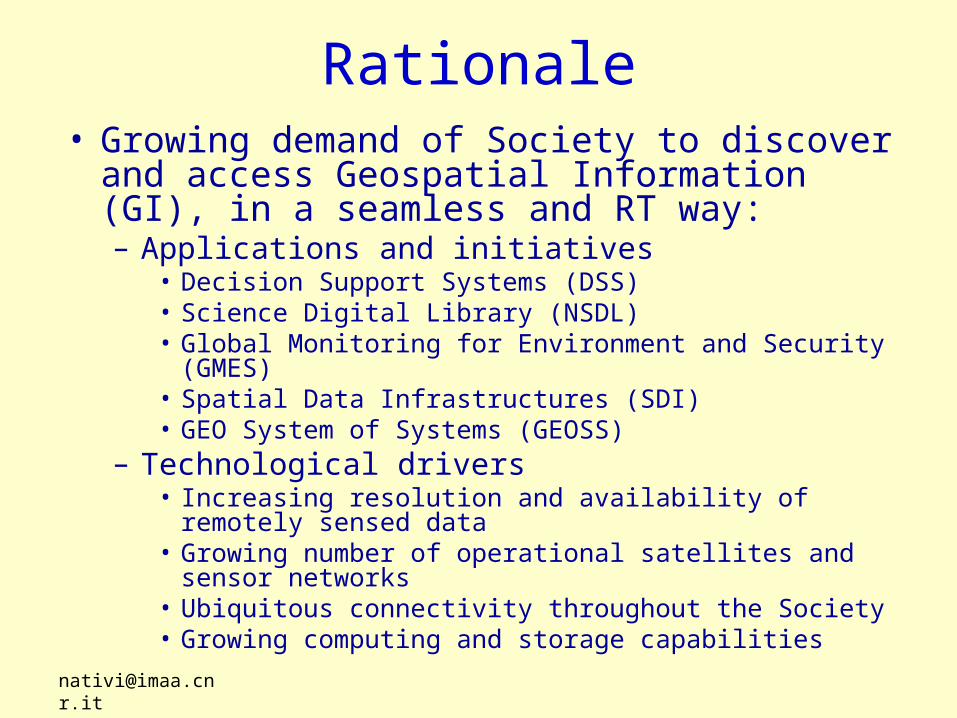
Rationale• Growing demand of Society to discover and
access Geospatial Information (GI), in a seamless and RT way:– Applications and initiatives
• Decision Support Systems (DSS)• Science Digital Library (NSDL)• Global Monitoring for Environment and Security (GMES)• Spatial Data Infrastructures (SDI)• GEO System of Systems (GEOSS)
– Technological drivers• Increasing resolution and availability of remotely sensed
data• Growing number of operational satellites and sensor
networks• Ubiquitous connectivity throughout the Society• Growing computing and storage capabilities

Initiatives and Programmes• GMES (Global Monitoring for Environment & Security)
– to bring data and information providers together with users, ….and make environmental and security-related information available to the people who need it through enhanced or new services
• IST (Information Society Technology -and Media) –Env sector– focus on the future generation of technologies in which computers
and networks will be integrated into the everyday environment, rendering accessible a multitude of services and applications through easy-to-use human interfaces.
• GEOSS (Global Earth Observation System of Systems)– realize a future wherein decisions and actions for the benefit of
human kind are informed via coordinated, comprehensive, and sustained Earth observations. . . The purpose of GEOSS is . . . to improve monitoring of the state of the Earth, increase understanding of Earth processes, and enhance prediction of the behaviour of the Earth system

Initiatives and Programmes• DGIWG (Digital Geospatial Information Working
Group)– have access to compatible geospatial information for joint
operations.
• NSDL (National Science Digital Library)– to enhance science, technology, engineering and
mathematics education through a partnership of digital libraries joined by common technical and organizational frameworks.

Initiatives and Programmes• Spatial Data Infrastructures (Geographic Data
Infrastructures)– INSPIRE (The INfrastructure for SPatial InfoRmation in
Europe )• creation of a European spatial information infrastructure that
delivers to the users integrated spatial information services.
– NSDI (National Spatial Data Infrastructure)• share geographic data among all users could produce
significant savings for data collection and use and enhance decision making
– NFGIS (National Fundamental Geographic Information System)
• provide China a common, basic spatial information system
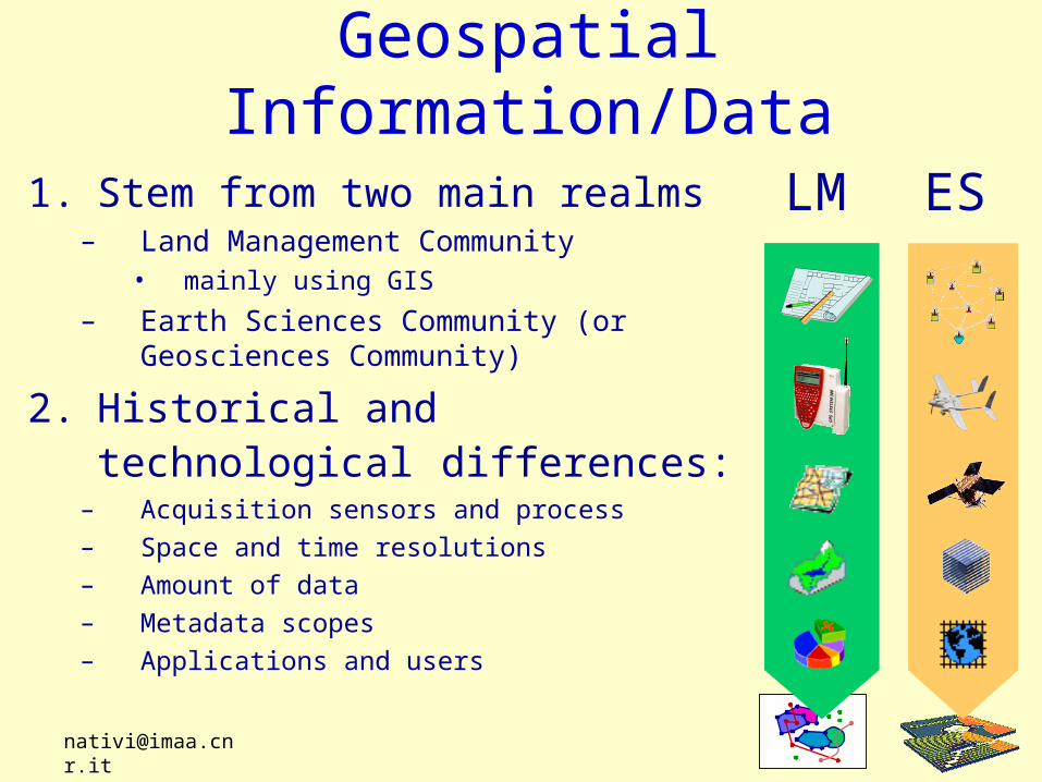
Geospatial Information/Data
1. Stem from two main realms– Land Management Community
• mainly using GIS
– Earth Sciences Community (or Geosciences Community)
2. Historical and technological differences:
– Acquisition sensors and process
– Space and time resolutions
– Amount of data
– Metadata scopes
– Applications and users
ESLM

3. Society platforms and systems are GIS-based4. A GI standardization framework has been defined
for geospatial data interoperability To add ES resources to this picture
• Three main processes
SOCIETY
INFRASTRUCTURES,
PLATFORMS
and SYSTEMS
LM
ES
Geospatial Data
Acquisition and
Encoding
Knowledge Extraction
and Harmonizati
on
Using Standard
Models andInterfaces for
GI Interoperabilit
y
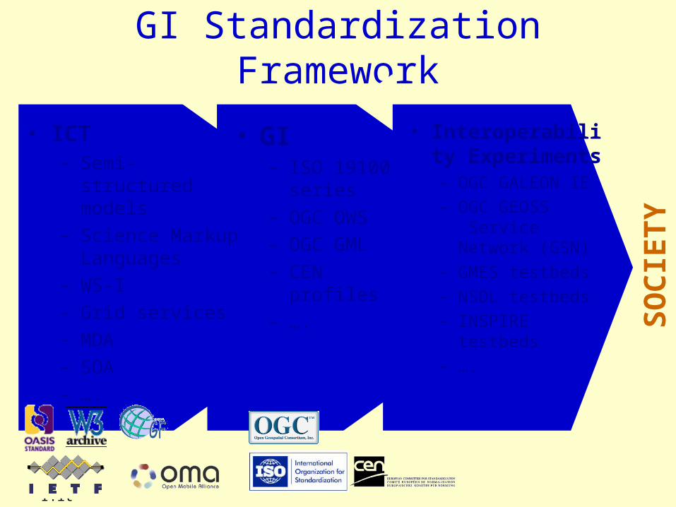
GI Standardization Framework
• GI– ISO 19100
series– OGC OWS– OGC GML– CEN profiles– ….
• ICT– Semi-structured
models– Science Markup
Languages– WS-I – Grid services– MDA– SOA– ….
• Interoperability Experiments– OGC GALEON
IE– OGC GEOSS
Service Network (GSN)
– GMES testbeds– NSDL testbeds– INSPIRE
testbeds– ….
SO
CIE
TY

Main Objective Provide Information Society with an effective, NRT and easy-to-use
fruition of multidimensional Earth Sciences datasets (e.g. 4/5-D)
Geospatial datasetsAcquisition and
Encoding
Knowledge Extraction
and Harmonization
StandardModels andInterfaces
Explicit Semantic level /Interoperability level
SOCIETY
INFRASTRUCTURES,
PLATFORMS
and SYSTEMS

Info Communities Interoperability
• Imply to conceive and implement Info realms interoperability– Data & metadata models– Related services
Earth SciencesInfo Realm
Land ManagementInfo Realm
GISRealm

Geographic Information Realm• Stack of model layers• A couple of general models (see ISO 19100)
– Boundary model– Coverage model
GIS Realm
Mathematics
Geography
Boundary model
Coverage model
Basic discipline models
Geographicinformation models
Topology
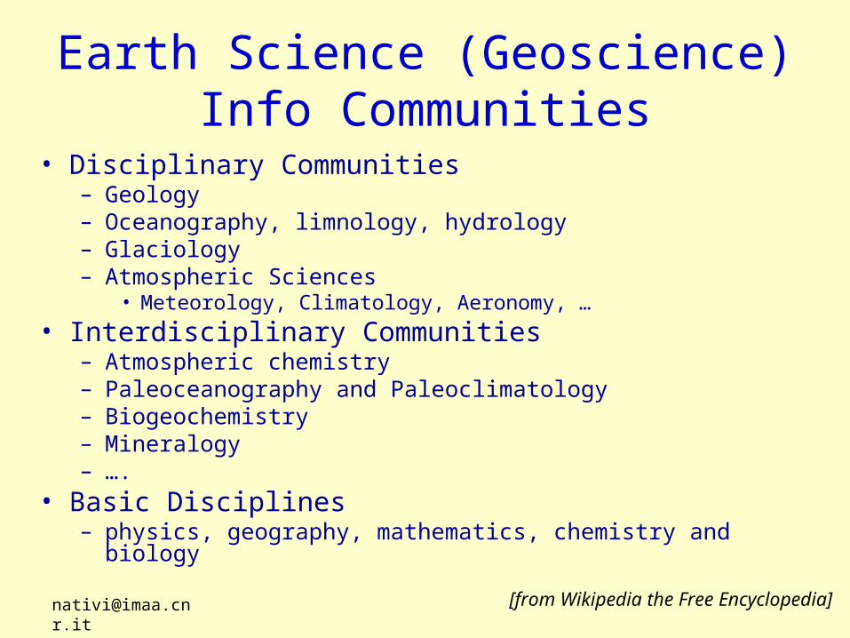
Earth Science (Geoscience) Info Communities
• Disciplinary Communities– Geology– Oceanography, limnology, hydrology– Glaciology– Atmospheric Sciences
• Meteorology, Climatology, Aeronomy, …
• Interdisciplinary Communities– Atmospheric chemistry– Paleoceanography and Paleoclimatology– Biogeochemistry– Mineralogy – ….
• Basic Disciplines– physics, geography, mathematics, chemistry and biology
[from Wikipedia the Free Encyclopedia]

Earth Science (Geoscience) Info Communities
• Disciplinary and Interdisciplinary models
Mathematics
Chemistry Physics Biology Geography Basic discipline
models
Geology
Oceanography
AtmosphericSciences
Glaciology
ES disciplinemodels
Mineralogy
Paleoceanography
AtmosphericChemistry
ES interdisciplinary
models…..
Earth Sciences Info Realm

How to pursue Interoperability? • Holistic approach
– A common interoperability model
• Reductionist approach:– An interoperability model for each discipline
Mathematics
Chemistry Physics Biology Geography
Geology Oceanography
AtmosphericSciences
Glaciology
Mineralogy Paleoceanography
AtmosphericChemistry…..
Earth Sciences Info Realm
GIS RealmIn
tero
pe
rab
ility
M
od
el

How to implement Interoperability?
Object-oriented Resource-oriented
Service-oriented
RPC
Messaging-
passing
O bje ct A
a t t rib u te :T y p e = in it ia lVa lu e
o p e ra t io n (a rg lis t ):re tu rnty p e
Dis
trib
uted
Sys
tem
s
Architectural Styles
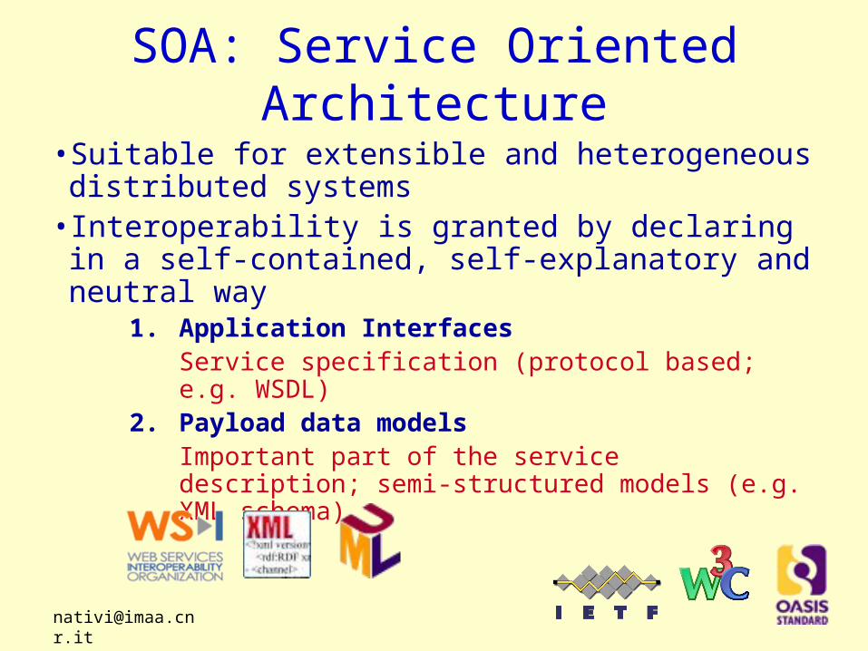
SOA: Service Oriented Architecture
• Suitable for extensible and heterogeneous distributed systems
• Interoperability is granted by declaring in a self-contained, self-explanatory and neutral way
1. Application InterfacesService specification (protocol based; e.g. WSDL)
2. Payload data modelsImportant part of the service description; semi-structured models (e.g. XML schema)
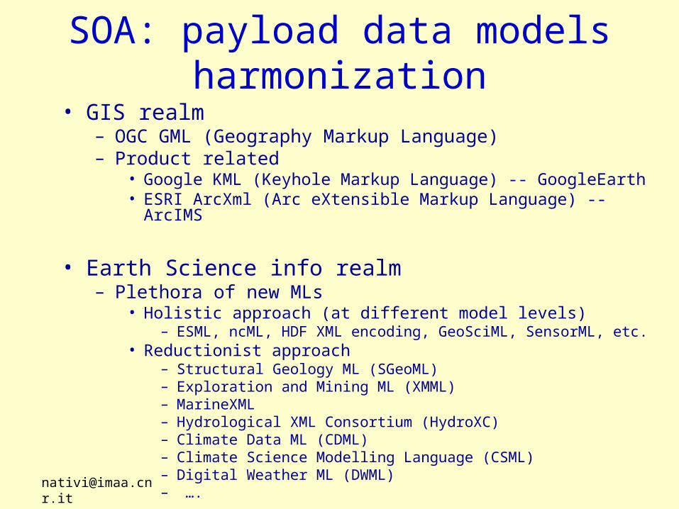
SOA: payload data models harmonization
• GIS realm– OGC GML (Geography Markup Language)– Product related
• Google KML (Keyhole Markup Language) -- GoogleEarth• ESRI ArcXml (Arc eXtensible Markup Language) -- ArcIMS
• Earth Science info realm– Plethora of new MLs
• Holistic approach (at different model levels)– ESML, ncML, HDF XML encoding, GeoSciML, SensorML, etc.
• Reductionist approach– Structural Geology ML (SGeoML)– Exploration and Mining ML (XMML)– MarineXML– Hydrological XML Consortium (HydroXC)– Climate Data ML (CDML)– Climate Science Modelling Language (CSML)– Digital Weather ML (DWML)– ….

SOA: Interface protocols adapters
• GIS realm– OWS (i.e. WMS, WFS, WCS, CS-W, WPS, ….)– Product related
• Google Map and Google Earth service interfaces• ArcIMS service interfaces
• Earth Science info realm– Holistic approach (at different levels)
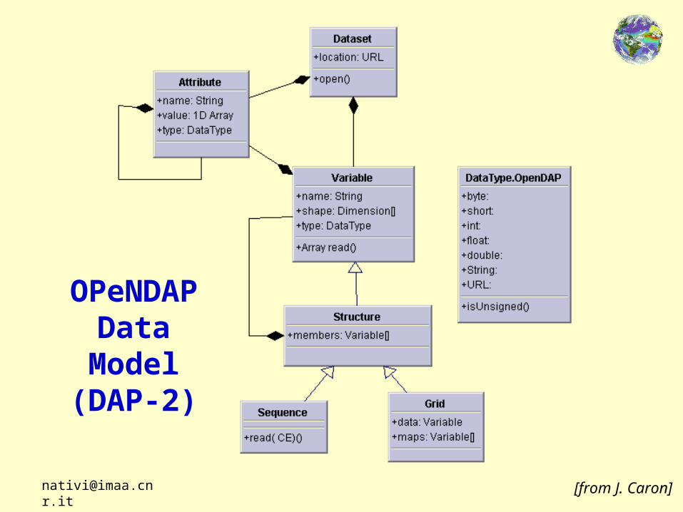
– OPeNDAP, THREDDS catalog service, …
– Reductionist approach– CDI, EOLI, …

Over-simplified Worldviews• To the Geographic Information community, the world
is:– A collection of featuresfeatures (e.g., roads, lakes, plots of land)
with geographic footprints on the Earth (surface).– The featuresfeatures are discrete objectsdiscrete objects described by a set of
characteristics such as a shape/geometryshape/geometry
• To the Earth Science community, the world is:– A set of event observationsobservations described by parametersparameters
(e.g., pressure, temperature, wind speed) which vary as continuous functionscontinuous functions in 3-dimensional space and time.
– The behavior of the parametersparameters in space and time is governed by a set of equations.equations.
[from Ben Domenico]
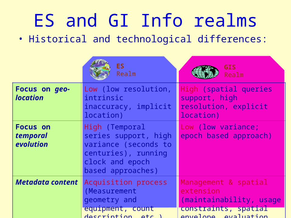
ES and GI Info realms• Historical and technological differences:
Focus on geo-location
Low (low resolution, intrinsic inaccuracy, implicit location)
High (spatial queries support, high resolution, explicit location)
Focus on temporal evolution
High (Temporal series support, high variance (seconds to centuries), running clock and epoch based approaches)
Low (low variance; epoch based approach)
Metadata content Acquisition process (Measurement geometry and equipment, count description, etc.)
Management & spatial extension (maintainability, usage constraints, spatial envelope, evaluation, etc.)
GISRealm
ESRealm

ES and GI Info realms• Historical and technological differences:
Data aggregation levels
Hierarchical tree (multiparameter complex datasets)
Simple trees (time series)
Grid cell aggregations (clusters, regions, topological sets)
Fiber bundles (multichannel satellite imagery)
Dataset Series
Dataset
Features
Data types Multi-dimensional arrays (at least 3-D + time)
Topological features (usually 2-D geometry) referred to a geo-datum
GISRealm
ESRealm

GIS Abstract Data ModelsGeneral feature model
(in both OpenGIS and ISO TC 211 specs)
Feature Feature Topology
Temporal Attr.
Feature Attribute
Spatial Attr.Non-Spatial Attr.Location Attr.
GM (Geometry Model) Object

GIS Abstract Data Models• Simplified schema of ISO 19107 geometry basic types
GM (Geometry Model) Object
GM_Point
GM_Curve GM_Surface GM_Solid
GM_MultiPointGM_CompositePoint

Observ.s Vs. Features: Value-added Chaining
• (Event) Observation – estimate of value of a property for a single
specimen/station/location – data-capture, with metadata concerning procedure, operator, etc
• Feature – object having geometry & values of several different
properties 1. classified object
– snapshot for transport geological map elements 2. object created by human activity
– artefact of investigation borehole, mine, specimen
[from S.Cox Information Standards for EON]
• Coverage – compilation of values of a single property across the domain of
interest – data prepared for analysis/pattern detection

The Coverage concept• Coverage definition
A feature that acts as a function to return one or more feature attribute values for any direct position within its spatiotemporal domain
[ISO 19123]
• A coverage is a special case of (or a subtype of) feature
[The OpenGIS™ Abstract Specification Topic 6: The Coverage Type and its Subtypes].
• An extremely important concept to implement model interoperabilty

Model ES data as Coverage• To explicitly mediate from a ES hyperspatial observation
data model to a GIS coverage data model– To express ES obs. semantics using GIS the Coverage elements
ES dataset GIS coverage
N independent dimensions (i.e. axes) {2, 2+z, 2+z+t} coverage domain dimensions
Set of scalar variables Coverage range-set of values
(t, z, y, x) variable shape (x, y, z, t) fixed range shape
Implicit geo-location metadata Explicit geo-location metadata
Grid geometry non-evenly spaced Grid geometry regularly spaced
etc. etc.

multidimensional Observation
dataset(e.g. 4/5D hypercube)
N-Dimension Coordinate Systems
ES Dataset content
<dimension>,<coordinateSystem><coordinateAxis>
<netcdf type>
explicit/semi-implicit/implicit Geometry
<dimension>,<variable>
0110110011111010101010010101…01101100111
11010101010010101…
Scalar measured quantities
<variable>

2D+elev+timedataset
2D Spatial Coordinate System + elev + time
Range set
GIS coverage content
<_CoordinateSystem>,<coordinateSystem Axis>
<rangeSet> <_Coverage>
explicit/implicit Geometry
Spatial Reference System (SRS)
<gridDomain>,<rectifiedGrid Domain>,<multipointDomain>
<GeographicCRS>

2 Dimension Coordinate System
Implicit/explicit Geometry
Range set
Spatial Reference System (SRS)
2 Dimension Coordinate System
Implicit/explicit Geometry
Range set
Spatial Reference System (SRS)
2 Dimension Coordinate System
Implicit/explicit Geometry
Range set
Spatial Reference System (SRS)
2 Dimension Coordinate System
Implicit/explicit Geometry
Range set
Spatial Reference System (SRS)
The Mediation Process
ES hyperspacedataset(3/4/5D)
2D + elev + time Coverages
2D+elev+time dataset
2D SCS + elev + time
Implicit/explicit Geometry
Range set
Spatial Reference System (SRS)
a Coverage
0110110011111010101010010101…01101100111
11010101010010101…
N-Dimension Coordinate Systems
explicit/semi-implicit/implicit Geometry
Scalar measured quantities ss S
SSS

Introduced GIS Coverage conceptsin brief
• A dataset origins several different coverages• Each coverage is characterized by a domain, a range-
set and is referenced by a CS/CRS• Each coverage is optionally described by a geographic
extent• Each domain is characterized by a geometry
– Supported domains: evenly spaced grid domain, non evenly spaced grid domain and multipoint domain
• Each range-set lists or points set of values associated to each domain location– Supported range-set types: scalar range-set and parametric
range-set

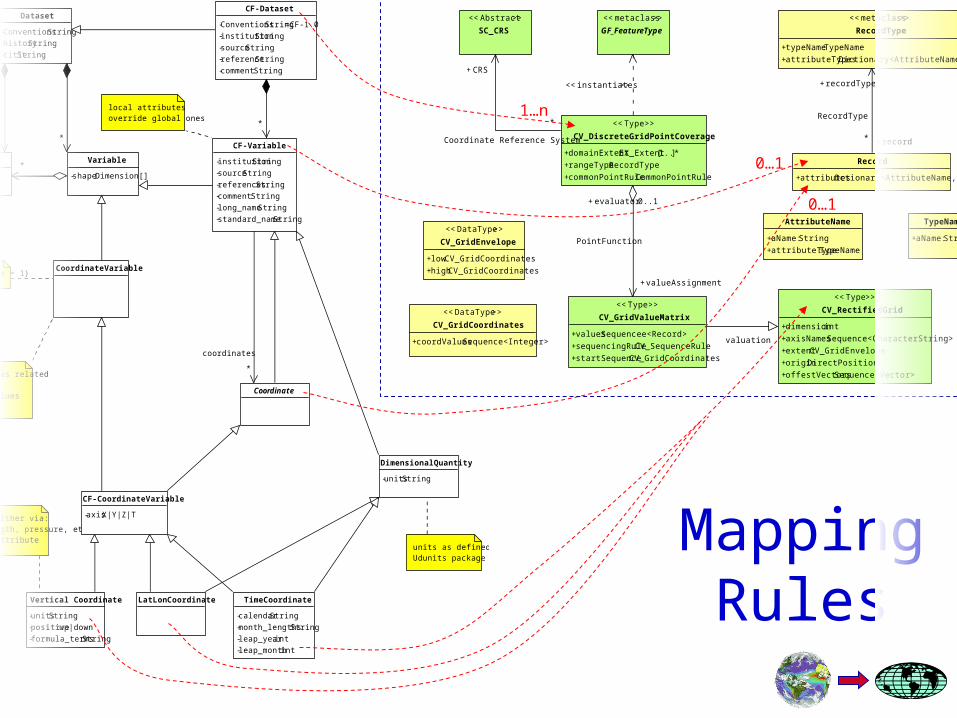
Concepts mapping in brief
ES concepts Mapping cardinality
Geo-Information concepts
Dataset 1…n Coverage
Dimension n…m Grid/Multipoint Domain, CS, CRS
Variable n…m Scalar/parametric Rangeset, Grid/Multipoint Domain, CS, CRS
Attribute n…m Any
Semantics level
Adding extra semantics

The Implementation• ES data model
– netCDF– Extra metadata: CF conventions
• GIS Coverage model– ISO 19123: DiscreteGridPointCoverage
• Harmonization implementation-style– Declarative style
• Mediation Markup Language• Rule-based procedure

CF-netCDF Model
• NetCDF data model was extended adding a set of conventions– One of the most
popular convention is the Climate and Forecasting metadata convention (CF)
– Introduce more specific semantic elements (i.e. metadata) required by different communities to fully describe their datasets
Coordinate
{ shape->size = 1}
units as defined inUdunits package
TimeCoordinate
-calendar:String
-month_lengths :String
-leap_year:int
-leap_month :int
Identified either via:- units (length, pressure, etc.)- positive attribute
Vertical Coordinate
-units:String
-positive:up|down
-formula_terms:String
LatLonCoordinate
CF-CoordinateVariable
-axis:X|Y|Z|T
DimensionalQuantity
-units:String
- same name as related dimension - numeric values- monotonic
Dimension
CoordinateVariable
local attributes override global ones
CF-Variable
-institution :String
-source:String
-references:String
-comment:String
-long_name :String
-standard_name:String
Variable
-shape:Dimension[]
Dataset
-Conventions:String
-history:String
-title:String
CF-Dataset
-Conventions:String=CF-1.0
-institution :String
-source:String
-reference:String
-comment:String
CF-netCDFProfileModel
*
*
*
*
*
coordinates
netCDF Model

<< metaclass >>
GF_FeatureType
<< Type >>
CV_ContinuousQuadrilaterGridCoverage
<< Type >>
CV_SegmentedCurveCoverage
<< Type >>
CV_HexagonalGridCoverage
<< Type >>
CV_TINCoverage
<< Type >>
CV_ThiessenPolygonCoverage
<< Type >>
CV_Coverage
<< Type >>
CV_ContinuousCoverage
<< Type >>
CV_DiscreteSolidCoverage
<< Type >>
CV_DiscreteSurfaceCoverage
<< Type >>
CV_DiscretePointCoverage
<< Type >>
CV_DiscreteCurveCoverage
<< Type >>
CV_DiscreteCoverage
<< Type >>
CV_DiscreteGridPointCoverage
CoverageSubclassesModel
(discriminator)
<< instantiates >>ISO 19123 Coverage subtypes

DiscreteGridPointCoverage
<< DataType >>
CV_GridCoordinates
+coordValues:Sequence<Integer>
<< DataType >>
CV_GridEnvelope
+low:CV_GridCoordinates
+high:CV_GridCoordinates
<< Type >>
CV_RectifiedGrid
+dimension:int
+axisNames:Sequence<CharacterString>
+extent:CV_GridEnvelope
+origin:DirectPosition
+offestVectors:Sequence<Vector>
<< Type >>
CV_GridValueMatrix
+values:Sequencee<Record>
+sequencingRule:CV_SequenceRule
+startSequence:CV_GridCoordinates
<< Abstract >>
SC_CRS
<< metaclass >>
GF_FeatureType
<< Type >>
CV_DiscreteGridPointCoverage
+domainExtent:EX_Extent[1..*]
+rangeType:RecordType
+commonPointRule :CommonPointRule
DiscreteGridPointCoverageProfile model
<< instantiates >>
*
CRS+
Coordinate Reference System
evaluator+ 0..1
valueAssignment+
PointFunction
valuation
Record
+attributes:Dctionary<AttributeName, Any>
<< metaclass >>
RecordType
+typeName:TypeName
+attributeTypes :Dictionary<AttributeName, TypeName>
TypeName
+aName:String
AttributeName
+aName:String
+attributeType:TypeName
record+*
recordType+
RecordType

Mapping Rules
<< DataType >>
CV_GridCoordinates
+coordValues:Sequence<Integer>
<< DataType >>
CV_GridEnvelope
+low:CV_GridCoordinates
+high:CV_GridCoordinates
<< Type >>
CV_RectifiedGrid
+dimension:int
+axisNames:Sequence<CharacterString>
+extent:CV_GridEnvelope
+origin:DirectPosition
+offestVectors:Sequence<Vector>
<< Type >>
CV_GridValueMatrix
+values:Sequencee<Record>
+sequencingRule:CV_SequenceRule
+startSequence:CV_GridCoordinates
<< Abstract >>
SC_CRS
<< metaclass >>
GF_FeatureType
<< Type >>
CV_DiscreteGridPointCoverage
+domainExtent:EX_Extent[1..*]
+rangeType:RecordType
+commonPointRule :CommonPointRule
DiscreteGridPointCoverageProfile model
<< instantiates >>
*
CRS+
Coordinate Reference System
evaluator+ 0..1
valueAssignment+
PointFunction
valuation
Record
+attributes:Dctionary<AttributeName, Any>
<< metaclass >>
RecordType
+typeName:TypeName
+attributeTypes :Dictionary<AttributeName, TypeName>
TypeName
+aName:String
AttributeName
+aName:String
+attributeType:TypeName
record+*
recordType+
RecordType
Coordinate
{ shape->size = 1}
units as defined inUdunits package
TimeCoordinate
-calendar:String
-month_lengths :String
-leap_year: int
-leap_month :int
Identified either via:- units (length, pressure, etc.)- positive attribute
Vertical Coordinate
-units:String
-positive:up|down
-formula_terms:String
LatLonCoordinate
CF-CoordinateVariable
-axis:X|Y|Z|T
DimensionalQuantity
-units:String
- same name as related dimension - numeric values- monotonic
Dimension
CoordinateVariable
local attributes override global ones
CF-Variable
-institution :String
-source:String
-references:String
-comment:String
-long_name :String
-standard_name:String
Variable
-shape:Dimension[]
Dataset
-Conventions:String
-history:String
-title:String
CF-Dataset
-Conventions:String=CF-1.0
-institution :String
-source:String
-reference:String
-comment:String
CF complete Class Diagram
*
*
*
*
*
coordinates
Coordinate
{ shape->size = 1}
units as defined inUdunits package
TimeCoordinate
-calendar:String
-month_lengths :String
-leap_year:int
-leap_month :int
Identified either via:- units (length, pressure, etc.)- positive attribute
Vertical Coordinate
-units:String
-positive:up|down
-formula_terms:String
LatLonCoordinate
CF-CoordinateVariable
-axis:X|Y|Z|T
DimensionalQuantity
-units:String
- same name as related dimension - numeric values- monotonic
Dimension
CoordinateVariable
local attributes override global ones
CF-Variable
-institution :String
-source:String
-references:String
-comment:String
-long_name :String
-standard_name:String
Variable
-shape:Dimension[]
Dataset
-Conventions:String
-history:String
-title:String
CF-Dataset
-Conventions:String=CF-1.0
-institution :String
-source:String
-reference:String
-comment:String
CF complete Class Diagram
*
*
*
*
*
coordinates
<< DataType >>
CV_GridCoordinates
+coordValues:Sequence<Integer>
<< DataType >>
CV_GridEnvelope
+low:CV_GridCoordinates
+high:CV_GridCoordinates
<< Type >>
CV_RectifiedGrid
+dimension:int
+axisNames:Sequence<CharacterString>
+extent:CV_GridEnvelope
+origin:DirectPosition
+offestVectors:Sequence<Vector>
<< Type >>
CV_GridValueMatrix
+values:Sequencee<Record>
+sequencingRule:CV_SequenceRule
+startSequence:CV_GridCoordinates
<< Abstract >>
SC_CRS
<< metaclass >>
GF_FeatureType
<< Type >>
CV_DiscreteGridPointCoverage
+domainExtent:EX_Extent[1..*]
+rangeType:RecordType
+commonPointRule :CommonPointRule
DiscreteGridPointCoverageProfile model
<< instantiates >>
*
CRS+
Coordinate Reference System
evaluator+ 0..1
valueAssignment+
PointFunction
valuation
Record
+attributes:Dctionary<AttributeName, Any>
<< metaclass >>
RecordType
+typeName:TypeName
+attributeTypes :Dictionary<AttributeName, TypeName>
TypeName
+aName:String
AttributeName
+aName:String
+attributeType:TypeName
record+*
recordType+
RecordType
0…1
0…1
1…n
Mapping Rules

Concept type Definition Notes
An observation is a function from a given multidimensional real domain (d) to a multidimensional real co-domain (c).Note: a netCDF variable is a special case of Observation (with domain in d and c=1).
d = {b1, b2, …, bn}A dataset is a set of observation data.Note: a netCDF file is a special case of Dataset.
S: {3, SCS} A Spatial Domain is 3 with a law from 3 to a location in the physical universe (Spatial Coordinate System). A 2D Spatial (Planar) Domain is the restriction of S to 2.
Domain and Functional Definitions
Observation Data/Observation b: d c
d, c
B= {b}
Dataset
Spatial Domain

Concept type Definition Notes
T: {, TCS} A Temporal Domain is with a law from to a location in the physical time (Temporal Coordinate System)
c: {S, T} n
n
C = {c}
A coverage is a function defined from a Spatio-Temporal Domain (e.g. Lat, Lon, Height, Time) to a multidimensional real co-domain (n).Note: if a set of CF-netCDF coordinate variables is a Spatio-Temporal Domain, then CF-netCDF variables defined over the corresponding dimensions can be mapped to Coverages
Domain and Functional Definitions
Temporal Domain
Coverage
Concept type Definition Notes
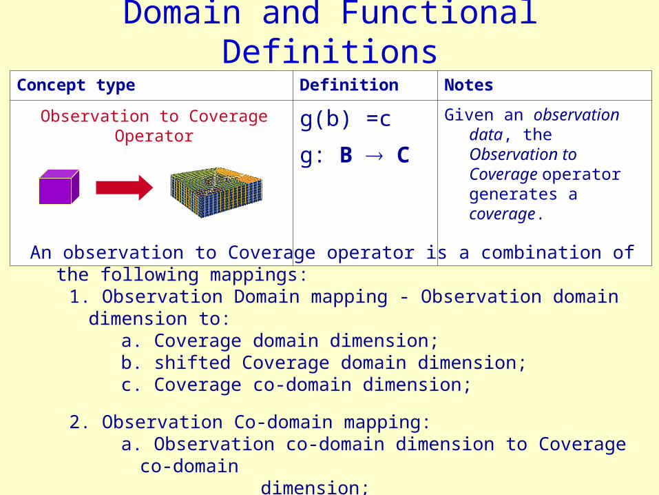
g(b) =c
g: B C
Given an observation data, the Observation to Coverage operator generates a coverage.
Domain and Functional Definitions
Observation to Coverage Operator
An observation to Coverage operator is a combination of the following mappings:1. Observation Domain mapping - Observation domain dimension to:
a. Coverage domain dimension;b. shifted Coverage domain dimension;c. Coverage co-domain dimension;
2. Observation Co-domain mapping: a. Observation co-domain dimension to Coverage co-domain
dimension;
3 . Metadata elements mapping.

Concept type Definition Notes
s = {g1, g2, …,
gn}
A Dataset to Coverages operator consists of a set of Observation to Coverage operators.
Hence, Given an dataset element, the Dataset to Coverages operator generates a set of coverage elements.
(Another task is the metadata elements mapping from dataset to the whole set of coverages).
Domain and Functional Mappings
Dataset to Coverage Operator
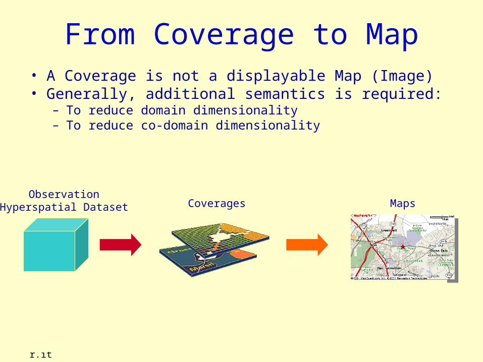
From Coverage to Map• A Coverage is not a displayable Map (Image)• Generally, additional semantics is required:
– To reduce domain dimensionality– To reduce co-domain dimensionality
ObservationHyperspatial Dataset Coverages Maps

Domain and Functional MappingsConcept type Definition Notes
m: 2D-S M= {m}
A Map is a function defined from a 2D Spatial (Planar) Domain (i.e. Lat, Lon) to a real co-domain.
p(c) = m
p: C M
A Coverage Portrayal
operator transforms a coverage to a map, by means of a combination of the following operations:
– Domain restriction (to a
certain Z0 and T0);– Co-domain restriction (to
a scalar quantity).
Map
Coverage Portrayal Operator

Data model harmonization: Implementation style
Abstract model level
HyperspatialObservation
Coverage/Feature
netCDF + CFContent model level
ISO 19123 Coverage Model
GIS InformationCommunity
Earth SciencesInformationCommunity
Encoding level ncML GMLGGMLMLGGMLML
Mapping rules
Mapping rules

Data model harmonization
ISO 19123Data Model
netCDFData Model
CFMetadata
Data Models Mediation
GISInformationCommunity
Earth SciencesInformationCommunity
Information Society(e.g. Spatial Data Infrastructure)
ncML-GML
Encoding Model
ncML-GML
Encoding ModelncML
EncodingModel
ncMLEncoding
Model
GML 3.xEncoding
Model
GML 3.xEncoding
Model
WCS 1.xContent Model
WCS 1.xContent Model
WFSContent Model

ncML-GML• Mediation Markup Language• An extension of ncML (netCDF Markup Language) based on GML
(Geography Markup Language) grammar

Available Language specification and Tools
• The ncML-GML markup language implements the presented reconciliation model
• It is a Mediation Markup Language between ncML (netCDF Markup Language) and GML– An extension of ncML core schema, based on GML grammar
• NcML-GML version 0.7.3– based on GML 3.1.1
• N2G version 0.8– Java API for ncML-GML ver. 0.7.3
• WCS-G– WCS 1.0 which supports ncML-GML/netCDF documents
• Subsetting (domain and range-set)– netCDF– ncML-GML 0.7.3
• WCS light client– Test client for WCS-G
• GI-go thick client
GGMLMLGGMLML
JavaJavaWeb StartWeb Start
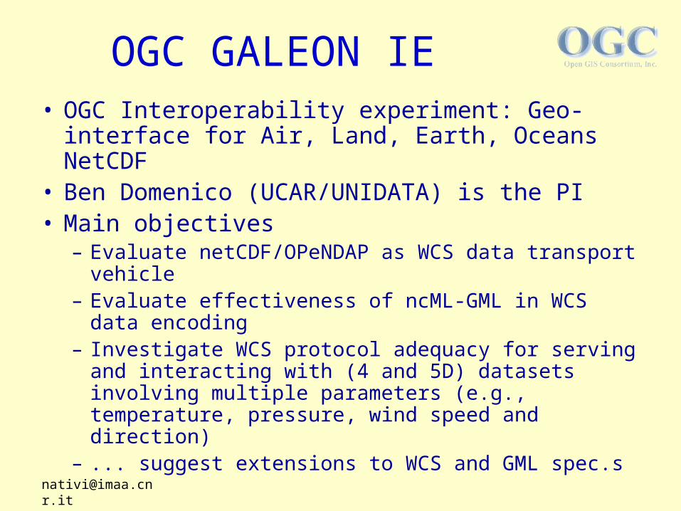
• OGC Interoperability experiment: Geo-interface for Air, Land, Earth, Oceans NetCDF
• Ben Domenico (UCAR/UNIDATA) is the PI• Main objectives
– Evaluate netCDF/OPeNDAP as WCS data transport vehicle
– Evaluate effectiveness of ncML-GML in WCS data encoding
– Investigate WCS protocol adequacy for serving and interacting with (4 and 5D) datasets involving multiple parameters (e.g., temperature, pressure, wind speed and direction)
– ... suggest extensions to WCS and GML spec.s
OGC GALEON IE

• Partecipants– Unidata/UCAR– NASA Geospatial
Interoperability Office– IMAA CNR /
University of Florence– George Mason University– CadCorp– JPL– Interactive Instruments– University of Applied Sciences– International University Bremen– NERC NCAS/British Atmospheric Data Center– University of Alabama Huntsville– Research Systems, Inc. (IDL)– Texas A&M University
GALEON
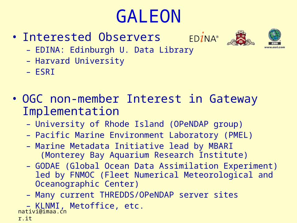
• Interested Observers– EDINA: Edinburgh U. Data Library– Harvard University– ESRI
• OGC non-member Interest in Gateway Implementation– University of Rhode Island (OPeNDAP group)– Pacific Marine Environment Laboratory (PMEL)– Marine Metadata Initiative lead by MBARI
(Monterey Bay Aquarium Research Institute)– GODAE (Global Ocean Data Assimilation Experiment) led by
FNMOC (Fleet Numerical Meteorological and Oceanographic Center)
– Many current THREDDS/OPeNDAP server sites– KLNMI, Metoffice, etc.
GALEON

OGC GALEON IE • GALEON: Geo-interface for Air, Land, Earth, Oceans NetCDF• Use Case #3 objective: To access a netCDF multi-D dataset through
WCS-THREDDS gateway getting a ncML-GML or a netCDF file
– Return a WCS getCapabilities response based on THREDDS inventory list catalogs – Return a WCS describeCoverage response based on ncML-GML data model– Serve the dataset as: 1) a ncML-GML doc 2) a netCDF file 3) an OPenDAP URI– Experiment a WCS client able to access and analyze 5D datasets in ncML-GML form
WCS Client Gateway &
WCS Server
W C Ste s t c l ie nt
fo r nc M L -G
W C S4
nc M L -G M L
d es c rib eC o veragegetC o verage
ne tC D F2
nc M L -G
HTTP service
SOAP service
T HR E D D S/
O P eN D AP
THREDDS Data Server
Collections of numerical forecast model output
XML
GGMLMLGGMLML

Datasets successfully Mapped • Datasets to be managed in the IE GALEON
• Benefits– Leverage existing datasets and servers– Decouple data from description– Support client-side computation– Support reconstructing the original netCDF
Test DatasetCoverage domain
Coverage co-domain
CRS Data sizeCoverages Creation
simple 2D + t scalar (single) Geo small YES
sst 2D + t scalar (single) Geo medium YES
sst-2v 2D + t scalar (array) Geo medium YES
trid 3D scalar (single) Geo small YES
striped_can 2D + t + P parametric Geo large YES
ruc3D + t + P parametric Geo + Proj large NO
GGMLMLGGMLML

GSN interoperability framework • OGC Demos in GEOSS Workshops• Components to be experimented
– Clients: – Catalogs:– Geo-processing Services:– Data Access (WMS, WFS, WCS):
2006 International Geoscience And Remote Sensing Symposium
Denver. Colorado USA, July 31 – August 4, 2006

Spatial Data Infrastructure (Geospatial Data Infrastructure)
• SDI mission– mechanism to facilitate the sharing and exchange of geospatial
data. – SDI is a scheme necessary for the effective collection,
management, access, delivery and utilization of geospatial data;– it is important for: objective decision making and sound land
based policy, support economic development and encourage socially and environmentally sustainable development
• Main functionalities– Resource Discovery– Resource Evaluation– Data Portrayal (Preview)– Data Mapping (Overlaying & Visualization)– Data Transfer

SDI Architecture
ESS Realm Land Management Realm
Geospatial ResourcesGeospatial Resources
Technological StandardsTechnological Standards
Access InfrastructuresAccess Infrastructures
Se
curi
ty
Infr
ast
ruct
ure
Da
ta P
olic
y
SOCIETY
Two kinds of Geospatial resources
•ES•Land Managements(mainly GIS-based)

SDI technological Framework
GeoTIFF
DWG
SHP
Others...
..
LandManag.mnt
THREDDS
Data
Server
netCDF
HDF
GRIB
Others...
..
ADDE
IDD/LDM
OPeNDAP
HTTP
ES
WFS
WCS
SDI Discovery &Cataloguing tier
WMS
SDI Presentation tier
SDI Data Access tier
SDI Dataset tier
Data
Models
M
edia
tion
Pro
toco
l s
Adapta
tion
Data
Mod
els
M
ed
iati
on
Pro
tocol s
Ad
ap
tati
on
Data
Mod
els
M
ed
iati
on
Pro
tocol s
Ad
ap
tati
on
Catalog service
based on
ISO 19115
profile
(INSPIRE-
compliant)
GGML
ML
GGML
ML
GG
22
GM
L

Main Technologies• GIS technologies
– OGC WFS, WCS, WMS, GML, ISO 19115 profile (INSPIRE)
• ES technologies– CF-netCDF, ncML, TDS/OPenDAP, etc.
• Interoperability technologies– ncML-GML, GI-cat, WCS-G, WC2MS
GGMLMLGGMLML GG 22

NcML-GML: model harmonization
ISO 19123Coverage
Model
netCDFData Model
CFMetadata
GML 3.xEncoding
Model
GML 3.xEncoding
Model
Data Models Mediation
GISInformationCommunity
Earth SciencesInformationCommunity
ncMLEncoding
Model
ncMLEncoding
Model
WCS 1.xContent Model
WCS 1.xContent Model
WFSContent Model
ncML-GML
Encoding Model
ncML-GML
Encoding Model
GIS - CoveragesES Observation Dataset
GGMLMLGGMLML

CS-W
GI-Cat• Caching, asynchronous, brokering server with security
support, which can federate six IGCD kinds of sources• Catalog of Catalogs/Catalog Broker solution• Service-oriented technology
WCS
T HREDDS
GI-Cat
R eg istry
ESA EOLI
M ersea CDI
Mediation
Mediation
Mediation
Mediation
Distr ibution
RepositoryMe ssa g in g Se cu rity
WM SMediation
R eg istry
Mediation
Mediation
Mediation
Mediation
Distr ibution
RepositorySecu r ityMe ssag ing
Message-oriented asynchronous interactionNASA ESG

WC2MS• A solution to introduce semantics:
– To reduce domain dimensionality– To reduce co-domain dimensionality
• The above semantics is captured and encoded in CPS request parameters
Extra Semantics
CoverageMap
22
WMS

Engineering and Information View
WC2MS
GI-catWCSWMSTHREDDSEOLICDI
WCS
WMS (ECWP)
WFS/WMS
WMS
Heterg.ousprotocol
GI-catprotocol
Heterg.ousprotocol
GI-regprotocol
Thin-Client
AJAXThin-ClientHTML
ESNodes
Imagery Gridded &
Coverage data
Feature-based dataLand
ManagementNodes
GI-catWCSWMS
THREDDSEOLICDI
ncML-GML/
netCDF
geoTIFF/JPG /(ECW)
XML dialects GML/SVG/JPG
XML dialects
XML (ISO 19139)
geoTIFF/JPG/SVG
XML dialect
SHPnetCDF-CF
WCS-G WFSWMS

Lucan SDI• Basilicata Region
– River Basin Authority– Regional Environmental Agency– Land Management & Cadastre Regional
Authorities– Prefecture– Regional Civil Protection Centers– Italian Space Agency– National Research Council Institutes– Academia– SMEs
• Pilot Application– Hydrogeological disturbance survey
• Ground deformations• Landslides

m a.s.l.
0
1000
2000
500
m a.s.l.
0
1000
2000
500
0
1000
2000
500
Thyrrenian sea
Ionian sea
Potenza. Matera.Potenza. Matera.
Lucanian Apennine
Density of landslide areas = 27 for every 100 Km2
200.000 hectares of the italian surface affected by landslides and erosional phenomena
Towns and countries affected by serious hazards (116/131) 89%
F. Guzzetti (2000). “Landslide fatalities and the evaluation of landslide risk in Italy”, Engineering Geology, 58, 89-107
Hydrogeological hazard in the Basilicata region
Satriano di Lucania

DInSAR mean deformation velocity map
Satriano di Lucania
Perrone, A., Zeni, G., Piscitelli, S., Pepe, A., Loperte, A., Lapenna, V., Lanari, R. (2006) – Joint analysis of SAR Interferometry and Electrical Resistivity Tomography surveys for investigating ground deformation: the case study of Satriano di Lucania (Potenza, Italy) – Engineering Geology, in press.

Risk map of the Satriano di Lucania territory
From the Autorità di Bacino della Basilicata
R1 – Moderate risk
R2 – Mean risk
R3 – High risk
R4 – Very high risk
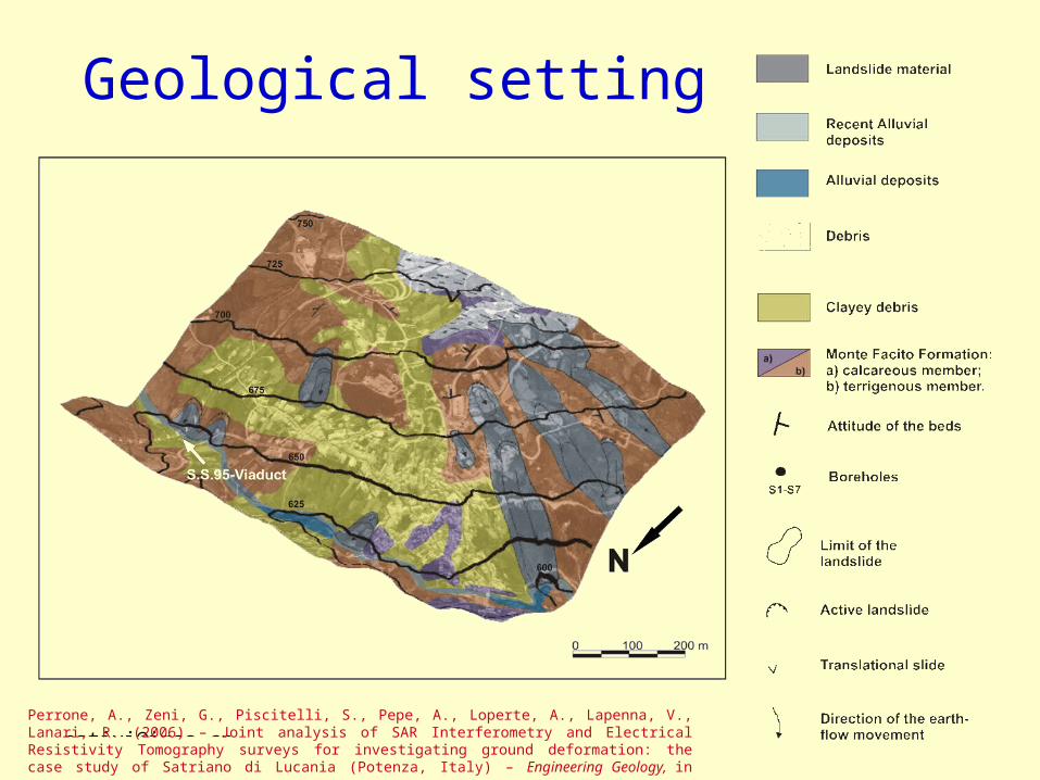
Geological setting
Perrone, A., Zeni, G., Piscitelli, S., Pepe, A., Loperte, A., Lapenna, V., Lanari, R. (2006) – Joint analysis of SAR Interferometry and Electrical Resistivity Tomography surveys for investigating ground deformation: the case study of Satriano di Lucania (Potenza, Italy) – Engineering Geology, in press.

DInSAR mean deformation velocity map of Satriano di Lucania
Perrone, A., Zeni, G., Piscitelli, S., Pepe, A., Loperte, A., Lapenna, V., Lanari, R. (2006) – Joint analysis of SAR Interferometry and Electrical Resistivity Tomography surveys for investigating ground deformation: the case study of Satriano di Lucania (Potenza, Italy) – Engineering Geology, in press.

DInSAR mean deformation velocity map and electrical resistivity tomographies
Perrone, A., Zeni, G., Piscitelli, S., Pepe, A., Loperte, A., Lapenna, V., Lanari, R. (2006) – Joint analysis of SAR Interferometry and Electrical Resistivity Tomography surveys for investigating ground deformation: the case study of Satriano di Lucania (Potenza, Italy) – Engineering Geology, in press.

CYCLOPS project• CYber-Infrastructure for CiviL protection Operative
ProcedureS • Special Support Action funded by the EC• Support the GMES Community to develop specific
services based on Grid technology• Multidisciplinary project
– Civil Protections/GMES Community• Italian CP, French CP, Portuguese CP, Prefecture of Chania
(Greece)
– Grid Community• INFN/CERN (EGEE people)
– Geospatial Community• CNR-IMAA, TEI (Greece)
• website: http://www.cyclops-project.eu
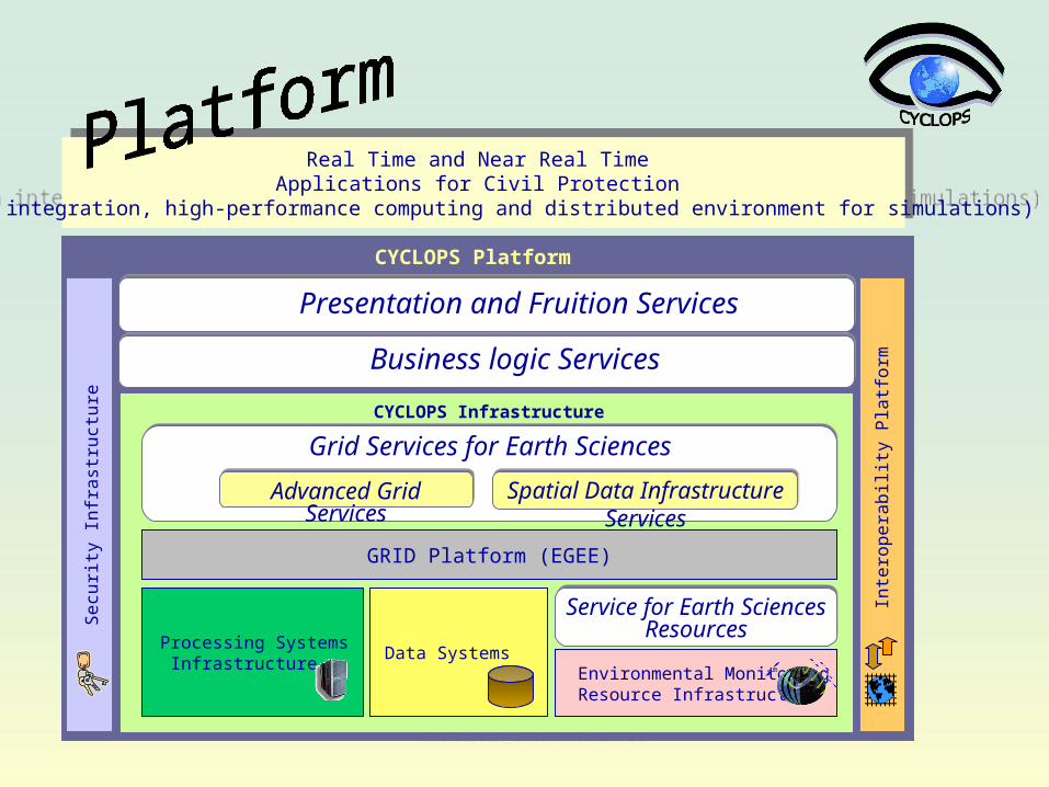
CYCLOPS Platform
CYCLOPS Infrastructure
Processing Systems Infrastructure
Data Systems
GRID Platform (EGEE)
Se
curit
y In
fra
stru
ctu
re
Real Time and Near Real Time Applications for Civil Protection
(Data integration, high-performance computing and distributed environment for simulations)
Real Time and Near Real Time Applications for Civil Protection
(Data integration, high-performance computing and distributed environment for simulations)
Inte
rop
era
bili
ty P
latf
orm
Environmental MonitoringResource Infrastructure
Service for Earth Sciences Resources
Grid Services for Earth Sciences
Spatial Data Infrastructure Services
Advanced Grid Services
Business logic Services
Presentation and Fruition Services

Main Conclusions• ES and GIS data model interoperability is more and more important for
Society’s applications
• Traditional GIS metadata doesn’t seem to be sufficient or appropriate for all types of ES datasets (e.g. complex forecast model output).
• The GIS coverage concept seems to be a good solution to bridge GIS and ES data models
• Complex ES datasets (hyperspatial data) could be projected generating a set of “simple” coverages
• A solution for mapping complex hyperspatial netCDF-CF1 datasets on a set of GIS coverages has been developed: the ncML-GML
• It was experimented in the framework of the OGC GALEON IE through OGC WCS
• Future experimentations will consider:– A regional SDI – A grid-based platform for GMES and Civil Protection applications– Interoperability networks, such as the OGC GSN.