Embed Size (px)
Citation preview
Finding of No Practicable Alternative (EO 11988)
NOAA Office of Marine and Aviation Operations Aircraft Operations Center Relocation page1/11
National Oceanic and Atmospheric Administration
Finding of No Practicable Alternative (EO 11988)
Proposed NOAA Aircraft Operations Center Relocation
November 28, 2016
1. Introduction and Background Information
This document reviews activities and decisions taken per Executive Order (EO) 11988, Floodplain Management (1977) for the NOAA Office of Marine and Aviation Operations (OMAO) Aircraft Operations Center (AOC) Relocation project (proposed action). The proposed action consists of facility construction or renovation required to support relocation of the NOAA Aircraft Operations Center. The NOAA AOC, operated by the OMAO, is required to relocate from its existing facility at MacDill Airforce Base (MacDill) in Tampa, Florida. Two locations were identified by NOAA AOC as options. The proposed action has also been evaluated in an Environmental Assessment (EA) prepared by NOAA under the National Environmental Protection Act (NEPA). Facilities have been considered at Lakeland-Linder Regional Airport (Action Alternative 1, Alternative 1 or LAL), located within the southwest boundary of the city of Lakeland, Polk County, Florida. Facilities have also been considered at St. Petersburg-Clearwater International Airport (Action Alternative 2, Alternative 2 or PIE), a public/military airport within an unincorporated area of Pinellas County serving the St. Petersburg-Clearwater-Tampa Bay Metro Area, and adjacent to Tampa Bay. Proposed actions at each of these alternatives are further described below. To avoid or minimize adverse impacts of a proposed action on floodplains, NOAA follows its Guidance on Compliance with the Implementing Procedures for Executive Orders 11988 and 11990 (2012) and the Water Resources Council (WRC) “Guidelines for Implementing Executive Order 11988, Floodplain Management, and Executive Order 13690” (2015). EO 11988 requires federal agencies to avoid, to the extent possible, the long- and short-term adverse impacts associated with the occupancy and modification of floodplains and to avoid direct and indirect support of floodplain development wherever there is a practicable alternative. This objective applies to acquiring, managing, and disposing of federal lands and facilities, such as that proposed for the OMAO AOC Relocation project. The intent of EO 11988 is met by implementing an eight-step process, where applicable. Although a separate federal process from the NEPA process, NOAA may accommodate the requirements of E.O. 11988 to the extent possible through applicable NEPA procedures found in NOAA Administrative Order (NAO) 216-6A, “Compliance with the National Environmental Policy Act, Executive Orders 12114, Environmental Effects Abroad of Major Federal Actions; 11988 and 13690, Floodplain Management; and 11990, Protection of Wetlands.”

Finding of No Practicable Alternative (EO 11988)
NOAA Office of Marine and Aviation Operations Aircraft Operations Center Relocation page2/11
In February 1978, the WRC issued Floodplain Management Guidelines for implementing Executive Order 11988. These guidelines provide a section-by-section analysis of the Executive Order, definition of key terms, and an eight-step decision-making process for carrying out the Executive Order’s directives. The process contained in the WRC guidelines incorporates the basic requirements of Executive Order 11988. Briefly, this eight-step process is:
1. Floodplain and/or wetland determination;
2. Public notification;
3. Identify and evaluate practicable alternatives to locating in the base floodplain;
4. Identify the impacts of the proposed action;
5. Evaluate measures to reduce potential adverse impacts of the proposed action;
6. Re-evaluate the alternatives;
7. Make the final determination and present the decision; and
8. Implement the action. NOAA determined to implement these eight steps for practicable alternatives to its proposed action to relocate the OMAO’s AOC that may occur within the 1%-chance (or 100-year) floodplain.
2. EO 11988 Eight Step Process
The following eight steps in EO 11988 have been taken by NOAA for the proposed AOC Relocation project in conjunction with the NEPA process when possible. 2.1 Floodplain determination Under the provisions of EO 11988 Section 2(a)(1), before taking an action, each agency shall determine whether the proposed action will occur in a floodplain--for major Federal actions significantly affecting the quality of the human environment, the evaluation required below will be included in any statement prepared under Section 102(2)(C) of NEPA. The NOAA Guidance on implementing EO 11988 states that in order to determine whether a proposed action will occur in a 100-year (or 500-year for a critical action1) floodplain, the first reference should be the FEMA Flood Insurance Rate Map (FIRM). If the maps prepared by FEMA do not adequately characterize the flood hazard potential for the proposed action, other sources that merit investigation may be used, such as flood hazard studies, hydrologic studies, soil surveys, and other investigations.
1Critical actions include facilities such as hospitals, police stations, fire stations, emergency communication centers, or and facilities containing extremely hazardous materials that would threaten the public if released. The NOAA AOC does not qualify as an emergency response facility or possess extremely hazardous materials that would be a threat to the public if released.
Finding of No Practicable Alternative (EO 11988)
NOAA Office of Marine and Aviation Operations Aircraft Operations Center Relocation page3/11
2.1.1 Lakeland-Linder Regional Airport Proposed facilities under consideration at LAL (Alternative 1) are located within the southwest boundary of the city of Lakeland, Polk County, Florida. The actions evaluated in this section are based on the information received by NOAA in the City of Lakeland’s response to NOAA Request for Lease Proposals Tampa/St. Pete- Clearwater, FL. RLP No. 16EKA0100C, dated August 12, 2016 (resubmittal). The proposed action at Alternative 1 would involve replacement of an existing hangar structure located in the southern portion of LAL. The portion of the hangar potentially affected is at 3450 Flightline Drive and is currently occupied by Rob Dinic Interiors, a firm that customizes and refurbishes aircraft and helicopter interiors. Replacement of the southern two-thirds of the 36-year-old hangar unit at this address would occur by demolishing that portion of the concrete block structure, replacing its cement foundation with a thicker 10-inch deep cement foundation and attaching a pre-engineered metal hangar structure (City of Lakeland, 2016). The northern one-third of the unit would retain its existing shell and be reconfigured internally to meet NOAA’s office, shop and storage needs. A vehicle parking area that would accommodate the required 110 spaces is adjacent to the hangar, plus adequate apron area and aircraft tie-down locations as specified in the OMAO request for bids is proposed. Vehicle access is via roadways adjacent to the south side of the airport boundary, primarily Old Medulla Road and West Pipkin Road leading to Airside Center Drive and Flightline Drive. Crane, jack hammer, front loader, bobcat loader, and haul trucks would be mobilized to remove portions of the existing hangar and its slab foundation and remove remnant or unnecessary underground utility infrastructure. Site work would include the framing and installation of a slab foundation to 10-inches thickness, extension of underground mechanical, electrical and plumbing conduit, erection of a modular metal building shell, installation of glazing and siding, and completion of site work for ramps, tie-downs, striping and parking. Hangar door installation and utility/fire protection measures would be installed and connected, followed by completion of interior framing, drywall, flooring and painting. Substantial completion is estimated by April 21, 2017. Upon substantial completion of all or portions of the construction activities, NOAA would move equipment, aircraft, and personnel into ready spaces. Operations would include administrative, workshop, storage, and engineering-related tasks in support of crew and aircraft readiness for various environmental monitoring and sensing missions. Periodic delivery of supplies, parts, and large airframe and power plant components would occur during operations and to support maintenance and retrofitting of aircraft. AOC and other mission-related aircraft would access the proposed facility via use of runways and taxiways at LAL. LAL has been previously documented to contain approximately 5.05 acres of 100-year floodplains as delineated by FEMA on the current Flood Insurance Rate Map (FIRM) Panel No. 12105C0460F and dated December 20, 2000 (see Figure 1) (FEMA, 2000). FEMA classifies this 100-year floodplain as Zone A. Zone A 100-year floodplains do not have a base flood elevation associated with them. However, the December 2000 FIRM will not be in effect when the proposed action would be permitted for construction, and the December 2000 FIRM is not considered to be the “best available data” for the floodplain.
Finding of No Practicable Alternative (EO 11988)
NOAA Office of Marine and Aviation Operations Aircraft Operations Center Relocation page4/11
FEMA and Cooperating Technical Partners initiated physical map revisions to the FIRMS for all of Polk County in 2014, which were completed in August 2014. The analysis was performed to change zone designations, Base Flood Elevations, and Special Flood Hazard Areas, and to incorporate previously issued Letters of Map Revision, and to reflect updated topographic information. This analysis is the “best available data” for floodplains in Polk County, including at the prospective project location, and is provided in the pending FEMA FIRM Panel No. 12105C0460G, which will become the official FIRM on December 22, 2016 (FEMA, 2016). The pending FIRM indicates a portion of the taxiway typically used for aircraft movements and could be used by AOC aircraft and would be within Zone A (see Figure 2). Therefore, this alternative would occur in the floodplain. 2.1.2 St. Petersburg-Clearwater International Airport Proposed facilities under consideration at PIE (Alternative 2) are located within an unincorporated area of Pinellas County, nine miles north of downtown St. Petersburg, Florida, and seven miles southeast of Clearwater, Florida. The actions evaluated in this section are based on the information received by NOAA in Sheltair Aviation’s response to NOAA Request for Lease Proposals Tampa/St. Pete-Clearwater, FL. RLP No.16EKA0100C and dated August 12, 2016 (resubmittal), including architectural drawings prepared by Paul Jackson Architects, Inc. The facilities offered at Alternative 2 would require replacement of the shell of the former Clearwater Aviation, Inc., hangar located in the eastern portion of PIE. The 452- by 215-foot hangar is owned and operated by Sheltair Aviation. This 97,280 square-foot hangar structure is estimated to have an average existing finished floor elevation of approximately 8 feet, NAVD 88. Replacement of the exterior shell of the circa-1964 hangar would occur by removing the metal siding and roofing while keeping the foundation and the metal frame, consisting of vertical metal supporting braces and cross beams (Paul Jackson Architects, 2016). The structural renovations and replacements would include attaching a new 24-foot-tall storage high bay with an added footprint of roughly 45-foot by 175-foot area and applying new, replacement metal siding and roofing to the entire hangar frame. A vehicle parking area that would accommodate the NOAA-required 110 spaces is across a tarmac and 200 feet south of the subject hangar; adequate apron area and aircraft tie-down locations are present as specified in the OMAO request for bids is proposed. Vehicle access is via roadways adjacent to the west side of the airport boundary, primarily 49th Street North and Roosevelt Boulevard leading to Fairchild Drive and Spadco Drive. Local regulations (SWFWMD General Stormwater Quantity and Flood Control requirements) require that structures for industrial, commercial or other non-residential buildings susceptible to flood damage should have the lowest floor elevated above the 100-year flood elevation, or be designed and constructed so that below the 100-year flood elevation the structure and attendant utility facilities are watertight and capable of resisting the effects of the regulatory flood. The design should take into account flood velocities, duration, rate of rise, hydrostatic and hydrodynamic forces, the effect of buoyancy and impacts from debris. Flood proofing measures should be operable without human intervention and without an outside source of electricity. The proposed facilities at PIE would be designed in accordance with these requirements by flood-proofing of the existing main 97,280 square-foot structure and adjacent connecting structural additions. Crane, jack hammer, front loader, bobcat loader and haul trucks would be mobilized to remove the hangar siding and roofing, as well as office interior and remnant and unnecessary utility infrastructure. Site work
Finding of No Practicable Alternative (EO 11988)
NOAA Office of Marine and Aviation Operations Aircraft Operations Center Relocation page5/11
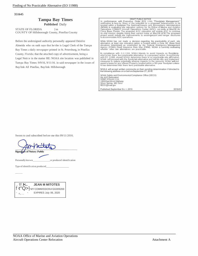
would include extension of underground mechanical, electrical and plumbing conduit, placement of metal building shell siding and roofing, installation of man-doors, glazing and siding, construction of the attached high bay segment and completion of site work for ramps, tie-downs, striping and parking. Hangar door installation and utility/fire protection measures would be installed and connected, followed by completion of interior framing, drywall, flooring and painting. Substantial completion is estimated by April 2017. Upon substantial completion of all or portions of the construction activities, NOAA would move equipment, aircraft and personnel into ready spaces. Operations would include administrative, workshop, storage and engineering-related tasks in support of crew and aircraft readiness for various environmental monitoring and sensing missions. Periodic delivery of supplies, parts, and large airframe and power plant components would occur during operations and to support maintenance and retrofitting of aircraft. AOC and other mission-related aircraft would access the proposed facility via use of runways and taxiways at PIE. Substantial areas of PIE, including the entire site, taxiways and runways under consideration for use by NOAA AOC, are located within the 100-year floodplain, as indicated in the FEMA FIRM Panel No. 12103C0137G and dated September 3, 2003 (see Figure 3) (FEMA, 2003). This floodplain designation has not changed (nor is it being updated) since the FIRM was issued in 2003. FEMA classifies this 100-year floodplain as a Zone AE with a base flood elevation of 9 feet referenced to North American Vertical Datum of 1988 (NAVD88). 2.2 Public Notification Public notification of the potential for the proposed federal action described above to occur within a floodplain was announced in the legal notices section of the Tampa Bay Times and The Ledger on September 9 and 11, 2016 (see Attachment A). No public comments were received by NOAA in response to this public notice. 2.3 Identify and Evaluate Practicable Alternatives to locating in the Base Floodplain Due to U.S. Department of Defense (DoD) realignment of aircraft assets nationally, MacDill AFB has been directed by its command to make space available for additional KC-135R air refueling aircraft and 400 support personnel from the New Hampshire Air National Guard at Pease Airport. This addition of aircraft and personnel will result in non-DOD-essential occupants to be relocated from MacDill AFB aviation operation areas such as at Hangar 5, which is occupied by the OMAO AOC. MacDill AFB notified AOC that they need to vacate the Hangar 5 location no later than July1, 2017. Practicable in the context of EO 11988 has been defined as: Capable of being done within existing constraints. What is practicable will be context-specific and include consideration of the pertinent factors, such as environment, statutory authority, legality, cost, technology, and engineering. A “practicable” alternative in the context of E.O. 11988 varies and, depending on each action, could include carrying out the proposed action outside of the floodplain, accomplishing the same objective using other means, or taking no action at all. If there are no practicable sites outside the floodplain, there can be alternative sites within the floodplain that may need to be evaluated (WRC, 2015). The OMAO determined that regional entities that can offer long-term occupancy of a similarly sized AOC

Finding of No Practicable Alternative (EO 11988)
NOAA Office of Marine and Aviation Operations Aircraft Operations Center Relocation page6/11
facility at an airport equipped with a minimum of an 8000-ft long runway, up to 99,000 square feet (SF) of hangar space (with adequate height), and administrative and storage space at an airport within 50 “driving” miles of MacDill AFB would meet its relocation criteria. Per NOAA’s Guidance for implementing EO 11988, the relocation criterion constitutes the existing constraints for the development of practicable alternatives for the proposed action. NOAA’s Real Property Management Division solicited proposals to public and private entities that could accommodate the OMAO AOC facility and staff operating criteria. They have received two detailed offers for OMAO consideration, one at LAL (Alternative 1) and one at PIE (Alternative 2). These two viable action alternatives are being evaluated by NOAA as the practicable alternatives, per EO 11988 and NOAA’s compliance with NEPA. Another prospective hangar facility at Tampa International Airport was initially presented in response to the NOAA OMAO solicitation for bids, but was withdrawn by the Hillsborough County Aviation Authority. It was withdrawn primarily due to the schedule requirements for OMAO AOC occupancy. It was also within the 100-year floodplain. Therefore, the Tampa International Airport is no longer an option. No other offers that would meet the requisite airport runway, facilities, and service requirements necessary within fifty ‘driving’ miles of MacDill AFB were received and considered. Based on NOAA’s review of its Final Environmental Assessment under the NEPA, the two ‘best and final’ offers and this review under EO11988, there is sufficient information to determine that a practicable alternative to implementing this project outside a floodplain does not exist. 2.4 Identify the Impacts of the Proposed Action This section describes flooding conditions at each of the proposed action alternatives, the relationship of the proposed facilities to the floodplain, the impact of the proposed facilities on the floodplain, and the potential for the project to support direct or indirect floodplain development. 2.4.1 Lakeland Linder Regional Airport Flooding Conditions at the Proposed Site Alternative As indicated above, LAL contains approximately 5.05 acres exists within the 100-year floodplain as delineated by FEMA on the FIRM Panel No. 12105C0460F and dated December 20, 2000. FEMA classifies this 100-year floodplain as Zone A (floodplains do not have a base flood elevation associated with them). However, December the December 2000 FIRM is not considered to be the “best available data” for the floodplain. FEMA and Cooperating Technical Partners initiated physical map revisions to the FIRMS for all of Polk County in 2014, which were completed in August 2014. The analysis was performed to change zone designations, Base Flood Elevations, and Special Flood Hazard Areas, and to incorporate previously issued Letters of Map Revision, and to reflect updated topographic information. Based on this analysis of the “best available data” for floodplains in Polk County, including at the prospective project location, and provided in the pending FEMA FIRM Panel No. 12105C0460G to be effective on December 22, 2016, no floodplains within the proposed project construction location at LAL will occur; however, a portion of the airport taxiway is within the Zone A 100-year floodplain, as
Finding of No Practicable Alternative (EO 11988)
NOAA Office of Marine and Aviation Operations Aircraft Operations Center Relocation page7/11
described above. Relationship of the Proposed Action Alternative to the Floodplain Under the existing (December 2000) FIRM, portions of the proposed pre-engineered hangar shell and foundation replacement would be located within the Zone A floodplain. As discussed above, this FIRM is not the “best available data.” A pending FIRM is used to evaluate and determine floodplain impacts for this analysis, and impacts under the existing FIRM are not analyzed. Under the pending FIRM, none of the proposed facility improvements under Alternative 1 would be located within the floodplain. However, a portion of the existing taxiway that may be used by AOC aircraft would be within a Zone A floodplain. Impact of the Proposed Action on the Floodplain The location of the proposed facilities to support the NOAA AOC would not be within a floodplain. However, a portion of taxiway (Taxiway A) at LAL is within the Zone A floodplain under the pending FIRM. Based on the analysis provided below, other taxiways exist for AOC aircraft to use that are not within the 100-year floodplain; hence, the proposed action at Alternative 1 would result in no impact to the floodplain. Taxiway Use An al ys is Taxiway Alpha (Taxiway A) serves as a full-length parallel taxiway along the north side of Runway 9/27 providing aircraft taxi entry movements to, or exit movements from the runway for both east-to-west or west-to-east operations. As demand dictates, an eastward extension of Taxiway Papa (Taxiway P) to serve as a similar full- length parallel taxiway along the south side of the runway is planned and is depicted on the current FAA- conditionally approved Airport Layout Plan (See Attachment B). The need for AOC aircraft to utilize Taxiway Alpha on a regular and sustained basis is unlikely as the NOAA facility would be located within the airport’s southeast quadrant. At this location, AOC aircraft would use other Taxiways and Taxiway Connectors to most efficiently access Runway 9/27 or Runway 5/23 (depending upon specific prevailing winds and aircraft-specific runway take-off and landing length requirements). Upon examination of the existing taxiway system and without knowledge of any pre-designated taxi paths imposed by LAL for AOC aircraft when operating to and from the airport’s southeast quadrant, one could infer that NOAA aircraft may utilize the following Taxiways and Taxiway Connectors on a regular basis when operating on either runway (see attached Airfield Diagram): • To and from end of east end Runway 9/27 – Taxiway Echo1, Taxiway Echo, Taxiway Connector B1,
Taxiway Bravo, Taxiway Delta, Taxiway Foxtrot, Taxiway Papa, Taxiway Connector P1. • To and from end of the west end of Runway 9/27 – Taxiway Echo, Taxiway Echo.
Finding of No Practicable Alternative (EO 11988)
NOAA Office of Marine and Aviation Operations Aircraft Operations Center Relocation page8/11
• To and from end of southwest end Runway 5/23 – Taxiway Echo1, Taxiway Echo • To and from end of northeast end Runway 5/23 – Taxiway Echo1, Taxiway Echo, Taxiway Charlie. Taxiway A is partially located within the Zone A floodplain. Under flood conditions, the non-inundated portion of Taxiway A could still be utilized by aircraft as a functional taxiway. Use of the portion of Taxiway A in the mapped floodplain could occur by AOC aircraft if directed by Aircraft Control Center personnel; however, such use would not occur during periods of flooding or inundation of Taxiway A. The airport’s Aircraft Control Center could utilize alternative taxiways during periods when flooding is present. The proposed action would not physically alter any taxiway, and the use of any taxiway would not add fill or result in new structures within the floodplain. Consequently, there would be no impact on floodplains from the proposed facilities and operations at LAL. Land Use Planning and Floodplain Development The City of Lakeland Comprehensive Plan identifies the area of the proposed action as within the Planned Unit Development District (PUD) Industrial. PUDs are unique zoning districts having use and/or development regulations that are tailored to the particular site. LAL has a Regional Airport Master Plan Update (AmHerst Consulting, 2011).Because the area is largely built out and devoted to airport or other aircraft-related uses, the proposed action will not induce other development within, or impacts to, the floodplain. 2.4.2 St. Petersburg/Clearwater International Airport Flooding Conditions at the Proposed Site Alternative The existing 97,280 square-foot hangar building proposed for renovation is estimated to have an average existing grade elevation of approximately 8 feet, NAVD 88. The entire site proposed for development at PIE is located within the 100-year floodplain, as are runways and taxiways that would be used by AOC aircraft, based on the FEMA FIRM Panel No. 12103C0137G and dated September 3, 2003 (refer to Figure 3). This floodplain designation has not changed (nor is it being updated at this time) since the FIRM was issued in 2003. FEMA classifies this 100-year floodplain as a Zone AE with a base flood elevation of 9 feet referenced to North American Vertical Datum of 1988 (NAVD88). Relationship of the Proposed Action Alternative to the Floodplain The existing 97,280 square-foot hangar building proposed for renovation is estimated to have an average existing grade elevation of approximately 8 feet, NAVD 88. The entirety of proposed development action is located within the 100-year Zone AE floodplain with a base flood elevation of 9 feet, NAVD 88. Impact of the Proposed Action on the Floodplain The entirety of proposed development action at PIE (construction or rehabilitation of three vehicle parking areas, an HVAC building, fire sprinkler pump house, and renovation and addition to the existing hangar building) are located within the 100-year Zone AE floodplain. Therefore, any fill added due to constructing the development components would reduce the floodplain storage capacity. Available

Finding of No Practicable Alternative (EO 11988)
NOAA Office of Marine and Aviation Operations Aircraft Operations Center Relocation page9/11
floodplain storage is contained between the seasonal high water elevation and the 100-year base flood elevation. The seasonal high water elevation at this site is below grade. Therefore, the available floodplain storage volume is between the existing grade and the 100-year base flood elevation of 9 feet, NAVD 88. Because the exact finished grades proposed for the development are not precisely known, the exact volume of material placed within the floodplains cannot be quantified with great precision. Fill would be added to construct all of the proposed development components with the exception of the 30,305 square feet of new parking area associated with the West Parking Area. The West Parking area is an existing parking lot that would be milled and resurfaced at the existing grade. The remaining development actions, including areas proposed for flood-proofing, would require some fill in order to be properly constructed. Collectively, these fill and flood-proofing actions encompass approximately 97,280 square feet for the hangar structure plus 44,612 square feet for development actions proposed on the east side of the existing hangar building, where the average existing grade elevation approximates 8 feet, NAVD 88.
Therefore, the volume of floodplain loss from the average existing grade elevation of 8 feet NAVD 88 to the 100- year base flood elevation of 9 feet NAVD 88 over 141,892 square feet is 141,892 cubic feet (~3.26 acre-feet). This is a conservative estimate of the floodplain because it assumes the finish grades for all five development components would be at elevation 9 feet, NAVD 88 or higher. This may not be the case, especially for the parking lots, where the finish grades could be only a few inches above existing grade. The floodplain is located within a drainage area that discharges directly to a tidal water body, and adding fill to the floodplain at this location would therefore not cause flooding impacts on adjacent properties from the perspective of the Southwest Florida Water Management District in Pinellas County. Therefore, any loss in storage capacity within the floodplain is insignificant adjacent to this tidal water body influence. As such, the agency responsible for floodplain management would not consider this a functional loss of floodplain storage. Given the limited displacement of approximately 3.26 acre-feet caused by the proposed action within a broad tidal influenced flood region, the incremental change in flood capacity is considered to be negligible. Additionally, due to the breadth of the floodplain and the current build-out nature of the floodplain in and immediately adjacent to the project site (i.e., a functioning airport), the proposed alteration of the floodplain would have negligible effects to the natural and beneficial floodplain values. The effect the floodplain on the proposed action at Alternative 2 would result in facility inundation if not protected with flood-proofing. If subject to inundation, operation of the facility would cease and aircraft would need to be indefinitely pre-positioned to other locations. The proposed action at Alternative 2 includes installing 36-inch-tall pre-engineered concrete and movable aluminum flood-proof panels at the base of walls and entries, restricting AOC aircraft movements at this facility during full deployment. No effects to other facilities or human populations would result from the proposed action. Land Use Planning and Floodplain Development The proposed action at Alternative 2 within PIE would be consistent with the county of Pinellas’s Comprehensive Plan and zoning requirements, since the current use of the site as an airport would remain

Finding of No Practicable Alternative (EO 11988)
NOAA Office of Marine and Aviation Operations Aircraft Operations Center Relocation page10/11
the same. Additionally, the project would be consistent with the St. Petersburg-Clearwater International Airport Master Plan Update, as the existing hangar facilities offered for government use would not pose a change in the type or intensity of use. 2.5 Evaluate Measures to Reduce Potential Adverse Impacts of the Proposed Action No feasible mitigation measures were identified that would substantively reduce the negligible impact to floodplain resources. 2.6 Reevaluate the Alternatives No practicable alternatives to the proposed action at the two site alternatives evaluated meet the NOAA criteria for relocation of the AOC operated by the OMAO. 2.7 Make the Final Determination and Present the Decision NOAA determines that the two sites discussed above are the only options for the relocation of the AOC operated by the OMAO; therefore, there is no practicable alternative. NOAA also determines that neither alternative would represent a substantial adverse effect to floodplain resources. 2.8 Implement the Action NOAA intends to enter into a lease for the proposed facilities at LAL (Alternative 1).
Finding of No Practicable Alternative (EO 11988)
NOAA Office of Marine and Aviation Operations Aircraft Operations Center Relocation page11/11
3. References City of Lakeland, 2016a. NOAA Request for Lease Proposals RLP No.16EKA0100C. pgs. 7-121. Federal Emergency Management Agency (FEMA), 2000. Flood Insurance Rate Map Polk County Florida and Incorporated Areas, Panel 460 of 1025, Map Number 12105C0460F, December 20, 2000. _____, 2003. Flood Insurance Rate Map Pinellas County Florida and Incorporated Areas, Panel 137 of 327, Map Number 12103C0137G, September 3, 2003. _____, 2016. Flood Insurance Rate Map Polk County Florida and Incorporated Areas, Panel 460 of 1025, Map Number 12105C0460G, December 22, 2016. National Oceanic and Atmospheric Administration (NOAA), 2012. Guidance on Compliance with the Implementing Procedures for Executive Orders 11988 and 1199. _____, 2016. NOAA REQUEST FOR LEASE PROPOSALS NO. 16EKA0100C TAMPA / ST. PETE - CLEARWATER, FL, May 16, 2016, and Amendment 1 to the RFLP. Paul Jackson Architects, Inc., 2016. Sheltair NOAA RLP 16EKA0100C Conceptual RLP/Lease Compliance Plans. Sheets A 0.1-A 4.0. President of the United States of America, 1977. Executive Order (EO) 11988, Floodplain Management, dated May 24, 1977. Southwest Florida Water Management District (SWFWMD), 2013a. Environmental Resource Permit Applicant’s Handbook Volume I (General and Environmental), Southwest Florida Water Management District, October 1, 2013 _____, 2013b. Environmental Resource Permit Applicant’s Handbook Volume II (Design Requirements of Stormwater and Management Systems Water Quality and Water Quantity), Southwest Florida Water Management District, October 1, 2013 Water Resources Council, 2015. “Guidelines for Implementing Executive Order 11988, Floodplain Management, and Executive Order 13690” Dated October 8, 2015.

Finding of No Practicable Alternative (EO 11988)
NOAA Office of Marine and Aviation Operations Aircraft Operations Center Relocation Figures
Figures

FIGURE 1 Lakeland-Linder Regional Airport
Flood Plain (2000)
NOAA Aircraft Operations Center Relocation
URS Oakland CA 9/20/2016 USER alvarezo PATH L:\Projects\GIS\Projects\CONFIDENTIAL\NOAA_Airport_Relocation\02_Maps\02_Map_Production_and_Reports\Figure_3_9_1_Lakeland_FloodPlain2000.mxd
0 0.5
Miles
Imagery: ESRI, 2016;FEMA, 2000. Flood Insurance Rate Map, Polk County, Florida, Panel 460 of
1025, Map Number 12105C0460 F, Effective Date December 20, 2000.
Project Area

FIGURE 2 Lakeland-Linder Regional Airport
Pending Flood Plain (2016)
NOAA Aircraft Operations Center Relocation
URS Oakland CA 9/20/2016 USER alvarezo PATH L:\Projects\GIS\Projects\CONFIDENTIAL\NOAA_Airport_Relocation\02_Maps\02_Map_Production_and_Reports\Figure_3_9_2_Lakeland_FloodPlain2016.mxd
0 0.5
Miles
Imagery: ESRI, 2016;FEMA, 2016. Flood Insurance Rate Map, Polk County, Florida, Panel 460 of 1025, Map Number 12105C0460 G, Map
Effective December 22, 2016.
Project Area

Flood Plain (2003)
URS Oakland CA 9/20/2016 USER alvarezo PATH L:\Projects\GIS\Projects\CONFIDENTIAL\NOAA_Airport_Relocation\02_Maps\02_Map_Production_and_Reports\Figure_3_9_3_St_Petersburg_FloodPlain2003.mxd
0 0.5
Miles
NOAA Aircraft Operations Center Relocation
Imagery: ESRI, 2016;FEMA, 2003. Flood Insurance Rate Map, Pinellas County, Florida,
Panel 137 of 327, Map Number 12103C0137 G, Effective Date September 3, 2003.
FIGURE 3 St. Petersburg-Clearwater International Airport
Project Area
Airside Center Drive

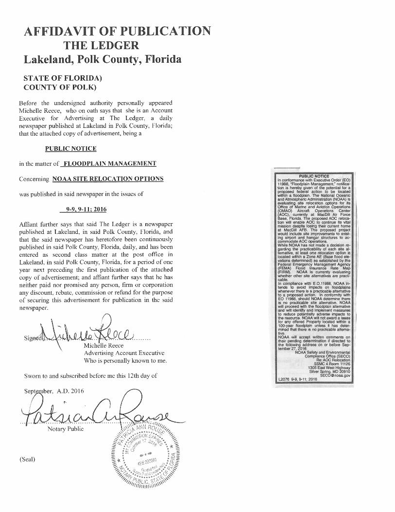
NOAA Office of Marine and Aviation Operations Aircraft Operations Center Relocation Attachment A
Attachment A
Finding of No Practicable Alternative (EO 11988)
NOAA Office of Marine and Aviation Operations Aircraft Operations Center Relocation Attachment A
351645 Tampa Bay Times
Published Daily STATE OF FLORIDA } ss COUNTY OF Hillsborough County, Pinellas Cou nty
Before the undersigned authority personally appeared Deird re Almeida who on oath says that he/she is Legal Clerk of the Tam pa Bay Times a daily newspaper printed in St. Petersburg, in Pinellas County, Florida; that the attached copy of advertisement, being a Legal Noti ce in the matter RE: NOAA site location was published in Tam pa Bay Times: 9/9/16, 9/11/16. in said newspaper in the issues of Bay link All Pinellas, Bay link Hillsborough
Sworn to and subscribed before me this 09/11/2016.
Personally known or produced identification
Ty pe of identification produced _
___
JEAN M MITOTES f ·t°Q>} MY COMMISSION # GG009269
EXPIRES July 06, 2020
(EO)
COMAOJ A AOC AOC
While NOAA has not made a decision regarding the practicability of each sitealternative, at least one relocation option is located within a Zone AE (Base floodelevations determined) as established by the Federal Emergency ManagementAgency (FEMA) Flood Insurance Rate Map (FIRM). NOAA is currently evaluatingwhether other site alternatives are practicable.
NOA A
whe11e EO 11988, NOA A
NOAA NOAA
NOAA Safety and Environmental Compliance Office (SECO)Re: AOC Relocation SSMC 4 Room 11126 1305 East West HighwaySilver Spring, MD 20910

Finding of No Practicable Alternative (EO 11988)
NOAA Office of Marine and Aviation Operations Aircraft Operations Center Relocation Attachment B
Attachment B

Finding of No Practicable Alternative (EO 11988)
IAKEIAND,
16259 (LAL) AIRPORT DIAGRAM AL 939(FMJ
LAKELAND UNDER RGNL FLORDA
rn '11 _IA
Ch
mr,n, N S! GI
8' CA 0 n -i
GI
.s C"'i N a.. w rn LO
AIRPORT DIAGRAM 16259
LAKELAND
IAKEIAND, FIORIDA UNDER RGNL (LAL)
ATIS 118.025 IAKELAND TOWER* 12'.5 236.775 Gt«>CON 121.4. l!J
JANUARY 2015 ANNUAL RATE OF CHANGE
o.1•w '---....l......---1.-28°00'N-'- '----+--..+-----1.--1--'---1--..
TWR +:ti :• 285\ •
.......:... / 111 • il
+-----1 --1-_.. , -+--_,'---....J.j
.., ARE -.STATION
•
:r. ' G
BEV A A 132 < 095.5°- 11499x150
'O
a: p p
D D E
m
27"59'N -'---'----'-E....1.... --1.... -.1----'- ELEV ti!! .. lil RWY 05 23 ... 130
PCN 35 F/A/X/T S-94, D·150,25-93
RWY 09 27 PCN 40 F/A/X/T S-105,D-170,25-175
A288 CAUTION:BE ALERT TO RUNWAY CROSSING ClEARANCES.
READBACK OF All RUNWAY HOIDING INS1RUCT10NS IS REQUIRED. i
82"02'W 82"01W