Embed Size (px)
Citation preview

:
National Climatic Data Center
DATA DOCUMENTATION
FOR
DATA SET 9956 (DSI-9956) DATSAV3 GLOBAL SURFACE HOURLY DATA
January 6, 2003
National Climatic Data Center 151 Patton Ave.
Asheville, NC 28801-5001 USA

: :
2:
Table of Contents
Topic Page Number
1. Abstract................................................... 3
2. Element Names and Definitions: ............................ 3
3. Start Date................................................ 51
4. Stop Date................................................. 51
5. Coverage.................................................. 51
6. How to order data......................................... 52
7. Archiving Data Center. ................................... 52
8. Technical Contact......................................... 52
9. Known Uncorrected Problems................................ 52
10. Quality Statement......................................... 52
11. Essential Companion Data Sets............................. 52
12. References................................................ 52

: :
3:
1. Abstract: The DATSAV3 database is built from the DATSAV2 database. The DATSAV2 Surface Database is composed of worldwide surface weather observations from about 10,000 currently active stations, collected and stored from sources such as the Automated Weather Network (AWN) and the Global Telecommunications System (GTS). Most collected observations are decoded at the Air Force Weather Agency (AFWA) at Offutt AFB, Nebraska, and then sent electronically to the USAF Combat Climatology Center (AFCCC), collocated with NCDC in the Federal Climate Complex in Asheville, NC. AFCCC builds the final database through decode, validation, and quality control software. All data are stored in a single ASCII format. The database is used in climatological applications by numerous DoD and civilian customers. DATSAV2 refers to the digital tape format in which decoded weather observations are stored. The DATSAV2 format conforms to Federal Information Processing Standards (FIPS). The DATSAV2 database includes data originating from various codes such as synoptic, airways, METAR (Meteorological Routine Weather Report), and SMARS (Supplementary Marine Reporting Station), as well as observations from automatic weather stations. The users handbook provides complete documentation for the database and its format. AFCCC sorts the observations into station-date-time order, validates each station number against the Air Weather Service Master Station Catalog (AWSMSC), runs several quality control programs, and then merges and sorts the data further into monthly and yearly station-ordered files. AFCCC then provides the data to the collocated National Climatic Data Center (NCDC). 2. Element Names and Definitions: Surface Observation files consist of observational datasets. Observational databases will be stored in ASCII files. Data item definitions for items transmitted are provided at the end of this preface, providing definition of data items, position number for mandatory data items, field lengths for variable data items, minimum/maximum values of transmitted data, and values for missing data items. Data Sequence - Data will be sequenced using the following data item order: 1. FIXED-WEATHER-STATION identifier 2. GEOPHYSICAL-POINT-OBSERVATION date 3. GEOPHYSICAL-POINT-OBSERVATION time 4. GEOPHYSICAL-POINT-OBSERVATION latitude coordinate 5. GEOPHYSICAL-POINT-OBSERVATION longitude coordinate 6. GEOPHYSICAL-POINT-OBSERVATION type surface report code 7. GEOPHYSICAL-REPORT-TYPE code Record Structure - Each record is of variable length and is comprised of a control and mandatory data section and may also contain additional, remarks and reject data sections. Maximum record size: 2,838 characters Maximum block length: 8,192 characters Control Data Section - The beginning of each record provides information about the report including date, time, and station location information. Data items will use positions identified in the applicable data item definition. The control data section is fixed length and is 54 characters long.
: :
4:
Mandatory Data Section - The mandatory data section contains meteorological information on the basic elements such as winds, visibility, and temperature. These are the most commonly reported parameters and are available most of the time. The mandatory data section is fixed length and is 45 characters long. Additional Data Section - Variable data is provided after the mandatory data. This additional data contains information of significance and/or which are received with a high degree of frequency. Identifiers are used to note when data is present in the record. If all data items in a group are missing, the entire group is not reported. If no groups are reported the section will be omitted. The additional data section is variable in length with a minimum of 0 characters and a maximum of 637 (634 characters plus a 3 character section identifier) characters. Note: Specific information (where applicable) pertaining to each variable group of data elements is provided in the data item definition Remarks Data Items - The non-decodable (remarks) data items are provided if they exist. Data items will vary in length and are identified in the applicable data item definition. The remarks section has a maximum length of 515 (512 characters plus a 3 character section identifier) characters. Element Quality Data Section - The element quality data section contains information on data that has been determined bad or suspect during quality control procedures. This section is variable in length and contains 16 characters for each erroneous or suspect parameter. The section has a minimum length of 0 characters and a maximum length of 1587 (1584 plus a 3 character section identifier) characters. Missing Values - Missing values for any non-signed item is filled ( i.e., 999). Missing values for any signed item is positive filled (i.e., +99999). Longitude and Latitude Coordinates - Longitudes will be reported with negative values representing longitudes west of 0 degrees, and latitudes will be negative south of the equator. ******************************************************************************
Control Data Section ****************************************************************************** POS: 1-4 TOTAL-VARIABLE-CHARACTERS - The number of characters in the
variable data section.
DOM: A general domain comprised of the characters in the ASCII character set.
MIN: 0000 MAX: 9999
NOTE: (assume this includes remarks add data, remarks etc) POS: 5-10 FIXED-WEATHER-STATION identifier - The identifier that
represents a FIXED-WEATHER-STATION.
MIN: 000000 MAX: 999999

: :
5:
DOM: A general domain comprised of the numeric characters (0-9).
COMMENT: This field includes all surface reporting stations, including ships, buoys, etc.
POS: 11-18 GEOPHYSICAL-POINT-OBSERVATION date - The date of a
GEOPHYSICAL-POINT-OBSERVATION.
MIN: 00000101 MAX: 99991231
DOM: A general domain comprised of integer values 0-9 in the format YYYYMMDD. YYYY can be any positive integer value; MM is restricted to values 01-12; and DD is restricted to values 01-31.
POS: 19-22 GEOPHYSICAL-POINT-OBSERVATION time - The time of a
GEOPHYSICAL-POINT-OBSERVATION based on Coordinated Universal Time Code (UTC).
MIN: 0000 MAX: 2359
DOM: A general domain comprised of integer values 0-9 in the format HHMM. HH is restricted to values 00-23; MM is restricted to values 00-59.
POS: 23-28 GEOPHYSICAL-POINT-OBSERVATION latitude coordinate – The
latitude coordinate of a GEOPHYSICAL-POINT-OBSERVATION where southern hemisphere is negative.
MIN: -90000 MAX: +90000 UNITS: Degrees SCALING FACTOR: 1000
DOM: A general domain comprised of the numeric characters (0-9), a plus sign(+), and a minus sign(-). Missing = +99999
POS: 29-35 GEOPHYSICAL-POINT-OBSERVATION longitude coordinate – The
longitude coordinate of a GEOPHYSICAL-POINT-OBSERVATION where values west from 000000 to 179999 are signed negative.
MIN: -179999 MAX: +180000 UNITS: Degrees SCALING FACTOR: 1000
DOM: A general domain comprised of the numeric characters (0-9), a plus sign(+), and a minus sign(-). Missing = +999999
POS: 36-40 GEOPHYSICAL-REPORT-TYPE code - The code that denotes the
type of geophysical surface observation.

: :
6:
DOM: A specific domain comprised of the characters in the ASCII character set. FM-12 = SYNOP Report of surface observation form a fixed land station FM-13 = SHIP Report of surface observation from a sea station FM-14 = SYNOP MOBIL Report of surface observation from a mobile land station FM-15 = METAR Aviation routine weather report FM-16 = SPECI Aviation selected special weather report FM-18 = BUOY Report of a buoy observation SAO = Airways report (includes record specials) SAOSP = Airways special report (excluding record specials) AERO = Aerological report AUTO = Report from an automatic station SY-AE = Synoptic and aero merged report SY-SA = Synoptic and airways merged report SY-MT = Synoptic and metar merged report SY-AU = Synoptic and auto merged report SA-AU = Airways and auto merged report S-S-A = Synoptic, airways and auto merged report BOGUS = Bogus report SMARS = Supplementary airways station report
POS: 41-45 GEOPHYSICAL-POINT-OBSERVATION elevation dimension – The
elevation of a GEOPHYSICAL-POINT-OBSERVATION relative to Mean Sea Level (MSL).
MIN: -0400 MAX: +8850 UNITS: Meters SCALING FACTOR: 1
DOM: A general domain comprised of the numeric characters (0-9), a minus sign(-), and a plus sign(+). Missing = +9999
POS: 46-50 FIXED-WEATHER-STATION call letter identifier – The
identifier that represents the call letters assigned to a FIXED-WEATHER-STATION.
DOM: A general domain comprised of the characters in the ASCII character set. Missing = 99999.
POS: 51-54 METEOROLOGICAL-POINT-OBSERVATION quality control process
name - The name of the quality control process applied to a weather observation.
DOM: A general domain comprised of the ASCII character set.
******************************************************************************
Mandatory Data Section ****************************************************************************** POS: 55-57 WIND-OBSERVATION direction angle - The angle, measured in a
clockwise direction, between true north and the direction from which the wind is blowing.

: :
7:
MIN: 001 MAX: 360 UNITS: Angular Degrees SCALING FACTOR: 1
DOM: A general domain comprised of the numeric characters (0-9). Missing = 999.
POS: 58-58 WIND-OBSERVATION direction quality code - The code that
denotes a quality status of a reported WIND-OBSERVATION direction angle.
DOM: A specific domain comprised of the characters in the ASCII character set.
0 = No check 1 = Good 2 = Suspect 3 = Erroneous 9 = Missing
POS: 59-59 WIND-OBSERVATION type code - The code that denotes the
character of the WIND-OBSERVATION.
DOM: A specific domain comprised of the characters in the ASCII character set. C: Calm N: Normal Q: Squall V: Variable 9: Missing
POS: 60-63 WIND-OBSERVATION speed rate - The rate of horizontal travel of air past a fixed point.
MIN: 0000 MAX: 0900 UNITS: meters per second SCALING FACTOR: 10
DOM: A general domain comprised of the numeric characters (0-9). Missing = 9999.
POS: 64-64 WIND-OBSERVATION speed quality code - The code that denotes
a quality status of a reported WIND-OBSERVATION speed rate.
DOM: A specific domain comprised of the characters in the ASCII character set. 0 = No check 1 = Good 2 = Suspect 3 = Erroneous 9 = Missing

: :
8:
POS: 65-69 SKY-CONDITION-OBSERVATION ceiling height dimension – The
height Above Ground Level (AGL) of the lowest cloud or obscuring phenomena layer aloft with 5/8 or more summation total sky cover, which may be predominantly opaque, or the vertical visibility into a surface-based obstruction.
MIN: 00000 MAX: 21000 UNITS: Meters SCALING FACTOR: 1
DOM: A general domain comprised of the numeric characters (0-9). 99999 = missing.
POS: 70-70 SKY-CONDTION-OBSERVATION ceiling quality code - The code
that denotes a quality status of a reported ceiling height dimension.
DOM: A specific domain comprised of the characters in the ASCII character set. 0 = No Check 1 = Good 2 = Suspect 3 = Erroneous 9 = Missing
POS: 71-71 SKY-CONDITION-OBSERVATION ceiling determination code – The
code that denotes the method used to determine the ceiling.
DOM: A specific domain comprised of the characters in the ASCII character set.
A: Aircraft B: Balloon C: Statistically derived E: Estimated M: Measured R: Radar W: Obscured 9: Missing
POS: 72-72 SKY-CONDITION-OBSERVATION CAVOK code - The code that represents whether the ‘Ceiling And Visibility Okay' (CAVOK) condition has been reported.
DOM: A specific domain comprised of the characters in the ASCII character set. N: No Y: Yes
POS: 73-78 VISIBILITY-OBSERVATION distance dimension - The horizontal distance at which an object can be seen and identified.
MIN: 000000
: :
9:
MAX: 160000 UNITS: Meters
DOM: A general domain comprised of the numeric characters (0-9). Missing = 999999
NOTE: Values greater than 1600 are entered as 1600 POS: 79-79 VISIBILITY-OBSERVATION distance quality code - The code that
denotes a quality status of a reported distance of a visibility observation.
DOM: A specific domain comprised of the characters in the ASCII character set. 0 = No check 1 = Good 2 = Suspect 3 = Erroneous 9 = Missing
POS: 80-80 VISIBILITY-OBSERVATION variability code - The code that
denotes whether or not the reported visibility is variable.
DOM: A specific domain comprised of the characters in the ASCII character set. N: Not variable V: Variable
POS: 81-81 VISIBILITY-OBSERVATION quality variability code - The code
that denotes a quality status of a reported VISIBILITY- OBSERVATION variability code.
DOM: A specific domain comprised of the characters in the ASCII character set. 0 = No check 1 = Good 2 = Suspect 3 = Erroneous 9 = Missing
POS: 82-86 AIR-TEMPERATURE-OBSERVATION air temperature – The
temperature of the air.
MIN: -0932 MAX: +0618 UNITS: Degrees Celsius SCALING FACTOR: 10
DOM: A general domain comprised of the numeric characters (0-9), a plus sign (+), and a minus sign(-). +9999 = missing.
POS: 87-87 AIR-TEMPERATURE-OBSERVATION air-temperature quality code-
The code that denotes a quality status of an AIR-

: :
10:
TEMPERATURE-OBSERVATION.
DOM: A specific domain comprised of the characters in the ASCII character set. 0 = No check 1 = Good 2 = Suspect 3 = Erroneous 9 = Missing
POS: 88-92 AIR-TEMPERATURE-OBSERVATION dew point temperature - The
temperature to which a given parcel of air must be cooled at constant pressure and water vapor content in order for saturation to occur.
MIN: -0982 MAX: +0368 UNITS: Degrees Celsius SCALING FACTOR: 10
DOM: A general domain comprised of the numeric characters (0-9), a plus sign(+), and a minus sign(-). +9999 = missing.
POS: 93-93 AIR-TEMPERATURE-OBSERVATION dew point quality code – The
code that denotes a quality status of the reported dew point temperature.
DOM: A specific domain comprised of the characters in the ASCII character set. 0 = No check 1 = Good 2 = Suspect 3 = Erroneous 9 = Missing
POS: 94-98 ATMOSPHERIC-PRESSURE-OBSERVATION sea level pressure rate –
The air pressure relative to Mean Sea Level (MSL).
MIN: 08600 MAX: 10900 UNITS: Hectopascals SCALING FACTOR: 10
DOM: A general domain comprised of the numeric characters (0-9). 99999 = missing.
POS: 99-99 ATMOSPHERIC-PRESSURE-OBSERVATION sea level pressure quality
code - The code that denotes a quality status of the sea level pressure of an ATMOSPHERIC-PRESSURE-OBSERVATION.
DOM: A specific domain comprised of the characters in the ASCII character set. 0 = No check 1 = Good

: :
11:
2 = Suspect 3 = Erroneous 9 = Missing
******************************************************************************
Additional Data Section ****************************************************************************** FLD LEN: 3 GEOPHYSICAL-POINT-OBSERVATION additional data identifier –
The identifier that denotes the beginning of the additional data section.
DOM: A specific domain comprised of the ASCII character set. ADD =Additional Data Section
FLD LEN: 3 LIQUID-PRECIPITATION occurrence identifier - The identifier
that represents an episode of LIQUID-PRECIPITATION.
DOM: A specific domain comprised of the characters in the ASCII character set.
AA1 - AA4 An indicator of up to 4 repeating fields of the following items: LIQUID-PRECIPITATION period quantity LIQUID-PRECIPITATION depth dimension LIQUID-PRECIPITATION trace code
FLD LEN: 2 LIQUID-PRECIPITATION period quantity - The quantity of time over which the LIQUID-PRECIPITATION was measured.
MIN: 00 MAX: 48 UNITS: Hours SCALING FACTOR: 1
DOM: A specific domain comprised of the characters in the ASCII character set. 99 = missing.
FLD LEN: 4 LIQUID-PRECIPITATION depth dimension - The depth of LIQUID-
PRECIPITATION that is measured at the time of an observation.
MIN: 0000 MAX: 2000 UNITS: millimeters SCALING FACTOR: 10
DOM: A general domain comprised of the numeric characters (0-9). 9999 = missing.
FLD LEN: 1 LIQUID-PRECIPITATION condition code - The code that denotes
whether a LIQUID-PRECIPITATION depth dimension was a trace value.
DOM: A specific domain comprised of the characters in the ASCII character set.

: :
12:
1:measurement impossible or inaccurate 2:Trace 9:Missing
FLD LEN: 3 PRECIPITATION-OBSERVATION-HISTORY identifier – The
identifier that indicates the occurrence of precipitation history information.
DOM: A specific domain comprised of the characters in the ASCII character set. AC1 An indicator of the following items: PRECIPITATION-OBSERVATION-HISTORY duration code PRECIPITATION-OBSERVATION-HISTORY characteristic code
FLD LEN: 1 PRECIPITATION-OBSERVATION-HISTORY duration code - The code
that denotes the duration of precipitation.
DOM: A specific domain comprised of the characters in the ASCII character set. 0 = Lasted less than 1 hour 1 = Lasted 1 - 3 hours 2 = Lasted 3 - 6 hours 3 = Lasted more than 6 hours 9 = missing
FLD LEN: 1 PRECIPITATION-OBSERVATION-HISTORY characteristic code – The code that denotes whether precipitation is continuous or intermittent.
DOM: A specific domain comprised of the characters in the ASCII character set.
C = Continuous I = Intermittent 9 = missing
FLD LEN: 3 PRECIPITATION-BOGUS-OBSERVATION identifier - The identifier that represents a PRECIPITATION-BOGUS-OBSERVATION.
DOM: A specific domain comprised of the characters in the ASCII character set.
AG1 An indicator of the occurrence of the following items: PRECIPITATION-OBSERVATION discrepancy code PRECIPITATION-OBSERVATION estimated water equivalency dimension
FLD LEN: 1 PRECIPITATION-BOGUS-OBSERVATION discrepancy code - The code
that denotes the type of discrepancy between a PRECIPITATION-OBSERVATION and other related observations at the same location.
DOM: A specific domain comprised of the characters in the ASCII character set.
: :
13:
0: Reported amount of precipitation and reported weather agree 1: Precipitation missing or not reported and none inferred by weather 2: Precipitation missing, but precipitation inferred by weather 3: Precipitation reported, but none inferred by weather 4: Zero precipitation reported, but precipitation inferred by weather 5: Zero precipitation reported, no precipitation inferred and precipitation not occurring at the reporting station 9: Missing
FLD LEN: 3 PRECIPITATION-BOGUS-OBSERVATION estimated water equivalency
dimension - The estimated depth of precipitation in water equivalency for a 3-hour synoptic period.
MIN: 000 MAX: 998 UNITS: millimeters SCALING FACTOR: 1
DOM: A general domain comprised of the numeric characters (0-9). 999 = missing.
FLD LEN: 3 SNOW-DEPTH identifier - The identifier that denotes the
start of a SNOW-DEPTH data section.
DOM: A specific domain comprised of the characters in the ASCII character set.
AJ1 SNOW-DEPTH dimension SNOW-DEPTH condition code SNOW-DEPTH equivalent water depth dimension SNOW-DEPTH equivalent water condition code
FLD LEN: 4 SNOW-DEPTH dimension - The depth of snow and ice on the ground.
MIN: 0000 MAX: 1200 UNITS: centimeters SCALING FACTOR: 1
DOM: A general domain comprised of the numeric characters (0-9). 9999 = missing.
FLD LEN: 1 SNOW-DEPTH condition code - The code that denotes specific
conditions associated with the measurement of snow in a PRECIPITATION-OBSERVATION.
DOM: A specific domain comprised of the characters in the ASCII character set. 1: Measurement impossible or inaccurate

: :
14:
2: Snow cover not continuous 3: Trace 9: Missing
FLD LEN: 6 SNOW-DEPTH equivalent water depth dimension - The depth of
the liquid content of solid precipitation that has accumulated on the ground.
MIN: 000000 MAX: 120000 UNITS: millimeters SCALING FACTOR: 10
DOM: A general domain comprised of the numeric characters (0-9). 999999 = missing.
FLD LEN 1 SNOW-DEPTH equivalent water condition code - The code that
denotes specific conditions associated with the measurement of the SNOW-DEPTH.
DOM: A specific domain comprised of the characters in the ASCII character set. 1: Measurement impossible or inaccurate 2: Trace 9: Missing
FLD LEN: 3 HAIL identifier - The identifier that denotes the start of a
HAIL data section.
DOM: A specific domain comprised of the characters in the ASCII character set. HL1 An indicator of the occurrence of the following item: HAIL dimension
FLD LEN: 3 HAIL size - The diameter of the largest hailstone observed.
MIN: 000 MAX: 200 UNITS: Centimeters SCALING FACTOR: 10 DOM: A general domain comprised of the numeric characters (0-9).
FLD LEN: 3 SNOW-ACCUMULATION occurrence identifier - The identifier that
represents an episode of SNOW-ACCUMULATION.
DOM: A specific domain comprised of the characters in the ASCII character set. AL1 - AL4 An indicator of up to 4 repeating fields of the following items:
SNOW-ACCUMULATION six hour depth dimension SNOW-ACCUMULATION condition code
: :
15:
SNOW-ACCUMULATION period quantity FLD LEN: 2 SNOW-ACCUMULATION period quantity - The quantity of time
over which the SNOW-ACCUMULATION occurred.
MIN: 00 MAX: 72 UNITS: Hours SCALING FACTOR: 1
DOM: A general domain comprised of the characters in the ASCII character set. 99 = missing.
FLD LEN: 3 SNOW-ACCUMULATION depth dimension - The depth of a SNOW-
ACCUMULATION.
MIN: 000 MAX: 500 UNITS: centimeters SCALING FACTOR: 1
DOM: A general domain comprised of the numeric characters (0-9). 999 = Missing.
FLD LEN: 1 SNOW-ACCUMULATION condition code - The code that denotes
specific conditions associated with the measurement of the depth of a SNOW-ACCUMULATION.
DOM: A specific domain comprised of the characters in the ASCII character set. 1: Measurement impossible or inaccurate 2: Snow cover not continuous 3: Trace 9: Missing
FLD LEN: 3 PRESENT-WEATHER-OBSERVATION manual occurrence identifier –
The identifier that signifies the reporting of present weather.
DOM: A specific domain comprised of the ASCII characters. MW1 = first weather reported MW2 = second weather reported MW3 = third weather reported MW4 = fourth weather reported MW5 = fifth weather reported MW6 = sixth weather reported MW7 = seventh weather reported An indicator of up to 7 repeating fields of the following items: PRESENT-WEATHER-OBSERVATION manual atmospheric condition code. PRESENT-WEATHER-OBSERVATION quality manual atmospheric condition code
: :
16:
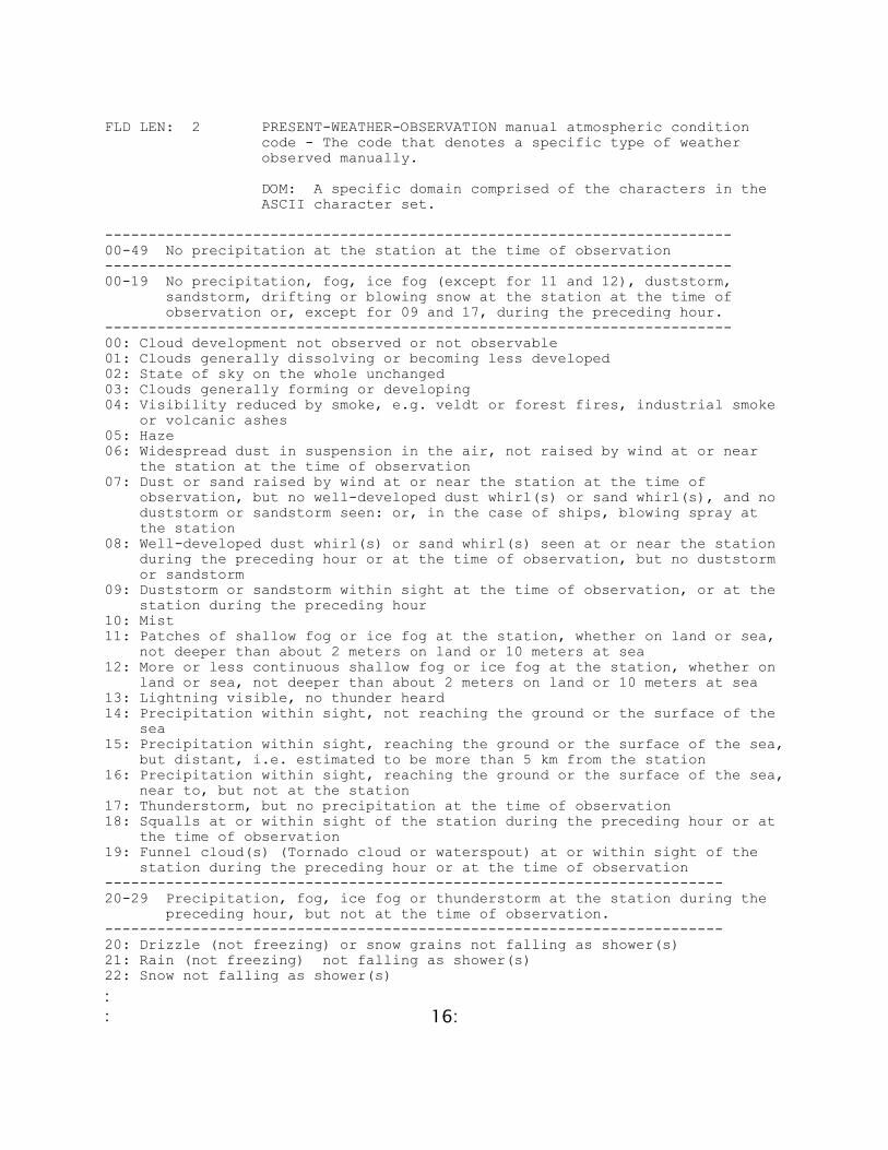
FLD LEN: 2 PRESENT-WEATHER-OBSERVATION manual atmospheric condition
code - The code that denotes a specific type of weather observed manually.
DOM: A specific domain comprised of the characters in the ASCII character set.
------------------------------------------------------------------------ 00-49 No precipitation at the station at the time of observation ------------------------------------------------------------------------ 00-19 No precipitation, fog, ice fog (except for 11 and 12), duststorm,
sandstorm, drifting or blowing snow at the station at the time of observation or, except for 09 and 17, during the preceding hour.
------------------------------------------------------------------------ 00: Cloud development not observed or not observable 01: Clouds generally dissolving or becoming less developed 02: State of sky on the whole unchanged 03: Clouds generally forming or developing 04: Visibility reduced by smoke, e.g. veldt or forest fires, industrial smoke or volcanic ashes 05: Haze 06: Widespread dust in suspension in the air, not raised by wind at or near the station at the time of observation 07: Dust or sand raised by wind at or near the station at the time of observation, but no well-developed dust whirl(s) or sand whirl(s), and no duststorm or sandstorm seen: or, in the case of ships, blowing spray at the station 08: Well-developed dust whirl(s) or sand whirl(s) seen at or near the station during the preceding hour or at the time of observation, but no duststorm or sandstorm 09: Duststorm or sandstorm within sight at the time of observation, or at the station during the preceding hour 10: Mist 11: Patches of shallow fog or ice fog at the station, whether on land or sea, not deeper than about 2 meters on land or 10 meters at sea 12: More or less continuous shallow fog or ice fog at the station, whether on land or sea, not deeper than about 2 meters on land or 10 meters at sea 13: Lightning visible, no thunder heard 14: Precipitation within sight, not reaching the ground or the surface of the sea 15: Precipitation within sight, reaching the ground or the surface of the sea, but distant, i.e. estimated to be more than 5 km from the station 16: Precipitation within sight, reaching the ground or the surface of the sea, near to, but not at the station 17: Thunderstorm, but no precipitation at the time of observation 18: Squalls at or within sight of the station during the preceding hour or at the time of observation 19: Funnel cloud(s) (Tornado cloud or waterspout) at or within sight of the station during the preceding hour or at the time of observation ----------------------------------------------------------------------- 20-29 Precipitation, fog, ice fog or thunderstorm at the station during the
preceding hour, but not at the time of observation. ----------------------------------------------------------------------- 20: Drizzle (not freezing) or snow grains not falling as shower(s) 21: Rain (not freezing) not falling as shower(s) 22: Snow not falling as shower(s)
: :
17:
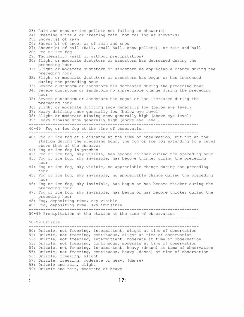
23: Rain and snow or ice pellets not falling as shower(s) 24: Freezing drizzle or freezing rain not falling as shower(s) 25: Shower(s) of rain 26: Shower(s) of snow, or of rain and snow 27: Shower(s) of hail (Hail, small hail, snow pellets), or rain and hail 28: Fog or ice fog 29: Thunderstorm (with or without precipitation) 30: Slight or moderate duststorm or sandstorm has decreased during the preceding hour 31: Slight or moderate duststorm or sandstorm no appreciable change during the preceding hour 32: Slight or moderate duststorm or sandstorm has begun or has increased during the preceding hour 33: Severe duststorm or sandstorm has decreased during the preceding hour 34: Severe duststorm or sandstorm no appreciable change during the preceding hour 35: Severe duststorm or sandstorm has begun or has increased during the preceding hour 36: Slight or moderate drifting snow generally low (below eye level) 37: Heavy drifting snow generally low (below eye level) 38: Slight or moderate blowing snow generally high (above eye level) 39: Heavy blowing snow generally high (above eye level) ----------------------------------------------------------------------- 40-49 Fog or ice fog at the time of observation ----------------------------------------------------------------------- 40: Fog or ice fog at a distance at the time of observation, but not at the station during the preceding hour, the fog or ice fog extending to a level above that of the observer 41: Fog or ice fog in patches 42: Fog or ice fog, sky visible, has become thinner during the preceding hour 43: Fog or ice fog, sky invisible, has become thinner during the preceding hour 44: Fog or ice fog, sky visible, no appreciable change during the preceding hour 45: Fog or ice fog, sky invisible, no appreciable change during the preceding hour 46: Fog or ice fog, sky invisible, has begun or has become thicker during the preceding hour 47: Fog or ice fog, sky invisible, has begun or has become thicker during the preceding hour 48: Fog, depositing rime, sky visible 49: Fog, depositing rime, sky invisible ----------------------------------------------------------------------- 50-99 Precipitation at the station at the time of observation ----------------------------------------------------------------------- 50-59 Drizzle ----------------------------------------------------------------------- 50: Drizzle, not freezing, intermittent, slight at time of observation 51: Drizzle, not freezing, continuous, slight at time of observation 52: Drizzle, not freezing, intermittent, moderate at time of observation 53: Drizzle, not freezing, continuous, moderate at time of observation 54: Drizzle, not freezing, intermittent, heavy (dense) at time of observation 55: Drizzle, not freezing, continuous, heavy (dense) at time of observation 56: Drizzle, freezing, slight 57: Drizzle, freezing, moderate or heavy (dense) 58: Drizzle and rain, slight 59: Drizzle and rain, moderate or heavy

: :
18:
----------------------------------------------------------------------- 60-69: Rain ----------------------------------------------------------------------- 60: Rain, not freezing, intermittent, slight at time of observation 61: Rain, not freezing, continuous, slight at time of observation 62: Rain, not freezing, intermittent, moderate at time of observation 63: Rain, not freezing, continuous, moderate at time of observation 64: Rain, not freezing, intermittent, heavy at time of observation 65: Rain, not freezing, continuous, heavy at time of observation 66: Rain, freezing, slight 67: Rain, freezing, moderate or heavy 68: Rain or drizzle and snow, slight 69: Rain or drizzle and snow, moderate or heavy ----------------------------------------------------------------------- 70-79 Solid precipitation not in showers ----------------------------------------------------------------------- 70: Intermittent fall of snowflakes, slight at time of observation 71: Continuous fall of snowflakes, slight at time of observation 72: Intermittent fall of snowflakes, moderate at time of observation 73: Continuous fall of snowflakes, moderate at time of observation 74: Intermittent fall of snowflakes, heavy at time of observation 75: Continuous fall of snowflakes, heavy at time of observation 76: Diamond dust (with or without fog) 77: Snow grains (with or without fog) 78: Isolated star-like snow crystals (with or without fog) 79: Ice pellets ----------------------------------------------------------------------- 80-99 Showery precipitation, or precipitation with current or recent
thunderstorm. ----------------------------------------------------------------------- 80: Rain shower(s), slight 81: Rain shower(s), moderate or heavy 82: Rain shower(s), violent 83: Shower(s) of rain and snow mixed, slight 84: Shower(s) of rain and snow mixed, moderate or heavy 85: Show shower(s), slight 86: Snow shower(s), moderate or heavy 87: Shower(s) of snow pellets or small hail, with or without rain or rain and snow mixed, slight 88: Shower(s) of snow pellets or small hail, with or without rain or rain and snow mixed, moderate or heavy 89: Shower(s) of hail (hail, small hail, snow pellets) , with or without rain or rain and snow mixed, not associated with thunder, slight 90: Shower(s) of hail (hail, small hail, snow pellets), with or without rain or rain and snow mixed, not associated with thunder, moderate or heavy 91: Slight rain at time of observation, thunderstorm during the preceding hour but not at time of observation 92: Moderate or heavy rain at time of observation, thunderstorm during the preceding hour but not at time of observation 93: Slight snow, or rain and snow mixed or hail (Hail, small hail, snow pellets), at time of observation, thunderstorm during the preceding hour but not at time of observation 94: Moderate or heavy snow, or rain and snow mixed or hail(Hail, small hail, snow pellets) at time of observation, thunderstorm during the preceding hour but not at time of observation 95: Thunderstorm, slight or moderate, without hail (Hail, small hail, snow pellets), but with rain and/or snow at time of observation, thunderstorm

: :
19:
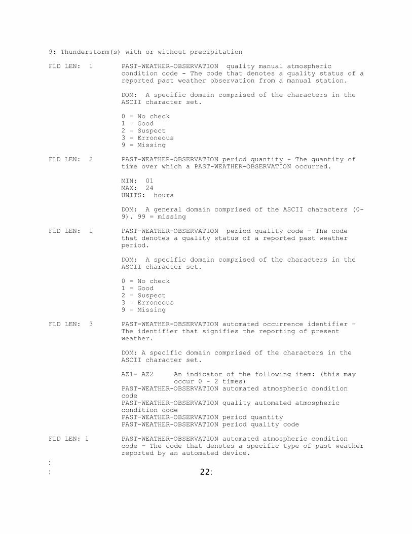
at time of observation 96: Thunderstorm, slight or moderate, with hail (hail, small hail, snow pellets) at time of observation, thunderstorm at time of observation 97: Thunderstorm, heavy, without hail (Hail, small hail, snow pellets), but with rain and/or snow at time of observation, thunderstorm at time of observation 98: Thunderstorm combined with duststorm or sandstorm at time of observation, thunderstorm at time of observation 99: Thunderstorm, heavy, with hail (Hail, small hail, snow pellets) at time of observation, thunderstorm at time of observation FLD LEN: 1 PRESENT-WEATHER-OBSERVATION quality manual atmospheric
condition code - The code that denotes a quality status of a reported present weather observation from a manual station.
DOM: A specific domain comprised of the characters in the ASCII character set.
0 = No check 1 = Good 2 = Suspect 3 = Erroneous 9 = Missing FLD LEN: 3 PRESENT-WEATHER-OBSERVATION automated occurrence identifier-
The identifier that signifies the reporting of present weather.
DOM: A specific domain comprised of the ASCII characters. AW1 = first automated weather report PRESENT-WEATHER-OBSERVATION automated atmospheric condition code. PRESENT-WEATHER-OBSERVATION quality automated atmospheric condition code
FLD LEN: 2 PRESENT-WEATHER-OBSERVATION automated atmospheric condition
code - The code that denotes a specific type of weather reported by an automated device.
DOM: A specific domain comprised of the characters in the ASCII character set.
00: No significant weather observed 01: Clouds generally dissolving or becoming less developed 02: State of sky on the whole unchanged during the past hour 03: Clouds generally forming or developing during the past hour 04: Haze, smoke, or dust in suspension in the air, visibility equal to or greater than 1km 05: Smoke 10: Mist 11: Diamond dust 12: Distant lightning 18: Squalls (Code figures 20-26 are used to report precipitation, fog, or thunderstorm at the station during the preceding hour, but not at the time of observation.)

: :
20:
20: Fog 21: Precipitation 22: Drizzle (not freezing) or snow grains 23: Rain (not freezing) 24: Snow 25: Freezing drizzle or freezing rain 26: Thunderstorm (with or without precipitation) 27: Blowing or drifting snow or sand 28: Blowing or drifting snow or sand, visibility equal to or greater than 1 km 29: Blowing or drifting snow or sand, visibility less than 1 km 30: Fog 31: Fog or ice fog in patches 32: Fog or ice fog, has become thinner during the past hour 33: Fog or ice fog, no appreciable change during the past hour 34: Fog or ice fog, has begun or become thicker during the past hour 35: Fog, depositing rime 40: Precipitation 41: Precipitation, slight or moderate 42: Precipitation, heavy 43: Liquid precipitation, slight or moderate 44: Liquid precipitation, heavy 45: Solid precipitation, slight or moderate 46: Solid precipitation, heavy 47: Freezing precipitation, slight or moderate 48: Freezing precipitation, heavy 50: Drizzle 51: Drizzle, not freezing, slight 52: Drizzle, not freezing, moderate 53: Drizzle, not freezing, heavy 54: Drizzle, freezing, slight 55: Drizzle, freezing, moderate 56: Drizzle, freezing, heavy 57: Drizzle and rain, slight 58: Drizzle and rain, moderate or heavy 60: Rain 61: Rain, not freezing, slight 62: Rain, not freezing, moderate 63: Rain, not freezing, heavy 64: Rain, freezing, slight 65: Rain, freezing, moderate 66: Rain, freezing, heavy 67: Rain or drizzle and snow, slight 68: Rain or drizzle and snow, moderate or heavy 70: Snow 71: Snow, slight 72: Snow, moderate 73: Snow, heavy 74: Ice pellets, slight 75: Ice pellets, moderate 76: Ice pellets, heavy 80: Showers or intermittent precipitation 81: Rain showers or intermittent rain, slight 82: Rain showers or intermittent rain, moderate 83: Rain showers or intermittent rain, heavy 84: Rain showers or intermittent rain, violent 85: Snow showers or intermittent rain, slight

: :
21:
86: Snow showers or intermittent rain, moderate 87: Snow showers or intermittent rain, heavy 90: Thunderstorm 91: Thunderstorm, slight or moderate, with no precipitation 92: Thunderstorm, slight or moderate, with rain showers and/or snow showers 93: Thunderstorm, slight or moderate, with hail 94: Thunderstorm, heavy, with no precipitation 95: Thunderstorm, heavy, with rain showers and/or snow 96: Thunderstorm, heavy, with hail 99: Tornado FLD LEN: 1 PRESENT-WEATHER-OBSERVATION quality automated atmospheric
condition code - The code that denotes a quality status of a reported present weather observation from an automated station.
DOM: A specific domain comprised of the characters in the ASCII character set. 0 = No check
1 = Good 2 = Suspect 3 = Erroneous 9 = Missing FLD LEN: 3 PAST-WEATHER-OBSERVATION manual occurrence identifier – The
identifier that signifies the reporting of past weather.
DOM: A specific domain comprised of the characters in the ASCII character set.
AY1 - AY2 An indicator of up to 2 repeating fields of the following item: PAST-WEATHER-OBSERVATION manual atmospheric condition code PAST-WEATHER-OBSERVATION quality manual atmospheric condition code PAST-WEATHER-OBSERVATION period quantity PAST-WEATHER-OBSERVATION period quality code
FLD LEN: 1 PAST-WEATHER-OBSERVATION manual atmospheric condition code-
The code that denotes a specific type of past weather observed manually.
DOM: A specific domain comprised of the characters in the ASCII character set.
Domain Value ID: Domain Value Definition Text 0: Cloud covering 1/2 or less of the sky throughout the appropriate period 1: Cloud covering more than 1/2 of the sky during part of the appropriate period and covering 1/2 or less during part of the period 2: Cloud covering more than 1/2 of the sky throughout the appropriate period 3: Sandstorm, duststorm or blowing snow 4: Fog or ice fog or thick haze 5: Drizzle 6: Rain 7: Snow, or rain and snow mixed 8: Shower(s)
: :
22:
9: Thunderstorm(s) with or without precipitation FLD LEN: 1 PAST-WEATHER-OBSERVATION quality manual atmospheric
condition code - The code that denotes a quality status of a reported past weather observation from a manual station.
DOM: A specific domain comprised of the characters in the ASCII character set.
0 = No check 1 = Good 2 = Suspect 3 = Erroneous 9 = Missing FLD LEN: 2 PAST-WEATHER-OBSERVATION period quantity - The quantity of
time over which a PAST-WEATHER-OBSERVATION occurred.
MIN: 01 MAX: 24 UNITS: hours
DOM: A general domain comprised of the ASCII characters (0- 9). 99 = missing
FLD LEN: 1 PAST-WEATHER-OBSERVATION period quality code - The code
that denotes a quality status of a reported past weather period.
DOM: A specific domain comprised of the characters in the ASCII character set.
0 = No check 1 = Good 2 = Suspect 3 = Erroneous 9 = Missing FLD LEN: 3 PAST-WEATHER-OBSERVATION automated occurrence identifier –
The identifier that signifies the reporting of present weather.
DOM: A specific domain comprised of the characters in the ASCII character set.
AZ1- AZ2 An indicator of the following item: (this may occur 0 - 2 times) PAST-WEATHER-OBSERVATION automated atmospheric condition code PAST-WEATHER-OBSERVATION quality automated atmospheric condition code PAST-WEATHER-OBSERVATION period quantity PAST-WEATHER-OBSERVATION period quality code
FLD LEN: 1 PAST-WEATHER-OBSERVATION automated atmospheric condition
code - The code that denotes a specific type of past weather reported by an automated device.
: :
23:
DOM: A specific domain comprised of the characters in the ASCII character set.
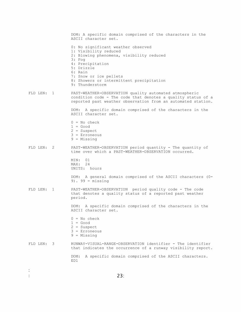
0: No significant weather observed 1: Visibility reduced 2: Blowing phenomena, visibility reduced 3: Fog 4: Precipitation 5: Drizzle 6: Rain 7: Snow or ice pellets 8: Showers or intermittent precipitation 9: Thunderstorm
FLD LEN: 1 PAST-WEATHER-OBSERVATION quality automated atmospheric
condition code - The code that denotes a quality status of a reported past weather observation from an automated station.
DOM: A specific domain comprised of the characters in the ASCII character set.
0 = No check 1 = Good 2 = Suspect 3 = Erroneous 9 = Missing FLD LEN: 2 PAST-WEATHER-OBSERVATION period quantity - The quantity of
time over which a PAST-WEATHER-OBSERVATION occurred.
MIN: 01 MAX: 24 UNITS: hours
DOM: A general domain comprised of the ASCII characters (0- 9). 99 = missing
FLD LEN: 1 PAST-WEATHER-OBSERVATION period quality code - The code
that denotes a quality status of a reported past weather period.
DOM: A specific domain comprised of the characters in the ASCII character set.
0 = No check 1 = Good 2 = Suspect 3 = Erroneous 9 = Missing FLD LEN: 3 RUNWAY-VISUAL-RANGE-OBSERVATION identifier - The identifier
that indicates the occurrence of a runway visibility report.
DOM: A specific domain comprised of the ASCII characters. ED1

: :
24:
FLD LEN: 2 RUNWAY-VISUAL-RANGE-OBSERVATION direction angle - The angle as measured from magnetic north to the runway along which the visibility is observed.
MIN: 01 MAX: 36 UNITS: Tens of degrees SCALING FACTOR: 1/10
DOM: A general domain comprised of the characters in the ASCII character set. 99 = missing
FLD LEN: 1 RUNWAY-VISUAL-RANGE-OBSERVATION runway designator code – The
code that denotes the left, right or center runway as the one to which the visibility applies.
DOM: A specific domain comprised of the ASCII characters: L = left C = center R = right U = unknown
FLD LEN: 4 RUNWAY-VISUAL-RANGE-OBSERVATION visibility dimension - The
dimension of the horizontal distance that can be seen along the runway.
MIN: 0000 MAX: 5000 UNITS: meters
DOM: A general domain comprised of the ASCII characters (0- 9). 9999 = missing
FLD LEN: 3 SKY-COVER-LAYER identifier - The identifier that represents
a SKY-COVER-LAYER.
DOM: A specific domain comprised of the characters in the ASCII character set.
GA1-GA6 An indicator of up to 6 repeating fields of the following items:
SKY-COVER-LAYER coverage code SKY-COVER-LAYER base height dimension SKY-COVER-LAYER cloud type code
FLD LEN: 2 SKY-COVER-LAYER coverage code - The code that denotes the
fraction of the total celestial dome covered by a SKY-COVER- LAYER.
DOM: A specific domain comprised of the characters in the ASCII character set. 00: None, SKC or CLR
01: One okta - 1/10 or less but not zero 02: Two oktas - 2/10 - 3/10, or FEW
03: Three oktas - 4/10

: :
25:
04: Four oktas - 5/10, or SCT 05: Five oktas - 6/10 06: Six oktas - 7/10 - 8/10 07: Seven oktas - 9/10 or more but not 10/10, or BKN 08: Eight oktas - 10/10, or OVC 09: Sky obscured, or cloud amount cannot be estimated 10: Partial obscuration 99: Missing FLD LEN: 6 SKY-COVER-LAYER base height dimension - The height relative
to a VERTICAL-REFERENCE-DATUM of the lowest surface of a cloud.
MIN: -00400 MAX: +35000 UNITS: Meters SCALING FACTOR: 1
DOM: A general domain comprised of the numeric characters (0-9). +99999 = missing
FLD LEN: 2 SKY-COVER-LAYER cloud type code - The code that denotes the
classification of the clouds that comprise a SKY-COVER- LAYER.
DOM: A specific domain comprised of the characters in the ASCII character set. 00: Cirrus (Ci) 01: Cirrocumulus (Cc) 02: Cirrostratus (Cs) 03: Altocumulus (Ac) 04: Altostratus (As) 05: Nimbostratus (Ns) 06: Stratocumulus (Sc) 07: Stratus (St) 08: Cumulus (Cu) 09: Cumulonimbus (Cb) 10: Cloud not visible owing to darkness, fog, dust storm, sandstorm, or other analogous phenomena 99: Missing
FLD LEN: 3 SKY-CONDITION-OBSERVATION identifier - An indicator that
denotes the start of a SKY-CONDITION-OBSERVATION data group.
DOM: A specific domain comprised of the characters in the ASCII character set. GF1 : An indicator of the occurrence of the following data items:
SKY-CONDITION-OBSERVATION total coverage code SKY-CONDITION-OBSERVATION quality total coverage code SKY-CONDITION-OBSERVATION total lowest cloud cover code SKY-CONDITION-OBSERVATION quality total lowest cloud cover code SKY-CONDITION-OBSERVATION low cloud genus code
: :
26:
SKY-CONDITION-OBSERVATION quality low cloud genus code SKY-CONDITION-OBSERVATION lowest cloud base height dimension SKY-CONDITION-OBSERVATION lowest cloud base height quality code SKY-CONDITION-OBSERVATION mid cloud genus code SKY-CONDITION-OBSERVATION quality mid cloud genus code SKY-CONDITION-OBSERVATION high cloud genus code SKY-CONDITION-OBSERVATION quality high cloud genus code
FLD LEN: 2 SKY-CONDITION-OBSERVATION total coverage code - The code
that denotes the fraction of the total celestial dome covered by clouds or other obscuring phenomena.
DOM: A specific domain comprised of the characters in the ASCII character set.
00: None, SKC or CLR 01: One okta - 1/10 or less but not zero 02: Two oktas - 2/10 - 3/10, or FEW 03: Three oktas - 4/10 04: Four oktas - 5/10, or SCT 05: Five oktas - 6/10 06: Six oktas - 7/10 - 8/10 07: Seven oktas - 9/10 or more but not 10/10, or BKN 08: Eight oktas - 10/10, or OVC 09: Sky obscured, or cloud amount cannot be estimated 10: Partial obscuration 99: Missing FLD LEN: 1 SKY-CONDITION-OBSERVATION quality total coverage code- The
code that denotes a quality status of a reported total sky coverage code.
DOM: A specific domain comprised of the characters in the ASCII character set. 0 = No check
1 = Good 2 = Suspect 3 = Erroneous 9 = Missing FLD LEN: 2 SKY-CONDITION-OBSERVATION total lowest cloud cover code –
The code that represents the fraction of the celestial dome covered by all low clouds present; if no low clouds are present, the code denotes the fraction covered by all middle level clouds present.
DOM: A specific domain comprised of the characters in the ASCII character set.
00: None 01: One okta or 1/10 or less but not zero 02: Two oktas or 2/10-3/10 03: Three oktas or 4/10 04: Four oktas or 5/10 05: Five oktas or 6/10

: :
27:
06: Six oktas or 7/10 - 8/10 07: Seven oktas or 9/10 or more but not 10/10 08: Eight oktas or 10/10 09: Sky obscured, or cloud amount cannot be estimated 99: Missing FLD LEN: 1 SKY-CONDITION-OBSERVATION quality total lowest cloud cover
code - The code that denotes a quality status of a reported total lowest cloud cover code.
DOM: A specific domain comprised of the characters in the ASCII character set.
0 = No check 1 = Good 2 = Suspect 3 = Erroneous 9 = Missing FLD LEN: 2 SKY-CONDITION-OBSERVATION low cloud genus code - The code
that denotes a type of low cloud.
DOM: A specific domain comprised of the characters in the ASCII Character set. 00: No low clouds 01: Cumulus humulis or Cumulus fractus other than of bad weather or both
02: Cumulus mediocris or congestus, with or without Cumulus of species fractus or humulis or Stratocumulus all having bases at the same level
03: Cumulonimbus calvus, with or without Cumulus, Stratocumulus or Stratus 04: Stratocumulus cumulogenitus 05: Stratocumulus other than Stratocumulus cumulogenitus 06: Stratus nebulosus or Stratus fractus other than of bad
weather, or both 07: Stratus fractus or Cumulus fractus of bad weather, or
both (pannus) usually below Altostratus or Nimbostratus 08: Cumulus and Stratocumulus other than Stratocumulus
cumulogenitus, with bases at different levels 09: Cumulonimbus capillatus (often with an anvil), with or
without Cumulonimbus calvus, Cumulus, Stratocumulus, Stratus or pannus 99: Missing
FLD LEN: 1 SKY-CONDITION-OBSERVATION quality low cloud genus code – The
code that denotes a quality status of a reported low cloud type.
DOM: A specific domain comprised of the characters in the ASCII character set.
0 = No check 1 = Good 2 = Suspect 3 = Erroneous

: :
28:
9 = Missing FLD LEN: 5 SKY-CONDITION-OBSERVATION lowest cloud base height dimension
- The height Above Ground Level (AGL) of the base of the lowest cloud.
MIN: 00000 MAX: 21000 UNITS: Meters SCALING FACTOR: 1
DOM: A general domain comprised of the numeric characters (0-9). 99999 = missing.
FLD LEN: 1 SKY-CONDITION-OBSERVATION lowest cloud base height quality
code - The code that denotes a quality status of a lowest cloud base height.
DOM: A specific domain comprised of the characters in the ASCII character set.
0 = No check 1 = Good 2 = Suspect 3 = Erroneous 9 = Missing FLD LEN: 2 SKY-CONDITION-OBSERVATION mid cloud genus code - The code
that denotes a type of middle level cloud.
DOM: A specific domain comprised of the characters in the ASCII character set.
00: No middle clouds 01: Altostratus translucidus 02: Altostratus opacus or Nimbostratus 03: Altocumulus translucidus at a single level 04: Patches (often lenticular) of Altocumulus translucidus,
continually changing and occurring at one or more levels 05: Altocumulus translucidus in bands, or one or more layers
of Altocumulus translucidus or opacus, progressively invading the sky; these Altocumulus clouds generally thicken as a whole
06: Altocumulus cumulogentis (or cumulonimbogentus) 07: Altocumulus translucidus or opacus in two or more
layers, or Altocumulus opacus in a single layer, not progressively invading the sky, or Altocumulus with Altostratus or Nimbostratus
08: Altocumulus castellanus or floccus 09: Altocumulus of a chaotic sky; generally at several
levels 99: Missing FLD LEN: 1 SKY-CONDITION-OBSERVATION quality mid cloud genus code – The
code that denotes a quality status of a reported mid cloud type.

: :
29:
DOM: A specific domain comprised of the characters in the ASCII character set.
0 = No check 1 = Good 2 = Suspect 3 = Erroneous 9 = Missing FLD LEN: 2 SKY-CONDITION-OBSERVATION high cloud genus code - The code
that denotes a type of high cloud.
DOM: A specific domain comprised of the characters in the ASCII character set. 00: No High Clouds 01: Cirrus fibratus, sometimes uncinus, not progressively invading the sky 02: Cirrus spissatus, in patches or entangled sheaves, which usually do not increase and sometimes seem to be the remains of the upper part of a Cumulonimbus; or Cirrus castellanus or floccus 03: Cirrus spissatus cumulonimbogentus 04: Cirrus unicinus or fibratus, or both, progressively invading the sky; they generally thicken as a whole 05: Cirrus (often in bands) and Cirrostratus, or Cirrostratus alone, progressively invading the sky; they generally thicken as a whole, but the continuous veil does not reach 45 degrees above the horizon 06: Cirrus (often in bands) and Cirrostratus, or Cirrostratus alone, progressively invading the sky; they generally thicken as a whole; the continuous veil extends more than 45 degrees above the horizon, without the sky being totally covered. 07: Cirrostratus covering the whole sky 08: Cirrostratus not progressively invading the sky and not entirely covering it 09: Cirrocumulus alone, or Cirrocumulus predominant among the High clouds 99: Missing
FLD LEN: 1 SKY-CONDITION-OBSERVATION quality high cloud genus code –
The code that denotes a quality status of a reported high cloud type.
DOM: A specific domain comprised of the characters in the ASCII character set.
0 = No check 1 = Good 2 = Suspect 3 = Erroneous 9 = Missing FLD LEN: 3 SKY-COVER-SUMMATION-STATE identifier - The identifier that
denotes the availability of a SKY-COVER-SUMMATION-STATE.

: :
30:
DOM: A specific domain comprised of the ASCII characters
GD1 - GD4 An indicator of up to 4 repeating fields of the following items
SKY-COVER-SUMMATION-STATE coverage code SKY-COVER-SUMMATION-STATE height dimension SKY-COVER-SUMMATION-STATE characteristic code
FLD LEN: 1 SKY-COVER-SUMMATION-STATE coverage code - The code that
denotes the portion of the total celestial dome covered by all layers of clouds and other obscuring phenomena at or below a given height.
DOM: A specific domain comprised of the ASCII characters 0: Clear - No coverage 1: FEW - 2/8 or less coverage (not including zero) 2: SCATTERED - 3/8-4/8 coverage 3: BROKEN - 5/8-7/8 coverage 4: OVERCAST - 8/8 coverage 5: OBSCURED 6: PARTIALLY OBSCURED 9: MISSING
FLD LEN: 6 SKY-COVER-SUMMATION-STATE height dimension - The height
above ground level (AGL) of the base of the cloud layer or obscuring phenomena.
MIN: -00400 MAX: +35000 UNITS: meters
DOM: A general domain comprised of the ASCII characters 0- 9, a plus (+) and a minus sign (-). +99999 = missing
FLD LEN: 1 SKY-COVER-SUMMATION-STATE characteristic code - The code that represents a characteristic of a specific cloud or other obscuring phenomena layer.
DOM: A specific domain comprised of the characters in the ASCII character set.
1: Variable height 2: Variable amount 3: Thin clouds 9: Missing FLD LEN: 3 BELOW-STATION-CLOUD-LAYER identifier - The identifier that
represents a BELOW-STATION-CLOUD-LAYER.
DOM: A specific domain comprised of the characters in the ASCII character set.
GG1-GG6 An indicator of up to 6 repeating fields of the following items:
: :
31:
BELOW-STATION-CLOUD-LAYER coverage code BELOW-STATION-CLOUD-LAYER top height dimension BELOW-STATION-CLOUD-LAYER type code BELOW-STATION-CLOUD-LAYER top code
FLD LEN: 2 BELOW-STATION-CLOUD-LAYER coverage code - The code that
denotes the extent of coverage of a BELOW-STATION-CLOUD- LAYER.
DOM: A specific domain comprised of the characters in the ASCII character set.
00: None 01: One okta - 1/10 or less but not zero 02: Two oktas - 2/10 - 3/10 03: Three oktas - 4/10 04: Four oktas - 5/10 05: Five oktas - 6/10 06: Six oktas - 7/10 - 8/10 07: Seven oktas - 9/10 or more but not 10/10 08: Eight oktas - 10/10 09: Sky obscured, or cloud amount cannot be estimated 10: Partial obscuration 99: Missing FLD LEN: 5 BELOW-STATION-CLOUD-LAYER top height dimension - The height
above mean sea level (MSL) of the top of a BELOW-STATION- CLOUD-LAYER.
MIN: 00000 MAX: 35000 UNITS: Meters SCALING FACTOR: 1
DOM: A general domain comprised of the numeric characters (0-9). 99999 = missing
FLD LEN: 2 BELOW-STATION-CLOUD-LAYER type code - The code that denotes
the classification of the clouds that comprise a BELOW- STATION-CLOUD-LAYER.
DOM: A specific domain comprised of the characters in the ASCII character set. 00: Cirrus (Ci) 01: Cirrocumulus (Cc) 02: Cirrostratus (Cs) 03: Altocumulus (Ac) 04: Altostratus (As) 05: Nimbostratus (Ns) 06: Stratocumulus (Sc) 07: Stratus (St) 08: Cumulus (Cu) 09: Cumulonimbus (Cb) 10: Cloud not visible owing to darkness, fog, dust storm, sandstorm, or other analogous phenomena 99: Missing
: :
32:
FLD LEN: 2 BELOW-STATION-CLOUD-LAYER top code - The code that denotes
the characteristics of the upper surface of a BELOW-STATION- CLOUD-LAYER
DOM: A specific domain comprised of the characters in the ASCII character set. 00: Isolated cloud or fragments of clouds 01: Continuous flat tops 02: Broken cloud - small breaks, flat tops 03: Broken cloud - large breaks, flat tops 04: Continuous cloud, undulation tops 05: Broken cloud - small breaks, undulating tops 06: Broken cloud - large breaks, undulating tops 07: Continuous or almost continuous with towering clouds above the top of the layer 08: Groups of waves with towering clouds above the top of the layer 09: Two of more layers at different levels 99: Missing
FLD LEN: 3 SUNSHINE-OBSERVATION identifier - The identifier that
denotes the availability of sunshine information.
DOM: A specific domain comprised of the ASCII characters GJ1
FLD LEN: 4 SUNSHINE-OBSERVATION sunshine duration quantity - The
quantity of time sunshine occurred over the reporting period.
MIN: 0000 MAX: 6000 UNITS: minutes
DOM: A general domain comprised of the ASCII characters 0-9.
FLD LEN: 3 GROUND-SURFACE-OBSERVATION identifier - The identifier that
denotes the availability of a GROUND-SURFACE-OBSERVATION. DOM: A specific domain comprised of the characters in the
ASCII character set.
IA1: An indicator of the occurrence of the following data item:
GROUND-SURFACE-OBSERVATION code
FLD LEN: 2 GROUND-SURFACE-OBSERVATION code - The code that denotes the
physical condition of the ground's surface.
DOM: A specific domain comprised of the characters in the ASCII character set.
NOTE: Code values 10-19 indicate the state of the ground without snow or
: :
33:
measurable ice cover. 00: Surface of ground dry (no appreciable amount of dust or loose sand) 01: Surface of ground dry (without cracks and no appreciable amount of dust or loose sand and without snow or measurable ice cover) 02: Extremely dry with cracks (without snow or measurable ice cover) 03: Loose dry dust or sand not covering ground completely (without snow or measurable ice cover) 04: Loose dry dust or sand covering more than one-half of ground (but not completely) 05: Loose dry dust or sand covering ground completely 06: Thin cover of loose dry dust or sand covering ground completely (without snow or measurable ice cover) 07: Moderate or thick cover of loose dry dust or sand covering ground completely (without snow or measurable ice cover) 08: Surface of ground moist 09: Surface of ground moist (without snow or measurable ice cover) 10: Surface of ground wet (standing water in small or large pools on surface) 11: Surface of ground wet (standing water in small or large pools on surface without snow or measurable ice cover) 12: Flooded (without snow or measurable ice cover) 13: Surface of ground frozen 14: Surface of ground frozen (without snow or measurable ice cover) 15: Glaze or ice on ground, but no snow or melting snow 16: Glaze on ground (without snow or measurable ice cover) 17: Ground predominantly covered by ice 18: Snow or melting snow (with or without ice) covering less than one-half of the ground 19: Snow or melting snow (with or without ice) covering more than one-half of the ground but ground not completely covered 20: Snow or melting snow (with or without ice) covering ground completely 21: Loose dry snow covering less than one-half of the ground 22: Loose dry snow covering at least one half of the ground (but not completely) 23: Even layer of loose dry snow covering ground completely 24: Uneven layer of loose dry snow covering ground completely 25: Compact or wet snow (with or without ice) covering less than one-half of the ground 26: Compact or wet snow (with or without ice) covering at least one-half of the ground but ground not completely covered 27: Even layer of compact or wet snow covering ground completely 28: Uneven layer of compact or wet snow covering ground completely 29: Snow covering ground completely; deep drifts FLD LEN: 3 GROUND-SURFACE-OBSERVATION minimum-temperature identifier-
The identifier that denotes the availability of GROUND- SURFACE-OBSERVATION minimum temperature data.
DOM: A specific domain comprised of the characters in the ASCII character set.
IA2: An indicator of the occurrence of the following data item: GROUND-SURFACE-OBSERVATION minimum-temperature period quantity GROUND-SURFACE-OBSERVATION minimum temperature

: :
34:
FLD LEN: 3 GROUND-SURFACE-OBSERVATION minimum-temperature period
quantity - The quantity of time over which the ground temperature was sampled to determine the minimum temperature.
MIN: 001 MAX: 480 UNITS: hours SCALING FACTOR: 10
DOM: A general domain comprised of the numeric characters (0-9). 999=Missing
FLD LEN: 5 GROUND-SURFACE-OBSERVATION minimum temperature - The minimum
temperature of the ground's surface recorded during the observation period.
MIN: -1100 MAX: +1500 UNITS: Degrees Celsius SCALING FACTOR: 10
DOM: A general domain comprised of the numeric characters(0-9), a plus sign(+), and a minus sign(-).
FLD LEN: 3 EXTREME-AIR-TEMPERATURE identifier - The identifier that
denotes the start of an EXTREME-AIR-TEMPERATURE data section.
DOM: A specific domain comprised of the characters in the ASCII character set.
KA1-KA2 An indicator of up to 2 repeating fields of the following items:
EXTREME-AIR-TEMPERATURE period quantity EXTREME-AIR-TEMPERATURE code EXTREME-AIR-TEMPERATURE air temperature
FLD LEN: 3 EXTREME-AIR-TEMPERATURE period quantity - The quantity of
time over which temperatures were sampled to determine the EXTREME-AIR-TEMPERATURE.
MIN: 001 MAX: 480 UNITS: Hours: SCALING FACTOR: 10
DOM: A general domain comprised of the ASCII character set, 999 = missing
FLD LEN: 1 EXTREME-AIR-TEMPERATURE code - The code that denotes an
EXTREME-AIR-TEMPERATURE as a maximum or a minimum.
DOM: A specific domain comprised of the characters in the ASCII character set.

: :
35:
N: Minimum temperature M: Maximum temperature 9: missing
FLD LEN: 5 EXTREME-AIR-TEMPERATURE temperature - The temperature of the
high or low air temperature for a given period.
MIN: -1100 MAX: +0630 UNITS: Degrees Celsius SCALING FACTOR: 10
DOM: A general domain comprised of the numeric characters(0-9), a plus sign(+), and a minus sign(-). +9999 = missing
FLD LEN: 3 ATMOSPHERIC-PRESSURE-OBSERVATION identifier –
The identifier that denotes the start of a ATMOSPHERIC- PRESSURE-OBSERVATION data section.
DOM: A specific domain comprised of the characters in the ASCII character set. MA1 An indicator of the occurrence of the following items: ATMOSPHERIC-PRESSURE-OBSERVATION altimeter setting rate ATMOSPHERIC-PRESSURE-OBSERVATION altimeter quality code ATMOSPHERIC-PRESSURE-OBSERVATION station pressure rate ATMOSPHERIC-PRESSURE-OBSERVATION station pressure quality code
FLD LEN: 5 ATMOSPHERIC-PRESSURE-OBSERVATION altimeter setting rate –
The pressure value to which an aircraft altimeter is set so that it will indicate the altitude relative to mean sea- level of an aircraft on the ground at the location for which the value was determined.
MIN: 08635 MAX: 10904 UNITS: Hectopascals SCALING FACTOR: 10
DOM: A general domain comprised of the numeric characters (0-9). Missing = 99999
FLD LEN: 1 ATMOSPHERIC-PRESSURE-OBSERVATION altimeter quality code –
The code that denotes a quality status of an altimeter setting rate.
DOM: A specific domain comprised of the characters in the ASCII character set.
0 = No check 1 = Good 2 = Suspect 3 = Erroneous 9 = Missing

: :
36:
FLD LEN: 5 ATMOSPHERIC-PRESSURE-OBSERVATION station pressure rate – The
atmospheric pressure at the observation point.
MIN: 04500 MAX: 10900 UNITS: Hectopascals SCALING FACTOR: 10
DOM: A general domain comprised of the numeric characters (0-9). 99999 = missing.
FLD LEN: 1 ATMOSPHERIC-PRESSURE-OBSERVATION station pressure quality
code - The code that denotes a quality status of the station pressure of an ATMOSPHERIC-PRESSURE-OBSERVATION.
DOM: A specific domain comprised of the characters in the ASCII character set. 0 = No check 1 = Good 2 = Suspect 3 = Erroneous 9 = Missing
FLD LEN: 3 ATMOSPHERIC-PRESSURE-CHANGE identifier - The identifier that
denotes the start of a ATMOSPHERIC-PRESSURE-CHANGE data section.
DOM: A specific domain comprised of the characters in the ASCII character set.
Domain Value ID: Domain Value Definition Text
MD1 An indicator of the occurrence of the following items: ATMOSPHERIC-PRESSURE-CHANGE tendency code ATMOSPHERIC-PRESSURE-CHANGE quality tendency code ATMOSPHERIC-PRESSURE-CHANGE three hour quantity ATMOSPHERIC-PRESSURE-CHANGE quality three hour code ATMOSPHERIC-PRESSURE-CHANGE twenty four hour quantity ATMOSPHERIC-PRESSURE-CHANGE quality twenty four hour code
FLD LEN: 1 ATMOSPHERIC-PRESSURE-CHANGE tendency code - The code that
denotes the characteristics of a ATMOSPHERIC-PRESSURE-CHANGE that occurs over a period of three hours.
DOM: A specific domain comprised of the characters in the ASCII character set.
Domain Value ID: Domain Value Definition Text 0: Increasing, then decreasing; atmospheric pressure the same or higher than 3 hours ago 1: Increasing then steady; or increasing, then increasing more slowly; atmospheric pressure now higher than 3 hours ago 2: Increasing (steadily or unsteadily); atmospheric pressure now higher than 3 hours ago 3: Decreasing or steady, then increasing; or increasing, then
: :
37:
increasing more rapidly; atmospheric pressure now higher than 3 hours ago 4: Steady; atmospheric pressure the same as 3 hours ago 5: Decreasing, then increasing; atmospheric pressure the same or lower than 3 hours ago 6: Decreasing, then steady; or decreasing, then decreasing more slowly; atmospheric pressure now lower than 3 hours ago 7: Decreasing (steadily or unsteadily); atmospheric pressure now lower than 3 hours ago 8: Steady or increasing, then decreasing; or decreasing, then decreasing more rapidly; atmospheric pressure now lower than 3 hours ago 9: Missing
FLD LEN: 1 ATMOSPHERIC-PRESSURE-CHANGE quality tendency code - The code
that denotes a quality status of the tendency of an ATMOSPHERIC-PRESSURE-CHANGE.
DOM: A specific domain comprised of the characters in the ASCII character set.
0 = No check 1 = Good 2 = Suspect 3 = Erroneous 9 = Missing FLD LEN: 3 ATMOSPHERIC-PRESSURE-CHANGE three hour quantity – The
absolute value of the quantity of change in atmospheric pressure measured at the beginning and end of a three hour period.
MIN: 000 MAX: 500 UNITS: Hectopascals SCALING FACTOR: 10
DOM: A general domain comprised of the numeric characters (0-9). Missing = 999
FLD LEN: 1 ATMOSPHERIC-PRESSURE-CHANGE quality three hour code – The
code that denotes the quality status of the three hour quantity for an ATMOPSHERIC-PRESSURE-CHANGE.
DOM: A specific domain comprised of the characters in the ASCII character set.
0 = No check 1 = Good 2 = Suspect 3 = Erroneous 9 = Missing FLD LEN: 4 ATMOSPHERIC-PRESSURE-CHANGE twenty four hour quantity – The
quantity of change in atmospheric pressure measured at the beginning and end of a twenty four hour period.

: :
38:
MIN: -800 MAX: +800 UNITS: Hectopascals SCALING FACTOR: 10
DOM: A general domain comprised of the numeric characters(0-9), a plus sign(+), and a minus sign(-). +999 = missing
FLD LEN: 1 ATMOSPHERIC-PRESSURE-CHANGE quality twenty four hour code –
The code that denotes a quality status of a reported twenty four hour ATMOSPHERIC-PRESSURE-CHANGE.
DOM: A specific domain comprised of the characters in the ASCII character set.
0 = No check 1 = Good 2 = Suspect 3 = Erroneous 9 = Missing FLD LEN: 3 GEOPOTENTIAL-HEIGHT-ISOBARIC-LEVEL identifier - The i
identifier that denotes the availability of GEOPOTENTIAL- HEIGHT-ISOBARIC-LEVEL data.
DOM: A specific domain comprised of the characters in the ASCII character set.
ME1: An indicator of the occurrence of the following data items: GEOPOTENTIAL-HEIGHT-ISOBARIC-LEVEL code GEOPOTENTIAL-HEIGHT-ISOBARIC-LEVEL height dimension
FLD LEN: 1 GEOPOTENTIAL-HEIGHT-ISOBARIC-LEVEL code - The code that
denotes the isobaric surface used to represent geopotential height.
DOM: A specific domain comprised of the characters in the ASCII character set. Domain Value ID: Domain Value Definition Text
1: 1000 hectopascals 2: 925 hectopascals 3: 850 hectopascals 4: 700 hectopascals 5: 500 hectopascals 9: Missing FLD LEN: 4 GEOPOTENTIAL-HEIGHT-ISOBARIC-LEVEL height dimension – The
height of a GEOPOTENTIAL-HEIGHT-ISOBARIC-LEVEL
MIN: 0000 MAX: 9998 UNITS: Geopotential Meters SCALING FACTOR: 1

: :
39:
DOM: A general domain comprised of the numeric characters (0-9). 9999 = missing
FLD LEN: 3 SUPPLEMENTARY-WIND-OBSERVATION identifier - The identifier
that denotes the start of a SUPPLEMENTARY-WIND-OBSERVATION data section.
DOM: A specific domain comprised of the characters in the ASCII character set.
OA1 - OA3 An indicator of up to 3 occurrences of the following item: SUPPLEMENTARY-WIND-OBSERVATION type code SUPPLEMENTARY-WIND-OBSERVATION period quantity SUPPLEMENTARY-WIND-OBSERVATION speed rate
FLD LEN: 1 SUPPLEMENTARY-WIND-OBSERVATION type code - The code that
denotes a type of SUPPLEMENTARY-WIND-OBSERVATION.
DOM: A specific domain comprised of the ASCII characters. 1 = Average speed of prevailing wind 2 = Mean wind speed 3 = Maximum instantaneous wind speed 4 = Maximum gust speed 5 = Maximum mean wind speed 6 = Maximum 1-minute mean wind speed 9 = missing
FLD LEN: 2 SUPPLEMENTARY-WIND-OBSERVATION period quantity – The
quantity of time over which a SUPPLEMENTARY-WIND-OBSERVATION occurred.
MIN: 01 MAX: 48 UNITS: Hours
DOM: A general domain comprised of the ASCII characters. 99 = missing
FLD LEN: 4 SUPPLEMENTARY-WIND-OBSERVATION speed rate - The rate of
horizontal speed of air reported in the SUPPLEMENTARY-WIND- OBSERVATION.
MIN: 0000 MAX: 2000 UNITS: Meters per Second SCALING FACTOR: 10
DOM: A general domain comprised of the numeric characters (0-9). 9999 = missing
FLD LEN: 3 WIND-GUST-OBSERVATION identifier - The identifier that
denotes the start of a WIND-GUST-OBSERVATION data section.
DOM: A specific domain comprised of the characters in the ASCII character set.

: :
40:
OC1 An indicator of the occurrence of the following item: WIND-GUST-OBSERVATION speed rate WIND-GUST-OBSERVATION quality code
FLD LEN: 4 WIND-GUST-OBSERVATION speed rate - The rate of speed of a
wind gust.
MIN: 0050 MAX: 1100 UNITS: Meters per second SCALING FACTOR: 10
DOM: A general domain comprised of the numeric characters (0-9).
FLD LEN: 1 WIND-GUST-OBSERVATION quality code - The code that denotes a
quality status of a reported WIND-GUST-OBSERVATION speed rate.
DOM: A specific domain comprised of the characters in the ASCII character set.
0 = No check 1 = Good 2 = Suspect 3 = Erroneous 9 = Missing FLD LEN: 3 SEA-SURFACE-TEMPERATURE-OBSERVATION identifier – The
identifier that denotes the start of a SEA-SURFACE- TEMPERATURE-OBSERVATION temperature data section.
DOM: A specific domain comprised of the characters in the ASCII character.
SA1 An indicator of the occurrence of the following item: SEA-SURFACE-TEMPERATURE-OBSERVATION temperature
FLD LEN: 4 SEA-SURFACE-TEMPERATURE-OBSERVATION temperature – The
temperature of the water at the surface.
MIN: -050 MAX: +450 UNITS: Degrees Celsius SCALING FACTOR: 10
DOM: A general domain comprised of the numeric characters(0-9), a plus sign(+), and a minus sign(-).
FLD LEN: 3 WAVE-MEASUREMENT identifier - The identifier that represents
the availability of a WAVE-MEASUREMENT.
DOM: A specific domain comprised of the characters in the ASCII character set. UA1: An indicator of the occurrence of the following data

: :
41:
items: WAVE-MEASUREMENT method code WAVE-MEASUREMENT wave period quantity WAVE-MEASUREMENT wave height dimension WAVE-MEASUREMENT sea state code
FLD LEN: 1 WAVE-MEASUREMENT method code - A code that represents the
method used to obtain a WAVE-MEASUREMENT.
DOM: A specific domain comprised of the ASCII characters M: Manual I: Instrumental 9: Missing
FLD LEN: 2 WAVE-MEASUREMENT wave period quantity - The quantity of time
required for two successive wave crests to pass a fixed point.
MIN: 00 MAX: 14 UNITS: Seconds SCALING FACTOR: 1
DOM: A general domain comprised of the numeric characters (0-9). Missing = 99.
FLD LEN: 3 WAVE-MEASUREMENT wave height dimension - The height of a
wave measured from trough to crest.
MIN: 000 MAX: 500 UNITS: Meters SCALING FACTOR: 10
DOM: A general domain comprised of the numeric characters (0-9). Missing = 999.
FLD LEN: 2 WAVE-MEASUREMENT sea state code - The code that denotes the
roughness of the surface of the sea in terms of average wave height.
DOM: A specific domain comprised of the ASCII characters 00: Calm, glassy - wave height = 0 meters 01: Calm, rippled - wave height = 0 - 0.1 meters 02: Smooth, wavelets - wave height = 0.1 - 0.5 meters 03: Slight, - wave height = 0.5 - 1.25 meters 04: Moderate - wave height = 1.25 - 2.5 meters 05: Rough - wave height = 2.5 - 4.0 meters 06: Very rough - wave height = 4.0 - 6.0 meters 07: High - wave height = 6.0 - 9.0 meters 08: Very high - wave height = 9.0 - 14.0 meters 09: Phenomenal - wave height = over 14.0 meters 99: missing
FLD LEN: 3 WAVE-MEASUREMENT primary swell identifier - The identifier
that denotes the availability of primary swell data.

: :
42:
DOM: A specific domain comprised of the characters in the ASCII character set. UG1: An indicator of the occurrence of the following data items: WAVE-MEASUREMENT primary swell period quantity WAVE-MEASUREMENT primary swell height dimension WAVE-MEASUREMENT primary swell direction angle
FLD LEN: 2 WAVE-MEASUREMENT primary swell period quantity - The
quantity of time required for two successive primary swell wave crests to pass a fixed point.
MIN: 00 MAX: 14 UNITS: Seconds SCALING FACTOR: 1
DOM: A general domain comprised of the numeric characters (0-9). Missing = 99.
FLD LEN: 3 WAVE-MEASUREMENT primary swell height dimension - The height
of a primary swell wave measured from the trough to the crest.
MIN: 000 MAX: 500 UNITS: Meters SCALING FACTOR: 10
DOM: A general domain comprised of the numeric characters (0-9). Missing = 999.
FLD LEN: 3 WAVE-MEASUREMENT primary swell direction angle - The angle
measured clockwise from true north to the direction from which primary swell waves are coming.
MIN: 001 MAX: 360 UNITS: Angular Degrees SCALING FACTOR: 1
DOM: A general domain comprised of the numeric characters (0-9). Missing = 999.
FLD LEN: 3 WAVE-MEASUREMENT secondary swell identifier - An indicator
that denotes the start of a WAVE-MEASUREMENT secondary swell group.
DOM: A specific domain comprised of the characters in the ASCII character set. Domain Value ID: Domain Value Definition Text UG2: An indicator of the occurrence of the following data items:

: :
43:
WAVE-MEASUREMENT secondary swell period quantity WAVE-MEASUREMENT secondary swell height dimension WAVE-MEASUREMENT secondary swell direction angle
FLD LEN: 2 WAVE-MEASUREMENT secondary swell period quantity - The
quantity of time required for two successive secondary swell wave crests to pass a fixed point.
MIN: 00 MAX: 14 UNITS: Seconds SCALING FACTOR: 1
DOM: A general domain comprised of the numeric characters (0-9). Missing = 99.
FLD LEN: 3 WAVE-MEASUREMENT secondary swell height dimension - The
height of a secondary swell wave measured from the trough to the crest.
MIN: 000 MAX: 500 UNITS: Meters SCALING FACTOR: 10
DOM: A general domain comprised of the numeric characters (0-9). Missing = 999.
FLD LEN: 3 WAVE-MEASUREMENT secondary swell direction angle - The angle
measured clockwise from true north to the direction from which secondary swell waves are coming.
MIN: 001 MAX: 360 UNITS: Angular Degrees SCALING FACTOR: 1
DOM: A general domain comprised of the numeric characters (0-9). Missing = 999.
FLD LEN: 3 PLATFORM-ICE-ACCRETION identifier - The identifier that
denotes the availability of PLATFORM-ICE-ACCRETION data.
DOM: A specific domain comprised of the characters in the ASCII character set. WA1: An indicator of the occurrence of the following data items:
PLATFORM-ICE-ACCRETION source code PLATFORM-ICE-ACCRETION thickness dimension PLATFORM-ICE-ACCRETION tendency code
FLD LEN: 1 PLATFORM-ICE-ACCRETION source code - The code that denotes
the source of the ice that builds up on a marine platform's structure.
DOM: A specific domain composed of the following qualitative

: :
44:
data values: Domain Value ID: Domain Value Definition Text
1: Icing from ocean spray 2: Icing from fog 3: Icing from spray and fog 4: Icing from rain 5: Icing from spray and rain 9: Missing FLD LEN: 3 PLATFORM-ICE-ACCRETION thickness dimension - The thickness
of the ice that has accumulated on a marine platform.
MIN: 000 MAX: 998 UNITS: centimeters SCALING FACTOR: 10
DOM: A specific domain composed of the integer values (0 – 9). 999 = missing
FLD LEN: 1 PLATFORM-ICE-ACCRETION tendency code - The code that denotes
the rate of change of ice thickness on a marine platform.
DOM: A specific domain composed of the following qualitative data values: Domain Value ID: Domain Value Definition Text
0: Ice not building up 1: Ice building up slowly 2: Ice building up rapidly 3: Ice melting or breaking up slowly 4: Ice melting or breaking up rapidly 9: Missing FLD LEN: 3 WATER-SURFACE-ICE-HISTORICAL-OBSERVATION identifier - The
identifier that denotes the availability of a WATER-SURFACE- ICE-HISTORICAL-OBSERVATION.
DOM: A specific domain comprised of the characters in the ASCII character set. WG1: An indicator of the occurrence of the following data item: OCEAN-ICE-OBSERVATION edge bearing code WATER-SURFACE-ICE-HISTORICAL-OBSERVATION edge distance dimension WATER-SURFACE-ICE-HISTORICAL-OBSERVATION edge orientation code WATER-SURFACE-ICE-HISTORICAL-OBSERVATION formation type code WATER-SURFACE-ICE-HISTORICAL-OBSERVATION navigation effect code
FLD LEN: 2 OCEAN-ICE-OBSERVATION edge bearing code - The code that
denotes the true bearing, measured from the reporting platform to the closest point of the principle ice edge.
: :
45:
DOM: A specific domain composed of the following qualitative data values: 00: Ship in shore or flaw lead 01: Principal ice edge towards NE 02: Principal ice edge towards E 03: Principal ice edge towards SE 04: Principal ice edge towards S 05: Principal ice edge towards SW 06: Principal ice edge towards W 07: Principal ice edge towards NW 08: Principal ice edge towards N 09: Not determined (ship in ice) 10: Unable to report, because of darkness, lack of visibility or because only ice of land origin is visible 99: missing
COMMENT: 1. If more than one ice edge can be stated, the nearest or
most important shall be reported 2. The bearing shall refer to the true and not to the magnetic
north FLD LEN: 2 WATER-SURFACE-ICE-HISTORICAL-OBSERVATION edge distance
dimension - The distance from the reporting ship's location to the nearest point on the ice edge.
MIN: 00 MAX: 98 UNITS: Kilometers
DOM: A general domain comprised of the ASCII characters 0-9 99 = missing
FLD LEN: 2 WATER-SURFACE-ICE-HISTORICAL-OBSERVATION edge orientation
code - The code that denotes the orientation of the principle ice edge and the direction relative to which the ice lies.
DOM: A specific domain comprised of the ASCII characters
00: ORIENTATION OF ICE EDGE IMPOSSIBLE TO ESTIMATE--SHIP OUTSIDE THE ICE 01: ICE EDGE LYING IN A DIRECTION NE TO SW WITH ICE SITUATED TO THE NW 02: ICE EDGE LYING IN A DIRECTION E TO W WITH ICE SITUATED TO THE N 03: ICE EDGE LYING IN A DIRECTION SE TO NW WITH ICE SITUATED TO THE NE 04: ICE EDGE LYING IN A DIRECTION S TO N WITH ICE SITUATED TO THE E 05: ICE EDGE LYING IN A DIRECTION SW TO NE WITH ICE SITUATED TO THE SE 06: ICE EDGE LYING IN A DIRECTION W TO E WITH ICE SITUATED TO THE S 07: ICE EDGE LYING IN A DIRECTION NW TO SE WITH ICE SITUATED TO THE SW 08: ICE EDGE LYING IN A DIRECTION N TO S WITH ICE SITUATED TO THE W 09: ORIENTATION OF ICE EDGE IMPOSSIBLE TO ESTIMATE--SHIP INSIDE THE ICE 99: Missing FLD LEN: 2 WATER-SURFACE-ICE-HISTORICAL-OBSERVATION formation type code
- The code that denotes the type of ice formation reported in the WATER-SURFACE-ICE-HISTORICAL-OBSERVATION.
DOM: A specific domain comprised of the ASCII characters 00: NO ICE (0 MAY BE USED TO REPORT ICE BLINK AND THEN A

: :
46:
DIRECTION MUST BE REPORTED) 01: NEW ICE 02: FAST ICE 03: PACK-ICE/DRIFT-ICE 04: PACKED (COMPACT) SLUSH OR SLUDGE 05: SHORE LEAD 06: HEAVY FAST ICE 07: HEAVY PACK-ICE/DRIFT-ICE 08: HUMMOCKED ICE 09: ICEBERGS-ICEBERGS CAN BE REPORTED IN PLAIN LANGUAGE 99: Missing
FLD LEN: 2 WATER-SURFACE-ICE-HISTORICAL-OBSERVATION navigation effect
code - The code that denotes the effect of ice on navigation.
DOM: A specific domain comprised of the ASCII characters
00: NAVIGATION UNOBSTRUCTED 01: NAVIGATION UNOBSTRUCTED FOR STEAMERS, DIFFICULT FOR
SAILING SHIPS 02: NAVIGATION DIFFICULT FOR LOW-POWERED STEAMERS, CLOSED TO
SAILING SHIPS 03: NAVIGATION POSSIBLE ONLY FOR POWERFUL STEAMERS 04: NAVIGATION POSSILBE ONLY FOR STEAMERS CONSTRUCTED TO
WITHSTAND ICE PRESSURE 05: NAVIGATION POSSIBLE WITH THE ASSISTANCE OF ICE-BREAKERS 06: CHANNEL OPEN IN THE SOLID ICE 07: NAVIGATION TEMPORARILY CLOSED 08: NAVIGATION CLOSED 09: NAVIGATION CONDITIONS UNKNOWN, E.G. OWING TO BAD WEATHER 99: Missing FLD LEN: 3 WATER-SURFACE-ICE-OBSERVATION identifier - The identifier
that denotes the availability of a WATER-SURFACE-ICE- OBSERVATION.
DOM: A specific domain comprised of the characters in the ASCII character set. WD1: An indicator of the occurrence of the following data item: OCEAN-ICE-OBSERVATION edge bearing code WATER-SURFACE-ICE-OBSERVATION uniform concentration rate WATER-SURFACE-ICE-OBSERVATION non-uniform concentration code WATER-SURFACE-ICE-OBSERVATION ship relative position code WATER-SURFACE-ICE-OBSERVATION ship penetrability code WATER-SURFACE-ICE-OBSERVATION ice trend code WATER-SURFACE-ICE-OBSERVATION development code WATER-SURFACE-ICE-OBSERVATION growler-bergy-bit presence code WATER-SURFACE-ICE-OBSERVATION growler-bergy-bit quantity WATER-SURFACE-ICE-OBSERVATION iceberg quantity
FLD LEN: 2 OCEAN-ICE-OBSERVATION edge bearing code - The code that
denotes the true bearing, measured from the reporting platform to the closest point of the principle ice edge.
: :
47:
DOM: A specific domain composed of the following qualitative data values: 00: Ship in shore or flaw lead 01: Principal ice edge towards NE 02: Principal ice edge towards E 03: Principal ice edge towards SE 04: Principal ice edge towards S 05: Principal ice edge towards SW 06: Principal ice edge towards W 07: Principal ice edge towards NW 08: Principal ice edge towards N 09: Not determined (ship in ice) 10: Unable to report, because of darkness, lack of visibility or because only ice of land origin is visible 99: Missing
COMMENT: 1. If more than one ice edge can be stated, the nearest or most important shall be reported 2. The bearing shall refer to the true and not to the magnetic north FLD LEN: 3 WATER-SURFACE-ICE-OBSERVATION uniform concentration rate –
The percent concentration (surface coverage) of ice on the water surface.
MIN: 000 MAX: 100 UNITS: percent
DOM: A general domain comprised of the ASCII characters 0- 9. 999= Missing
FLD LEN: 2 WATER-SURFACE-ICE-OBSERVATION non-uniform concentration code
The code that denotes the coverage arrangement of non- uniformly distributed ice.
DOM: A specific domain comprised of the characters in the ASCII character set.
06: Strips and patches of pack ice with open water between
07: Strips and patches of close or very close pack ice with areas of lesser concentration between.
08: Fast ice with open water, very open or open pack ice to seaward of the ice boundary.
09: Fast ice with close or very close pack ice to seaward of the ice boundary.
99: Unable to report, because of darkness, lack of visibility, or because ship is more than 0.5 nautical mile away from ice edge.
FLD LEN: 1 WATER-SURFACE-ICE-OBSERVATION ship relative position code –
The code that denotes the relative position of the reporting ship to the ice formation.
DOM: A specific domain comprised of the ASCII characters

: :
48:
0: SHIP IN OPEN WATER WITH FLOATING ICE IN SIGHT 1: IN OPEN LEAD OR FAST ICE 2: IN ICE OR WITHIN 0.5 NAUTICAL MILES OF ICE EDGE 9: Missing
FLD LEN: 1 WATER-SURFACE-ICE-OBSERVATION ship penetrability code – The
code that denotes the degree of ease with which the reporting ship can proceed through the ice..
DOM: A specific domain comprised of the ASCII characters. 1: EASY 2: DIFFICULT 3: BESET (SURROUNDED SO CLOSELY BY SEA ICE THAT STEERING CONTROL IS LOST.) 9: Missing
FLD LEN: 1 WATER-SURFACE-ICE-OBSERVATION ice trend code - The code that
denotes the trend of ice conditions.
DOM: A specific domain comprised of the ASCII characters. 1: CONDITIONS IMPROVING 2: CONDITIONS STATIC 3: CONDITIONS WORSENING 4: CONDITIONS WORSENING; ICE FORMING AND FLOES FREEZING TOGETHER 5: CONDITIONS WORSENING; ICE UNDER SLIGHT PRESSURE 6: CONDITIONS WORSENING; ICE UNDER MODERATE OR SEVERE PRESSURE 9: Missing
FLD LEN: 2 WATER-SURFACE-ICE-OBSERVATION development code - The code
that denotes the development stage of the ice.
DOM: A specific domain comprised of the ASCII characters 00: NEW ICE ONLY (FRAZIL ICE, GREASE ICE, SLUSH, SLUGS) 01: NILAS OR ICE RIND, LESS THAN 10 CM THICK 02: YOUNG ICE (GREY ICE, GREY-WHITE ICE), 10 - 30 CM THICK 03: PREDOMINANTLY NEW AND/OR YOUNG ICE WITH SOME FIRST YEAR ICE 04: PREDOMINANTLY THIN FIRST YEAR ICE WITH SOME NEW AND/OR YOUNG ICE 05: ALL THIN FIRST YEAR ICE (30 - 70 CM THICK) 06: PREDOMINANTLY MEDIUM FIRST YEAR ICE (70 - 120 CM THICK) AND THICK FIRST YEAR ICE (> 120 CM THICK) WITH SOME THINNER (YOUNGER) FIRST YEAR ICE 07: ALL MEDIUM AND THICK FIRST YEAR ICE 08: PREDOMINANTLY MEDIUM AND THICK FIRST YEAR ICE WITH SOME OLD ICE (USUALLY MORE THAN 2 M THICK) 09: PREDOMINANTLY OLD ICE 99: UNABLE TO REPORT, BECAUSE OF DARKNESS, LACK OF VISIBILITY OR BECAUSE ONLY ICE OF LAND ORIGIN IS VISIBLE OR BECAUSE SHIP IS MORE THAN .5 NM AWAY FROM ICE
FLD LEN: 1 WATER-SURFACE-ICE-OBSERVATION growler-bergy-bit presence
code - The code that denotes the existence of growlers

: :
49:
and/or bergy bits.
DOM: A specific domain comprised of the ASCII characters 0: NOT PRESENT 1: PRESENT 2: UNKNOWN
FLD LEN: 3 WATER-SURFACE-ICE-OBSERVATION growler-bergy-bit quantity –
The quantity of growlers and bergy bits observed in the area.
MIN: 000 MAX: 998
DOM: A general domain comprised of the ASCII characters 0- 9. 999 = Missing
FLD LEN: 3 WATER-SURFACE-ICE-OBSERVATION iceberg quantity - The
quantity of icebergs observed in the area.
MIN: 000 MAX: 998
DOM: A general domain comprised of the ASCII characters 0- 9. 999 = Missing
******************************************************************************
Remarks Data Section ****************************************************************************** FLD LEN 3 GEOPHYSICAL-POINT-OBSERVATION remarks identifier – The
identifier that denotes the beginning of the remarks data section.
DOM: A specific domain comprised of the ASCII character set. REM = Remarks Data Section
FLD LEN: 3 GEOPHYSICAL-POINT-OBSERVATION remark identifier - An
indicator of the type of surface remarks data contained in the GEOPHYSICAL-POINT-OBSERVATION-REMARK text.
DOM: A specific domain composed of the following qualitative data values. Domain Value ID: Domain Value Definition Text SYN : Synoptic Remarks AWY : Airways Remarks MET : Metar Remarks
Indicate the occurrence of the following data items: GEOPHYSICAL-POINT-OBSERVATION remark length quantity GEOPHYSICAL-POINT-OBSERVATION remark text
FLD LEN: 3 GEOPHYSICAL-POINT-OBSERVATION remark length quantity – A
quantity that indicates the length of a individual GEOPHYSICAL-POINT-OBSERVATION-REMARK text.
: :
50:
MIN: 001 MAX: 250
DOM: A general domain composed of the ASCII characters (0- 9).
FLD LEN: 250 GEOPHYSICAL-POINT-OBSERVATION remark text - The text of a
GEOPHYSICAL-POINT-OBSERVATION-REMARK.
DOM: A general domain comprised of the characters in the ASCII character set.
******************************************************************************
Element Quality Data Section ****************************************************************************** FLD LEN 3 GEOPHYSICAL-POINT-OBSERVATION quality data identifier – The
identifier that denotes the beginning of the element quality data section.
DOM: A specific domain comprised of the ASCII character set. EQD = Element Quality Data
FLD LEN 3 ORIGINAL-OBSERVATION-ELEMENT-QUALITY identifier - The
identifier that denotes the existence of ORIGINAL- OBSERVATION-ELEMENT-QUALITY data.
DOM: A specific domain comprised of the ASCII character set.
Q01 - Q99: The following may be occur from 0 to 99 times. ORIGINAL-OBSERVATION-ELEMENT-QUALITY original value text ORIGINAL-OBSERVATION-ELEMENT-QUALITY reason code ORIGINAL-OBSERVATION-ELEMENT-QUALITY parameter code
FLD LEN 6 ORIGINAL-OBSERVATION-ELEMENT-QUALITY original value text –
The original value text for elements which were rejected or recomputed during validation.
DOM: A general domain comprised of the characters in the ASCII character set.
FLD LEN 1 ORIGINAL-OBSERVATION-ELEMENT-QUALITY reason code - The code
that denotes the reason an element was identified as suspect, erroneous or recomputed.
DOM: A specific domain comprised of the characters in the ASCII character set. 0 = ORIGINAL VALUE MISSING OR CORRUPTED 1 = GROSS ERROR CHECKS (RANGE AND/OR DOMAIN CHECK) 2 = GEOPHYSICAL CHECKS (CHECKING THE VALIDITY AGAINST OTHER PARAMETERS) 3 = CONSISTENCY CHECKS (CHECKING THE VALIDITY AGAINST THE SAME TYPE OF PARAMETER) 4 = GROSS ERROR CHECKS AND GEOPHYSICAL CHECKS 5 = GROSS ERROR CHECKS AND CONSISTENCY CHECKS 6 = GEOPHYSICAL CHECKS AND CONSISTENCY CHECKS 7 = GROSS ERROR CHECKS AND GEOPHYSICAL CHECKS AND
: :
51:
CONSISTENCY CHECKS FLD LEN 6 ORIGINAL-OBSERVATION-ELEMENT-QUALITY parameter code - The
code that denotes the type of parameter that the supplemental-level-element-quality applies to.
DOM: a specific domain comprised of the characters in the ASCII character set.
Comment Text: APC3 : ATMOSPHERIC-PRESSURE-CHANGE THREE HOUR CHANGE QUANTITY ATOLD : AIR-TEMPERATURE-OBSERVATION-LEVEL DEWPOINT TEMPERATURE WOSPD : WIND-OBSERVATION SPEED RATE WOLSPD : WIND-OBSERVATION-LEVEL SPEED RATE WOLDIR : WIND-OBSERVATION-LEVEL DIRECTION ANGLE WODIR : WIND-OBSERVATION DIRECTION ANGLE ATOLDS : AIR-TEMPERATURE-OBSERVATION-LEVEL DENSITY RATE ATOLT : AIR-TEMPERATURE-OBSERVATION-LEVEL AIR TEMPERATURE ATOD : AIR-TEMPERATURE-OBSERVATION DEW POINT TEMPERATURE ATOT : AIR-TEMPERATURE-OBSERVATION AIR TEMPERATURE APOSP : ATMOSPHERIC-PRESSURE-OBSERVATION STATION PRESSURE RATE APOSLP : ATMOSPHERIC-PRESSURE-OBSERVATION SEA LEVEL PRESSURE APOLP : ATMOSPHERIC-PRESSURE-OBSERVATION-LEVEL PRESSURE RATE APOLH : ATMOSPHERIC-PRESSURE-OBSERVATION-LEVEL HEIGHT DIMENSION APOA : ATMOSPHERIC-PRESSURE-OBSERVATION ALTIMETER RATE WGOSPD : WIND_GUST-OBSERVATION SPEED RATE APCQ24 : ATMOSPHERIC-PRESSURE-CHANGE TWENTY FOUR HOUR QUANTITY APCTEN : ATMOSPHERIC-PRESSURE-CHANGE TENDENCY CODE PRSWOA : PRESENT-WEATHER-OBSERVATION AUTOMATED ATMOSPHERIC CONDITION CODE PRSWM1 : PRESENT-WEATHER-OBSERVATION MANUAL ATMOSPHERIC CONDITION CODE PRSWM2 : PRESENT-WEATHER-OBSERVATION MANUAL ATMOSPHERIC CONDITION CODE PRSWM3 : PRESENT-WEATHER-OBSERVATION MANUAL ATMOSPHERIC CONDITION CODE PRSWM4 : PRESENT-WEATHER-OBSERVATION MANUAL ATMOSPHERIC CONDITION CODE PRSWM5 : PRESENT-WEATHER-OBSERVATION MANUAL ATMOSPHERIC CONDITION CODE PRSWM6 : PRESENT-WEATHER-OBSERVATION MANUAL ATMOSPHERIC CONDITION CODE PRSWM7 : PRESENT-WEATHER-OBSERVATION MANUAL ATMOSPHERIC CONDITION CODE PSTWA1 : PAST-WEATHER-OBSERVATION AUTOMATED ATMOSPHERIC CONDITION CODE PSTWA2 : PAST-WEATHER-OBSERVATION AUTOMATED ATMOSPHERIC CONDITION CODE PSTWM1 : PAST-WEATHER-OBSERVATION MANUAL ATMOSPHERIC CONDITION CODE PSTWM2 : PAST-WEATHER-OBSERVATION MANUAL ATMOSPHERIC CONDITION CODE PSTWOP : PAST-WEATHER-OBSERVATION PERIOD QUANTITY SCOCIG : SKY-CONDITION-OBSERVATION CEILING HEIGHT DIMENSION SCOHCG : SKY-CONDITION-OBSERVATION HIGH CLOUD GENUS CODE SCOLCB : SKY-CONDITION-OBSERVATION LOWEST CLOUD BASE HEIGHT DIMENSION SCOLCG : SKY-CONDITION-OBSERVATION LOW CLOUD GENUS CODE SCOMCG : SKY-CONDITION-OBSERVATION MID CLOUD GENUS CODE SCOTCV : SKY-CONDITION-OBSERVATION TOTAL COVERAGE CODE SCOTLC : SKY-CONDITION-OBSERVATION TOTAL LOWEST CLOUD COVER CODE VODIS : VISIBILITY-OBSERVATION DISTANCE DIMENSION VOVAR : VISIBILITY-OBSRVATION VARIABILITY CODE 3. Start Date: the 1920’s but the date will vary by station. 4. Stop Date: Ongoing. 5. Coverage: Global Coverage
: :
52:
a. Southernmost Latitude: 90S b. Northernmost Latitude: 90N c. Westernmost Longitude: 180W d. Easternmost Longitude: 180E
6. How to Order Data: Ask NCDC’s Climate Services about the cost of obtaining this data set. Phone: 828-271-4800 FAX: 828-271-4876 E-mail: [email protected] 7. Archiving Data Center:
Air Force Combat Climatology Center (AFCCC) Federal Building 151 Patton Avenue Asheville, NC 28801-5001 National Climatic Data Center
Federal Building 151 Patton Avenue Asheville, NC 28801-5001 Phone: (828) 271-4800. 8. Technical Contact: National Climatic Data Center Federal Building 151 Patton Avenue Asheville, NC 28801-5001 Phone: (828) 271-4800. 9. Known Uncorrected Problems: Minimal number of random errors, decode errors, and reporting errors (by station)--less than .1% of observations affected overall. Most errors are corrected or eliminated by quality control software. 10. Quality Statement: Data have undergone extensive automated quality control, and additional manual quality control for US Air Force stations. 11. Essential Companion Datasets: DATSAV2 - DSI-9950. 12. References: No information provided with original documentation. Mr. T. Jonathan Whiteside from AFCCC designed the data set for AFCCC use. The data set was designed to meet Joint METOC Configuration Data Model (JMDSM) standards.