Embed Size (px)
Citation preview

- 1 -
Morphological Changes at Nassau Sound,
Northeast Florida, U.S.A.
Albert E. Browder, Ph.D., P.E., and William A. Hobensack Olsen Associates, Inc.
4438 Herschel St. Jacksonville, FL 32210
ABSTRACT Nassau Sound is a broad, unstabilized tidal inlet located between Amelia Island and Little Talbot Island in Northeast Florida at the southern end of the Sea Island Chain. The Sound, along with Ft. George Inlet to the south, exist in a region demarcated and heavily influenced by substantial jetty installations at the Entrances to the St. Mary’s and St. John’s Rivers. Significant changes in the shape and position of the Sound have occurred over the last century, predominantly in response to the interruption of littoral supply caused by the St. Mary’s River Entrance jetties and the stabilizing influence of the north jetty at St. John’s River Entrance. In addition to the overall decrease in the sediment supply, another effect of these jettied entrances is the “backing up” of the tidal entrances as they attempt to migrate north against the direction of net littoral drift. These changes have placed increasing erosional pressure on the southern end of Amelia Island, prompting coastal engineering action to protect valuable resources along a State Park and adjacent privately held lands. INTRODUCTION Nassau Sound separates Nassau County and Duval County in Northeast Florida at the mouth of the Amelia and Nassau Rivers (Figure 1). Amelia Island to the north extends almost 14 miles to St. Mary’s Entrance at the Florida/Georgia border. Little Talbot Island to the south extends for almost five miles to Ft. George Inlet. The sound occupies roughly 4,600 acres east of the A1A bridge and is well over 2 nautical miles wide from island tip to island tip. The Sound narrows to a width of approximately 3,300 ft near the location of the old A1A bridge (which is now a fishing structure). Depths in the Sound range from over 36 feet along the thalwegs of the tidal channels to zero, with emergent shoal areas within the sound (Figure 2). Raichle, Olsen Associates (1993) estimated the average tidal prism of Nassau Sound to be approximately 2,718 million cubic feet over an average tide range of 5.2 ft. Taylor Engineering (2002) computed a slightly smaller prism of 2,400 million cubic feet during the course of a hydrodynamic model study.
preprint – Proceedings of the 2003 National Conference on Beach
Preservation Technology, Ponte Vedra Beach, FL.

- 2 -
FIGURE 1 Location map - Nassau Sound, Northeast Florida, U.S.A.

- 3 -
FIGURE 2 Nassau Sound, FL. Contours represent seabed elevation in feet relative to the National Geodetic Vertical Datum, 1929. Bathymetric data collected in 2001 by L.D. Bradley, Land Surveyors, Inc., and Morgan and Eklund, Inc. HISTORICAL SHORELINE CHANGES Long term shoreline changes along south Amelia Island and north Little Talbot Island document the chronic erosion and historic accretion, respectively, of the two shorelines. Byrnes and Hiland (1995) estimated the long-term erosion along southern Amelia Island to be almost 17 ft/yr. More recent (and more accurate) data along the south Amelia Island shoreline reveal shoreline changes in excess of 1,000 ft since 1957-1958. Shoreline recession between 1974 and 1994, just prior to the 1994 beach fill, reached 600 ft in places. This erosional stress resulted in the destruction of much of the massive dune system along the Amelia Island State Park shoreline northward to Amelia Island Plantation, such that portions of the Sea Island Maritime Forest in the State Park were

- 4 -
exposed and damaged. Despite numerous beach restoration and beach disposal projects (discussed elsewhere in this paper), totaling over 5.6 million cubic yards of sand since the 1980’s, the southern tip of the island still experienced a net erosion along the southern 3.5 miles. It is estimated that the annualized erosion rate along this segment of shoreline is approximately 267,000 cy/yr (Olsen Associates, 2003). Raichle, Olsen Associates (1993) documented the erosion and accretion patterns along Little Talbot Island from 1973 to 1991. While the northernmost one mile of Atlantic Ocean shoreline experienced erosion, the adjacent shoreline to the south experienced significant accretion, with shoreline advances as high as 50 ft/yr. At the same time, the Nassau Sound shoreline experienced dramatic growth as the spit at the northern end of Little Talbot Island advanced northward over 300 ft. Taylor Engineering (2002) updates the shoreline change analysis to 2001, indicating a similar pattern of accretion along the Sound shoreline followed by erosion along the north end of the Atlantic Ocean segment of Little Talbot Island. Within Nassau Sound, the northern shoreline accreted dramatically between 1991 and 2001, advancing between 600 and 1,900 ft due to the welding ashore of a large shoal feature within Nassau Sound (discussed below). Along the Atlantic Ocean shoreline, however, recession of 70 ft (typical) was documented. HISTORICAL AND RECENT CHANGES IN THE SHOAL SYSTEM Bathymetric survey data were analyzed from 1871 to the present (2001); additionally, older nautical charts are available. Most notable in these data are the traditional existence of two distinct navigable channels through Nassau Sound (Figure 3). An additional feature of Nassau Sound is the Bird Island Shoal Complex, a set of ephemeral sandy shoals generally situated offshore of the southern Nassau Sound shoreline. This feature appears in a variety of positions and configurations throughout the historical datasets. Historical volume change analyses amongst the various datasets clearly indicate the cutting and infilling of the tidal channels through the sound, but do not indicate a distinct volume change trend. This may be in part due to the inconsistencies in surveys of the shoals and other subaerial features of the sound, such as eroding or accreting areas along Little Talbot Island and Amelia Island. Byrnes and Hiland (1995) estimated a long term erosion of 4.4 million cubic yards over the Sound area east of the A1A bridge. When evenly distributed over that area, however, this change equates to a 0.6-ft drop in seabed elevation, which could be attributed to datum/survey errors.

- 5 -
355,000 360,000 365,000 370,000 375,0002,230,000
2,235,000
2,240,000
2,245,000
2,250,000
AmeliaIsland
LittleTalbotIsland
Atlantic Ocean
BigTalbotIsland
355,000 360,000 365,000 370,000 375,000
AmeliaIsland
LittleTalbotIsland
Easting (ft, NAD27)
Nor
thin
g (ft
, NA
D27
)Atlantic Ocean
BigTalbotIsland
1871 1991
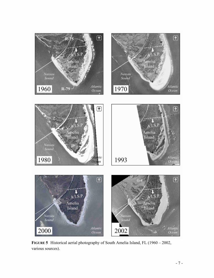
FIGURE 3 Historical bathymetries of Nassau Sound, FL. Both data sets indicate two predominant tidal channels through the sound. Contours represent seabed elevation in feet relative to the National Geodetic Vertical Datum, 1929. 1871 data from USCGS boat sheet, 1991 data surveyed by Bennett R. Wattles, Surveyors, Jacksonville, FL. Figure 4 depicts the locations of the thalwegs of the two dominant tidal channels over the course of the last 121 years. Over time, these channels have existed across a broad area, such that the migration area of each of the thalwegs is over one mile in width (Figure 4). At various points in time, the northern channel through the Sound has existed in an extreme northerly position, essentially attached to and wrapped around the South Amelia Island shoreline, connecting to the Atlantic Ocean through a previous marginal flood channel (as seen in the 1991 bathymetry of Figure 3). At these times, the southern end of Amelia Island experiences severe erosional stress. Such a condition emerged in the 1980’s and appeared to accelerate into the early 1990’s, causing a sharp increase in the erosion along South Amelia Island. Estimates of the erosion rate from 1974 to 1991 versus 1991 to 1994 indicate a 700% increase in the erosion rate. Although sufficient data do not exist to completely prove this theory, it is possible that a similar occurrence took place in the mid- to late-1950’s. Figure 5 presents aerial photography of the southern end of Amelia Island from 1960 to 2002. Although not presented herein, 1953 aerials indicate a broad vegetated area well seaward of the shoreline shown in the 1960 photograph. Further, historical shoreline position data indicate a 1957 shoreline substantially more eroded and comparable to the 1994 pre-beach fill condition (FDEP database).

- 6 -
FIGURE 4 Historical location of the thalwegs of the two predominant tidal channels through Nassau Sound, FL. Given these data and the extreme southerly location of the northern tidal channel through the Sound in 1954, it is hypothesized that the erosive condition indicated by the 1960 aerial was the result of a large shift in the location of the northern tidal channel, believed to be northward to a location adjacent to the tip of the island. Inspection of the aerials indicates the strong similarity in shoreline orientation between the eroded 1960 and 2000 conditions. More recently, the series of aerials in Figure 5 indicate the appearance and growth of a large spit seaward of R-77 to R-79 between 1960 and 1970. This spit subsequently became naturally vegetated over the 1970’s, but its shoreline also began to erode in the late 1970’s. As the spit eroded and the shoreline orientation changed, the erosion accelerated, consistent with the behavior shown in the measured beach profile data. This behavior led to the initiation of large scale beach restoration efforts along the southern end of Amelia Island in the 1990’s.
- 7 -
FIGURE 5 Historical aerial photography of South Amelia Island, FL (1960 – 2002, various sources).
- 8 -
Concurrent with the channel movement within the Sound and the corresponding shoreline changes along Little Talbot and Amelia Islands, the shoals that comprise the Bird Island Shoal Complex have likewise experienced significant changes over recent history. Figure 6 plots the location of the shoals within Nassau Sound since 1943, five years before the original A1A bridge over the Sound was constructed. Inspection of Figure 6 suggests a pattern of southerly shoal migration, followed by the onshore welding of segments of the shoal after the shifting of the southern tidal channel through the sound. In particular, Figure 6 depicts the large southern shoal that existed at the time of the 1991 survey. This shoal subsequently welded onto the north shoreline of Little Talbot Island, as indicated in the 2000 photo base of the figure. Subsequent to welding, another shoal begins to form in the middle of the Sound to repeat the process, such that throughout the time series, there are frequently two or more segments of the shoal complex. ENGINEERING ACTIVITY Nassau Sound is an unstabilized inlet, and no dredging of the Sound itself occurs for purposes of navigation. At present the new A1A bridge (completed in the late 1990’s) and the old A1A bridge (1948) over the sound represent the only permanent coastal structures in the area. Engineering responses to erosion along the South Amelia Island shoreline began in 1964 after Hurricane Dora with the construction of a granite revetment along American Beach, approximately 3.8 miles north of the tip of Amelia Island. In the 1970’s to mid-1980’s various truck haul and beach scraping operations were performed by private interests along Amelia Island Plantation (north of R-75, see Figure 5). From 1984 to 1991, private parties placed approximately 0.14 Mcy of sand for dune enhancement north of Amelia Island State Park (AISP). In 1993 the U.S. Army Corps of Engineers (USACE) constructed a beach disposal project at American Beach, placing 450,000 cy of sand along a one mile stretch approximately 3.5 miles north of the Sound. The following year, a private organization, the South Amelia Island Shoreline Stabilization Association, funded the construction of a 2.6 Mcy beach fill extending from south of American Beach to the northern boundary with the AISP. This project was immediately followed by the construction of four prototype geotextile groins, placed on either side of the AISP boundary. The geotextile groins, ultimately removed in 2002, were constructed to extend the life of the beach fill project. In 1997 and 2001, the USACE placed 300,000 cy of sand (600,000 cy total) along the AISP shoreline using beach disposal material from the Intracoastal Waterway. The 2002 beach renourishment project was extended southward to include the Atlantic Ocean shoreline of the AISP. This most recent project involved the placement of 1.8 Mcy. The post-construction beach fill condition can be seen in the 2002 aerial depicted in Figure 5.

- 9 -
FIG
UR
E 6
His
toric
al lo
catio
ns o
f the
eph
emer
al B
ird Is
land
Sho
al C
ompl
ex in
Nas
sau
Soun
d (O
lsen
Ass
ocia
tes,
2000
).
Phot
o da
te: 2
000

- 10 -
Including the 2002 renourishment project, over 5.6 Mcy of sand has been placed along the Atlantic Ocean shoreline of South Amelia Island since the 1980’s. The estimated erosional load is roughly 267,000 cy/yr along the southern 3.8 miles of the island. To combat the ongoing erosion, a second phase to the 2002 renourishment project is proposed. This phase includes a structural field, proposed to include a porous terminal structure at the southern terminus of the island, with an accompanying detached breakwater approximately 3,000 ft northward thereof along the Atlantic Ocean shoreline. The terminal structure is intended to stabilize the Atlantic Ocean and Nassau Sound shorelines, to protect the 2002 beach fill and minimize losses there from, and to separate a marginal flood channel from the interior of the Sound, thus preventing a future breakthrough of any major tidal channel in that location. INLET BEHAVIOR Inspection of all the available aerial photography and survey data lead to the following hypothesis for the morphodynamic behavior of the shoals within Nassau Sound and the adjacent shorelines (Olsen Associates, 2000). In specific regard to South Amelia Island, the accretion/erosion pattern of the sandy spit and the locations of the tidal channels and shoals in Nassau Sound suggests that the ebb-tidal delta experiences occasional breaching (e.g. Fitzgerald et al., 1978), such that the dominant tidal channels through the Sound shift northward to a more hydraulically efficient position, connecting to the ocean via existing marginal flood channels or other breaks or depressions the shoals (Figure 7). Consistent with the theories described above, the shoals that remain downdrift of the relocated channels then migrate toward the downdrift shoreline, eventually welding onto Little Talbot Island and contributing to the seaward downdrift offset of the inlet. This is the phenomenon outlined in the discussion of Figures 4 and 5, as well as Figure 7. An interesting result of the inlet behavior thought to occur at Nassau Sound is that ultimately the tendency exists for the inlet to migrate northward, against the direction of predominant littoral drift, and against the direction of shoal/channel migration, as the shoals weld onto Little Talbot Island (e.g. Aubrey and Speer, 1984). Additionally, inspection of the most recent bathymetric data indicate that while the southern tidal channel through the Sound remains a distinct feature running through the entire shoal system, the northern channel appears to dissipate within the shoals. This behavior is believed to be related to the migratory tendency of the Sound and may continue with the ongoing efforts to stabilize the south end of Amelia Island.

- 11 -
FIGURE 7 Hypothesized inlet shoal migration and breaching behavior (Olsen Associates, Inc., 2000). Adding to the littoral pressure for northward migration is the regional climate in which Nassau Sound lies (see Figure 1). The jetties at the St. Mary’s River Entrance have resulted in a chronic deficit of sand, principally to Amelia Island but also to Little Talbot Island. The jetties at St. Johns River Entrance, however, provide a stabilizing influence on this littoral cell, trapping sand against the north jetty at Wards Bank and placing pressure on Ft. George Inlet to migrate northward, leading to severe erosion of the south end of Little Talbot Island. This phenomenon strongly resembles the behavior at Nassau Sound immediately to the north.

- 12 -
CONCLUSIONS Historical analysis of Nassau Sound and its adjacent shorelines along south Amelia Island and Little Talbot Island reveals a pattern of ebb shoal breaching and shifting of the tidal channels through the Sound. This pattern is hypothesized to be strongly related to the cycles of erosion measured along the southern Atlantic Ocean shoreline of Amelia Island, and the accretion of the Sound shoreline of Little Talbot Island. As the channels shift northward, increased pressure is applied to south Amelia Island and the shoals in the Sound that remain south of the new channel locations continue to migrate southward, eventually welding onto Little Talbot Island. Further prompting this phenomenon are the interruption of littoral supply caused by the St. Mary’s River Entrance jetties and the stabilizing influence of the north jetty at the St. Johns River Entrance. In addition to the overall decrease in the sediment supply, another effect of these jettied entrances is the “backing up” of the tidal entrances in this littoral cell as they attempt to migrate north against the direction of net littoral drift. These changes have placed increasing erosional pressure on the southern end of Amelia Island, prompting coastal engineering action to protect valuable resources along State Park and privately held lands. Since the mid-1980’s, approximately 5.6 million cubic yards of sand has been placed along the southern 3.8 miles of the island to attempt to keep pace with the annual erosion there along, estimated to be approximately 267,000 cy/yr. The ongoing battle against this recession has prompted the design of a structural field for the south end of the island which proposes the construction of a porous terminal structure and detached breakwater. These improvements are intended to protect the State Park and to reduce losses from the shoreline northward thereof, thus extending the maintenance cycle of renourishment. REFERENCES Aubrey, D.G., and Speer, P.E. (1984). “Updrift Migration of Tidal Inlets.” Journal of Geology, 192,
University of Chicago Press, Chicago, IL, pp 531-546. Byrnes, M.R., and Hiland, M.W. (1995). “Large-scale sediment transport patterns of the continental shelf
and influence on shoreline response: St. Andrew Sound, Georgia to Nassau Sound, Florida, USA.” Marine Geology, 126, Elsevier Science, B.V., Amsterdam, The Netherlands, pp 19-43.
FitzGerald, D.M., Hubbard, D.K., and Nummedal, D. (1978). “Shoreline changes associated with tidal
inlets along the South Carolina coast.” Proceedings of Coastal Zone ’78, American Society of Civil Engineers, New York, NY, pp1973-1974.

- 13 -
Olsen Associates, Inc. (2000). “South Amelia Island Shoreline Stabilization Project, Feasibility Study,” Report submitted to Nassau County Board of County Commissioners, Nassau County, FL. Olsen Associates, Inc., 4438 Herschel St., Jacksonville, FL., 32210.
Olsen Associates, Inc. (2003). “Amelia Island, Florida, Islandwide Beach Monitoring 2000-2001,” Report
submitted to Nassau County Board of County Commissioners, Nassau County, FL, and the Fernandina Beach City Commission. Olsen Associates, Inc., 4438 Herschel St., Jacksonville, FL., 32210.
Raichle, A.W., Olsen Associates, Inc. (1993). “Nassau Sound Inlet Management Plan, DRAFT.” Report
submitted to Nassau County Soil and Water Conservation District (October 1993). Taylor Engineering (2002, DRAFT). “Diagnostic Modeling System Application: NE Florida, Regional
Sediment Management, Evaluation of Regional Sediment Management Potential, Demonstration Project: South Amelia Island Stabilization.” Report submitted to USACE Jacksonville District, and FDEP Bureau of Beaches and Wetlands Resources, report prepared by Taylor Engineering, Inc., Jacksonville, FL. September 2002.