Embed Size (px)
Citation preview

http://space-geodesy.nasa.gov 2/4/2013 0
NASA SLR Operations Scheduling Process
Dave McCormick October 2016 ILRS 20th Workshop Potsdam, Germany
http://space-geodesy.nasa.gov 2/4/2013 1
NASA Network Scheduling and Alternatives
Review of network characteristics and constraints Current tracking statistics Alternatives for improvement in:
– data yield for missions – scientific benefit (Where budgets prohibit obvious (KHz) system upgrades or crew/labor increase)

http://space-geodesy.nasa.gov 2/4/2013 2
NASA SLR Operations
NASA NETWORK COMPONENTS: Station Operations TLRS, MOBLAS, MLRS Network Sustainment Spares, Engineering, Logistics Data Operations Center Data quality checks and prediction/scheduling center
.
International Laser Ranging Service Central Bureau Coordinating Network activities and developing
priorities and strategies Analysis Center Ensuring standard procedures and coordinating the
data product
M5 M6 M8
M7 M4
T4
T3
MLRS
NASA International Partner
NASA contractor

http://space-geodesy.nasa.gov 2/4/2013 3
ILRS/NASA Yearly Data Yield September 20, 2016 Update Graph by Carey Noll
0
5
10
15
20
25
30
35
40
0
20,000
40,000
60,000
80,000
100,000
120,000
140,000
160,000
180,000
1996 1997 1998 1999 2000 2001 2002 2003 2004 2005 2006 2007 2008 2009 2010 2011 2012 2013 2014 2015 2016
No.
Sta
tions
No.
of P
ass S
egm
ents
Year
No. NASA Pass Segments No. Other Pass Segments No. NASA Stations No. Other Stations

http://space-geodesy.nasa.gov 2/4/2013 4
ILRS Yearly Data Yield September 20, 2016 Update Graph by Carey Noll
0
10
20
30
40
50
60
70
0
20,000
40,000
60,000
80,000
100,000
120,000
140,000
160,000
180,000
2000 2001 2002 2003 2004 2005 2006 2007 2008 2009 2010 2011 2012 2013 2014 2015 2016
Num
ber o
f Sat
ellit
es/S
tatio
ns
Num
ber o
f Pas
ses
Year
Low Satellites LAGEOS High Satellites No. Stations No. Low Satellites No. High Satellites
http://space-geodesy.nasa.gov 2/4/2013 5
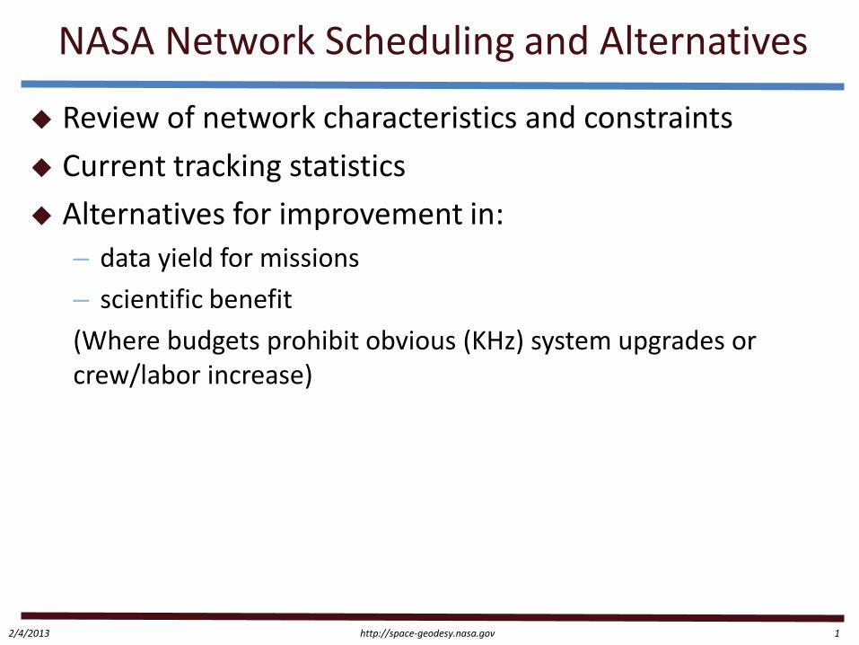
NASA Network Stations Resources
Australia (MOBLAS 5) 24 hr x 7 days South Africa (MOBLAS 6) 24 hr x 5 days + 16 hr x 2 days (weekend)
Peru (TLRS3) 24 hr x 5 days + some weekend shifts, No HEO
Maryland (MOBLAS 7) 24 hr x 5 days Hawaii (TLRS4) 8 hr x 6 days, 16 hr x 1 day, No HEO California (MOBLAS 4) – 16 hr x 5 days Tahiti (MOBLAS 8) – 20 hrs x 4 days MLRS – 10 hrs x 4 days
http://space-geodesy.nasa.gov 2/4/2013 6
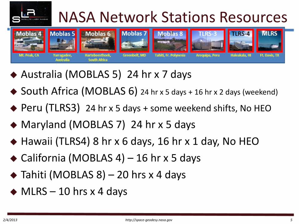
51.0%
75.7%
29.3%
42.9%
21.3% 24.7%
49.5%
20.2%
52.1%
40.5%
19.8%
38.3%
52.8%
77.1%
46.7%
28.5%
70.9%
37.4%
4.0% 0.4%
7.7%
2.6% 0.9% 1.8% 0.5% 1.5% 2.2%
4.5% 4.1%
24.7%
1.6% 0.7%
26.8%
21.5%
7.3% 8.4%
0.0%
10.0%
20.0%
30.0%
40.0%
50.0%
60.0%
70.0%
80.0%
90.0%
M4 M5 M6 M7 M8 T3 T4 MLRS Network Total
NASA SLR Tracking Statistics June 2015- May 2016
Tracking % Weather Down % System Down % Misc. %
Laser report data manually entered with some weeks omitted (not exact)

http://space-geodesy.nasa.gov 2/4/2013 7
NASA Constraints
External ground calibration 2 hour maximum interval and takes 10 minutes (no internal cal except MLRS)
Divergence is not adjustable (except MLRS) Target acquisition:
– LEO: initial acquisition can be high as 30 sec-1min – LAGEOS > 30 degrees generally – HEO - improvement when returning to a satellite from
interleave by knowing prior bias

http://space-geodesy.nasa.gov 2/4/2013 8
NASA Constraints
Laser Rep Rate – (will increase to 10 Hz for all satellites
with full event timer implementation)
– HEO – 2 Hz – LAGEOS – 4/5 Hz – LEO – 10Hz
ILRS NP bin size – HEO/GNSS – 5 minutes – LAGEOS – 2 minutes – LARES – 30 seconds – LEO – 5 to 30 seconds
NASA Station Horizon – GODL – 10 degrees
• with VLBI quadrant mask to 20 degrees
– YARL – 15 degrees – All others – 20 degrees
Operation Mode – Few Photon

http://space-geodesy.nasa.gov 2/4/2013 9
NASA Schedule
Schedule based on ILRS priority/altitude A schedule is made for each station weekly at the
Operations Center and distributed – Used only as part of a template for station reports to be
returned to Engineering each week
Actual tracking schedule is simply the chronological sequence of satellite availability and ILRS priority – All passes remain available – Some stations/managers facilitate/adjust station schedules to
maximize data and adjust crew shifts for optimal times • Predetermined calibration periods • Special reminders included
http://space-geodesy.nasa.gov 2/4/2013 10
Schedule Implementation
Operators go by priority list but exercise real-time flexibility based on local conditions and their experience of success based on the constraints for interleaving or satellite alternatives – Focus on low noise data – Approximately 25 operators
Weather awareness and experience – influences decisions and pursuit of options/opportunities
Many LEO passes do not present good interleaving opportunities
http://space-geodesy.nasa.gov 2/4/2013 11
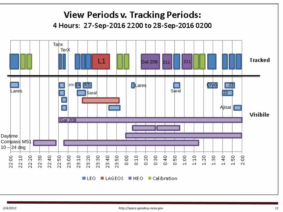
L1
K5
Saral
HY-2A
Gal 208
Saral
211 211
Cryo J2
J3
Ajisai
Tanx TerX
Lares
Daytime Compass MS1 10 – 24 deg
Gal 208
Lares
http://space-geodesy.nasa.gov 2/4/2013 12
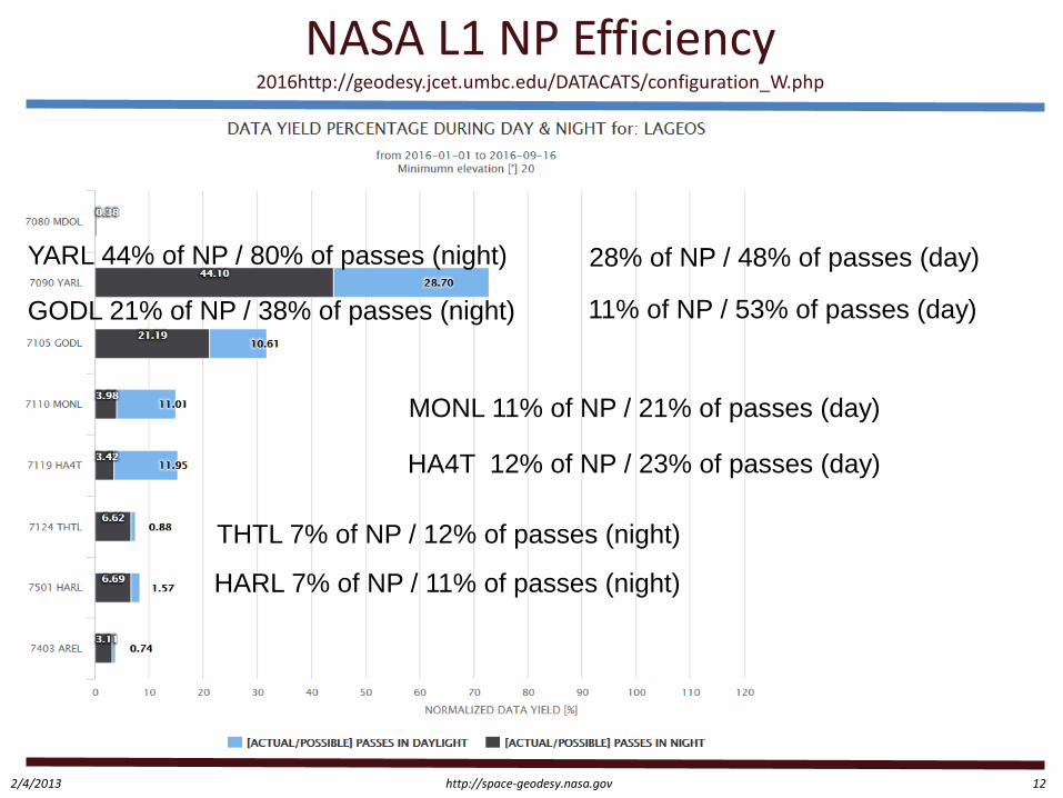
NASA L1 NP Efficiency 2016http://geodesy.jcet.umbc.edu/DATACATS/configuration_W.php
YARL 44% of NP / 80% of passes (night) 28% of NP / 48% of passes (day)
GODL 21% of NP / 38% of passes (night) 11% of NP / 53% of passes (day)
HARL 7% of NP / 11% of passes (night)
THTL 7% of NP / 12% of passes (night)
HA4T 12% of NP / 23% of passes (day)
MONL 11% of NP / 21% of passes (day)

http://space-geodesy.nasa.gov 2/4/2013 13
NASA L2 Efficiency
http://space-geodesy.nasa.gov 2/4/2013 14

http://space-geodesy.nasa.gov 2/4/2013 15
Mission Tracking Needs QZS-1 Accuracy evaluation using SLR data has helped modeling and parameter tuning for QZS-1 Orbit Determination.
Ref: Matera Role of SLR on QZSS operation Yoshimi Ohshima, Ph.D. NEC Corporation [email protected]

http://space-geodesy.nasa.gov 2/4/2013 16
Scheduling Alternatives/Improvement
Goal of a stable terrestrial reference frame – Accuracy: ≤ 1 mm (1-Sigma) in X, Y, Z (decadal scale) – Stability: ≤ 0.1mm/yr (annual scale) – Does this allow any relaxation of ILRS quality requirements or
bin size as a way to achieve more yield? – How is this translated into station metrics or resource
planning?
http://space-geodesy.nasa.gov 2/4/2013 17
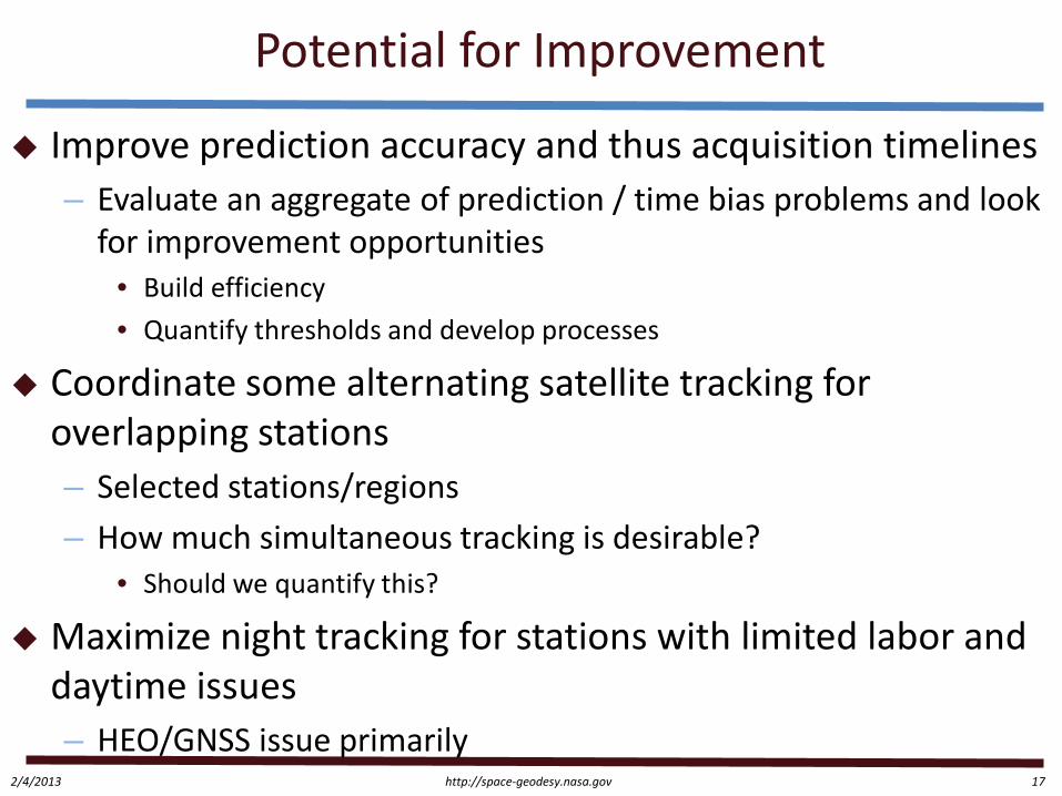
Potential for Improvement
Improve prediction accuracy and thus acquisition timelines – Evaluate an aggregate of prediction / time bias problems and look
for improvement opportunities • Build efficiency • Quantify thresholds and develop processes
Coordinate some alternating satellite tracking for overlapping stations – Selected stations/regions – How much simultaneous tracking is desirable?
• Should we quantify this?
Maximize night tracking for stations with limited labor and daytime issues – HEO/GNSS issue primarily
http://space-geodesy.nasa.gov 2/4/2013 18
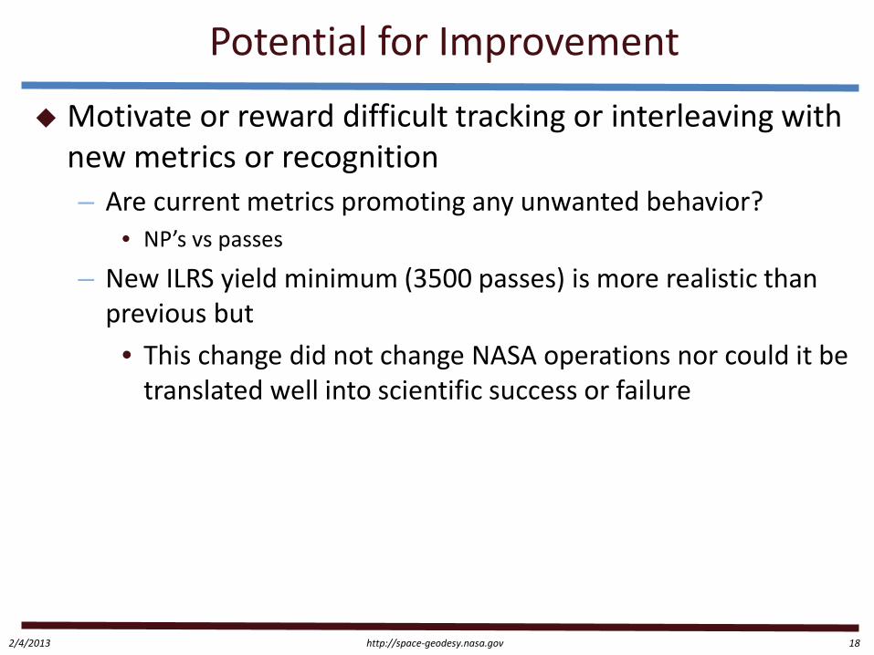
Potential for Improvement
Motivate or reward difficult tracking or interleaving with new metrics or recognition – Are current metrics promoting any unwanted behavior?
• NP’s vs passes
– New ILRS yield minimum (3500 passes) is more realistic than previous but
• This change did not change NASA operations nor could it be translated well into scientific success or failure

http://space-geodesy.nasa.gov 2/4/2013 19
Potential for Improvement
Quantify every mission/user’s minimum data/tracking threshold and develop the process of mission/user feedback to the ILRS – Translate into clear goals and mission tracking intervals that
station operators can understand and implement • # NP/pass, etc.
– Metrics relatable to our sponsors – Prepares ILRS for additional satellites/requirements – Future:
• Web-tool display of real time priority change • Continued refinement
Example: requirement / actual
http://space-geodesy.nasa.gov 2/4/2013 20
Back up slides

http://space-geodesy.nasa.gov 2/4/2013 21
Mission Tracking Needs
In Matera we received some mission feedback Galileo
– SLR measurements are of great benefit for: • Galileo orbit validation • Galileo force model development and validation
– Points for improvement: • “It would be very much appreciated if the position of the Galileo
satellites in the ILRS mission priority list could be increased”
year 2015 NPT/Day % days
tracked GAL 101-104 16 96 GAL 201-204 9 82
Ref: Matera: SLR measurements and their importance for Galileo Werner Enderle, Daniel Navarro-Reyes, Francisco Gonzalez, Erik Schoenemann, René Zandbergen 26/10/2015

http://space-geodesy.nasa.gov 2/4/2013 22
Mission Tracking Needs
To achieve the centimeter accuracy of orbits determination for navigation SC equipped
with laser retro-reflectors, the performance rates of SLR station must be increased by more than 1 order at the expense of a data collection time reduction and automatic functioning under day conditions and through overcast breaks. In fact ,we mean making SLR stations function in a 24/7 mode of operation.
Ref Matera: M. A. Sadovnikov, V.D. Shargorodskiy RESEARCH-AND-PRODUCTION CORPORATION
«PRECISION SYSTEMS AND INSTRUMENTS»Moscow, Russia
http://space-geodesy.nasa.gov 2/4/2013 23
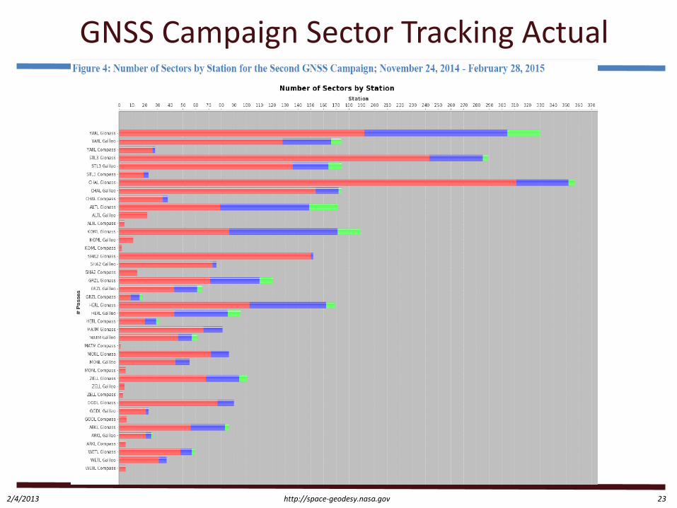
GNSS Campaign Sector Tracking Actual
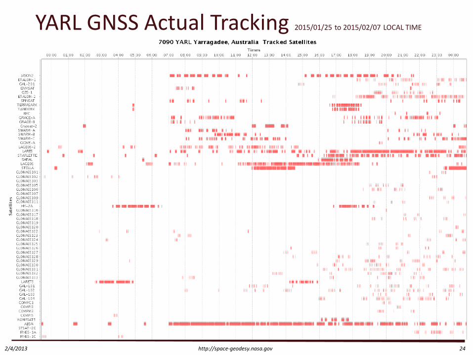
http://space-geodesy.nasa.gov 2/4/2013 24
YARL GNSS Actual Tracking 2015/01/25 to 2015/02/07 LOCAL TIME
http://space-geodesy.nasa.gov 2/4/2013 25
ILRS Data Constraints
Nice France 2002 meeting; minimum data requirement – Daytime normal points - minimum 6 data points – Night time normal points - minimum 3 data points – Fewer data points would be acceptable on lower satellites (5-
second normal points) from those ranging systems with lower pulse repetition rates where these minimum requirements are not practical.
Bad Koetzting Germany 2003; stations may exercise their own discretion on setting minimum data criteria per normal point. Nice criteria recommended by ILRS GB for single photoelectron systems with high data yield. Stations with KHz rates may select more stringent criteria (specify in site logs!)