Embed Size (px)
Citation preview
Preliminary Performance Analysis for the Korean SLR
station “DAEDEOK-73592601”
Korea Astronomy and Space Science Institute (KASI) has developed two SLR systems. One of them was
constructed and registered with ILRS SLR tracking station DAEDEOK(DAEK, 73592601). From August 2013, DAEK
has been providing SLR Normal Point (NP) data to the ILRS Data Center. Through the ILRS evaluation and validation
process, DAEK station became an active station in April 2014. KASI SLR team has performed SLR data process for
LAGEOS-1/2 precise orbit determination (POD) and DAEK station performance analysis for normal operation. In this
paper, the preliminarily performance analysis for the DAEK station using LAGEOS-1/2 NP data is presented in terms of
the POD RMS and station bias stability results.
Abstract
LAGEOS-1 Geodetic Satellite
Precise Orbit Determination of LAGEOS
Precise Orbit Determination Results (Continued)
Summary and Future Work
Summary
Pass-by-Pass Orbit Estimation for LAGEOS-1,-2 and Range Bias Analysis for ILRS stations
KASI SLR data processing – 14 ILRS stations including Daedeok(Korean SLR System) NP data
Preliminarily performance analysis for the Daedeok and ILRS stations using LAGEOS-1/2 NP data
is presented in terms of the POD RMS and shot term range bias stability results.
Future Wok
Long term SLR data processing
Considering more geodetic satellites/ILRS stations NP data
Global SLR Station Quality Assessment
Precise Orbit Determination(POD) System Configuration & Strategy
Dynamic, measurement models/parameters, and reference frame for POD
Measurement data : NP data from 14 ILRS stations
McDonald(7080), Yarragadee(7090), Greenbelt(7105), Monument Peak(7110), Daedeok(7359),
Zimmerwald@532(7810), Mount Stromlo(7825), Simosato(7838), Graz(7839), Herstmonceux(7840),
Potsdam(7841), Matera(7845), Grasse(7941), Wettzell(8834)
All stations are same weight for pass-by-pass estimation
Precise Orbit Determination Results
POD Results of LAGEOS
Post-fit residual for LAGEOS, Pass-by-Pass Estimation
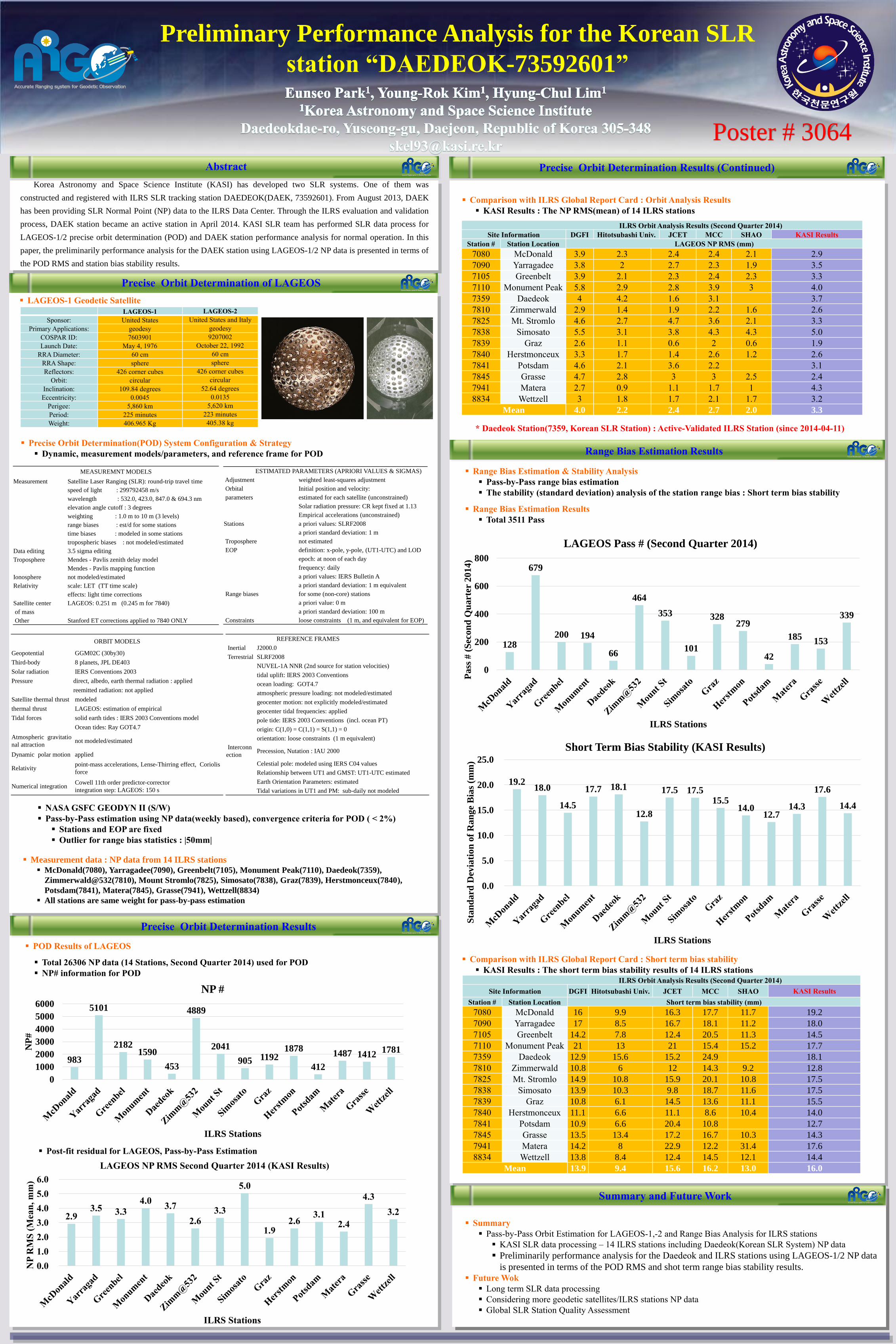
Range Bias Estimation Results
Range Bias Estimation & Stability Analysis
Pass-by-Pass range bias estimation
The stability (standard deviation) analysis of the station range bias : Short term bias stability
Range Bias Estimation Results
Total 3511 Pass
NASA GSFC GEODYN II (S/W)
Pass-by-Pass estimation using NP data(weekly based), convergence criteria for POD ( < 2%)
Stations and EOP are fixed
Outlier for range bias statistics : |50mm|
ILRS Orbit Analysis Results (Second Quarter 2014)
Site Information DGFI Hitotsubashi Univ. JCET MCC SHAO KASI Results
Station # Station Location LAGEOS NP RMS (mm)
7080 McDonald 3.9 2.3 2.4 2.4 2.1 2.9
7090 Yarragadee 3.8 2 2.7 2.3 1.9 3.5
7105 Greenbelt 3.9 2.1 2.3 2.4 2.3 3.3
7110 Monument Peak 5.8 2.9 2.8 3.9 3 4.0
7359 Daedeok 4 4.2 1.6 3.1 3.7
7810 Zimmerwald 2.9 1.4 1.9 2.2 1.6 2.6
7825 Mt. Stromlo 4.6 2.7 4.7 3.6 2.1 3.3
7838 Simosato 5.5 3.1 3.8 4.3 4.3 5.0
7839 Graz 2.6 1.1 0.6 2 0.6 1.9
7840 Herstmonceux 3.3 1.7 1.4 2.6 1.2 2.6
7841 Potsdam 4.6 2.1 3.6 2.2 3.1
7845 Grasse 4.7 2.8 3 3 2.5 2.4
7941 Matera 2.7 0.9 1.1 1.7 1 4.3
8834 Wettzell 3 1.8 1.7 2.1 1.7 3.2
Mean 4.0 2.2 2.4 2.7 2.0 3.3
Comparison with ILRS Global Report Card : Orbit Analysis Results
KASI Results : The NP RMS(mean) of 14 ILRS stations
* Daedeok Station(7359, Korean SLR Station) : Active-Validated ILRS Station (since 2014-04-11)
Total 26306 NP data (14 Stations, Second Quarter 2014) used for POD
NP# information for POD
Comparison with ILRS Global Report Card : Short term bias stability
KASI Results : The short term bias stability results of 14 ILRS stations
LAGEOS-1 LAGEOS-2
Sponsor: United States United States and Italy
Primary Applications: geodesy geodesy
COSPAR ID: 7603901 9207002
Launch Date: May 4, 1976 October 22, 1992
RRA Diameter: 60 cm 60 cm
RRA Shape: sphere sphere
Reflectors: 426 corner cubes 426 corner cubes
Orbit: circular circular
Inclination: 109.84 degrees 52.64 degrees
Eccentricity: 0.0045 0.0135
Perigee: 5,860 km 5,620 km
Period: 225 minutes 223 minutes
Weight: 406.965 Kg 405.38 kg
2.9 3.5 3.3
4.0 3.7
2.6 3.3
5.0
1.9 2.6
3.1 2.4
4.3
3.2
0.0
1.0
2.0
3.0
4.0
5.0
6.0
NP
RM
S (
Mean
, m
m)
ILRS Stations
LAGEOS NP RMS Second Quarter 2014 (KASI Results)
983
5101
21821590
453
4889
2041
905 11921878
412
1487 14121781
0
1000
2000
3000
4000
5000
6000
NP
#
ILRS Stations
NP #
128
679
200 194
66
464
353
101
328279
42
185153
339
0
200
400
600
800
Pass
# (
Sec
on
d Q
uart
er
2014)
ILRS Stations
LAGEOS Pass # (Second Quarter 2014)
ILRS Orbit Analysis Results (Second Quarter 2014)
Site Information DGFI Hitotsubashi Univ. JCET MCC SHAO KASI Results
Station # Station Location Short term bias stability (mm)
7080 McDonald 16 9.9 16.3 17.7 11.7 19.2
7090 Yarragadee 17 8.5 16.7 18.1 11.2 18.0
7105 Greenbelt 14.2 7.8 12.4 20.5 11.3 14.5
7110 Monument Peak 21 13 21 15.4 15.2 17.7
7359 Daedeok 12.9 15.6 15.2 24.9 18.1
7810 Zimmerwald 10.8 6 12 14.3 9.2 12.8
7825 Mt. Stromlo 14.9 10.8 15.9 20.1 10.8 17.5
7838 Simosato 13.9 10.3 9.8 18.7 11.6 17.5
7839 Graz 10.8 6.1 14.5 13.6 11.1 15.5
7840 Herstmonceux 11.1 6.6 11.1 8.6 10.4 14.0
7841 Potsdam 10.9 6.6 20.4 10.8 12.7
7845 Grasse 13.5 13.4 17.2 16.7 10.3 14.3
7941 Matera 14.2 8 22.9 12.2 31.4 17.6
8834 Wettzell 13.8 8.4 12.4 14.5 12.1 14.4
Mean 13.9 9.4 15.6 16.2 13.0 16.0
19.2 18.0
14.5
17.7 18.1
12.8
17.5 17.5 15.5
14.0 12.7
14.3
17.6
14.4
0.0
5.0
10.0
15.0
20.0
25.0
Sta
nd
ard
Dev
iati
on
of
Ran
ge
Bia
s (m
m)
ILRS Stations
Short Term Bias Stability (KASI Results)
MEASUREMNT MODELS
Measurement Satellite Laser Ranging (SLR): round-trip travel time
speed of light : 299792458 m/s
wavelength : 532.0, 423.0, 847.0 & 694.3 nm
elevation angle cutoff : 3 degrees
weighting : 1.0 m to 10 m (3 levels)
range biases : est/d for some stations
time biases : modeled in some stations
tropospheric biases : not modeled/estimated
Data editing 3.5 sigma editing
Troposphere Mendes - Pavlis zenith delay model
Mendes - Pavlis mapping function
Ionosphere not modeled/estimated
Relativity scale: LET (TT time scale)
effects: light time corrections
Satellite center LAGEOS: 0.251 m (0.245 m for 7840)
of mass
Other Stanford ET corrections applied to 7840 ONLY
ORBIT MODELS
Geopotential GGM02C (30by30)
Third-body 8 planets, JPL DE403
Solar radiation IERS Conventions 2003
Pressure direct, albedo, earth thermal radiation : applied
reemitted radiation: not applied
Satellite thermal thrust modeled
thermal thrust LAGEOS: estimation of empirical
Tidal forces solid earth tides : IERS 2003 Conventions model
Ocean tides: Ray GOT4.7
Atmospheric gravitatio
nal attractionnot modeled/estimated
Dynamic polar motion applied
Relativity point-mass accelerations, Lense-Thirring effect, Coriolis
force
Numerical integration Cowell 11th order predictor-corrector
integration step: LAGEOS: 150 s
ESTIMATED PARAMETERS (APRIORI VALUES & SIGMAS)
Adjustment weighted least-squares adjustment
Orbital Initial position and velocity:
parameters estimated for each satellite (unconstrained)
Solar radiation pressure: CR kept fixed at 1.13
Empirical accelerations (unconstrained)
Stations a priori values: SLRF2008
a priori standard deviation: 1 m
Troposphere not estimated
EOP definition: x-pole, y-pole, (UT1-UTC) and LOD
epoch: at noon of each day
frequency: daily
a priori values: IERS Bulletin A
a priori standard deviation: 1 m equivalent
Range biases for some (non-core) stations
a priori value: 0 m
a priori standard deviation: 100 m
Constraints loose constraints (1 m, and equivalent for EOP)
REFERENCE FRAMES
Inertial J2000.0
Terrestrial SLRF2008
NUVEL-1A NNR (2nd source for station velocities)
tidal uplift: IERS 2003 Conventions
ocean loading: GOT4.7
atmospheric pressure loading: not modeled/estimated
geocenter motion: not explicitly modeled/estimated
geocenter tidal frequencies: applied
pole tide: IERS 2003 Conventions (incl. ocean PT)
origin: C(1,0) = C(1,1) = S(1,1) = 0
orientation: loose constraints (1 m equivalent)
Interconn
ection Precession, Nutation : IAU 2000
Celestial pole: modeled using IERS C04 values
Relationship between UT1 and GMST: UT1-UTC estimated
Earth Orientation Parameters: estimated
Tidal variations in UT1 and PM: sub-daily not modeled
Poster # 3064