Embed Size (px)
Citation preview
NASA LIS-based NLDAS status and future plans
Christa Peters-Lidard, Sujay Kumar, David Mocko, Shugong Wang, Yuqiong Liu, James Geiger, Kristi Arsenault, Grey Nearing
NASA/GSFC Hydrological Sciences Laboratory
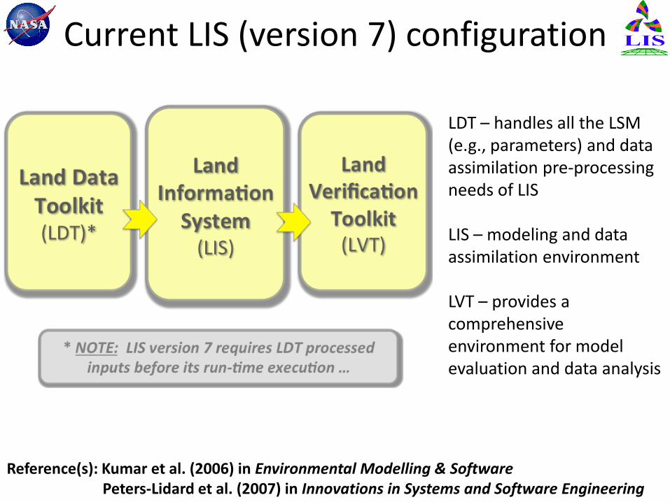
Current LIS (version 7) configuration
LDT – handles all the LSM (e.g., parameters) and data assimilation pre-processing needs of LIS LIS – modeling and data assimilation environment LVT – provides a comprehensive environment for model evaluation and data analysis
Reference(s): Kumar et al. (2006) in Environmental Modelling & Software Peters-Lidard et al. (2007) in Innovations in Systems and Software Engineering
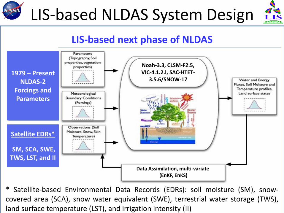
LIS-based NLDAS System Design
Satellite EDRs*
SM, SCA, SWE, TWS, LST, and II
Noah-3.3, CLSM-F2.5, VIC-4.1.2.l, SAC-HTET-
3.5.6/SNOW-17
LIS-based next phase of NLDAS
* Satellite-based Environmental Data Records (EDRs): soil moisture (SM), snow-covered area (SCA), snow water equivalent (SWE), terrestrial water storage (TWS), land surface temperature (LST), and irrigation intensity (II)
1979 – Present NLDAS-2
Forcings and Parameters
Data Assimilation, multi-variate (EnKF, EnKS)
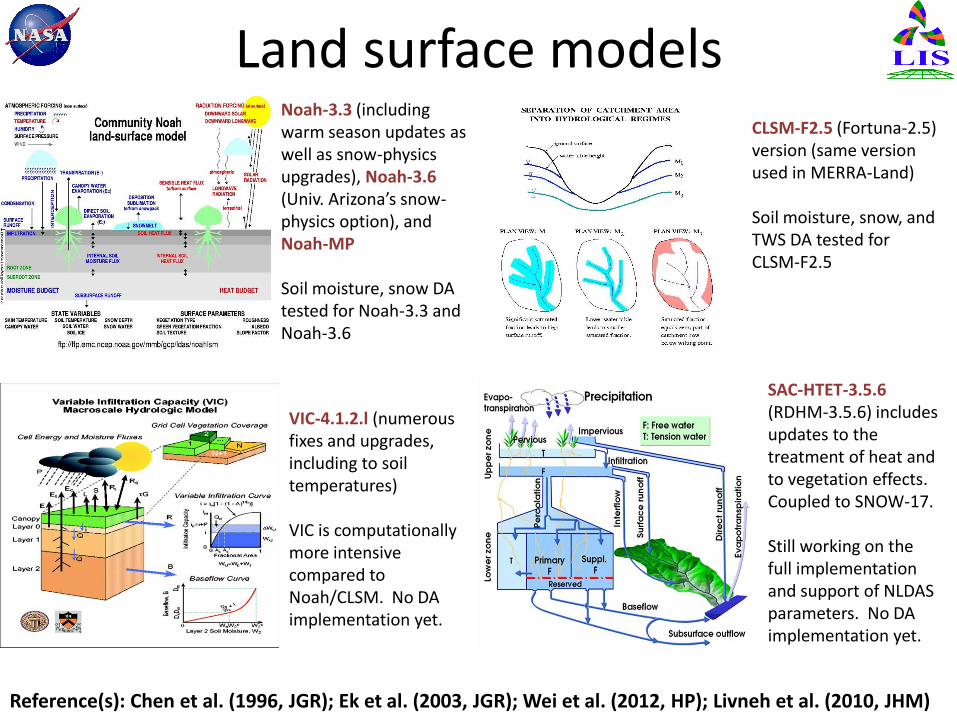
Land surface models
Reference(s): Chen et al. (1996, JGR); Ek et al. (2003, JGR); Wei et al. (2012, HP); Livneh et al. (2010, JHM)
Noah-3.3 (including warm season updates as well as snow-physics upgrades), Noah-3.6 (Univ. Arizona’s snow-physics option), and Noah-MP Soil moisture, snow DA tested for Noah-3.3 and Noah-3.6
CLSM-F2.5 (Fortuna-2.5) version (same version used in MERRA-Land) Soil moisture, snow, and TWS DA tested for CLSM-F2.5
VIC-4.1.2.l (numerous fixes and upgrades, including to soil temperatures) VIC is computationally more intensive compared to Noah/CLSM. No DA implementation yet.
SAC-HTET-3.5.6 (RDHM-3.5.6) includes updates to the treatment of heat and to vegetation effects. Coupled to SNOW-17. Still working on the full implementation and support of NLDAS parameters. No DA implementation yet.
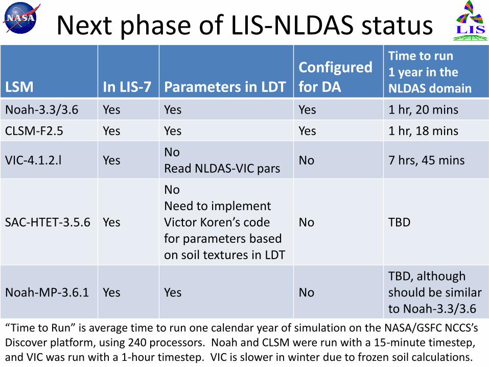
Next phase of LIS-NLDAS status
LSM In LIS-7 Parameters in LDT Configured for DA
Time to run 1 year in the NLDAS domain
Noah-3.3/3.6 Yes Yes Yes 1 hr, 20 mins
CLSM-F2.5 Yes Yes Yes 1 hr, 18 mins
VIC-4.1.2.l Yes No Read NLDAS-VIC pars
No 7 hrs, 45 mins
SAC-HTET-3.5.6 Yes
No Need to implement Victor Koren’s code for parameters based on soil textures in LDT
No TBD
Noah-MP-3.6.1 Yes Yes No TBD, although should be similar to Noah-3.3/3.6
“Time to Run” is average time to run one calendar year of simulation on the NASA/GSFC NCCS’s Discover platform, using 240 processors. Noah and CLSM were run with a 15-minute timestep, and VIC was run with a 1-hour timestep. VIC is slower in winter due to frozen soil calculations.
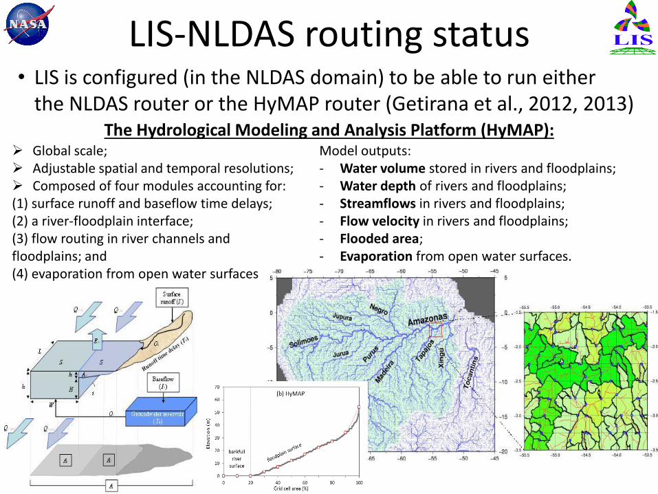
LIS-NLDAS routing status • LIS is configured (in the NLDAS domain) to be able to run either
the NLDAS router or the HyMAP router (Getirana et al., 2012, 2013)
Global scale; Adjustable spatial and temporal resolutions; Composed of four modules accounting for: (1) surface runoff and baseflow time delays; (2) a river-floodplain interface; (3) flow routing in river channels and floodplains; and (4) evaporation from open water surfaces
Model outputs: - Water volume stored in rivers and floodplains; - Water depth of rivers and floodplains; - Streamflows in rivers and floodplains; - Flow velocity in rivers and floodplains; - Flooded area; - Evaporation from open water surfaces.
The Hydrological Modeling and Analysis Platform (HyMAP):
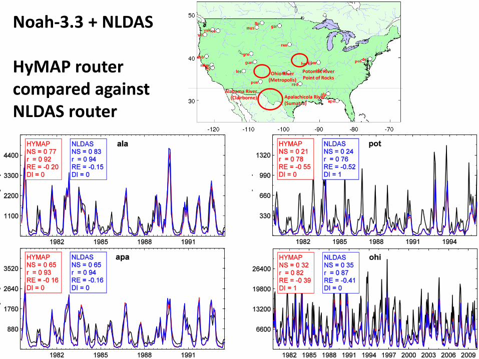
Alabama River (Clairborne)
Potomac River Point of Rocks
Ohio River (Metropolis)
Apalachicola River (Sumatra)
Noah-3.3 + NLDAS HyMAP router compared against NLDAS router
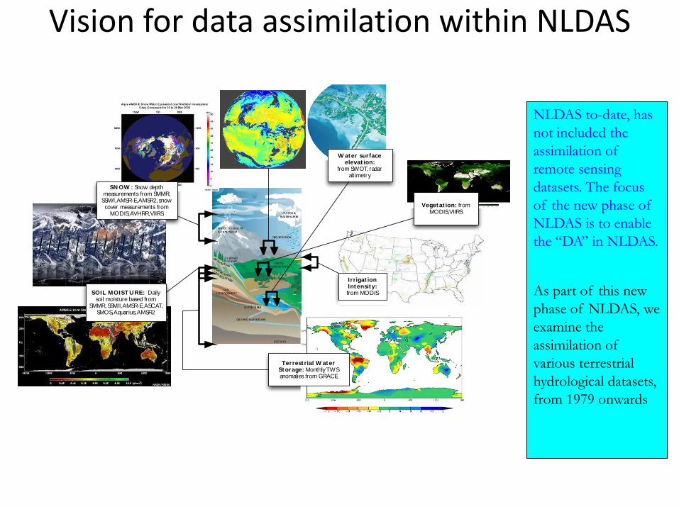
NLDAS to-date, has
not included the
assimilation of
remote sensing
datasets. The focus
of the new phase of
NLDAS is to enable
the “DA” in NLDAS.
As part of this new
phase of NLDAS, we
examine the
assimilation of
various terrestrial
hydrological datasets,
from 1979 onwards
SOIL MOIST U RE: Daily soil moisture based from
SMMR, SSM/I, AMSR-E, ASCAT, SMOS, Aquarius, AMSR2
Terrest rial W at er St orage: Monthly TWS anomalies from GRACE
Irrigat ion Int ensity:from MODIS
SN OW : Snow depth measurements from SMMR,
SSM/I, AMSR-E, AMSR2, snow cover measurements from
MODIS, AVHRR, VIIRS
W ater surface elevat ion:
from SWOT, radar altimetry
Veget at ion: from MODIS, VIIRS
Vision for data assimilation within NLDAS
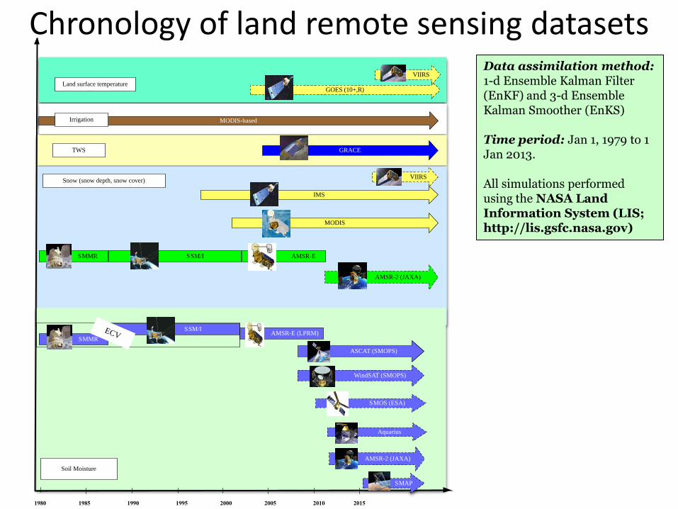
Chronology of land remote sensing datasets
Data assimilation method: 1-d Ensemble Kalman Filter (EnKF) and 3-d Ensemble Kalman Smoother (EnKS) Time period: Jan 1, 1979 to 1 Jan 2013. All simulations performed using the NASA Land Information System (LIS; http://lis.gsfc.nasa.gov)
1980 1985 1990 1995 2000 2005 2010 2015
AMSR-E (LPRM)
ASCAT (SMOPS)
SMMR SSM/I
MODIS
IMS
GRACE
AMSR-E
MODIS-based
Soil Moisture
Snow (snow depth, snow cover)
TWS
Irrigation
SMMR
SSM/IECV
SMOS (ESA)
Aquarius
SMAP
WindSAT (SMOPS)
VIIRS
AMSR-2 (JAXA)
AMSR-2 (JAXA)
GOES (10+,R)Land surface temperature
VIIRS
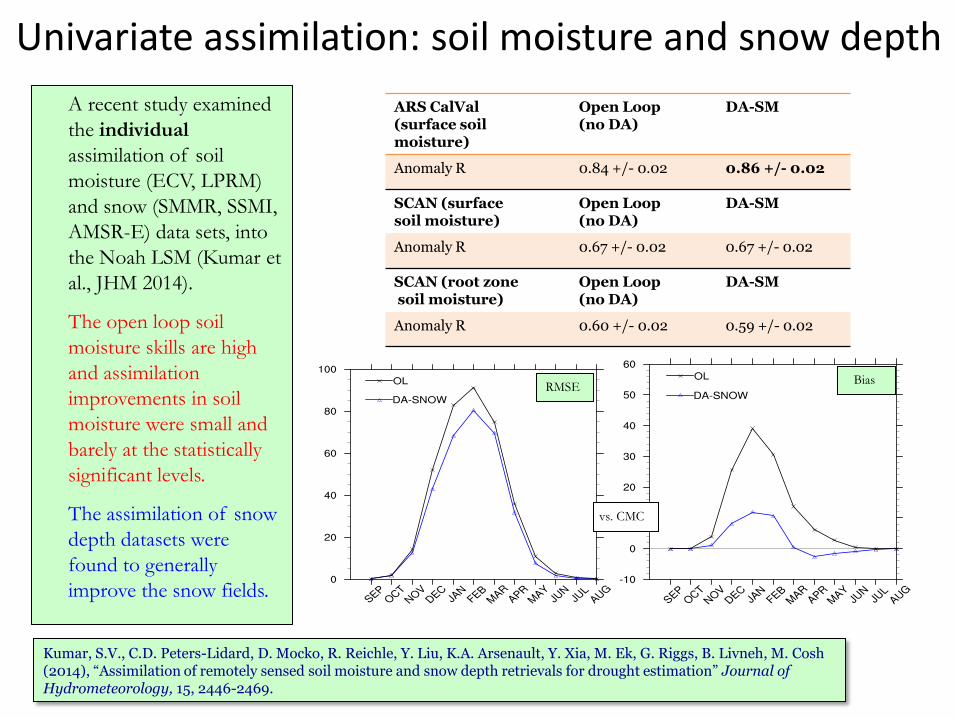
Univariate assimilation: soil moisture and snow depth
Kumar, S.V., C.D. Peters-Lidard, D. Mocko, R. Reichle, Y. Liu, K.A. Arsenault, Y. Xia, M. Ek, G. Riggs, B. Livneh, M. Cosh (2014), “Assimilation of remotely sensed soil moisture and snow depth retrievals for drought estimation” Journal of Hydrometeorology, 15, 2446-2469.
A recent study examined
the individual
assimilation of soil
moisture (ECV, LPRM)
and snow (SMMR, SSMI,
AMSR-E) data sets, into
the Noah LSM (Kumar et
al., JHM 2014).
The open loop soil
moisture skills are high
and assimilation
improvements in soil
moisture were small and
barely at the statistically
significant levels.
The assimilation of snow
depth datasets were
found to generally
improve the snow fields.
ARS CalVal (surface soil moisture)
Open Loop (no DA)
DA-SM
Anomaly R 0.84 +/- 0.02 0.86 +/- 0.02
SCAN (surface soil moisture)
Open Loop (no DA)
DA-SM
Anomaly R 0.67 +/- 0.02 0.67 +/- 0.02
SCAN (root zone soil moisture)
Open Loop (no DA)
DA-SM
Anomaly R 0.60 +/- 0.02 0.59 +/- 0.02
vs. CMC
RMSE Bias
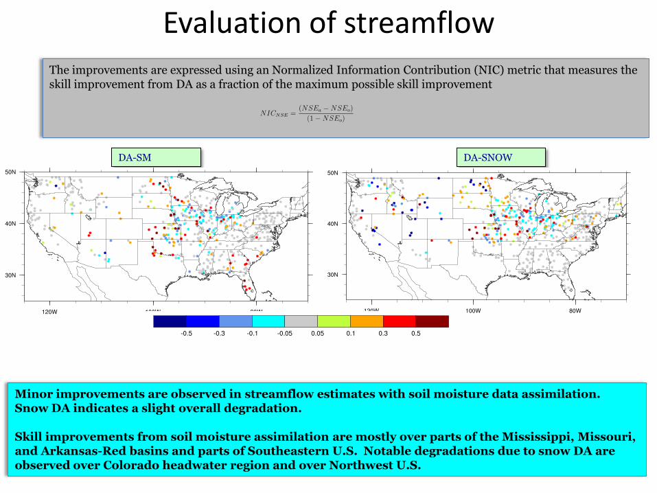
Evaluation of streamflow
The improvements are expressed using an Normalized Information Contribution (NIC) metric that measures the skill improvement from DA as a fraction of the maximum possible skill improvement
DA-SM DA-SNOW
Minor improvements are observed in streamflow estimates with soil moisture data assimilation. Snow DA indicates a slight overall degradation. Skill improvements from soil moisture assimilation are mostly over parts of the Mississippi, Missouri, and Arkansas-Red basins and parts of Southeastern U.S. Notable degradations due to snow DA are observed over Colorado headwater region and over Northwest U.S.
NSE
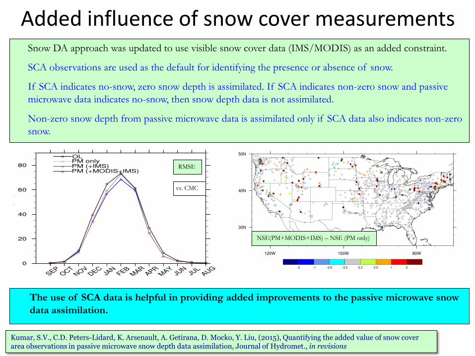
Added influence of snow cover measurements
Kumar, S.V., C.D. Peters-Lidard, K. Arsenault, A. Getirana, D. Mocko, Y. Liu, (2015), Quantifying the added value of snow cover area observations in passive microwave snow depth data assimilation, Journal of Hydromet., in revisions
Snow DA approach was updated to use visible snow cover data (IMS/MODIS) as an added constraint.
SCA observations are used as the default for identifying the presence or absence of snow.
If SCA indicates no-snow, zero snow depth is assimilated. If SCA indicates non-zero snow and passive
microwave data indicates no-snow, then snow depth data is not assimilated.
Non-zero snow depth from passive microwave data is assimilated only if SCA data also indicates non-zero
snow.
NSE(PM+MODIS+IMS) – NSE (PM only)
The use of SCA data is helpful in providing added improvements to the passive microwave snow
data assimilation.
vs. CMC
RMSE
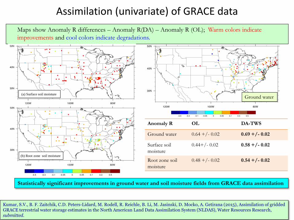
Assimilation (univariate) of GRACE data
Maps show Anomaly R differences – Anomaly R(DA) – Anomaly R (OL); Warm colors indicate
improvements and cool colors indicate degradations.
Ground water
Anomaly R OL DA-TWS
Ground water 0.64 +/- 0.02 0.69 +/- 0.02
Surface soil
moisture
0.44+/- 0.02 0.58 +/- 0.02
Root zone soil
moisture
0.48 +/- 0.02 0.54 +/- 0.02
Statistically significant improvements in ground water and soil moisture fields from GRACE data assimilation
Kumar, S.V., B. F. Zaitchik, C.D. Peters-Lidard, M. Rodell, R. Reichle, B. Li, M. Jasinski, D. Mocko, A. Getirana (2015), Assimilation of gridded GRACE terrestrial water storage estimates in the North American Land Data Assimilation System (NLDAS), Water Resources Research, submitted.
(a) Surface soil moisture
(b) Root zone soil moisture
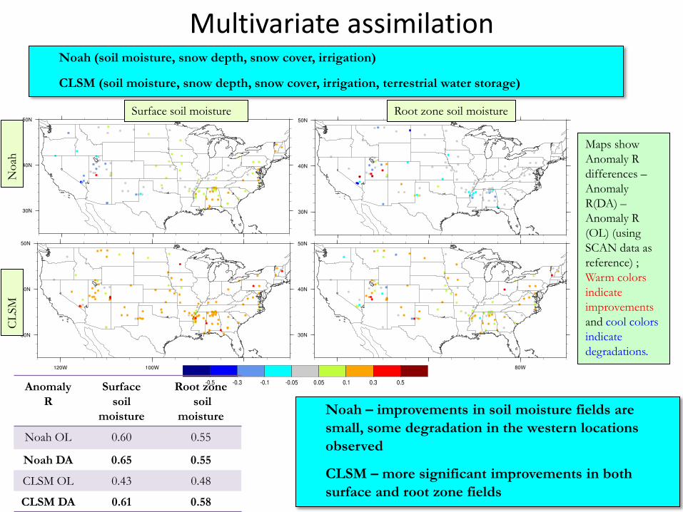
Multivariate assimilation
Noah (soil moisture, snow depth, snow cover, irrigation)
CLSM (soil moisture, snow depth, snow cover, irrigation, terrestrial water storage)
Surface soil moisture Root zone soil moisture
No
ah
CL
SM
Noah – improvements in soil moisture fields are
small, some degradation in the western locations
observed
CLSM – more significant improvements in both
surface and root zone fields
Anomaly
R
Surface
soil
moisture
Root zone
soil
moisture
Noah OL 0.60 0.55
Noah DA 0.65 0.55
CLSM OL 0.43 0.48
CLSM DA 0.61 0.58
Maps show
Anomaly R
differences –
Anomaly
R(DA) –
Anomaly R
(OL) (using
SCAN data as
reference) ;
Warm colors
indicate
improvements
and cool colors
indicate
degradations.
LIS-NLDAS plans
• Transfer LIS7 to Youlong and others at EMC
• Complete SAC-HTET parameters and Noah-MP (configuration TBD)
• NLDAS Benchmarking system using LVT
• Perform probabilistic drought analysis with LIS7-UE
• Add NCAR’S latest CLM model
• Test new satellite products/radiances for data assimilation (SMAP, IMS, AMSR-2, etc.)


![The North American Land Data Assimilation System (NLDAS) · 2019. 5. 13. · Fluxes and States Kristi R. Arsenault[1,3], David M. Mocko[1,3] ... 30-year output from these NLDAS-based](https://img.dokumen.tips/doc/110x75/60f8bae298a4ca763714841b/the-north-american-land-data-assimilation-system-nldas-2019-5-13-fluxes-and.jpg)