Embed Size (px)
Citation preview

Ohio Department of Natural ResourcesDivision of Watercraft
ohiodnr.com/watercraftRevised 1/2013
Eastern Ohio Streams Access
£40
£36
£22
£33
MUSKINGUMCOSHOCTON
TUSCARAWAS
GUERNSEY
NOBLE
WASHINGTON
ATHENS
MORGAN
Zanesville
Marietta
Coshocton
Cambridge
Belpre
New Comerstown
New Concord
McConnelsville
Caldwell
Philo
Beverly
Coolville
Athens
Warsaw
Plainfield
Lore City
Conesville
11
Dresden
!1
!2
3!4
!5!6
8
!7!9!10
!12
!13
!14Blue Rock
!15
!16
18 !17
!19 !20
21 !22
!23!24
!25Stockport 26
!2729
!28!30 31 !32
Lowell
33
!34
Devola 35
!36
!37!38
!39
Rockeby Lock
208
7
144
285
83
93
146
643
676
751
339
662
78
550
340
669
258
541
77377
658
70
215
530
284
16
621
329
574313
37
821
566
792
124
672
660
564
209
265
93
78
690
550
313
555
285
60
339
340
60
83
541
5 5 102.5 0 Miles
Muskingum River
Legend
River
Scenic River
Watertrail
Access Point
Hazard
Dam
State Route
U.S. Route
Interstate
City
Parking Lot
Roadside Parking
ADA Accessible
Launch Ramp
Camping
Bike Trail
Food
Picnic
Restrooms
Drinking Water
Canoe Rental
North
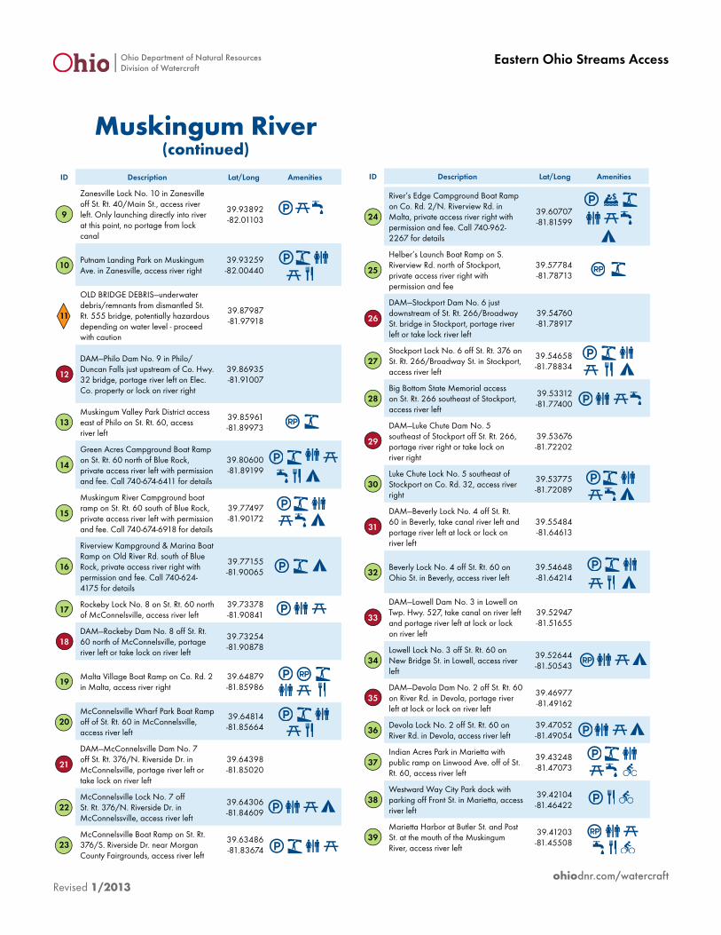
ID Description Lat/Long Amenities
1
Coshocton City Boat Ramp on S. 2nd St./Co. Rd. 271 by Coshocton Sewage Treatment Plant, access river left
40.24138 -81.87270
2Dresden Boat Ramp on Muskingum Ave./St. Rt. 208 in Dresden, access river right
40.11937 -82.00097
3
DAM—Ellis Dam No. 11 north of Zanesville. LOCK IS NOT OPERATIONAL, PADDLERS MUST TAKE OUT RIVER RIGHT
40.04313 -81.97710
4Ellis Lock No. 11 boat ramp north of Zanesville on Ellis Dam Rd., access river right
40.04325 -81.97877
5
Kirkbride Boating Company Boat Ramp on Linden Ave. in Zanesville, access river right with permission and fee. Call 740-453-2798 for details
39.97281 -81.99387
6Riverside Park off St. Rt. 666/N. River Rd. in Zanesville, access river left
39.96091 -81.99387
7Zane’s Landing Park access on Market St. in Zanesville, access river left
39.94353 -82.01057
8
DAM—Main St. bridge dam for Lock #10. Must take canal at river left of dam and lock through or portage to river from canal at lock tenders house and dock
39.94174 -82.01280
Continued on Next Page
Ohio Department of Natural ResourcesDivision of Watercraft
ohiodnr.com/watercraftRevised 1/2013
Eastern Ohio Streams Access
ID Description Lat/Long Amenities
9
Zanesville Lock No. 10 in Zanesville off St. Rt. 40/Main St., access river left. Only launching directly into river at this point, no portage from lock canal
39.93892 -82.01103
10Putnam Landing Park on Muskingum Ave. in Zanesville, access river right
39.93259 -82.00440
11
OLD BRIDGE DEBRIS—underwater debris/remnants from dismantled St. Rt. 555 bridge, potentially hazardous depending on water level - proceed with caution
39.87987 -81.97918
12
DAM—Philo Dam No. 9 in Philo/Duncan Falls just upstream of Co. Hwy. 32 bridge, portage river left on Elec. Co. property or lock on river right
39.86935 -81.91007
13Muskingum Valley Park District access east of Philo on St. Rt. 60, access river left
39.85961 -81.89973
14
Green Acres Campground Boat Ramp on St. Rt. 60 north of Blue Rock, private access river left with permission and fee. Call 740-674-6411 for details
39.80600 -81.89199
15
Muskingum River Campground boat ramp on St. Rt. 60 south of Blue Rock, private access river left with permission and fee. Call 740-674-6918 for details
39.77497 -81.90172
16
Riverview Kampground & Marina Boat Ramp on Old River Rd. south of Blue Rock, private access river right with permission and fee. Call 740-624-4175 for details
39.77155 -81.90065
17Rockeby Lock No. 8 on St. Rt. 60 north of McConnelsville, access river left
39.73378 -81.90841
18DAM—Rockeby Dam No. 8 off St. Rt. 60 north of McConnelsville, portage river left or take lock on river left
39.73254 -81.90878
19Malta Village Boat Ramp on Co. Rd. 2 in Malta, access river right
39.64879 -81.85986
20McConnelsville Wharf Park Boat Ramp off of St. Rt. 60 in McConnelsville, access river left
39.64814 -81.85664
21
DAM—McConnelsville Dam No. 7 off St. Rt. 376/N. Riverside Dr. in McConnelsville, portage river left or take lock on river left
39.64398 -81.85020
22McConnelsville Lock No. 7 off St. Rt. 376/N. Riverside Dr. in McConnelssville, access river left
39.64306 -81.84609
23McConnelsville Boat Ramp on St. Rt. 376/S. Riverside Dr. near Morgan County Fairgrounds, access river left
39.63486 -81.83674
24
River’s Edge Campground Boat Ramp on Co. Rd. 2/N. Riverview Rd. in Malta, private access river right with permission and fee. Call 740-962-2267 for details
39.60707 -81.81599
25
Helber’s Launch Boat Ramp on S. Riverview Rd. north of Stockport, private access river right with permission and fee
39.57784 -81.78713
26
DAM—Stockport Dam No. 6 just downstream of St. Rt. 266/Broadway St. bridge in Stockport, portage river left or take lock river left
39.54760 -81.78917
27Stockport Lock No. 6 off St. Rt. 376 on St. Rt. 266/Broadway St. in Stockport, access river left
39.54658 -81.78834
28Big Bottom State Memorial access on St. Rt. 266 southeast of Stockport, access river left
39.53312 -81.77400
29
DAM—Luke Chute Dam No. 5 southeast of Stockport off St. Rt. 266, portage river right or take lock on river right
39.53676 -81.72202
30Luke Chute Lock No. 5 southeast of Stockport on Co. Rd. 32, access river right
39.53775 -81.72089
31
DAM—Beverly Lock No. 4 off St. Rt. 60 in Beverly, take canal river left and portage river left at lock or lock on river left
39.55484 -81.64613
32Beverly Lock No. 4 off St. Rt. 60 on Ohio St. in Beverly, access river left
39.54648 -81.64214
33
DAM—Lowell Dam No. 3 in Lowell on Twp. Hwy. 527, take canal on river left and portage river left at lock or lock on river left
39.52947 -81.51655
34Lowell Lock No. 3 off St. Rt. 60 on New Bridge St. in Lowell, access river left
39.52644 -81.50543
35DAM—Devola Dam No. 2 off St. Rt. 60 on River Rd. in Devola, portage river left at lock or lock on river left
39.46977 -81.49162
36Devola Lock No. 2 off St. Rt. 60 on River Rd. in Devola, access river left
39.47052 -81.49054
37Indian Acres Park in Marietta with public ramp on Linwood Ave. off of St. Rt. 60, access river left
39.43248 -81.47073
38Westward Way City Park dock with parking off Front St. in Marietta, access river left
39.42104 -81.46422
39Marietta Harbor at Butler St. and Post St. at the mouth of the Muskingum River, access river left
39.41203 -81.45508
Muskingum River(continued)
ID Description Lat/Long Amenities