Embed Size (px)
Citation preview

Global Disaster Risk Identification: Nepal
Municipal Disaster Risk Identification Program (MDRIP)
Ilam and Panauti Municipalities of Nepal
Final Report
Submitted to:
GLOBAL RISK IDENTIFICATION PROGRAMME (GRIP) Bureau for Crisis Prevention and Recovery United Nations Development Programme 11 - 13 Chemin des Anémones, CH - 1219 Châtelaine, Geneva, Switzerland Tel: +41 22 917 8399 Fax : +41 22 917 8060 website : www.gripweb
Submitted by:
National Society for Earthquake Technology – Nepal (NSET) Sainbu VDC, Ward Number 4, Bhainsepati Residential Area, Lalitpur, Nepal GPO Box: 13775, Kathmandu, Nepal Telephone: (+977-1) 5591000, (+977-1) 5593000, (+977-1) 5592522 Fax: (+977-1) 5592692, (+977-1) 5592693 Email: [email protected] URL: www.nset.org.np
September 2009, Kathmandu

Final Report: Municipal Disaster Risk Identification Program (MDRIP)
Ilam and Panauti Municipalities, Nepal I
Prepared & submitted to GRIP by National Society for Earthquake Technology-Nepal (NSET)
Foreword Development of earthquake damage scenario for Quito (in early 1990s was a great motivation for NSET to implement the Kathmandu Valley Earthquake Risk Management Program (KVERMP) during 1997-1999 under the Asian Urban Disaster Mitigation Program managed by ADPC with core funding from the US Office of Foreign Disaster Assistance (OFDA) – a subset of the US Agency for International Development (USAID). KVERMP consisted of earthquake damage estimation for a scenario earthquake, action planning to manage the risk, and implementation of earthquake awareness programs including demonstration projects such as seismic retrofitting of public schools. The program was successful as it established a replicable methodology for earthquake risk assessment in cities of developing countries. Several innovative concepts, implementation processes, standards and strategies for disaster risk reduction could be developed that were found suitable for a weak-economy developing country Nepal. Community understanding and participation in the project initiatives was emphasized opening avenues for uncovering of traditional wisdom in earthquake-resistant construction. The result was development of a cost-effective methodology of risk assessment and implementation strategies for risk reduction such as mason training, community-based school earthquake safety program, annual “Earthquake Safety Day” observation, “vulnerability tour” along narrow Kathmandu streets for assisting community representatives to better understand and perceive earthquake risk, training of housewives for earthquake risk reduction, and so on. These methodologies and program were subsequently replicated, in full or part, in several municipalities of Nepal successfully. With growing earthquake awareness, local municipal governments as well as public schools and communities started demanding for better knowledge and awareness.
On the other hand, the urbanization process in Nepal has been very rapid in the past decade due to various political (insurgencies), economic and social reasons. More building are being constructed, which in the lack of proper municipal capacities in building code implementation and also the low level of awareness at all levels are resulting in rapid built up of vulnerabilities which needs to be stopped on an urgent basis.
Further, the need for factoring disaster sensitivity in planning and implementation of urban land use planning and infrastructure development works as well as in poverty reduction efforts is being realized by the central and district administrations. Thus the district headquarters are the hubs of development, and they are also gradually being declared as municipalities where urban amenities are being gradually provided. These are the centres of rapid growth of population concentration and unprecedented pace of building construction and infrastructure development. Under such dynamism of urbanization, it is necessary to stop further built-up of structural and non-structural vulnerabilities to earthquake and other disasters.
NSET implements a Municipal Earthquake Risk Management Program (MERMP) that seeks to work with and assist the municipal governments to identify the prevalent natural (or anthropogenic) hazards, conduct risk assessment, and develop action plans for short- and long-term disaster risk reduction. With Ilam and Panauti, the total number of municipalities that NSET has assisted to develop earthquake risk and develop action plan reaches 7. NSET hopes to provide continued assistance to the remaining municipalities so that Nepal could publish an Urban Disaster Risk Atlas of Nepal in the next 3 to 4 years to cover all 58 municipalities and rapidly urbanising settlements.
MDRIP is an important milestone in this endeavour of urban risk assessment and reduction in Nepal. Partnership with GRIP/UN in this project has been very successful. Further, this endeavour has provided for further enrichment of the methodologies and opened new avenues for development of replicable disaster risk assessment tools useful for developing countries.

Final Report: Municipal Disaster Risk Identification Program (MDRIP)
Ilam and Panauti Municipalities, Nepal II
Prepared & submitted to GRIP by National Society for Earthquake Technology-Nepal (NSET)
Acknowledgements The success of MDRIP owes to the support received from Ilam and Panauti municipalities in the form of full engagement in- and accepting ownership of the project activities and outcomes by the local residents and the municipalities. In both municipalities, the all-party mechanism (an informal body consisting of representatives of all major political parties; the mechanism makes decision based on consensus on all strategic and program-related issues. This is a makeshift arrangement in lieu of the elected government which is non-existent in Nepal currently because local political elections have not been held for the past 8 years). The National Society for Earthquake Technology – Nepal (NSET) expresses its appreciation to the members of the political all-party mechanisms in Ilam and Panauti municipalities represented by the political parties Jana Morcha Nepal, Nepal Communist Party United Maoist, Nepal Communist Party United Marxist—Leninist, Nepal Communist Party (Marxist), Nepal Majdoor Kisan Party and the Nepali Congress of Ilam and Panauti branches of the parties. They provided important guidance to the project, contributed to the scenario/action planning workshops and actively participated in other awareness-raising activities. Sincere gratitude is expressed to the Chief Executive Officers (CEO) of Panauti and Ilam Municipalities Messer’s Bhim Prasad Poudel and Mr. Atma Ram Satyal for facilitating the all-party process, for the administrative support accorded to the project by the municipalities, and for their continuous involvement in program activities and the encouragement provided to the project team. NSET extends our appreciation also to the Chief District Officers of Ilam and Panauti Municipalities, respectively Mr. Sudershan Prasad Dhakal Mr. Netra Prasad Neupane, for his wholehearted support to the program and for gracing several activities with their presence. Acknowledgements are also due to the leaders and staff of several governments, non-governmental and private organizations operating in and from the municipalities. Senior representatives of these institutions took keen interest in project activities, discussed the issues and provided relevant data and maps. Representatives of commerce and industry, business person, women’s groups, NGOs and INGOs, academic institutions, army and the police, media including the local FM radio stations (Nepal Vani and Ilam FM) all contributed to the project activities. It is impossible to acknowledge the credits of all individuals; their list appears in Annexes 5 and 6. We thank GRIP UNDP/BCPR team, especially Dr. Carlos Villacis, Global Risk Identification Programme (GRIP) Coordinator, Disaster Reduction and Recovery Unit, Bureau for Crisis Prevention and Recovery for endorsing our past efforts in urban earthquake risk assessment by providing this opportunity to implement MDRIP in Nepal, for his continuous encouragement for the use of RADIUS tool, and for guidance during project implementation. Sincere acknowledgements are also due to Surya Narayan Shrestha and Mr. Ramesh Guragain, for discussion on the methodology and for continuous guidance during the study. Sincere acknowledgements are also due to Mr. Dila Ram Sapkota, Mr. Nandalal Khatiwoda, and Mr. Suresh Chaudhary, who worked with NSET as interns for the building inventory of Ilam Municipality, which they conducted as part of their field survey for the preparation of a research thesis to fulfil the partial requirements for a Masters Degree in Geography of Tribhuvan University. Mr. Chaudhary subsequently joined NSET as a staff and got involved in the project works. We appreciate also the cooperation extended by the Chairperson Prof. Dr. Bhim Prasad Subedi of the Central Department of Geography (CDG), Tribhuvan University, for furthering such collaboration between CDG and NSET. The study was done by a team of professionals of NSET, led by Mr. Surya Narayan Shrestha, Deputy Executive Director; Mr. Bijay Kumar Upadhyaya, Specialist on Community-based Disaster Risk Management, and Mr. Suresh Chaudhary, Geographer and GIS Specialist. Their hard work was instrumental in implementing the project successfully. Several other professionals of NSET, namely, Ram Chandra Kandel, Surya Prasad Acharya, Niva Upreti, assisted the team either in the field or in home office. NSET expresses its sincere appreciation to all team members for their contributions, despite data and resources constraints. NSET would also like to acknowledge the excellent coordination and cooperation extended by Mr. Prem Kumar Sonam, Engineer, Panauti Municipality and Mr. Bhim Prasad Dhungana, Assistant Sub-Engineer, Ilam Municipality, who were assigned to the MDRIP project by the municipalities with responsibilities coordination of MDRIP activities

Final Report: Municipal Disaster Risk Identification Program (MDRIP)
Ilam and Panauti Municipalities, Nepal III
Prepared & submitted to GRIP by National Society for Earthquake Technology-Nepal (NSET)
Abbreviations
amsl above mean sea level BCPR Bureau for Crisis Prevention and Recovery CBS Central Bureau of Statistics, Nepal CDO Chief District Officer CDRC Central Disaster Relief Committee CRA 1982 Calamity Relief Act, 1982 DDRC District Disaster Relief Committee DesInventar Disaster Inventory. A software and a system of disaster information management System DIG Disaster Imagination Game DIMS Disaster Information Management System DMG Department of Mines and Geology DOHM Department of Hydrology and Meteorology DRR Disaster Risk Reduction DUDBC Department of Urban Development and Building Construction, Government of Nepal DWIDP Department of Water Induced Disaster Prevention GDP Gross Domestic Product GIS Geographical Information System
GLOF Glacier Lakes Outburst Floods GON Government of Nepal GRIP Global Risk Identification Program HAZUS Hazard US – an Earthquake hazard risk assessment tool HDI Human Development Index HFA Hyogo Framework for Action 2005-2015 HFF Himalayan Frontal Fault System ICIMOD International Center for Integrated Mountain Development IDNDR International Decade for Natural Disaster Reduction ISDR International Strategy for Disaster Reduction ISZ Indus Suture Zone LARED Latin American Network of Social Studies on Disaster Prevention LDO Local Development Officer LDRC Local Disaster Relief Committee MBT Main Boundary Thrust Fault MCT Main Central Thrust Fault System MDG Millennium Development Goal

Final Report: Municipal Disaster Risk Identification Program (MDRIP)
Ilam and Panauti Municipalities, Nepal IV
Prepared & submitted to GRIP by National Society for Earthquake Technology-Nepal (NSET)
MDRIP Municipal Disaster Risk Identification Project MERMP Municipal Disaster Risk Management Program MMI Modified Mercalli Intensity Scale (of earthquake shaking) MOHA Ministry of Home Affairs MT Metric Ton NBC National Building Code of Nepal NEA Nepal Electricity Authority NR Nepalese Rupees NRCS Nepal Red Cross Society NSDRM National Strategy for Disaster Risk Management NSET National Society for Earthquake Technology - Nepal OFDA Office of Foreign Disaster Assistance PRSP Poverty Reduction Strategy Paper PVA Participatory Vulnerability Assessment RADIUS Risk Assessment Tools for Diagnosis of Urban Areas against Seismic Disasters RDRC Regional Disaster Relief Committee UNDP United Nations Development Programme UNOPS United Nations Office for Project Services VDC Village Development Committees

Final Report: Municipal Disaster Risk Identification Program (MDRIP)
Ilam and Panauti Municipalities, Nepal V
Prepared & submitted to GRIP by National Society for Earthquake Technology-Nepal (NSET)
Table of Contents Foreword I
Acknowledgements ............................................................................................................................ II
1. INTRODUCTION ........................................................................................................................... 1 1.1 General ................................................................................................................................................ 1
1.2 Related Initiatives and Importance of MDRIP ...................................................................................... 1
1.3 MDRIP Objectives ............................................................................................................................... 3
1.4 Scope of the Current Phase of MDRIP ................................................................................................ 3
1.5 Approach and Methodology ................................................................................................................. 4
1.6 Structure of This Report ....................................................................................................................... 6
2. NATIONAL AND MUNICIPAL BACKGROUND .......................................................................... 7 2.1 National Background ........................................................................................................................... 7
2.2 Profile of Ilam Municipality ................................................................................................................. 13
2.3 Profile of Panauti Municipality ............................................................................................................ 19
3. DISASTER RISK OF PROJECT MUNICIPALITIES .................................................................. 25 3.1 Structural Vulnerability of Groups of Buildings ................................................................................... 25
3.2 Disaster Risk of Ilam Municipality ...................................................................................................... 31
3.3 Disaster Risk of Panauti Municipality ................................................................................................. 42
4. DISASTER RISK MANAGEMENT ACTION PLANNING .......................................................... 53 4.1 Plan Creators ..................................................................................................................................... 53
4.2 Planning Process ............................................................................................................................... 53
4.3 Disaster Risk Reduction Action Plan for Ilam Municipality ................................................................. 54
4.4 Disaster Risk Reduction Action Plan for Panauti Municipality ........................................................... 56
5. IMPACT AND LESSONS LEARNED ......................................................................................... 58 5.1 The Initial Impacts.............................................................................................................................. 58
5.2 Lessons learned ................................................................................................................................ 59
6. CONCLUSIONS & NEXT STEPS .............................................................................................. 61 6.1 Conclusions ....................................................................................................................................... 61
6.2 Recommendations ............................................................................................................................. 61
7. REFERENCES ............................................................................................................................ 63

Final Report: Municipal Disaster Risk Identification Program (MDRIP)
Ilam and Panauti Municipalities, Nepal VI
Prepared & submitted to GRIP by National Society for Earthquake Technology-Nepal (NSET)
List of Tables
Table 1: Demographic and socio-economic indicators of Nepal .............................................. 9
Table 2: Types of natural and human-induced hazards in Nepal ............................................ 12
Table 3: Demographic and Socio-economic indicators of Ilam Municipality ..................... 15
Table 4: Potential Earthquake Sources Considered for Selecting the Scenario Earthquake16
Table 5: Land Use of Ilam Municipality ..................................................................................... 17
Table 6: Disaster records for Ilam District, 1971-2007 ............................................................. 18
Table 7: Disaster Events for Ilam Municipality 1971-2007 ....................................................... 19
Table 8: Demographic and Socio Indicators of Panauti Municipality ..................................... 21
Table 9: Physical Infrastructures in Panauti Municipality ....................................................... 21
Table 10: Land Use Pattern in Panauti Municipality ................................................................... 23
Table 11: Disaster records for Kavre district, 1971-2007 ........................................................... 24
Table 12: Disaster events for Panauti Municipality, 1971-2007 ................................................. 24
Table 13: Building floors classified by space use ...................................................................... 26
Table 14: Age classification of the buildings .............................................................................. 27
Table 15: Buildings height ............................................................................................................ 28
Table 16: Building geometry ......................................................................................................... 28
Table 17: Building classification by construction materials ..................................................... 29
Table 18: Condition of the buildings ............................................................................................ 30
Table 19: Attachments of the buildings ....................................................................................... 30
Table 20: Earthquake Loss Estimation for Ilam Municipality - Casualty and Building Damage ......................................................................................................................................... 32
Table 21: Earthquake Loss Estimation for Ilam Municipality - Physical Infrastructure Damage ......................................................................................................................................... 32
Table 22: Details on Other Hazards and Risks in Ilam Municipality ......................................... 41
Table 23: Earthquake Loss Estimation for Panauti Municipality - Casualty and Building Damage ........................................................................................................................... 43
Table 24: Earthquake Loss Estimation for Panauti Municipality - Physical Infrastructure Damage ........................................................................................................................... 43
Table 25: Details on Other Hazards and Risks in Panauti Municipality ................................... 51
Table 26: Priority Actions for Disaster Risk Management: Ilam Municipality.......................... 54
Table 27: Priority Actions for Disaster Risk Management: Panauti Municipality .................... 56

Final Report: Municipal Disaster Risk Identification Program (MDRIP)
Ilam and Panauti Municipalities, Nepal VII
Prepared & submitted to GRIP by National Society for Earthquake Technology-Nepal (NSET)
List of Figures
Figure 1: Panauti and Ilam Municipalities among the Municipalities in Nepal .......................... 4
Figure 2: Nepal – location and administrative divisions ............................................................. 7
Figure 3: Trend of population growth in Nepal 1971 – 2021...................................................... 10
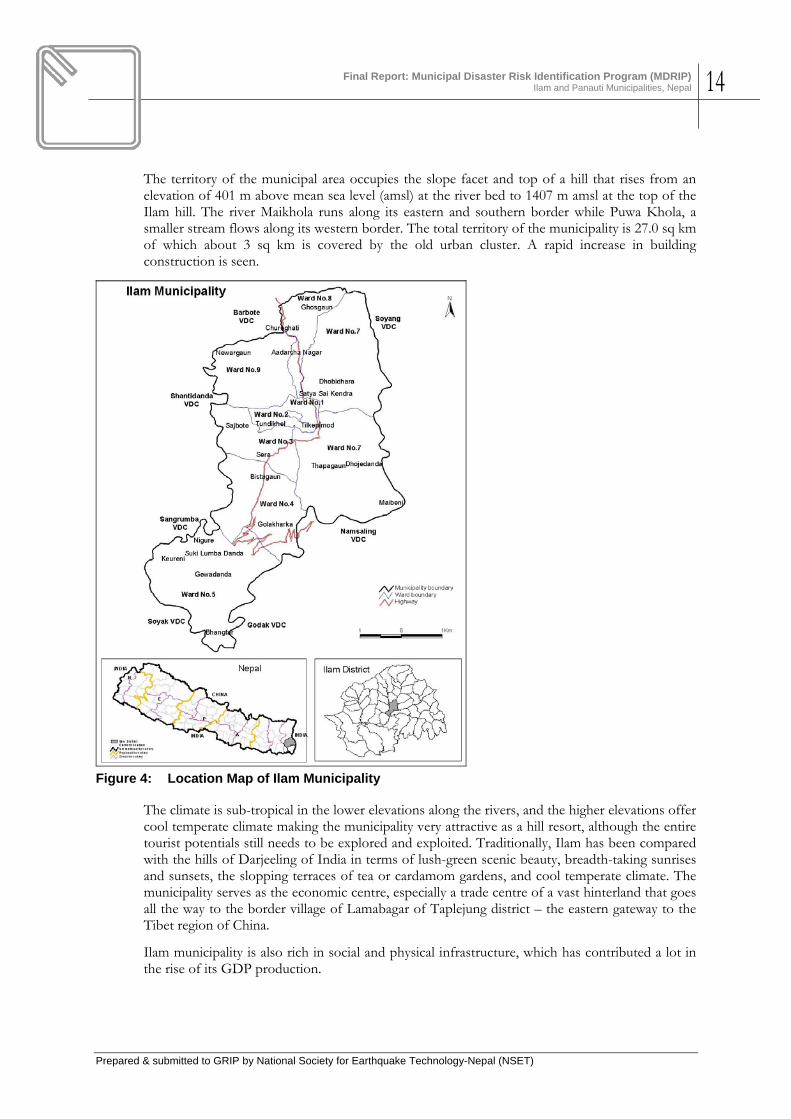
Figure 4: Location Map of Ilam Municipality ............................................................................... 14
Figure 5: Geologic and Soil Map of Ilam Municipality ............................................................... 16
Figure 6: Map of Active Faults of Eastern Nepal ........................................................................ 17
Figure 7: Land Use Map of Ilam Municipality .............................................................................. 18
Figure 8: Map of Panauti Municipality ......................................................................................... 20
Figure 9: Geologic Map of Panauti Area...................................................................................... 22
Figure 10: Land Use Map of Panauti Municipality ........................................................................ 23
Figure 11: Building Footprint Map of Ilam Municipality ............................................................... 25
Figure 12: Building floors classified by space use ...................................................................... 26
Figure 13: Age classification of the buildings .............................................................................. 27
Figure 14: Buildings heights .......................................................................................................... 28
Figure 15: Building classification by construction materials ..................................................... 29
Figure 16: Condition of the buildings ............................................................................................ 30
Figure 17: Attachments of the buildings ....................................................................................... 31
Figure 18: Scenario Earthquake Shaking Intensity ...................................................................... 33
Figure 19: Distribution of Building Damage due to Scenario Earthquake in Ilam .................... 34
Figure 20: Death due to Scenario Earthquake in Ilam Day time) ................................................ 35
Figure 21: Death due to Scenario Earthquake in Ilam (Night time) ............................................ 36
Figure 22: Injury due to Scenario Earthquake in Ilam (Night time) ............................................ 37
Figure 23: Death due to Scenario Earthquake in Ilam (Night time) ............................................ 38
Figure 24: Injury due to Scenario Earthquake in Ilam (Day time) ............................................... 39
Figure 25: Injury due to Scenario Earthquake in Ilam (Day time) ............................................... 40
Figure 26: Hazards in Ilam Municipality ........................................................................................ 42
Figure 27: Scenario Earthquake Shaking Intensity ...................................................................... 44
Figure 28: Distribution of Building Damage due to Scenario Earthquake in Panauti .............. 45
Figure 29: Death due to Scenario Earthquake in Panauti (Day time) ......................................... 46
Figure 30: Death due to Scenario Earthquake in Panauti (Night time) ...................................... 47
Figure 31: Injury due to Scenario Earthquake in Panauti (Day time) ......................................... 48
Figure 32: Injury due to Scenario Earthquake in Panauti (Night time) ....................................... 49
Figure 33: Participatory Hazard Risk Assessment in Panauti Municipality .............................. 50
Figure 34: House is Safer due to Erection of a New Pole ............................................................ 58
Final Report: Municipal Disaster Risk Identification Program (MDRIP)
Ilam and Panauti Municipalities, Nepal VIII
Prepared & submitted to GRIP by National Society for Earthquake Technology-Nepal (NSET)
Figure 35: A new building with incorporation of earthquake-resistant elements learnt from MDRIP training ............................................................................................................... 58
Annex
Annex 1. Details of Works Carried Out ........................................................................................ 65
Annex 2. Copies of Memoranda of Understanding with the Municipalities ............................ 72
Annex 3. Long List of Initiatives for Disaster Risk Reduction Action PlanNing – ILAM Municipality .................................................................................................................... 76
Annex 4. Long List of Initiatives for Disaster Risk Reduction Action PlanNing – Panauti Municipality .................................................................................................................... 79
Annex 5. List of Action Plan Contributors- Ilam Municipality ................................................... 85
Annex 6. List of Action Plan Contributors- Panauti Municipality ............................................. 87

Final Report: Municipal Disaster Risk Identification Program (MDRIP)
Ilam and Panauti Municipalities, Nepal 1
Prepared & submitted to GRIP by National Society for Earthquake Technology-Nepal (NSET)
1. INTRODUCTION
1.1 General
This report is a summary of the approach, methodology, results and conclusions of work conducted to identify and characterize potential natural hazards within and surrounding the two municipalities of Ilam and Panauti of Nepal, to assess the risks associated with the hazards, especially seismic risk, and to assist the two municipalities to develop action plans for earthquake risk reduction and emergency response planning under the Municipal Disaster Risk Identification Project (MDRIP). The National Society for Earthquake Technology – Nepal (NSET) implemented the risk identification project in close collaboration with the project municipalities along with a variety of stakeholders in the two municipalities, and national level government institutions. This project was conducted under the High Resolution Risk Analysis stream of activities of the Global Risk Identification Programme (GRIP), a program launched by UNDP highlighting the importance of Disaster Risk Reduction in achieving the Millennium Goals. GRIP’s objectives are an improved evidence base for disaster risk management and an increased adoption of risk evidence in disaster risk management and development processes. GRIP targets areas of the world where disaster is a major factor in reducing sustainable development.
This, report puts forward the activities carried out and achievements made within 27 March 2009 from the in between NSET and UNOPS/GRIP signed an agreement on 13 Feb 08 to implement MDRIP in Ilam and Panauti municipalities of Nepal.
1.2 Related Initiatives and Importance of MDRIP
Nepal is a high risk country in terms of natural hazards. Earthquake, flood, landslide and fires are the mains hazards that inflict heavy losses in terms of lives lost and property damaged every year. Therefore, Nepal is one of the project countries of GRIP.
This project also closely relates with the concept and vision of NSET towards assessment and management of disaster risks in urban areas of Nepal. Following the experience of Quito, Ecuador, NSET implemented a Kathmandu Valley Earthquake Risk Management Program during 1997-1999 (NSET 19981, NSET 19982 ). The program deliverables included an earthquake damage assessment (loss estimation for a scenario earthquake), and earthquake risk management action plan, earthquake awareness activities and a school earthquake safety program (SESP). Success of KVERMP resulted in a close collaborative contact with the then RADIUS program for urban earthquake risk assessment implemented by the UN IDNDR during 1997-1999, and replication of the KVERMP methodologies in cities within and outside Nepal. Since then, NSET has undertaken earthquake risk assessment in several cities in Nepal, in Chittagong, Dhaka and Sylhet of Bangladesh and Muzaffarabad, Mansehra and Quetta of Pakistan. A suite of methodologies for earthquake risk assessment has been developed in this course. The methodologies include successful use of RADIUS tool, GIS, and such sophisticated tool as HAZUS, all modified and adapted to the local situation of information availability and the objective of risk assessment. In the mean time, NSET expanded the scope of risk assessment to cover all principle hazards faced by the particular city. Such rich experiences of NSET prompted it to embark upon a program Urban Disaster Risk Atlas of Nepal. This project on municipal disaster risk identification program (MDRIP) thus fit well with the aspiration of NSET, and contributed much to addressing the need for urban disaster risk assessment in Nepal.

Final Report: Municipal Disaster Risk Identification Program (MDRIP)
Ilam and Panauti Municipalities, Nepal 2
Prepared & submitted to GRIP by National Society for Earthquake Technology-Nepal (NSET)
Further, MDRIP activities strengthen and provide important inputs to the long-term Municipal Disaster Risk Management Program (MERMP) of NSET. (NSET) has developed and adopted Community Based Municipal Disaster Risk Reduction Approaches for the existing municipalities and other fast growing urban centres of Nepal. It envisages preparing a generic Earthquake Risk Atlas of the existing 58 municipalities of Nepal within the coming three to five years. NSET has already done some works pertaining to gathering information for the atlas. It has also assisted around a dozen municipalities to initiate disaster risk reduction at the municipal level in and has received positive response. Thus, MERMP is conceptualized and implemented as a continuous process which will add on to the aim of creating urban centres capable of effective and efficient disaster reduction and response.
Urban areas of Nepal face a multitude of natural hazards viz. earthquake, landslide, flood, epidemics, urban and wild fire, etc. The project however, focuses primarily on Earthquake Risk Reduction. This choice is based on the experience and consensus premise that capacity building and preparedness against earthquakes could form the starting point for subsequent work on disaster risk reduction for other forms of natural hazards on the systems and mechanisms to deal with earthquake risk.
Activities proposed in MDRIP are based on the rich experiences of NSET in implementing earthquake risk management programs in Kathmandu Valley and other cities of Nepal, as well as on the experiences of capacity building and institutionalization of disaster risk reduction in Pakistan, Iran, Afghanistan, India, and Banda Aceh of Indonesia. Several innovative methodologies were developed for risk assessment, action planning and implementation, awareness raising and capacity building and disaster risk management master planning for municipalities. Rich experiences have been gained by NSET also in the use of Risk Assessment Tools for Diagnosis of Urban Areas against Seismic Disasters (RADIUS) for earthquake risk assessment, action planning for risk reduction and earthquake preparedness for several municipalities and also in municipal wards. Thus the feasibility for the use of RADIUS as a methodological tool has been demonstrated continuously.
Further NSET has started a systematic inventory of disaster data for Nepal based on the methodology of DesInventar, a methodological tool developed by Latin American Network of Social Studies on Disaster Prevention (LARED). So far, this disaster information management system (DIMS) has collected and analyzed disaster date during 1970-2007 and the process in continuation. Within this system NSET is constantly updating all the events and has the data based updated till date.
The planned activities under the project thus form a logical continuation of the past initiatives and replication of successful initiatives, and seeks to build upon the achievements so that disaster risk reduction could be achieved in the most cost-effective and optimal way in the urban areas of Nepal.
The existing 58 municipalities of Nepal can be classified into three major categories based on their current status in terms of tier capacities in disaster risk reduction. To the first category belong a few municipalities that are well aware about the issue and have started implementing disaster risk reduction initiatives. To the second category belong some `more municipalities on which awareness on the issue has been generated but they have not started to work on disaster risk reduction. Rest of the municipalities neither have disaster awareness at a satisfactory level nor any program on disaster risk reduction at the local level. Their common belief is that DRR should yet be a centre-level activity. Thus the municipalities in Nepal are at various levels of preparedness against disaster risk: in some the process of disaster risk reduction was started in some form, while in others even awareness programs have not been started.
Final Report: Municipal Disaster Risk Identification Program (MDRIP)
Ilam and Panauti Municipalities, Nepal 3
Prepared & submitted to GRIP by National Society for Earthquake Technology-Nepal (NSET)
The importance of MDRIP should also be seen in the perspective of Nepal efforts towards meeting the goal of the Hyogo Framework of Action 2005-2015 to which Nepal has expressed its full commitments.
NSET considers the present content of the project as the Phase 1 on MDRIP. It aims at implementing earthquake risk assessment, action planning for risk reduction and preparedness at municipal level, implement model risk reduction on earthquake risk management in Ilam and Panauti. NSET will continue the municipal disaster risk identification program with the same components as in Phase 1 of MDRIP in subsequent phases of MDRIP under the MERMP program of NSET.
1.3 MDRIP Objectives
General objectives of the Municipal Earthquake Risk Management Program (MERMP) are:
General Objective 1: Disaster Risk Reduction in Urban Areas of Nepal
General Objective 2: Institutionalization of Disaster Risk Management Practices in Urban areas of Nepal and consolidation of past achievements for mainstreaming Disaster Risk Reduction into Municipal Development Planning
Current phase of MDRIP targeted the following specific objectives:
Objective 1: Earthquake Risk Reduction and Enhancement of Emergency Response Capabilities in Ilam and Panauti municipalities of Nepal
Objective 2: Institutionalization of Disaster Risk Management Practices in the two municipalities including mainstreaming Disaster Risk Reduction into Municipal Development Planning
1.4 Scope of the Current Phase of MDRIP
The current phase of MDRIP covered assessment of natural hazards and identification of disaster risk in the two municipalities by combining the hazard information with demographic data and with the information on vulnerabilities, largely physical vulnerabilities.
Ilam Municipality lies in the eastern hilly area while Panauti is adjacent to Kathmandu Valley in the central Nepal (Figure 1).

Final Report: Municipal Disaster Risk Identification Program (MDRIP)
Ilam and Panauti Municipalities, Nepal 4
Prepared & submitted to GRIP by National Society for Earthquake Technology-Nepal (NSET)
Figure 1: Panauti and Ilam Municipalities among the Municipalities in Nepal
Both the municipalities are rapidly growing and accessible by all-weather road. The municipal authorities along with the community have shown a positive response to the activities of the project.
Both the municipalities have a very good potential for tourist industry. Ilam has fascinating landscape and beautiful tea gardens with the snow peak Himalayas in the North. Panauti is a place of historic importance with various archaeological monuments. Panauti is one of the many cultural heritages within the country.
1.5 Approach and Methodology
The overall approach to the identification and characterization of the seismic hazard and risk and assisting the municipalities in starting to address the risks is based on the following eight tasks and the activities conducted under each task in close cooperation and coordination with the respective municipality.
Task 1: Preparatory works at the concerned municipality
• Reconnaissance of the municipalities, develop and sign agreement with the concerned municipalities for implementation of MDRIP with technical assistance from NSET
• Baseline survey and mapping of demographic characteristics and infrastructure • Building typology survey and inventory of existing housing stock (Ilam: 100% building
inventory. Panauti: 100% in core area, and sampling in peripheral areas.) • Project initiation meeting at the concerned municipalities. • Agreement with the concerned stakeholders
Task 2 Risk Assessment, development of earthquake damage scenario
• Identification of natural hazards from secondary data, literature and limited field surveys, and their prioritization by conducting Disaster Imagination Game (DIG). This is a

Final Report: Municipal Disaster Risk Identification Program (MDRIP)
Ilam and Panauti Municipalities, Nepal 5
Prepared & submitted to GRIP by National Society for Earthquake Technology-Nepal (NSET)
participatory method of identifying and prioritizing hazards, vulnerabilities, and identification of resources within the municipalities.
• Organize Community Vulnerability Tour (guided walking of community representatives and stakeholders along streets to identify and internalize vulnerabilities and resources within the target areas)
• Introduction of and training in RADIUS to a group of municipal administrative and technical staff and prepare Earthquake Scenario of the municipality using input parameters identified by above activities.
• Initiate developing of the municipality profile according to a standard format.
Task 3 Municipal level Disaster Risk Reduction and Response Master Planning
• Earthquake Damage Scenario and Action Planning Workshops to discuss and adopt the scenario and for formulating the action plan initiatives
• Analysis of the existing rules regulation laws and bylaws pertaining to Disaster Risk Reduction at the municipality level.
• Initiate establishing Implementation Plan for Disaster Risk Reduction
Task 4 Initiate Implementing the Disaster Risk Reduction Initiatives
• Develop a mechanism for effective implementation of Nepal National Building Code • Development of School Earthquake Safety Program. • Gradual implementation of Disaster Risk Reduction Initiatives (Multi-hazard) based
Task 5 Capacity Building
• Training Program for Engineers, Architects on Earthquake Resistant Construction
• Masons Skill Upgrading Training on Earthquake Resistant Building Construction • Awareness programs on Disaster Risk Reduction for the general public
Task 6 Community Education and Awareness
• Prepare materials for community education and awareness on Disaster Risk Reduction • Awareness campaigns on Community Based Disaster Risk Reduction • Conduct Earthquake Mobile Clinics • Shake Table Demonstration
Task 7 Model Demonstration of Earthquake Risk Reduction
• Earthquake Resistant Model Building Construction (if being planned by the municipality) • Non-structural Mitigation work at the building recommended by the Municipality
Task 8 Evaluation, Monitoring and Reporting
NSET’s primary job was to conduct necessary technical surveys and analyses, and using the results to assist the municipalities to accomplish other tasks by providing technical assistance.
Further, some of the tasks are to be carried out on a long term basis for achieving DRR. In such cases, NSET undertook the responsibilities in assisting the municipalities in taking the first steps and by demonstrating and providing the methodologies and guidance.
The primary products of the reported works herein have been the hazard and risk maps, earthquake damage scenario, and a preliminary Action Plan for DRR for both the municipalities.

Final Report: Municipal Disaster Risk Identification Program (MDRIP)
Ilam and Panauti Municipalities, Nepal 6
Prepared & submitted to GRIP by National Society for Earthquake Technology-Nepal (NSET)
Intangible benefits have been a) raised awareness on disaster potential and on individual and collective safety during, before and after earthquakes, b) enhanced commitment by the municipalities and stakeholders to finalize the action plan, c) incorporation of some of the action plan initiatives into the periodic (annual) development plan of the municipalities, d) commitment by the municipalities to start implementing the national building code by incorporating code stipulations into the building permit system, d) better understanding of the residents on the quality of the municipal physical environment including natural hazards, e) building of consensus among district level political parties and their representatives on issues of DRR, and so on.
1.6 Structure of This Report
The report is structured into seven chapters. Chapter 1 provides the strategy for the implementation of the project, its scope, approach and methodology. Chapter 2 provides the national and municipal backgrounds on socioeconomic status as well as the extent of disaster impact pertaining to the project areas. It also describes the geographical, economic and administrative (political) situation of the two project municipalities including statistics of past disasters suffered by the districts as well as within the municipalities. Chapter 3 analyses the disaster risks of the two municipalities with emphasis on earthquake risk. Building typologies and their inherent vulnerabilities are described in this chapter. Chapter 4 describe the planning process as well as the action plans for the two municipalities. Chapter 5 details on the Lessons Learned and future challenges identified, and the last Chapter 6 summarises the conclusions of the study and recommendations for next steps.
References are provided as Chapter 7.
A total of 27 Tables and 35 Figures have been presented in the report. Six Annexes to the report provide details on the processes of scenario and action planning as well as the detailed on the Action Plans.

Final Report: Municipal Disaster Risk Identification Program (MDRIP)
Ilam and Panauti Municipalities, Nepal 7
Prepared & submitted to GRIP by National Society for Earthquake Technology-Nepal (NSET)
2. NATIONAL AND MUNICIPAL BACKGROUND
2.1 National Background
2.1.1 Physiography
Nepal lies between 80°4′ and 88°12′ East longitude, and from 26°22′ to 30°27′ North latitude covering a territory of approximately 147,181 km² that extends roughly 885 km from east to west. Nepal is a landlocked country, surrounded by India from the east, west and south, and China from the north. Kathmandu is the capital of the country.
Administratively, Nepal is divided into five Development Regions and 75 administrative Districts. The districts are further divided into smaller administrative units called Village Development Committees (VDC) and Municipalities. Municipalities are the urban or urbanizing areas with relatively higher population density and with better public facilities in comparison to VDCs. Currently there are 3,915 VDCs and 58 Municipalities in the country. Each VDC is composed of 9 wards (the smallest administrative unit). Currently, the number of wards in municipalities ranges from 9 to 35.
Figure 2: Nepal – location and administrative divisions
The Himalayan region of Nepal can be divided into five primary physiographic provinces. These provinces are elongated in a general east-west direction. From south to north these include: the Terai, the Sub-Himalaya (Siwalik Hills or Chure Range), the Lesser Himalaya, the Higher/Tethyan Himalaya, and the Tibetan Plateau. The physiography of these provinces, and the geology present in the provinces, are controlled in large part by the regional plate tectonic regime. The provinces are separated from each other by major, east-west-trending, tectonic structures (fault systems), that have continental proportions. The Terai is separated from the Sub-

Final Report: Municipal Disaster Risk Identification Program (MDRIP)
Ilam and Panauti Municipalities, Nepal 8
Prepared & submitted to GRIP by National Society for Earthquake Technology-Nepal (NSET)
Himalaya (Siwalik Hills) by the Himalayan Frontal Fault System (HFF); the Sub-Himalaya (Siwalik Hills) are separated from the Lesser Himalaya by the Main Boundary Thrust Fault (MBT); the Lesser Himalaya are separated from the Higher/Tethyan Himalaya by the Main Central Thrust Fault System (MCT); and the Higher/Tethyan Himalaya are separated from the Tibetan Plateau by the Indus Suture Zone (ISZ).
The Terai is the northern extension of the Indo-Gangetic Plain and is characterized by broad alluvial plains, and by extensive alluvial fans near the boundary with the Sub-Himalaya (Siwalik Hills). The Sub-Himalaya (Siwalik Hills) contain numerous east-west-trending folded hills (anticlines and synclines) with uniform, long dip-slopes and abrupt gullies, produced by the differential erosion of the folded and tilted sedimentary rocks that underlie the province. The Lesser Himalaya is characterized by a mature, dissected landscape with deep valleys incised into earlier erosional surfaces. The Higher Himalaya includes all of the major peaks of the Himalayan range and the province is characterized by great relief and youthful topography.
For development planning purposes, the five physiographic provinces are simplified into three geographic units: the Terai, the Hill (called Pahad) and the Mountains (called “Himal” in Nepali (Figure 1). The Hill unit combines the Siwalik Hills and the Lesser Himalayas, and the Mountains combine the Higher/Tethyan Himalaya and the Tibetan Plateau.
The Hills and the Mountains constitute two-thirds of the country’s territory and are characterized by rugged topography. The Terai, located in the south, is a plain belt about 20 -75 km wide, with elevation varying gently from approximately 60 m above mean sea level (amsl) to about 200 m amsl. The Hills occupy the central part of the country with elevations rising dramatically from a couple of m to more than 4,000 m. There are several valleys within this geographic unit, and Kathmandu, the capital, occupies the largest of such valleys. The Mountains unit shows further rise in relief, with elevations rising shapely to the highest peaks of the world. Areas above 4,000 m amsl are usually devoid of any vegetation. Due to such topographic extremes, Nepal displays extreme variations in its climatic conditions – from sub-tropical in the Terai to temperate in the Hills and Alpine in the Mountains.
Summer and late spring temperature maxima range from about 28° Celsius in the hilly region of the country to more than 40° C in the Terai. In winter, average maximum and minimum temperatures in the Terai range from a brisk 7° to a mild 23° Celsius. Much colder temperatures prevail at higher elevations. The Kathmandu Valley, at an average altitude of 1,310m, has a mild climate with temperature ranging from 19° to 27° Celsius in the summer and 2° to 20° Celsius in the winter with occasional temperatures below freezing point.
About 80% of the total precipitation falls as rains during the monsoon period that lasts approximately from mid-June to mid-September. The winter precipitation is due to the moisture coming from the Mediterranean Sea, and its intensity diffuses as one goes towards east. Most parts of the country have an average annual rainfall of 1,500 mm to 2,500mm, the maximum being about 4500 m in Pokhara. A combination of sharp relief and fast-moving monsoon clouds results in frequent hailstorms and cloudbursts; the latter trigger numerous landslides, landslide dams and debris flow resulting from the subsequent bursts of the temporary natural dams. In many places the rainfall intensity exceeds 100 mm/24 hours.
Nepal is divided into three major river systems from east to west: the Koshi River, the Gandaki River and the Karnali River. These systems originate from across the Himalayan range. All ultimately become major tributaries of the Ganges River in northern India. After plunging through deep gorges, these rivers deposit heavy sediments and debris on the plains, thereby nurturing them and renewing their alluvial soil fertility. Once they reach the Terai Region, they

Final Report: Municipal Disaster Risk Identification Program (MDRIP)
Ilam and Panauti Municipalities, Nepal 9
Prepared & submitted to GRIP by National Society for Earthquake Technology-Nepal (NSET)
often overflow their banks onto wide floodplains during the monsoon season, periodically shifting their courses.
The main river systems of Nepal originate from the Higher Himalaya. Some of them, however, have their origin in Tibet. All of the three major river systems drain south to the Indo-Gangetic Plain, through the Himalaya. The rivers are deeply-incised across the east-west structural grain of Nepal and the Himalaya, having eroded as uplift of the Himalaya proceeded over time.
Wide variation in climatic conditions has given rise to a rich diversity in the types of forests and flora. The agricultural practices also follow the diversity – rice, lentils and oil-seeds are principle agriculture products of Terai. The Hills produce corn and wheat and have huge potentials for horticulture. Raising livestock is the main vocation as one goes higher towards the Mountains.
2.1.2 Socio-economic background
Table 1 provides a summary of the basic demographic indicators based on data from the 1971, 1981, 1991 and 2001 Population Censuses and for 2006. The total population of the country in 1971 was estimated at 11.6 million and this doubled to 23.2 million in 2001, thirty years later (Figure 3). There has been a steady increase in the population. There has been a 25 percent increase in the proportion of the urban population over the last three decades. The current growth rate of urban population (5.3%) is four times higher than the rural population growth rate, although 84% of the national population continues to live in rural areas (UN, 2006). In recent years, with the political transformation from a monarchy to a federal democratic republic, the country is witnessing rapid urbanization at district and other service centres. Currently, there are 58 municipalities, and other 110 settlements are designated as urbanizing areas and are the potential candidates for being declared as “municipality”.
Table 1: Demographic and socio-economic indicators of Nepal
Indicators Census Years
1991 2001 2006* Population (in number) 18,491,097 23,151,423 25,886,736 Population below 5 year 2,707,352 2,755,213 3,568,600 Population of 60 years and above 1,073,757 1,477,379 1,582,304 Annual growth rate (in %) 2.08 2.25 not available Population density (pop/sq.km) 126 157 176 Number of households 3,328,721 4,253,220 not available Average household size (persons/household) 5.6 5.4 not available Urban population in number 1,682,274 3,269,451 4,322,996 Proportion of urban population (%) 9.2 14.2 16.7 Number of urban areas 33 58 58 Number of VDCs 4,015 3,915 3,915 Urban sex ratio 108.4 106.5 106.8 Total literacy rate in % 39.6 54.1 not available Literacy rate of males in % 54.5 65.5 not available Literacy rate of females in % 25.0 42.8 not available Life expectancy at birth (years) 54.2 60.4 63.3 * Not a census year ** Reference data refer to the year 1996
Source: CBS, Population Profile of Nepal, Population Censuses of Nepal, Agriculture Censuses of Nepal, Demographic and Health Surveys of Nepal ((http://www.cbs.gov.np/Population/PopulationProfileofNepal.pdf) accessed: 30 June 2008.)
Note: not available = data not available

Final Report: Municipal Disaster Risk Identification Program (MDRIP)
Ilam and Panauti Municipalities, Nepal 10
Prepared & submitted to GRIP by National Society for Earthquake Technology-Nepal (NSET)
According to the Global Human Development Report 2007, Nepal has the lowest GDP per capita among all South Asian countries (UNDP 2007). It is also below all her neighbours in the Human Development Index (HDI) ladder. Table 2 summarizes Nepal’s position vis-à-vis other South Asian countries in terms of some key socio-economic indicators. The figures suggest that Nepal is currently the least developed country in the region as a whole.
-
5
10
15
20
25
30
35
40
1971 1981 1991 2001 2008 2011 2021
Year
Popu
latio
n in
mill
ion Actual Projected
Figure 3: Trend of population growth in Nepal 1971 – 2021
Data source: CBS (2007)
Nepal has historically lagged behind her neighbours in terms of both economic and human development. Figure 4 shows the recent trends in HDI for Nepal and other South Asian countries1. As shown in this figure, the HDI for Nepal in 1975 was distinctly lower than the HDI values for India, Bangladesh, Sri Lanka and Pakistan. Although Nepal did make some progress in human development over the years, it continued to lag behind these neighbouring countries in 2005 as well.
Nepal’s difficult mountainous terrain, lack of access to the sea, and susceptibility to natural disasters are key factors that continue to hamper the development of a globally competitive economy. Low levels of human and physical capital, weak government institutions, and political instability are other equally important factors that continue to negatively affect the economy.
2.1.3 National Hazard and Risk Profile
The Himalaya is believed to be the most active and fragile mountain range in the world as is still rising and its rocks are under constant stress. This pressure forces the Himalayas to rise continuously. The resulting strain build-up is also released from time to time in the form of earthquakes. Active nature of the range and the process is also manifested by frequent earthquakes in this region. This stress is also responsible for the complexities in folding, faulting
1 This discussion does not include Bhutan and the Maldives because of data limitations.

Final Report: Municipal Disaster Risk Identification Program (MDRIP)
Ilam and Panauti Municipalities, Nepal 11
Prepared & submitted to GRIP by National Society for Earthquake Technology-Nepal (NSET)
and fracturing of subsurface rock strata making the entire Himalayan very fragile and susceptible to other natural hazards such as landslide and erosion. Intense monsoon rainfalls and earthquake serve as triggers for floods including earthquake-induced landslide, debris flow, and other secondary hazards.
In summary one can say that a combination of rough topography, steep slopes, active tectonic and seismic process and intense impact of monsoon rain has made this fragile environment vulnerable to a variety of natural hazards. Nepal is one of the most disaster-prone countries in the world and has experienced several natural catastrophes causing high economic and human losses. Heavy rain and storms cause severe flooding, or trigger landslides that have an enormous effect on property, structures and lives. On the other hand, during the dry season, Nepal is prone to fire and draught. Moreover, Nepal is prone to other disastrous events like epidemics and pollution.
The geological reasoning of Nepal being susceptible to a variety of natural hazards is confirmed by the real occurrence of disastrous events. Most frequent hazard are floods, landslides, epidemics, fires, earthquake and other hydro-meteorological disasters, causing heavy loss of human lives as well as economic loss including housing and infrastructures. For example, the 1934 Bihar-Nepal Earthquake (M8.3) and the 1988 Udaypur Earthquake (M6.6) were the most devastating earthquakes in Nepal in the past 75 years. The 1993 floods in south-central Nepal resulted in huge loss of lives and properties including housing and other infrastructure. The economic cost associated with natural disasters has increased tremendously.
The Terai experiences sheet flooding that becomes serious when the flow along braided rivers overflows the banks because of heavy deposition of sand and gravel in the river bed. Fire, draught and epidemics are also prevalent in this geographic region. The Hill region, including the Siwaliks (or the Churia Range) experiences landslide, debris flow along creeks along steep slopes, floods in the lower stages of river terraces and erosion along the river banks during monsoon period. The higher Mountain region is exposed to rock and snow avalanches, rock slides, and debris flows. There are numerous lakes of glacial origin in the higher Himalayan regions of Nepal. These lakes are rapidly expanding in area and volume due to melting of the glacier tongue, believed to be due to rise in global temperature. “20 lakes in Nepal are potentially dangerous. The lives of tens of thousands of people who live high in the mountains and in downstream communities could be at severe risk”, writes Pradeep Mool (ICIMOD, 2007; Mool, 2001). The following table provides an overview of the hazard exposure of Nepal.
The seismic record of the country seems to suggest that a major earthquake of the 1934-magnitude (up to MMI Scale X) occurs approximately every 75 years. Even though this is only a statistical estimate, no one questions that major earthquakes are an unavoidable part of Nepal’s future.
A large part of the country is affected by disasters caused by severe meteorological events during the months of rainy season (particularly in monsoon season during late June to September). Floods and landslides are frequent. Almost every year, there are events of cloudburst in this or that part of the hills causing debris flow, landslides and landslide-dams in the watershed. Precipitation records show that 80 percent of rainfall occurs during the months of monsoon; whereas rest of rainfall occurs during pre-monsoon (5 percent during April – May) and post-monsoon (15 percent during October to March). Precipitation varies from place to place and ranges from 250 mm to over 5,200 mm per annum (Pokhrel, 2003). Landslides are most common and frequent natural hazards in Nepal especially hill and mountain areas resulting huge damage of property and human live losses every year. On the other, floods are common in plain areas of Terai region during the rainy season and affecting not only the population but also causing immense damage to infrastructure, agricultural land and crops.

Final Report: Municipal Disaster Risk Identification Program (MDRIP)
Ilam and Panauti Municipalities, Nepal 12
Prepared & submitted to GRIP by National Society for Earthquake Technology-Nepal (NSET)
Table 2: Types of natural and human-induced hazards in Nepal
Types of Hazard Prevalence Natural Hazards Earthquake All of Nepal is a high-hazard earthquake zone (Map 2 and Map 3).
Flood Terai (sheet flood), Middle Hills
Landslide and landslide dam breaks Hills, Mountains
Debris Flow Hills and Mountain, severe in areas of elevations greater than 1700 m that are covered by glacial deposits of previous ice-age
Glacier Lakes Outburst Floods (GLOF) Origin at the tongue of glaciers in Higher Himalayas, Higher Mountains, flow reach up to middle Hill regions
Avalanche Higher Himalayas
Fire (forest ) Hills and Terai (forest belt at foot of southern-most Hills
Drought All over the country
Storms/ Hailstorm Hills
Man-Induced Hazards Epidemics Terai and Hills, also in lower parts of Mountain region
Fire (settlements) Mostly in Terai, also in mid-Hill region
Accidents Urban areas, along road network
Industrial/Technological Hazards Urban / industrial areas
Soil erosion Hill region
Social Disruptions Follows disaster-affected areas and politically disturbed areas
Source: Dixit, 1996 (with modifications)
As global environmental changes have affected the world throughout the age of time; which generate a complex of risks and vulnerabilities for areas and societies especially for those not well prepared to face them. The impact of global change is more readily visible in the form of melting of glacier ice and increasing potential of glacier lakes outburst floods (GLOFs) that have been recorded as causing great loss of life and damage to physical infrastructures and property. In Nepal, glacier lakes are common in mountainous region and out of them many are potentially dangers in terms of GLOFs. These lakes containing huge volume of water and remain in unstable condition.
Epidemics and fire cases are other most significant disaster types in Nepal; they are frequent during the months of hot and rainy seasons. The poor access to health facilities are the most important thing to epidemics particularly in remote areas of the country as well as among the people living in poverty. Fires are frequent in thatch-roofed houses in the Terai and also in slum areas. In recent times, cases of fire are increasingly happening in small industries using or producing synthetic materials.
Thus Nepal faces a variety of natural hazards of geologic and climatologic origins. The entire country is exposed to one or multiple forms of natural hazards. Compared to the area of the country and the population, the extent and intensity of natural hazards are way too high if looked at from global perspective. Further, most of the hazard events easily get translated into disasters because of prevalent vulnerability.
However, Nepalese people live with hazards taking it as their fate. The fatalistic attitude towards the vagaries of nature still prevails, although during the course of time, Nepalese have learned, to a certain extent, measures against the occurrence, but mostly, against the impacts of the events, especially the smaller ones. However, the frequency as well as the intensity of hazards is on the increase, and so is increasing the risk due to the obvious factors of population growth, lack of natural resources, and most importantly, the lack of organized approaches for disaster reduction
Final Report: Municipal Disaster Risk Identification Program (MDRIP)
Ilam and Panauti Municipalities, Nepal 13
Prepared & submitted to GRIP by National Society for Earthquake Technology-Nepal (NSET)
and response as the traditional coping mechanisms are no longer able to address the problems. On the other hand, Nepal did emphasize on the use of science and technology for hazard mitigation, especially since the 1950s and have utilized opportunities created by available knowledge and more recently, by the global campaigns such as the International Decade for Natural Disaster Reduction (IDNDR), 1990-1999. The Hyogo Framework for Action 2005-2015 (HFA) was a great inspiration - Nepal developed a Draft National Strategy for Disaster Risk Management (NSDRM) that seeks to reorganize the existing system of disaster reduction and emergency response, UNDP (2008)... The country is also putting efforts in improving the legal environment by trying to create a new Act to replace the existing Calamity (Relief) Act 1982. There are many more good practices and methodologies developed and implemented. However, efforts in disaster risk reduction remained totally detached from the efforts in development – PRSPs and MDGs processes did not consider disaster risks in respective equations. Development and disaster specialists not only did not meet, but were totally ignorant of the necessity to even meet and jointly discuss the problems poverty, migration and internal displacement of population, livelihood, etc in the light of disasters as one of the causative factors. Mainstreaming disaster, one of the priority actions of HFA, was thus difficult to be understood by all players. On the other hand, disaster response efforts in the past decade did see that the poor segment of the population were the ones that suffered the most because of inherent vulnerabilities, physical or otherwise, with socio-economic status as one of the main determinants.
The Calamity Relief Act, 1982 (CRA 1982), with amendments in 1986, 1989 and 1992, is the legal framework for disaster risk management in the country was promulgated to provide legal framework for disaster management system in Nepal. The Act provides for the establishment of central disaster relief committee (CDRC), regional disaster relief committee (RDRC), district disaster relief committee (DDRC) and local disaster relief committee (LDRC). CDRC, headed by the Home Minister and DDRC headed by the Chief District Officer (CDO) have been constituted. RDRC and especially, LDRC are not been established on a permanent basis largely due to lack of understanding on their functions and responsibilities. The Ministry of Home Affairs (MOHA) has been designated as the apex responsible agency for addressing issues of disaster management: formulation of policies, plans and programs. MOHA takes up this responsibility through a division within the ministry which is responsible for narcotics drug control and disaster management, and it also serves as the secretariat of CDRC. Although with limited human and technical resources allocated for disaster management, the division of MOHA has been tasked with coordinating rescue and relief activities, collecting disaster data, managing disaster relief, and coordinating international response. The Act continues to be relief-focused, and the national system it has been able to establish is adequate only for responding to small to medium disasters. There is a general belief that a new comprehensive Act, which could incorporate all modern-day approaches for disaster risk reduction and preparedness for effective response commensurate with the high level of disaster risks in the country, especially to earthquakes and floods, and reflect the aspirations of the new Draft National Strategy for Disaster Risk Management (NSDRM), should replace the existing one.
2.2 Profile of Ilam Municipality
2.2.1 General
Ilam has been the administrative centre of eastern Nepal since a long time. Currently, the Ilam municipality is the headquarter of Mechi zone (one of the 14 administrative provinces of Nepal) as well as that of the Ilam district (one of the 75 administrative districts of the country) (Figure 4). Geographically, this municipality lies in 260 56' 46" N latitude to 870 56' 46" E longitude.
Final Report: Municipal Disaster Risk Identification Program (MDRIP)
Ilam and Panauti Municipalities, Nepal 14
Prepared & submitted to GRIP by National Society for Earthquake Technology-Nepal (NSET)
The territory of the municipal area occupies the slope facet and top of a hill that rises from an elevation of 401 m above mean sea level (amsl) at the river bed to 1407 m amsl at the top of the Ilam hill. The river Maikhola runs along its eastern and southern border while Puwa Khola, a smaller stream flows along its western border. The total territory of the municipality is 27.0 sq km of which about 3 sq km is covered by the old urban cluster. A rapid increase in building construction is seen.
Figure 4: Location Map of Ilam Municipality
The climate is sub-tropical in the lower elevations along the rivers, and the higher elevations offer cool temperate climate making the municipality very attractive as a hill resort, although the entire tourist potentials still needs to be explored and exploited. Traditionally, Ilam has been compared with the hills of Darjeeling of India in terms of lush-green scenic beauty, breadth-taking sunrises and sunsets, the slopping terraces of tea or cardamom gardens, and cool temperate climate. The municipality serves as the economic centre, especially a trade centre of a vast hinterland that goes all the way to the border village of Lamabagar of Taplejung district – the eastern gateway to the Tibet region of China.
Ilam municipality is also rich in social and physical infrastructure, which has contributed a lot in the rise of its GDP production.

Final Report: Municipal Disaster Risk Identification Program (MDRIP)
Ilam and Panauti Municipalities, Nepal 15
Prepared & submitted to GRIP by National Society for Earthquake Technology-Nepal (NSET)
2.2.2 Demography and socio-economic Characteristics
The population of Ilam is estimated at 18,741, with 9,125 female and 9,614 male. The distribution of population among the 9 municipal wards appearing in Table 3, shows that ward number 2 holds the largest number of households and the largest population as compared to other wards although it is the smallest in area, less than one tenth of any other ward. This is the core of Ilam, the historic centre with colonial architectural style of old buildings indicating the cultural influence of the British India across the border.
At present, a total of about 5 thousand households are estimated to have a total current population of approximately 20,000 people (Table 3 with author’s estimation for 2009).
Table 3: Demographic and Socio-economic indicators of Ilam Municipality
Census 2001 Projection 2008 Ward Households Total Male Female Households Total Male Female
1 194 966 507 459 224 1,115 585 530
2 1,078 3,776 1,991 1,785 1,244 4,358 2,298 2,060
3 666 2,011 1,051 960 769 2,321 1,213 1,108
4 290 1,274 619 655 335 1,470 714 756
5 320 1,534 772 762 369 1,771 891 880
6 451 2,204 1,131 1,073 521 2,544 1,305 1,238
7 262 1,256 631 625 302 1,450 728 721
8 349 1,477 772 705 403 1,705 891 814
9 397 1,739 857 882 458 2,007 989 1,018
Total 4,007 16,237 8,331 7,906 4,625 18,741 9,614 9,125
Source: Ilam Municipality, 2008
2.2.3 Geology and Soil
Ilam municipality lies in the southern part of the higher Himalayan crystallines dominated by the Precambrian to Cambrian Kyanite and sillimanite bearing genesis, biotite schist, Metaquartizite, amphibolites, calc-silicate genesis, orthogenesis and angiogenesis (Figure 5). This rock assemblage is apparently analogous with the Darjeeling genesis of the Sikkim Himalayan (Chamlagain et. al, 2002).

Final Report: Municipal Disaster Risk Identification Program (MDRIP)
Ilam and Panauti Municipalities, Nepal 16
Prepared & submitted to GRIP by National Society for Earthquake Technology-Nepal (NSET)
Figure 5: Geologic and Soil Map of Ilam Municipality
Source; Chamlagain et al, 2002
All fresh rocks are strong, weathering is pronounced along less steep terraces that are covered either by residual soils or colluviums Figure 5). Urban stress on the hill slopes is already getting visible – there are numerous landslides and smaller landslips along the steep drainages (Figure 26).
Available active fault map of Nepal (Figure 6) shows the presence of a few active faults within 150 km from Ilam – these could be considered as the potential earthquake sources. Table 4 lists the identified active faults that could be relevant for the risk assessment and also the Bihar Nepal Great Earthquake of 1934. An earthquake of magnitude 7.2 along HFF1.18, located about 10 km from Ilam has been taken as the scenario earthquake for use in the RADIUS program. Epicentral depth is considered as 10 km.
Table 4: Potential Earthquake Sources Considered for Selecting the Scenario Earthquake
Tectonic Area Active Fault Assigned Maximum Magnitude, Richter
Plan Distance from Ilam, km
Himalayan Frontal Fault System HFF 1.18 Ms 7.2 10
Main Boundary Thrust System MBT 2.7 Ms7.5 10
Lesser Himalaya Area Bihar Nepal 1934 Earthquake
M 8.4 85

Final Report: Municipal Disaster Risk Identification Program (MDRIP)
Ilam and Panauti Municipalities, Nepal 17
Prepared & submitted to GRIP by National Society for Earthquake Technology-Nepal (NSET)
Figure 6: Map of Active Faults of Eastern Nepal
2.2.4 Land use/Land Cover Pattern in Ilam Municipality
The map in Figure 7 depicts the present-day land use of Ilam municipality. Dominance of agricultural cultivation and forests surround the built-up area in the city core. Other settlements are scattered into smaller settlements. The core urban area is congested; however, the surrounding slopping terraces appear to be capable to offer areas for temporary settlements in case of a massive disaster. The Table 5 provides a glimpse of the land use pattern of the municipal territory – it is a case of a strategically important provincial township surrounded by slopping agriculture lands and forests.
Table 5: Land Use of Ilam Municipality
Type Area (km2)
Built-up area 0.73179
Bush 0.73179
Cultivation 16.02937
Forest 7.38481
Grass 0.74339
Sand 1.14181
Water body 0.38728
Total 27.15024 Source: Calculated from GIS spatial data from Topographic Survey Department, Nepal Government, 2007.

Final Report: Municipal Disaster Risk Identification Program (MDRIP)
Ilam and Panauti Municipalities, Nepal 18
Prepared & submitted to GRIP by National Society for Earthquake Technology-Nepal (NSET)
Figure 7 depicts the land use distribution within the municipal territory.
Figure 7: Land Use Map of Ilam Municipality
2.2.5 Disaster Profile of Ilam District
Since the cause and effects of natural hazards transgress the municipal boundary, we produce here as a background the disaster profile of the Ilam District. The data in the Table 6 below are from the DesInventar disaster database for the period 1971-2007. Fire (in human settlements), landslide, epidemics and flood are the dominant and lethal hazard types.
Table 6: Disaster records for Ilam District, 1971-2007
Hazard /disaster type
Data-card
No. of Deaths
No. of Injury
No. of Missing People
No. of Affected People
Houses (Destroyed and Damaged)
Accident 1 1 - - - - Cold wave 1 - - - - - Drought 3 - - - - - Earthquake 1 73 441 - - 3285 Epidemic 19 59 988 - 296 - Fire 36 7 2 - 1143 287 Flood 14 28 2 8 895 228 Forest fire 1 - - - - - Hail storm 4 - - - - -

Final Report: Municipal Disaster Risk Identification Program (MDRIP)
Ilam and Panauti Municipalities, Nepal 19
Prepared & submitted to GRIP by National Society for Earthquake Technology-Nepal (NSET)
Hazard /disaster type
Data-card
No. of Deaths
No. of Injury
No. of Missing People
No. of Affected People
Houses (Destroyed and Damaged)
Landslide 40 49 10 4 1552 221 Other 3 1 1 - - - Plague 2 - - - - - Snow storm 3 1 - - - Storm 1 1 1 - - 1 Strong wind 2 2 - - - - Thunderstorm 12 9 41 - 4 2
Total 143 231 1486 12 3890 4024 Source: Nepal DesInventar Data, NSET
2.2.6 Disaster Profile of Ilam Municipality
The current DesInventar database reports a total of 14 disaster events. Accidents, epidemics, fire, hailstorm, landslide and thunderstorm are reported as the main disasters that inflicted casualty or destroyed buildings within the municipality (Table 7).
Table 7: Disaster Events for Ilam Municipality 1971-2007
Hazard/Disaster Type
No. of Event
No. of Deaths No. of Injuries No. of Affected
People Houses(Destroyed and
Damaged) Accident 1 1 0 0 0
Epidemic 3 11 1 5 0
Fire 2 0 0 0 8
Hail storm 1 0 0 0 0
Landslide 5 6 1 15 2
Thunderstorm 2 2 2 0 0
Total 14 20 4 20 10
Source: Nepal DesInventar Data, NSET
2.3 Profile of Panauti Municipality
2.3.1 General
Panauti (coordinates 27035’N 85031’E) is an old settlement situated at the confluence of Roshamati, Punyamati and Lilavati rivers about 32 km southeast of Kathmandu (Figure 8). It is believed to have been established, together with the kingdom of Bhota (currently known as Banepa, a small town located nearby) in the medieval age between 750-1200 BC by the Malla King. Ananta Malla (1274-1307) protected the province under his regime and Panauti was mostly influenced and developed by this Malla king.
Traditional houses, courtyards, temples and monuments create the outstanding atmosphere of this place. Houses are built traditionally and the unique roofs and windows prove the craftsmanship of this city. Small and narrow alleys are paved with stones and bricks. Public rest-houses (satal) are scattered all over the city. This is a city of a thousand gods and goddesses. In the middle of the city we can find the beautiful Indreshwar Mahadev Temple, which proves the richness of the city's artisans and artefacts. Indreshwar Mahadev is the oldest preserved Hindu temple of Nepal, standing on a single base. The pagoda type temple is the religious centre of this area and thousands of devotees pray for salvation and liberation here.

Final Report: Municipal Disaster Risk Identification Program (MDRIP)
Ilam and Panauti Municipalities, Nepal 20
Prepared & submitted to GRIP by National Society for Earthquake Technology-Nepal (NSET)
So despite the small size of the settlement, historical importance of this township is great. At present, urban sprawls are developing all around and this trend is expected to continue. Several industries are being established. In near future, Panauti and Banepa are expected to be the sites of rapid urban growth, and hence this settlement, combined together with adjacent rural settlements, was given the status of a municipality by the government. By the same reason, Panauti was included in the current MDRIP project as a rapidly urbanizing historical township in the mountainous valleys of Nepal.
Figure 8: Map of Panauti Municipality
2.3.2 Demography and socio-economic Characteristics
The present day demographic characteristics of the municipality are given in the Table 8. Table 9 provides the present-day infrastructure available in Panauti.
The current population of Panauti is estimated at 24,563.

Final Report: Municipal Disaster Risk Identification Program (MDRIP)
Ilam and Panauti Municipalities, Nepal 21
Prepared & submitted to GRIP by National Society for Earthquake Technology-Nepal (NSET)
Table 8: Demographic and Socio Indicators of Panauti Municipality
Census 2001 Projection 2008 Ward Household Total Popn Male Female Households Total Male Female
1 372 1,921 880 1,041 434 2,240 1,026 1,214
2 468 2,397 1,167 1,230 546 2,795 1,361 1,434
3 402 2,151 1,090 1,061 469 2,508 1,271 1,237
4 422 2,118 1,051 1,067 492 2,470 1,226 1,244
5 438 2,231 1,109 1,122 511 2,602 1,293 1,308
6 269 1,432 717 715 314 1,670 836 834
7 196 1,085 512 573 229 1,265 597 668
8 365 1,712 796 916 426 1,996 928 1,068
9 326 1,478 663 815 380 1,724 773 950
10 550 2,756 1,265 1,491 641 3,214 1,475 1,739
11 473 2,186 1,076 1,110 552 2,549 1,255 1,294
12 539 2,672 1,305 1,367 629 3,116 1,522 1,594
13 314 1,424 662 762 366 1,661 772 889
Total 5134 25,563 12,293 13,270 5989 29,810 14,335 15,473 Land use (Sq .km.)
Residential/ commercial
Residential Industrial Agricultural Forest Heritage Institutional/water bodies
Road/drain/canal
Others
70 82.5 35 140 105 NA NA NA NA
Source: Municipal Profile of Nepal, 2008
Table 9: Physical Infrastructures in Panauti Municipality
Road
Total Length(Km) Black Top
Topped Gravelled Brick-paved Earthen 120.61 13.36 10.95 - 96.3
Communication Telephone lines Connected Post Offices FM Radio Station News Papers Internet
200 4 NA 2 1
Campuses & School
Total Primary Lower Secondary Secondary Campuses & H.
Secondary 37 (Public) 21 10 6
41 (Private) 14 13 12 3
Drinking Water Coverage Private Tap Public Tap Tube Well Community
Surface water 300 55 6 59
Sanitation and Waster Management
Houses with toilet Facilities Public toilet Solid Waste
Production(MT/Day) Drainage
Length(m) Sweepers 1,654 1 1 NA 4
Health Facilities Hospital Health Post Health Centre Clinic Ambulance
1 5 NA NA 1
Source: Municipality Profile of Nepal, 2008 with updates in consultation with officials of Panauti Municipality

Final Report: Municipal Disaster Risk Identification Program (MDRIP)
Ilam and Panauti Municipalities, Nepal 22
Prepared & submitted to GRIP by National Society for Earthquake Technology-Nepal (NSET)
2.3.3 Physiography and Geology
Panauti is located on the southern end of the Banepa – Panauti Valley. A part of the present day municipal territory is located on the alluvial sediments (coarse to medium sand with gravels) while a larger part is situated on colluvium and on bed rock - dark, fine-grained biotitic quartzite of the Tistung formation.
The geologic map (Figure 9) shows several geologic faults in Banepa-Panauti area. However, the Seismic hazard map (Active Fault Map, Figure 7) indicates that the Sunkosi-Rosi fault (LH 4.10) and the Sunkosi-Rosi Fault are inferred as the closest active faults as the sources of worst-case earthquake estimated at 7 and 7.6 Richter magnitudes respectively. Of these, the MCT3.3 Fault with potential of 7.6 Richter earthquake has been considered as the scenario earthquake for earthquake hazard and risk assessment.
Figure 9: Geologic Map of Panauti Area
Source: Geological Map of Central, Department of Mines and Geology, Government of Nepal
2.3.4 Land Use Pattern of Panauti Municipality
The municipal area is covered extensively by cultivated land and forest, while the settlements consist of the Panauti urban area and several settlements that are scattered all over. The land use pattern, seen in the Figure 10, is quantitatively depicted in Table 10.

Final Report: Municipal Disaster Risk Identification Program (MDRIP)
Ilam and Panauti Municipalities, Nepal 23
Prepared & submitted to GRIP by National Society for Earthquake Technology-Nepal (NSET)
Figure 10: Land Use Map of Panauti Municipality
Source: Topographical Survey Map, 2007
Table 10: Land Use Pattern in Panauti Municipality
TYPE Area (in Sq.km.)
Barren Land 0.01035
Build Up Land 0.12373
Cultivation 23.2399
Forest 7.71801
Grass 0.22614
Orchard 0.14813
Pond or Lake 0.01005
Sand 0.06152
Water Body 0.21863
Total 31.75646
Source: Calculated from GIS spatial data from Topographic Survey Department, Nepal Government, 2007.

Final Report: Municipal Disaster Risk Identification Program (MDRIP)
Ilam and Panauti Municipalities, Nepal 24
Prepared & submitted to GRIP by National Society for Earthquake Technology-Nepal (NSET)
2.3.5 Disaster Profile of Kavre District
Since the cause and effects of natural hazards transgress the municipal boundary, we produce here as a background the disaster profile of the Ilam District. The data in the Table 11 below are from the DesInventar disaster database for the period 1971-2007.
Table 11: Disaster records for Kavre district, 1971-2007
Hazard/Disaster Type Data-card
No. of Deaths
No. of Injuries
No. of Missing People
No. of Affected People
Houses (Destroyed and
Damaged) Accident 2 4 0 0 0 0 Biological 2 0 0 0 0 0 Boat capsize 1 0 0 2 0 0 Cold wave 1 2 0 0 0 0 Earthquake 1 4 23 0 0 1747 Epidemic 46 78 920 0 3200 - Fire 67 10 9 0 1015 371 Flood 31 62 7 1 5658 381 Forest fire 1 0 0 0 0 0 Hail storm 4 0 0 0 0 0 Landslide 111 97 37 2 20162 1434 Plague 11 0 0 0 0 0 Rains 6 0 0 0 0 18 Snow storm 1 0 0 0 0 0 Storm 5 1 0 0 0 4 Building Structure collapse 14 21 65 0 60 16 Thunderstorm 17 16 33 0 0 2
Total 321 295 1094 5 30095 3973 Source: Nepal DesInventar Data, NSET
2.3.6 Disaster Profile of Panauti Municipality
The current disaster database of Nepal compiled in DesInventar Nepal Database, NSET, 2007, NSET 2008) reports a total of 14 disaster events for the period 1971-2007 (Table 12) for Ilam Municipality. Accidents, epidemics, fire, hailstorm, landslide and thunderstorm are reported as the main disasters that inflicted casualty or destroyed buildings within the municipality.
Table 12: Disaster events for Panauti Municipality, 1971-2007
Hazard/Disaster type Data-cards No. of
Deaths No. of Injuries No. of Affected People
Houses (Destroyed and Damaged)
Epidemic 3 5 0 450 0 Fire 2 0 0 0 1
Flood 1 1 0 0 0
Hail storm 1 0 0 0 0 Landslide 5 4 6 65 11
Plague 1 0 0 0 0 Structural collapse 1 1 4 0 1
Total 14 11 10 515 13
Source: Nepal DesInventar Data, NSET

Final Report: Municipal Disaster Risk Identification Program (MDRIP)
Ilam and Panauti Municipalities, Nepal 25
Prepared & submitted to GRIP by National Society for Earthquake Technology-Nepal (NSET)
3. DISASTER RISK OF PROJECT MUNICIPALITIES
3.1 Structural Vulnerability of Groups of Buildings
3.1.1 Building Inventory
Earthquake risk assessment focused on determining the building vulnerability during the scenario earthquake. For this it was important to have information of the buildings where people live. So an inventory of all existing buildings within the jurisdiction of the municipality was done: a) all individual buildings were observed very closely and were traced in the building footprint map in GIS, b) all details of the buildings including structural type, number of story, shape, age, observed cracks, roofing types, existence of soft story, building attachment, existence of non-structural vulnerable elements, space-use were recorded in the standard inventory sheet by observing the building and conducting interview with the building owner.
Figure 11: Building Footprint Map of Ilam Municipality
Source: Department of Urban Development and Building Construction, Revised based on field survey data in 2007

Final Report: Municipal Disaster Risk Identification Program (MDRIP)
Ilam and Panauti Municipalities, Nepal 26
Prepared & submitted to GRIP by National Society for Earthquake Technology-Nepal (NSET)
3.1.2 Buildings and use of space
A total of 3575 buildings containing 6783 separate floors have been inventoried. About 87.7 percent of all floors are used for residential purposes, 3.4 percent used for commercial purpose, and about 3.4 percent of floor area is used for offices and different institutions. About 5 percent of the buildings are used for other different purpose. (See Table 13)
Table 13: Building floors classified by space use
Floors Co Re Sc OI Mx Hr Ca H Others
No (%) No (%) No (%) No (%) No (%) No (%) No (%) No (%) No (%)
1st 198 (86) 3032 (51%) 74 (68%)
122 52 64 63 20 36 11 73 14 74 71
100
2nd 23 (10) 2559 (43%) 31 (28%) 85 36 31 30 20 36 3 20 5 26 0 0
3rd 10 (4) 317 (5%) 4 4 23 10 6 6 12 21 1 7 0 0 0 0
4th 0 (0) 38 (1%) 0 0 4 2 1 1 4 7 0 0 0 0 0 0
Total 231 (100)
5946 (100%)
109
100
234
100
102
100 56
100 15
100 19 100 71
100
Source: Field survey, 2007
Where: Co=Commercial, Re= Residential, Sc= School, OI= Office/Institute,
Hr= Hotel/ Restaurant, Ca= Campus, Mx= Mix, H= Hospital.
Most of the first and second floors are used for residential purpose. Nearly 51 percent of the first floors and 43 percent of the second floors are used for residential purpose and 86 percent of the commercial floors found on the first floors. Similarly 72 percent of the hotel/restaurant and 88 percent of the office/ institute are used in second floors. Figure 12 shows the classified building by space use.
Figure 12: Building floors classified by space use
Source: Field Survey, 2007
0
1000
2000
3000
4000
5000
6000
1
Commercial
Residential
School
Office/Institute
Hotel/Restaurant
Campus
Hospital
Mix Use
Others
Tota
l uni
ts o
f

Final Report: Municipal Disaster Risk Identification Program (MDRIP)
Ilam and Panauti Municipalities, Nepal 27
Prepared & submitted to GRIP by National Society for Earthquake Technology-Nepal (NSET)
3.1.3 Age of the buildings
In the study area, we tried to divide different buildings according to different construction periods (time). But we try to presumption the age of the building and classified into three categories to find out the old and newly constructed building (Table 14, Figure 13). For example; building aged less than 20 years are new buildings which are generally made by brick and cement, where as 20 to 100 years old buildings are named old building which are generally made by stone and mud. Similarly, the buildings which have age more than 100 years are classified as oldest buildings. In the study area, out of total 3575 buildings 2413 (67.5 percent) were new buildings which were made within the last 20 years and 1149 buildings (32.1 percent) of the total were built within 20 to 100 years as well as only 13 buildings (0.4 percent) were found in the study area made before 100 years. Most of the new buildings were made by brick in cement and most of the other buildings were made by stone, mud, wood and other materials.
According to age of building, old buildings are more vulnerable than others newly constructed building.
Table 14: Age classification of the buildings
Age of the buildings No. of Buildings Percent
<20 years 2414 67.5
20-100 years 1148 32.1
>100 years 13 0.4
Total 3575 100.0
Source: Field survey, 2007
0
500
1000
1500
2000
2500
<20 years 20-100 years >100 years
No
of b
uild
ing
Figure 13: Age classification of the buildings
Source: Field Survey, 2007
3.1.4 Buildings heights
During an earthquake episode, building experiences acceleration, velocity and displacement of varying frequencies in a same period. This natural frequency of the building depends on its height and stiffness. In general greater the height of the building higher is the vulnerability. Building height in the study area is taken as the number of floors. It is shown in the Table 15 below.

Final Report: Municipal Disaster Risk Identification Program (MDRIP)
Ilam and Panauti Municipalities, Nepal 28
Prepared & submitted to GRIP by National Society for Earthquake Technology-Nepal (NSET)
Table 15: Buildings height
No. of Story No. of building Percent
1 789 22.07
2 2410 67.41
3 330 9.23
4 46 1.28
Total 3575 100
Source: Field survey, 2007
Basically it was observed in the fields that number of floors ranged from 1- 4. Most of the buildings in the study area have 2 floors (about 67 percent) and 1 floors building are 22 percent (Figure 14).
0369
121518212427
1 2 3 4
No
of fl
oors
(00)
Story no
Figure 14: Buildings heights
Source: Field Survey, 2007
3.1.5 Building geometry
To estimate the damage of buildings in certain magnitude of earthquake episodes, geometry of the building also plays the main role. Buildings having large length to width ratio, large height to width ratio and large offset in plan and elevation, or irregular shaped building suffer greater damage during earthquakes than regular buildings (Guragain 2004). National building code in Nepal suggest that to decrease the building vulnerability, building should be regular in plan, elevation and length width ratio of the building must be less than 3 (NBC, 1994). In the study area 3215 buildings (89.9 percent) were found with regular shape (length width ration <1:3), 46 buildings (1.3 percent) buildings were found with the ratio of >1:3 and 314 buildings (8.8 percent) of the total buildings were found irregular shape (Table 16).
Table 16: Building geometry
Shape No of Building %
Irregular 314 8.8
Regular<1:3 3215 89.9
Regular >1:3 46 1.3
Total 3575 100.0 Source: Nandalal Khatiwoda, Seismic Vulnerability of Building a Case Study of Ilam Municipality, a MS thesis, Central
Department of Geography, Tribhuban University, August 2008
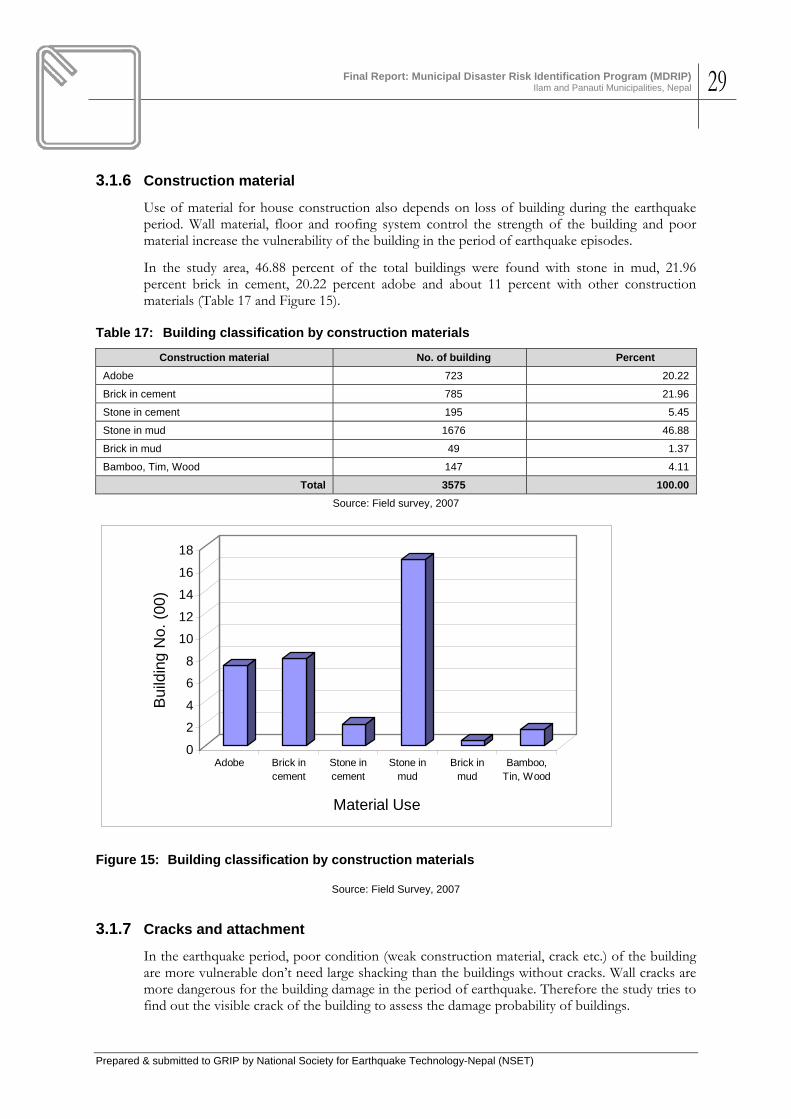
Final Report: Municipal Disaster Risk Identification Program (MDRIP)
Ilam and Panauti Municipalities, Nepal 29
Prepared & submitted to GRIP by National Society for Earthquake Technology-Nepal (NSET)
3.1.6 Construction material
Use of material for house construction also depends on loss of building during the earthquake period. Wall material, floor and roofing system control the strength of the building and poor material increase the vulnerability of the building in the period of earthquake episodes.
In the study area, 46.88 percent of the total buildings were found with stone in mud, 21.96 percent brick in cement, 20.22 percent adobe and about 11 percent with other construction materials (Table 17 and Figure 15).
Table 17: Building classification by construction materials
Construction material No. of building Percent Adobe 723 20.22
Brick in cement 785 21.96
Stone in cement 195 5.45
Stone in mud 1676 46.88
Brick in mud 49 1.37
Bamboo, Tim, Wood 147 4.11
Total 3575 100.00 Source: Field survey, 2007
0
2
4
6
8
10
12
14
16
18
Bui
ldin
g N
o. (0
0)
Adobe Brick incement
Stone incement
Stone inmud
Brick inmud
Bamboo,Tin, Wood
Material Use
Figure 15: Building classification by construction materials
Source: Field Survey, 2007
3.1.7 Cracks and attachment
In the earthquake period, poor condition (weak construction material, crack etc.) of the building are more vulnerable don’t need large shacking than the buildings without cracks. Wall cracks are more dangerous for the building damage in the period of earthquake. Therefore the study tries to find out the visible crack of the building to assess the damage probability of buildings.

Final Report: Municipal Disaster Risk Identification Program (MDRIP)
Ilam and Panauti Municipalities, Nepal 30
Prepared & submitted to GRIP by National Society for Earthquake Technology-Nepal (NSET)
Table 18: Condition of the buildings
Condition No of building Percent Crack 52 1.5
Without crack 3523 98.5
Total 3575 100
Source: Field survey, 2007
In the field study, it was found that 1.5 percent of the total buildings were observed with the wall crack diagonal, horizontal or vertical, which is shown in Table 19 and Figure 16.
05
101520253035
No.
of B
uild
ings
(00)
Crack Without crack
Building Conditions
Figure 16: Condition of the buildings
Source: Field Survey, 2007
Building attachment and separation also play important role for the vulnerability of the building because attached buildings are more vulnerable than separate building. In the study area, it was found that, 6 percent of the total buildings were attached with the other nearest building and about 94 percent were found separate building (Table 19, Figure 17).
Table 19: Attachments of the buildings
Condition No of building Percent Attached 203 5.7
Separate 3372 94.3
Total 3575 100.0 Source: Field Survey, 2007

Final Report: Municipal Disaster Risk Identification Program (MDRIP)
Ilam and Panauti Municipalities, Nepal 31
Prepared & submitted to GRIP by National Society for Earthquake Technology-Nepal (NSET)
05
101520253035
No.
of B
uild
ings
(0
0)
Attached Separate
Attachments
Figure 17: Attachments of the buildings
Source: Field Survey, 2007
3.2 Disaster Risk of Ilam Municipality
3.2.1 Simple Loss Estimation for Scenario Earthquake
The project carried out a simple loss estimation of potential death and injury (day and night) and damage to infrastructure to a Scenario Earthquake. The scenario earthquake was defined based on the knowledge of the geology, and tectonics, including presence of active faults and their characteristics, of an area envelop within 150 km from the municipality. The well known RADIUS Software was used for the loss estimation. RADIUS requires input parameters such as the scenario earthquake, demographic data including distribution of present day population within the municipality in day- and night-time, building inventory and characteristics of the buildings, volume of building construction per year and data on physical infrastructure in the municipality. The loss estimation was repeated for two situations in the conditions: 1) if municipality strictly implements all stipulations of the national building code so that all new buildings are built earthquake-resistant as per the code, and 2) if the current situation of no comprehensive implementation of the building code continues.
The following Table 20 and Table 21 provide the input parameters as well as the results of the simple earthquake loss estimation. Subsequent Figures 18- 25 show the distribution of the intensities of building damage, earthquake-induced casualty (death and injury) in the municipality.
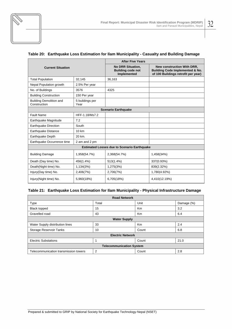
Final Report: Municipal Disaster Risk Identification Program (MDRIP)
Ilam and Panauti Municipalities, Nepal 32
Prepared & submitted to GRIP by National Society for Earthquake Technology-Nepal (NSET)
Table 20: Earthquake Loss Estimation for Ilam Municipality - Casualty and Building Damage
Current Situation
After Five Years No DRR Situation, Building code not
Implemented
New construction With DRR, Building Code Implemented & No. of 100 Buildings retrofit per year)
Total Population 32,145 36,163
Nepal Population growth 2.5% Per year
No. of Buildings 3576 4325
Building Construction 150 Per year
Building Demolition and Construction
5 buildings per Year
Scenario Earthquake Fault Name HFF-1.18/Ms7.2 Earthquake Magnitude 7.2 Earthquake Direction South Earthquake Distance 10 km Earthquake Depth 20 km. Earthquake Occurrence time 2 am and 2 pm
Estimated Losses due to Scenario Earthquake
Building Damage 1,958(54.7%) 2,368(54.7%) 1,458(34%)
Death (Day time) No. 456(1.4%) 513(1.4%) 337(0.93%)
Death(Night time) No. 1,134(3%) 1,275(3%) 839(2.32%)
Injury(Day time) No. 2,406(7%) 2,706(7%) 1,780(4.92%)
Injury(Night time) No. 5,960(18%) 6,705(18%) 4,410(12.19%)
Table 21: Earthquake Loss Estimation for Ilam Municipality - Physical Infrastructure Damage
Road Network Type Total Unit Damage (%)
Black topped 15 Km 3.2
Gravelled road 43 Km 6.4
Water Supply Water Supply distribution lines 33 Km 2.4
Storage Reservoir Tanks 10 Count 6.8
Electric Network Electric Substations 1 Count 21.0
Telecommunication System Telecommunication transmission towers 2 Count 2.8
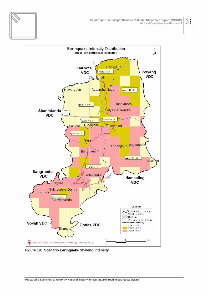
Final Report: Municipal Disaster Risk Identification Program (MDRIP)
Ilam and Panauti Municipalities, Nepal 33
Prepared & submitted to GRIP by National Society for Earthquake Technology-Nepal (NSET)
Figure 18: Scenario Earthquake Shaking Intensity

Final Report: Municipal Disaster Risk Identification Program (MDRIP)
Ilam and Panauti Municipalities, Nepal 34
Prepared & submitted to GRIP by National Society for Earthquake Technology-Nepal (NSET)
Figure 19: Distribution of Building Damage due to Scenario Earthquake in Ilam

Final Report: Municipal Disaster Risk Identification Program (MDRIP)
Ilam and Panauti Municipalities, Nepal 35
Prepared & submitted to GRIP by National Society for Earthquake Technology-Nepal (NSET)
Figure 20: Death due to Scenario Earthquake in Ilam Day time)

Final Report: Municipal Disaster Risk Identification Program (MDRIP)
Ilam and Panauti Municipalities, Nepal 36
Prepared & submitted to GRIP by National Society for Earthquake Technology-Nepal (NSET)
Figure 21: Death due to Scenario Earthquake in Ilam (Night time)

Final Report: Municipal Disaster Risk Identification Program (MDRIP)
Ilam and Panauti Municipalities, Nepal 37
Prepared & submitted to GRIP by National Society for Earthquake Technology-Nepal (NSET)
Figure 22: Injury due to Scenario Earthquake in Ilam (Night time)
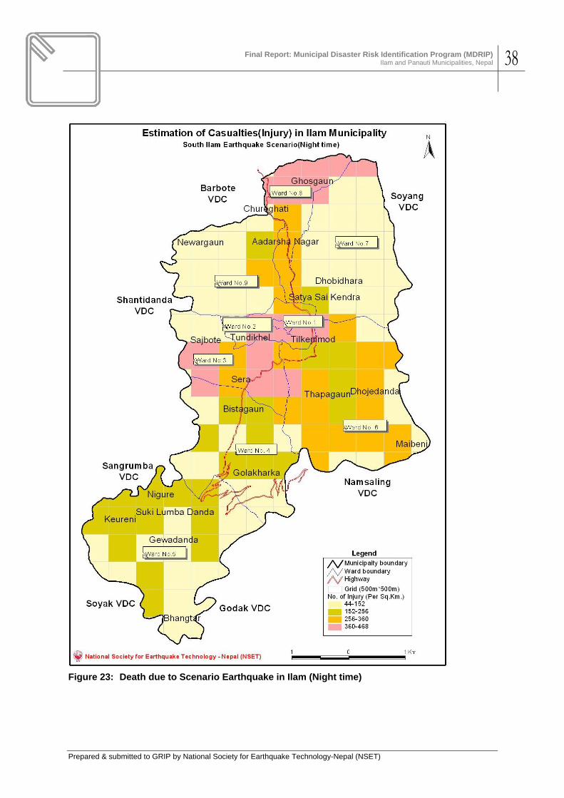
Final Report: Municipal Disaster Risk Identification Program (MDRIP)
Ilam and Panauti Municipalities, Nepal 38
Prepared & submitted to GRIP by National Society for Earthquake Technology-Nepal (NSET)
Figure 23: Death due to Scenario Earthquake in Ilam (Night time)

Final Report: Municipal Disaster Risk Identification Program (MDRIP)
Ilam and Panauti Municipalities, Nepal 39
Prepared & submitted to GRIP by National Society for Earthquake Technology-Nepal (NSET)
Figure 24: Injury due to Scenario Earthquake in Ilam (Day time)

Final Report: Municipal Disaster Risk Identification Program (MDRIP)
Ilam and Panauti Municipalities, Nepal 40
Prepared & submitted to GRIP by National Society for Earthquake Technology-Nepal (NSET)
Figure 25: Injury due to Scenario Earthquake in Ilam (Day time)
Source: Field Survey, 2007
3.2.2 Risk due to Other Hazards
Table 22 lists municipal areas that are considered prone to the Fire, landslide and flood hazards, projected population potentially affected, nearby save haven, and preparedness/mitigation measures. These areas and information were revealed by the process of community watching, DIG, and previous experiences including field survey by the team members. The numbers should be considered approximate. Figure 26 is a hazard map for hazards other than earthquake.
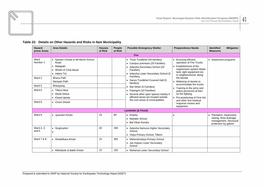
Final Report: Municipal Disaster Risk Identification Program (MDRIP)
Ilam and Panauti Municipalities, Nepal 41
Prepared & submitted to GRIP by National Society for Earthquake Technology-Nepal (NSET)
Table 22: Details on Other Hazards and Risks in Ilam Municipality
Hazard-prone Areas
Area Details Houses at Risk
People at Risk
Possible Emergency Shelter Preparedness Needs Identified Mitigation Measures
Fire Ward Number 1
• Naveen Chowk to Mt Mechi School Road
• Malapath • Whole of Chok Bazar • Hakim Tol
• Thulo Tundikhel (50 families) • Campus premises (25 Families) • Adarsha Secondary School (20
Families) • Adarsha Lower Secondary School (5
Families) • Sanoo Tundikhel Covered Hall (5
families) • Mai Sthan (5 Families) • Patangini (10 Families) • Several other open spaces nearby if
affected areas are located outside the core areas of municipalities
• Ensuring efficient operation of Fire Trucks
• Establishment of fire suppression system Water tank, light equipment etc in neighbourhood, along the bazaar
• Widening of streets to accommodate fire trucks
• Training to the army and police personnel at Ilam on fire fighting
• Pre-positioning of First Aid and other first medical response means and equipment
• Awareness programs
Ward 2 Bhanu Path Narayan Path
Ward 5 Bhanjyang
Ward 6 • Tilkeni Mod • Dhobi Dhara • Kharel danda
Ward 8 • Chure Ghanti
Landslide (& Flood) Ward 6 • Jyaunkiri Kholsi 15 80 • Kharka
• Mahabir School • Bal Vikas Kendra
• • Plantation, Awareness raising, Area drainage management, Structural protection by gabion
Ward 2, 3, and 6
• Singhvahini •
20 400 • Adarsha Namuna Higher Secondary School
• Vidya Primary School, Tilkeni
Ward 7 & 8 • Dhobidhara Kholsi 15 300 • Mahendrodaya Primary School • Jan Kalyan Lower Secondary
School
• Ritthabote & Bakle Kholsi 15 100 • Mahamai Lower Secondary School

Final Report: Municipal Disaster Risk Identification Program (MDRIP)
Ilam and Panauti Municipalities, Nepal 42
Prepared & submitted to GRIP by National Society for Earthquake Technology-Nepal (NSET)
Figure 26: Hazards in Ilam Municipality
The above map was prepared during the PVA survey.
3.3 Disaster Risk of Panauti Municipality
3.3.1 Simple Loss Estimation for Scenario Earthquake
Building inventory of Panauti municipality and the earthquake damage estimation was conducted in the same way as with Ilam Municipality. The following Table 23 and Table 24 provide the input parameters as well as the results of the simple earthquake loss estimation. Subsequent maps show the distribution of the intensities of building damage, earthquake-induced casualty (day- and night-time death and injury) estimated for the municipality due to the occurrence of the scenario earthquake. Figure 27 to Figure 32 show the distribution within the municipal area the impacts of scenario earthquake in terms of distribution of earthquake impacts in terms of intensity, building damage, death and injury at night or day-time earthquake etc.

Final Report: Municipal Disaster Risk Identification Program (MDRIP)
Ilam and Panauti Municipalities, Nepal 43
Prepared & submitted to GRIP by National Society for Earthquake Technology-Nepal (NSET)
Table 23: Earthquake Loss Estimation for Panauti Municipality - Casualty and Building Damage
Current Situation
After Five Years
No DRR Situation, Building code not
Implemented
New construction With DRR, Building Code Implemented
& No. of 100 Buildings retrofit per year)
Total Population 25,563 28,502
Nepal Population growth 2.3 % per year
No. of Buildings 5134 5734
Building Construction 120 Per year
Building Demolition and Construction 20 buildings Per Year
Scenario Earthquake
Fault Name MCT-3.3/Ms7.6 Earthquake Magnitude 7.6 Earthquake Direction North Earthquake Distance 20 km. Earthquake Depth 20 km Earthquake Occurrence time 2 am and 2 pm
Estimated Losses due to Scenario Earthquake Building Damage 1,940(37.8%) 2,167(37.8%) 1,440(25.11%)
Death (Day time) No. 141(0.42%) 157(0.42%) 104(0.36%)
Death(Night time) No. 321(1%) 357(1%) 238(0.83%)
Injury(Day time) No. 1,219(4%) 1,359(4%) 902(3.16%)
Injury(Night time) No. 2,655(10%) 2,960(10%) 1,965(7%)
Table 24: Earthquake Loss Estimation for Panauti Municipality - Physical Infrastructure Damage
Road Network Type Total Unit Damage (%)
Black topped 19.08 Km 2.1
Gravelled road 21.19 Km 3.6
RCC bridge 17 Count 6.9
Water Supply Water Supply distribution lines 1 Km 1.3
Storage Reservoir Tanks 1 Count 5.2
Electric Network Electric Substations 1 Count 14.8
Telecommunication System Telecommunication transmission towers 2 Count 2.0
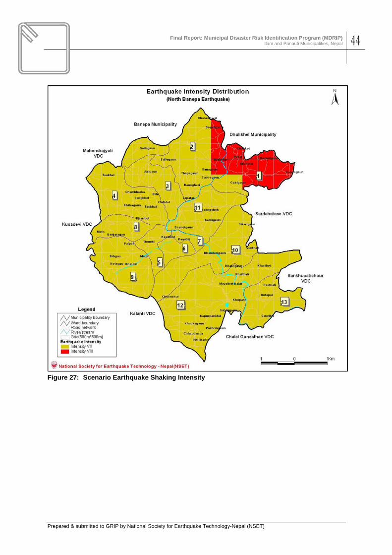
Final Report: Municipal Disaster Risk Identification Program (MDRIP)
Ilam and Panauti Municipalities, Nepal 44
Prepared & submitted to GRIP by National Society for Earthquake Technology-Nepal (NSET)
Figure 27: Scenario Earthquake Shaking Intensity

Final Report: Municipal Disaster Risk Identification Program (MDRIP)
Ilam and Panauti Municipalities, Nepal 45
Prepared & submitted to GRIP by National Society for Earthquake Technology-Nepal (NSET)
Figure 28: Distribution of Building Damage due to Scenario Earthquake in Panauti

Final Report: Municipal Disaster Risk Identification Program (MDRIP)
Ilam and Panauti Municipalities, Nepal 46
Prepared & submitted to GRIP by National Society for Earthquake Technology-Nepal (NSET)
Figure 29: Death due to Scenario Earthquake in Panauti (Day time)

Final Report: Municipal Disaster Risk Identification Program (MDRIP)
Ilam and Panauti Municipalities, Nepal 47
Prepared & submitted to GRIP by National Society for Earthquake Technology-Nepal (NSET)
Figure 30: Death due to Scenario Earthquake in Panauti (Night time)

Final Report: Municipal Disaster Risk Identification Program (MDRIP)
Ilam and Panauti Municipalities, Nepal 48
Prepared & submitted to GRIP by National Society for Earthquake Technology-Nepal (NSET)
Figure 31: Injury due to Scenario Earthquake in Panauti (Day time)
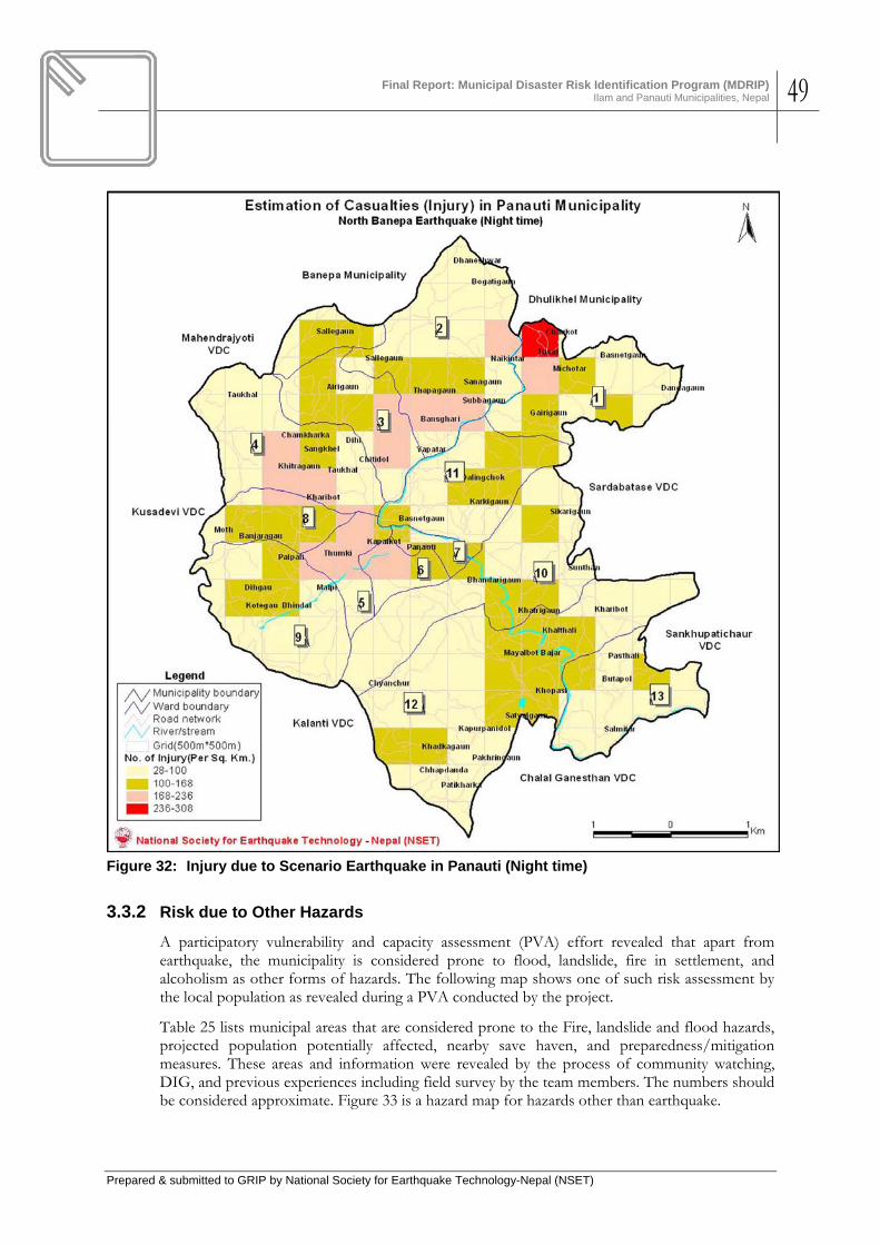
Final Report: Municipal Disaster Risk Identification Program (MDRIP)
Ilam and Panauti Municipalities, Nepal 49
Prepared & submitted to GRIP by National Society for Earthquake Technology-Nepal (NSET)
Figure 32: Injury due to Scenario Earthquake in Panauti (Night time)
3.3.2 Risk due to Other Hazards
A participatory vulnerability and capacity assessment (PVA) effort revealed that apart from earthquake, the municipality is considered prone to flood, landslide, fire in settlement, and alcoholism as other forms of hazards. The following map shows one of such risk assessment by the local population as revealed during a PVA conducted by the project.
Table 25 lists municipal areas that are considered prone to the Fire, landslide and flood hazards, projected population potentially affected, nearby save haven, and preparedness/mitigation measures. These areas and information were revealed by the process of community watching, DIG, and previous experiences including field survey by the team members. The numbers should be considered approximate. Figure 33 is a hazard map for hazards other than earthquake.

Final Report: Municipal Disaster Risk Identification Program (MDRIP)
Ilam and Panauti Municipalities, Nepal 50
Prepared & submitted to GRIP by National Society for Earthquake Technology-Nepal (NSET)
Figure 33: Participatory Hazard Risk Assessment in Panauti Municipality
Source: Participatory Hazard Assessment, 2008

Final Report: Municipal Disaster Risk Identification Program (MDRIP)
Ilam and Panauti Municipalities, Nepal 51
Prepared & submitted to GRIP by National Society for Earthquake Technology-Nepal (NSET)
Table 25: Details on Other Hazards and Risks in Panauti Municipality
Hazard-prone Areas Area Details
Houses at Risk
People at Risk
Possible Emergency Shelter Preparedness Needs
Identified Mitigation Measures
Earthquake Whole Municipality
• Bhimsen Danda, Sharada Lower Secondary School • Naikitar Leather Factory, Ward Office • Balodhhar Lower Secondary School, Ward Office,
Painyutar, Salle area • Cham Khark School, Sankhel School, Bhagwan
Danda, Community Building • Shree Indreshwor Higher Secondary School • Kath Ganesh • Laeku • Bhaleshwor Secondary School • Kamala Primary School, Sharada Secondary School • Gorakhnath Primary School, Technical School,
Bhairab Primary School • Shree Ram Primary School, Satyal Danda • Salmitar Chaur, Bal Adarsha Lower Secondary
School, Kali Devi Temple
• Awareness programs • Training programs on earthquake-
resistant construction to technicians • Orientation to house-owners on
earthquake-resistant construction • Ensuring all new construction
earthquake by following the National Building Code
• Proper urban development and land use planning
Landslide (& Flood)
• Rosi Khola • Punya Mata Khola • Bansdol Kholsa • Khola in Banjaragaon
• Siran Chaur • Ganesh Stan, • Open ground in Satyal Chaur • Open ground in Salmitar • Land occupied by Khopasi Hydroelectric Plant
• Awareness programs • Plantation • Disaster risk sensitive Land Use
planning • River control by Gabion • Control of unauthorized tree-felling
Hail Storm / Frost All 13 wards of Panauti Municipality. While hailstorm destroys plants, floriculture and horticulture, frost exacerbates difficulties of Asthma patients and affects children
• Warm clothing • Awareness raising • Early warning and education • Switching off of electric transformers
during hailstorm • Monitoring of compliance

Final Report: Municipal Disaster Risk Identification Program (MDRIP)
Ilam and Panauti Municipalities, Nepal 52
Prepared & submitted to GRIP by National Society for Earthquake Technology-Nepal (NSET)
Hazard-prone Areas Area Details
Houses at Risk
People at Risk
Possible Emergency Shelter Preparedness Needs
Identified Mitigation Measures
• Development of green belts around horticulture/floriculture
• Protection of plants by mulch and other materials
Fire Different places: • Tushal (Brewery area, Gairi Gaon
Forest • Naya Katar (Plywood factory, Furniture
factory at Bansghari) • Petrol Stations (2) at Thado Bato,
Dudhmel • Chamkhark (Raksiban, Taukhal, Jyala
Jyati Furniture) • Different mills and factories • Different forests
42 (+50 injury)
400 • Khet Ganesh • Leather Factory and Pati, School, Ward Offices • Balouddhar Lower Secondary School • Chamkhark School, Jyalapati, Bhagwan Danda • Siran Chaur, Manteshwory, Indreshwor Hgher
Secondary School • Kath Ganeshthan, Nathe Chaur, Om Danda, Dale
Chaur, Gurans Chaur, Saraswati Kunj, Satyal Danda, Salmetar Chaur, Kali Devi, Bhandari Gaon

Final Report: Municipal Disaster Risk Identification Program (MDRIP)
Ilam and Panauti Municipalities, Nepal 53
Prepared & submitted to GRIP by National Society for Earthquake Technology-Nepal (NSET)
4. DISASTER RISK MANAGEMENT ACTION PLANNING
4.1 Plan Creators
Municipalities created this action plan for disaster risk reduction based on the understanding of the need to protect the population from identified hazards and reduce the associated risks. Representatives of other district level offices of the central government agencies also participated in the process providing coordination between the central and district level infrastructure and economic development plans and the disaster reduction action plans of the municipalities. Other stakeholders, such as the local residences, represented by the social leaders, civil society representatives, leaders of the different political parties, businesses, and other private sectors including academia also participated. Annex 4 and 5 provide the list of attendees to the action planning workshops held in Ilam and Panauti.
4.2 Planning Process
4.2.1 Plan Objectives Definition
The following were accepted as the broad objectives of the Action Plans in both the municipalities.
A. Enhance disaster awareness of common people
B. Capacity Building by conducting training of different stakeholders
C. Effective implementation of National Building Code for improving seismic resistance of new constructions
D. Enhance disaster safety of schools by implementing school disaster safety programs
E. Enhance Emergency response capacities of the municipalities.
4.2.2 Long List of Disaster Reduction Initiatives
NSET collected and discussed a long list of disaster reduction initiatives suitable for Ilam based upon the findings of the loss estimation and potential impact to the municipalities from scenario earthquakes and other identified hazards in the scenario and action planning workshops. The long list was prepared based also on brainstorming sessions and interviews conducted formally and non-formally, including the discussions that were held with the stakeholders in the respective municipalities.
Annex 4 and 5 provide the long lists of disaster reduction initiatives that were discussed in the action planning workshops in the two municipalities respectively.
4.2.3 Priorities criteria
While the above-mentioned objectives were considered as the ruling prerequisites for preparing the long-list of actions, the following criteria were additionally accepted for selection of the initiatives that should go into the action plan.
• Initiatives should be implementable with local/internal resources of the municipalities

Final Report: Municipal Disaster Risk Identification Program (MDRIP)
Ilam and Panauti Municipalities, Nepal 54
Prepared & submitted to GRIP by National Society for Earthquake Technology-Nepal (NSET)
• Ease in implementation – municipality should be confident in implementation potential of the initiative
• Cost effectiveness
• Agencies responsible for the implementation should be interested and find the action implementable
• Interest of the implementation agencies
• Consensus initiatives only
The workshop first approved these criteria before embarking upon selection of the action plan initiatives.
4.3 Disaster Risk Reduction Action Plan for Ilam Municipality
4.3.1 Priority Initiatives
The following are the priority actions adopted by the Ilam Municipality (Table 26)
Table 26: Priority Actions for Disaster Risk Management: Ilam Municipality
SN Components / Activities Duration Budget
(Nepali Rupees,
NR)
Supporting Institutions
Begin End
1 Institutional Development 1.1
Establish a Disaster Risk Reduction Coordination unit in Ilam Municipality. 15,000.00
District Development Committee (DDC),
District Administration Office (DAO)
NSET District Chapter of Nepal Red Cross society (NRCS)
1.2 Pursue Municipality Council to allocate at; east 5 percent of its annual internal budget for Disaster Risk Reduction and preparedness activities. 10,000.00
1.3 Prepare and finalize Disaster Risk Management and Preparedness formulation and implementation guidelines for the municipality and its wards in line with the local governance act. (The Guideline should also contain the authority, responsibility and constituents of the DRR Committees at municipal and ward levels.) 250,000.00
DDC DAO NSET NRCS
1.4 Conduct Disaster Risk Reduction awareness programs at least one for each Municipality ward. (The participants should comprise of representatives of all walks of life including all the active political parties in the municipality). 50,000.00
1.5 Organise and conduct Ward Assemblies and constitute Ward Level Disaster Risk Management Committees. 150,000.00
Final Report: Municipal Disaster Risk Identification Program (MDRIP)
Ilam and Panauti Municipalities, Nepal 55
Prepared & submitted to GRIP by National Society for Earthquake Technology-Nepal (NSET)
SN Components / Activities Duration Budget
(Nepali Rupees,
NR)
Supporting Institutions
Begin End
2 Capacity Building
2.1 Organise and conduct Community Based Disaster Risk Management Training Program for the DRM Committees. (at least five persons from each ward should be trained on CBDRM). 600,000.00
2.2 Organize Participatory Hazard, Vulnerability Capacity Assessment Training program and produce HVCA Map for the municipality 450,000.00
2.3 Organise and conduct First Aid Training at least one for on each ward so as to produce 24 First Aid Volunteers in each ward. 450,000.00
2.4 Organise and conduct Community Level Light Search and Rescue Training at least one for on each ward so as to produce 24 CLSAR Volunteers in each ward. 15,000.00
2.5 Prepare and finalize Disaster Risk Response plans for each potential disaster. 250,000.00
2.6 Preposition of CLSAR Equipment at least in each ward. 1,000,000.00
3 Building Code Implementation
3.1 Organise a Training Program for all the building design professionals in National Building Code.
Division Office of DUDBC
3.2 Conduct Masons Training Programs on Construction of Earthquake Resistant Buildings.
Division Office of DUDBC
3.3 Conduct awareness programs for the potential house owners on Earthquake Resistant Buildings
NGOs, DUDBC,
3.4 Improve the existing Building Permit System to facilitate implementation of National Building Code.
3.5 Establish a monitoring mechanism with reward and punishment system.
Division Office of DUDBC
4 Awareness Campaigns
4.1 Run Radio Programs on Disaster Risk Reduction
FM Radio Stations
4.2 Celebrate Earthquake Awareness Day every year on 21 August in commemoration with 1988 Udaypur Earthquake
DDC, DAO, District Chamber of commerce and industry
Private Businesses
4.3 Observe Earthquake Safety Day every year
All government offices
All NGOs, CBOs, INGOs
Private Businesses
4.4 Conduct awareness programs to various user groups, local clubs and other institutions
All NGOs, CBOs, INGOs
Final Report: Municipal Disaster Risk Identification Program (MDRIP)
Ilam and Panauti Municipalities, Nepal 56
Prepared & submitted to GRIP by National Society for Earthquake Technology-Nepal (NSET)
4.3.2 Other Long Term Disaster Risk Reduction Initiatives: Ilam Municipality
Ilam Municipality has listed other disaster reduction initiatives that it considers appropriate for implementation but these initiatives are not considered as a priority. The municipality will however, endorse if any stakeholder would like to implement these initiatives using their own resources or mobilizing external resources for the same. These initiatives are provided in Annex 4.
4.4 Disaster Risk Reduction Action Plan for Panauti Municipality
4.4.1 Priority Initiatives
The following Table 27 lists the short-term and immediate-start actions that Panauti Municipality accepted as the priority initiatives for disaster risk management in the municipality. The full version of what is called the “Municipal Action Plan for Disaster Management for Panauti” appears in Annex 5.
Table 27: Priority Actions for Disaster Risk Management: Panauti Municipality
SN Components / Activities Duration Lead
Organization Supporting Organization
Start End A Earthquake Risk Management
1 Improve Seismic Performance of New Buildings: Implementation of Building Code
1.1
Incorporate Building Code into Building permit process
May 2009
May 2012
Planning section of Municipality, DE-DUDBC
Municipality, Wards, DUDBC
1.2 Model construction of earthquake resistant building
July 2009
June 2010
DDC, Consumers Group, Local organizations
2 Capacity Building and Earthquake awareness
2.1 Mason training on construction of earthquake resistant building
June 2009
Nov 2013
NSET Local masons
2.2 Community Training on earthquake preparedness including First Aid, Light Search & Rescue, prepositioning
September 2009
March 2010
Training officers from NSET
Local committee members
2.3 Art competition 4 per year
Municipality, NSET, Schools
2.4
Production & Dissemination of Awareness material
Aug 2009
Sep 2012
Municipality, schools, public health institutions
2.5 Earthquake awareness rally Jan 16
every year
School, municipality, clubs, Red Cross
3 Earthquake Preparedness
3.1 Managing materials and equipments for first aid and community level search & rescue tasks
2009 2012 Municipality Health posts, Police, Army, Red Cross, Municipality,
3.2 Formation of Disaster Management Committees at Ward Levels
April 2009
March 2011
Municipality/Wards
Local population, CBOs, NGOs
3.3 Develop strategies for Post disaster Immediate settlement and reconstruction of damage buildings
Immediate
Municipality CDO, NGOs, NRCS, Nepal Scout
B Landslide and Flood Risk Management
Final Report: Municipal Disaster Risk Identification Program (MDRIP)
Ilam and Panauti Municipalities, Nepal 57
Prepared & submitted to GRIP by National Society for Earthquake Technology-Nepal (NSET)
SN Components / Activities Duration Lead
Organization Supporting Organization
Start End 1 Landslide and Flood Hazard Assessment
1.1 Inventory of areas affected by landslide and floods by undertaking field visits.
April 2008
May 2009
Concerned wards
District office of landslides, other agencies
1.2 Interaction with stakeholders Information collection from prone areas
June 2009
Planning section
Stakeholders, ward, media
1.4 Field mapping of landslide and flood prone areas and preparation of hazard and risk maps
July 2009
Aug 2009
Planning section, Municipality
Concerned wards, District landslide office
2 Public awareness
2.1 Orientation, Discussions (workshops) and interactions on probable disasters
June 2009
Nov 2009
Planning section- Municipality
NSET
2.3 Public awareness campaign using Newspaper/ Hoarding boards, and Radio programs
Municipality Print and electronic media including FM radio stations
3 Hazard Mitigation Measures
3.1
Implement protective plantation along river banks and steep terrain, undertake conservation of protective plants including regular maintenance
June 2009
June 2009
District forest office
Users’ groups
3.3 Carry out terrace improvement in inclined lands
Oct 2009
Feb 2010
District Users’ groups
4 Define stream bed and banks in maps (Determining standards for rivers and streamlets)
4.1 Identifying areas of flow as per maps for the narrowed ones
Nov 2009
Jan 2010
Planning section-Municipality
5 Conservation of structures
5.1 Cleaning & repair-maintenance of irrigation canals
Feb 2010
May 2010
Municipality Users’ groups
5.2 Repair-maintenance & new construction of check dams, support walls
Aug 2010
Dec 2010
DWIDP Municipality
C Epidemics Risk Management
1 Reduction of Cholera Outbreak Risk by managing Drinking Water
1.1 Cleaning the source springs April 1, 2009
continuously
Concerned users’ group
Municipality, Water supply corporation
1.2
Construction and repair of water tank and water treatment, with regular Laboratory tests
May 1, 2009
May 15, 2009
Concerned users’ group, Public Health Office
Municipality, Water supply corporation, DDC
Prepositioning of emergency / evacuation kits consisting of stretchers, first aid kits etc
June 2009
Nov 2009
Red Cross
Toilet construction Mar
2009 2012 Concerned
users’ group Municipality,
2 Training and Capacity Building
2.1 Conduction training programs of Hygiene and sanitation
Mar 15, 2009
June 2009
Community Public health office, municipality
3 Awareness programs
3.1
Information dissemination from FM radios Mar-July every year
continuously
Municipality, District health office

Final Report: Municipal Disaster Risk Identification Program (MDRIP)
Ilam and Panauti Municipalities, Nepal 58
Prepared & submitted to GRIP by National Society for Earthquake Technology-Nepal (NSET)
5. IMPACT AND LESSONS LEARNED
5.1 The Initial Impacts
MDRIP approach combined activities related to project planning, awareness raising and several other activities such as community risk identification (using Disaster Imagination Game (DIG), PVA, etc) to be run in parallel. This approached proved its purpose – DIG method of hazard hunt very much impressed at the very start of the project and immediately got the buy-in of the people. One of the best examples was immediate action to proper relocation within a week of a highly hazardous situation of the un-insulated high voltage transmission line passing through the veranda of buildings as seen in the first photograph on the right. The house owner has placed a horizontal timber post to take the bare cable away from the building. An extra electrical pole was installed to reduce the risk. This situation was very much discussed during the DIG.
Figure 34: House is Safer due to Erection of a New Pole
Figure 35: A new building with incorporation of earthquake-resistant elements learnt from
MDRIP training

Final Report: Municipal Disaster Risk Identification Program (MDRIP)
Ilam and Panauti Municipalities, Nepal 59
Prepared & submitted to GRIP by National Society for Earthquake Technology-Nepal (NSET)
The most important initial impact of MDRIP at the institutional level has been the implementation of National Building Code in Ilam. There are now a few private buildings which have incorporated one or the other earthquake resistant components in their building. For instance the photograph on the right has a horizontal band to tie the infill wall in between the columns as suggested by the building code. The reinforcement bars left for the lapping has also considerably increased to elongate lap length as per the requirement.
Similar encouraging initial impacts can also be seen in Panauti, The municipality has begun the process by deciding to make the necessary preparation of implementing National Building code so that it can start the implementation from the coming fiscal year. The municipality is planning to construct two earthquake resistant model buildings in the Municipality. The municipality is in the process of revising the design of a community building to convert it into the first earthquake resistant model building in the municipality. The building will be constructed this year.
Panauti municipality has also taken initiation to train more masons on construction of earthquake resistant buildings so that it can implement the National Building Code progressively better by incorporating the code stipulations into the building permit process.
Both the municipalities have set aside a small fund for this fiscal year to continue the intervention initiated during MDRIP.
5.2 Lessons learned
The following are the lessons learned from the implementation of MDRIP using the approaches and methodologies adopted.
1. It is necessary to work with Local Government: MDRIP gave a boost to the municipal effort towards building code implementation. Although implementation of the national building code has been declared as mandatory for municipalities of Nepal, both the municipalities did not have much idea about the modus operandi of building code implementation. They did not have proper strategy, and hence confidence, of conforming to the central government’s decree. The MDRP process explained the detailed requirements of building code implementation by incorporating it into the building permit process, showed the need for capacity enhancement, both of the municipal organization, and also of the municipal as well as private engineers and technicians. At the same time, the municipality as well as the people and also the technical personnel were convinced on the technical as well as economic feasibility of seismic resistant design and construction of the residences and office building. Although full impact of the building code implementation would be seen and felt in years to come, there has been a significant change in the mind set of people as well as of the authorities and the technicians on the need and possibility of code compliance.
2. Explaining complex concepts of earthquake safety (structural and non-structural) in a simple language pays: Usually, people do not know what to ask for with the disaster managers and the disaster managers do not know what and how to advice the people because of low level of knowledge and awareness with both. MDRIP, apart from conducting hazard and risk assessment, also provided opportunities for everyone to learn things in simple language. Every day of the field work in the municipalities was a learning day for all: the municipal officials and technicians learned the complicated processes of earthquake disaster risk reduction while the project team members learned on the best method of approaching and transmitting and internalization of the knowledge.
3. Combination of Local wisdom and modern knowledge in Disaster Risk Management is a must for Effective Risk Assessment and Reduction: PVA process helped identify

Final Report: Municipal Disaster Risk Identification Program (MDRIP)
Ilam and Panauti Municipalities, Nepal 60
Prepared & submitted to GRIP by National Society for Earthquake Technology-Nepal (NSET)
the existing situation on hazards and vulnerability, and also several possible counter-measures for disaster reduction. This helped much in identification of the level and types of risks and the corresponding mitigation measures. That provided the required foundation not only for effective action planning but also ownership of the risk assessment and action planning process and results by the communities and residents. While disaster risk reduction is a long-term and challenging task, however, respect of local wisdom and local indigenous technologies creates better psychological environment for DRR.
4. Transparency brings interest, involvement and ownership: Implementation of the project under condition of a lack of elected representatives to the municipal and ward councils could be achieved due to the transparent and all-inclusive approaches adopted in all activities of the project including its financial aspects. Everybody involved in the process were given opportunities for voicing their concerns at any time of the field works including during the awareness raising, training and workshop programs. Presence of representatives of all political parties and government offices together with those of the academia and civil society and private businesses could help propagate the message that disaster risk reduction is a task that transgresses all political of social difference.
5. Urban disaster risk identification Methodology is cost efficient and replicable: NSET experience from yester years resulting in the approaches and methodology employed was appreciated in both the municipalities by people of all walks of life. For NSET, the biggest achievement was that all stakeholders in both the municipalities have been exposed to new methods of DRR, their awareness level heightened, and interest generated to the extent that both municipalities started visualising more roles for themselves and lesser with time role for NSET, as seen in the action plans. While NSET needs to continue providing technical support to the municipalities at their request, all the technical agencies, especially the government and local non-government organizations have been empowered with knowledge and methods of risk identification and mitigation.
6. Urban Disaster Risk Atlas of Nepal can be prepared within a few years time: NSET strongly believes that the remaining municipalities of Nepal can produce their own hazard risk maps and action plans to manage the risks if NSET continues providing technical assistance to the municipalities in the same way as was done in this phase of MDRIP. The entire program was cost-effective.
7. It is absolutely necessary for International Agencies/initiatives such as UNDP/GRIP to develop RADIUS-type tools of risk assessment for Flood, Landslide and fire: simplicity of the tool is a vital characteristic.

Final Report: Municipal Disaster Risk Identification Program (MDRIP)
Ilam and Panauti Municipalities, Nepal 61
Prepared & submitted to GRIP by National Society for Earthquake Technology-Nepal (NSET)
6. CONCLUSIONS & NEXT STEPS
6.1 Conclusions
Municipal Level Disaster Risk Reduction in Nepal (MDRIP) was the first intervention in the field of Disaster Risk Reduction at the Municipal Level in both the municipalities. MDRIP activities have been very much useful in stimulating the municipalities to take initiate Disaster Risk Reduction activities. Both the municipalities as well as the line agencies in the respective districts along with the people have participated actively in the planned activities. This resulted in a smooth run for all the activities planned even during the fragile political scenario with so many “bandhs” and “strikes” though the duration had to be extended by three months. Both the municipalities have very well initiated the process of Disaster Risk Reduction at the Municipal Level. This initiation can be considered to the green signal in the municipalities for such interventions and need more support in the future. This first initiation is not enough for them and needs more activities to be done to make the endeavour much effective and sustainable. Obviously we can not continue with a never ending endeavours but it would be very much appropriate to plan a second phase of the intervention with a set of participatory activities and planned exit strategy so that the municipalities can continue on their own in the field of Disaster Risk Reduction.
6.2 Recommendations
The following are the recommendations that naturally and logically crops up from the project implementation. • The disaster risk assessment and action planning for disaster risk management works
conducted in the municipalities should be considered as the start of a long-term process of disaster risk reduction in the project municipalities. The action plans need to be implemented and updated. Moreover, with further urban development the need for much more detail level of risk assessment and characterisation will grow. So all the process, and the plan implementation should be continued. The plans should be widely publicised to get wider ownership and conformation. Nepal has prepared a National Strategy for Disaster risk Management (NSDRM) which emphasizes on implementation of DRR priority actions in district and municipal (local) levels with a two-pronged strategy: a) implement stand-alone actions and b) incorporate DRR into development planning and implementation. The municipality should adhere to these principles and try to link the Action Plans to the NSDRM.
• Capacity Building: This should be one of the priority actions: engineers and all technical personnel in the municipalities, the designers, the contractors’ technical personnel, the manufacturers of construction materials and the traders – all should be trained appropriately for doing what they are currently doing in a better way. The municipalities as well as the district level agencies of central government institutions such as the DUDBC, Forest and watershed management department, Nepal Electricity Authority (NEA), District Hospitals and all others should incorporate DRR into their annual plans and allocate appropriate budget. DRR is not something that could be postponed for future, one has to start now, because MDRIP has created the necessary warm-up and also because the national policy demands it. The all-accepted global strategy of disaster safety: a) stop increasing further disaster risk by ensuring incorporation of DRR into development planning and works, b) Reduce existing risks by mitigation measure implemented through stand-alone projects or initiatives, and c0 prepare for residual risk – should be followed.

Final Report: Municipal Disaster Risk Identification Program (MDRIP)
Ilam and Panauti Municipalities, Nepal 62
Prepared & submitted to GRIP by National Society for Earthquake Technology-Nepal (NSET)
• NSET still has to hold hand and provide technical assistance as indicated in the Action Plans of the two municipalities. NSET should be supported by international agencies and donors for it to be able to provide the assistance required,
• Second Phase of MDRIP should be started as soon as possible in Nepal. NSET has accepted to implement the Urban Disaster Risk Atlas Project in Nepal as a part of its MERMP. This project will continue the method of working closely with the municipalities with the aim of empowering them. NSET invites international agencies to assist NSET in undertaking these tasks. We hope very much that GRIP/UNDP will continue providing financial support.
• We recommend GRIP to manage to develop tools for disaster risk assessment similar to RADIUS also for flood and landslide as soon as possible.

Final Report: Municipal Disaster Risk Identification Program (MDRIP)
Ilam and Panauti Municipalities, Nepal 63
Prepared & submitted to GRIP by National Society for Earthquake Technology-Nepal (NSET)
7. REFERENCES Chamlagain, Deepak and Vishnu Dangol, 2002, Landslide Hazard evaluation in and around the Ilam Hydropower Project, Eastern Nepal Himalaya: journal of Nepal Geological Society, 2002, vol. 27 ( Special Issue). PP 131-143. CBS (1996). Nepal Living Standards Survey 1995/96: Statistical Report (Volume 1 and Volume 2). Kathmandu: Central Bureau of Statistics, His Majesty's Government of Nepal. CBS (2002). Population Census 2001 [computer data file]. Kathmandu: Central Bureau of Statistics, His Majesty's Government of Nepal. CBS (2004). Nepal Living Standards Survey 2003/2004: Statistical Report (Volume 1 and Volume 2). Kathmandu: Central Bureau of Statistics, His Majesty's Government of Nepal. CBS (2005). Nepal Living Standards Survey 1995/96 and 2003/04 [computer data file]. Kathmandu: Central Bureau of Statistics, His Majesty's Government of Nepal. CBS (2005a). Poverty Trends in Nepal (1995-96 and 2003-04). Kathmandu: Central Bureau of Statistics, National Planning Commission. CBS (2006). Resilience Amidst Conflict: And Assessment of Poverty in Nepal, 2995-96-2003-04.Kathmandu: Central Bureau of Statistics, National Planning Commission. CBS (Central Bureau of Statistics/Government of Nepal), United Nations World Food Programme, Nepal and The World Bank, 2006, Small Area Estimation of Poverty, Caloric Intake and Malnutrition in Nepal, (Kathmandu, CBS/GoN, UN/WFP and WB, 2006) ISBN : 99933-701-8-5 CBS 2007, Population Profile of Nepal 2007. CBS and WFP 2006). Small Area Estimation of Poverty, Caloric Intake and Malnutrition in Nepal. Kathmandu: Central Bureau of Statistics and the United Nations World Food Program. Chettri, D. (2004). Practices of Poverty Measurement and Poverty Profile of Nepal. ERD Working Paper No. 57. Manila: Asian Development Bank. Dixit, A. M., (1996). Disaster Management in Nepal, a Country Paper prepare for UNCHS (HABITAT) and presented to the workshop experiences in disaster management in Asia, November 1996, Kalutara, Srilanka. DWIDP (2006), DWIDP Bulletin F.Y. 2005/2006, DWIDP (Department of Water Induced Disaster Prevention), Ministry of Water Resources, GoN. Page 2. ICIMOD (2007), Disaster Preparedness for Natural Hazards: Current Status in Nepal (a consultancy report by Bhubanesh Kumar Pradhan), Kathmandu, May 2007, ICIMOD Nandalal Khatiwoda, Seismic Vulnerability Of Building A Case Study Of Ilam Municipality, a MS thesis, Central Department of Geography, Tribhuban University, August 2008 NSET (19981), The Kathmandu Valley Earthquake Risk Management Action Plan: A Product of the Kathmandu Valley Earthquake Risk Management Project, Kathmandu. NSET (19982), Earthquake Scenario of Kathmandu Valley: A Product of the Kathmandu Valley Earthquake Risk Management Project, Kathmandu. NSET (2007), Disasters in Nepal: Inventory of Events and Analysis of Impacts (Period Covered 1971-2006), Preliminary Analysis (In–house unpublished report under the DesInventar Project of NSET), National Society for Earthquake Technology – Nepal, Kathmandu.

Final Report: Municipal Disaster Risk Identification Program (MDRIP)
Ilam and Panauti Municipalities, Nepal 64
Prepared & submitted to GRIP by National Society for Earthquake Technology-Nepal (NSET)
NSET (2008), DesInventar Project, an ongoing disaster information management system operated by the National Society for Earthquake Technology – Nepal (NSET), available in www.desinventar.net NSET (2008) National Strategy for Disaster Risk Management in Nepal (Final Draft), submitted to UNDP Nepal by the National Society for Earthquake Technology – Nepal Pradhan B. K. (2007). Disaster Preparedness for Natural Hazards: Current Status in Nepal, Kathmandu: ICIMOD (International Centre for Integrated Mountain Development) UNDP (2007). Human Development Report 2005. New York: United Nations Development Program. UNDP (2008). National Strategy for Disaster Risk Management in Nepal. Government of Nepal. UNDP/UNCHS (Habitat) (1994), Seismic Hazard Mapping and Risk assessment for Nepal, A Report prepared under the Building Code Development Project UNDP/UNCHS (Habitat) Subproject 88/054/21.03, Kathmandu

Final Report: Municipal Disaster Risk Identification Program (MDRIP)
Ilam and Panauti Municipalities, Nepal 65
Prepared & submitted to GRIP by National Society for Earthquake Technology-Nepal (NSET)
ANNEX 1. DETAILS OF WORKS CARRIED OUT
The following text records in logical sequence the seven different major streams of activities conducted in each municipality for the implementation of the MDRIP project.
Activity # 1 Preparatory works at the concerned municipality
Project Initiation Meeting and Agreement
Municipal Disaster Risk Reduction in Nepal (MDRIP) being implemented in Ilam and Panauti Municipalities began with the project initiation meeting in both the municipalities. National Society for Earthquake Technology – Nepal (NSET) signed an agreement with both Ilam and Panauti Municipalities to facilitate the smooth running of the activities planned under MDRIP. The municipalities assigned one of their staff to act as a focal person who will be responsible in coordinating the project activities with the municipality and NSET. Mr. Prem Kumar Sonam an Engineer from Panauti Municipality and Mr. Bhim Prasad Dhungana, Assistant Sub Engineer from Ilam Municipality are assigned for the coordination of MDRIP activities for their respective Municipalities. Both the focal persons are working actively to carry out the activities.
Baseline Survey and Building Inventory
All the basic data required to run the RADIUS program to make a preliminary earthquake risk assessment. Existing building stock its typology and the inhabitants are the major information required to run RADIUS. This information was collected through a base line survey conducted in close coordination with the municipalities. Ilam has 3,576 housing units and the population is 16,246. There are 5,134 dwelling units in Panauti and the population is 14,674.
Building inventory Survey, Panauti
Activity # 2 Risk Assessment
Disaster Imagination Game (DIG) and Vulnerability Tour
Disaster Imagination Game (DIG) and Vulnerability Tour were organized for one day in both the municipalities. This program was organized so that the community members residing in the core city areas would be well aware of the existing hazard risk and vulnerabilities in their

Final Report: Municipal Disaster Risk Identification Program (MDRIP)
Ilam and Panauti Municipalities, Nepal 66
Prepared & submitted to GRIP by National Society for Earthquake Technology-Nepal (NSET)
community. The participants comprised of all works of life from political leaders, teachers, students, businessmen, housewives, local influential persons and professionals. The participants discussed about the potential hazards their consequences and the resources available to cope with the disaster resulting from the hazard. This information was plotted in a map of the core area represented by the participants. This map then was divided into four quadrants so that the participants would go for a vulnerability tour to verify the information they had mapped. To facilitate the vulnerability tour the participants were divided into four groups. Each group went through the core area with the map prepared during DIG and observed their community by verifying the information in the map and improving it with the first hand observations they made. All the four groups shared their findings along with the map in the plenary after the vulnerability tour. After the sharing, potential disasters and existing hazards were finalized and prioritised for the core area of the municipality. Earthquake and Fire was identified as the first and second priority in both the municipality. The third priority of Ilam was Road Accidents where as that of Panauti was identified as Epidemics. 28 persons from each municipality participated actively in the DIG and Vulnerability Tour organised in Ilam and Panauti.
Vulnerability Tour, Panauti Electricity Supply Line Diversion, Ilam
Both the Municipality prepared a Municipal level Hazard Vulnerability Capacity Assessment maps. Then the municipality prioritized the top five potential disasters as the outcome of the Risk Assessment exercise that the project facilitated them to organize.
Participatory Hazard Map of Ilam Participatory Hazard Map of Panauti

Final Report: Municipal Disaster Risk Identification Program (MDRIP)
Ilam and Panauti Municipalities, Nepal 67
Prepared & submitted to GRIP by National Society for Earthquake Technology-Nepal (NSET)
The Potential disasters in Ilam were identified as Earthquake, Fire, Landslide and Floods. Similarly Earthquake, Fire, Landslides and Epidemics was considered to be the top five disasters potential to Panauti
Kick off Meeting and Hazard Mapping Workshop
A one-day Kick off Meeting and Hazard Mapping Workshop was organized in both the municipalities. The participants for the event comprised of the representatives from all the geographic area and kinds of people (races, casts, ethnic groups and professionals) including all the ward secretaries, active representatives from NGO/CBO working within the municipality. Further some district level officials from District Administration Office (DAO), District Development Committee (DDC) Department of Urban Development and Building Construction (DUDBC) and District Police Office (DPO), Nepal Red Cross Society (NRCS) were also invited for the Kick off meeting. 28 persons participated in Ilam and Panauti had a larger participation of 38 persons in this event.
MDRIP Kick off Meeting, Ilam Hazard Mapping Group Work, Panauti
The first half of the day was devoted for opening ceremony and introduction of the project MDRIP. The other half of the day was used for participatory hazard mapping of the entire municipality. The Kick off Meeting started with a brief introduction on the project, its background and the future prospects. Two major presentations were made on the meeting the first one was “Introduction to MDRIP and NSET” and the second was "Municipal Earthquake Risk Management and its Achievements." The presentation also included the initial results of RADIUS in both the municipalities.
The second half of the day was devoted to participatory Hazard Mapping. The workshop began with a concept paper on "Existing Disaster Management in Nepal and its Challenges". After the presentation the participants discussed on various aspects of municipal level disaster risk reduction and prepared a list of potential hazards/disasters for the entire municipality. The list was then prioritised and five most potential disasters were identified. The participants were then divided into four groups so that each group would prepare a hazard map for each of the identified hazards. These maps are now being processed including the required improvement and the final hazard/resource map will be prepared in the near future.
Earthquake risk assessment was done using the tool RADIUS. The tool was discussed with the stakeholders in detail, and people, especially the mayors and technical personnel of the municipalities were involved in running the program. The result of this simple loss estimation has been presented in Chapter 3.

Final Report: Municipal Disaster Risk Identification Program (MDRIP)
Ilam and Panauti Municipalities, Nepal 68
Prepared & submitted to GRIP by National Society for Earthquake Technology-Nepal (NSET)
CDO inaugurating the Workshop, Panauti CEO Panauti Municipality addresses the Workshop
Activity # 3 Municipal Level Risk Reduction and Response Master Plan
Two day Workshops were held at both the municipalities to initiate the process of Disaster Risk Reduction and Response Master Planning process. There was a gathering of all the stake holders from the District and the municipalities. Both the workshops were chaired by the Chief and Executive Officer of the Municipalities, The Chief District Officers were the Chief Guests and the Chief of the concerned line agencies from the district level government offices were among the special guests invited. The outcomes of the Disaster Imagination Game and the Participatory Hazard Vulnerability and Capacity Assessment along with the preliminary result of the RADIUS were presented in the first day of the Scenario and Action Planning Workshops held at both the Municipalities. A set of questionnaire were used to access the existing capacity of the municipality including that of the concerned government line agencies working in the district.
The Disaster Risk Reduction and Response Action Planning process was initiated in the second day of the workshop. Both the municipalities have prepared the list of Disaster Risk Reduction activities identified. For the identification of the actions to be taken the participants of the workshops were divided into various groups so that each group could work in detail for each disaster.
Presentation of the Group Work

Final Report: Municipal Disaster Risk Identification Program (MDRIP)
Ilam and Panauti Municipalities, Nepal 69
Prepared & submitted to GRIP by National Society for Earthquake Technology-Nepal (NSET)
The Scenario and Action Planning workshop has been proved to be a very good opportunity for a healthy interaction in between the people and the municipality authorities and also enhanced the participatory planning process. There was a brief review of the existing rules and regulations pertaining to Municipal Level Disaster Risk Reduction. However a detailed analysis and the necessary steps will be taken in an appropriate time. This is because the municipalities do not have the elected body at the moment.
Activity # 4 Initiate Implementing the Disaster Risk Reduction Initiatives
Develop a mechanism for effective implementation of Nepal National Building Code
Ilam Municipality has declared a phase wise implementation of the Nepal National Building Code (NBC) with effect from July 2008. Panauti Municipality has decided to make all the preparations pertaining to implement NBC during this fiscal year so that it can be implemented from July 2009. Both the Municipalities have requested NSET to provide technical input for the implementation of NBC in their respective municipalities.
Activity # 5 Capacity Building
Training of Engineers
A five day Basic Technical Training (BTT) Course on Design and Construction of Earthquake Resistant Buildings was conducted in Ilam from 25 to 29 August 2008. 23 persons actively participated in the training program conducted in Ilam Municipality.
Engineers' Training Program, Ilam
The participants comprised of Engineers, Sub-Engineers, Assistant Sub-Engineers and Architects working within the municipalities. The participants from Department of Urban Development and Building Construction (DUDBC), District Development Committee (DDC) and Rural Reconstruction Nepal were also included in the program. The curricula comprised of Earthquake Basics, Fundamental Principal of Earthquake Resistant Design and Construction and Concepts of Adult Learning and the Training Process. The objective of the training was to enhance the technical capabilities of the participants and introduce training techniques so that they could work as a vehicle of technology transfer by training the masons.

Final Report: Municipal Disaster Risk Identification Program (MDRIP)
Ilam and Panauti Municipalities, Nepal 70
Prepared & submitted to GRIP by National Society for Earthquake Technology-Nepal (NSET)
Masons Training Program
A five Day Masons Training Program on Construction of Earthquake Resistant Building was organised in both the municipalities. This training program was organized with the objective of upgrading the skill of practicing masons in earthquake resistant construction of building.
Masons' Training Program, Ilam Masons with the certificates pose before the audience of the awareness program
The curricula comprised of optimal theoretical sessions to provide basic concept on Earthquake Risk Mitigation with special focus to structural mitigation measures. Most of the time was devoted for practical works to equip the masons with hands on experience on earthquake resistant components on Load Bearing Masonry Buildings and Framed Structured Buildings. The full scale models of each of these building types prepared by the trainees are permanently kept safe in the Municipality Premises. This will facilitate the municipal engineers to demonstrate and transfer the technology through the potential house owners coming to the municipality for the building permit.
Activity # 6 Community Education and Awareness
A one-day general Awareness Program on Disaster Management and Earthquake Risk Reduction was organized in both the Municipalities. The program was open for participation by all residents. Turnover actually was significant in both the municipalities. The awareness program began with the introductory presentation of MDRIP and its achievement including the preliminary outcome of the RADIUS. After this presentation the distinguished persons present in the event distributed the certificates to the trained masons before the audience. The distribution of the certificates to the trainees was organized on this event so as to honour the masons amidst their potential clients. Relevant videos on earthquake risk reduction including some more presentations were made on this event so as to aware the general public on their role in Community Level Disaster Risk Reduction.
Nepal Vani the Community Radio in Ilam aired several interviews of the participants. It also organized talk programs on Disaster Risk Reduction including Earthquake Risk Mitigation and Preparedness. The local papers also gave important to the event and there was a good coverage of the programs in their respective issues.

Final Report: Municipal Disaster Risk Identification Program (MDRIP)
Ilam and Panauti Municipalities, Nepal 71
Prepared & submitted to GRIP by National Society for Earthquake Technology-Nepal (NSET)
The Shake-Table demonstration was another important event in the dissemination of the effectiveness of the earthquake resistant construction techniques. Two identical models built with the same set of masons using the same building materials were prepared. The only difference in between these two sets was that one of them was built as per the prevailing construction practice where as the other was constructed using earthquake resistant construction techniques as introduced to them in the various training and awareness programs. Both the buildings were placed on top of a vibrating table. The table was then vibrated to demonstrate the effects of an earthquake in the buildings. At every stage of the deformation of the building due to the vibration there was question and answer sessions to brief on the various earthquake resistant components incorporated in the improved building where as the building built with conventional method was deformed at every stage of vibration.
The vibrating process continued till the conventional building came into complete collapse where as the other building was erect with very minimal few hair cracks. The table was then vibrated continuously for another 45 seconds manually to demonstrate the effectiveness of the new technology and still the building sustained only nominal accepted level of damages in the form of hair cracks. This event was also live broadcasted by the local FM Stations. This Shake table demonstration was very much effective in disseminating the technology to more than one thousand persons present in the event.
Models Before Vibration Models after the Vibration
Activity # 7 Model Demonstration of Earthquake Risk Reduction
Ilam Municipality has already initiated National Building Code with the help of the Masons trained on the Construction of Earthquake Resistant Buildings in the municipality. It has a few numbers of private earthquake resistant buildings as the outcome of MDRIP. However all the buildings built after this initiation have not incorporated all the components in their construction but the process has begun and we need to enhance the implementation mechanism as well as a continuous awareness program for this is an essential requirement at the stage. Panauti has decided to make the necessary preparation within the municipality this year so that the National Building Code can be implemented from next fiscal year. There has been a good initiation of the municipality in trying to improve the design of a community building that the municipality is planning to construct this year. The design has been improved and the municipality is pursuing with the community to make it the first earthquake resistant building in Panauti.
��

Final Report: Municipal Disaster Risk Identification Program (MDRIP)
Ilam and Panauti Municipalities, Nepal 72
Prepared & submitted to GRIP by National Society for Earthquake Technology-Nepal (NSET)
ANNEX 2. COPIES OF MEMORANDA OF UNDERSTANDING WITH THE MUNICIPALITIES
A. MOU between Ilam Municipality and NSET

Final Report: Municipal Disaster Risk Identification Program (MDRIP)
Ilam and Panauti Municipalities, Nepal 73
Prepared & submitted to GRIP by National Society for Earthquake Technology-Nepal (NSET)
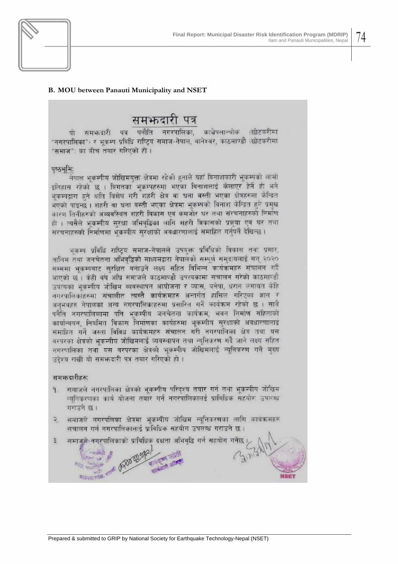
Final Report: Municipal Disaster Risk Identification Program (MDRIP)
Ilam and Panauti Municipalities, Nepal 74
Prepared & submitted to GRIP by National Society for Earthquake Technology-Nepal (NSET)
B. MOU between Panauti Municipality and NSET

Final Report: Municipal Disaster Risk Identification Program (MDRIP)
Ilam and Panauti Municipalities, Nepal 75
Prepared & submitted to GRIP by National Society for Earthquake Technology-Nepal (NSET)

Final Report: Municipal Disaster Risk Identification Program (MDRIP)
Ilam and Panauti Municipalities, Nepal 76
Prepared & submitted to GRIP by National Society for Earthquake Technology-Nepal (NSET)
ANNEX 3. LONG LIST OF INITIATIVES FOR DISASTER RISK REDUCTION ACTION PLANNING – ILAM MUNICIPALITY
Group 1: Raising Public Awareness
Participants: Bhim Prasad Poudel, Rohit Chandra Bhattarai, Jeevan Sharma, Meghnath Dhungana, Diwakar Bhandari, Sharmila Sharma, Ram Kumar Shah, Gita Bishwakarma
SN Activity Duration Participating Institutions Estimated Budget Main Supporting
1 Awareness Program for 114 Locality (Tole) Development Organizations
2 times/ year Municipality NSET
2 Information dissemination from newspapers/ Broadcasting programs from local FM Radios
Weekly NSET Municipality/ Media
3 School Education Programs District Education Office/ Schools
4 Orientation programs to members of cooperative organizations
1 time/ year Concerned cooperative organizations
NSET, Municipality
5 Street Drama Red Cross, Municipality
NSET
6 Training to masons -25 nos. Municipality NSET, DUDBC
7 Public Campaigns Red Cross NSET, DUDBC
8 Awareness programs to construction entrepreneurs
Construction Association of Nepal
Municipality, NSET
9 Posters, Pamphlets, Hoarding Boards, Documentary production and dissemination
Municipality
10 Earthquake Safety Day Municipality Red Cross and others
11 Prizes on ESD Municipality NSET
12 Awareness program to members of community forest Group
Municipality Concerned groups. NSET
Group 2: Establishment & Development of Municipality-level Disaster Management Mechanism
Participants: Bishnu Dewan, Hari Dahal, Govinda Lamichhane, Kamala Baral, Ganesh Baral, Thakur Nemwang
S.N. Activity Main coordination
Participating Institutions
Duration Estimated Budget
1 Coordination with stakeholders, discussions and establishment of mechanism
Municipality NGOs, Political parties, Civil Society, Media
15 days 5000
2 Human resource development for Disaster Management (100 Nos.)
Municipality, NSET
DUDBC, Red Cross Continuously 50000
3 Inclusion of Disaster Management Program in Annual Program of local governments
Municipality, Political parties
NGOs, Government Authority
Continuously 25000

Final Report: Municipal Disaster Risk Identification Program (MDRIP)
Ilam and Panauti Municipalities, Nepal 77
Prepared & submitted to GRIP by National Society for Earthquake Technology-Nepal (NSET)
S.N. Activity Main coordination
Participating Institutions
Duration Estimated Budget
4 Periodic exercises on Rescue and Relief
Disaster Management Mechanism
Local Authorities Continuously 25000
5 Resource identification, management and proper mobilization
Disaster Management Mechanism
Government bodies, NGOs, Political Parties, Civil Society
Continuously
6 Identifying the points for transferring disaster victims, information dissemination
Disaster Management Mechanism
Newspapers, Radios, Televisions
In post disaster situations
As required
Group 3: Municipality-level Disaster preparedness
Participants: Dipesh Rai, Dr. Shishir Gurung, Shiva Subedi, Sabita Pandey, Bichar Singh Lawati, Bishnu Bohora, Tarani Prasad Shah, Sadhu Sharan Purbe, Jyoti Mala Pradhan, Bhim Rai
S.N. Activity Period Participating Institutions Budget Remarks 1 Prepare skilled human
resource 1 month Municipality, Red Cross, Nepal Army,
Nepal Police, NGOs, Hospitals, Media
2 Public Awareness Programs NGOs, Media
3 Managing rescue equipments and materials
Civilians, Municipality, NGOs, and others
4 Enhancing capacity of Hospitals & Trauma Centres, Rescue Exercise
Hospital, DDC, Municipality, and others
5 Making school buildings and public places earthquake resistant
Government authority, NGOs, Local community
6 Establishing disaster management committee and managing prompt & effective activities
Municipality, Local people, other authorities
7 Fundraising for relief & rescue activities
Concerned authority, community people (individual & collective)
8 Managing utilities like water supply, electricity; and medicines, roads etc.
Municipality, Local people, Red Cross, and others
9 Identification of safe places NGOs, Local communities, Municipality
10 Managed & Planned Urbanization
Municipality, Local People, DUDBC
11 Making security, communication and health services effective
Municipality, Local people, Disaster Management Committee
12 Promotion of low-cost technology
NGOs, Local communities, Disaster Management Committee
13 Enhancing social feeling NGOs, Local communities, Municipality, and interactions of various institutions
14 Coordination among different authorities to manage post-disaster activities
Concerned all authorities

Final Report: Municipal Disaster Risk Identification Program (MDRIP)
Ilam and Panauti Municipalities, Nepal 78
Prepared & submitted to GRIP by National Society for Earthquake Technology-Nepal (NSET)
Group 4: Implementing Building Codes and Construction Standards
Participants: Suresh Nemwang (CDE - DUDBC), Bijay Bikram Subba – Engineer, Sachinanda Pokhrel – Engineer, Niraj Rauniyar – Doctor, Dev Kumar Kunwar – Technician, Kamal Regmi – Sub-Engineer, Urmila Awale – Civil Service staff
S.N. Activity Period Institution Budget (in thousands Rs)
Remarks
1 Building Code Construction as per Building Code Training to masons and technicians Information dissemination Retrofitting/Reinforcing Model house
Implemented on 1/9/2065 Implementation commenced Implementation commenced Implementation commenced 2065/2067 2065/2067
DUDBC, Municipality
Masons-30 echnicians-20
2 Implementation of Construction Standards
Implementation commenced
Group 5: Mitigation Action plan
Participants: Tek Prasad Ranjitkar, Tara Kumar Sekten, Sushil Baniya, Govinda Thapa, Radha Krishna Ghimire, Ashok Khanki, Umal Dahal
S.N. Activity Period Participating Institutions
Estimated Budget
Remarks
1 Data collection of building which don’t meet the standards of building construction
1 year DUDBC, Municipality 100000
2 Model construction of earthquake resistant building and demonstration
1 year DUDBC, Municipality
3 Production of skilled technicians and workers
6months DUDBC, Municipality, NSET
300000
4 Managing fire brigade and alternative water tank
1 year Municipality, Nepal Drinking Water Corporation
As per construction costs
5 Skilled human resource development for disaster reduction
1 year Red Cross, Security forces
65000
6 Maintain and manage electric transmission lines properly
1 year Nepal Electricity Authority, Municipality
As per cost of works
7 Identifying existing & probable areas of river bank erosion, Plantation, Prevention measures
continuous District Forest & Land conservation Office
As per the nature of river cutting
8 Appropriate health services & management of trauma centre
9 Constituting committee for evaluation and monitoring
3 months Municipality
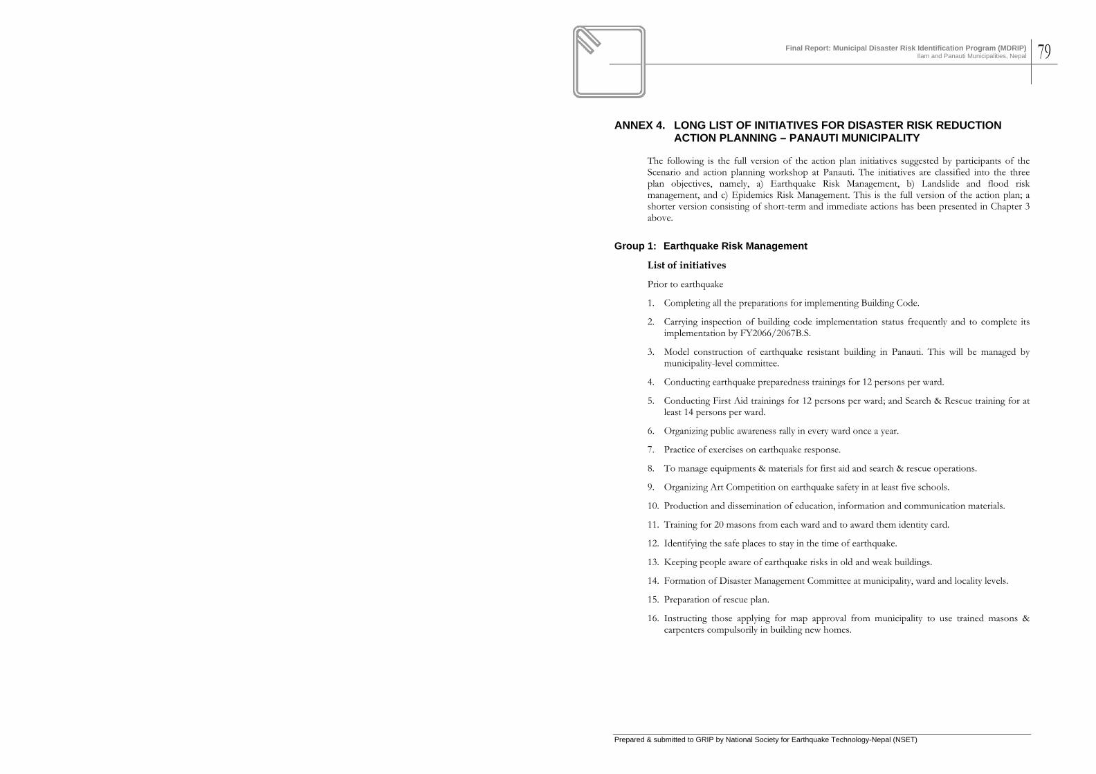
Final Report: Municipal Disaster Risk Identification Program (MDRIP)
Ilam and Panauti Municipalities, Nepal 79
Prepared & submitted to GRIP by National Society for Earthquake Technology-Nepal (NSET)
ANNEX 4. LONG LIST OF INITIATIVES FOR DISASTER RISK REDUCTION ACTION PLANNING – PANAUTI MUNICIPALITY
The following is the full version of the action plan initiatives suggested by participants of the Scenario and action planning workshop at Panauti. The initiatives are classified into the three plan objectives, namely, a) Earthquake Risk Management, b) Landslide and flood risk management, and c) Epidemics Risk Management. This is the full version of the action plan; a shorter version consisting of short-term and immediate actions has been presented in Chapter 3 above.
Group 1: Earthquake Risk Management
List of initiatives
Prior to earthquake
1. Completing all the preparations for implementing Building Code.
2. Carrying inspection of building code implementation status frequently and to complete its implementation by FY2066/2067B.S.
3. Model construction of earthquake resistant building in Panauti. This will be managed by municipality-level committee.
4. Conducting earthquake preparedness trainings for 12 persons per ward.
5. Conducting First Aid trainings for 12 persons per ward; and Search & Rescue training for at least 14 persons per ward.
6. Organizing public awareness rally in every ward once a year.
7. Practice of exercises on earthquake response.
8. To manage equipments & materials for first aid and search & rescue operations.
9. Organizing Art Competition on earthquake safety in at least five schools.
10. Production and dissemination of education, information and communication materials.
11. Training for 20 masons from each ward and to award them identity card.
12. Identifying the safe places to stay in the time of earthquake.
13. Keeping people aware of earthquake risks in old and weak buildings.
14. Formation of Disaster Management Committee at municipality, ward and locality levels.
15. Preparation of rescue plan.
16. Instructing those applying for map approval from municipality to use trained masons & carpenters compulsorily in building new homes.

Final Report: Municipal Disaster Risk Identification Program (MDRIP)
Ilam and Panauti Municipalities, Nepal 80
Prepared & submitted to GRIP by National Society for Earthquake Technology-Nepal (NSET)
Objective: to conduct public awareness programs on reduction of earthquake damages in Panauti municipality.
Proposed activities
S.N. Activities Start date End date Lead organization Supporting Organization
Estimated budget
1 Implementing Building Code
May 2009 May 2012 Planning section of Municipality, DE-DUDBC
Municipality, Wards, DUDBC
2 Model construction of earthquake resistant building
July 2009 June 2010 DDC, Consumers Group, Local organizations
3 Training on earthquake preparedness to community people
September 2009
March 2010
Training officers from NSET
Local committee members
(4 days)
4 First aid training March 2010 September 2010
Red Cross 40000
5 Community level trainings on general search & rescue
August 2010 April 2011 Police, Army 50000
6 Mason training on construction of earthquake resistant building
June 2009 Nov 2013 NSET Local masons
7 Earthquake awareness rally
Jan 16 every year
School, municipality, clubs, Red Cross
8 Managing materials and equipments for first aid and community level search & rescue tasks
2009 2012 Health posts, Police, Army, Red Cross, Municipality,
9 Art competition 4 per year Municipality, NSET, Schools
10 Production & Dissemination of Awareness material
Aug 2009 Sep 2012 Municipality, schools, public health institutions
11 Formation of disaster management committee
April 2009 March 2011
Municipality, wards and localities
For post earthquake situations
Title of plan: Post earthquake damage reduction
Mission of plan: Reducing post earthquake damages
Objectives: to reduce immediate damages
S.N. Activities Start Finish
Participating agencies
1 First Aid Immediately needed CDO and supporting agencies
2 Temporary settlement Immediately Health posts, volunteers
3 Reconstruction of damaged buildings
Local authority, municipality, ward, NGOs, NRCS, Scout

Final Report: Municipal Disaster Risk Identification Program (MDRIP)
Ilam and Panauti Municipalities, Nepal 81
Prepared & submitted to GRIP by National Society for Earthquake Technology-Nepal (NSET)
What to do during earthquake shaking?
1. Be seated in safe place like under table, follow “Duck, Cover and Hold” to protect sensitive parts of body.
2. Don’t move towards areas of potential risks like ladders, nearby glasses or heavy parts.
3. Don’t make noise, keep patience.
4. Ask for help with whistle or any material available nearby.
List of activities for post earthquake situations
1. Move to safe place
2. Search and rescue people injured and buried under earth
3. Switch off electricity supply and manage inflammable materials
4. Make first aid treatments immediately and move the injured ones to hospital at the earliest.
5. Learn about the status of own family members
Group 2: Landslide and Flood Hazard Risk Management
Problem: Preparedness for floods and landslide
S. No. Activity Starting date Completion date
Lead Agency Supporting Institutions
1 Identification of areas
1.1 Field visits April 2008 May 2009 Concerned wards
District office of landslides, other agencies
1.2 Interaction with stakeholders
Planning section Stakeholders, ward, media
1.3 Information collection from prone areas
June 2009 Concerned wards
District landslide office
1.4 Identifying locations prone to flood & landslide
July 2009 Aug 2009 Planning section District landslide office
2 Public awareness
2.1 Discussions and interactions on probable disasters
June 2009 Nov 2009 Planning section- Municipality
NSET
2.2 workshops Available institutions
2.3 Newspaper/ Hoarding boards
2.4 Radio programs
3 Plantation
3.1 In river banks June 2009 June 2009 District forest office
Users’ groups
3.2 In inclined lands
3.3 Making terrain in inclined lands
Oct 2009 Feb 2010 District Users’ groups
3.4 Conservations of plants Continuous campaign
Users’ groups, Municipality, NGOs and others
4 Determining the

Final Report: Municipal Disaster Risk Identification Program (MDRIP)
Ilam and Panauti Municipalities, Nepal 82
Prepared & submitted to GRIP by National Society for Earthquake Technology-Nepal (NSET)
S. No. Activity Starting date Completion date
Lead Agency Supporting Institutions
standards for rivers and streamlets
4.1 Identifying areas of flow as per maps for the narrowed ones
Nov 2009 Jan 2010 Planning section-Municipality
5 Conservation of structures
5.1 Cleaning & repair-maintenance of irrigation canals
Feb 2010 May 2010 Municipality Users’ groups
5.2 Repair-maintenance & new construction of check dams, support walls
Aug 2010 Dec 2010 DWIDP Municipality
5.3 Improvement of tracks Jan 2011 March 2011 Users’ groups Planning section- Municipality
5.4 Mines management Mines entrepreneurs
5.5 Conservation of springs for drinking water
Water supply corporation
Users’ group, Municipality
It needs to make Disaster Management Fund and designate section and person to take care of.
To-do List: during the period of flood and landslide
Objectives: Rescue and Treatment
1. Community people and organizations
2. Institutions for emergency first aid
3. To make optimum utilization of resources available.
a. Stretcher
b. Baskets, ropes
c. Bamboo
d. Cloths, plastics
4. Immediate food supply and temporary dwellings
a. Huts/ sheds
b. Schools
c. Tents
d. Dry foods
5. Media mobilization for supports
a. Red Cross
b. Army, Police
c. Transportation

Final Report: Municipal Disaster Risk Identification Program (MDRIP)
Ilam and Panauti Municipalities, Nepal 83
Prepared & submitted to GRIP by National Society for Earthquake Technology-Nepal (NSET)
To-do list: After flood/landslide
1. Sanitation
a. Remove crumbled earth: Municipality, Social organizations
b. Remove dead animals: Local clubs, NGOs
2. Reconstruction
a. Field visits: municipality, landslide office
b. Transfer and temporary dwellings
c. Basic relief materials distribution (after temporary settlement)
d. Physical infrastructures and plantations
Group 3: Epidemics Risk Management
Mission: reduction of cholera
Objectives: to provide pure drinking water in the rate of 45 litters per person for 30000 residents of Panauti Municipality within the period of March 2009 to February 2012.
Activities
1. Cleaning source springs
2. Constructing tanks
3. Frequent activities of water treatment
4. Laboratory test of sample water in every third month
5. Scientifically proportional distribution of water for various areas
During the period of epidemics
1. Coordinate information dissemination: community people, municipality
2. Mobilizing technical rescue team: Red Cross, Community
3. Managing ambulance and mobilizing health services: municipality, Red Cross
4. After spreading out of epidemics
a. Monitoring: municipality
b. Data collection: Red Cross, Community
c. Collection & distribution of Relief materials
Title of plan: Epidemics Risk Reduction
Mission: Reduction of Potential of Cholera Outbreak
Objective: To manage pure drinking water

Final Report: Municipal Disaster Risk Identification Program (MDRIP)
Ilam and Panauti Municipalities, Nepal 84
Prepared & submitted to GRIP by National Society for Earthquake Technology-Nepal (NSET)
S. No. Activity Starting Date
Completing Date
Lead Agency Supporting institutions
Estimated Budget
1 Cleaning the source springs
April 1, 2009
continuously Concerned users’ group
Municipality, Water supply corporation
2 Construction and repair of water tank
May 1, 2009 May 15, 2009
Concerned users’ group
Municipality, Water supply corporation, DDC
3 Water treatment March 15, 2009
continuously Public health office
Municipality
4 Laboratory test March 2009 continuously Water supply corporation
5 Toilet construction Mar 2009 2012 Concerned users’ group
Municipality,
6 Drainage and waste management
7 Trainings on sanitation
8 Conduction training Mar 15, 2009
June 2009 Community Public health office, municipality
9 Managing stretchers June 2009 Nov 2009 Red Cross
10 First aid kit Mar 2009 June 2009 Red Cross
11 Awareness programs
12 Information dissemination from FM radios
Mar-July every year
continuously Municipality, District health office
13 Posters, Pamphlets

Final Report: Municipal Disaster Risk Identification Program (MDRIP)
Ilam and Panauti Municipalities, Nepal 85
Prepared & submitted to GRIP by National Society for Earthquake Technology-Nepal (NSET)
ANNEX 5. LIST OF ACTION PLAN CONTRIBUTORS- ILAM MUNICIPALITY
MUNICIPAL DISASTR RISK MANAGEMENT PROJECT MUNICIPAL DISASTER RISK IDENTIFICATION PROJECT (MDRIP)
Disaster Scenario and Action Planning Workshop Date: December 8‐9, 2008 List of Plan Contributors
S. No. Name Position Organization Government
1 Tarani Prasad Shahu Mgmt. Officer
2 Megh Nath Dhungana Asst. Sub. Engineer Ilam Municipality
3 Bhanu Bhakta Baral C.D. O Office
4 Sudershan Prasad Dhakal CDO C.D. O Office
5 Prem Prasad Pandey Assistant DDC Ilam
6 Urmila Awale Assistant DDC Ilam
7 Menuka Parajuli Representative DDC Ilam
8 Bijay Bikram Subba Engineer DUDBC
9 Suresh Nemang Div. Engineer DUDBC
10 Govinda Thapa Lt. Coronel Nepal Army
11 Sushil Baniya Lt. Coronel Nepal Army
12 Kamal Regmi Asst. Engineer DDC Ilam
Hospital 13 Dr. Dinesh Kumar Bim Medical Officer Ilam Hospital
14 Dr. Niraj Rauniyar Medical Officer Ilam Hospital
15 Deepesh Rai Admin. Officer Community Hospital
16 Dr. Shishir Gurung Medical Officer Community Hospital
Ilam Municipality 17 Bhim Prasad Poudel Exe. Officer Ilam Municipality
18 Radha Krishna Ghimire Asst. Engineer Ilam Municipality
19 Ram Kumar Shah Assistant Ilam Municipality
20 Sachidananda Pokharel Engineer Ilam Municipality
Media 21 Diwakar Bhandari Program Coordinator Ilam F. M
22 Yogendra Shankar Representative Ilam F. M
23 Geeta Bishwokarma Program Coordinator Nepal Bani
24 Sabita Pandey Program Coordinator Nepal Bani
25 Satandra Jabegu President Nepal Journalist Association
26 Bichar Singh Lawati Representative Radio Fikkal
27 Dilli Chapagain RSS
28 Govinda Lamichhane Reporter RSS
29 Sujan Timilsena Reporter Ilam F. M
30 Rohit Chandra Bhattarai Editor Sandakpur Daily
Academic 31 Sharmila Sharma Morang Campus
Private Organization 32 Tara Kumar Eakten Electrician NEA

Final Report: Municipal Disaster Risk Identification Program (MDRIP)
Ilam and Panauti Municipalities, Nepal 86
Prepared & submitted to GRIP by National Society for Earthquake Technology-Nepal (NSET)
S. No. Name Position Organization 33 Dev Kumar Kuwar Representative NEA
34 Renu Shankar Gautam Sr. Assistant Nepal Telcom
35 Dilip Kumar Engineer Water Supply
36 Hari B. Dahal Sec. Officer Water Supply
37 Deelip Kumar Shah Engineer Water Supply
NGO 38 Ashok Khaki Office Secretary NGO
39 Amod Mani Dixit Executive Director NSET
40 Bijay K. Upadhyaya NSET
41 Suresh Chaudhary NSET
42 Niva Upreti NSET
43 Rabindra Shrestha Secretary Red Cross
44 Shiva Prasad Gautam Dy. Secretary Red Cross
45 Tek Prasad Ranjitkar Secretary Red Cross
46 Bika Dewan Member Tole Development
47 Jyoti Mala Pradhan Secretary Sungava Dev.
48 Kamala Baral Member Women Dev. Org.
Political Party
49 Ganesh Prasad Baral Acting Secretary Nepal Communist Party (United Marxist-Leninist)
50 Kedar Thapa Secretary Political Party (Nepali Congress)
51 Bhim Kulung Kirat Secretary Nepal Communist Party United (Maoist)
52 Chabi Rai "Raj" Member Nepal Communist Party (Marxist)
53 Jiven Sharma Member Nepal Communist Party (Marxist)
54 Thakur Sing Nemwang Member Janamorcha Nepal
55 Bishnu Maya Bohora Activist Nepal Communist Party United (Maoist)
56 Shiva Subedi Representative Janamorcha Nepal
Others
57 Mahesh Basnet
58 Hari Chandra Dahal Principal
59 Sadhu Sharan Purbe Engineer
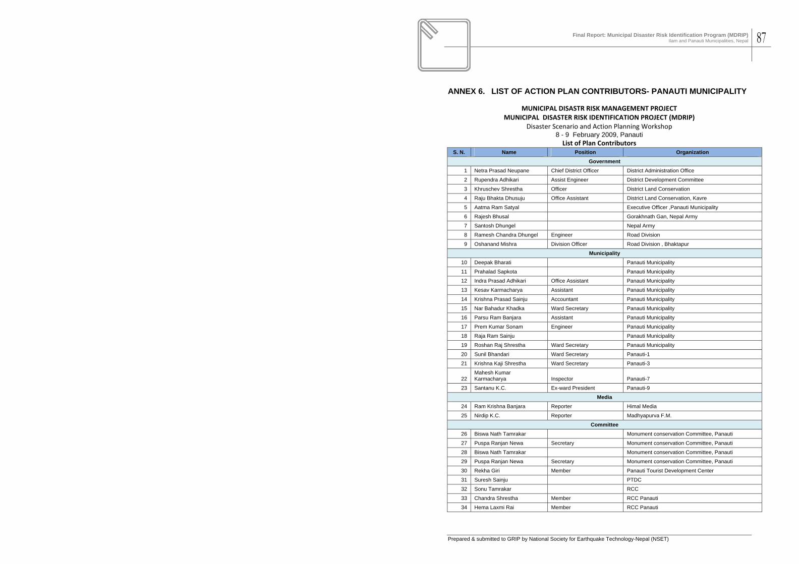
Final Report: Municipal Disaster Risk Identification Program (MDRIP)
Ilam and Panauti Municipalities, Nepal 87
Prepared & submitted to GRIP by National Society for Earthquake Technology-Nepal (NSET)
ANNEX 6. LIST OF ACTION PLAN CONTRIBUTORS- PANAUTI MUNICIPALITY
MUNICIPAL DISASTR RISK MANAGEMENT PROJECT MUNICIPAL DISASTER RISK IDENTIFICATION PROJECT (MDRIP)
Disaster Scenario and Action Planning Workshop 8 - 9 February 2009, Panauti List of Plan Contributors
S. N. Name Position Organization Government
1 Netra Prasad Neupane Chief District Officer District Administration Office
2 Rupendra Adhikari Assist Engineer District Development Committee
3 Khruschev Shrestha Officer District Land Conservation
4 Raju Bhakta Dhusuju Office Assistant District Land Conservation, Kavre
5 Aatma Ram Satyal Executive Officer ,Panauti Municipality
6 Rajesh Bhusal Gorakhnath Gan, Nepal Army
7 Santosh Dhungel Nepal Army
8 Ramesh Chandra Dhungel Engineer Road Division
9 Oshanand Mishra Division Officer Road Division , Bhaktapur
Municipality 10 Deepak Bharati Panauti Municipality
11 Prahalad Sapkota Panauti Municipality
12 Indra Prasad Adhikari Office Assistant Panauti Municipality
13 Kesav Karmacharya Assistant Panauti Municipality
14 Krishna Prasad Sainju Accountant Panauti Municipality
15 Nar Bahadur Khadka Ward Secretary Panauti Municipality
16 Parsu Ram Banjara Assistant Panauti Municipality
17 Prem Kumar Sonam Engineer Panauti Municipality
18 Raja Ram Sainju Panauti Municipality
19 Roshan Raj Shrestha Ward Secretary Panauti Municipality
20 Sunil Bhandari Ward Secretary Panauti-1
21 Krishna Kaji Shrestha Ward Secretary Panauti-3
22 Mahesh Kumar Karmacharya Inspector Panauti-7
23 Santanu K.C. Ex-ward President Panauti-9
Media 24 Ram Krishna Banjara Reporter Himal Media
25 Nirdip K.C. Reporter Madhyapurva F.M.
Committee 26 Biswa Nath Tamrakar Monument conservation Committee, Panauti
27 Puspa Ranjan Newa Secretary Monument conservation Committee, Panauti
28 Biswa Nath Tamrakar Monument conservation Committee, Panauti
29 Puspa Ranjan Newa Secretary Monument conservation Committee, Panauti
30 Rekha Giri Member Panauti Tourist Development Center
31 Suresh Sainju PTDC
32 Sonu Tamrakar RCC
33 Chandra Shrestha Member RCC Panauti
34 Hema Laxmi Rai Member RCC Panauti

Final Report: Municipal Disaster Risk Identification Program (MDRIP)
Ilam and Panauti Municipalities, Nepal 88
Prepared & submitted to GRIP by National Society for Earthquake Technology-Nepal (NSET)
S. N. Name Position Organization 35 Sarswoti Kandel Treasure RCC Panauti
36 Laxmi Krishna Tamrakar President RCC, Panauti
Political Party 37 Dhandash Somname President Janamorcha Nepal
38 Ramesh Kunwar Secretary Nepal Community Party United Marxist-Leninist (UML)
39 Mukunda Sapkota Assist-Secretary Nepali Congres
40 Ram Krishan Prajapati President Nepal Majdoor Kisan Party
Private Organization 41 Rajendra Mahaju President JCI Panauti
42 Suman Maske JGC JCI Panauti
43 Ram Kumar Basnet Sub-engineer M.E.S.
44 Binod Subedi Assistant Nepal Electricity Authority
45 Shyam Suwal Engineer Nepal Electricity Authority
46 Prahalad Neupane Nepal water Supply Corporation
NGO 47 Gopal Man Khatri President Nepal Red Cross Society
48 Binod Lamichhane Office Assistant Nepal Red Cross Society, Kavre
49 Shekhar Regmi Office Assistant Nepal Red Cross Society, Kavre
50 Keshav Banjara President Nepal Red Cross Society, Kharibot
51 Ram Hari Guragain Assist-Seceretary Nepal Red Cross Society, Khopasi
52 Laxmi Narayan Shrestha President Redcross
53 Amod Mani Dixit NSET
54 Bijay Upaddhyaya NSET
55 Ranjan Dhungel NSET
56 Suresh Chaudhary NSET
Academic 57 Surya Prasad Lakoju Principal School
58 Uttam Krishna Tamrakar Principal Shree Ram Higher Secondary School
59 Narayan Prasad Aryal Tejganga Campus
60 Ambu Bhawani Karki Campus Chief Tilganga Campus
Other 61 Bed Peasad Banjara Ex-ward President
62 Gopal Chaulagain
63 Gyan Bahadur Lama
64 Pawan Khadka Ex-ward Member
65 Pratirodh Adhikari
66 Somlal Pouju