Embed Size (px)
Citation preview

Multi-Scale Predictions of Storm-Driven Erosion,Breaching, and Flooding of Barrier Islands
Alireza Gharagozlou
Department of Civil, Construction and Environmental Engineering
North Carolina State University
PhD Research Proposal
August 7, 2019
Acknowledgements
Thesis Committee:
Dr. Casey Dietrich1
Dr. Rafael Canizares2 Dr. Helena Mitasova3
Dr. Alejandra Ortiz1 Dr. Margery Overton1
1 Department of Civil, Construction and Environmental Engineering, North Carolina State University, Raleigh, NC
2 COWI North America Inc., New York, NY
3 Department of Marine, Earth and Atmospheric Sciences, North Carolina State University, Raleigh, NC
2

• Introduction
• Proposed Research
• Numerical Models
• Preliminary Results
• Proposed Tasks
Outline• Barrier islands vulnerability
• Storm impacts
• Predicting the impacts
• Objectives
• Erosion, Breaching, Coupling
• Hypotheses
• XBeach
• ADCIRC+SWAN
3

• Introduction
• Proposed Research
• Numerical Models
• Preliminary Results
• Proposed Tasks
4
• Modeling erosion, overwash and inundation
• Loose coupling
• Island breach modeling
• Two-way coupling
Outline

• Introduction
• Proposed Research
• Numerical Models
• Preliminary Results
• Proposed Tasks
5

Barrier Islands
Numerical Models
Proposed TasksPreliminary
ResultsIntroduction
Proposed Research
6
NC Outer Banks, Hurricane Florence 2018

Storm Impacts
Numerical Models
Proposed TasksPreliminary
ResultsIntroduction
Proposed Research
Matthew (2016), FLArthur (2014), NC
Florence (2018), NC
7
Irene (2011), NC

Morphodynamic models:
• Erosion, overwash, sediment transport, etc.
• High-resolution mesh
• Small-scale features
• Small domains
Modeling Tools
Numerical Models
Proposed TasksPreliminary
ResultsIntroduction
Proposed Research
Velasq
uez M
on
toya et al. (2
01
8)
8

Storm surge and flooding models:
• Tide, wave, current, flooding, etc.
• Large domains
• From back-barrier to open ocean
• Coarse mesh resolution
Modeling Tools
Numerical Models
Proposed TasksPreliminary
ResultsIntroduction
Proposed Research
Thomas et al. (2019)9

Resolution Difference
Numerical Models
Proposed TasksPreliminary
ResultsIntroduction
Proposed Research
10

Resolution Difference
Numerical Models
Proposed TasksPreliminary
ResultsIntroduction
Proposed Research
11

Resolution Difference
Numerical Models
Proposed TasksPreliminary
ResultsIntroduction
Proposed Research
12

• Widely used and very reliable models
• Not connected
• Coastal flooding models
• Efficient for modeling hydrodynamics on large domain
• Coarse mesh cannot resolve dune-scale features
• Do not consider morphology
This is a problem especially when significant erosion occur
What are the gaps?
Numerical Models
Proposed TasksPreliminary
ResultsIntroduction
Proposed Research
13

Connecting the models:
• Improve the accuracy of flooding predictions
• Predict large scale interactions of morphodynamics and hydrodynamic
• Study the damages to infrastructure from both sediment and water
Why is it Important?
Numerical Models
Proposed TasksPreliminary
ResultsIntroduction
Proposed Research
14

• Introduction
• Proposed Research
• Numerical Models
• Preliminary Results
• Proposed Tasks
15

1. Model storm-driven erosion, overwash, and inundation
2. Model breaching and channel formation during storm
3. Bridge the gap between region-scale and Island-scale models
Objectives
Numerical Models
Proposed TasksPreliminary
ResultsIntroduction
Proposed Research
16
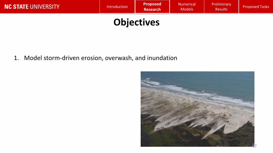
1. Model storm-driven erosion, overwash, and inundation
Objectives
Numerical Models
Proposed TasksPreliminary
ResultsIntroduction
Proposed Research
17

Overton et al. [2004], Clinch et al. [2012], Harter [2017]• Vulnerable spots, erosion, overwash• Storm surge estimation
McCall et al. [2010]
• Modeled the overwash in Santa Rosa Island during Hurricane Ivan (2004).
• Small domain size
A. Gharagozlou, J. C. Dietrich, A. Karanci, R. A. Luettich, and M. F. Overton “Storm-driven erosion and inundation of barrier islands from dune- to region-scales.” Coastal Engineering, 2019. Submitted.
1. Erosion & Overwash
Numerical Models
Proposed TasksPreliminary
ResultsIntroduction
Proposed Research
18
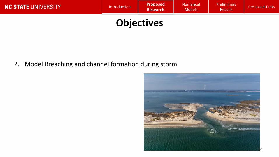
1. Model storm-driven erosion, overwash, and inundation
2. Model Breaching and channel formation during storm
3. Bridge the gap between region-scale and Island-scale models
Objectives
Numerical Models
Proposed TasksPreliminary
ResultsIntroduction
Proposed Research
19

Breaching:
• Connects back-barrier to the ocean
• Depends on storm properties and topography of the coast
• Impacts the hydrodynamics and morphodynamics of the region
2. Modeling Barrier Island Breaching
Numerical Models
Proposed TasksPreliminary
ResultsIntroduction
Proposed Research
20

Kraus [2003], De-Vet [2014], Elsayed et al. [2017]• Breaching, erosion, channel formation• Physic-based model improvement• Small domain models
Kurum and Overton [2013]
• Land cover effects on breaching• Multiple sediment layers • Different sediment properties (median size and erodability)
• Instead of calibration factors we will use bed friction
2. Modeling Breaching
Numerical Models
Proposed TasksPreliminary
ResultsIntroduction
Proposed Research
21

Research Questions:
How to include the processes involved in breaching?
How to predict the location and size of the breach?
How to apply the predictions on a large-scale domain?
2. Modeling Breaching
Numerical Models
Proposed TasksPreliminary
ResultsIntroduction
Proposed Research
22

Hypothesis 1:The accurate location and shape of breaching and channelization during a storm can be predicted only if information about the land cover and sub-layers are included.
Hypothesis 2:If we include a large-extent domain on the barrier island, significant large-scale impacts of breaching on water levels, flow velocities, and sediment transport can be studied.
Hypothesis 3:Via targeted coarsening of the mesh resolution, the computational time will be improved while the accuracy of the predictions in large scale will be maintained.
2. Modeling Breaching
Numerical Models
Proposed TasksPreliminary
ResultsIntroduction
Proposed Research
23

1. Model storm-driven erosion, overwash, and inundation
2. Model Breaching and channel formation during storm
3. Bridge the gap between region-scale and Island-scale models
Objectives
Numerical Models
Proposed TasksPreliminary
ResultsIntroduction
Proposed Research
24

Suh et al. [2015, 2017]• One-way coupling• Small domain
Cañizares and Irish [2008]
• Storm-driven erosion and breaching
• Coupling ADCIRC, Delft3D, and SBeach
• Suitable for simulating sediment overwash processes once the barrier island is fully inundated.
3. Coupling
Numerical Models
Proposed TasksPreliminary
ResultsIntroduction
Proposed Research
25

Research Questions:
How to connect the morphodynamics and hydrodynamics during the storm on local and regional scales?
How temporal and spatial resolution requirements for coupling impact the predictions?
3. Coupling
Numerical Models
Proposed TasksPreliminary
ResultsIntroduction
Proposed Research
26

Hypothesis 4:The prediction of flooding extents and large-scale impacts of storm on back-barrier hydrodynamics will be improved if ADCIRC and XBeach models are coupled and the bathymetry predictions are updated dynamically.
Hypothesis 5:In case of extensive breaching and channel formation, the frequency and duration of ground surface update has a significant impact on flooding predictions and can be modeled correctly if the temporal evolution of the breach is represented accurately.
3. Coupling
Numerical Models
Proposed TasksPreliminary
ResultsIntroduction
Proposed Research
27

• Introduction
• Proposed Research
• Numerical Models
• Preliminary Results
• Proposed Tasks
28

Xbeach (Roelvink [2009])
• Nearshore hydrodynamics and morphodynamics
• Depth-averaged shallow water equations, Short-wave action balance
• Infragravity waves
• Dune face avalanching
• Structured mesh
• Typical domain size of 2—20 km
• Typical resolution of 2—20 m
XBeach
Numerical Models
Proposed TasksPreliminary
ResultsIntroduction
Proposed Research
29Passeri et al. [2018]

ADCIRC+SWAN (Luettich et al [1992], Dietrich et al. [2013], Booij et al [1999])
• Powerful tool for flooding and storm surge modeling
• Finite-element model
• Shallow water equations, Wave action density equation
• Flexible, unstructured meshes
• Typical minimum resolution of 50—100 m
ADCIRC+SWAN
Numerical Models
Proposed TasksPreliminary
ResultsIntroduction
Proposed Research
30Cyriac et al. [2018]

• Introduction
• Proposed Research
• Numerical Models
• Preliminary Results
• Proposed Tasks
31

• Predict storm-driven erosion over large domains
• Develop techniques for coarsening predictions and coupling back to flooding models
Goals:
1. Validate XBeach erosion predictions on larger domains
- Quantify model performance on 30-km of Hatteras Island during Isabel
2. Evaluate XBeach accuracy at coarser resolution
- What happens if we use a coarser mesh?
3. Loose coupling XBeach and ADCIRC
- What are implications as a hydraulic control to stop or allow flooding?
- How ADCIRC predictions change with updated topography?
Motivations for Modeling Erosion
Numerical Models
Proposed TasksPreliminary
ResultsIntroduction
Proposed Research
32

Hurricane Isabel
• Survey width: 250-300 m
• High resolution LiDAR: 2m
• Covering large extent
• Erosion, overwash, and breaching
• Pre- and post-storm data:
16 Sep — 21 Sep 2003
Numerical Models
Proposed TasksPreliminary
ResultsIntroduction
Proposed Research
33

Computational grid:
• Alongshore: 15 m
• Cross shore: 3-35 m
Topo/Bathy data:
• Pre-storm LiDAR
• NC floodplain mapping DEM
Model setup:
• Simple model with minimal tuning
• To expand to other regions
• Waves and water levels from ADCIRC+SWAN
Study Area
Numerical Models
Proposed TasksPreliminary
ResultsIntroduction
Proposed Research
34

ObservationModel
1. XBeach Validation
Numerical Models
Proposed TasksPreliminary
ResultsIntroduction
Proposed Research
35

Skill Score (Sutherland et al. [2004])
• Skill Score > 0.5 is “Excellent”
• Model Skill Score = 0.59
1. XBeach Validation
Numerical Models
Proposed TasksPreliminary
ResultsIntroduction
Proposed Research
36

• Changing mesh spacing on smaller domain
• Alongshore
• Cross-shore
• Sensitivity of Skill Score to resolution
2. Resolution Sensitivity
Numerical Models
Proposed TasksPreliminary
ResultsIntroduction
Proposed Research
37

• Alongshore spacing
Mesh Skill Bias5m 0.68 -0.06
10m 0.69 -0.0715m 0.68 -0.0620m 0.69 -0.0630m 0.69 -0.0650m 0.67 -0.05
100m 0.69 -0.03200m 0.69 -0.03
2. Resolution Sensitivity
Numerical Models
Proposed TasksPreliminary
ResultsIntroduction
Proposed Research
38

Mesh Skill Bias3m 0.68 -0.065m 0.60 -0.05
10m 0.51 -0.0315m 0.27 -0.0330m 0.07 0.33
2. Resolution Sensitivity
• Cross-shore spacing
Numerical Models
Proposed TasksPreliminary
ResultsIntroduction
Proposed Research
39

3. Loose Coupling
Numerical Models
Proposed TasksPreliminary
ResultsIntroduction
Proposed Research
40

3. Loose Coupling
Observed pre-storm Observed post-storm XBeach prediction
Numerical Models
Proposed TasksPreliminary
ResultsIntroduction
Proposed Research
41
Mesh elevation in the
beginning of the model:

3. Loose Coupling
Pre-storm topo XBeach prediction
Numerical Models
Proposed TasksPreliminary
ResultsIntroduction
Proposed Research
42

1. XBeach performance:
• Model performance on 30 km domain is very encouraging
• Beach profile, Erosion events, flooding extents match post-storm observation
2. XBeach mesh resolution:
• Skill score is not sensitive to alongshore mesh spacing
• Skill score gets worse as the cross-shore mesh resolution increases
3. ADCIRC-updated topo/bathy:
• Beach and dune erosion contribute to flooding predictions
• Results match the prediction in XBeach and post-storm observation
Conclusion
Numerical Models
Proposed TasksPreliminary
ResultsIntroduction
Proposed Research
43

1. Lack of Island Breaching:
• During Isabel, an inlet was formed near Cape Hatteras
• Channel formation can contribute to surge and flooding
• The morphodynamics of breaching should be included in the model
2. Loose one-way coupling:
• Static approach was used to update the bathymetry
• Predictions did not account for temporal evolution of the surface
• ADCIRC starts with a topography that has been already affected by the storm
• Two-way coupling is needed to update the surface dynamically
Limitations
44
Numerical Models
Proposed TasksPreliminary
ResultsIntroduction
Proposed Research

• Introduction
• Proposed Research
• Numerical Models
• Preliminary Results
• Proposed Tasks
45

Isabel Inlet (2003)
• Three channels• Total width of 520 m• Maximum depth of 6 m• Closed by USACE
Region-Scale Predictions of Breaching
Numerical Models
Proposed TasksPreliminary
ResultsIntroduction
Proposed Research
46

Study Area and Computational Meshes
• 2-km and 15-km domains• Minimum resolution
• Alongshore: 2 m (5, 10 m)• Cross-shore: 2m (5, 10 m)
• Maximum alongshore spacing: 10 m (20, 30 m)
Region-Scale Predictions of Breaching
Numerical Models
Proposed TasksPreliminary
ResultsIntroduction
Proposed Research
47

Hypothesis 1: Modeling shape of the breach using land cover and sub-layer impacts.
Hypothesis 2: Studying the significant large-scale impacts of breaching
Hypothesis 3: Mesh coarsening and improving the computational time
Hypotheses
48
Numerical Models
Proposed TasksPreliminary
ResultsIntroduction
Proposed Research

Modeling the breach
Region-Scale Predictions of Breaching
Numerical Models
Proposed TasksPreliminary
ResultsIntroduction
Proposed Research
49
Idealized domain (T1 tests)
• Uniform bathymetry (2-km domain)
Realistic domain (T2 tests)
• Real topo/bathymetry (2-km and 15-km domains)
• Land cover (H1)
• Sub-layer (H1)
• Land cover + sub-layer (H1)
• Mesh resolution sensitivity (H3)
• Multi-scale impacts of pre-existing channel (H1, H2)
• Multi-scale impacts of Hindering the breaching (H1, H2)

Region-Scale Predictions of Breaching
Numerical Models
Proposed TasksPreliminary
ResultsIntroduction
Proposed Research
50
T1-5: Pre-existing 50-m channel
T1-6: Pre-existing 300-m channel

T2-5: Breaching will be hindered
Region-Scale Predictions of Breaching
Numerical Models
Proposed TasksPreliminary
ResultsIntroduction
Proposed Research
51

Time-varying bathymetry update
Two-way coupling
Implemented in ADCIRC
by Dr. Chris Massey
Coupling ADCIRC and XBeach
Time Step Loop
Solve
GWCE( z )
Update
WAD
Solve
Momentum
Equations
( V )
Update
Bathymetry
During BTP
( z )
itb
1itb
+*tb
BCHGTIMINC
BTIMINC
Linearly ChangesNo Changes
Numerical Models
Proposed TasksPreliminary
ResultsIntroduction
Proposed Research
52

Hypothesis 4: Two-way coupling of models with temporal bathymetry update
Hypothesis 5: Evaluating the temporal resolution requirements
Hypotheses
53
Numerical Models
Proposed TasksPreliminary
ResultsIntroduction
Proposed Research

Numerical Models
Proposed TasksPreliminary
ResultsIntroduction
Proposed Research
54
Coupling models
Idealized domain (T3 tests)
Realistic domain (T4 tests)
Coupling ADCIRC and XBeach
• Loose coupling (H4)
• Two-way coupling (H4)
• Varying temporal resolution (H5)
• Linear surface update (H5)
• Changing breach size (H4,5)
• Changing lagoon size (H4,5)
• Blocking the existing inlets (4)
Region-Scale Predictions of Breaching
Numerical Models
Proposed TasksPreliminary
ResultsIntroduction
Proposed Research
55
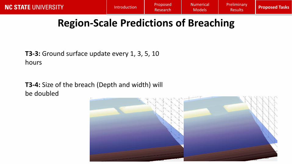
T3-3: Ground surface update every 1, 3, 5, 10 hours
T3-4: Size of the breach (Depth and width) will be doubled

Region-Scale Predictions of Breaching
Numerical Models
Proposed TasksPreliminary
ResultsIntroduction
Proposed Research
56
T4-4: The existing inlets along the barrier island will be blocked

Plan of Work
Numerical Models
Proposed TasksPreliminary
ResultsIntroduction
Proposed Research
57
• Need to study the large-scale and small-scale storm impacts
• We use ADCIRC+SWAN and XBeach
• Erosion, overwash, flooding
• Barrier island breaching
• Connecting the models
• Two-way coupled modeling approach
• Predicting multi-scale morphodynamics and hydrodynamic impacts
• Improving the flooding predictions
• Preliminary step toward real-time predictions of morpho- and hydrodynamics during storm
• Contributing to the literature
Summary
Numerical Models
Proposed TasksPreliminary
ResultsIntroduction
Proposed Research
58

Thank You!
59