Embed Size (px)
Citation preview
Background Report
June 2002Date endorsed by WAPC
Mulga QueenLayout Plan 1
Amendments Amendment 1 - September 2012Amendment 2 - May 2016

MULGA QUEEN LAYOUT PLAN 1
Mulga Queen Layout Plan 1 was prepared in 1999 by consultants Hames Sharley.
The background report prepared at that time is now significantly out-of-date and has been effectively superseded by the Amendment 1 report prepared during 2011/12 (attached).

Mulga Queen Layout Plan No. 1
Amendment 1
March 2012
Prepared by the Department of Planning in partnership with Nurra Kurramunoo Aboriginal Corporation

_________________________________________________________________________________________________________ Mulga Queen Layout Plan No. 1 Amendment 1-
1
CONTENTS EXECUTIVE SUMMARY ................................................................................................................ 2 DEVELOPMENT PRIORITIES ........................................................................................................ 4 1 BACKGROUND ...................................................................................................................... 5 1.1 LOCATION & SETTING ............................................................................................................... 5 1.2 CLIMATE .................................................................................................................................. 5 1.3 HISTORY .................................................................................................................................. 6 2 COMMUNITY PROFILE ............................................................................................................ 7 2.1 POPULATION ............................................................................................................................ 7 2.2 GOVERNANCE .......................................................................................................................... 8 2.3 LAND TENURE .......................................................................................................................... 8 2.4 NATIVE TITLE ........................................................................................................................... 9 2.5 ABORIGINAL HERITAGE ........................................................................................................... 10 2.6 COMMUNITY ASPIRATIONS ...................................................................................................... 11 3 EXISTING INFRASTRUCTURE & SERVICES ...................................................................... 12 3.1 HOUSING ............................................................................................................................... 12 3.2 FLOODING & DRAINAGE .......................................................................................................... 12 3.3 WATER SUPPLY ..................................................................................................................... 13 3.4 ELECTRICITY SUPPLY ............................................................................................................. 13 3.5 RUBBISH DISPOSAL ................................................................................................................ 13 3.6 WASTEWATER ........................................................................................................................ 14 3.7 ACCESS & DEDICATED ROADS ................................................................................................ 14 3.8 INTERNAL ROAD LAYOUT ........................................................................................................ 14 3.9 COMMUNITY AND SOCIAL SERVICES ........................................................................................ 15 3.10 EMPLOYMENT OPPORTUNITIES ............................................................................................. 15 4 RECOMMENDATIONS ......................................................................................................... 16 4.1 DESIGN SUMMARY ................................................................................................................. 16 4.2 RUBBISH TIP .......................................................................................................................... 16 4.3 HOUSING ............................................................................................................................... 16 4.4 ROAD LAYOUT AND SL-LOT NUMBERING .................................................................................. 17 4.5 NO-GO AREA ......................................................................................................................... 17 4.6 RURAL ................................................................................................................................... 17 4.7 RECOMMENDED COMMUNITY LIVING AREA .............................................................................. 17 4.8 RECOMMENDED SETTLEMENT ZONE ........................................................................................ 17 5 PLANNING FRAMEWORK ................................................................................................... 19 5.1 STATE PLANNING POLICIES ..................................................................................................... 19 5.2 ABORIGINAL SETTLEMENTS GUIDELINE 1 ................................................................................. 19 5.4 SHIRE OF LAVERTON TOWN PLANNING SCHEME NO.2 .............................................................. 19 6 CONSULTATION, REFERENCES & INFORMATION ............................................................ 20

_________________________________________________________________________________________________________ Mulga Queen Layout Plan No. 1 Amendment 1-
2
Community Contact Details
Acronyms AHA : Aboriginal Heritage Act (WA) 1972
ATSIC : Aboriginal and Torres Strait Islander Commission
CR : Crown Reserve
DoH : Department of Housing
DIA : Department of Indigenous Affairs
DoP : Department of Planning
EHNS : Environmental Health Needs Survey
ILUA : Indigenous Land Use Agreement (under the Native Title Act 1993)
LP : Layout Plan
NKAC : Nurra Kurramunoo Aboriginal Corporation
NNTT : National Native Title Tribunal
NTA : Native Title Act (Commonwealth) 1993
NTRB : Native Title Representative Body
PBC : Prescribed Body Corporate (under the NTA, representing native title holders)
RAESP : Remote Area Essential Services Program
SL-lot : Settlement Layout lot
UCL : Unallocated Crown Land
WAPC : Western Australia Planning Commission
Representative Organisation : Nurra Kurramunoo Aboriginal Corporation
Community contacts : Vanessa Thomas
Telephone : 08 9037 5958
Postal Address : PO Box 177, Laverton WA 6440
Layout Plans & the Development Process
Layout Plans provide a structure for future development. LP preparation includes with consultation with a range of relevant government authorities and agencies, but it is not development approval.
Prior to commencing development a range of consents, approvals, licenses and clearances may be required.
It is the responsibility of the developer to ensure that all relevant consents, approvals, licences and clearances are in place prior to commencing physical works on site.
Organisations responsible for such matters may include the landowner, local government, incorporated community council, native title representative body, Department of Environment & Conservation, Aboriginal Cultural Materials Committee, Environmental Protection Authority, Department of Consumer & Employment Protection and Department of Water.
_________________________________________________________________________________________________________ Mulga Queen Layout Plan No. 1 Amendment 1
3
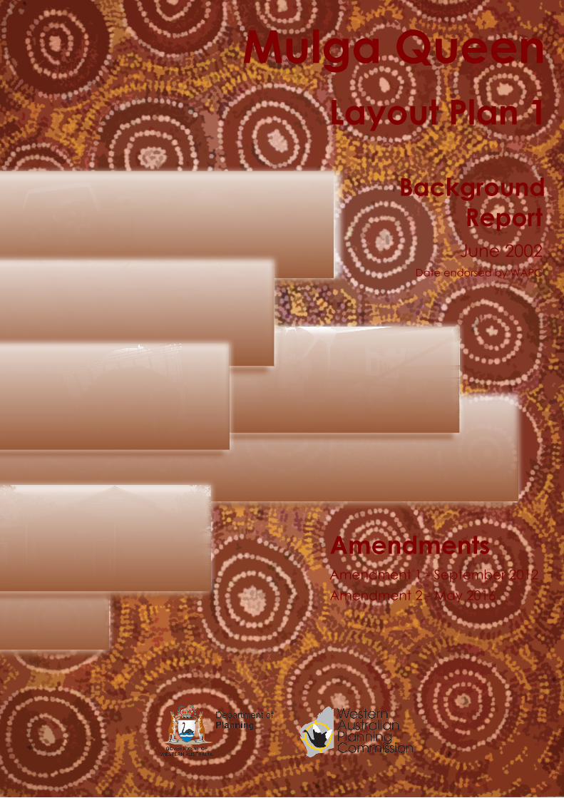
EXECUTIVE SUMMARY Mulga Queen Layout Plan (LP) No.1 was prepared by consultants Hames Sharley in 1999, and
was endorsed by the WAPC on 18 June 2002. Mulga Queen LP No.1 Amendment 1 has been
prepared based on requests made by the community (4 October 2011). The tables below
summarise the main issues concerning the planning, development and provision of services within
Mulga Queen, covered in more detail in the body of this report.
Table 1: Population details
Table 2: Infrastructure and essential/social service characteristics at Mulga Queen Infrastructure/service Indicator
Community Characteristics
Drinking water Water supplied by 2 unregulated bores, managed under the Ngaanyatjarra Essential Services program. Water is good in terms of quality and supply.
Native title Community is located within claim area of the Registered Wutha Native Title Claim WC99/10.
Secure land holding(s) The all community housing and infrastructure located on land with secure and appropriate tenure.
Flood / storm surge Pooling of water occurs. Infrastructure and housing at no immediate risk.
Emergency assistance Police Station located in Laverton, approximately 2hrs away by vehicle.
Education School based at the settlement servicing years K-10.
Health Health clinic located in the community. Though mobile clinic service not currently in operation.
Governance Incorporated community council Nurra Kurramunoo Aboriginal Corporation meeting regulatory requirements
Employment and enterprise opportunities
Some job opportunities exist within the community with further established job markets in surrounding mining operations.
Transport Access to the settlement via gravel road from Laverton. Managed by Local Government.
Food Store located in Laverton, approximately 2 hours away by vehicle and at Cosmo Newberry, approximately 1 hour away by vehicle.
Electricity Electricity provided via 2 diesel generators (not fully automoated), with a total output of 110kw. Electricity is unregulated and is serviced and managed by Ngaanyatjarra Essential Services.
Existing Population 50
Design Population 55
_________________________________________________________________________________________________________ Mulga Queen Layout Plan No. 1 Amendment 1
4
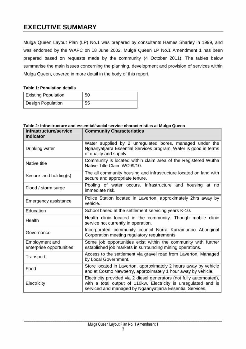
DEVELOPMENT PRIORITIES Mulga Queen LP No. 1 Amendment 1 plans for future expansion of the community and formalises
existing infrastructure and land-uses and provides a future lot layout and road design.
The primary purpose of amendments is to guide the growth and development of Mulga Queen by
providing a layout of future land uses in the community.
LP No.1 Amendment 1 has been prepared in consultation with the Nurra Kurramunoo Aboriginal
Corporation to ensure that the plan reflects the community's aspirations. Technical input from a
number of government and non-government agencies responsible for providing services and
infrastructure to the community has also been incorporated into the plan and this report.
The following initiatives, development and works are needed to implement LP No. 1
Amendment 1:
Within the next year:
1. Fill current rubbish tip and excavate second tip on Settlement Layout lot (SL-lot) 28.
Within the next 5 years:
1. Apply for Regional Airports Development Scheme (RADS) for funding to extend current
airstrip.
2. Clear SL-lots 8 & 9 for housing development.
Implementing the LP
The implementation of this LP will rely on the energy and endeavour of the community members. The future growth of Mulga Queen will require community members to find solutions for the provision of services and infrastructure (such as housing and sealed roads). This reinforces the objectives of Nurra Kurramunoo Aboriginal Corporation to help bring about the self support of its members by the development of economic projects and industries, and to encourage members to manage their affairs on their own land.
_________________________________________________________________________________________________________ Mulga Queen Layout Plan No. 1 Amendment 1-
5
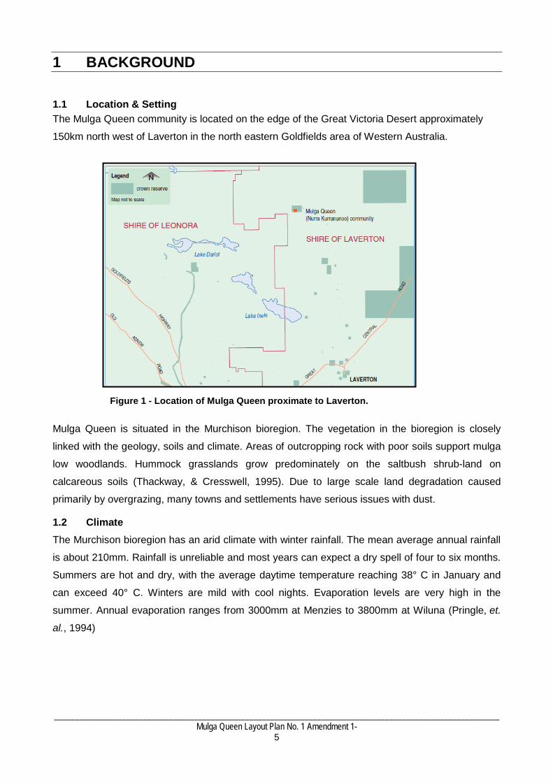
1 BACKGROUND 1.1 Location & Setting The Mulga Queen community is located on the edge of the Great Victoria Desert approximately
150km north west of Laverton in the north eastern Goldfields area of Western Australia.
Mulga Queen is situated in the Murchison bioregion. The vegetation in the bioregion is closely
linked with the geology, soils and climate. Areas of outcropping rock with poor soils support mulga
low woodlands. Hummock grasslands grow predominately on the saltbush shrub-land on
calcareous soils (Thackway, & Cresswell, 1995). Due to large scale land degradation caused
primarily by overgrazing, many towns and settlements have serious issues with dust.
1.2 Climate The Murchison bioregion has an arid climate with winter rainfall. The mean average annual rainfall
is about 210mm. Rainfall is unreliable and most years can expect a dry spell of four to six months.
Summers are hot and dry, with the average daytime temperature reaching 38° C in January and
can exceed 40° C. Winters are mild with cool nights. Evaporation levels are very high in the
summer. Annual evaporation ranges from 3000mm at Menzies to 3800mm at Wiluna (Pringle, et.
al., 1994)
Figure 1 - Location of Mulga Queen proximate to Laverton.

_________________________________________________________________________________________________________ Mulga Queen Layout Plan No. 1 Amendment 1
6
1.3 History The area in which Mulga Queen is currently located was a focus of gold discoveries and
prospecting activity from the 1890s onwards. The location was subsequently established as a
ration depot, thus becoming a major focus for camping activities of Aboriginal people from
surrounding areas.
Early reports from both anthropologists like Daisy Bates and government officers record the
frequent travel of Aboriginal people within a social zone encompassing Mulga Queen, Cosmo-
Newberry to the south-east, and Tjirrkarli further to the east. More travel within this traditional
social zone was enabled when Aboriginal people became increasingly involved in the pastoral
industry in the 1950s, with breaks in mustering schedules allowing Aboriginal workers to visit
relatives within these areas, as well as Laverton and Mt Margaret to the south-west.
The formal establishment of Mulga Queen as an Aboriginal community should be seen as part of a
broader out-station movement of the 1980s, whereby Aboriginal people sought to return to lands
with which they enjoyed ancestral ties. Particular families moved back to the area from Leonora in
1984, which was followed by the establishment of permanent buildings, and the establishment of a
community association in 1987. Residents of Mulga Queen are mindful of the cultural
responsibilities that attach to living in such an area, and take seriously the avoidance protocols that
relate to areas near the community that have important cultural associations.
Today, the community has a population of 50 people, with the majority of kin ties being shared with
people living in Leonora. Socially, it maintains relationships with other north-eastern Goldfields
centres, and the Esperance region, as many Mulga queen children attend secondary school there.

_________________________________________________________________________________________________________ Mulga Queen Layout Plan No. 1 Amendment 1
7
2 COMMUNITY PROFILE 2.1 Population Current Population Estimating and predicting populations on remote aboriginal communities can be difficult because
Aboriginal people tend to be mobile in terms of housing and living arrangements. Populations can
increase and decrease quite rapidly based on family, cultural or administrative factors (see Taylor
2006 for a useful discussion of demographic trends of remote Indigenous populations). Population
figures also vary depending on the time of year of enumeration, methods and sources by which
data are collected. Australian Bureau of Statistics (ABS) data has been criticised for
undercounting populations in remote communities (Memmot et al 2004).
Current population levels can be estimated from a range of sources, including Census Data from
the Australian Bureau of Statistics (ABS) and the Environmental Health Needs Survey undertaken
by the Department of Indigenous Affairs. The ABS has advised that recent census data for Mulga
Queen is unavailable as the settlement was not included as a discrete collector district in either the
2001 or 2006 censuses. The only known published population estimates for Mulga Queen are from
the Environmental Health Needs Survey (EHNS) undertaken by the Department of Indigenous
Affairs in 1997 and 2008. The 2008 ENNS recorded a population of 45.
A key source of population data is from the community itself. On 23 November 2011 the
community advised that Mulga Queens permanent population is between 45 - 50 people. In
accordance with the community’s advice and the 2008 EHNS, this report presumes the current
permanent population of Mulga Queen is 50 residents.
A summary of recent population data from these two sources follows:
Table 3: Population figures by source 1997-2011. 1997 2008 2011
Total persons 80 45 50
Source EHNS EHNS Community
Design Population Given that the population since 1997 have been somewhat erratic and showing a general
downward trend, it is difficult to project how the population of Mulga Queen might grow in the next
10 years. However, the population projections for the Shire of Laverton outlined in Western
Australia Tomorrow (WAPC 2005) indicates a 1 per cent annual growth rate. As such a 1 per cent
annual growth rate has been estimated for Mulga Queen. Based on a current population of 50 and
_________________________________________________________________________________________________________ Mulga Queen Layout Plan No. 1 Amendment 1
8
an annual growth rate of 1 per cent, is it estimated that the population of Mulga Queen could be
approximately 55 by the year 2021.
Migration to and from the community will be influenced among other things by employment
opportunities, family networks and obligations, services and infrastructure available in the
community (including number and type of housing). All the same, the estimates above can be used
as a reasonable though generalised estimate of population growth and the associated demand for
housing during the next ten years. These figures should be re-evaluated when the LP is next
updated (ie. roughly every five years). The estimated design population for Mulga Queen over a
10-year period, based on a current population of 50 and an annual growth rate of 1 per cent, is 55
residents.
2.2 Governance
Nurra Kurramunoo Aboriginal Corporation (NKAC) is the incorporated body responsible for the
management of the community. The corporation was registered on the 9th of September 1987
under the then Aboriginal Councils and Associations Act 1976. This Act was replaced in 2006 by
the Corporations (Aboriginal and Torres Strait Islander) Act 2006 (CATSI Act 2006).
The Incorporated Rule Book (registered on 27 June 2009) prescribes the decision making process
for the corporation. Documents for the Nurra Kurramunoo Aboriginal Corporation can be found on
the website for the Office of the Registrar of Indigenous Corporations (www.orac.gov.au).
2.3 Land Tenure The majority of housing and infrastructure associated with Mulga Queen is located on 1 crown land
title that is vested in the Aboriginal Lands Trust and leased to the Nurra Kurramunoo Aboriginal
Corporation. There are two buildings and some infrastructure located outside of the leased
community reserve on Reserve 9881 which is currently unmanaged (land is managed by the
Department of Regional Development and Lands (DRDL) by default). A proposed excision has
been lodged with DRDL that includes all housing and infrastructure not located on Crown Reserve
25060. The proposed excision can be viewed on the Landownership Plan.
The central living area is primarily located on a single land title:
Register Number Lot 39 on Deposited Plan 188348 Volume / Folio CR 25060 Status Order / Interest Reserve Under Management Order Primary Interest Holder Aboriginal Lands Trust Interests Leased to Nurra Kurramunoo Aboriginal Corporation

_________________________________________________________________________________________________________ Mulga Queen Layout Plan No. 1 Amendment 1
9
2.4 Native Title
Native title issues affecting Mulga Queen Mulga Queen is covered by two registered native title claims Wutha (WC99/10, WAD6064/98),
represented by Mony De Kerloy, which covers an area of 32684.3km2 (registered on 15 June
1999) and Mantjintjarra Ngalia 2 (WC06/6, WAD372/06), represented by Goldfields Land and Sea
Council, which covers an area of 22,930km2 (registered on 21 January 2006). Both of these claims
attract the right to negotiate under the Native Title Act 1993.
Background to Native Title in Australia
The Native Title Act 1993 (NTA) enshrines in legislation the High Court Mabo decision, in which the common law of Australia formally recognised Indigenous land ownership through the continuing observance of traditional law and custom. Native title is defined by section 223 of the NTA as: the communal, group or individual rights and interests of Aboriginal people or Torres Strait Islanders in relation to land or waters where: the rights and interests are possessed under the traditional laws acknowledged, and the traditional customs observed, by the Aboriginal people or Torres Strait islanders; and b) the Aboriginal people or Torres Strait Islanders, by those laws and customs, have a connection with the land and waters; and c) the rights and interests are recognised by the common law of Australia. Native title is therefore not a form of land tenure, such as a freehold estate or pastoral lease, but is the recognition of pre-existing rights and interests in country. Under the NTA, registered native title claimants and registered native title bodies corporate (often referred to as PBCs) are entitled to the right to negotiate regarding proposed future acts which may affect native title rights and interests. Procedures for negotiation can either be in accordance with Subdivision J of the NTA or in accordance with alternative procedures agreed by both parties in the form of an Indigenous Land Use Agreement (ILUA). Examples of future acts which may affect native title rights and interests include mining exploration or the construction of public works (such public housing). Native title rights and interests are also variously affected by different forms of land tenure. For example, native title rights and interests are generally extinguished by valid grants of freehold tenure (see Division 2B of the NTA and also Ward and Lawson decisions) while native title may co-exist with pastoral leases, but if there is any inconsistency between the two then pastoral interests are likely to prevail (see Wik decision). Additionally, ILUAs can be entered into so that agreement can be made about instances when the non-extinguishment principle applies. More information about native title can be obtained from the National Native Title Tribunal.
_________________________________________________________________________________________________________ Mulga Queen Layout Plan No. 1 Amendment 1
10
2.5 Aboriginal Heritage
Notwithstanding the above, the following discussion of heritage matters derives from consultation
with the community and a desk-top survey of sites registered under the AHA 1972 using the
Aboriginal Heritage Inquiry System.
The purpose of the following discussion is to foreshadow heritage constraints to development as
they relate to the implementation of the LP. These constraints to development must be addressed
prior to construction of housing and other works.
No-Go Area
Mulga Queen LP No.1 Amendment 1 identifies two ‘no go’ areas to the north-west and south-east
of the central living area. The significance of these sites is associated with hunting and men’s
business.
Registered Sites
It should be noted that both registered and unregistered sites of cultural significance to Aboriginal
people are protected under the State Government’s Aboriginal Heritage Act 1972, but only
registered sites are recorded on the Department of Indigenous Affairs’ database.
Impact of Aboriginal Heritage on Urban Growth in Remote Aboriginal Communities
The Aboriginal Heritage Act 1972 (AHA) was introduced in Western Australia to provide automatic protection for all places and objects in the State that are important to Aboriginal people because of connections to their culture. The Department of Indigenous Affairs maintains a Register of Aboriginal Sites as a record of places and objects of significance to which the AHA applies. It should be noted that unregistered sites of cultural significance to Aboriginal people are also protected under the State Government’s Aboriginal Heritage Act 1972, but only registered sites are recorded on the Department's database and are generally included in the Aboriginal Heritage Inquiry System. The presence of an Aboriginal site places restrictions on what can be done to the land. Under the AHA it is an offence for anyone to excavate, damage, destroy, conceal or in any way alter an Aboriginal site without obtaining the appropriate approvals. Anyone who wants to use land for development or any other cause must therefore investigate whether there is an Aboriginal heritage site on the land. Contact should be made with the relevant Native Title Representative Body in the first instance. No formal heritage assessment under the Aboriginal Heritage Act 1972 has been undertaken as part of the preparation of LP No. 1 and the LP Background Report and LP map-set do not represent clearance under that Act in any way. It is expected that any future development of housing and other infrastructure on the community be undertaken in consultation with the community and native title holders and cleared in accordance with the provisions of the AHA.

_________________________________________________________________________________________________________ Mulga Queen Layout Plan No. 1 Amendment 1
11
9 registered Aboriginal heritage sites exist in close proximity to the Mulga Queen settlement. These
sites are variously mythological, artefacts / scatter, ceremonial, repository/cache, man-made
structures and paintings. The sites are variably open and closed access Closed sites are often
restricted to people who have knowledge of the site because they have undergone a process of
initiation or because it would be culturally inappropriate for the site’s details to be in the public
domain. Details of these sites can be accessed by searching the DIA Aboriginal Heritage Inquiry
System.
The community has not advised of any built heritage existing in the central living area nor is any
listed under the Heritage WA Act 1990. However this is not an indication that built heritage does
not exist.
2.6 Community Aspirations Providing a sufficient standard of living for the current population of Mulga Queen and future
residents is dependent on maintaining and improving the existing facilities and making sure that
there is the right mix of housing and other uses. There is an understanding that development of
Mulga Queen is something that has taken time, and will happen over many years.
The ideas for improvements to the facilities suggested by Nurra Kurramunoo Aboriginal
Corporation when developing the Layout Plan are listed below. Not all of these aspirations can be
incorporated into a Layout Plan, but have been noted as a record of a more general community
improvement plan.
1. Reinstate the mobile clinic service.
2. Investigate potential for store to be located at community.
3. Extend the length of the current airstrip.
_________________________________________________________________________________________________________ Mulga Queen Layout Plan No. 1 Amendment 1
12
3 EXISTING INFRASTRUCTURE & SERVICES
3.1 Housing There are currently 11 houses in Mulga Queen, including the house reserved for teaching staff.
The majority of dwellings are stud wall frame clad with colour bond corrugated steel. The
Department of Housing has advised that an interim Housing Management Agreement has not been
negotiated for the settlement. Housing development and rent is managed by Goldfields Indigenous
Housing Organisation.
To house the estimated 2021 population of 55, and to meet a population density 5 people per
house it is estimated that 1 new house will need to be constructed (with the existing housing stock
to be adequately maintained) over the next 10 years. LP No.1 Amendment 1 provides 5 vacant
‘residential’ SL-lots. This is considered sufficient for housing development over the next 10 years
with extra SL-lots being provided to cater for unexpected growth.
There are several minor constraints to future housing development.
• Tenure boundaries limit the expansion of the settlement to the west.
• A flood prone area exists to the south and east of the settlement.
• There are several open mine shafts around the central living area.
These issues are not considered to impact significantly on future housing development over the
next 10 years as there is adequate expansion area provided for on LP No.1 Amendment 1.
The actual population density per house will vary depending on a number of factors including
extended-family obligations, household composition (number of adults and children living in the
same house), housing condition (some houses currently require refurbishment to be brought up to
a habitable standard) and the number of bedrooms in the house. It is likely that this population
density figure may be higher in reality due to extended family obligations, with many families
housing relatives during school holidays and lore and culture times. Consequently, it can be
expected that a number of existing and future dwellings will have considerably more than 5 people
living in them, while others may have less, depending on these factors.
3.2 Flooding & Drainage The settlement is at no immediate risk from flooding. In the occurrence of heavy rains the
settlement experiences pooling to the south and the east of the community as identified on the
Living Area plan.
There are no drainage measures currently in place. If the internal road system is upgraded it will be
a good opportunity to address water runoff through the installation of table drains or by kerbing and
a drainage system if sealed roads are installed.

_________________________________________________________________________________________________________ Mulga Queen Layout Plan No. 1 Amendment 1
13
ESSENTIAL SERVICES
3.3 Water Supply Mulga Queen is serviced by 2 unregulated bores, 2/90 and 1/91 managed by Ngaanyatjarra
Essential Services. Primary bore 2/90 located on SL-lot 31 yields 36lpm. It is located in a fenced
and locked compound electricity is supplied by a solar array with backup provided via overhead
reticulation. Secondary bore 1/91 located on SL-lot 32 yields 24lpm and is powered solely by a
solar power array.
There is one 100kL elevated water tank located on SL-lot 33 on a 12m stand. There is no ground
level storage tank, the water from bores 2/90 & 1/91 is pumped directly into the 100kL elevated
tank. The water is treated by an ultraviolet disinfection system, prior to distribution throughout the
community.
The maximum recommended pumping rate for each bore is 50,000 litres per day, giving a
maximum supply of water to the community of 100kL per day. In accordance with Water
Corporation planning guidelines of 1,000 litres per person per day, this implies a maximum
community population of 100 people.
3.4 Electricity Supply The electricity supply at Mulga Queen is unregulated, with Ngaanyatjarra Essential Services
contracted under the RAESP program (funded by the Department of Housing) responsible for the
construction and maintenance of the power station located on SL-lot 30.
The community obtains its power supply from 2 non-automated diesel generators with a total
output of 135kw. The generators are enclosed in a lockable shed in a fenced compound located to
the north east of the central living area. Distribution to the community is via overhead reticulation.
The power system is an ‘inverter/hybrid’ system, with a battery bank that can be recharged by the
generators (through an inverter). At times of low load, the generator can be switched off, and
community power provided from the battery bank. Solar panels are provided, but their primary
function is to maintain the charge in the batteries, in the event of a generator failure. They are not
intended to provide power directly to the community, and provide, at best, only a minimal amount.
MUNICIPAL SERVICES
3.5 Rubbish Disposal The community disposes of its waste in a fenced and locked rubbish tip located 500m south west
of the community living area on SL-lot 28. The tip is managed by the community. Waste at the tip
_________________________________________________________________________________________________________ Mulga Queen Layout Plan No. 1 Amendment 1
14
facility is predominantly comprised of household rubbish and would generally be consistent with
the Department of Environment and Conservation's Landfill Class II classification (putrescible,
nonhazardous and nonbiodegradable inert waste). The rubbish tip is not licensed by the
Department of Environment and Conservation.
Aboriginal Settlements Guideline 1 - Layout Plans (2011) recommends an exclusion zone of
2000m for rubbish tips from other general land uses, including residential areas. All existing
housing and infrastructure is currently located within the 2000m exclusion zone, meaning that
amenity and public health are at risk due to odour, dust impacts and potential contamination of the
drinking water source (the primary drinking water bore is located 1000km north of the rubbish tip).
The rubbish tip will need to be closed and remediated when a new site is secured and developed.
3.6 Wastewater The community uses septic tanks and leach drains managed under the REASP to dispose of
wastewater. Future gravity sewers, if required, should be located in the road reserve, and the
natural ground contours indicate that the collection point for these sewers (and site of a pumping
station) would be to the south of the main community. As this area is identified as a flood risk, and
also as having mineshafts, any future sewerage infrastructure will require careful planning. Gravity
sewers will not be required within the timeframe of this plan, upgrading from the existing septic
system will only be required after substantial future growth in population at the community.
3.7 Access & Dedicated Roads Access to the settlement is via a gravel road from Laverton that also services the pastoral
properties and mining leases in the area. The Shire of Laverton has responsibility for the roads
leading to the settlement.
Generally a 4wd is recommended for the drive to the community. In cases of flood the community
the roads can become un-passable for 1 week.
3.8 Internal Road Layout The community roads are poorly defined and have not been built up or surfaced with gravel or
other materials, this situation and the lack of fencing of the private areas around houses allows
vehicles largely unconstrained access throughout the settlement. This is to the detriment of the
pedestrians and has increased the wind blown dust problem. The community has indicated a
desire for the roads to be sealed.
To suppress dust pollution and to improve drainage in the community it is recommended that the
internal road system is paved, drained and sealed.

_________________________________________________________________________________________________________ Mulga Queen Layout Plan No. 1 Amendment 1
15
3.9 Community and Social Services The following community facilities and social services are located at Mulga Queen:
Store
There is currently no store located at the community. The closest major store is located in Laverton
approximately 2 hours away by vehicle, at the time of writing (Jan 2012) the store at Laverton had
been closed down and the community was commuting to Leonora (3.5 hours away by vehicle) for
goods.
School The Mulga Queen primary school located on SL-lot 14 has approximately 20 students in
attendance from years K-7. The school is an annexe of Laverton Remote Community School.
Office The community office is located on SL-lot 6. It is fully equipped and managed by a community
officer. The office building houses the Nurra Kurramunoo Aboriginal Corporation and the Centrelink
office.
Airstrip The community airstrip is located on SL-lot 34. It is not currently long enough to reach the
standards required for the Royal Flying Doctor service. This is discussed further in section 4.9.
Workshop The settlement workshop is located on SL-lot 23. It is equipped with three phase power and
houses equipment used at the community. Adjacent to the workshop on SL-lot 24 is a fully
functioning greenhouse.
Garden The settlement horticultural garden is located on SL-lot 26. The community grows a variety of fruit
trees and vegetables grown from seed in a greenhouse located on SL-lot 24.
3.10 Employment Opportunities The community’s aim is to find employment for young people within the settlement or the
surrounding Shire. The Shire of Laverton is currently experiencing growth in the tourism industry as
Laverton is recognised as the ‘Gateway to the Outback’. This growth alongside the existing mining
and pastoralist opportunities means that community members have a range of prospects when
seeking employment in the vicinity of Mulga Queen.
_________________________________________________________________________________________________________ Mulga Queen Layout Plan No. 1 Amendment 1
16
4 RECOMMENDATIONS 4.1 Design Summary
The future plans Mulga Queen are based on visits to the community and advice from relevant
government agencies, including the Remote Area Essential Services Program (RAESP) managers
Parson Brinkerhoff, the Shire of Laverton, Aboriginal Lands Trust, Main Roads WA, Global
Groundwater, and the Departments for Housing, Environment and Conservation, Water and
Indigenous Affairs.
The general design principles of the plan are:
1. Maintain adequate separation between incompatible uses (eg. Keep housing infrastructure
out of flood prone areas).
2. Define a road network that is suitable for all uses, including water, electricity and other
services.
3. Plan for future growth by developing new residential lots.
4. Allocate land for a range of land uses that may be needed in the future.
The Mulga Queen LP No. 1 Amendment 1 shows all proposed improvements to Mulga Queen, as
well as a layout for current and future land uses. The following provides a brief explanation of the
design principles and required improvements that are shown on the plan.
4.2 Rubbish Tip
The current rubbish tip located on SL-lot 28 does not comply with the recommended exclusion
boundary of 2000m outlined in the Aboriginal Settlements Guideline 1 - Layout Plans (2011). All
housing, drinking water bores and multiple community based services and areas are located within
2000m of the rubbish tip. Given the sensitivity of some of these land uses to noise, ground water
contamination and particulate and odour pollution it is recommended that a new rubbish tip site is
identified and secured.
The current location of the rubbish tip is potentially putting the community’s water security and
health at risk. The identification of a new rubbish tip site will require an environmental assessment
and secure tenure. Although it is unlikely that a new rubbish tip will be developed within the next 10
years the relocation of the rubbish tip should remain a priority for the future.
4.3 Housing Based on a residential density of 5 people per house, Mulga Queen would require 1 new house in
total to accommodate the design population of 55. LP No.1 Amendment 1 allows for a total of 5
vacant settlement layout residential lots (all currently serviced) which is sufficient for the design
population of 55.
_________________________________________________________________________________________________________ Mulga Queen Layout Plan No. 1 Amendment 1
17
In the short term the vacant settlement layout residential lots to the east of the central living area
community are ideal for future housing as they are all currently connected to power and water. A
heritage survey must also be undertaken on all housing areas prior to any development.
4.4 Road Layout and SL-lot numbering
LP No.1 Amendment 1 assigns a number to every SL-lot at Mulga Queen, defined on the LP as
“settlement layout & reference number”. The community is yet to adopt a formal naming convention
for its roads. It is recommended that the Nurra Kurramunoo Aboriginal Corporation name the roads
shown on LP No.1 Amendment 1 and advise the WAPC to include the road names as part of the
Mulga Queen LP.
SL-lot numbers have been adopted as a guide only, and do not exist in any legal sense. SL-lot
numbers and road names can be amended at the request of the community, subject to approval
from NKAC and by advising the WAPC.
4.5 No-go Area
There are two ‘no go areas’ identified on Mulga Queen LP No.1 Amendment 1 to the east and
north of the central living area. Development is not to take place within this area. If the area is to be
traversed it is recommended that it is first discussed with the community and the Goldfields Land
and Sea Council.
4.6 Rural
Although there is currently no commercially viable horticultural venture at Mulga Queen there is a
fully functioning orchard located on SL-lot 26. The orchard acts as a subsistence crop to the
community. With multiple mining companies located in close proximity there is potential for the
orchard to be expanded for a commercial orchard or vegetable garden.
4.7 Recommended Community Living Area
The secure landholding for Mulga Queen is not of a sufficient size to accommodate the current
settlement. The proposed excision from Crown Reserve 9881 (shown on the Land Ownership plan)
includes all infrastructure and servicing required for the provision of emergency access and the
future growth and development of Mulga Queen.
4.8 Recommended Settlement Zone Mulga Queen is currently covered by Laverton Town Planning Scheme No.2. The majority of the
Mulga Queen is zoned ‘Settlement’, under this zoning all development must be in accordance with
the latest endorsed Layout Plan. However there some housing and infrastructure located outside
the NKAC leased reserve and the Shire of Laverton Town Planning Scheme No.2 ‘Settlement’
zone. To address this it is recommended that the Local Government prepare a Scheme
amendment to extend the ‘Settlement’ zone to be in accordance with the recommended settlement

_________________________________________________________________________________________________________ Mulga Queen Layout Plan No. 1 Amendment 1
18
zone identified on the Land Ownership plan. The current and recommended settlement zone can
be viewed on the Landownership Plan.
4.9 Airstrip
The Mulga Queen Community airstrip is currently only 900m in length and does not meet the
minimum standard of 1200m as described under the Royal Flying Doctor Airstrip Standards and
Reporting Arrangements (2010). LP.1 Amendment 1 has added an airstrip (SL-lot 34) lot of
sufficient size to cater for an extension of the airstrip.
_________________________________________________________________________________________________________ Mulga Queen Layout Plan No. 1 Amendment 1
19
5 PLANNING FRAMEWORK 5.1 State Planning Policies State Planning Policies (SPPs) are prepared and adopted by the WAPC under statutory
procedures set out in section 26 of the Planning and Development Act 2005.
The WAPC and local governments must have 'due regard' to the provisions of State Planning
Policies when preparing or amending town planning schemes and when making decisions on
planning matters. The State Administrative Tribunal is also required to take account of SPPs when
determining appeals.
The following SPPs were given due regard in the preparation of LP No.1 Amendment 1:
• SPP 3 – Urban Growth and Settlement;
• SPP3.2 Aboriginal Settlements; and
• SPP2.7 Public Drinking Water Source Policy
5.2 Aboriginal Settlements Guideline 1 Aboriginal Settlements Guideline 1: Layout Plans, provides guidance in regards to Layout Plan
preparation, consultation, endorsement and amendment. Guideline 1 has four attachments,
including provisions and exclusion boundaries. The exclusion boundaries section includes defined
minimum separation distance buffers specifically suited to the range, scale and type of
infrastructure typical of remote Aboriginal communities. All exclusion boundaries specified in LP
No.1 Amendment 1 are based on Aboriginal Settlements Guideline 1: Layout Plans.
5.4 Shire of Laverton Town Planning Scheme No.2 The Shire of Laverton Town Planning Scheme No. 2 was gazetted on 29 March 2004. Mulga
Queen is located within the area covered by the Scheme Map. The Mulga Queen community is
zoned as ‘Settlement’. A local planning scheme that includes a ‘settlement’ zone is to include
provisions that require development to be in accordance with the endorsed Layout Plan. If
amendments to the Layout Plan are required endorsement is required by the community, Local
Government and WAPC before development can occur.

_________________________________________________________________________________________________________ Mulga Queen Layout Plan No. 1 Amendment 1
20
6 CONSULTATION, REFERENCES & INFORMATION CONSULTATION SUMMARY Preparation of this Layout Plan is the result of consultation with the community representatives and a range of agencies, authorities, non-government organisations during 2011 - 2012.
Information was obtained from the following sources.
Organisation Date Mulga Queen representative meeting 23 November 2011 14 March 2011 Department of Indigenous Affairs 29 February 2012 Department of Housing 1 March 2012 Shire of Laverton 16 March 2012 WA Country Health 22 February 2012 Ngaanyatjarra Essential Services 22 February 2012 Department of Water 23 February 2012
REFERENCE Department of Indigenous Affairs (DIA) 2004 Environmental Health Needs Survey of Indigenous Communities in Western Australia. Government of Western Australia. Available at: www.dia.wa.gov.au Memmot, P. & S. Long & M. Bell & J. Taylor & D. Brown 2004 Between Places: Indigenous Mobility in Remote and Rural Australia. Australian Housing & Urban Research Institute, University of Queensland. Taylor, J. 2006 Population and Diversity: Policy Implications of Emerging Indigenous Demographic Trends. CAEPR discussion paper No. 283/2006. ANU: Canberra. Pringle, H. J. R., Van Vreeswyk, A. M. E. & Gilligan, S. A., 1994, An inventory and condition survey of the north-eastern Goldfields, Western Australia, Technical Bulletin No.90. Department of Agriculture Western Australia. RFDS, 2010, Airstrip Standards and Reporting Arrangements, Western Austrailia, http://www.flyingdoctor.org.au/IgnitionSuite/uploads/docs/Airstrip%20Standards2.pdf. Royal Flying Doctor Thackway, R. & Cresswell I. D. 1995, An Interim Biogeographical Regionalisation for Australia: a Framework for Setting Priorities in the National Reserves System Cooperative Program, Australian Nature Conservation Agency, Canberra, ACT.

Mulga Queen Community Layout Plan No.1
Amendment No.1
Date : March 2012 WAPC Endorsed : 18 June 2002
Proponent : Department of Planning
Requires Endorsement : Yes
Reason for the Amendment Mount Margaret Layout Plan No.1 (LP No.1) was prepared in 2000 by consultants Hames Sharley. LP1 was endorsed by the Community Council, Shire of Laverton and the WAPC. In 2011/12 the Department of Planning reviewed LP1. In summary, the findings of that review confirmed that the basic structures outlined in LP1 remain sound, but that an amendment updating and refining data would be beneficial. The table below outlines the changes required to LP1.
Development Intention Changes required to LP 1. Outdated background report Draft Layout Plan 1 Amendment 1 Background Report. 2. Modify ‘residential’ SL-lots
that do not match population projections
1. Remove ‘residential’ SL-lots 10-15, 22, 26-27, 29 & 30.. 2. Add ‘residential’ SL-lots 2, 7 & 27. 3. Change Lot 13 from ‘community’ to ‘residential’.
3. Community road network Modify to match community aspirations and revised data. 4. Modify ‘industrial’ SL-lots to
match community aspirations.
1. Remove ‘industrial’ SL-lot 29.
5. Modify ‘public utility’ SL-lots to match community aspirations.
1. Add ‘public utility’ SL-lots 28 & 32.
6. Modify ‘recreation’ SL-lots to match community aspirations.
1. Add ‘recreation’ SL-lots 15. 2. Change Lot 15 from ‘community’ to ‘recreation’
7. Modify ‘rural’ SL-lots to match community aspirations.
1. Add ‘rural’ SL-lots 24 and 26.
8. Modify ‘community’ SL-lots to match community aspirations.
1. Add ‘community’ SL-lots 34.
9. Recommended settlement zone Include recommended settlement zone to match land-use.
10. No Go Area 1. Add two ‘no go areas’ to the east and north of central living areas