Embed Size (px)
Citation preview
projec tion : MGA zone 51, GDA 94
Mulga Queen Layout Plan 1 Background Report
Base inform ation and aerial im ag ery su pplied by the Western Au stralian Land Inform ationAu th ority SLIP 1096-2018-1. Cad astre d ate 15/02/2019. Decem ber 2018 aerial im ag e.Map d oc u m ent : Mu lg a Qu een LP 1 Am d2 - Living Area v2.m xdP rod u c ed by Land Use P lanning , Departm ent of P lanning , Land s & Heritag e on beh alf ofthe Western Au stralian P lanning Com m ission.© Western Au stralian P lanning Com m ission 2019
Settlem ent layou t lots are not derived from c alc u lated d im ensions.
N0 25 50 75 100
m etres
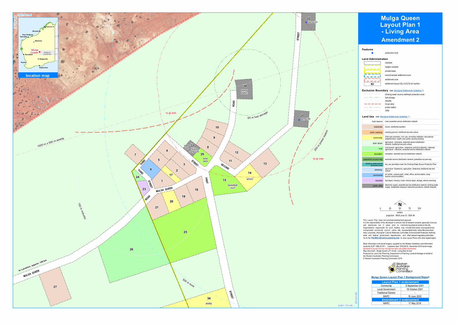
Land Administrationcad astrelod g ed c ad astreprivate leaserecom m end ed settlement zonesettlem ent zonesettlem ent layou t (SL) lot & SL-lot nu m ber63
electric ity su pply, essential service d istribu tion network, d rinking watersu pply, wastewater d isposal, telecom m u nic ations, ru bbish d isposalpu blic u tility
fu el depot, ind u stry, m otor veh ic le repair, storag e, veh ic le wrec kingind u strial
art centre, c aravan park, m otel, office, service station, sh op,tou rism ac c om m od ationcom m erc ial
essential service d istribu tion network, pedestrian ac cess waypedestrian ac cess way
recreation, essential service d istribu tion networkrecreation
ru ral pu rsu it, ag ric u ltu re - extensive, anim al h u sband ry - intensive,ag ric u ltu re - intensive, essential service d istribu tion networkru ral
c h ild care prem ises, c ivic u se, corrective institu tion, ed u c ationalestablish ment, health c are centre, worsh ip bu ild ingcom m u nityag ric u ltu re - extensive, essential service d istribu tionnetwork, trad itional law and c u ltu reopen space
cam ping g rou nd, trad itional law and c u ltu revisitor c am ping
h ou se, residential qu artersresid ential
road, essential service d istribu tion networkroad reserve
any u se perm itted u nder the Drinking Water Sou rce P rotec tion P land rinking water sou rceprotec tion area
Land Use (see Aborig inal Settlements Gu id eline 1)
ag ric u ltu re – extensive, ag ric u ltu re – intensive, trad itional law andc u ltu rewaterway
Go to the
Th is Layou t P lan d oes not c onstitu te developm ent approval.It is the responsibility of the developer to ensu re th at all relevant c onsents, approvals, licencesand clearances are in place prior to c om m enc ing physic al works on the site.Org anisations responsible for su c h m atters m ay inc lu de land owner, loc al g overnm ent,inc orporated com m u nity cou nc il, native title representative body, native title presc ribedbody c orporate, Aborig inal Cu ltu ral Materials Com m ittee, Environm ental P rotec tion Au th ority,state and federal g overnm ent departm ents, and other relevant reg u latory au th orities.
PlanWA interactive planning map to view Layou t P lans with other spatial layers.
Featuresprod u c tion bore!
Exclusion Boundaryd rinking water sou rce wellhead protec tion zonefu el storag eind u stryno-g o areapower stationu tility
(see Aborig inal Settlements Gu id eline 3)
!
!
26
25
27
34
15
3 13
1
9
142
8
7
21
6
4
5
18
30
1920
12
32
31
10
1129
33
23
1724
1000 m x 500 m airstrip
200m po
wersta
tion
150 m industry
85 m fuel storage
500 m bore
airstrip
no g o area
no g o area
sc h ool
bore 1/91
bore 2/90
watertank
solarpac k
powerstation
basketballcou rt
Telstracom pou nd
ROAD
FIRST
STRE
ET
THIRD
SECOND
MULGA QUEEN
STREET
STREET
ROAD
STREETTHIRD
MULGA QUEEN
404,923 mE
6,951,930 mN
6,951,172 mN
405,810 mE
Perth
Broome
Karratha
Geraldton
Port Hedland
Kalgoorlie
Kununurra
Newman
Esperance
NT
SASHIRE OF
LAVERTON
location map
MulgaQueen
to Laverton, approx. 140 km
Com m u nity
Trad itional OwnersWAP C
8 Septem ber 2001Local Governm ent 18 October 2001
-18 Ju ne 2002
Layout Plan 1 endorsement
WAP C 17 May 2016Amendment 2 endorsement
Mulga QueenLayout Plan 1- Living AreaAmendment 2

proje ction : MGA zone 51, GDA 94
Base inform ation and ae rial im age ry supplie d by th e We ste rn Australian Land Inform ationAuth ority SLIP 1096-2018-1. Cadastre date 15/02/2019. Dece m be r 2018 ae rial im age.Map docum e nt : Mulga Q ue e n LP1 Am d2 - Context v2.m xdProd uce d by Land Use Planning, De partm e nt of Planning, Land s & He ritage on be h alf ofth e We ste rn Australian Planning Com m ission.© We ste rn Australian Planning Com m ission 2019
Se ttle m e nt layout lots are not d e riv e d from calculate d d im e nsions.
N0 50 100 150 200 250
m e tre s
Land Administrationcadastrelod ge d cadastreprivate le asere com m e nd e d se ttle m e nt zonese ttle m e nt zonese ttle m e nt layout (SL) lot & SL-lot num be r63
Go to th e
Th is Layout Plan d oe s not constitute d e v e lopm e nt approval.It is th e re sponsibility of th e d e v e lope r to e nsure th at all re le vant conse nts, approvals, lice nce sand clearance s are in place prior to com m e ncing ph ysical work s on th e site.Organisations re sponsible for such m atte rs m ay includ e land owne r, local gove rnm e nt,incorporate d com m unity council, nativ e title re pre se ntativ e body, nativ e title pre scribe dbody corporate , Aboriginal Cultural Mate rials Com m itte e, Environm e ntal Protection Auth ority,state and fe d e ral gov e rnm e nt d e partm e nts, and oth e r re le vant regulatory auth oritie s.
PlanWA interactive planning map to v ie w Layout Plans with oth e r spatial laye rs.
Featuresprod uction bore!
e lectricity supply, e sse ntial se rv ice d istribution ne twork, d rink ing wate rsupply, wastewate r d isposal, te lecom m unications, rubbish d isposalpublic utility
fue l d e pot, ind ustry, m otor v e h icle re pair, storage, ve h icle wreck ingind ustrial
art ce ntre, caravan park , mote l, office, se rv ice station, sh op,tourism accom m odationcom m e rcial
esse ntial se rv ice d istribution ne twork, pe d e strian acce ss waype d e strian acce ss way
recreation, e sse ntial se rv ice d istribution ne tworkre cre ation
rural pursuit, agriculture - exte nsiv e , anim al h usband ry - inte nsiv e ,agriculture - inte nsiv e , e sse ntial se rv ice d istribution ne tworkrural
ch ild care pre m ise s, civ ic use, correctiv e institution, e d ucationalestablish m e nt, h ealth care ce ntre, worsh ip build ingcom m unityagriculture - exte nsiv e , e sse ntial se rv ice d istributionne twork, trad itional law and cultureope n space
cam ping ground, trad itional law and culturev isitor cam ping
house, re sid e ntial quarte rsre sid e ntial
road, e sse ntial se rv ice d istribution ne tworkroad re se rv e
any use pe rm itte d und e r th e Drink ing Wate r Source Protection Pland rink ing wate r sourceprotection areaagriculture – extensiv e , agriculture – inte nsiv e , trad itional law andculturewate rway
Land Use
Exclusion Boundaryd rink ing wate r source we llh e ad prote ction zoneno-go are awastewate r
!
!
1000 m x 500 m airstrip
500 m bore
34
28
airstrip
bore 1/91
bore 2/90
no go area
no go area
rubbishtip
powe rstation
ROAD
FIRST
STRE
ET
SECOND
MULGA QUEENST
REET
404,303 mE
6,952,156 mN
6,950,530 mN
406,204 mE
Perth
Broome
Karratha
Geraldton
Port Hedland
Kalgoorlie
Kununurra
Newman
Esperance
NT
SASHIRE OF
LAVERTON
location map
MulgaQueen
to Laverton, approx. 140 km
Com m unity
Trad itional Owne rsWAPC
8 Se pte m be r 2001Local Gov e rnm e nt 18 Octobe r 2001
-18 June 2002
Layout Plan 1 endorsement
WAPC 17 May 2016Amendment 2 endorsement
Mulga QueenLayout Plan 1
- ContextAmendment 2
projection : MGA zone 51, GDA 94
Base information supplied by the Western Australian Land Information AuthoritySLIP 1096-2018-1. Cadastre date 15/02/2019.
Map document : Mulga Queen LP1 Amd2 - Land Tenure.mxdProduced by Land Use Planning, Department of Planning, Lands & Heritage on behalf ofthe Western Australian Planning Commission.© Western Australian Planning Commission 2019
Settlement layout lots are not derived from calculated dimensions.
N0 100 200 300 400 500
metres
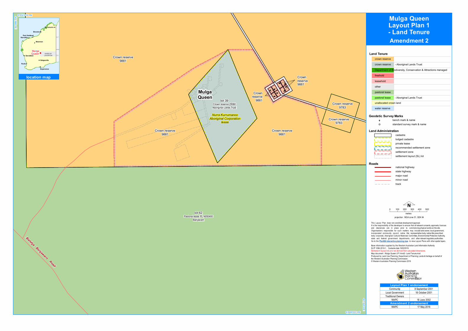
Land Tenurecrown reservecrown reserve - Aboriginal Lands TrustDepartment of Biodiversity, Conservation & Attractions managedfreeholdleaseholdotherpastoral lease
unallocated crown landwater reserve
pastoral lease - Aboriginal Lands Trust
Go to the
This Layout Plan does not constitute development approval.It is the responsibility of the developer to ensure that all relevant consents, approvals, licencesand clearances are in place prior to commencing physical works on the site.Organisations responsible for such matters may include land owner, local government,incorporated community council, native title representative body, native title prescribedbody corporate, Aboriginal Cultural Materials Committee, Environmental Protection Authority,state and federal government departments, and other relevant regulatory authorities.
PlanWA interactive planning map to view Layout Plans with other spatial layers.
Roadsnational highwaystate highwaymajor roadminor roadtrack
Land Administrationcadastrelodged cadastreprivate leaserecommended settlement zonesettlement zonesettlement layout (SL) lot
bench mark & namestandard survey mark & name
Geodetic Survey Marks
.
&—
Crown reserve9881
Crown reserve9881
Crownreserve9881
Crown reserve9881
Crown reserve9783
Crown reserve9783
lot 39Crown reserve 25060Aboriginal Lands Trust
lot 62Pastoral lease PL N050400
Banjawarn
Crownreserve
9881
Bandya - Banjawarn Road
402,868 mE
6,952,618 mN
6,948,553 mN
407,620 mE
Perth
Broome
Karratha
Geraldton
Port Hedland
Kalgoorlie
Kununurra
Newman
Esperance
NT
SASHIRE OF
LAVERTON
location map
MulgaQueen
MulgaQueen
Nurra KurrumanooAboriginal Corporation
lease
Community
Traditional OwnersWAPC
8 September 2001Local Government 18 October 2001
-18 June 2002
Layout Plan 1 endorsement
WAPC 17 May 2016Amendment 2 endorsement
Mulga QueenLayout Plan 1- Land TenureAmendment 2