Embed Size (px)
Citation preview

Page 1 of 6
WWNWS WWNWS3/3/2-XI-Rev1
Meeting 3 31 August 2011
Agenda Item 3.2
MSI Self Assessment NAVAREA XI
Submitted by Japan
1. Background
NAVAREA XI navigational warnings are issued through the POR satellite and (or)
the IOR satellite INMARSAT.
Broadcast schedules:
(1) Routine broadcast times (UTC): 0005, 0805 and 1205.
(2) Details of transmission.
(a) Broadcasts is made at nearest the next routine time after reception of the
information and thereafter repeated at the same time each day for 6weeks.
(b) NAVAREA XI Navigational Warnings Bulletin listing the numbers of in force
warnings issued during the last 6weeks is broadcasted at 1205 UTC on every
Saturday.
(c) Important message is broadcasted immediately and is repeated once a day on
routine time.
NAVAREA XI is bounded by the lines commencing following geographical positions:
a) On the coast (Russian-North Korean border)
b) 42-17.5N 135-00E
c) 45-00N 138-20E
d) 45-00N 180-00E
e) 00-00N 180-00E
f) 00-00N 141-00E
g) 10-00S 141-00E
h) 10-00S 127-00E
i) 12-00S 127-00E
j) 12-00S 095-00E
k) 06-00N 095-00E
l) 098-00E on the coast (Myanmar-Thailand border)
Safety NET Satellite broadcast service provider: KDDI
Operational Points of Contact for National Co-ordinators within the NAVAREA
COUNTRY TELEPHONE FACSIMILE EMAIL
China +86-10-65293262 +86-10-65293269 [email protected]
SUMMARY
Executive Summary: NAVAREA XI provides the paper of MSI Self Assessment for
WWNWS3
Action to be taken: paragrah12
Related documents: None

Page 2 of 6
Korea (D.P.R of) +850 2 3818888 +850 2 3814692 [email protected]
Korea(R of) +82-32-8800570~2 +82-32-8853088 [email protected]
Indonesia +62-21-64714809,10,19 +62-21-64714809,19 [email protected]
Japan +81-3-3541-3817 +81-3-3542-7174 [email protected]
Malaysia +60-33-1694545,4400 +60-33-1013111 [email protected]
Philippines +63-2-2413494,22955 +63-2-2422090 [email protected]
Singapore +65-63-751562,75,600 +65-62-759247,87646 [email protected]
Thailand +66-2-613369, 4753369 +66-2-1736570 [email protected]
U.S.A (Guam) +1-301-2277407 +1-705-3396210 [email protected]
Vietnam :+84-31-3551817,0685 :+84-31-3550797 [email protected]
2. Comments:
GMDSS Master Plan was the last up date on February, 2011
The following table shows the number of Navigational Warnings that were transmitted on
Safety NET during the past three years.
2008 2009 2010
NAVAREA XI 792 879 1,006
3. NAVTEX Coverage:
(1) International NAVTEX Service
Coast Station Position Coverage
(Mile)
Identification
Character Transmission Time(UTC)
China
Sanya
Guangzhou
Fuzhou
Shanghai
Dalian
18-14N 109-30E
23-08N 113-32E
26-01N 119-18E
31-08N 121-33E
38-52N 121-31E
250
M
N
O
Q
R
0200 0600 1000 1400 1800 2200
0210 0610 1010 1410 1810 2210
0220 0620 1020 1420 1820 2220
0240 0640 1040 1440 1840 2240
0250 0650 1050 1450 1850 2250
Hongkong 22-13N 114-15E 400 L 0150 0550 0950 1350 1750 2150
Korea (D.P.R of)
Pyongyang
Hamhung
38-55N 125-43E
39-50N 127-42E
200
D
E
0030 0430 0830 1230 1630 2030
0040 0440 0840 1240 1640 2040
Korea(R of)
Jukbyeon
Byeonsan
37-03N 129-26E
35-36N 126-29E
150
V
W
0330 0730 1130 1530 1930 2330
0340 0740 1140 1540 1940 2340
Indonesia
Jayapura
Ambon
Makassar
Jakarta
02-31S 140-43E
03-42S 128-12E
05-06S 119-26E
06-06S 106-54E
300
A
B
D
E
0000 0400 0800 1200 1600 2000
0010 0410 0810 1210 1610 2010
0030 0430 0830 1230 1630 2030
0040 0440 0840 1240 1640 2040
Japan
Kushiro
Otaru
Yokohama
Moji
Naha
42-57N 144-36E
43-19N 140-27E
35-14N 139-55E
34-01N 130-56E
26-05N 127-40E
400
K
J
I
H
G
0140 0540 0940 1340 1740 2140
0130 0530 0930 1330 1730 2130
0120 0520 0920 1320 1720 2120
0110 0510 0910 1310 1710 2110
0100 0500 0900 1300 1700 2100
Malaysia
Penang
Miri
Sandakan
05-26N 100-24E
04-28N 114-01E
05-54N 118-00E
350
U
T
S
0320 0720 1120 1520 1920 2320
0310 0710 1110 1510 1910 2310
0300 0700 1100 1500 1900 2300

Page 3 of 6
Singapore
Singapore
01-20N 103-59E
400
C
0020 0420 0820 1220 1620 2020
Thailand
Bangkok
13-34N 100-39E
200
F
0050 0450 0850 1250 1650 2050
Taiwan
Keelung
Linyuan
25-08N 121-45E
22-29N 120-25E
540
P
P
0630 1430 2230
0230 1030 1830
United States
Guam
13-29N 144-50E
200
V
0100 0500 0900 1300 1700 2100
Vietnam
Ho Chi Minh
Da Nang
10-45N 106-43E
16-03N 108-41E 400
X
K
0350 0750 1150 1550 1950 2350
0230 0630 1030 1430 1830 2230
Trial Station Philippines
Manila
14-30N 121-04E 300
J
0130 0530 0930 1330 1730 2130
Planned Philippines
Davao
07-05N 125-36E
300
R
0250 0650 1050 1250 1850 2250
(2) National NAVTEX Service (490 kHz or 4209.5 kHz)
Country/Language
Coast Station Position
Coverage
(Mile)
Identification
Character Transmission Time(UTC)
Korea (D.P.R of) / Korean
Pyongyang
Hamhung
490kHz
38-55N 125-43E
39-50N 127-42E
200
A
B
0000 0400 0800 1200 1600 2000
0010 0410 0810 1210 1610 2010
Korea (R of) / Korean
Jukbyeon
Byeonsan
490kHz
37-03N 129-26E
35-36N 126-29E
150
J
K
0130 0530 0930 1330 1730 2130
0230 0630 1030 1430 1830 2230
Vietnam / English
Hai Phong
4209.5kHz
20-52N 106-41E
400
W
0340 1540
(3) National NAVTEX Service (Other frequencies)
Country/Language
Coast Station
Frequencies
Position Coverage
(Mile)
Identification
Character Transmission Time(UTC)
Japan / Japanease
Kushiro
Otaru
Yokohama
Moji
Naha
424kHz
42-57N 144-36E
43-19N 140-27E
35-14N 139-55E
34-01N 130-56E
26-05N 127-40E
400
K
J
I
H
G
0108 0508 0908 1308 1708 2108
0051 0451 0851 1251 1651 2051
0034 0434 0834 1234 1634 2034
0017 0417 0817 1217 1617 2017
0000 0400 0800 1200 1600 2000
Trial Station China / Chinese
Sanya
Zhanjiang
Guangzhou
Fuzhou
Shanghai
Tianjin
Dalian
486kHz
18-14N 109-30E
No Information
23-08N 113-32E
26-01N 119-18E
31-08N 121-33E
No Information
38-52N 121-31E
250
M
Z
N
O
Q
T
R
0100 0500 0900 1300 1700 2100
0020 0420 0820 1220 1620 2020
0000 0400 0800 1200 1600 2000
0120 0520 0920 1320 1720 2120
0140 0540 0940 1340 1740 2140
0020 0420 0820 1220 1620 2020
0250 0650 1050 1450 1850 2250
Page 4 of 6
4. Operational Issues
None
5. Quality Management Survey
NAVAREA
ISO
9001
-
2000
Promulgate
“In-Force”
Bulletins
Promulgate
“No-
Warning”
Messages
Monitor
Broadcast
in almost
real time
24/7 contact
information
provided
Promulgate
two
scheduled
broadcasts
IMO
Master
Plan
updated
XI NO YES NO YES YES YES YES
6. Contingency Planning
When a trouble occur in the system to issue navigational warnings, NAVAREA XI
Co-ordinator will send a Navigational Warning message to LES(Land Earth Station) by
facsimile. The operator of the LES will type the message, and broadcast it for each ship.
7. Capacity Building:
None
8. Other Activities:
(1) NAVAREA XI Regional Conference on World-Wide Navigational Warnings was
held in Tokyo, Japan in October 2010.
The meeting was attended by representatives from 9 countries within NAVAREA XI
region. It was also attended adjacent region, NAVAREA VIII Coordinator and
WWNWS (Vice- Chairman).
NAVAREA XI
A
B
C
D E
F
G
H I
J
K
L
M
N
O P
P
Q
R
S T U
V
V
W
X
●
●
● ●
●
●
●
●
●
● ●
● ●
●
●
●
●
●
●
● ●
● K
● ●
● ●
International NAVTEX stations in NAVAREA XI
Operational(29 stations、A to X)
Boundary of
NAVAREA XI
●
●
●
E D
J(Trial) ●
● R
(Planed)
B1
A Jayapura
B Ambon
C Singapore
D Makassar Pyongyang
E Jakarta Hamhung
F Bangkok
G Naha
H Moji
I Yokohama
J Otaru Manila
K Kushiro Da Nang
L Hong Kong
M Sanya
N Guangzhou
O Fuzhou
P Keelung Linyuan
Q Shanghai
R Dalian Davao
S Sandakan
T Miri
U Penang
V Jukbyeon Guam
W Byeonsan
X Ho Chi Minh
Coast Station

Page 5 of 6
Information was exchange between attending countries and the issue of overlaying
of navigational warnings in ECDIS was discussed at the conference.
(2) Immediately after the Great East Japan Earthquake, the Japan Hydrograohic and
Oceanographic Department (JHOD) issued navigational warnings on the earthquake
occurrence and tsunami to ships in the neighbouring region.
We issued navigational warnings on aids to navigation, such as loss of light in the
lighthouses, dislocation of buoys, and on floating debris and ships, one after another.
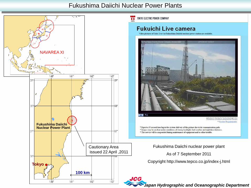
We promulgated the vessels at sea about news of the emergency events such as the
explosion at Fukushima Daiichi nuclear power plant, by issuing navigational warnings.
And, when we received the instruction from the government to take shelter inside or to
set the cautionary area, due to the released radioactive materials from the nuclear power
plant, we also promulgated the vessels at sea of the same information.
In addition, as the number of information to be dealt with navigational warnings had
greatly increased, it was clear that the number would exceed the capacity of the “B”
character of the NAVTEX system. Therefore, concerning navigational warnings on
drifting hazards, we decided to issue navigational warnings once a day representing the
area which included their positions.
9. NAVAREA Website:
Web sit: http://www1.kaiho.mlit.go.jp/TUHO/tuho/html/tuho/keiho_eg.html
Update at any time.
10. NAVAREA Contact Information:
[NAVAREA XI]
Capt. Hiroyuki Tanaka
Director,
Notices to Mariners Office Hydrographic and Oceanographic Department
Japan Coast Guard
3-1, Tsukiji 5-chome Chuo-ku TOKYO 104-0045
Tel: +81 (3) 3541 3817
Fax: +81 (3) 3542 7174
E-mail: [email protected]
Japan Hydrographic and Oceanographic Department will move about December,
2011
Details will be informed as soon as the date of the move is decided.
11. Recommendations:
None
12. Actions requested:
The Sub-committee is invited to note the report.
13. Synopsis:
(1) NAVAREA XI Regional Conference on World-Wide Navigational Warnings was
held in Tokyo, Japan in October 2010.
Page 6 of 6
The meeting was attended by representatives from 9 countries within NAVAREA XI
region. It was also attended adjacent region, NAVAREA VIII Coordinator and
WWNWS (Vice- Chairman).
Information was exchanged between attending countries and the issue of overlaying
of navigational warnings in ECDIS was discussed at the conference.
(2) Immediately after the Great East Japan Earthquake, the Japan Hydrograohic and
Oceanographic Department (JHOD) issued navigational warnings on the earthquake
occurrence and tsunami to ships in the neighbouring region.
We issued navigational warnings on aids to navigation, such as loss of light in the
lighthouses, dislocation of buoys, and on floating debris and ships, one after another.
We promulgated the vessels at sea about news of the emergency events such as the
explosion at Fukushima Daiichi nuclear power plant, by issuing navigational warnings.
And, when we received the instruction from the government to take shelter inside or to
set the cautionary area, due to the released radioactive materials from the nuclear power
plant, we also promulgated the vessels at sea of the same information.
In addition, as the number of information to be dealt with navigational warnings had
greatly increased, it was clear that the number would exceed the capacity of the “B”
character of the NAVTEX system. Therefore, concerning navigational warnings on
drifting hazards, we decided to issue navigational warnings once a day representing the
area which included their positions. (3) Japan Hydrographic and Oceanographic Department will move about December,
2011
Hydrographic and Oceanographic Department
13-16 September, 2011
JAPAN COAST GUARD
MSI Self Assessment NAVAREA XI
Related Paragraph 8 Other Activities
WWNWS3/3/2-XI-Rev1

Hachinohe
Miyako Kamaishi
Kesennuma
Shiogama Sendai
Onahama
Fukushima Daiichi Nuclear Power Plant
Tokyo
Osaka
Pacific Ocean
source region
M7.4
M9.0
M7.7
Japan Sea
M7.5
Ofunato
Kuji
Okinawa
Tokyo
Sapporo
Pacific Ocean
Japan Sea
100 km
Occurrence of Earthquake
14:46
March 11, 2011
05:46Z 11 March, 2011
Magnitude 9.0
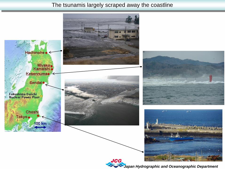
The tsunamis largely scraped away the coastline
Japan Hydrographic and Oceanographic Department

Damage due to the Earthquake and Tsunami
Japan Hydrographic and Oceanographic Department
Damaged Light
Adrift House and Objects
Strange C/V
Adrift Crane Barge

Drifting hazards
100km

Drifting hazards –Issuing Navigational Warnings-
NAVTEX 11-0907
HOUSHU, E COAST. SE OF KUJI WAN TO N OF
INUBO SAKI.
NUMEROUS VESSELS AND OBJECTS,
CONTAINED A PART OF HOUSE ADRIFT W OF
LINE JOINING.
40-07.3N 142-03.4E 38-05.0N 143-11.1E
37-38.1N 142-41.8E 36-49.0N 142-17.0E
36-22.1N 142-49.4E 36-13.0N 140-56.2E
AT 250700Z MAR
CANCEL 0899/11
NAVTEX 11-0908
HOUSHU, E COAST. N OF HACHINOHE KO TO
OF INUBO SAKI.
NUMEROUS VESSELS AND OBJECTS ADRIFT.
A. IN VICINITY OF 40-35.2N 141-31.3E
B. IN VICINITY OF LINE JOING
39-20.0N 143-20.0E 39-20.0N 143-30.0E
39-17.6N 143-33.3E
C. WITHIN 10 MILES OF
38-25.0N 143-05.0E.
D. AREA BOUNDED BY
37-00.0N 143-04.5E 37-03.6N 143-34.8E
36-43.2N 144.14.0E 36-33.7N 143-32.5E
E. IN VINCINITY OF LINE BETWEEN
36-01.5N 145-25.3E AND 35-58.0N 145-18.6E.
AT 250700Z MAR
CANCEL 0900/11
100km
A
B
C
D
E
NAVAREA XI
Japan Hydrographic and Oceanographic Department
Fukushima Daiichi Nuclear Power Plants
Fukushima Daiichi nuclear power plant
As of 7 September 2011
Copyright http://www.tepco.co.jp/index-j.html
100 km
Tokyo
Fukushima Daiichi Nuclear Power Plant
Cautionary Area
issued 22 April ,2011

Thank you for your attention.
Japan Hydrographic and Oceanographic Department
Against the Great East Japan Earthquake - Issuing Navigational Warnings-