Embed Size (px)
Citation preview

mountain biking
Trail Rating
Visitor Information Centre 301 Victoria Road W.250-837-5345 / 1-800-487-1493
Parks & Recreation: 250-837-9351BC Ministry of Forests: 250-837-7611Parks Canada: 250-837-7500Revelstoke Cycling Association (RCA):www.BikeRevelstoke.org
These trails are in working forests. Check for trail updates on the RCA’s website.
Offering 40km of classic Revelstoke singletrack, inter-connected with logging roads, there are endless variations of link-ups appealing to all difficulty levels. These trails are provincial recreation trails operated by the Revelstoke Cycling Association in partnership with Recreation Sites and Trails BC.
Access from downtown Revelstoke: -Head West on 3rd St, left on Charles St-Right on Douglas, Left on Wilson, cross the Big Eddy Bridge -Continue along Big Eddy Rd, left on Hwy 23 S to trailheads- Trailhead distance from Hwy 1 and Hwy 23 S junction:
TRAILHEAD DISTANCE CYCLE TIME (from downtown)Tantrum 2.0km 15 minutesFlowdown Lot 2.8km 20 minutesGriffith Creek FSR Lot 5.3km 25 minutesMt Macpherson Lot 7.3km 35 minutesBegbie Bluffs Lot 8.9km 40 minutes
Easy More Difficult Very Difficult Extremely Difficult
@SeeRevelstoke | #TheRealStokewww.SeeRevelstoke.com
Frisby
Boulder
Keystone
Martha Creek
Mt. Revelstoke NP
Revelstoke
Macpherson
Cartier
Tranquility Traverse 0.3 Old double track
Forest Lane 0.5 Old double track
Telemarker’s Choice 0.6 Wide, steep climb
Toad School 0.8 Short & friendly
Dusty Beaver 1.4 Flowy, rock sections
Stimulus 4.7 Flowy, rock sections, bridges
Tight Rope 0.4 Steep sidehill – look ahead!
Mad Man’s Step 0.3 Flat connecter trail
Flowdown 5.7 Flowy w/ rock sections
Hemlock Groove 1.6 Fast, flowy, rock sections
Yew R Here 0.9 Fast, flowy, rock sections
Dog Patch 1.1 Friendly grade
River Run 1.3 Rooty, can be muddy
Berm Donor 2.2 Fast downhill, tough climb
Black Forest 1.9 Rooty, lots of variety
Sloe Grin 1.2 Rocky, technical climbs
Break-a-Leg 0.9 Fun DH, technical climb
Buff Enough 1.2 Great view, challenging climb
Lookout 1.1 Tight tech sections, rock slab
Root Canal 0.7 Very rooty, fun
TNT 1.7 Fast DH, tough climb
Tantrum 5.0 Lots of variety & challenges
Quarry 2.7 Steep, tech, fast DH, rooty
Richard Liqueur 0.8 Steep sections, rooty
View 1.4 Steep, non-technical grade
Bluff 2.0 Fast w/ tech sections
Ridge Walk 1.5 Steep climbs, access to TNT
4 Play 0.8 Steep climbs, fast transitions
Sex on the Beach 2.6 Tech sections, steep climbs
Backside 1.3 Rocky, tech, best N to S
Dog Patch Direct 0.4 Steep, wet sections, Best W to E
Super Happy Fun 0.7 Downhill, S to N only
Chair 0.1 Downhill, S to N onlyUp-to-date trail conditions & a trail map GPS enabled app is available for download at: bikerevelstoke.org
Guided Trips & Tours | All-Inclusive Vacations Camps & Clinics | Heli-Biking | Shuttles
WANDERINGWHEELS.CA | 1.250.814.7609
BRITISH COLUMBIA, CANADA
Trail Name Length(km) Character
Cross Country Trails
more information
WILDLIFE - Do not approach
ETIQUETTE - Wheels yield to heels
SHARE - Uphill rider has right of way
PETS - Clean up and keep in control
ENVIRONMENT - Stay on the trail
EROSION - Ride don’t slide!
TRAIL CLOSURES - Respect them!
TRASH - Leave no trace
Link ‘Em Up!
Scan here forloop suggestions
bike trail locations
XC RESPECT
Mount Macpherson Recreation Trails (right)
Mount MacPherson Recreation Trails
In Partnership with:Managed by: In partnership with:
BRITISH COLUMBIA, CANADA
****
Downhill Mountain Biking
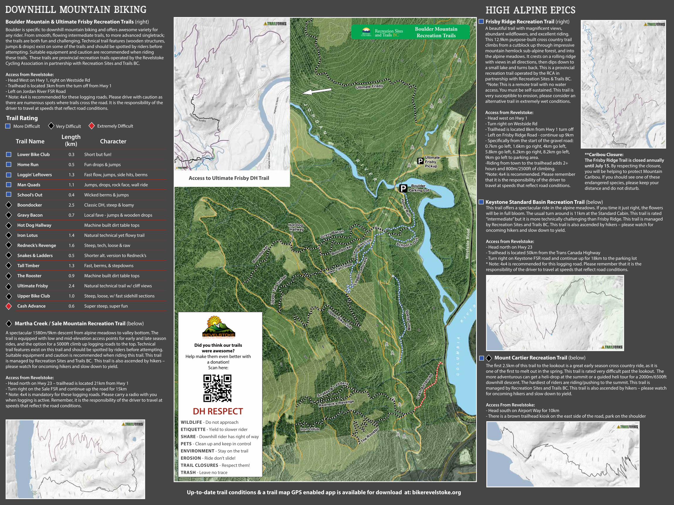
Boulder is specific to downhill mountain biking and offers awesome variety for any rider. From smooth, flowing intermediate trails, to more advanced singletrack; the trails are both fun and challenging. Technical trail features (wooden structures, jumps & drops) exist on some of the trails and should be spotted by riders before attempting. Suitable equipment and caution are recommended when riding these trails. These trails are provincial recreation trails operated by the Revelstoke Cycling Association in partnership with Recreation Sites and Trails BC.
Access from Revelstoke: - Head West on Hwy 1, right on Westside Rd- Trailhead is located 3km from the turn off from Hwy 1- Left on Jordan River FSR Road* Note: 4x4 is recommended for these logging roads. Please drive with caution as there are numerous spots where trails cross the road. It is the responsibility of the driver to travel at speeds that reflect road conditions.
More Difficult Very Difficult Extremely Difficult
A spectacular 1580m/9km descent from alpine meadows to valley bottom. The trail is equipped with low and mid-elevation access points for early and late season rides, and the option for a 5000ft climb up logging roads to the top. Technical trail features exist on this trail and should be spotted by riders before attempting. Suitable equipment and caution is recommended when riding this trail. This trail is managed by Recreation Sites and Trails BC. This trail is also ascended by hikers – please watch for oncoming hikers and slow down to yield.
Access from Revelstoke: - Head north on Hwy 23 – trailhead is located 21km from Hwy 1- Turn right on the Sale FSR and continue up the road for 15km* Note: 4x4 is mandatory for these logging roads. Please carry a radio with you when logging is active. Remember, it is the responsibility of the driver to travel at speeds that reflect the road conditions.
A beautiful trail with magnificent views, abundant wildflowers, and excellent riding. This 12.9km purpose-built cross country trail climbs from a cutblock up through impressive mountain hemlock sub-alpine forest, and into the alpine meadows. It crests on a rolling ridge with views in all directions, then dips down to a small lake and turns back. This is a provincial recreation trail operated by the RCA in partnership with Recreation Sites & Trails BC. *Note: This is a remote trail with no water access. You must be self-sustained. This trail is very susceptible to erosion, please consider an alternative trail in extremely wet conditions.
Access from Revelstoke: - Head west on Hwy 1- Turn right on Westside Rd- Trailhead is located 8km from Hwy 1 turn off - Left on Frisby Ridge Road - continue up 9km- Specifically from the start of the gravel road: 0.7km go left, 1.6km go right, 4km go left, 5.8km go left, 6.2km go right, 8.2km go left, 9km go left to parking area. -Riding from town to the trailhead adds 2+ hours and 800m/2500ft of climbing.*Note: 4x4 is recommended. Please remember that it is the responsibility of the driver to travel at speeds that reflect road conditions.
**Caribou Closure: The Frisby Ridge Trail is closed annually until July 15. By respecting the closure, you will be helping to protect Mountain Caribou. If you should see one of these endangered species, please keep your distance and do not disturb.
This trail offers a spectacular ride in the alpine meadows. If you time it just right, the flowers will be in full bloom. The usual turn around is 11km at the Standard Cabin. This trail is rated “intermediate” but it is more technically challenging than Frisby Ridge. This trail is managed by Recreation Sites and Trails BC. This trail is also ascended by hikers – please watch for oncoming hikers and slow down to yield.
Access from Revelstoke: - Head north on Hwy 23- Trailhead is located 50km from the Trans Canada Highway- Turn right on Keystone FSR road and continue up for 18km to the parking lot* Note: 4x4 is recommended for this logging road. Please remember that it is the responsibility of the driver to travel at speeds that reflect road conditions.
The first 2.5km of this trail to the lookout is a great early season cross country ride, as it is one of the first to melt out in the spring. This trail is rated very difficult past the lookout. The more adventurous can get a heli-drop at the summit or a guided heli tour for a 2000m/6500ft downhill descent. The hardiest of riders are riding/pushing to the summit. This trail is managed by Recreation Sites and Trails BC. This trail is also ascended by hikers – please watch for oncoming hikers and slow down to yield.
Access From Revelstoke: - Head south on Airport Way for 10km - There is a brown trailhead kiosk on the east side of the road, park on the shoulder
DH RESPECT WILDLIFE - Do not approach
ETIQUETTE - Yield to slower rider
SHARE - Downhill rider has right of way
PETS - Clean up and keep in control
ENVIRONMENT - Stay on the trail
EROSION - Ride don’t slide!
TRAIL CLOSURES - Respect them!
TRASH - Leave no trace
Did you think our trailswere awesome?
Help make them even better with a donation!Scan here:
Trail NameLength
(km) Character
Trail Rating
Martha Creek / Sale Mountain Recreation Trail (below)
Boulder Mountain & Ultimate Frisby Recreation Trails (right)
high alpine epicsFrisby Ridge Recreation Trail (right)
Keystone Standard Basin Recreation Trail (below)
Mount Cartier Recreation Trail (below)
Access to Ultimate Frisby DH Trail
Up-to-date trail conditions & a trail map GPS enabled app is available for download at: bikerevelstoke.org
Lower Bike Club 0.3 Short but fun!
Home Run 0.5 Fun drops & jumps
Loggin’ Leftovers 1.3 Fast flow, jumps, side hits, berms
Man Quads 1.1 Jumps, drops, rock face, wall ride
School’s Out 0.4 Wicked berms & jumps
Boondocker 2.5 Classic DH, steep & loamy
Gravy Bacon 0.7 Local fave - jumps & wooden drops
Hot Dog Hallway Machine built dirt table tops
Iron Lotus 1.4 Natural technical yet flowy trail
Redneck’s Revenge 1.6 Steep, tech, loose & raw
Snakes & Ladders 0.5 Shorter alt. version to Redneck’s
Tall Timber 1.3 Fast, berms, & stepdowns
The Rooster 0.9 Machine built dirt table tops
Ultimate Frisby 2.4 Natural technical trail w/ cliff views
Upper Bike Club 1.0 Steep, loose, w/ fast sidehill sections
Cash Advance 0.6 Super steep, super fun