Embed Size (px)
Citation preview

MORNINGTON SAFE BOAT HARBOUR PROJECT
ASSESSMENT
under
ENVIRONMENT EFFECTS ACT 1978
Minister for Planning
December 2011

GLOSSARY
AAV Aboriginal Affairs Victoria
CHMP Cultural Heritage Management Plan, prepared under Aboriginal Heritage Act 2006
DPCD Victorian Department of Planning and Community Development
DSE Victorian Department of Sustainability and Environment
EES Environment Effects Statement
EMP Environmental Management Plan
EMS Environmental Management System
EPA Victorian Environment Protection Authority
EPBC Act Environment Protection and Biodiversity Conservation Act 1999
ERC Environmental Review Committee
ESD ecologically sustainable development
EVC Ecological Vegetation Class
FFG Act Flora and Fauna Guarantee Act 1988 (Vic.)
GHG Greenhouse Gases
ha hectares
IGAE Inter-Governmental Agreement on the Environment
LPPF Local Planning Policy Framework
m, m3 metres, cubic metres
NVMF Victoria’s Native Vegetation Management Framework
P&E Act Planning and Environment Act 1987
SEPPs State Environment Protection Policies
SPPF State Planning Policy Framework

ii
TABLE OF CONTENTS
1 Introduction .............................................................................................................................. 1
1.1 Purpose of this document ....................................................................................................... 1
1.2 Project description .................................................................................................................. 1
1.3 Project History......................................................................................................................... 2
1.4 Structure of this Assessment .................................................................................................. 2
2 Statutory Processes ................................................................................................................. 4
2.1 Environment Effects Act 1978 ................................................................................................. 4
2.2 Statutory Approvals ................................................................................................................. 4
3 Environmental Assessment .................................................................................................... 5
3.1 Approach to this Assessment ................................................................................................. 5
3.2 Project Benefits..................................................................................................................... 7
3.2.1 Provision of a Safe Boat Harbour ....................................................................................... 8
3.2.2 Community or Public Benefit ............................................................................................... 9
3.2.3 Business Case .................................................................................................................. 11
3.2.4 Conclusions ...................................................................................................................... 12
3.3 Marine and Coastal Environment ...................................................................................... 13
3.3.1 Physical Coastal Processes .............................................................................................. 13
3.3.2 Water Quality .................................................................................................................... 14
3.3.3 Marine Ecology ................................................................................................................. 15
3.3.4 Conclusions ...................................................................................................................... 16
3.4 Visual and Landscape Values ............................................................................................ 17
3.4.1 Conclusions ...................................................................................................................... 19
3.5 Public Use of Water, Land and Community Infrastructure ............................................. 19
3.5.1 Community Infrastructure, Recreation and Tourism ......................................................... 20
3.5.2 Public Health and Safety ................................................................................................... 21
3.5.3 Conclusions ...................................................................................................................... 21
3.6 Amenity and Other Effects ................................................................................................. 22
3.6.1 Noise ................................................................................................................................. 23
3.6.2 Traffic and Parking ............................................................................................................ 23
3.6.3 Greenhouse Gas Emissions ............................................................................................. 24
3.6.4 Conclusions ...................................................................................................................... 24
3.7 Cultural Heritage ................................................................................................................. 25
3.7.1 Aboriginal Cultural Heritage .............................................................................................. 25
3.7.2 Non-Aboriginal Cultural Heritage ...................................................................................... 25
3.7.3 Conclusions ...................................................................................................................... 26
3.8 Environmental Management .............................................................................................. 26

iii
3.8.1 Proposed Environmental Management ............................................................................. 27
3.8.2 Conclusions ...................................................................................................................... 27
3.9 Ecologically Sustainable Development ............................................................................ 28
3.9.1 Consistency with ESD and Environmental Protection ....................................................... 29
3.9.2 Overall Conclusion ............................................................................................................ 29
4 Response to Inquiry Recommendations .............................................................................. 30
1
1 INTRODUCTION
1.1 Purpose of this document This document is the assessment of environmental effects (“Assessment”) under the Environment Effects Act 1978 (EE Act) for the proposed Mornington Safe Boat Harbour (MSBH) project. It represents the final step in the Environment Effects Statement (EES) process under the EE Act by providing advice to decision-makers on the likely environmental effects of the proposal, their acceptability and how they should be addressed in relevant statutory decisions. The Assessment is largely informed by the Inquiry Report and EES, together with public submissions.
This Assessment will inform the decisions required under Victorian law for the proposal to proceed, in particular approvals under the Planning and Environment Act 1987 (P&E Act), Coastal Management Act 1995 (CM Act), Crown Land (Reserves) Act 1978, and Port Services (Local Ports) Regulations 2004.
1.2 Project description The existing Mornington Harbour is located on the eastern side of Port Phillip Bay, north of the Mornington town centre. The harbour is bounded by Schnapper Point to the west, the historic Mornington Pier and Fisherman’s Jetty to the north-west and Mothers Beach, Scout Beach and Shire Hall Beach to the south. It provides for 60 swing moorings for recreational boats, and 30 additional berths (including fore and aft moorings). The Mornington Yacht Club’s (MYC’s) facilities also include a two lane public boat ramp and car park occupying land to the south-west of the harbour.
Mornington Boat Haven Limited (MBHL), acting on behalf of the MYC , proposes to develop a ‘safe harbour’ and marina at the site of the existing Mornington Harbour near the Mornington township on the east coast of Port Phillip Bay.
The proposed MSBH includes:
a north-west facing wavescreen along the full length of the existing Mornington Pier and a new pier extension (approximately 20 metres in length);
a north facing harbour wavescreen, to be located east of the existing Mornington Pier, approximately 210 metres (m) in length and 7m deep;
a new public jetty parallel to the south of the existing Mornington Pier to provide access to the marina berths and a public walkway and viewing platform above the harbour wavescreen;
approximately 170 floating berths arranged as marina pens, generally orientated in a north-south arrangement;
eight fore and aft moorings to be located south of the third marina arm;
twelve swing moorings to the east of the first, second and third marina arms;
additional ten short-term public berths and ten emergency and police berths along the new public jetty and adjacent areas; and
provision of a disabled access via the low level public jetty.
As part of the development, a number of ancillary facilities are also proposed to enhance the harbour safety and recreational functions, including:
delineated fairways to the public boat ramp and Mornington Pier;
a travel lift to replace the existing slipway; and
re-fuelling and sewage pump-out facilities.
The concept plan of the proposed development is shown on Figure 1 over the page. A detailed project description is provided in the EES (Chapter 2).

2
1.3 Project History
There have been several previous proposals for developing a safe harbour at Mornington. The most recent proposals were in 1987 (GHD-Macknight design based on the Mornington Safe Harbour Feasibility Study report) and in 1990 (concept design from Mornington Boating Facilities Study by Loder & Bayly Consulting Group). The 1990 preferred development concept underwent an EES and in August 1991 an Inquiry under the EE Act provided a positive assessment of the preferred concept. The Inquiry was: “… completely confident that Mornington Harbour can be redeveloped to provide a safe harbour and that any environmental impact can be effectively accommodated in a final concept.”1
Subsequently, the then Minister for Planning issued an Assessment under the EE Act in support of this preferred concept, which made the comment that: “The need for a safe haven (…) seems to be clear (…). What is also clear is that the community of Mornington and elsewhere attaches a high value to the beach area adjacent to the Yacht Club (…) and anything which impinges adversely on the integrity of that will not be accepted easily “2. Indeed in May 1994 the Minister provided advice to the Council that the assessed proposal was not appropriate, in light of further expert advice on coastal processes and water quality provided to the Minister. The Minister wrote to the Mornington Shire President stating that a marina at Mornington was not appropriate and that: “… any future proposal for a marina in the vicinity of Mornington should be outside the Mornington Harbour, and would require an extensive, in-depth, study.”3
The 1990 Mornington Boating Facilities Study also provided a strategic assessment of potential alternative locations for the ‘safe harbour’ in the region. In doing so, it investigated the locations at Royal Beach (northern and western orientations), Linley Point and South of Linley Point. Mornington Harbour was considered the most appropriate location for a ‘safe harbour’ following an examination of potential environmental, social and economic impacts. The preferred development concept for the Harbour assessed in the aforementioned EES was at Mornington. It comprised either a timber jetty or a rock breakwater, which extended past the end of the Mornington Pier by 14m and then turned at a right angle (approximately 150 metres long).
1.4 Structure of this Assessment Section 2 of this Assessment outlines both the EES process and statutory approvals required for the proposed development.
The core part of this Assessment is found in Section 3, which provides findings on the environmental effects of the project and an integrated assessment of the proposal and its acceptability, within the context of the applicable legislation and policy.
Section 4 provides responses to the recommendations of the Inquiry.
1 1991 Panel Report, page 13.
2 Mornington Boating Facilities Development: Assessment of Environmental Effects (August 2003), page 1.
3 The Honourable Robert Maclellan, Minister for Planning, Letter to Mornington Shire President Councillor John Armitage (2 May 1994).
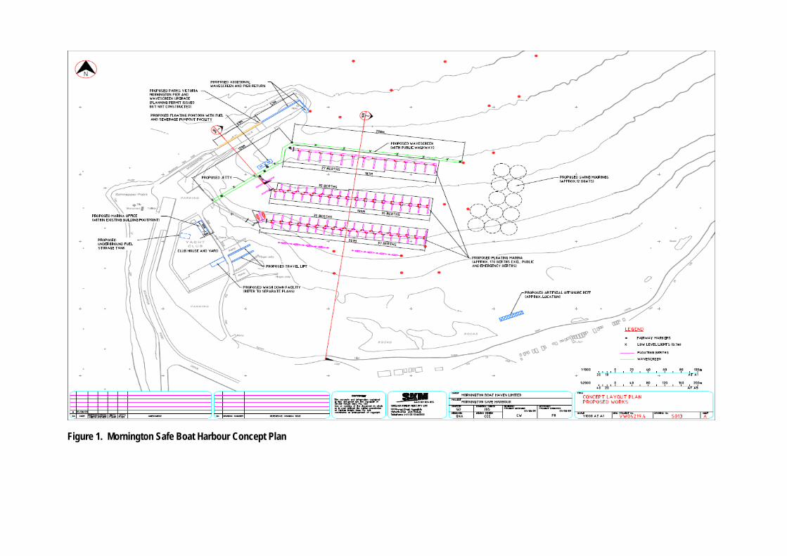
Figure 1. Mornington Safe Boat Harbour Concept Plan
2 STATUTORY PROCESSES
2.1 Environment Effects Act 1978 On 1 August 2005, the then Minister for Planning decided that an EES was required for the MSHP.
In May 2006, the Minister issued Assessment Guidelines that specified the range of matters to be addressed in the EES for the MSBH project.
The EES was prepared by Mornington Safe Haven Limited and then placed on public exhibition from 20 May 2010 until 5 July 2010. Two thousand and eighteen submissions were received, seven of which were from State and local government bodies.
On 19 July 2010, the Minister for Planning appointed an Inquiry under the Environment Effects Act 1978, to review submissions and inquire into the environmental effects of the proposal, in accordance with its terms of reference.
The Inquiry held a first directions hearing on 19 August 2010, followed by a further directions hearing on 12 November 2010. Public hearings were held from 1 February to 10 March 2011.
The Inquiry provided its report to the Minister for Planning on 4 May 2011. The next step under the EE Act is for the Minister for Planning to provide an Assessment of the environmental effects of the MSBH project to decision-makers under Victorian law (i.e. this document). The decision-makers must then consider the Assessment before deciding whether to allow the proposal to proceed.
2.2 Statutory Approvals The proposed MSBH requires a number of statutory approvals, including:
An amendment to the Mornington Peninsula Planning Scheme and associated planning permit under the Planning and Environment Act 1987 (P&E Act) to provide for development of the project infrastructure;
A consent under the Coastal Management Act 1995 (CM Act) for the development of the coastal Crown land and subsequent tenure over this land under Crown Land (Reserves) Act 1978; and
A work authority from the Port Manager under Port Services (Local Ports) Regulations 2004 (section 212) to undertake works or improvements and construct associated infrastructure.
Exhibition of the relevant statutory notices was coordinated so that the following documents were exhibited concurrently at the same locations:
The EES Main Report, Technical Reports and Summary Brochure for the MSHP;
Amendment C107 to the Mornington Peninsula Planning Scheme; and
Planning Permit Application (CP09/005), together with Draft Planning Permit (CP09/005).

5
3 ENVIRONMENTAL ASSESSMENT
3.1 Approach to this Assessment In assessing the environmental effects of the MSBH project relative to its likely benefits, this Assessment under the EE Act takes into account relevant legislation and policy, including applicable provisions, objectives and standards. This legislative and policy framework underpins the consideration of the proposal, its effects and their acceptability, in order to effectively inform statutory approval decisions.
The Ministerial guidelines for assessment of environmental effects under the Environment Effects Act 1978 (Ministerial Guidelines), made under section 10 of the EE Act, specifically require the assessment of the proposal and its effects to be in the context of the principles and objectives of ecologically sustainable development (ESD) and environmental protection. Moreover, applicable legislation, including the P&E Act and Environment Protection Act 1970 (EP Act) incorporate objectives and principles of ESD and environmental protection.
To provide a coherent and integrated structure for this Assessment of environmental effects and likely benefits, the key aspects of relevant legislation, policy and wider ESD considerations have been synthesized into a set of evaluation objectives that are pertinent to the proposed MSBH. A draft set of evaluation objectives was included in the Assessment Guidelines for this EES, which we were used by the proponent and the Inquiry Panel. Table 1 lists the final set of evaluation objectives used throughout this Assessment, together with the set of core legislation that underpins them. Specific aspects of applicable legislation and related policy will be highlighted in the discussion under individual evaluation objectives.

6
Table 1. Assessment Evaluation Objectives
Evaluation Objectives Key Statutes
Project Benefits
To establish a safe boat harbour at Mornington Harbour that will provide enhanced boating facilities and public benefits to the extent practicable, consistent with relevant policy and legislative provisions, in particular the Victorian Coastal Strategy 2008.
CM Act & VCS
Port Services Act 1995
Crown Land (Reserves) Act 1978
Marine and Coastal Environment
To avoid or minimise as far as practicable adverse impacts on coastal processes, including on long-term stability of nearby beaches and adverse impacts on water quality and sediment quality within the vicinity of the harbour.
To avoid or minimise as far as practicable adverse impacts on the marine environment in the area, including its ecology and other protected beneficial uses.
EP Act
CM Act & VCS
Fisheries Act 1995
P&E Act
Cultural Heritage
To protect and minimise impacts on Aboriginal and non-Aboriginal cultural heritage values, including Mornington Pier.
AH Act 2006
Heritage Act 1995
CM Act & VCS
P&E Act
Visual and Landscape Character
To avoid or minimise to the extent practicable any adverse effects on the visual and landscape character, as well as associated values of the area.
P&E Act
CM Act & VCS
Amenity and Other Effects
To avoid or minimise adverse amenity impacts to the extent practicable, including in relation to noise, traffic and the availability of parking, as well as other off-site impacts such as greenhouse gas emissions.
P&E Act
EP Act
Public Use of Water, Land and Community Infrastructure
To avoid significant risks to public health and safety, especially for recreational users of beaches and boating areas.
To minimise adverse effects on existing and likely future public uses of coastal land, water, and infrastructure including tourism and recreational values.
P&E Act
CM Act & VCS
Environmental Management Framework
To provide a transparent framework with clear accountability for managing environmental effects and risks associated with the project to achieve acceptable outcomes.
P&E Act
EP Act
CM Act
AH Act
Ecologically Sustainable Development
To achieve economic, social and environmental outcomes of the project that are consistent with the principles and objectives of ecologically sustainable development and environmental protection.
EE Act
CM Act & VCS
P&E Act
EP Act
7
3.2 Project Benefits
Evaluation Objective - To establish a safe boat harbour at Mornington Harbour that will provide enhanced boating facilities and public benefits to the extent practicable, consistent with relevant policy and legislative provisions, in particular the Victorian Coastal Strategy 2008.
Statutory and Policy Context
The evaluation objective above provides a high-level distillation of the specific coastal and boating policy relating to both the merits of the proposed MSBH as a boating facility and pertinent environmental factors. This assists in the overall evaluation of the proposal, in terms of the acceptability of its potential environmental effects relative to the likely benefits and outcomes of the proposal4.
Of particular relevance is the Victorian Coastal Strategy 2008 (VCS) established under the CM Act, as it provides a hierarchy of principles for land use and development on the coast and in estuarine and marine environments. The principles in the VCS are derived from the CM Act and are also included in the State Planning Policy Framework (SPPF). The last principle5 is particularly relevant to the consideration of this proposal and its environmental effects:
“Ensure development on the coast is located within existing modified and resilient environments where the demand for development is evident and the impact can be managed.”
As set out in the VCS, this principle requires coastal Crown land to be used sparingly, given it is a limited public resource, and in doing so the principle seeks the following6 from planning and land use decision-making (amongst other things):
“direct development away from sensitive coastal areas and significant landscapes and manage it within existing settlements and activity centres, and within activity and recreation nodes;
ensure that development on and adjacent to the coast is appropriately designed, and sited;
enhance the community use, enjoyment and experience of the special coastal values;
ensure that development on coastal Crown land is functionally dependent upon a coastal location;
encourage fewer better-used developments on coastal Crown land, through co-location and resource sharing; and
to enhance the economic and social wellbeing of the community.”
The VCS also provides three specific policies for boating and related infrastructure development to support boating activities7, the first of which is:
“Strategically plan for and deliver sustainable boating facilities and infrastructure on the coast via Coastal Action Plans that respond to a demand assessment, safety considerations, the protection and sustainable management of coastal processes, conservation objectives, and quality of experience for all beach users.”
Lastly, the VCS includes an array of criteria8 that should be met by proposed development in coastal Crown land, including for yachting or boating clubs, boathouses, ports and harbours. These criteria include:
“exhibits excellence in siting and design, complements or integrates with the coastal landscape and setting, maintains important public views, vistas and sightlines and is set back from the coast as far as practicable in line with vulnerability assessments;
is consistent with the requirements of Coastal Action Plans, management plans and the relevant planning scheme; and
4 Ministerial Guidelines, page 27.
5 Victorian Coastal Strategy 2008, page 21.
6 Victorian Coastal Strategy 2008, page 23.
7 Victorian Coastal Strategy 2008, page 48.
8 Victorian Coastal Strategy 2008, page 56.

8
demonstrates considerable net community and public benefit and ensures equity in community access to new and existing use and development.”
The Central Region Boating Coastal Action Plan (BCAP) provides the policy guidance on how public benefit and access is to be considered for new and existing boating facilities9, particularly in the context of meeting current and future demands. Facilities should maximise public benefit, through:
“Catering for a range of boating uses that are publicly accessible, including recreational and commercial boating;
Making the most efficient use of water space, in particular where harbours or other protective structures are in place, to create sheltered water for boating so impacts on other surrounding areas are minimised;
Providing public access, viewing or other opportunities for the public to enjoy boating, the coast or observe boating activity;
Providing facilities for boat passengers, such as charter, ferry and public transport services; and
Providing facilities that are appropriate for user needs.”
Key Issues
In the context of the relevant legislation and policy, the key issues for the assessment of the proposed MSBH’s benefits and outcomes are:
Whether the development would provide a sufficient safe harbour for boats under adverse conditions in the context of environmental factors that influence its suitability, in light of its intended role as a regional boating facility.
Whether the development provides sufficient public benefit and appropriate access to public environmental assets, making the most efficient use of public space.
How the development would meet the future needs of the MYC and public in an efficient and viable way, while also balancing the public and private costs and benefits, including minimising adverse environmental effects.
3.2.1 Provision of a Safe Boat Harbour
Discussion and Findings
As described in the EES10, the proposed MSBH is intended to provide safe harbour conditions in all weather all year round, including safe haven for boats during adverse northerly and north-westerly weather conditions, which is currently not the case due to the lack of wave protection under these conditions. This is considered important in the context of: i) the harbour’s role as a regional boating facility, which is identified in the VCS and again in the BCAP; and ii) historical experiences at the harbour during such adverse weather conditions.
Adverse conditions, particularly northerly storm events and associated waves from the north and west, have resulted in significant damage and safety risks for the current infrastructure and users of the harbour. An example of this was in April 2008 when up to 20 moored boats were damaged and washed ashore on the beaches. These conditions also create hazards for the launching of rescue vessels from the harbour’s boat ramp.11
The Inquiry agrees with the EES’ and proponent’s descriptions of the policy and planning framework, which demonstrate strong policy support for the development of a safe harbour facility at this location, while having regard to the environmental factors that may influence its configuration. At the same time, the Inquiry acknowledges that a marina is not necessarily a required component of such a regional facility. It does, however, consider the proposed inclusion of the marina to not be inconsistent with the general policy directions for improving safe boating infrastructure and activity at Mornington Harbour.
9 Central Region Boating Coastal Action Plan, page 37.
10 EES Main Report, page 31.
11 EES Main Report, pages 25 -26

9
Following its consideration of the EES and evidence presented at the hearings, the Inquiry concluded that the proposed development would significantly increase the safety of vessels within the harbour, including during particularly adverse northerly and north-westerly wind and wave conditions. Further, the safety of launching and retrieval of vessels will be vastly improved under such conditions. However, the Inquiry concluded that the wave conditions at the entrance to the harbour, particularly under more adverse conditions, will be affected by waves reflected by the proposed wavescreen. This is likely to impact on the safety of vessels entering and exiting the harbour at these times. The evidence of the experts representing other submitters as well as the proponent underpinned this conclusion, although there were different views on the extent of the potentially hazardous conditions at the entrance due to the likely wave reflection.
Given the above finding, it is important to consider the definition of a safe harbour and role of this regional boating facility in the context of policy. Clearly the development of a harbour that is very safe under all possible conditions would inevitably involve a greater level of environmental impact, as larger barriers to guard against all weather conditions would have a greater footprint and environmental consequences.
The Inquiry gave significant attention to the definition of both a safe harbour and regional boating facility in the different policy documents12. It concluded that a safe harbour is a boating facility that provides sheltered anchorage under adverse or unfavourable conditions, although this may not be safe under all weather scenarios and may not enable safe retrieval and launch in all circumstances13. Whilst the Inquiry found there are some inconsistencies in policy regarding the definition and components of a safe harbour, the proposed development does meet the policy requirements for both a safe harbour and regional boating facility. This was not contingent on safety being guaranteed for all circumstances at the entrance of the harbour.
Notwithstanding the above conclusion of the Inquiry, the proposed swing moorings are not considered to offer any greater protection than the existing swing moorings and could indeed be an impediment to navigation of the safe harbour under certain conditions. As reported by the Inquiry14, the proponent’s expert agreed that the swing moorings were not ideal and could impede vessel navigation and affect boating safety in some circumstances. Further, the additional mooring could result in some adverse effects on existing users of the harbour area, as discussed in sections 3.4 and 3.5 on the Assessment. The Inquiry therefore concluded that the swing moorings located east of the proposed facility should be removed from the development. This is a sound conclusion both in terms of the provision of a safe boating facility and the potential environmental effects associated with moorings discussed in later sections of this Assessment.
3.2.2 Community or Public Benefit
Discussion and Findings
As noted above, the VCS’ criteria that proposed coastal development (including for yachting or boating) needs to meet include: demonstrating “considerable net community and public benefit”8. The BCAP provides policy guidance on how public benefit should be assessed9, as outlined on page 8.
The EES’ description of stakeholder and community benefits includes:
safer all weather harbour and increased public use of the facilities for an array of activities, including boating (launching and retrieving), sailing, diving, and boat training;
other new and improved facilities, such as for sewage pump-out, wash-down and re-fuelling;
ten short term public/emergency berths;
new publicly accessible infrastructure (i.e. jetty, walkway) for walkers, fishers, divers and so forth; and
increased visitation and profile of this tourist destination.
Both the EES and evidence presented to the Inquiry noted the clear benefits of the proposed MSBH, in particular for the boating community and the MYC. This could be considered to be a public benefit, although it could be argued that these
12 Inquiry Report, page 26, Table 2.
13 Central Region Boating Coastal Action Plan, page 24.
14 Inquiry Report, page 31.

10
pen berths are largely for private access and use only. There was considerable debate at the hearing about what constituted a public berth and therefore public benefit. The proponent identified that 55 of the pen berths would be available to members of the public for long term lease and thus be a public benefit of the proposal. On the other hand, the Council contended that these are not publically available berths as they are privately leased and not available when required by casual boaters/users of the harbour.
It was also argued that the proposed size of the marina component could notionally be reduced in order to improve equitable access to public environmental assets or areas (i.e. waters of the harbour) and hence the ‘net community benefit’. The Inquiry and a number of submitters noted that there was no assessment of other options with alternative configurations of the marina and other boating facility components. In the absence of such alternatives, it is difficult to conclude whether the proposed development is the best configuration in terms of the balance of public and private benefit, including in relation to the minimisation of public disbenefits and environmental effects.
An expert assessment15 of ‘net community benefit’ was presented on behalf of the Council. It contended that while the proposed MSBH would produce a net community benefit from this use of coastal Crown land, the design and extent of the marina component should be reviewed to: further minimise adverse effects and issues for current users; improve protection of the character of the existing harbour and its use; and to better reflect key physical constraints (e.g. parking). Similarly, the Central Coastal Board suggested that while development of a safe harbour at Mornington was consistent with policy (including the BCAP), the required decision-making under legislation also requires careful consideration of impacts and issues for other user groups, including impacts on users of Mothers Beach.
The Inquiry concluded that the proposed development would result in a clear ‘net community benefit’16, particularly when considered in light of some changes they proposed for the swing moorings mentioned above in section 3.2.1. This conclusion took into account the likely public disbenefits and social effects discussed in sections 3.4 and 3.5. Indeed, there is clear evidence (in the EES and Inquiry Report) that the proposed safe harbour development should be able to be achieved without any significant adverse environmental effects, although there will be some relatively moderate changes and potential effects in relation to visual and landscape values.
So while there is a good basis for concluding the proposed development would result in a ‘net community benefit’, it is not clear whether it would provide ‘considerable’ net public benefit and make the most efficient use of this public space (Coastal crown land) in accordance with the VCS, for the typical variety of public enjoyment, recreational and commercial uses. The relevant policy and criteria (in the BCAP and VCS) support not only providing public accessibility for recreational and commercial boating uses (which arguably this proposal does), but also that a development should protect the environment and enhance the quality of experience for all users. It is not entirely apparent that this requirement is met by the proposed MSBH. There will be obvious improvements to facilities for a number of users (primarily boaters) to benefit from, but other users, such as beach users and water users, may experience some disbenefits or impacts and therefore not benefit from an enhanced experience of the harbour from this development (see sections 3.4 and 3.5).
The development also needs to respond to an understanding of demand, amongst other things, in the context of the VCS boating related policies. The Inquiry notes that a demand assessment was undertaken to inform the BCAP, although the data used could be considered out of date and may be of limited use for the assessment of this proposal17. The proponent did, however, provide the Inquiry with a commercial-in-confidence document18 that provides information on the required scale of development that underpins the project’s business case. Excerpts of information from the report included a summary of the berths required by the MYC, but no basis for these figures is available or described in the Inquiry Report: 115 pen berths to cater for existing and future use by the MYC, 25 other berths for existing and future use by the MYC, five visitor berths, and 2 emergency service berths. The Inquiry Report also notes the proposed number of berths in the current proposal and their intended use. This includes 55 berths available for long term lease to members of the public and 114 for use and lease at the discretion of the MYC.
15 Net Community Benefit Assessment Report (10 Consulting Group), pages 7-8.
16 Inquiry Report, page 112.
17 Inquiry Report, page 24.
18 Delivering the Mornington Safe Harbour (Leisurcorp).

11
At this stage there is no publicly available, analytical basis for considering the merits or justification of the size of the marina component of the proposed development, or indeed its private-public split of benefits and the acceptability of the impacts likely to result. Notwithstanding that, the question of balance between public and private benefits of the entire development should focus on whether there is a sufficient extent of public benefit – in other words, has it been sufficiently maximised.
Based on the EES and Inquiry’s Report there is definitely evidence of public benefits, as well as some potential for mostly minor impacts. However, there does not seem to be sufficient evidence to clearly demonstrate either ‘considerable’ net community benefit or ‘maximisation’ of public benefit resulting from the proposed development, even though a ‘net’ public benefit is likely, as concluded by the Inquiry.
3.2.3 Business Case
Discussion and Findings
This Assessment needs to determine the proposal’s overall acceptability, having regard to the proposal’s effects and benefits (public and private), relative to the potential adverse environmental effects. The EES19 predicts the proposed development will have significant short term benefits for the local economy, largely through employment and the establishment of new businesses, although there are no specific economic effects or benefits estimated within the EES. However, based on a similar study undertaken for another proposal20 the EES suggests that revenue generated directly from the proposal within the region could be more than $25 million, and the indirect revenue could be anywhere from $40 to $100 million.
The EES does not outline the business case for the proposed MSBH. At the request of the Inquiry, the proponent did provide a report, Delivering the Mornington Safe Harbour (Leisurcorp), on the basis that it remained commercial-in-confidence. As a result, only the proposed berth and leasing arrangements, as well as some cost sensitivities, were conveyed from the proponent (via the Inquiry Report). The proponent identified two key sensitivities for the project’s costs and viability21: i) the location of the marina wavescreen, as if it is moved to deeper waters it could add up to 30 percent to the cost of berths; and ii) the number of leasable berths, as a reduction in the number would result in higher per berth leasing costs and greater need for public funding “to maintain project viability”.
The proponent intends to partially fund the development by the sale of berths for approximately $13 million, up to two-thirds of the current estimate of the development (this was based on the conceptual design in the EES). The project cost is currently estimated to be $19 million, although it does encompass the costs of works on the existing Pier. While the MYC acknowledges that significant government funding would be required for the project to proceed, it has not reached any formal agreement with the State Government18.
The BCAP specifically encourages private investment for the redevelopment of Mornington Harbour, “where this also brings maximised public benefit”22. Further to this, the BCAP also has a policy that considers public funding of new or upgraded boating facilities in the context of certain criteria, including “Maximising public benefit and being commensurate with the public good”23. Therefore, a key question relates to the maximisation of public benefit, as noted by the Inquiry in its Report24.
As discussed in the above section (3.2.2), there does not seem to be clear evidence to demonstrate the proposed MSBH has sufficiently maximised public benefit. The Council’s planning expert report on net community benefit15 concluded that a ‘net’ community benefit is likely to result from the proposal, although the design and extent of the marina needs to be reviewed to both further minimise impacts on current users and improve protection of the existing character of the
19 EES Main Report, page 290.
20 Review of Frankston Safe Harbour by Ernst and Young (2007).
21 Inquiry Report, page 104.
22 Central Region Boating Coastal Action Plan, page 85.
23 Central Region Boating Coastal Action Plan, page 43.
24 Inquiry Report, page 104.
12
harbour and its use. This was also acknowledged by the Inquiry, which concluded that every opportunity should be sought to increase the public benefit from the proposal and minimise its residual effects25.
The case for a safe harbour and appropriateness of a marina component are recognised, and the potential use of a mix of private and public funding for such a proposal are identified within the applicable policy framework. It is also acknowledged, as noted by the Inquiry, that significant public investment is needed “if the coastal and boating policy objectives for the area are to be achieved”25. However, the current proposal at Mornington Harbour needs a degree of refinement through the development of a detailed design and business case, in particular, to ensure sufficient maximisation of public benefit and minimisation of impacts on existing users. This would normally be a necessary precursor to securing any agreement for an injection of public funds to enable a project to proceed on coastal Crown land.
3.2.4 Conclusions
It is my assessment that:
There is strong policy support for a safe harbour development at the existing Mornington Harbour.
The proposed development, with some minor modifications (see below), would provide an effective safe harbour during most adverse conditions, consistent with its intended role as a regional boating facility.
The proposed development would result in an overall net community benefit, although there are likely to be negative impacts or disbenefits for some users of the harbour area that could be further minimised during the detailed design and in accordance with required approvals under the CM Act , P&E Act and Crown Land (Reserves) Act 197826.
It has not yet been clearly demonstrated that the proposal would provide sufficient or ‘considerable’ net public or community benefit from the use of coastal Crown land.
Further, having regard to the Inquiry’s analysis of this matter, it is my assessment that:
As the proposed swing moorings could be an impediment to safe navigation for some public uses of the harbour, the 12 swing moorings located east of the eastern fairway be excluded from the development.
The detailed design and configuration of the development be reviewed by the key bodies (Department of Sustainability and Environment (DSE), Parks Victoria, Central Coastal Board (CCB) and Council), in conjunction with the relevant approval processes, to:
i. further minimise issues and impacts for current users of the harbour area; ii. potentially improve the protection of the character of the existing harbour and its use; and iii. sufficiently maximise the net public benefit of the proposed development.
The proponent consult with the key bodies (identified above) to align the proposed extent of the harbour development with a documented prediction of future boating demand (recreational and commercial) at Mornington.
25 Inquiry Report, page 105.
26 These details are discussed in subsequent sections of this Assessment.
13
3.3 Marine and Coastal Environment
Statutory and Policy Context
Key Victorian legislation and policies relevant to the protection of marine water and surface water environmental values during the construction and operation of the MSBH.
The Environment Protection Act 1970 and the State Environmental Protection Policy (Waters of Victoria) (SEPP-WoV) sets the legislative framework for the protection of beneficial uses, values and water quality of Victoria’s water environments. Schedule F6 (Waters of Port Phillip Bay) of SEPP (WoV) specifically identifies the beneficial uses and values of the Bay’s water environments as well as the water quality objectives to protect them. The proposed development falls within the inshore segment of Port Phillip Bay as defined in Schedule F6, for which the protected beneficial uses include: substantially natural ecosystems with some modification, primary (e.g. swimming) and secondary (e.g. boating) contact recreation, and navigation and shipping.
The CM Act and VCS also provide for the protection of natural and modified water environments in Victorian waters. The purpose of the CM Act is to enable and promote the sustainable management and conservation of Victoria's coastal processes. The VCS aims to protect and manage the coastal and marine environment, using a hierarchy of principles and an array of polices to guide decisions and planning, use and management of the coast (see section 3.2).
Lastly, one objective for planning in Victoria under Section 4(1) of the P&E Act is: “to provide for the protection of natural and man-made resources and the maintenance of ecological processes and genetic diversity”. State Planning Policy Framework (SPPF) also requires conservation of the coastal and marine environments. Clause 14.02 objectives including protecting the marine environment and water quality and clause 12.02 aims to protect the values of natural coastal resources.
3.3.1 Physical Coastal Processes
Evaluation Objective - To avoid or minimise as far as practicable adverse impacts on coastal processes, including on long-term stability of nearby beaches and adverse impacts on water quality and sediment quality within the vicinity of the harbour.
Key Issues
The key issues for the assessment of the project in relation to physical coastal processes are:
Whether the extent and consequences of changes to water movement and the wave climate in the vicinity of the Pier as a result of the proposed safe harbour development are significant.
Whether the degree of impact of the proposal on coastal processes (sediment transport), including on long-term stability of nearby beaches and the quality and composition of sand at potentially affected beaches is sustainable.
Whether there is the potential for changes to residency times within the harbour area that may affect water quality.
Discussion and Findings
A key purpose of the proposed MSBH is to create a safe harbour with good conditions for boats in the Mornington Harbour, including under adverse weather conditions. The EES and Inquiry Report assessed whether the resultant changes in coastal processes, such as water movement and sediment transport, will lead to unacceptable adverse impacts, including for beach sand movement, beach sand composition and quality, and water residency times, as discussed below.
Water Movement and Wave Climate
The EES used numerical modelling to assess the potential impacts on physical processes, including the hydrodynamics and wave climate. Water movement within the harbour area is largely driven by wind with little influence from tidal

14
currents. The EES assessment indicates that the impacts of the proposed development on this water movement to be localised, within about 200m of the proposed harbour wavescreen.
Following the development, some current speeds are expected to increase as water moves around Schnapper Point and the Pier during summer under northerly conditions, whereas in winter it is expected that there will also be a slight increase in offshore current speed. Conversely, the wave action and current speed around the proposed marina and behind the proposed wavescreen will reduce, and therefore provide better ‘safe harbour’ conditions. The potential impacts on the current speeds and wave action around the beaches is expected to be negligible.
Sediment Transport and Quality
The EES indicated that erosion of sand from Shire Hall Beach and accretion of sand at Scout Beach would occur as a result of this project. Estimated increases of between 500 and 2,000 cubic metres per year of sand moving along the coast were provided to the Inquiry, with the EES providing an intermediate estimate of 1,000 cubic metres. Sand movement from Mothers Beach is unlikely.
The extent of increased sand movement is not considered to be significant in a regional context and can be managed with appropriate measures. The EES provides several options for management of sand movement, including manual relocation and the construction of an artificial reef offshore from Shire Hall Beach.
The EES estimated that relocation of 1,000 cubic metres would take 3 to 4 days using standard construction machinery. This extent of sand relocation is considered practicable and construction of an artificial reef off-shore does not seem to be warranted.
The impacts on local beach configuration are also likely to be acceptable, as the predicted rate and quantity of sand movement is not likely to be significant. Further to this, these beaches have been previously modified (e.g. Mornington Baths) and management options are readily available to mitigate possible impacts. Project approvals under the CM Act and/or P&E Act should specify that the proponent is responsible for any necessary relocation of sand or related beach management actions (such as grooming or raking).
Beach Sand Composition and Quality
A reduction in wave action and other changes to local hydrodynamics has some potential to impact on the quality and composition of beach sand. Wave action aerates beach sediments, and the reduction of wave energy could result in beach sand becoming anaerobic as a result of fine sediment and organic matter stagnating on the harbour beaches.
Mothers Beach is particularly susceptible to a potential reduction in sand quality due to the reduced movement of sand. Neither the EES nor the Inquiry provides clear findings on the potential extent of this impact. However, the Inquiry does note that: “The extent of impact is focussed on Mothers Beach and part of Scout Beach. They are not large or extensive beaches and it is likely any impact could be managed appropriately’”27.
Both the EES and Inquiry Report conclude that the project will not have a significant impact on the quality of beach sand, provided that appropriate management measures are implemented.
3.3.2 Water Quality
Key Issues
The key issues for the assessment of the proposal in relation to water quality are:
Whether the impacts on water quality from the construction will be minimised in extent and duration.
Whether both short and long term impacts on water quality resulting from the proposal are acceptable in the context of protecting beneficial uses in accordance with SEPP.
27 Inquiry Report, page 73.

15
Discussion and Findings
The EES identified that existing water quality conditions are ‘good and of a similar standard to water sampled from a reference location in the open waters of Port Phillip’. As described in the EES28, the impacts of construction on water quality are not considered to be significant, although short term impacts will include increased turbidity from pile driving and other works. The quite specific locations and short term nature of the construction activity should minimise the extent of the impacts on water quality. The Inquiry concluded that construction impacts on water quality are likely to be restricted to short-lived increases in local turbidity, which should not impact on the environmental quality of the harbour waters29.
The altered physical conditions and proposed marina structures are predicted to reduce wave action and prevent water circulation in the longer term, which in turn could impact on water quality. The EES and Inquiry both considered the issue of decreased water residency time and concluded that the proposed development would not significantly impact water quality, as discussed in section 3.3.1. The Inquiry also accepted the conclusion of the EES that residency times for water in the harbour will not decrease below the minimum necessary to maintain adequate water quality in adverse conditions. Therefore the operation of the proposal is not likely to result in any long term decrease in water quality or impacts on beneficial uses, particularly if operations are undertaken in accordance with appropriate management measures.
3.3.3 Marine Ecology
Evaluation Objective - To avoid or minimise as far as practicable adverse impacts on the marine environment in the area, including its ecology and other protected beneficial uses.
Key Issues
The key issues for the assessment of potential impacts on marine ecology are:
Whether the potential short term effects from the proposed construction activities on the native biota and related ecological values and beneficial uses of the marine environment have been appropriately minimised.
Whether the longer term potential for effects on ecology and beneficial uses of the marine environment at Mornington Harbour and Schnapper Point are significant and acceptable.
Discussion and Findings
The existing conditions of the marine environment in the harbour area consist of both natural and modified ecosystems, similar to many places around the coast of Port Phillip Bay. There are four general habitat areas present: intertidal areas at the shoreline (both sandy and rocky), sub-tidal areas with a soft sandy seabed (majority of the harbour) with some small patches of seagrass, intertidal reef, and pier pylons and artificial structures30.
Both introduced and native species are present. However, there are no significant habitats for threatened listed species or communities. The only species of conservation significance found in the project area were types of pipefish and seahorse, from the Syngnathidae family. These are protected as listed marine species under the Environment Protection and Biodiversity Conservation Act 1999 (EPBC Act) as well as being protected under the Fisheries Act 1995 in Victoria.
The EES and Inquiry Report describe two general types of impacts on marine habitat, ecological processes and biodiversity values: short term effects from the construction phase, largely due to noise and turbidity, and the longer- term effects from the operational phase associated with physical changes to the structures and conditions in the harbour.
As detailed within the EES, the short-term effects arising from the construction of the proposal will result from noise and turbidity when the seabed is disturbed, largely through pile driving31. The noise and turbidity generated from these
28 Inquiry Report, pages 138-142.
29 Inquiry Report, pages 80-81.
30 EES Main Report, page 174-180.
31 EES Main Report, page 180-188.

16
construction methods is likely to be short-term and localised, although there is potential for some impacts on biota due to underwater noise travelling very effectively within this medium.
Both Common and Bottlenose Dolphins occur in Port Phillip Bay and may make use of the Mornington Harbour area. Dolphins rely heavily on hearing for communication and may be susceptible to increased noise, especially noise pulses from underwater construction activities. Appropriate environmental management should enable noise impacts on dolphins and other marine fauna to be readily managed (e.g. pausing when dolphins are observed, slow start up procedures32).
The Inquiry concluded that these short-term construction impacts were not of significance in scale or effect and would not result in any permanent impacts on marine ecology. In doing so, it recommended the monitoring of all work locations prior to construction to determine the presence of any listed species, including from the Syngnathidae family, to help ensure impacts are avoided and managed32.
The potential longer term effects associated with new structures and conditions in the harbour include: changes to morphology of sandy seabed and possibly beaches, loss of some soft sandy seabed, and introduction of new hard substrates/structures. These longer term physical effects can be considered more as changes than impacts, in an environment that is already modified and has transformed over many decades due to changing structures and conditions. As highlighted by the Inquiry “Mornington Harbour is already a disturbed and altered ecological setting and has been for over a century. Habitats associated with Mornington Pier have been created and lost and are being created again through pier construction, removal and re-construction.”33 Both the EES and Inquiry conclude that some of the proposed structures and changes are very likely to benefit habitat and ecological values in the longer term, such as by providing better wave conditions for seagrass colonisation, as well as further hard surfaces for new habitat to form on.
The issue of altered morphology and sediment transport processes is addressed in detail within section 3.3.1, although it also warrants attention here, as there is potential for sand movement and accretion to impact on the inshore sub-tidal reefs. The marine ecology evidence for the Mornington Environment Association included records of listed pipefish and a seahorse within these reefs. Therefore minimising impacts on this sub-tidal habitat would be important given the protection under State and Commonwealth legislation. In light of this, the Inquiry recommended the monitoring of sand movement before and after the construction, as well as ecological monitoring prior to construction to determine the presence of any listed species33.
3.3.4 Conclusions
Having regard to the EES findings and the Inquiry’s analysis, it is my assessment that:
The construction or operation of the proposed development are unlikely to have any significant impacts on the marine environment, its water and sediment quality or beneficial uses, including the existing ecosystems, if the appropriate monitoring and management measures are implemented.
Further, it is my assessment that:
The Inquiry’s recommendations for monitoring and managing physical and ecological conditions in the harbour be implemented, including in relation to protection of water and sediment quality, the habitat values of the inshore sub-tidal reefs and changes to the morphology of beaches.
The Environmental Management Plan to be implemented (as part of approvals under the P&E Act and CM Act) clearly identifies the presence of listed species from the Syngnathidae family at Mornington Harbour and include provisions for periodic monitoring to determine the species occurrence and the conditions of the sub-tidal reefs and habitats they rely upon, including in relation to the potential smothering resulting from increased settlement of fine sediment following project construction.
Approvals under the CM Act (and if appropriate the P& E Act) require the proponent to submit a monitoring and reporting program, including thresholds that will trigger relocation of sand and track beach profiles, to the satisfaction of DSE.
32 Inquiry Report, page 80-81.
33 Inquiry Report, page 83.

17
The CM Act approval also specifies that before the commencement of wavescreen construction works the proponent must prepare a beach management plan to the satisfaction of DSE addressing proposed actions to deal with any periodic or occasional deterioration in appearance or amenity of Mothers Beach that may result from the modified wave energy regime that will be established in the harbour.
3.4 Visual and Landscape Values
Evaluation Objective - To avoid or minimise to the extent practicable any adverse effects on the landscape character and visual amenity as well as associated values of the area.
Statutory Context
SPPF clause 12.02 for ‘Coastal Areas’ addresses the protection and appropriate development of coastal areas, in particular Crown land. This clause applies the hierarchy of principles for coastal planning and management as set out in the VCS (refer section 3.2), which includes providing for the protection of significant environmental and cultural values. It also includes the VCS policy requirement to ensure that use and development of coastal Crown land maintains safe, equitable public access and improves public benefit whilst protecting local environmental and social values (see section 3.2)34.
SPPF clause 12.04 addresses landscape values explicitly, requiring the protection of landscapes and significant open spaces that contribute to character, identity and sustainable environments.
To address these policies, planning is to have regard to the VCS (2008), The Coastal Spaces Landscape Assessment Study (2006) and any relevant coastal action or management plan approved under the CM Act. Specific criteria34 in the VCS that should be met by proposed development of boating facilities in coastal Crown land, includes:
“exhibit excellence in siting and design, complements or integrates with the coastal landscape and setting, maintains important public views, vistas and sightlines and is set back from the coast as far as practicable in line with vulnerability assessments.”
The Schnapper Point Framework Plan (SPFP), prepared for Council in 2009, also includes relevant policy criteria for both boating development in the harbour and the beaches, although the plan has not been incorporated into the Planning Scheme. Its relevant criteria include:
“Respect the iconic role of the views to and from this precinct for the sense-of-place and coastal setting of the activity centre and township...;
Ensure the attributes of Mothers Beach are not adversely affected”; 35 and
“Not detract from the views from the beaches to the other precincts [i.e. identified within the SPFP] and beyond.”36
Key Issues
In this policy context, the key issues to be considered for the assessment of visual and landscape effects are:
Whether the visual and landscape impacts of the proposed development are significant and detract from the existing setting.
Whether the planning and design of the proposed development has minimised the potential impacts on visual and landscape values, including maintaining important public views and vistas, by using excellent siting and design.
34 Victorian Coastal Strategy 2008, page 56.
35 SPFP 2009, page 17.
36 SPFP 2009, page 13.

18
Discussion and Findings
The potential effects of the development on visual and landscape values was one of the most significant issues raised in the submissions and contested at the Inquiry hearing. Indeed, many submitters cited this as a key basis for the proposal not being appropriate in its current form37. The elements of the proposal that relate to the assessment of visual impacts and issues are:
the move to a structured marina with a more static and dense form, in contrast to the current seasonal use of swing moorings in the harbour;
the new wavescreen for the marina and safe harbour, which affects views from Mothers Beach in particular; and
the larger scale of the infrastructure and boating facilities, relative to the status quo.
The EES concluded that potential effects on visual and landscape values from different vantage points ranged from low to moderate, with the most significant being the moderate effects on views from on Mothers Beach, Flinders Lookout and the harbour-pier area. However, the overall conclusion of the EES was that the while the proposal represents a change to the existing setting, the changes or impacts are not considered to be “visually significant” or degrading, as the type of proposal is to be expected for this area and readily integrates with the existing uses and character of the harbour38.
The Inquiry generally accepted that the expansion of the existing harbour, boating facilities and marina should have a moderate and largely acceptable visual impact, given it is already a “maritime precinct”.39 With the exception of views from Mothers Beach, the Inquiry agreed with the EES regarding the lower significance of the visual impacts for view-sheds and locations in the harbour area, as the other overall changes will not radically alter these views and opportunities for experiencing the harbour area and the surrounding landscape.
The Inquiry concluded that the most significant visual impact will be on the views from Mothers Beach (and in doing so did not agree with the conclusion of the proponent’s expert). Instead, the Inquiry considered this impact to be significant and possibly high, which was consistent with the evidence presented on behalf of the Council. The current views of the open bay horizon from the beach will be lost and largely replaced by the proposed wavescreen.
There are some opportunities to lessen the impacts via improvements to the design and form of the development. Changes to the wavescreen are the most significant means of reducing the impacts at Mothers Beach, although this does not change its proposed location or alignment of the moorings to an extent that the existing vista can be maintained. The 400mm reduction in height of the wavescreen suggested by the proponent’s coastal expert was considered to be appropriate by the Inquiry and should be considered in the detailed design. In addition, the Inquiry’s recommendation to remove the 12 swing moorings east of the proposed harbour will reduce the footprint of the marina component and to a minor extent reduce the impact on views from Mothers Beach.40
Regardless of potential changes to the existing design discussed at the Inquiry hearing, the proposal will have some effects on visual and landscape values, most significantly at Mothers Beach. Some of these impacts are significant in a local context, particularly given the policies outlined above. Indeed it could be readily argued that a key attribute of Mothers Beach will be adversely affected with the loss of views of the bay from this beach. However, in a regional or state policy context, these impacts may be considered acceptable, when balanced together with the strong policy basis for improving and augmenting the harbour’s boating facilities to be in-line with a regional boating facility.
Whether the planning and overall design of the proposal has minimised the potential impacts on visual and landscape values is a further question. Excellence in siting and design is required by the policy framework set out within the VCS: such that it “complements or integrates with the coastal landscape and setting, maintains important public views, vistas and sightlines...”34. The proposed design has not maintained the public view or vista from Mothers Beach, which is considered to be important by many submitters and within the Council’s SPFP. The detailed design of the development and extent of the marina component could be reviewed by the proponent and key agencies, in order for it to minimise
37 Inquiry Report, page 42.
38 EES Main Report, pages 260-262.
39 Inquiry Report, page 45.
40 Inquiry Report, page 47.

19
visual impacts and potentially align more closely with the character of the existing harbour and all its uses. This will help maximise the net public benefit of the development as discussed in section 3.2.
3.4.1 Conclusions
It is my assessment that:
There will be some effects on visual and landscape values of the area, although with the exception of the considerably altered views from Mothers Beach, these are not considered to be significant, particularly given that the proposal largely accords with the existing use and character of the harbour area.
The effect on the views from Mothers Beach could be significant and warrants further minimisation.
Further, it is my assessment that:
The detailed design and configuration of the development be considered in relation to both refinement of the proposal and subsequent decision-making under the CM Act and P&E Act to, in particular to:
- further minimise visual impacts, particularly on views from Mothers Beach;
- remove both the 12 swing moorings east of the proposed harbour and the eight fore and aft moorings proposed on the southern side, to reduce the footprint of the marina component and help reduce the visual impacts; and
- incorporate a safe reduction in height of the wavescreen.
3.5 Public Use of Water, Land and Community Infrastructure
Statutory and Policy Context
The policy framework outlined in sections 3.2 and 3.4 is also applicable to this section in terms of minimising the effects on existing and potential users of the harbour area. This includes the provisions of the SPPF, VCS and BCAP in particular, such as:
the VCS’ requirement for development on Crown land to ensure that it maintains safe, equitable public access, while protecting local environmental and social values; and
the BCAP policy for new and existing boating facilities requiring a range of publicly accessible boating uses to be catered for equitably, making the most efficient use of public space and providing public access, viewing or other opportunities for the public to enjoy boating including through boating facilities for charters, ferries, public transport and others appropriate for user needs of the area.
The Public Health and Wellbeing Act 2008 also provides legislative context for this aspect of the Assessment. Its objectives include protecting public health and preventing injury, disability or premature death, as well as promoting safe, healthy and equitable conditions.
Key Issues
In this statutory and policy context, the key issues to consider are:
Whether the proposal has been designed to avoid significant risks to public health and safety, especially for public users of the beaches and harbour area.
Whether adverse effects on existing and likely future public uses of this coastal Crown land, water, and community infrastructure have been minimised.
To what extent there are public benefits, including for including tourism and recreation in the area.
20
3.5.1 Community Infrastructure, Recreation and Tourism
Evaluation Objective – To minimise adverse effects on existing and likely future public uses of coastal land, water, and infrastructure, including on tourism and recreational values.
Discussion and Findings
The Mornington Harbour is a significant recreational site on the Mornington Peninsula with many users, including anglers, walkers, beach users/swimmers, boat ramp users, scuba divers and sailors. Boating and sailing is clearly a very significant use of the harbour, perhaps together with fishing from the Pier. In addition, scuba divers describe the Pier as one of the best shore dives in Port Phillip Bay.
The proportion of harbour users that have boating as a primary purpose is significant (ranges from 13 percent to 17 percent depending on the survey). Surveys undertaken for the EES identified the most popular users/reason for visiting the harbour as fishing (23 percent), with most fishing from the Pier. 13 percent of users surveyed were swimmers and beach users, ten percent were public boat ramp users and seven percent scuba divers. Only four percent were sailors or using a yacht.
The EES described some likely stakeholder and community benefits associated with improved and augmented harbour infrastructure41, including:
safer harbour for all vessels;
new marina moorings and infrastructure for MYC and public;
improved launching ramps, for launching and retrieval of public vessels;
better conditions in the proposed harbour for sailing, training and fishing;
new and improved facilities for sewage pump-out, wash-down and re-fuelling;
ten short term public and emergency berths;
new publicly accessible jetty and walkway, benefiting fishers, divers and others;
increase in area available for scuba diving; and
vessel travel lift and improved disable access to moored vessels.
In contrast, many of the submissions were opposed to the development on the grounds that it would have impacts on recreation and tourism, particularly in relation to the existing use patterns of the harbour area. These views were mainly tendered by other user groups of the harbour (swimmers, scuba divers, anglers, wind surfers, local community groups), believing that their existing uses may be impacted or significantly altered, such as from an increased number of boats and a reduction in the areas available for other existing forms of recreation.
Issues raised included alterations to public access and effects on viewsheds, as well as reduced public amenity. There were also concerns about changes to water quality and safety for water sports such as kayaking in the harbour area. Divers surveyed by the proponent for the EES considered that the proposed full depth wavescreen on the current Pier would be a major disadvantage42 for their use of the harbour, as it would prevent them from swimming under and through the Pier as currently undertaken on regular basis.
Tall Ships Victoria noted the public drawcard and importance of historic tall ships intermittently using the harbour. The current proposed design was not considered favourable for use by tall ships, as it would prevent them from being able to move into the harbour. They would prefer an alternative public berthing area on the landward side of the pier. The Inquiry recommended that the design should ensure that safe and easy passage for tall ships berthing at the harbour is provided, including with good public access from shore.
Further to the specific concerns of existing users, many submitters shared a general view that the proposal would result in the privatisation of a public area or facility. This is discussed in more detail in section 3.2.2.
41 EES Main Report, pages viii-x and pages 25-26.
42 EES Technical Appendix N, page 49.

21
Upon consideration of the EES and submissions, the Inquiry concluded that the proposal would result in significantly improved community infrastructure and facilities that would provide widespread benefits for a number of public users of the harbour area, particularly boating and water related users. It also noted the potential for some minor adverse effects or disbenefits for some non-boating users of the harbour, although these were thought to be relatively minor and readily addressed through consultation, as well as the detailed design and implementation of the proposal.
This Assessment addresses project benefits in more detail within section 3.2, which outlines the improved facilities and opportunities that are intended to provide net benefit to public and non-MYC users of the area. These outcomes include better conditions for fishing, boat launching, wash-down, re-fuelling, a new public jetty and walkway. The proposed MSBH is also likely to impact on some specific existing users of the harbour area, including users of Mothers Beach, tall ships, and scuba divers. However, it is considered that the majority of existing uses of the beaches and open water would be largely uncompromised by the proposed MSBH, due to the open water and beaches remaining publicly accessible and in the same or very similar shape and form as they are now.
3.5.2 Public Health and Safety
Evaluation Objective - To avoid significant risks to public health and safety, especially for recreational users of beaches and boating areas.
Discussion and Findings
The EES includes a public safety risk assessment. Most of the hazards and risks relate to increased usage of the harbour waters, the new facilities and parking areas, such as increased water traffic hazards and fuel spills at the re-fuelling facility.
The assessment in the EES concludes that potential public health and safety hazards can be readily controlled to reduce or eliminate associated risks43. A number of management and avoidance measures are recommended for the environmental management of the project. The Marine Safety Victoria submission was consistent with this, in that it largely noted the requirement for the elimination or mitigation of boating safety risks.
The primary safety outcome identified for the proposal highlighted by the MYC and the Inquiry will be the development of a safe harbour and marina. This will provide significantly safer conditions for moored vessels and boating activities, in particular for safer launching and retrieval of vessels at the harbour during adverse weather conditions, including rescue vessels.
The Inquiry considered the key health and safety issue for the proposal to be the likely conditions at the harbour entrance during adverse weather conditions. Whilst there is some uncertainty about the wave climate and safety of conditions at the harbour entrance, due to wave reflection under particularly adverse conditions (see section 3.2.1), these safety risks should be effectively managed through design and operational improvements44.
A further issue identified by the Inquiry and submitters at the hearing is the potential for safety hazards associated with the proposed swing moorings east of the harbour, as discussed in section 3.2.1. These proposed swing moorings could affect safe access and navigation for vessels during adverse weather conditions and do not provide safer conditions for vessels themselves when compared to the existing moorings at the harbour. The Inquiry concludes they should be removed from the proposal, which is supported by this Assessment.
3.5.3 Conclusions
It is my assessment that:
While there is some potential for adverse effects from the proposal on some non-boating users of the harbour area, these effects are mostly minor and can be largely addressed through consultation, mitigation and refinements of the detailed design.
43 EES Main Report, page 282.
44 Inquiry Report, page 36.

22
The proposal as a whole would result in improved community infrastructure and facilities with widespread benefits for most public users of the harbour area.
Overall, the proposal will clearly result in increased public safety for boat users through the provision of a new safe haven and related harbour infrastructure, enabling the safer mooring, launching and retrieval of vessels at the harbour during adverse weather conditions, including for rescue vessels.
Potential public health and safety hazards from the proposal can be readily controlled or reduced to eliminate associated risks. Therefore the potential impacts on the safety of public users of the harbour area (land and water) are largely minor and can be adequately managed though design improvements and operational management measures.
Further it is my assessment that:
The detailed design be modified to further reduce impacts on public users and improve public benefits, consistent with the Inquiry’s recommendations and this Assessment, including to:
- ensure safe and easy passage for tall ships and berthing with good public access;
- safely reduce the proposed depth of the wavescreen on the existing Pier, in order for it to maintain diving access under and through the Pier; and
- reduce visual impacts on users of Mothers Beach, as addressed in section 3.4.1 of my Assessment.
Safety risks at the harbour entrance due to wave refraction are to be managed by the MYC through design and operational improvements, to the satisfaction of the local ports manager (Parks Victoria) and Marine Safety Victoria.
The potential safety hazards associated with the proposed swing moorings east of the harbour be avoided by removing them from the proposed MSBH.
3.6 Amenity and Other Effects
Evaluation Objective - To avoid or minimise adverse amenity impacts to the extent practicable, including in relation to noise, traffic and the availability of parking, as well as other off-site impacts such as greenhouse gas emissions.
Statutory and Policy Context
Potential amenity effects are inherent aspects of environmental effects to be considered as part of the assessment process under the EE Act. One specific legislative basis for considering these types of effects of development is the objective of the P&E Act: “to secure a pleasant, efficient and safe working, living and recreational environment for all Victorians and visitors to Victoria”45.
SPPF clause 13.04 addresses the potential impacts on amenity associated with noise and air quality. It aims to ensure community amenity is not reduced by noise emissions and that air quality is protected and improved.
The EP Act provides the statutory framework for the protection and maintenance of environmental quality sufficient to protect existing and anticipated beneficial uses of the environment. This includes protecting both ambient air quality and amenity from noise impacts. SEPP (Ambient Air Quality) and SEPP (Air Quality Management) (SEPP (AQM) are the subordinate legislation for the protection of beneficial uses (in particular public health related to air quality).
Guidance on managing construction noise is provided in Best Practice Environmental Guidelines for Major Construction Sites (EPA, 1996). In October 2008 EPA published the Noise Control Guidelines - EPA Publication 1254 (EPA, 2008); it provides some guidance for noise from construction sites and replaces the former noise control guidelines EPA Publication TG302/92 (1992).
45 Under s.4(1)(c) of the P&E Act.
23
Key Issues
The key issues to be considered for this section are:
Whether there is potential for significant noise impacts from the harbour operation and construction.
Whether there is potential for significant greenhouse gas emissions from the harbour construction and operation.
What is the potential for significant effects on traffic and availability of car parking.
3.6.1 Noise
Discussion and Findings
The proposed use of the site will not require the use of noise generating equipment that would be uncommon in an urban environment. Construction and maintenance activities could involve the use of power tools; these activities will be subject to EPA noise limits and controls.
The construction of the pier and wavescreen will involve pile driving, which will generate noise and vibration. The use of heavy equipment (e.g. cranes) during construction will also generate noise.
The EES calculates that during construction, the maximum sound level due to piling operations at the nearest residential dwelling (approximately 320m from the MSBH site) is expected to be between 61 and 76 decibels (dBA). These works would exceed the weekend/evening and night limits provided in Noise Control Guidelines - EPA Publication 1254. Therefore, these works may only be conducted during normal working hours (7am to 6pm Monday to Friday, 7am to 1pm Saturdays). Other works associated with the construction of the MSBH will also need to comply with the EPA Guidelines.
The Inquiry considered that the proposed environmental management measures in the EMP and commitments made by MYC, through proposed permit conditions, should enable the noise impacts to be reduced to acceptable levels and therefore not be significant.
3.6.2 Traffic and Parking
Discussion and Findings
Vehicle access is currently provided via Schnapper Point Drive and Flinders Drive, with Flinders Drive providing one way access to The Esplanade. The EES calculated that 443 vehicle spaces are available in the Mornington Harbour precinct.46
Parking demand in the Mornington Harbour precinct is generated by a range of activities which vary significantly, with peak demand generally occurring on weekends, public holidays and during favourable weather conditions.
The Inquiry provided the following comments in relation to parking demand47:
“Parking on Crown land foreshores around Port Phillip Bay follows a similar pattern. On warm summer days, and particularly weekends or public holidays, parking demands far exceed supply as a range of users rush to the bayside beaches and harbours. In cooler months, or cooler weather, there is nearly always sufficient parking for the much reduced crowds.
Mornington Harbour is no different in this regard except perhaps that the range of users of the harbour is very extensive. Even so, the Inquiry notes that on perhaps 20 visits to the harbour during the course of the hearings in February 2011, there was nearly always some parking available on the lower level, primarily due to the unseasonably cool months.
46 EES Main Report, page 229.
47 Inquiry Report, page 96.
24
The net result of the heavy use of foreshore car parking is that foreshore managers, correctly in the opinion of the Inquiry, do not try to cater for the peak parking demand as this would be expensive and damaging to the foreshore environment and is not supported in coastal or planning policy.
Rather, at peak times the community of users is left to self manage its parking by a mix of early arrivals, family drop offs, parking and walking and other measures.”
The proposal will increase the usage of this site and the peak demand for parking. The extent of increased traffic and demand for parking was not determined during the EES. The Inquiry recommended that further assessment be undertaken.
The EES suggests that the proposal will increase traffic in the Mornington Harbour precinct between 20 to 30 percent in peak times, which could exacerbate the existing traffic circulation and movement issues identified in the EES. Both the EES and Inquiry note estimates of between 64 and 80 additional spaces being required due to the proposal. A shuttle bus service for peak demand days for the project (i.e. race days) has also been proposed.
In principle, the impact of the traffic generated and car parking required by the proposal can be adequately provided for and be managed through the implementation of the appropriate approvals. The Inquiry’s recommendations provide further specific guidance on how this should be undertaken.
3.6.3 Greenhouse Gas Emissions
Construction and operational activities associated with the MSBH are very unlikely to be greenhouse gas (GHG) intensive. The potential for any change or increase in greenhouse gas emissions is limited to the construction phase, as the GHG produced from the operational phase of the proposal are predicted to largely be the same as current GHG, particularly given the number of yachts using the facility will not really alter total GHG. Nonetheless the EES predicts the likely GHG from the construction activities to be small and insignificant.
3.6.4 Conclusions
It is my assessment that:
There will be increased parking demand and vehicle use of the area associated with the project. However, the impacts on amenity and car parking availability should not be significant and can be adequately managed provided the commitments in the EES, and the Inquiry’s recommendations are incorporated into the relevant statutory approval requirements.
The proposed construction and operation of the safe harbour are not greenhouse intensive and do not present potential for a significant contribution to greenhouse gas emissions.
Further it is my assessment that, as recommended by the Inquiry:
MYC commission an assessment by a suitably qualified expert of current parking demand generated by the MYC and the Harbour to inform a decision by Council on the number of car parking spaces required for the proposed development.
The proponent work with Council to investigate implementation of a shuttle bus service between the harbour and the Mornington town centre.

25
3.7 Cultural Heritage
Evaluation Objective - To protect and minimise impacts on Aboriginal and non-Aboriginal cultural heritage values, including Mornington Pier.
Statutory and Policy Context
Aboriginal and non-Aboriginal cultural heritage are primarily protected under Aboriginal Heritage Act 2006 and the Heritage Act 1995 respectively.
Under the Aboriginal Heritage Act 2006, a proponent must not commence works on a proposal subject to an EES unless a Cultural Heritage Management Plan (CHMP) has been approved under the Act. A CHMP is based on an assessment of a proposal’s impacts on Aboriginal cultural heritage values and outlines management recommendations, including contingency plans.
The main purpose of the Heritage Act 1995 is “to provide for the protection and conservation of places and objects of cultural heritage significance…”. This Act provides the statutory context for the assessment of impacts on non-Aboriginal post settlement heritage.
The most pertinent objective of planning in Victoria, under Section 4(1) of the P&E Act, is: “to conserve and enhance those buildings, areas or other places which are of scientific, aesthetic, architectural or historical interest or otherwise of special cultural value”. Clause 15.11 ‘Heritage’ of the SPPF addresses both Aboriginal and non-Aboriginal cultural heritage.
Clause 22.04 of the Local Planning Policy Framework, ‘Cultural Heritage Places’, applies to the assessment of the proposed development. This clause requires consideration of heritage values of places to broadly encompass “precincts, places, landscapes and features” beyond the identified places in the scheme. The Heritage Overlay within the Planning Scheme is also relevant – it aims to protect and enhance the cultural heritage values and places of significance by ensuring development does not impact upon them. Mornington Pier is also included within the Victorian Heritage Database as a locally significant site.
Key Issue
The key issue for the project in relation to potential impacts on cultural heritage is the significance of potential direct and indirect impacts on Aboriginal and non-Aboriginal cultural heritage values and places due to the proposed development and associated uses.
3.7.1 Aboriginal Cultural Heritage
Historical accounts indicate that the project study area was occupied by the Bun wurrung balug peoples (who generally occupied the entire Mornington Peninsula).
The EES outlines the investigations that have been undertaken for Aboriginal heritage places. These investigations include searches of the Victorian Aboriginal Heritage Register and other relevant records as well as field surveys to support the preparation of a comprehensive CHMP under the Aboriginal Heritage Act 2006. Thirteen sites (shell middens and artefacts) listed on the Victorian Aboriginal Heritage Register are located within the vicinity of the MSBH, with four of these being within 50m of proposed works.
A CHMP was approved for the project on 29 July 2008. The approved CHMP concluded that the proposed development is not likely to impact on any known sites, although appropriate measures were needed to ensure both protection of these sites and means of addressing the discovery of any news sites.
3.7.2 Non-Aboriginal Cultural Heritage
European exploration of the study area commenced on 29 April 1802 when Matthew Flinders arrived overland at Schnapper Point after mooring at Bird Rock Point. However, European settlement of the study area did not commence until the early 1850s. The Mornington Pier and Mornington Harbour precinct have an extensive history with several redevelopments of the pier occurring to accommodate different uses. Appendix G of the EES outlines the history of the pier and harbour precinct.
26
The EES outlines the investigations that have been undertaken for non-Aboriginal heritage places. The investigations included searches of the Victorian Heritage Register, Victorian Heritage Inventory, and other relevant records as well as field surveys.
Sixteen places or objects were identified in the EES as occurring within, or in the vicinity of, the project area. The project will have a direct impact on two of these sites; namely the Mornington Pier and adjacent slipway (which is proposed to be removed). Consent under the Heritage Act 1995 will be required for these works. The direct impacts to the pier and slipway from these proposed works are likely to be acceptable, particularly given their assessment as being of local significance.
The Inquiry also considered the wider indirect impacts beyond direct impacts of works on the listed places to not be of significance. The impact on the broader cultural heritage values of the project area is likely to be relatively minor and acceptable upon consideration of the land use policy and historical interpretation of the area. The proposed development is expanding what is clearly an existing and historical use of the area, which has continued to evolve since European use of the areas in the late 1800’s.
The Mornington Planning Scheme provides heritage protection through the Schedule to the Heritage Overlay. Five places in the vicinity of the project area listed in the Schedule to the Heritage Overlay are as follows:
Mornington Pier (HO228);
Mornington Public Park (HO55);
Schnapper Point Exploration Site (HO57);
Football Disaster Memorial (HO59); and
Mornington Main Street and Esplanade Civic Precinct (HO329).
3.7.3 Conclusions
Having regard to the EES and Inquiry’s analysis, it is my assessment that:
The CHMP prepared and approved under the Aboriginal Heritage Act 2006 provides appropriate protection and management of Aboriginal cultural heritage values, including where there is potential for undiscovered Aboriginal sites.
Both the potential direct and broader indirect effects of the project on non-Aboriginal cultural heritage values of the area are minor and acceptable, particularly given that the proposal is consistent with the existing and historical use of the area.
3.8 Environmental Management
Evaluation Objective - To provide a transparent framework with clear accountability for managing environmental effects and risks associated with the project to achieve acceptable outcomes.
Statutory and Policy Context
Key legislation and policy that provide the framework for managing the environmental impacts of MSHP include:
P&E Act: the proposed Amendment to the Mornington Peninsula Planning Scheme and associated Planning Permit would ensure that relevant environmental management plans are prepared and implemented for the construction and operation of the MSBH.
CM Act and the VCS – as outlined in previous sections of this Assessment.
EP Act and relevant subordinate legislation – these have been outlined in previous sections of this Assessment.

27
Key Issues
The key issues are to ensure that:
The environmental management takes account of the requirements of relevant legislation and policy for both the construction and operational phases of the project.
There is a robust and transparent framework for managing the environmental impacts and risks, in conjunction with monitoring of the project’s environmental performance.
Relevant environmental risks and appropriate management and mitigation measures have been identified and incorporated into the environmental management framework.
3.8.1 Proposed Environmental Management
The EES Planning Report48 provides an overview of the proponent’s Environmental Management Plan (EMP), that needs to be prepared for the project upon finalisation of the detailed design, in the form of a framework EMP. This EMP was further reworked during the public hearing process, resulting in the improved clarity of both its content and structure. The proponent provided the improved framework EMP to the Inquiry during the hearing.
The framework EMP establishes the intended performance requirements for managing and mitigating the residual environmental effects of the proposal, as well as the proposed monitoring measures. The environmental management and mitigation measures outlined in the EMP, reflect the outcomes of an integrated risk assessment of the project’s aspects and impacts undertaken for the EES process. The framework EMP also provides a list of specific environmental management commitments prepared by the proponent at the request of the Inquiry (Section 4 of the framework EMP).
A number of legislative and policy provisions applicable to the project require preparation of an EMP. As outlined in both the Ministerial Guidelines and Assessment Guidelines for this EES, the framework EMP within the EES needed to:
ensure that the future authorisation decisions for the proposed development are informed by a rigorous assessment of the project’s environmental aspects, largely based on the EES process;
ensure consistent approach to EMPs required by the relevant statutory approvals;
provide appropriate certainty regarding likely environmental outcomes and any potentially directly affected parties; and
provide sufficient flexibility for the proponent to address issues that may arise from the finalisation of the project’s detailed design.
The Inquiry was satisfied that the framework EMP developed by the proponent generally meets the above criteria and will provide a clear and strong basis for the preparation of detailed Construction EMP and Operational EMP. These will enable sound implementation of the project through both the planning approval and CM Act consent.
The key aspects of the framework EMP were supported by the Inquiry, although the proposed beach and sand monitoring program was identified as an aspect requiring improvement, in particular in relation to minimising risks to Mothers Beach. The Inquiry also concluded that both pre- and post-construction monitoring of marine ecology should be more comprehensive than that proposed in the EMP.
3.8.2 Conclusions
Having regard to the EES and Inquiry Report, it is my assessment that:
The proposed framework EMP, tabled by the proponent at the public hearing and outlined in the Inquiry Report provides clear accountability for managing environmental effects and risks associated with the proposal.
Planning Permit CP09/005 provides for the relevant environmental components of the project EMPs to be reviewed by DSE, Parks Victoria, and the Responsible Authority (Mornington Peninsula Shire Council).
48 EES Appendix U

28
Further to this, it is my assessment that:
The Construction and Operational EMPs be required under the relevant statutory approvals, consistent with the framework EMP, including the proponent’s environmental management commitments.
Works should not proceed until the relevant Construction EMPs are reviewed and endorsed by DSE, Parks Victoria and Mornington Peninsula Shire Council, and approved under the provisions of Amendment C107 or the CM Act and Port Services (Local Ports) Regulations 2004.
The proponent implements performance and monitoring requirements outlined in this Assessment and the Inquiry Report, in addition to those proposed in the framework EMP, to the satisfaction of the relevant regulatory authorities. This includes specific beach and sand monitoring programs to minimise risk for Mothers Beach and ecological monitoring to both determine the presence of endangered and listed species under State and Commonwealth legislation and in turn guide appropriate mitigation and management actions.
An independent, qualified environmental auditor be appointed by the proponent, with the agreement of the relevant regulatory authorities (in particular DSE) to carry out quarterly audits during the implementation of the project and EMPs, to provide a level of certainty regarding the proponent’s compliance with environmental commitments.
Complaints handling processes should be incorporated into relevant EMPs and these processes should accord with the principles outlined in Australian Standard Customer Satisfaction – Guidelines For Complaints Handling in Organizations (AS10002:2006).
3.9 Ecologically Sustainable Development
Evaluation Objective - To achieve economic, social and environmental outcomes of the project that are consistent with the principles and objectives of ecologically sustainable development and environmental protection.
This section focuses on the overall acceptability of the proposal and its environmental effects in the context of ESD and relevant legislation and policy, as well as the adequacy of the proposed environmental management measures to address residual environmental effects and risks.
Statutory and Policy Context
The Ministerial Guidelines made under section 10 of the EE Act specifically require the assessment of the proposal and its effects to be in the context of the principles and objectives of ESD and environmental protection.
The National Strategy for Ecologically Sustainable Development defined and articulated objectives and guiding principles of ESD. This framework for ESD has been adopted in the Ministerial Guidelines and has informed the definition and objectives of ESD in Victorian legislation, in particular within Section 4 of the Commissioner for Environmental Sustainability Act 2003. The proposal’s overall consistency with ESD needs to be considered in the context of the following matters:
To enhance individual and community well-being and welfare by following a path of economic development that safeguards the welfare of future generations;
To protect biological diversity and maintain essential ecological processes and life-support systems;
Decision-making processes should effectively integrate both long-term and short-term economic, environmental, social and equity considerations; and
The need to facilitate community involvement in decisions and actions on issues that affect the community.
The principles of environment protection are set out in sections 1B to 1L of the Environment Protection Act 1970. Those potentially relevant to the assessment of this project are:
1B. Principle of integration of economic, social and environmental considerations 1C. Precautionary principle 1D. Principle of intergenerational equity

29
1E. Principle of conservation of biological diversity and ecological integrity
3.9.1 Consistency with ESD and Environmental Protection
This Assessment accepts that there are likely to be net community benefits of the project at a local and regional scale that are generally consistent with ESD. The preceding sections of this Assessment have also established that the proposal would give rise to relatively minor to moderate adverse environmental effects, largely at the local scale, which can be further minimised through the detailed design and related requirements set through project approvals.
In relation to the specific relevant aspects of ESD outlined above, the Assessment has found that:
Individual and community well-being is likely to be enhanced through the provision of the proposed safe harbour and associated facilities, as well as through its overall contribution to the economic development of the area and adjacent activity centre.
The physical and ecological processes of the harbour area are unlikely to be significantly affected and therefore adverse effects on habitats, biodiversity and associated biota are unlikely.
The assessment process, in particular the EES and Inquiry under the EE Act, has contributed to effective consideration and integration of both long-term and short-term economic, environmental, social and equity considerations, which in turn will inform decision-making through the provision of this Assessment.
The community has been able to be involved through the EES and Inquiry processes and has informed the consideration of key issues that potentially affect the community.
3.9.2 Overall Conclusions
Having regard to the EES and Inquiry’s analysis, it is my overall assessment that:
The potential environmental effects of the proposed development would generally be of low to moderate significance and can be further reduced and addressed through both the detailed design phase and the identified management and mitigation measures, and are therefore acceptable.
There is both demand and policy support for a safe harbour development at the existing Mornington Harbour site.
The proposed MSBH, with some modifications in accordance with this Assessment and the Inquiry Report, will provide an effective safe harbour, which is consistent with its intended role as a regional boating facility.
The proposed development would provide a net community benefit, having regard to both long-term short-term economic, environmental and social considerations. However, further refinement of the proposal consistent with this Assessment will be needed in order to further demonstrate that public benefit of the proposal has been appropriately maximised.
MATTHEW GUY MLC Minister for Planning

4 RESPONSE TO INQUIRY RECOMMENDATIONS
The Inquiry’s recommendations are reproduced in the left column of the Table 3 below. The Minister for Planning’s general response to the recommendations are included in the table together with references to the relevant section(s) in this document that includes the detailed analysis and response(s) on the matter(s).
Key Issue
(section of Assessment)
Inquiry Recommendation Response
Provision of safe harbour
(section 3.2.1)
1. Subject to the detailed recommendations in this report, that the environmental effects of the project are manageable [and] the Mornington Safe Harbour proposal has strong policy support and should proceed.
2. Twelve swing moorings proposed to be located east of the eastern fairway should be removed from
the proposal. 3. The detailed design of the harbour wavescreen should explore opportunities to reduce reflected
waves but any such design changes should not increase the environmental effects of the proposal beyond those in the design as exhibited in the EES.
It is my assessment that this recommendation be supported subject to variations, as set out within the body of this Assessment. It is my assessment that this recommendation be supported. It is my assessment that this recommendation be supported.
Landscape and visual Impacts
(section 3.4)
4. The eight fore and aft moorings propose to be located on the southern side of the Mornington Safe Harbour be removed from the proposal.
5. The following visual impact mitigation measures will be implemented during the project development
as minimum: The wavescreen height be reduced as much as possible during detailed design whilst still
achieving the protection objectives for the marina and safe harbour; Prohibit the use of the floating boat cradles via permit conditions or through the Harbour
Operations Plan; Design the harbour wavescreen surface above high water mark on the harbour side to provide
attractive finish that breaks up the bare concrete wall; Use the walkway design on the harbour wavescreen (via railings, timber treatment or other
measures) to ensure that the ‘horizon line’ of the wavescreen is irregular and not a solid contiguous line shown in photomontages;
If the artificial reef is determined to be required that its detailed design seek to maintain, as best as practical a low profile and incorporates finishes and materials to further reduce impacts.
It is my assessment that this recommendation be supported.
It is my assessment that this recommendation be supported.
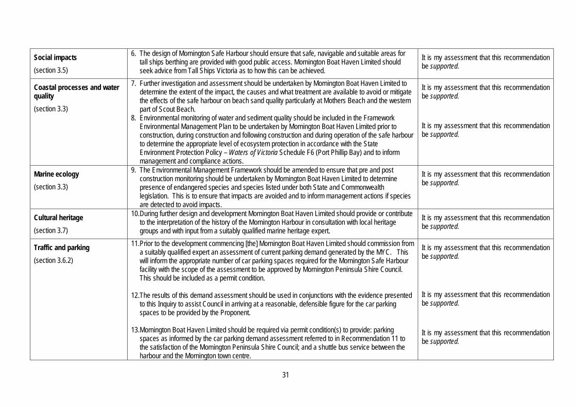
31
Social impacts
(section 3.5)
6. The design of Mornington Safe Harbour should ensure that safe, navigable and suitable areas for tall ships berthing are provided with good public access. Mornington Boat Haven Limited should seek advice from Tall Ships Victoria as to how this can be achieved.
It is my assessment that this recommendation be supported.
Coastal processes and water quality
(section 3.3)
7. Further investigation and assessment should be undertaken by Mornington Boat Haven Limited to determine the extent of the impact, the causes and what treatment are available to avoid or mitigate the effects of the safe harbour on beach sand quality particularly at Mothers Beach and the western part of Scout Beach.
8. Environmental monitoring of water and sediment quality should be included in the Framework Environmental Management Plan to be undertaken by Mornington Boat Haven Limited prior to construction, during construction and following construction and during operation of the safe harbour to determine the appropriate level of ecosystem protection in accordance with the State Environment Protection Policy – Waters of Victoria Schedule F6 (Port Phillip Bay) and to inform management and compliance actions.
It is my assessment that this recommendation be supported.
It is my assessment that this recommendation be supported.
Marine ecology
(section 3.3)
9. The Environmental Management Framework should be amended to ensure that pre and post construction monitoring should be undertaken by Mornington Boat Haven Limited to determine presence of endangered species and species listed under both State and Commonwealth legislation. This is to ensure that impacts are avoided and to inform management actions if species are detected to avoid impacts.
It is my assessment that this recommendation be supported.
Cultural heritage
(section 3.7)
10. During further design and development Mornington Boat Haven Limited should provide or contribute to the interpretation of the history of the Mornington Harbour in consultation with local heritage groups and with input from a suitably qualified marine heritage expert.
It is my assessment that this recommendation be supported.
Traffic and parking
(section 3.6.2)
11. Prior to the development commencing [the] Mornington Boat Haven Limited should commission from a suitably qualified expert an assessment of current parking demand generated by the MYC. This will inform the appropriate number of car parking spaces required for the Mornington Safe Harbour facility with the scope of the assessment to be approved by Mornington Peninsula Shire Council. This should be included as a permit condition.
12. The results of this demand assessment should be used in conjunctions with the evidence presented
to this Inquiry to assist Council in arriving at a reasonable, defensible figure for the car parking spaces to be provided by the Proponent.
13. Mornington Boat Haven Limited should be required via permit condition(s) to provide: parking
spaces as informed by the car parking demand assessment referred to in Recommendation 11 to the satisfaction of the Mornington Peninsula Shire Council; and a shuttle bus service between the harbour and the Mornington town centre.
It is my assessment that this recommendation be supported.
It is my assessment that this recommendation be supported.
It is my assessment that this recommendation be supported.

32
Net community benefit
(section 3.2)
No recommendations provided. -
Environmental management plan
(section 3.8)
14. The frequency and duration of beach monitoring on Mothers Beach, Scout Beach and Shire Hall Beach be increased to the three monthly after construction is completed, and the frequency reviewed in the 12 monthly review of the Operational Environmental Management Plan required in permit conditions depending on the monitoring results.
15. The Draft Framework Environmental Management Plan, as shown in Appendix E, be adopted for
use in further project design and development subject to: Deletion of reference to fore and aft and swing moorings. Inclusion under Section 3.3.1 of reference to the marina arms and pens and the wavescreens
requiring further environmental risk assessment. Inclusion of Mornington Boat Haven Limited’s statement of commitments (shown in Appendix F
of this report) in Section 4.1. Under ‘Marine Ecology’ in Table 2, pre construction and post construction monitoring for
species of State and National significance should be added as monitoring requirements.
It is my assessment that this recommendation be supported.
It is my assessment that this recommendation be supported.